NASA Discovers Salty Liquid Water Flows Intermittently on Mars Today, Bolstering Chance for Life

These dark, narrow, 100 meter-long streaks called recurring slope lineae flowing downhill on Mars are inferred to have been formed by contemporary flowing water. However, a new study by planetary scientists indicates that these may actually be the result of dry flows. Credits: NASA/JPL/University of Arizona

These dark, narrow, 100 meter-long streaks called recurring slope lineae flowing downhill on Mars are inferred to have been formed by contemporary flowing water. Recently, planetary scientists detected hydrated salts on these slopes at Hale crater, corroborating their original hypothesis that the streaks are indeed formed by liquid water. The blue color seen upslope of the dark streaks are thought not to be related to their formation, but instead are from the presence of the mineral pyroxene.

The image is produced by draping an orthorectified Infrared-Red-Blue/Green(IRB)) false color image on a Digital Terrain Model (DTM). This model was produced by researchers at the University of Arizona, much like the High Resolution Imaging Science Experiment (University of Arizona). The vertical exaggeration is 1.5.

NASA and Mars planetary scientists announced today (Sept. 28) that salty “liquid water flows intermittently” across multiple spots on the surface of today’s Mars – trumpeting a major scientific discovery with far reaching implications regarding the search for life beyond Earth and bolstering the chances for the possible existence of present day Martian microbes.

Utilizing spectroscopic measurements and imaging gathered by NASA’s Mars Reconnaissance Orbiter (MRO), researchers found the first strong evidence confirming that briny water flows on the Red Planet today along dark streaks moving downhill on crater slopes and mountain sides, during warmer seasons.

“Mars is not the dry, arid planet that we thought of in the past. Today we announce that under certain circumstances, liquid water has been found on Mars,” said Jim Green, NASA Planetary Science Director at NASA Headquarters, at a media briefing held today, Sept 28.

“When you look at Earth, water is an essential ingredient. Everywhere we go where there’s liquid water, whether its deep in the Earth or in the arid regions, we find life. This is tremendously exciting.”

“We haven’t been able to answer the question – does life exist beyond Earth? But following the water is a critical element of that. We now have great opportunities to be in the right locations on Mars to thoroughly investigate that,” Green elaborated.

“Water! Strong evidence that liquid water flows on present-day Mars,” NASA officials tweeted about the discovery.

The evidence comes in the form of the detection of mysterious dark streaks, as long as 100 meters, showing signatures of hydrated salt minerals periodically flowing in liquid water down steep slopes on the Red Planet that “appear to ebb and flow over time.”

The source of the water is likely from the shallow subsurface or possibly absorbed from the atmosphere.

Dark narrow streaks called recurring slope lineae emanating out of the walls of Garni crater on Mars. The dark streaks here are up to few hundred meters in length. They are hypothesized to be formed by flow of briny liquid water on Mars. The image is produced by draping an orthorectified (RED) image (ESP_031059_1685) on a Digital Terrain Model (DTM) of the same site produced by High Resolution Imaging Science Experiment (University of Arizona). Vertical exaggeration is 1.5.    Credits: NASA/JPL/University of Arizona
Dark narrow streaks called recurring slope lineae emanating out of the walls of Garni crater on Mars. The dark streaks here are up to few hundred meters in length. They are hypothesized to be formed by flow of briny liquid water on Mars. The image is produced by draping an orthorectified (RED) image (ESP_031059_1685) on a Digital Terrain Model (DTM) of the same site produced by High Resolution Imaging Science Experiment (University of Arizona). Vertical exaggeration is 1.5. Credits: NASA/JPL/University of Arizona

Water is a key prerequisite for the formation and evolution of life as we know it. So the new finding significantly bolsters the chances that present day extant life could exist on the Red Planet.

“Our quest on Mars has been to ‘follow the water,’ in our search for life in the universe, and now we have convincing science that validates what we’ve long suspected,” said John Grunsfeld, astronaut and associate administrator of NASA’s Science Mission Directorate in Washington.

“This is a significant development, as it appears to confirm that water — albeit briny — is flowing today on the surface of Mars.”

“This increases the chance that life could exist on Mars today,” noted Grunsfeld.

The data were gathered by and the conclusions are based on using two scientific instruments – the high resolution imaging spectrometer on MRO known as High Resolution Imaging Science Experiment (HiRISE), as well as MRO’s mineral mapping Compact Reconnaissance Imaging Spectrometer for Mars (CRISM).

The mysterious dark streaks of downhill flows are known as recurring slope lineae (RSL).

They were first detected in 2010 at dozens of sites on the sun facing slopes of deep craters by Lujendra Ojha, then a University of Arizona undergraduate student.

The new finding is highly significant because until today’s announcement, there was no strong evidence that liquid water could actually exist on the Martian surface because the atmospheric pressure was thought to be far too low – its less than one percent of Earth’s.

The flow of water is occasional and not permanent, seasonally variable and dependent on having just the right mix of atmospheric, temperature and surface conditions with salt deposits on Mars.

Portions of Mars were covered with an ocean of water billions of years ago when the planet was far warmer and more hospitable to life. But it underwent a dramatic climate change some 3 billion years ago and lost most of that water.

The RSL with flowing water appear in at least three different locations on Mars – including Hale crater, Horowitz crater and Palikir crater – when temperatures are above minus 10 degrees Fahrenheit (minus 23 Celsius). They appear during warm seasons, fade in cooler seasons and disappear during colder times.

Pure surface water ice would simply sublimate and evaporate away as the temperature rises. Mixing in surface salts lowers the melting point of ice, thereby allowing the water to potentially liquefy on Mars surface for a certain period of time rather than sublimating rapidly away.

“These are dark streaks that form in late spring, grow through the summer and then disappear in the fall,” said Michael Meyer lead scientist for the Mars Exploration Program at NASA Headquarters, at the media briefing.

Years of painstaking effort and laboratory work was required to verify and corroborate the finding of flowing liquid water.

“It took multiple spacecraft over several years to solve this mystery, and now we know there is liquid water on the surface of this cold, desert planet,” said Meyer. “It seems that the more we study Mars, the more we learn how life could be supported and where there are resources to support life in the future.”

The dark, narrow streaks flowing downhill on Mars at sites such as this portion of Horowitz Crater are inferred to be formed by seasonal flow of water on modern-day Mars. The streaks are roughly the length of a football field. These dark features on the slopes are called "recurring slope lineae" or RSL. The imaging and topographical information in this processed view come from the High Resolution Imaging Science Experiment (HiRISE) camera on NASA's Mars Reconnaissance Orbiter.   Credit: NASA/JPL-Caltech/Univ. of Arizona
The dark, narrow streaks flowing downhill on Mars at sites such as this portion of Horowitz Crater are inferred to be formed by seasonal flow of water on modern-day Mars. The streaks are roughly the length of a football field. These dark features on the slopes are called “recurring slope lineae” or RSL. The imaging and topographical information in this processed view come from the High Resolution Imaging Science Experiment (HiRISE) camera on NASA’s Mars Reconnaissance Orbiter. Credit: NASA/JPL-Caltech/Univ. of Arizona

Along with the media announcement, the researchers published their findings today in a refereed scientific paper in the Sept. 28 issue of Nature Geoscience.

“We found the hydrated salts only when the seasonal features were widest, which suggests that either the dark streaks themselves or a process that forms them is the source of the hydration. In either case, the detection of hydrated salts on these slopes means that water plays a vital role in the formation of these streaks,” said Lujendra Ojha, now at the Georgia Institute of Technology (Georgia Tech) in Atlanta, and lead author of the Sept. 28 publication in Nature Geoscience.

The scientists “interpret the spectral signatures as caused by hydrated minerals called perchlorates.”

Ojha said the chemical signatures from CRISM were most consistent with the detection of mixtures of magnesium perchlorate, magnesium chlorate and sodium perchlorate, based on lab experiments.

“Some perchlorates have been shown to keep liquids from freezing even when conditions are as cold as minus 94 degrees Fahrenheit (minus 70 Celsius).”

Perchlorates have previously been detected in Martian soil by two of NASA’s surface missions – the Phoenix lander and the Curiosity rover. There is also some evidence that NASA’s Viking missions in the 1970s measured signatures of these salts.

On Earth concentration of perchlorates are found in deserts.

This also marks the first time perchlorates have been identified from Mars orbit.

Locations of RSL features on Mars

NASA’s overriding agency wide goal is to send humans on a ‘Journey to Mars’ in the 2030s.

So NASA astronaut Mark Kelly exclaimed that he was also super excited about the findings, from his perch serving as Commander aboard the International Space Station (ISS), where he is a member of the first ever “1 Year ISS Mission Crew” aimed at learning how the human body will adapt to the long term missions required to send astronauts to Mars and back.

“One reason why NASA’s discovery of liquid water on #Mars is so exciting: we know anywhere there’s water on Earth, there’s some form of life,” Kelly tweeted today from on board the ISS, upon hearing today’s news.

The discovery of liquid water on Mars could also be a boon to future astronauts who could use it as a natural resource to ‘live off the land’ for sustenance and to make rocket fuel.

“If going to Mars on my Year In Space, I’d arrive soon to find water! H20 > rocket fuel, which means I could find my way back home too!,” Kelly wrote on his Facebook page.

“When most people talk about water on Mars, they’re usually talking about ancient water or frozen water,” Ojha explained.

“Now we know there’s more to the story. This is the first spectral detection that unambiguously supports our liquid water-formation hypotheses for RSL.”

Stay tuned here for Ken’s continuing Earth and planetary science and human spaceflight news.

Ken Kremer

A Bloody Beautiful Supermoon Eclipse!

"The red Moon did not disappoint tonight," writes Arnar Kristjansson. Credit: Arnar Kristjansson

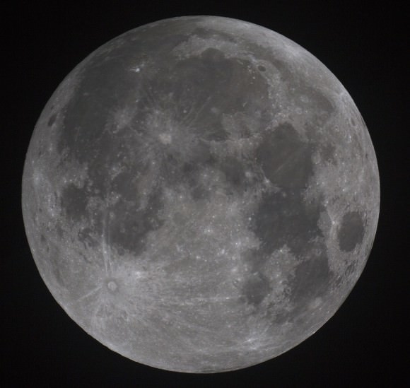
Like some of you, I outran the clouds just in time to catch last night’s total lunar eclipse. What a beautiful event! Here are some gorgeous pictures from our readers and Universe Today staff — souvenirs if you will — of the last total lunar eclipse anywhere until January 31, 2018. The sky got so dark, and the Moon hung like a plum in Earth’s shadow for what seemed a very long time. Did you estimate the Moon’s brightness on the Danjon Scale? My brother and I both came up with L=2 from two widely-separated locations; William Wiethoff in Hayward, Wisconsin rated it L=1. All three estimates would indicate a relatively dark eclipse.

Nicely-done sequence of eclipse phases taken early September 28, 2015. Credit: Own Llewellyn
Nicely-done sequence of eclipse phases taken early September 28, 2015. Click to enlarge. Credit: Own Llewellyn

The darkness of the umbra was particularly noticeable in the west quarter of the Moon in the giant volcanic plain known as Oceanus Procellarum. This makes sense as that portion of the Moon was located closest to the center of the Earth’s dark, inner umbra. The plain is also dark compared to the brighter lunar highlights, which being more reflective, formed a sort of pale ring around the northern rim of the lunar disk.

Salute to the eclipse! Credit: Jason Major
Salute to the final eclipse of the current tetrad that began 17 months ago.  Credit: Jason Major

The bottom or southern rim of the Moon, located farthest from the center of the umbra, appeared a lighter yellow-orange throughout totality.

Wide angle view of the Moon during totality in star-rich sky with the Aquila Milky visible at right. Credit: Bob King
Wide angle view of the Moon (lower left) during totality in a star-rich sky with the Aquila Milky Way visible at right. Credit: Bob King

This is just a small sampling of the excellent images arriving from our readers. More are flowing in on Universe Today’s Flickr site.  Thank you everyone for your submissions!

A crowd gather to watch the Moon during partial eclipse prior to totality. Credit: Robert Sparks
A hint of the penumbra shows in this photo. Hint: look near left top. Credit: Roger Hutchinson
A bloody Moon iindeed! Credit: Chris Lyons
A bloody Moon iindeed! Notice how dark Oceanus Procellarum (top) appears. Credit: Chris Lyons
"Super Blood Moon". Credit: Alok SInghal
“Super Blood Moon”. Credit: Alok Singhal
Nice montage of images from eclipse start to finish. Credit: Mike Greenham
One of the most awesome aspects of the eclipse was how many stars could be seen near the Moon. This picture was taken with a 100mm telesphoto lens. Credit: Bob King
Rare shot of the totally eclipsed Moon and bright meteor. Credit: VegaStar Carpentier Photography
A lucky break in the clouds made this photographer happy. Credit: Moe Ali
Mary Spicer made exposures every 5 minutes. During totality the Moon dropped behind a tree so I had to relocate the camera, hence the small gap in the sequence. 35 shots in total, stacked using StarStax. Credit: Mary Spicer
Mary Spicer made exposures of the eclipsed Moon every 5 minutes. During totality, the Moon dropped behind a tree so she had to relocate the camera, hence the small gap in the sequence. 35 shots in total and stacked into one frame using StarStax. Credit: Mary Spicer
The Moon caught after totality between clouds through a small refracting telescope. Credit: Bob King
Another nice montage displaying all the partial phases, early, mid and late totality. Credit: Andre van der Hoeven
Another fine montage displaying all the partial phase plus early, mid and late totality. Credit: Andre van der Hoeven

Astonishing ‘Snakeskin’ Textured Mountains Discovered on Pluto

This color image of Pluto taken by NASA’s New Horizons spacecraft shows rounded and bizarrely textured mountains, informally named the Tartarus Dorsa, rise up along Pluto’s terminator and show intricate but puzzling patterns of blue-gray ridges and reddish material in between. This view, roughly 330 miles (530 kilometers) across, combines blue, red and infrared images taken by the Ralph/Multispectral Visual Imaging Camera (MVIC) on July 14, 2015, and resolves details and colors on scales as small as 0.8 miles (1.3 kilometers). Credits: NASA/JHUAPL/SWRI

The more we learn about Pluto, the weirder and weirder it gets.

The newest batch of high resolution Plutonian images has yielded “astonishing” discoveries of previously unseen ‘snakeskin’ textured mountains, that are simultaneously “dazzling and mystifying” scientists analyzing the latest data just returned from NASA’s New Horizons spacecraft.

New Horizons swooped past the Pluto planetary system during mankind’s history making first encounter on July 14, 2015 at a distance of 50,000 miles (80,000 kilometers).

The piano shaped probe gathered about 50 gigabits of data as it hurtled past Pluto, its largest moon Charon and four smaller moons.

Data from that priceless, once in a lifetime flyby is now trickling back to Earth.

The ‘snakeskin’ feature on Pluto’s utterly bizarre surface was unveiled to “astonished” scientists scrutinizing the latest data dump received over the past week, that included images taken by the Ralph instruments Multispectral Visual Imaging Camera (MVIC).

Features as small as 0.8 miles (1.3 kilometers) are resolved in detail.

The MVIC image stretches about 330 miles (530 kilometers) across the ‘snakeskin’ like landscape composed of rounded and bizarrely textured mountains that are informally named Tartarus Dorsa and that borders the bodies day-night terminator.

It shows intricate patterns of blue-gray ridges and reddish material in between that are puzzling researchers.

“It’s a unique and perplexing landscape stretching over hundreds of miles,” said William McKinnon, New Horizons Geology, Geophysics and Imaging (GGI) team deputy lead from Washington University in St. Louis.

“It looks more like tree bark or dragon scales than geology. This’ll really take time to figure out; maybe it’s some combination of internal tectonic forces and ice sublimation driven by Pluto’s faint sunlight.”

The Ralph/MVIC image is actually a composite of blue, red and infrared images.

The image of Tartarus Dorsa reveals a “multitude of previously unseen topographic and compositional details. It captures a vast rippling landscape of strange, aligned linear ridges that has astonished New Horizons team members,” say officials.

NASA’s New Horizons spacecraft captured this high-resolution enhanced color view of Pluto on July 14, 2015. The image combines blue, red and infrared images taken by the Ralph/Multispectral Visual Imaging Camera (MVIC). Pluto’s surface sports a remarkable range of subtle colors, enhanced in this view to a rainbow of pale blues, yellows, oranges, and deep reds. Many landforms have their own distinct colors, telling a complex geological and climatological story that scientists have only just begun to decode. The image resolves details and colors on scales as small as 0.8 miles (1.3 kilometers).  The viewer is encouraged to zoom in on the image on a larger screen to fully appreciate the complexity of Pluto’s surface features.   Credit: NASA/JHUAPL/SwRI
NASA’s New Horizons spacecraft captured this high-resolution enhanced color view of Pluto on July 14, 2015. The image combines blue, red and infrared images taken by the Ralph/Multispectral Visual Imaging Camera (MVIC). Pluto’s surface sports a remarkable range of subtle colors, enhanced in this view to a rainbow of pale blues, yellows, oranges, and deep reds. Many landforms have their own distinct colors, telling a complex geological and climatological story that scientists have only just begun to decode. The image resolves details and colors on scales as small as 0.8 miles (1.3 kilometers). The viewer is encouraged to zoom in on the image on a larger screen to fully appreciate the complexity of Pluto’s surface features. Credit: NASA/JHUAPL/SwRI

Another wider angle global view of Pluto downlinked on Sept. 19 shows a new “extended color” view of Pluto with an the extraordinarily rich color palette of the planet.

“We used MVIC’s infrared channel to extend our spectral view of Pluto,” said John Spencer, a GGI deputy lead from Southwest Research Institute (SwRI) in Boulder, Colorado.

“Pluto’s surface colors were enhanced in this view to reveal subtle details in a rainbow of pale blues, yellows, oranges, and deep reds. Many landforms have their own distinct colors, telling a wonderfully complex geological and climatological story that we have only just begun to decode.”

The image resolves details and colors on scales as small as 0.8 miles (1.3 kilometers).

High-resolution images of Pluto taken by NASA’s New Horizons spacecraft just before closest approach on July 14, 2015, reveal features as small as 270 yards (250 meters) across, from craters to faulted mountain blocks, to the textured surface of the vast basin informally called Sputnik Planum. Enhanced color has been added from the global color image. This image is about 330 miles (530 kilometers) across. For optimal viewing, zoom in on the image on a larger screen.  Credits: NASA/JHUAPL/SWRI
High-resolution images of Pluto taken by NASA’s New Horizons spacecraft just before closest approach on July 14, 2015, reveal features as small as 270 yards (250 meters) across, from craters to faulted mountain blocks, to the textured surface of the vast basin informally called Sputnik Planum. Enhanced color has been added from the global color image. This image is about 330 miles (530 kilometers) across. For optimal viewing, zoom in on the image on a larger screen. Credits: NASA/JHUAPL/SWRI

Beyond MVIC, additional new images taken by New Horizons’ narrow-angle Long Range Reconnaissance Imager (LORRI) during the July 14 were downlinked on Sept. 20.

They focus on the Sputnik Planum ice plains on the left side of the famous heart shaped Tombaugh Regio feature and are the highest resolution yet – as seen below. The team added color based on the global MVIC map shown above.

High-resolution images of Pluto taken by NASA’s New Horizons spacecraft just before closest approach on July 14, 2015, are the sharpest images to date of Pluto’s varied terrain—revealing details down to scales of 270 meters. In this 75-mile (120-kilometer) section of the taken from a larger, high-resolution mosaic, the textured surface of the plain surrounds two isolated ice mountains.  Credits: NASA/JHUAPL/SWRI
High-resolution images of Pluto taken by NASA’s New Horizons spacecraft just before closest approach on July 14, 2015, are the sharpest images to date of Pluto’s varied terrain—revealing details down to scales of 270 meters. In this 75-mile (120-kilometer) section of the taken from a larger, high-resolution mosaic, the textured surface of the plain surrounds two isolated ice mountains. Credits: NASA/JHUAPL/SWRI

Barely 5 or 6 percent of the 50 gigabits of data captured by New Horizons has been received by ground stations back on Earth.

“With these just-downlinked images and maps, we’ve turned a new page in the study of Pluto beginning to reveal the planet at high resolution in both color and composition,” added New Horizons Principal Investigator Alan Stern, of SwRI.

“I wish Pluto’s discoverer Clyde Tombaugh had lived to see this day.”

Stern says it will take about a year for all the data to get back. Thus bountiful new discoveries are on tap.

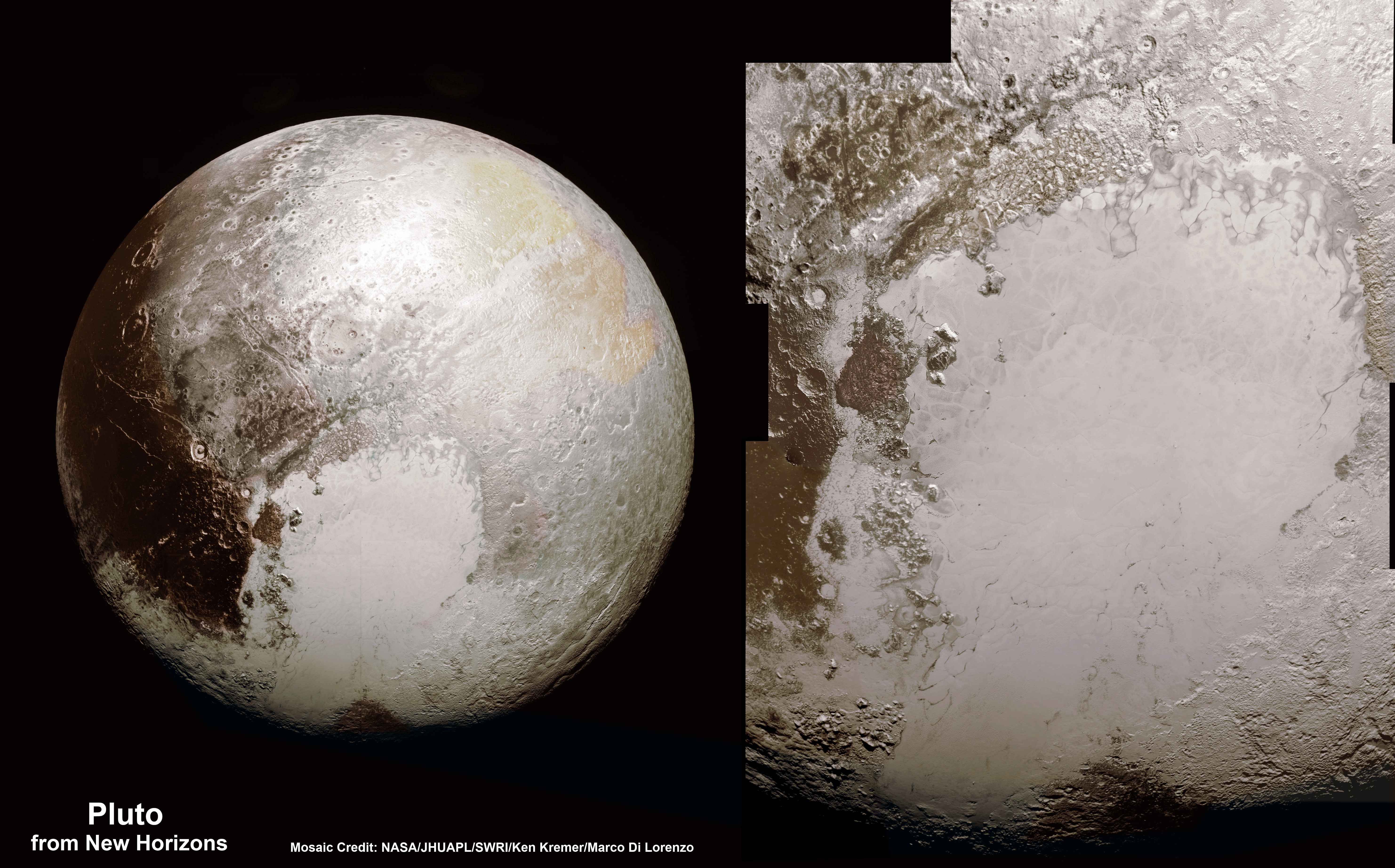
This new global mosaic view of Pluto was created from the latest high-resolution images to be downlinked from NASA’s New Horizons spacecraft and released on Sept. 11, 2015.   The images were taken as New Horizons flew past Pluto on July 14, 2015, from a distance of 50,000 miles (80,000 kilometers).  This mosaic was stitched from over two dozen raw images captured by the LORRI imager and colorized.  Right side mosaic comprises twelve highest resolution views of Tombaugh Regio heart shaped feature and shows objects as small as 0.5 miles (0.8 kilometers) in size.  Credits: NASA/Johns Hopkins University Applied Physics Laboratory/Southwest Research Institute/ Ken Kremer/kenkremer.com/Marco Di Lorenzo
This new global mosaic view of Pluto was created from the latest high-resolution images to be downlinked from NASA’s New Horizons spacecraft and released on Sept. 11, 2015. The images were taken as New Horizons flew past Pluto on July 14, 2015, from a distance of 50,000 miles (80,000 kilometers). This mosaic was stitched from over two dozen raw images captured by the LORRI imager and colorized. Right side mosaic comprises twelve highest resolution views of Tombaugh Regio heart shaped feature and shows objects as small as 0.5 miles (0.8 kilometers) in size. Credits: NASA/Johns Hopkins University Applied Physics Laboratory/Southwest Research Institute/ Ken Kremer/kenkremer.com/Marco Di Lorenzo

Stay tuned here for Ken’s continuing Earth and planetary science and human spaceflight news.

Ken Kremer

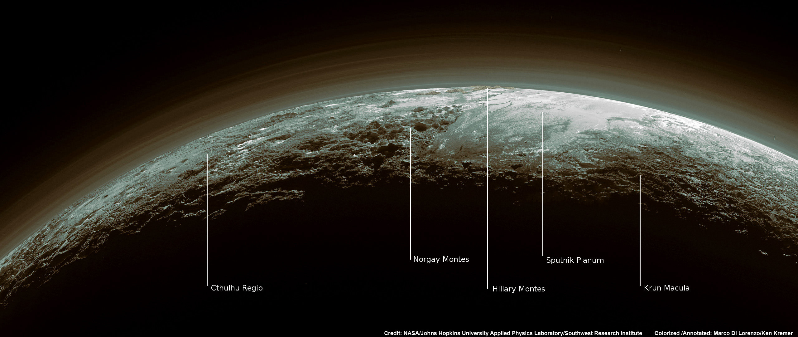
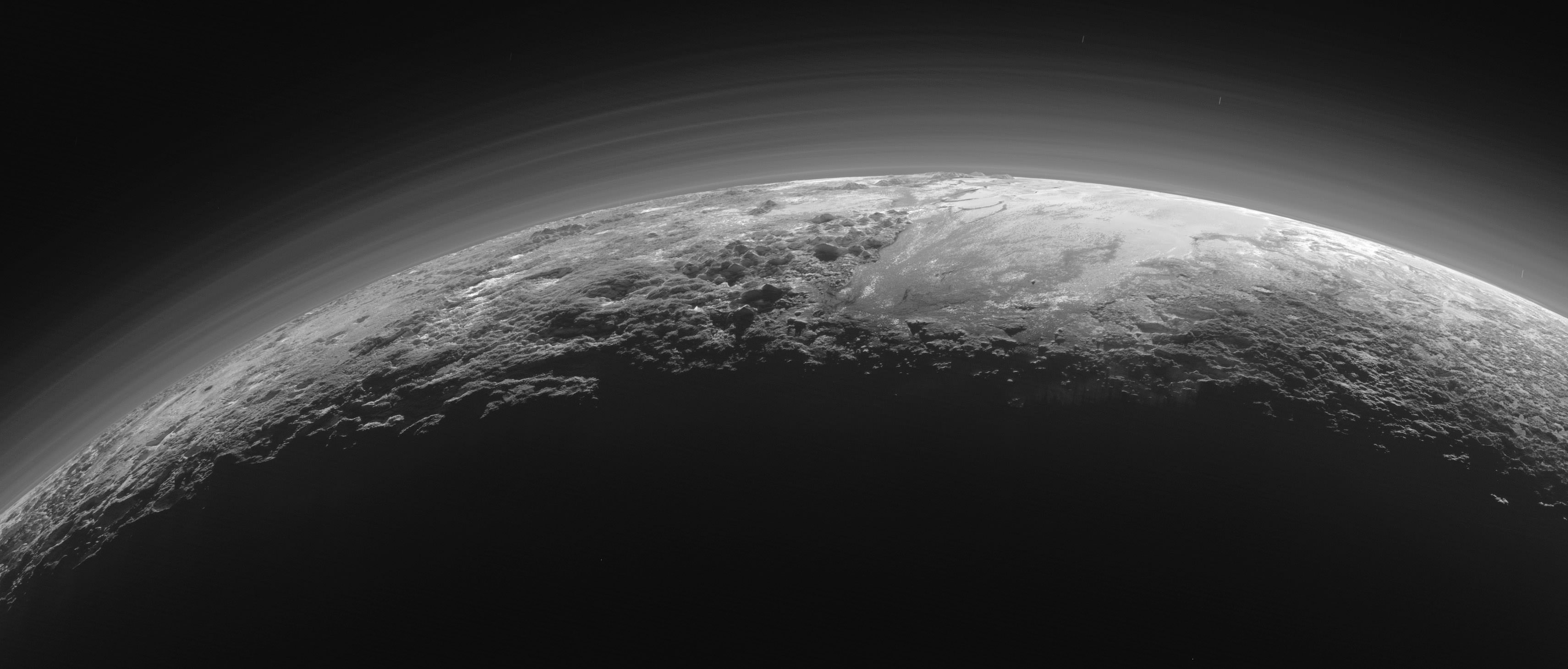
Just 15 minutes after its closest approach to Pluto on July 14, 2015, NASA's New Horizons spacecraft looked back toward the sun and captured this near-sunset view of the rugged, icy mountains and flat ice plains extending to Pluto's horizon - shown in this colorized rendition. The smooth expanse of the informally named icy plain Sputnik Planum (right) is flanked to the west (left) by rugged mountains up to 11,000 feet (3,500 meters) high, including the informally named Norgay Montes in the foreground and Hillary Montes on the skyline. To the right, east of Sputnik, rougher terrain is cut by apparent glaciers. The backlighting highlights more than a dozen layers of haze in Pluto’s tenuous but distended atmosphere. The image was taken from a distance of 11,000 miles (18,000 kilometers) to Pluto; the scene is 780 miles (1,250 kilometers) wide. Credit: NASA/Johns Hopkins University Applied Physics Laboratory/Southwest Research Institute. Colorized/Annotated: Marco Di Lorenzo/Ken Kremer/kenkremer.com
Just 15 minutes after its closest approach to Pluto on July 14, 2015, NASA’s New Horizons spacecraft looked back toward the sun and captured this near-sunset view of the rugged, icy mountains and flat ice plains extending to Pluto’s horizon – shown in this colorized rendition. The smooth expanse of the informally named icy plain Sputnik Planum (right) is flanked to the west (left) by rugged mountains up to 11,000 feet (3,500 meters) high, including the informally named Norgay Montes in the foreground and Hillary Montes on the skyline. To the right, east of Sputnik, rougher terrain is cut by apparent glaciers. The backlighting highlights more than a dozen layers of haze in Pluto’s tenuous but distended atmosphere. The image was taken from a distance of 11,000 miles (18,000 kilometers) to Pluto; the scene is 780 miles (1,250 kilometers) wide. Credit: NASA/Johns Hopkins University Applied Physics Laboratory/Southwest Research Institute. Colorized/Annotated: Marco Di Lorenzo/Ken Kremer/kenkremer.com

Matt Damon of ‘The Martian’ Explains NASA’s Journey to Mars – ISS Crew Previews Film on Orbit

Watched @MartianMovie on @Space_Station last night! Today working towards our #JourneyToMars during my #YearInSpace!” Credit: NASA/Scott Kelly

Video caption: ‘The Martian’ Star Matt Damon Discusses NASA’s Journey to Mars. Credit: NASA

The excitement is building for the worldwide movie premiere of ‘The Martian’ on Oct. 2.

Based on the bestselling book by Andy Weir, ‘The Martian’ tells the story of how NASA astronaut Mark Watney, played by Matt Damon, is accidentally stranded on the surface of Mars during a future manned expedition, after a sudden and unexpectedly fierce dust storm forces the rest of the crew to quickly evacuate after they believe he is dead.

In the video above, Matt Damon discusses NASA’s ongoing real life efforts focused on turning science fiction dreams into reality and sending astronauts to Mars.

Watney actually survived the storm but lost contact with NASA. The film recounts his ingenious years long struggle to survive, figure out how to tell NASA he is alive and send a rescue crew before he starves to death on a planet where nothing grows. Watney’s predicament is a survival lesson to all including NASA.

‘The Martian’ was written by Andy Weir in 2010 and has now been produced as a major Hollywood motion picture starring world famous actor Matt Damon and directed by the world famous director Ridley Scott from 20th Century Fox.

NASA’s overriding strategic goal is to send humans on a ‘Journey to Mars’ by the 2030s.

‘The Martian’ is a rather realistic portrayal of how NASA might accomplish the ‘Journey to Mars.’

“Sending people to Mars and returning them safely is the challenge of a generation,” says Damon in the video.

“The boot prints of astronauts will follow the rover tracks [of NASA’s Curiosity rover] thanks to innovations happening today.”

“NASA’s Journey to Mars begins on the International Space Station (ISS) .. where we are learning how humans can thrive over long periods without gravity.”

The current six person crew serving aboard the ISS even got a sneak preview of The Martian this past weekend!

Gleeful NASA astronaut Scott Kelly, commander of the Expedition 45 crew, just tweeted a photo of the crew watching ‘The Martian’ while soaring some 250 miles (400 kilometers) above Earth.

“Watched @MartianMovie on @Space_Station last night! Today working towards our #JourneyToMars during my #YearInSpace!” tweeted NASA astronaut Scott Kelly.

Kelly comprises one half of the first ever ‘1 Year ISS Crew’ along with Russian cosmonaut Mikhail Kornienko, aimed at determining the long term physical and psychological effects on the human body of people living and working in the weightlessness of space.

The 1 Year ISS mission is an important data gathering milestone on the human road to Mars since the round trip time to the Red Planet and back will take approximately 3 years or more.

In order to send astronauts to the Red Planet, NASA is now developing the mammoth Space Launch System (SLS) heavy lift booster and the Orion crew capsule to propel astronauts farther than ever before on the Journey to Mars.

The first unmanned test flight of SLS/Orion is slated for Nov. 2018. The first manned flight could occur between 2021 and 2023 – read my new report here.

“The Journey to Mars will forever change our history books … and expand our human presence deeper into the solar system,” says Damon.

THE MARTIAN features a star studded cast that includes Matt Damon, Jessica Chastain, Kristen Wiig, Kate Mara, Michael Pena, Jeff Daniels, Chiwetel Ejiofor, and Donald Glover.

Matt Damon stars as NASA astronaut Mark Watney in ‘The Martian.' Credit: 20th Century Fox
Matt Damon stars as NASA astronaut Mark Watney in ‘The Martian.’ Credit: 20th Century Fox

“NASA has endorsed “The Martian’” Jim Green, NASA’s Director of Planetary Sciences, told Universe Today. Green served as technical consultant on the film.

I have read the book (I’m a professional chemist) and highly recommend it to everyone.

The Martian is all about how Watney uses his botany and chemistry skills to “Science the Sh.. out of it” to grow food and survive.

Learning how to live of the land will be a key hurdle towards enabling long term space voyages.

Kelly and his ISS cremates took a big first step towards putting that theory into practice when they recently grew, harvested and ate the first space grown NASA lettuce on the ISS using the Veggie experimental rack – detailed in my recent story here.

NASA Astronauts Kjell Lindgren (center) and Scott Kelly (right) and Kimiya Yui (left) of Japan consume space grown food for the first time ever, from the aboard the  from the Veggie plant growth system on the International Space Station.  Credit: NASA TV
NASA Astronauts Kjell Lindgren (center) and Scott Kelly (right) and Kimiya Yui (left) of Japan consume space grown food for the first time ever, from the Veggie plant growth system on the International Space Station. Credit: NASA TV

Here’s the second official trailer of “The Martian:

Stay tuned here for Ken’s continuing Earth and planetary science and human spaceflight news.

Ken Kremer

Veggie demonstration apparatus growing red romaine lettuce under LED lights in the Space Station Processing Facility at NASA’s Kennedy Space Center.  Credit: Ken Kremer/kenkremer.com
Veggie demonstration apparatus growing red romaine lettuce under LED lights in the Space Station Processing Facility at NASA’s Kennedy Space Center. Credit: Ken Kremer/kenkremer.com

Boeing Rejects Aerojet Rocketdyne Bid for ULA and Affirms Vulcan Rocket Support, Lockheed Martin Noncommittal

Rendering of the ULA Vulcan rocket blasting off. United Launch Alliance (ULA) next generation rocket is set to make its debut flight in 2019. Credit: ULA

Boeing has officially and publicly rejected a bid by Aerojet Rocketdyne to buy rocket maker United Launch Alliance (ULA), which the firm co-owns with rival aerospace giant Lockheed Martin. Furthermore Boeing affirmed support for ULA’s new next generation Vulcan rocket now under development, a spokesperson confirmed to Universe Today.

Aerojet Rocketdyne, which supplies critical rocket engines powering ULA’s fleet of Atlas and Delta rockets, recently made an unsolicited offer to buy ULA for approximately $2 Billion in cash, as Universe Today reported last week.

The Vulcan is planned to replace all of ULA’s existing rockets – which are significantly more costly than those from rival launch provider SpaceX, founded by billionaire entrepreneur Elon Musk.

Boeing never “seriously entertained” the Aerojet-Rocketdyne buyout offer, Universe Today confirmed with Boeing spokesperson Cindy Anderson.

Meanwhile in stark contrast to Boeing, Lockheed Martin has “no comment” regarding the Aerojet-Rocketdyne offer to buy ULA, Universe Today confirmed with Lockheed Martin Director External Communications Matt Kramer.

Furthermore Lockheed Martin is not only noncommittal about the future of ULA but is also “currently assessing our options” concerning the development of ULA’s Vulcan rocket, Kramer told me.

“With regard to reports of an unsolicited proposal for ULA, it is not something we seriously entertained for a number of reasons,” Boeing spokesperson Anderson told Universe Today.

“Regarding Aerojet and ULA, as a matter of policy Lockheed Martin does not have a comment,” Lockheed Martin spokesman Kramer told Universe Today.

Vulcan - United Launch Alliance (ULA)  next generation rocket is set to make its debut flight in 2019.  Credit: ULA
Vulcan – United Launch Alliance (ULA) next generation rocket is set to make its debut flight in 2019. Credit: ULA

ULA was formed in 2006 as a 50:50 joint venture between Lockheed Martin and Boeing that combined their existing expendable rocket fleet families – the Atlas V and Delta IV – under one roof.

Who owns ULA is indeed of significance to all Americans – although most have never head of the company – because ULA holds a virtual monopoly on launches of vital US government national security payloads and the nation’s most critical super secret spy satellites that safeguard our national defense 24/7. ULA’s rocket fleet also launched scores of NASA’s most valuable science satellites including the Curiosity Mars rover, Dawn and New Horizons Pluto planetary probe.

Since 2006 ULA has enjoyed phenomenal launch success with its venerable fleet of Atlas V and Delta IV rockets.

“ULA is a huge part of our strategic portfolio going forward along with our satellites and manned space business. This bid we’ve really not spent much time on it at all because we’re focusing on a totally different direction,” said Chris Chadwick, president and chief executive of Boeing Defense, Space & Security, on Sept. 16 at the Air Force Association’s annual technology expo in National Harbor, Maryland – according to a report by Space News.

Boeing offered strong support for ULA and the Vulcan rocket.

Vulcan is ULA’s next generation rocket to space that can propel payloads to low Earth orbit as well as throughout the solar system – including Pluto. It is slated for an inaugural liftoff in 2019.

Vulcan’s continued development is being funded by Lockheed Martin and Boeing, but only on a quarterly basis.

The key selling point of Vulcan is that it will be an all American built rocket and it will dramatically reduce launch costs to compete toe to toe with the SpaceX Falcon rocket family.

“To be successful and survive ULA needs to transform to be more of a competitive company in a competitive environment,” ULA VP Dr. George Sowers told Universe Today in a wide ranging interview regarding the rationale and goals of the Vulcan rocket.

And there is a heated competition on which of two companies will provide the new American built first stage engine that will replace the Russian-built RD-180 that currently powers the ULA Atlas V.

Vulcan’s first stage will most likely be powered by the BE-4 engine being developed by the secretive Blue Origin aerospace firm owned by billionaire Jeff Bezos.

This week ULA announced an expanded research agreement with Blue Origin about using the BE-4.

But ULA is also evaluating the AR-1 liquid fueled engine being developed by Aerojet-Rocketdyne – the company that wants to buy ULA.

The Atlas V dependence on Russia’s RD-180’s landed at the center of controversy after Russia invaded Crimea in the spring of 2014, raising the ire of Congress and enactment of a ban on their use several years in the future.

ULA is expected to make a final decision on which first stage engine to use between Blue Origin and Aerojet-Rocketdyne, sometime in 2016.

The engine choice would clearly be impacted if Aerojet-Rocketdyne buys ULA.

Boeing for its part says they strongly support ULA and continued development of the Vulcan.

“Boeing is committed to ULA and its business, and to continued leadership in all aspects of space, as evidenced by the recent announcement of an agreement with Blue Origin,” Boeing spokesperson Anderson told me.

Lockheed Martin in complete contrast did not express any long term commitment to Vulcan and just remarked they were merely “actively evaluating continued investment,” as is their right as a stakeholder.

“We have made no long-term commitments on the funding of a new rocket, and are currently assessing our options. The board is actively evaluating continued investment in the new rocket program and will continue to do so,” Lockheed Director, External Communications Matt Kramer told Universe Today.

Another factor is that Aerojet-Rocketdyne has also sought to buy the rights to manufacture the Atlas V from ULA, which is currently planned to be retired several years after Vulcan is introduced, officials have told me.

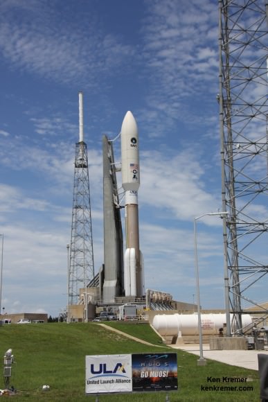
MUOS-4 US Navy communications satellite and Atlas V rocket at pad 41 at Cape Canaveral Air Force Station, FL for launch on Sept. 2, 2015 at 5:59 a.m. EDT. Credit: Ken Kremer/kenkremer.com
Aerojet-Rocketdyne made a bid to buy ULA, manufacturer of the Atlas V, for approximately $2 Billion. MUOS-4 US Navy communications satellite and Atlas V rocket at pad 41 at Cape Canaveral Air Force Station, FL for launch on Sept. 2, 2015 at 5:59 a.m. EDT. Credit: Ken Kremer/kenkremer.com

The Atlas V enjoys unparalleled success. Earlier this month on Sept. 2, ULA conducted its 99th launch with the successful blastoff of an Atlas V with the MUOS-4 military communications satellite from Cape Canaveral Air Force Station for the U.S. Navy.

Boeing has also chosen the Atlas V as the launcher that will soon propel Americans astronauts riding aboard the commercially developed Boeing CST-100 ‘Starliner’ taxi to the Earth-orbiting International Space Station (ISS).

Starliner will eventually blastoff atop Vulcan after the Atlas V is retired in the next decade.

Lockheed provided me this update on Vulcan and ULA on Sept 21:

“Lockheed Martin is proud of ULA’s unparalleled track record of mission success, with 99 consecutive successful launches to date. We support the important role ULA plays in providing the nation with assured access to space. ULA’s Vulcan rocket takes the best performance elements of Atlas and Delta and combines them in a new system that will be superior in reliability, cost, weight, and capability. The government is working to determine its strategy for an American-made engine and future launch services. As they make those determinations we’ll adjust our strategy to make sure we’re aligned with the government’s objectives and goals.”

Stay tuned here for Ken’s continuing Earth and planetary science and human spaceflight news.

Ken Kremer

First view of upper half of the Boeing CST-100 'Starliner' crewed space taxi unveiled at the Sept. 4, 2015 Grand Opening ceremony held in the totally refurbished C3PF manufacturing facility at NASA's Kennedy Space Center. This will be part of the first Starliner crew module known as the Structural Test Article (STA) being built at Boeing’s Commercial Crew and Cargo Processing Facility (C3PF) at KSC. Credit: Ken Kremer /kenkremer.com
First view of upper half of the Boeing CST-100 ‘Starliner’ crewed space taxi unveiled at the Sept. 4, 2015 Grand Opening ceremony held in the totally refurbished C3PF manufacturing facility at NASA’s Kennedy Space Center. This will be part of the first Starliner crew module known as the Structural Test Article (STA) being built at Boeing’s Commercial Crew and Cargo Processing Facility (C3PF) at KSC. Credit: Ken Kremer /kenkremer.com

First Manned Flight of NASA’s Orion Deep Space Capsule Could Slip to 2023

NASA Orion spacecraft blasts off atop 1st Space Launch System rocket in 2017 - attached to European provided service module – on an enhanced m mission to Deep Space where an asteroid could be relocated as early as 2021. Credit: NASA

The first manned flight of NASA’s Orion deep space capsule – currently under development – could slip two years from 2021 to 2023 due to a variety of budget and technical issues, top NASA officials announced on Wednesday, Sept. 16.

The potential two year postponement of Orion’s first flight with astronauts follows on the heels of the agency’s recently completed rigorous review of the programs status from a budgetary, technical, engineering, safety and risk assessment analysis of the vehicles systems and subsystems.

But Orion’s launch delay has already been condemned by some in Congress who accuse the Obama Administration of purposely shortchanging funding for the program.

Based on the budget available and all the work remaining to be accomplished, liftoff of the first Orion test flight with an astronaut crew is likely to occur “no later than April 2023,” said NASA Associate Administrator Robert Lightfoot at the Sept. 16 briefing for reporters.

NASA had been marching towards an August 2021 liftoff for the maiden crewed Orion on a test flight dubbed Exploration Mission-2 (EM-2), until Lightfoot’s announcement.

Lightfoot added that although August 2021 is still NASA’s officially targeted launch date for EM-2, achieving that early goal is not likely as a direct result of the program review.

“The team is still working toward a launch in August 2021, but have much less confidence in achieving that. But we are not changing that date for EM-2 at this time.”

“But we’re committing that we’ll be no later than April 2023.”

“It’s not a very high confidence level [on making the August 2021 launch date], I’ll tell you that, just because of the things we see historically pop up.”

Orion is being developed by NASA to send America’s astronauts on journeys venturing farther into deep space than ever before – back to the Moon first and then beyond to Asteroids, Mars and other destinations in our Solar System.

Artist's conception of NASA's Space Launch System with Orion crewed deep space capsule. Credit: NASA
Artist’s conception of NASA’s Space Launch System with Orion crewed deep space capsule. Credit: NASA

Orion’s likely launch slip is the direct fallout from NASA’s recently completed internal program review called Key Decision Point C (KDP-C).

The KDC-P review assesses all the technological work and advancements required for launch to design, develop and manufacture Orion and that can be accomplished based on the Federal budget that will be available to carry out the program successfully.

“The KDC-P analysis just completed and decision to move forward with the Orion program is based on a 70% confidence level of success,” notes Lightfoot.

“The budget is a factor in the timing for the projection. It is based on the President’s current budget.”

“The decision commits NASA to a development cost baseline of $6.77 billion from October 2015 through the first crewed mission (EM-2) and a commitment to be ready for a launch with astronauts no later than April 2023.”

“EM-2 is a full up Orion on a human mission,” he said.

The EM-2 mission would last about 3 weeks and fly in a lunar retrograde orbit. It would carry astronauts beyond the Moon and further out into space than ever before.

Prior to EM-2, Orion’s next test flight is the uncrewed EM-1 mission targeted to launch no later than November 2018 – from Launch Complex 39-B at the Kennedy Space Center.

EM-1 will blastoff on the inaugural launch of NASA’s mammoth Space Launch System (SLS) heavy lift booster concurrently under development. The SLS will be configured in its initial 70-metric-ton (77-ton) version with a liftoff thrust of 8.4 million pounds. It will boost an unmanned Orion on an approximately three week long test flight beyond the Moon and back.

Toward that goal, NASA is also currently testing the RS-25 first stage engines that will power SLS – as outlined in my recent story here.

Orion’s inaugural mission dubbed Exploration Flight Test-1 (EFT) was successfully launched on a flawless flight on Dec. 5, 2014 atop a United Launch Alliance Delta IV Heavy rocket Space Launch Complex 37 (SLC-37) at Cape Canaveral Air Force Station in Florida.

NASA’s first Orion spacecraft blasts off at 7:05 a.m. atop United Launch Alliance Delta 4 Heavy Booster at Space Launch Complex 37 (SLC-37) at Cape Canaveral Air Force Station in Florida on Dec. 5, 2014.   Credit: Ken Kremer - kenkremer.com
NASA’s first Orion spacecraft blasts off at 7:05 a.m. atop United Launch Alliance Delta 4 Heavy Booster at Space Launch Complex 37 (SLC-37) at Cape Canaveral Air Force Station in Florida on Dec. 5, 2014. Credit: Ken Kremer – kenkremer.com

Orion learned a lot from EFT-1 and the lessons learned are being incorporated into the EM-1 and EM-2 missions.

Among the very few changes is an alteration in the heat shield from a monolithic to a block design that will vastly simplify its manufacture.

“We are making the heat shield change as a result of what we leaned on EFT-1,” said William Gerstenmaier, the agency’s associate administrator for Human Exploration and Operations at NASA Headquarters, at the briefing.

“The Orion Program has done incredible work, progressing every day and meeting milestones to prepare for our next missions. The team will keep working toward an earlier readiness date for a first crewed flight, but will be ready no later than April 2023, and we will keep the spacecraft, rocket and ground systems moving at their own best possible paces.”

Some members of Congress and others have said that delays in the Orion and SLS program are also a direct result of funding shortfalls caused by budget cuts in the programs, and condemned the Obama Administrations 2016 NASA budget request.

In fact, the Obama Administration did request $440 million less in the 2016 NASA budget request vs. the 2015 request.

“Once again, the Obama administration is choosing to delay deep space exploration priorities such as Orion and the Space Launch System that will take U.S. astronauts to the Moon, Mars, and beyond, said Rep Lamar Smith (R-Texas) House Committee Chairman of the House Science, Space, and Technology Committee.

“While this administration has consistently cut funding for these programs and delayed their development, Congress has consistently restored funding as part of our commitment to maintaining American leadership in space,” said Chairman Smith.

“We must chart a compelling course for our nation’s space program so that we can continue to inspire future generations of scientists, engineers and explorers. I urge this administration to follow the lead of the House Science, Space, and Technology Committee’s NASA Authorization Act to fully fund NASA’s exploration programs.”

Smith added that he “has repeatedly criticized the Obama administration for failure to request adequate funding for Orion and the Space Launch System; the administration’s FY16 budget request proposed cuts of more than $440 million for the programs.”

“The House Science Committee’s NASA Authorization Act for 2016 and 2017 sought to restore $440 million to these crucial programs being developed to return U.S. astronauts to deep space destinations such as the Moon and Mars. That bill also restored funding for planetary science accounts that have been responsible for missions such as the recent Pluto fly-by, and provided full funding for the other space exploration programs such as Commercial Crew and Commercial Cargo programs.”

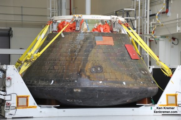
Homecoming view of NASA’s first Orion spacecraft after returning to NASA’s Kennedy Space Center in Florida on Dec. 19, 2014 after successful blastoff on Dec. 5, 2014.  Credit: Ken Kremer - kenkremer.com
Homecoming view of NASA’s first Orion spacecraft after returning to NASA’s Kennedy Space Center in Florida on Dec. 19, 2014 after successful blastoff on Dec. 5, 2014. Credit: Ken Kremer – kenkremer.com

Stay tuned here for Ken’s continuing Earth and planetary science and human spaceflight news.

Ken Kremer

This is a Scale Model of the Solar System Like You’ve Never Seen Before

Five friends traveled to a dry lake bed in Nevada to create an accurate scale model of the planets' orbits. (Screenshot) © Wylie Overstreet and Alex Gorosh

We’ve all seen illustrations of the Solar System. They’re in our school textbooks, on posters, on websites, on t-shirts… in some cases they’re used to represent the word “science” itself (and for good reason.) But, for the most part, they’re all wrong. At least where scale is concerned.

Sure, you can show the Sun and planets in relative size to each other accurately. But then the actual distances between them will probably be way off.* And OK, you can outline the planets’ concentric orbits around the Sun to scale pretty easily. But then there’s no convenient way to make sure that the planets themselves would actually be visible. In order to achieve both, you have to leave the realm of convenience behind entirely and make a physical model that, were you to start with an Earth the size of a marble, would stretch for several miles (and that’s not even taking Pluto into consideration.)

This is exactly what filmmaker Wylie Overstreet and four of his friends did in 2014, spending a day and a half on a dry lake bed in Nevada where they measured out and set up a scale model of the Sun and planets (not including Pluto, don’t tell Alan Stern) including their respective circular orbits. They then shot time-lapse images of their illuminated cars driving around the orbits. The resulting video is educational, mesmerizing, beautiful, and overall a wonderful demonstration of the staggering scale of space in the Solar System.

Watch the video below:

Or watch full-screen on Vimeo here.

For some reason whenever I think about the sheer amount of space there actually is in space, it gets me a like choked up. These guys get an “A+” for effort, execution, and entertainment!

Credit: Wylie Overstreet and Alex Gorosh

*There have been a few web pages that have been able to show the scale sizes and distances of the planets (and there are even some driving-distance ones too) but often they oversimplify by lining the planets up in a row — which doesn’t happen all that often and doesn’t portray the orbital circumferences either. This all just happens to be a favorite contemplating point of mine.

Pluto Spectacular! Glaciers, Hazes, Majestic Peaks Revealed in New Photos

Pluto’s Majestic Mountains, Frozen Plains and Foggy Hazes: Just 15 minutes after its closest approach to Pluto on July 14, 2015, NASA’s New Horizons spacecraft looked back toward the sun and captured this near-sunset view of the rugged, icy mountains and flat ice plains extending to Pluto’s horizon. The smooth expanse of the informally named icy plain Sputnik Planum (right) is flanked to the west (left) by rugged mountains up to 11,000 feet (3,500 meters) high, including the informally named Norgay Montes in the foreground and Hillary Montes on the skyline. To the right, east of Sputnik, rougher terrain is cut by apparent glaciers. The backlighting highlights over a dozen layers of haze in Pluto’s tenuous but distended atmosphere. The image was taken from a distance of 11,000 miles (18,000 kilometers) to Pluto; the scene is 780 miles (1,250 kilometers) wide. Credits: NASA/JHUAPL/SwRI

As the hazy, lazy days of summer come to a close, the New Horizons team released a brand new set of incredible images of a very atmospheric Pluto.

Can you believe the detail in these photos? Back-lit by the Sun, we see icy plains, rugged mountains, glacier-cut terrain and multiple layers of haze just like those on a steamy August afternoon.

Closer Look: Majestic Mountains and Frozen Plains: Just 15 minutes after its closest approach to Pluto on July 14, 2015, NASA’s New Horizons spacecraft looked back toward the sun and captured this near-sunset view of the rugged, icy mountains and flat ice plains extending to Pluto’s horizon. The smooth expanse of the informally named Sputnik Planum (right) is flanked to the west (left) by rugged mountains up to 11,000 feet (3,500 meters) high, including the informally named Norgay Montes in the foreground and Hillary Montes on the skyline. The backlighting highlights more than a dozen layers of haze in Pluto’s tenuous but distended atmosphere. The image was taken from a distance of 11,000 miles (18,000 kilometers) to Pluto; the scene is 230 miles (380 kilometers) across. Credits: NASA/JHUAPL/SwRI)
Just look at those pyramidal mountain peaks right next to those relatively smooth, icy plains. The backlighting highlights more than a dozen layers of haze in Pluto’s tenuous but distended atmosphere. The image was taken from a distance of 11,000 miles (18,000 km) to Pluto; the scene is 230 miles (380 km) across.
Credits: NASA/JHUAPL/SwRI)

The scene measures 780 miles (1,250 kilometers) across and was taken from a distance of 11,000 miles (18,000 km) on July 15 just after closest approach. Because backlighting highlights fine aerosols suspended in the atmosphere (think of seeing your breath on a cold winter day against the Sun), these photos show the amazing complexity of Pluto’s atmosphere with more than a dozen thin haze layers extending from near the ground to at least 60 miles (100 km) above the surface.

Near-Surface Haze or Fog on Pluto: In this small section of the larger crescent image of Pluto, taken by NASA’s New Horizons just 15 minutes after the spacecraft’s closest approach on July 14, 2015, the setting sun illuminates a fog or near-surface haze, which is cut by the parallel shadows of many local hills and small mountains. The image was taken from a distance of 11,000 miles (18,000 kilometers), and the width of the image is 115 miles (185 kilometers). Credits: NASA/JHUAPL/SwRI
 In this small section of the larger crescent image of Pluto, the setting sun illuminates a bank of fog or low-lying near-surface haze sliced by the parallel shadows of many local hills and small mountains. The image was taken from a distance of 11,000 miles (18,000 km), and the width of the image is 115 miles (185 km).
Credits: NASA/JHUAPL/SwRI

“This image really makes you feel you are there, at Pluto, surveying the landscape for yourself,” said New Horizons Principal Investigator Alan Stern in a press release today. “But this image is also a scientific bonanza, revealing new details about Pluto’s atmosphere, mountains, glaciers and plains.”

Sputnik Planum is the informal name of the smooth, light-bulb shaped region on the left of this composite of several New Horizons images of Pluto. The brilliantly white upland region to the right may be coated by nitrogen ice that has been transported through the atmosphere from the surface of Sputnik Planum, and deposited on these uplands. The box shows the location of the glacier detail images below. Credits: NASA/JHUAPL/SwRI
Sputnik Planum is the informal name of the smooth, light-bulb shaped region on the left of this composite of several New Horizons images of Pluto. The brilliantly white upland region to the right may be coated by nitrogen ice that has been transported through the atmosphere from the surface of Sputnik Planum, and deposited on these uplands. The box shows the location of the glacier detail images below.
Credits: NASA/JHUAPL/SwRI

I find the hazes the most amazing aspect of the photos. They remind me of crepuscular rays, those beams of sunshine that shine between breaks in the clouds near sunset and sunrise. It chills and thrills me to the bone to see such earthly sights on a bitterly cold orb more than 3 billion miles from home.

Ice, probably frozen nitrogen, appears to have accumulated on the uplands on the right side of this 390-mile (630-km) wide image is draining from Pluto’s mountains onto the informally named Sputnik Planum through the 2- to 5-mile (3- to 8-km) wide valleys indicated by the red arrows. On Earth this would be considered a valley glacier. The flow front of the ice moving into Sputnik Planum is outlined by the blue arrows. The origin of the ridges and pits on the right side of the image remains uncertain. Credits: NASA/JHUAPL/SwRI
Ice, probably frozen nitrogen, appears to have accumulated on the uplands on the right side of this 390-mile (630-km) wide image is draining from Pluto’s mountains onto the informally named Sputnik Planum through the 2- to 5-mile (3- to 8-km) wide valleys indicated by the red arrows. On Earth this would be considered a valley glacier. The flow front of the ice moving into Sputnik Planum is outlined by the blue arrows. The origin of the ridges and pits on the right side of the image remains uncertain.
Credits: NASA/JHUAPL/SwRI

But that’s not all that’s close to our hearts on Pluto. The photos reveal nitrogen ice apparently flowing downhill from mountainous highlands into a broad, smooth basin. Combined with other recently downloaded pictures, this new image (above) provides evidence for a remarkably Earth-like “hydrological” cycle on Pluto – but involving soft and exotic ices, including nitrogen, rather than water ice.

This might be the most remarkable image of all. Intricate Valley Glaciers on Pluto: This image covers the same region as the image above, but is re-projected from the oblique, backlit view shown in the new crescent image of Pluto. The backlighting highlights the intricate flow lines on the glaciers. The flow front of the ice moving into the informally named Sputnik Planum is outlined by the blue arrows. The origin of the ridges and pits on the right side of the image remains uncertain. This image is 390 miles (630 kilometers) across. Credits: NASA/JHUAPL/SwRI
This might be the most remarkable image of all. It covers the same region as the image above, but is re-projected from the oblique, backlit view shown in the new crescent image of Pluto. The backlighting highlights the intricate flow lines on the valley glaciers. The flow front of the ice moving into the informally named Sputnik Planum is outlined by the blue arrows. We’re looking at a scene 390 miles (630 km) across.
Credits: NASA/JHUAPL/SwRI

Nitrogen ice in the vast, relatively smooth Sputnik Planum may have vaporized in sunlight and then redeposited as ice in the bright, rugged region to its east. The new Ralph imager panorama also reveals glaciers flowing back from the blanketed mountain region into Sputnik Planum; these features are similar to the frozen streams on the margins of ice caps on Greenland and Antarctica.

Who knew that by going to Pluto we’d see such familiarity? But there you have it.

Construction of Crew Access Tower Starts at Atlas V Pad for Boeing ‘Starliner’ Taxi to ISS

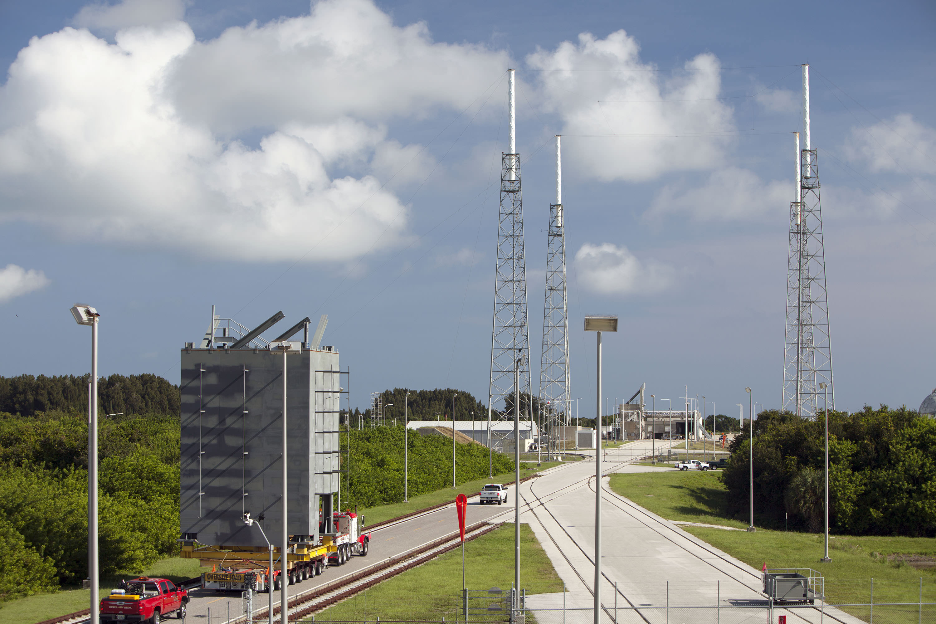
The first tier of seven tiers for Crew Access Tower is moved from its construction yard to Space Launch Complex-41 at Cape Canaveral Air Force Station in Florida. The tower will provide access at the pad for astronauts and ground support teams to the Boeing CST-100 Starliner launching atop a United Launch Alliance Atlas V rocket. Photo credit: NASA/Dmitrios Gerondidakis

The first tier of seven tiers for Crew Access Tower is moved from its construction yard to Space Launch Complex-41 at Cape Canaveral Air Force Station in Florida on Sept 9, 2015. The tower will provide access at the pad for astronauts and ground support teams to the Boeing CST-100 Starliner launching atop a United Launch Alliance Atlas V rocket. Photo credit: NASA/Dmitrios Gerondidakis
Story/photos updated[/caption]

KENNEDY SPACE CENTER, FL – Restoring America’s human path back to space from US soil kicks into high gear at last as construction starts on erecting the new crew access tower on the Atlas V launch pad that will soon propel Americans astronauts riding aboard the commercially developed Boeing CST-100 ‘Starliner’ taxi to the Earth-orbiting International Space Station (ISS).

The last hurdle to begin stacking the crew access tower at the United Launch Alliance Atlas V complex-41 launch pad on Cape Canaveral Air Force Station, Florida was cleared with the magnificent predawn blastoff of the U.S. Navy’s MUOS-4 communications satellite on Sept. 2 – following a two day weather delay due to Tropical Storm Erika.

“Everything is on schedule,” Howard Biegler, ULA’s Human Launch Services Lead, told Universe Today during an exclusive interview. “The new 200-foot-tall tower structure goes up rather quickly at launch pad 41.”

The access tower essentially functions as the astronauts walkway to the stars.

“We start stacking the crew access tower [CAT] after the MUOS-4 launch and prior to the next launch after that of Morelos-3,” Beigler said in a wide ranging interview describing the intricately planned pad modifications and tower construction at the Atlas V Space Launch Complex 41 facility at Cape Canaveral.

Depending on the always tricky weather at the Cape, more than half the tower should be “installed prior to MORELOS-3’s launch on Oct. 2. The balance of the CAT will take form after the launch.”

The first tier of the new Crew Access Tower for the Boeing CST-100 Starliner arrives at Space Launch Complex-41 at Cape Canaveral Air Force Station in Florida.   The tower will provide access at the pad for astronauts and ground support teams  to the Boeing CST-100 Starliner launching atop a United Launch Alliance Atlas V rocket.   Photo credit: NASA/Dmitrios Gerondidakis
The first tier of the new Crew Access Tower for the Boeing CST-100 Starliner arrives at Space Launch Complex-41 at Cape Canaveral Air Force Station in Florida on Sept 9, 2015. The tower will provide access at the pad for astronauts and ground support teams to the Boeing CST-100 Starliner launching atop a United Launch Alliance Atlas V rocket. Photo credit: NASA/Dmitrios Gerondidakis

The crew access tower is a critical space infrastructure element and absolutely essential for getting Americans back to space on American rockets for the first time since NASA’s shuttles were retired in 2011. That action forced our total dependence on the Russian Soyuz capsule for astronaut rides to the space station.

Boeing was awarded a $4.2 Billion contract in September 2014 by NASA Administrator Charles Bolden to complete development and manufacture of the CST-100 space taxi under the agency’s Commercial Crew Transportation Capability (CCtCap) program and NASA’s Launch America initiative. SpaceX also received a NASA award worth $2.6 Billion to build the Crew Dragon spacecraft for launch atop the firms man-rated Falcon 9 rocket.

Starliner is a key part of NASA’s overarching strategy to send Humans on a “Journey to Mars” in the 2030s.

The tower is of modular design for ease of assembly at the always busy Atlas launch pad.

“The crew tower is comprised of seven major tiers, or segments,” Beigler explained. “The building of the tiers went right on schedule. Each tier is about 20 feet square and 28 feet tall.”

Five of the seven tiers will be installed ahead of the next Atlas launch in early October, depending on the weather which has been difficult at the Cape.

“Our plan is to get 5 tiers and a temporary roof installed prior to MORELOS-3’s launch on October 2.”

“We have been hit hard with weather and are hopeful we can gain some schedule through the weekend. The balance of the CAT will take form after the 10/2 launch with the 7th tier planned to go up on 10/13 and roof on 10/15,” Biegler explained.

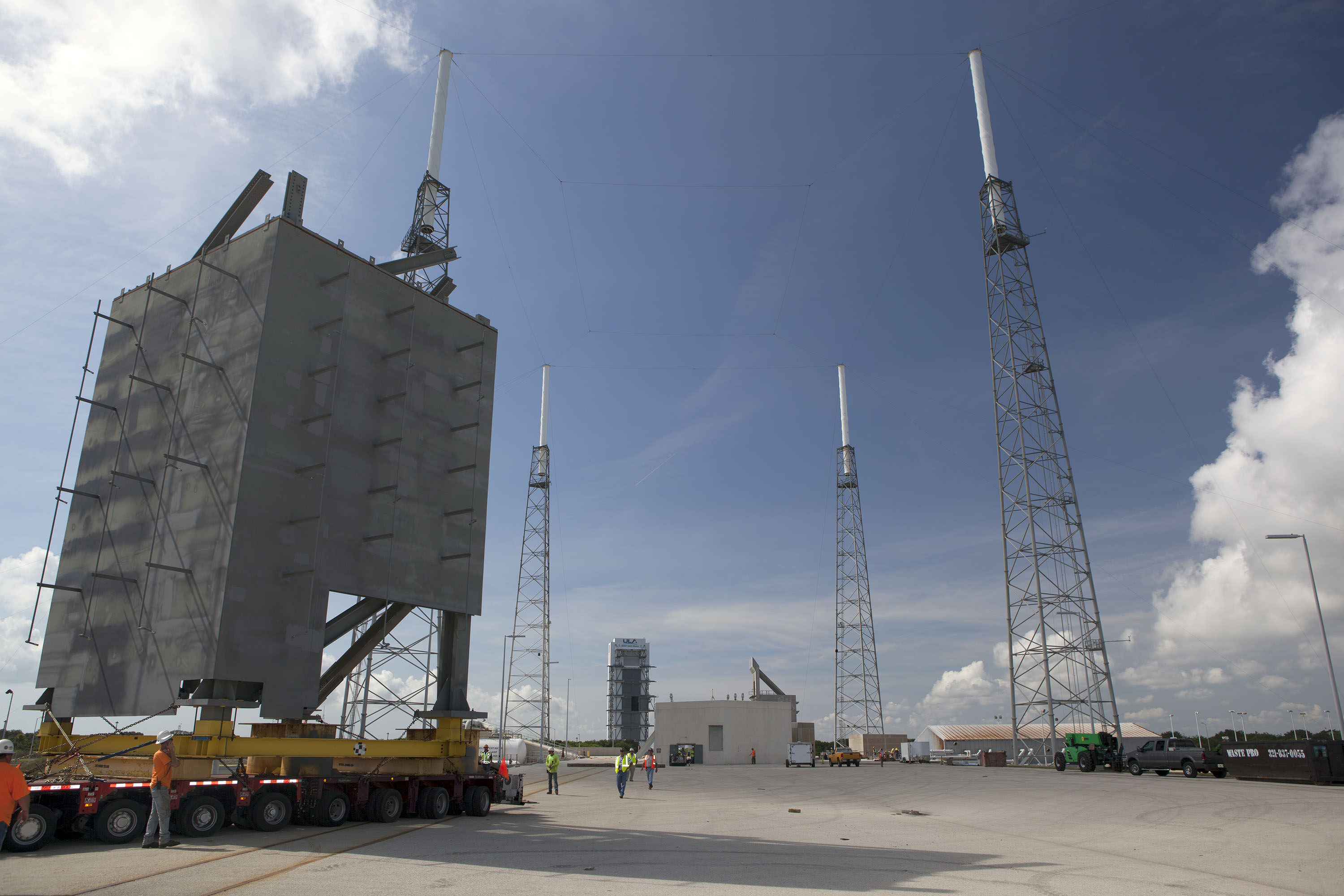
The first tier of the new Crew Access Tower for the Boeing CST-100 Starliner is installed at Space Launch Complex-41 at Cape Canaveral Air Force Station in Florida on Sept 9, 2015 where United Launch Alliance  Atlas V rockets will lift Boeing Starliners into orbit.  Photo credit: NASA/Dmitrios Gerondidakis
The first tier of the new Crew Access Tower for the Boeing CST-100 Starliner is installed at Space Launch Complex-41 at Cape Canaveral Air Force Station in Florida where United Launch Alliance Atlas V rockets will lift Boeing Starliners into orbit. Photo credit: NASA/Dmitrios Gerondidakis

The newly named ‘Starliner’ space taxi will launch atop a newly human-rated Atlas V booster as soon as mid-2017, say NASA, ULA and Boeing officials.

But before astronauts can even climb aboard Starliner atop the Atlas rocket, ULA and Boeing first had to design, build and install a brand new tower providing access to the capsule for the crews and technicians.

Pad 41 is currently a “clean pad” with no gantry and no walkway to ‘Starliner’ because the Atlas V has only been used for unmanned missions to date.

The CST-100 ‘Starliner’ is at the forefront of ushering in the new commercial era of space flight and will completely revolutionize how we access, explore and exploit space for the benefit of all mankind.

This is the first new Crew Access Tower to be built at the Cape in decades, going back to NASA’s heyday and the Apollo moon landing era.

The tier segments were assembled about four miles down the road at the Atlas Space Operations Center on Cape Canaveral – so as not to disrupt the chock full manifest of Atlas rockets launching on a breakneck schedule for the NASA, military and commercial customers who ultimately pay the bills to keep ULA afloat and launch groundbreaking science probes and the most critical national security payloads vital to national defense.

“Each segment was outfitted with additional steel work, as well as electrical, plumbing and the staircase. Then they will be transported 3.9 miles out to the pad, one at a time on a gold hoffer and then we start erecting.”

The first two tiers were just transported out to pad 41. Installation and stacking of one tier on top of another starts in a few days.

Artist’s concept of Boeing’s CST-100 space taxi atop a human rated ULA Atlas-V rocket showing new crew access tower and arm at Space Launch Complex 41, Cape Canaveral Air Force Station, Fl. Credit: ULA/Boeing

“We are very pleased with the progress so far,” Biegler told me. “Everything is on schedule and has gone remarkably well so far. No safety or workmanship issues. It’s all gone very well.”

“The first tier is obviously the most critical [and will take a bit longer than the others to insure that everything is being done correctly]. It has to be aligned precisely over the anchor bolts on the foundation at the pad. Then it gets bolted in place.”

“After that they can be installed every couple of days, maybe every three days or so. The pieces of the tower will go up quickly.”

Artist’s concept of Boeing’s CST-100 space taxi atop a human rated ULA Atlas-V rocket showing new crew access tower and arm. Credit: ULA/Boeing
The steel tiers and tower are being built by Hensel Phelps under contract to ULA.

“Construction by the Hensel Phelps team started in January 2015,” Biegler said.

Erecting the entire tower is the next step. After stacking the tiers is fully completed later this year then comes structure, testing and calibration work over the next year.

“After tower buildup comes extensive work to outfit the tower with over 400 pieces of outboard steel that have to be installed. That takes much longer,” Biegler said.

“Designed with modern data systems, communications and power networks integrated and protected from blast and vibration, plus an elevator, the Crew Access Tower has been built with several features only a fully suited astronaut could appreciate, such as wider walkways, snag-free railings and corners that are easy to navigate without running into someone,” according to NASA officials.

Just like the shuttle, “the tower will also be equipped with slide wire baskets for emergency evacuation to a staged blast-resistant vehicle.”

“At the very top is the area that protects the access arm and provides the exit location for the emergency egress system. It will all be stick built from steel out at the pad,” Biegler elaborated.

The access arm with the walkway that astronauts will traverse to the Starliner capsule is also under construction. It is about 180 feet above ground.

Astronauts will ride an elevator up the tower to the access arm, and walk through it to the white room at the end to board the Starliner capsule.

“The arm along with the white room and torque tube are being fabricated in Florida. It will all be delivered to the pad sometime around next June [2016],” Biegler stated.

“We built a test stand tower for the access arm at our Oak Hill facility to facilitate the installation process. We mount the arm and the hydraulic drive system and then run it through its paces prior to its delivery to the pad.”

“The access arm – including the torque tube out to the end – is just over 40 feet in length.”

“We will integrate it off line because we don’t have a lot of time to troubleshoot out at the pad. So we will hook up all its drive systems and electronics on the test structure stand.”

“Then we will spend about 3 months testing it and verifying that everything is right. We’ll use laser lining to know it all precisely where the arm is. So that when we bring it out to the pad we will know where it is to within fractions of an inch. Obviously there will be some minor adjustments up and down.”

“That way in the end we will know that everything in the arm and the hydraulic drive system are working within our design specs.”

When the arm is finally installed on the crew access tower it will be complete, with the white room and environmental seal already attached.

“It will stow under the crew access tower, which is located west and north of the launch vehicle. The arm will swing out about 120 degrees to the crew module to gain access and was strategically picked to best fit the features and foundation at the existing pad structure.”

Tower construction takes place in between Atlas launches and pauses in the days prior to launches. For example the construction team will stand down briefly just ahead of the next Atlas V launch currently slated for Oct. 2 with the Mexican governments Morelos-3 communications satellite.

MUOS-4 US Navy communications satellite and Atlas V rocket at pad 41 at Cape Canaveral Air Force Station, FL for launch on Sept. 2, 2015 at 5:59 a.m. EDT. Credit: Ken Kremer/kenkremer.com
The Crew Access Tower is now being erected at Pad 41 following MUOS-4 blastoff here. MUOS-4 US Navy communications satellite and Atlas V rocket at pad 41 at Cape Canaveral Air Force Station, FL for launch on Sept. 2, 2015 at 5:59 a.m. EDT. Credit: Ken Kremer/kenkremer.com

Starliners’ actual launch date totally depends on whether the US Congress provides full funding for NASA’s commercial crew program (CCP).

Thus far the Congress has totally failed at providing the requested CCP budget to adequately fund the program – already causing a 2 year delay of the first flight from 2015 to 2017.

Boeing is making great progress on manufacturing the first CST-100 Starliner.

Barely a week ago, Boeing staged the official ‘Grand Opening’ ceremony for the craft’s manufacturing facility held at the Kennedy Space Center on Friday, Sept 4. 2015 – attended by Universe Today as I reported here.

ULA has also already started assembly of the first two Atlas V rockets designated for Starliner at their rocket factory in Decatur, Alabama.

Read my earlier exclusive, in depth one-on-one interviews with Chris Ferguson – America’s last shuttle commander, who now leads Boeings’ CST-100 program; here and here.

First view of the Boeing CST-100 'Starliner' crewed space taxi at the Sept. 4, 2015 Grand Opening ceremony held in the totally refurbished C3PF manufacturing facility at NASA's Kennedy Space Center. These are the upper and lower segments of the first Starliner crew module known as the Structural Test Article (STA) being built at Boeing’s Commercial Crew and Cargo Processing Facility (C3PF) at KSC. Credit: Ken Kremer /kenkremer.com
First view of the Boeing CST-100 ‘Starliner’ crewed space taxi at the Sept. 4, 2015 Grand Opening ceremony held in the totally refurbished C3PF manufacturing facility at NASA’s Kennedy Space Center. These are the upper and lower segments of the first Starliner crew module known as the Structural Test Article (STA) being built at Boeing’s Commercial Crew and Cargo Processing Facility (C3PF) at KSC. Credit: Ken Kremer /kenkremer.com

Stay tuned here for Ken’s continuing Earth and planetary science and human spaceflight news.

Ken Kremer

10 Years of Haumea

Credit to Harvard-Smithsonian CfA

Remember the neat tidy solar system of the 20th century? As a child of the 1970s, we remember orderly planets, with circular orbits punctuated by the occasional asteroid or comet. They say ignorance is bliss, and the modern astronomical age of discovery in the 21st century has since revealed a cosmic terra incognita in our solar backyard.

We’re talking about the 99% of the solar system by volume out beyond the orbit Neptune, occupied by Trans-Neptunian Objects (TNO), Plutinos (the object, not the drink), Kuiper Belt Objects (KBOs) and more.

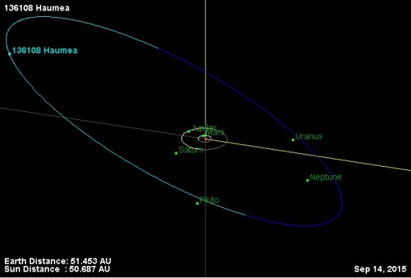
136108 Haumea — one of the strangest worlds of them all — was introduced into the solar system menagerie about ten years ago. Discovered by Mike Brown (@Plutokiller extraordinaire) and team in late December 2004 from the Palomar Observatory, Haumea (say HOW-meh) received its formal name on September 17, 2008 along with its dwarf planet designation. Remember, astronomers discovered Haumea — like Xena turned Eris — before the series of decisions by the International Astronomical Union in 2006 which led to the Pluto is a planet/is a dwarf planet/ is a Plutoid roller coaster ride.

Image credit: JPL
The orbit of 136108 Haumea. Image credit: NASA/JPL

You’ve come a long way, little ice world, as New Horizons has finally given us a view of Pluto and friends just this past summer. Thankfully, most of us weren’t on Twitter yet back in 2006…  heck, you can even read the original article by Universe Today  from around the time of Eris and Haumea’s discovery (really: we’ve been around that long!)

It wasn’t long before Brown and team realized they had a strange discovery on their hands, as well as a lingering controversy. First, a team from the Sierra Nevada Observatory in Spain attempted to scoop the Palomar team concerning the discovery. It was later learned that the Sierra Nevada team was accessing the Caltech logs remotely, and looking at where the telescopes were hunting in the sky, and at what times. Though the Spanish team later conceded accessing the observation logs, they maintained that they were double-checking earlier observations of the subject object from 2003. Wherever you stand on the discovery hullabaloo, Mike Brown goes into depth on the modern astronomical controversy in his book How I Killed Pluto and Why it Had it Coming.

Image credit: ESA
Haumea (the ‘egg’ to the lower left) versus ESA Herschel’s population of Trans-Neptunian Objects Image credit: ESA/Herschel/PACS/SPIRE

Haumea initially earned the nickname ‘Santa Claus’ due to its discovery near the Christmas holiday. Haumea derives its formal name from the Hawaiian goddess of childbirth. Likewise, the reindeer inspired moons Rudolph and Blitzen were later named Hi’aka and Namaka after daughters of Haumea in the Hawaiian pantheon.   Brown at team discovered both moons shortly after Haumea itself.

A Bizarre World

Methone_PIA14633
Saturn’s moon Methone… a possible ‘mini-twin’ of Haumea? Image credit: NASA/JPL-Caltech/Space Science Institute

The Bizzaro homeworld of Superman mythos has nothing on Haumea. OK, maybe it’s not a perfect cube — remember, nothing’s perfect on the Bizzaro planet either — but it does have a decidedly oblate egg shape.   Haumea is a fast rotator, with a ‘day’ equal to about four hours. We know this due to periodic changes in brightness. Haumea also has a high albedo of about 80%, similar to freshly fallen snow.

Models suggest that Haumea is about twice as long as it is wide, with dimensions of 2,000 kilometres along its long axis, versus 1,000 kilometres through its poles. The presence of two tiny moons allows us to estimate its mass at about 33% of Pluto, and 6% that of Earth’s Moon. With such a fast rotation, Haumea must just be barely maintaining hydrostatic equilibrium, though it’s stretching the world to its max.

Image credit:
Haumea and friends: orbital inclinations of TNO/KBO families vs AU distance. Image credit: Wikimedia/Eurocommuter

Evidence of an ancient collision, perhaps? It would be fascinating to see Haumea up close. Like Pluto, however, it’s distant, with an aphelion near 51.5 AU and a perihelion near 35 AU. Orbiting the Sun once every 284 years, Haumea just passed aphelion in 1992 about a decade prior to discovery, and perhaps the time to send a New Horizons-type mission past it would be near perihelion in 2134.  Interestingly, Haumea is also in a near 7:12 resonance with Neptune, meaning it completes 7 orbits around the Sun to Neptune’s 12.

Image credit: Starry Night Education Software
The outer solar system view from Haumea. Image credit: Starry Night Education Software

A Swift Sky

Astronomy from Haumea is literally dizzying to contemplate.  First, prepare yourself for that four hour day: you would easily see the rotation of the sky — to the tune of an object rising and reaching the zenith in just an hour — moving in real time. Then there’s the two moons Namaka and Hi’iaka, in 18 and 50 day orbits, respectively… both would show discernible discs and phases courtesy of the Sun, which would currently present a  38” disk shining at magnitude -18 (still about 100 times brighter than a Full Moon). Looking for Earth? It’s an easy catch at magnitude +4.8 but never strays more than 1 degree from the Sun, twice the diameter of a Full Moon.

Image credit: Starry Night Education Software
An inner solar system view from Haumea. the green circle is twice the size of a Full Moon. Image credit: Starry Night Education Software

Haumea currently shines at magnitude +17 in the constellation Boötes. Theoretically, it’s within the grab of a large amateur telescope, though to our knowledge, no backyard observer has ever manage to nab it… perhaps this will change over the next century or so towards perihelion?

Scratch that… we’ve since learned that Mike Weasner did indeed nab Haumea in 2013 from his backyard Cassiopeia observatory near Oracle, Arizona:

Image credit:
A capture of Haumea… with an 8″ telescope! The brilliant star in the frame is magnitude +2.7 Eta Boötis (Murphid). Image credit: Mike Weasner/Cassiopeia observatory

Awesome!

The discovery of Haumea and friends is a fascinating tale of modern astronomy, and shows us just how strange the brave new worlds of the outer solar system are. Perhaps one day, human eyes will gaze at the bizarre skies of Haumea… though keeping a telescope tracking might be a true challenge!