T-Minus 12 Days to Perihelion, Rosetta’s Comet Up Close and in 3D

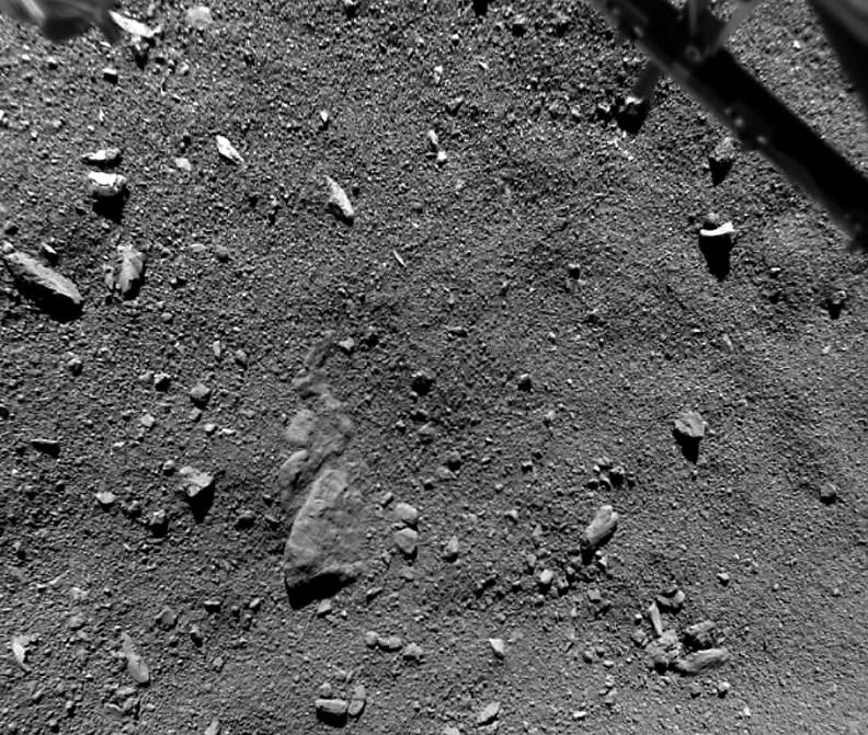
We've never seen a comet as close as this. Taken shortly before touchdown by the Philae lander on November 12, 2014, you're looking across a scene just 32 feet from side to side (9.7-meters) or about the size of a living room. Part of the lander is visible at upper right. Credit: ESA/Rosetta/Philae/ROLIS/DLR

With just 12 days before Comet 67P/Churyumov-Gerasimenko reaches perihelion, we get a look at recent images and results released by the European Space Agency from the Philae lander along with spectacular 3D photos from Rosetta’s high resolution camera. 
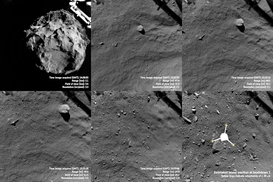
Slow animation of images taken by Philae’s Rosetta Lander Imaging System, ROLIS, trace the lander’s descent to the first landing site, Agilkia, on Comet 67P/Churyumov–Gerasimenko on November 12, 2014. Credits: ESA/Rosetta/Philae/ROLIS/DLR
Slow animation of images taken by Philae’s Rosetta Lander Imaging System, ROLIS, trace the lander’s descent to the first landing site, Agilkia, on Comet 67P/Churyumov–Gerasimenko on November 12, 2014.
Credits: ESA/Rosetta/Philae/ROLIS/DLR

Remarkably, some 80% of the first science sequence was completed in the 64 hours before Philae fell into hibernation. Although unintentional, the failed landing attempt led to the unexpected bonus of getting data from two collection sites — the planned touchdown at Agilkia and its current precarious location at Abydos.

After first touching down, Philae was able to use its gas-sniffing Ptolemy and COSAC instruments to determine the makeup of the comet’s atmosphere and surface materials. COSAC analyzed samples that entered tubes at the bottom of the lander and found ice-poor dust grains that were rich in organic compounds containing carbon and nitrogen. It found 16 in all including methyl isocyanate, acetone, propionaldehyde and acetamide that had never been seen in comets before.

While you and I may not be familiar with some of these organics, their complexity hints that even in the deep cold and radiation-saturated no man’s land of outer space, a rich assortment of organic materials can evolve. Colliding with Earth during its early history, comets may have delivered chemicals essential for the evolution of life.
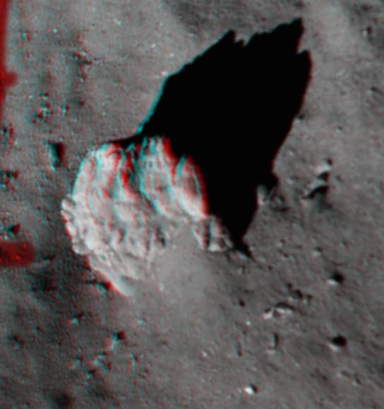
This 3D image focuses on the largest boulder seen in the image captured 221 feet (67.4 m) above Comet 67P/Churyumov–Gerasimenko looks best in a pair of red-blue 3D glasses. Many fractures, along with a tapered ‘tail’ of debris and excavated ‘moat’ around the 5 m-high boulder, are plain to see. Credit: ESA/Rosetta/Philae/ROLIS/DLR

Ptolemy sampled the atmosphere entering tubes at the top of the lander and identified water vapor, carbon monoxide and carbon dioxide, along with smaller amounts of carbon-bearing organic compounds, including formaldehyde. Some of these juicy organic delights have long been thought to have played a role in life’s origins. Formaldehyde reacts with other commonly available materials to form complex sugars like ribose which forms the backbone of RNA and is related to the sugar deoxyribose, the “D” in DNA.

ROLIS (Rosetta Lander Imaging System) images taken shortly before the first touchdown revealed a surface of 3-foot-wide (meter-size) irregular-shaped blocks and coarse “soil” or regolith covered in “pebbles” 4-20 inches (10–50 cm) across as well as a mix of smaller debris.
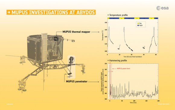
Philae used its thermal sensor to measure daily highs and lows on the comet (top graph). The bottom graph shows time vs. depth when Philae used its penetrator to hammer into the soil. Credit: Spacecraft graphic: ESA/ATG medialab; data from Spohn et al (2015)

Agilkia’s regolith, the name given to the rocky soil of other planets, moons, comets and asteroids, is thought to extend to a depth of about 6 feet (2 meters) in places, but seems to be free from fine-grained dust deposits at the resolution of the images. The 16-foot-high boulder in the photo above has been heavily fractured by some type of erosional process, possibly a heating and cooling cycle that vaporized a portion of its ice. Dust from elsewhere on the comet has been transported to the boulder’s base. This appears to happen over much of 67P/C-G as jets shoot gas and dust into the coma, some of which then settles out across the comet’s surface.

Another suite of instruments called MUPUS used a penetrating “hammer” to reveal a thin layer of dust about an inch thick (~ 3 cm) overlying a much harder, compacted mixture of dust and ice at Abydos. The thermal sensor took the comet’s daily temperature which varies from a high around –229° F (–145ºC) to a nighttime low of about –292° F (–180ºC), in sync with the comet’s 12.4 hour day. The rate at which the temperature rises and falls also indicates a thin layer of dust rests atop a compacted dust-ice crust.
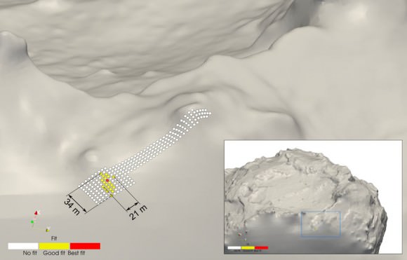
Based on the most recent calculations using CONSERT data and detailed comet shape models, Philae’s location has been revised to an area covering 69 x 112 feet (21 x 34 m). The best fit area is marked in red, a good fit is marked in yellow, with areas on the white strip corresponding to previous estimates now discounted. Credit: ESA/Rosetta/Philae/CONSERT

CONSERT, which passed radio waves through the nucleus between the lander and the orbiter, showed that the small lobe of the comet is a very loosely compacted mixture of dust and ice with a porosity of 75-85%, about that of lightly compacted snow. CONSERT was also used to help triangulate Philae’s location on the surface, nailing it down to an area just 69 x 112 feet ( 21 x 34 m) wide.
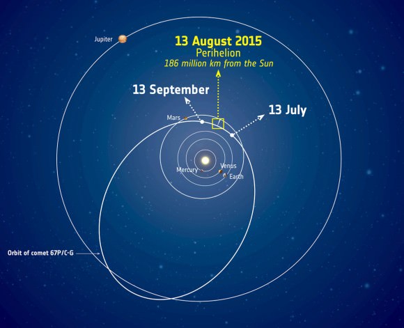
The orbit of Comet 67P/Churyumov–Gerasimenko and its approximate location around perihelion, the closest the comet gets to the Sun. The positions of the planets are correct for August 13, 2015. Copyright: ESA
The orbit of Comet 67P/Churyumov–Gerasimenko and its approximate location around perihelion, the closest the comet gets to the Sun. The positions of the planets are correct for August 13, 2015. The comet will pass closest to Earth in February 2016 at 135.6 million miles but will be brightest this month right around perihelion. Copyright: ESA

In fewer than two weeks, the comet will reach perihelion, its closest approach to the Sun at 116 million miles (186 million km), and the time when it will be most active. Rosetta will continue to monitor 67P C-G from a safe distance to lessen the chance an errant chunk of comet ice or dust might damage its instruments. Otherwise it’s business as usual. Activity will gradually decline after perihelion with Rosetta providing a ringside seat throughout. The best time for viewing the comet from Earth will be mid-month when the Moon is out of the morning sky. Watch for an article with maps and directions soon.

Comet 67P/C-G on July 20, 2015 taken from a distance of 106 miles (171 km) from the comet's center. Rosetta has been keeping a safe distance recently as 67P/C-G approaches perihelion. Credit: ESA/Rosetta/NAVCAM – CC BY-SA IGO 3.0
Comet 67P/C-G on July 20, 2015 taken from a distance of 106 miles (171 km) from the comet’s center. Rosetta has been keeping a safe distance recently as 67P/C-G approaches the August 13th perihelion. Credit: ESA/Rosetta/NAVCAM – CC BY-SA IGO 3.0

“With perihelion fast approaching, we are busy monitoring the comet’s activity from a safe distance and looking for any changes in the surface features, and we hope that Philae will be able to send us complementary reports from its location on the surface,” said Philae lander manager Stephan Ulamec.
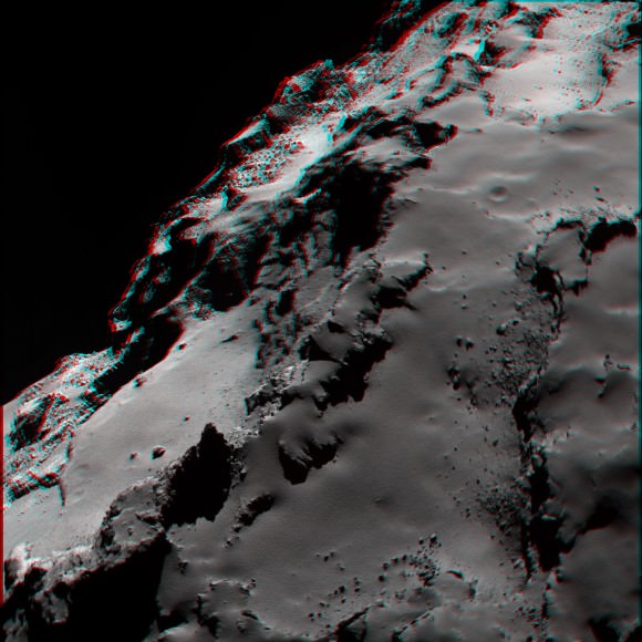
OSIRIS narrow-angle camera image showing the smooth nature of the dust covering the Ash region and highlighting the contrast with the more brittle material exposed underneath in Seth. Credits: ESA/Rosetta/MPS for OSIRIS Team MPS/UPD/LAM/IAA/SSO/INTA/UPM/DASP/IDA
OSIRIS narrow-angle camera image showing the smooth nature of the dust covering the Ash region and highlighting the contrast with the more brittle material exposed underneath in Seth.
Credits: ESA/Rosetta/MPS for OSIRIS Team MPS/UPD/LAM/IAA/SSO/INTA/UPM/DASP/IDA

More about Philae’s findings can be found in the July 31 issue of Science. Before signing off, here are a few detailed, 3D images made with the high-resolution OSIRIS camera on Rosetta. Once you don a pair of red-blue glasses, click the photos for the high-res versions and get your mind blown.

OSIRIS narrow-angle camera mosaic of two images showing an oblique view of the Atum region and its contact with Apis, the flat region in the foreground. This region is rough and pitted, with very few boulders. Credits: ESA/Rosetta/MPS for OSIRIS Team MPS/UPD/LAM/IAA/SSO/INTA/UPM/DASP/IDA
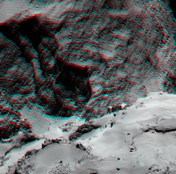
Mosaic of two images showing an oblique view of the Atum region and its contact with Apis, the flat region in the foreground. This region is rough and pitted, with very few boulders.
Credits: ESA/Rosetta/MPS for OSIRIS Team MPS/UPD/LAM/IAA/SSO/INTA/UPM/DASP/IDA
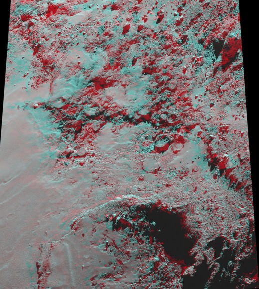
Image highlighting an alcove structure at the Hathor-Anuket boundary on the comet’s small lobe. The layering seen in the alcove could be indicative of the internal structure of the comet. Credits: ESA/Rosetta/MPS for OSIRIS Team MPS/UPD/LAM/IAA/SSO/INTA/UPM/DASP/IDA
Image highlighting an alcove structure at the Hathor-Anuket boundary on the comet’s small lobe. The layering seen in the alcove could be indicative of the internal structure of the comet.
Credits: ESA/Rosetta/MPS for OSIRIS Team MPS/UPD/LAM/IAA/SSO/INTA/UPM/DASP/IDA
Imhotep region in 3D. Credit:
Imhotep region in 3D. Credit: ESA/Rosetta/MPS for OSIRIS Team MPS/UPD/LAM/IAA/SSO/INTA/UPM/DASP/IDA


Curiosity Discovers Mars Rock Like None Before, Sets Drill Campaign

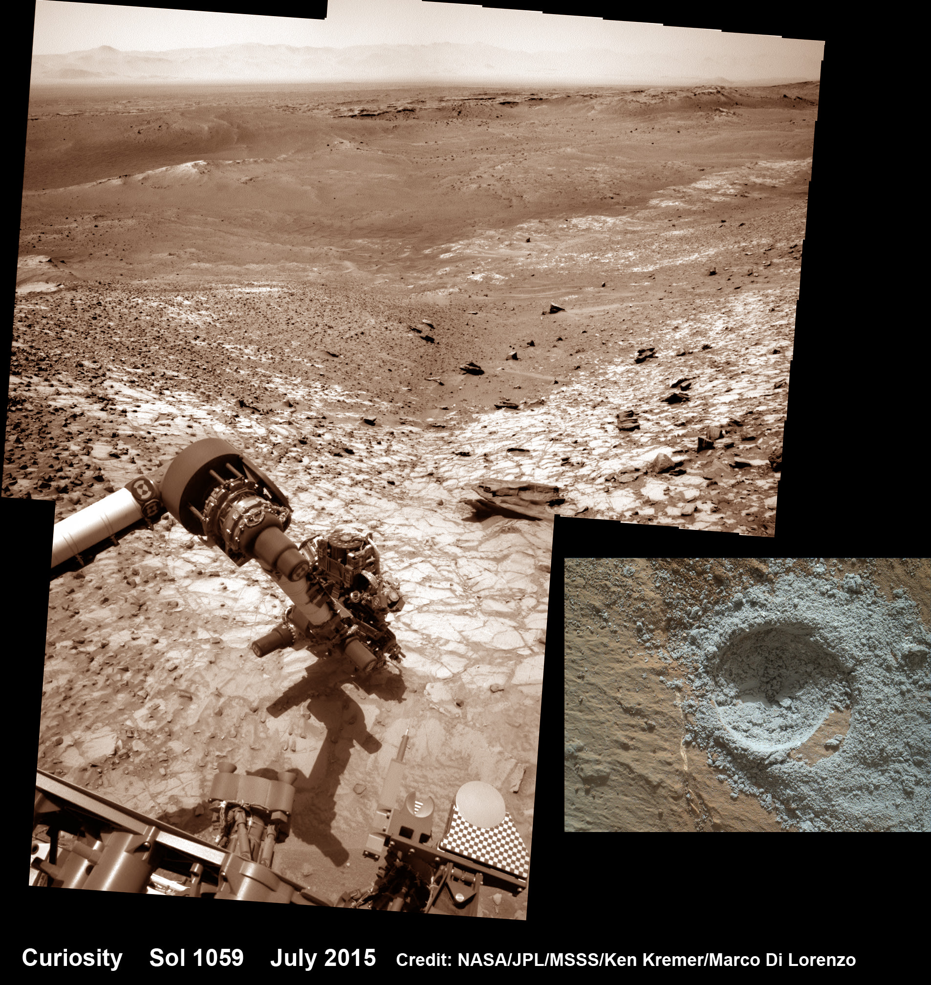
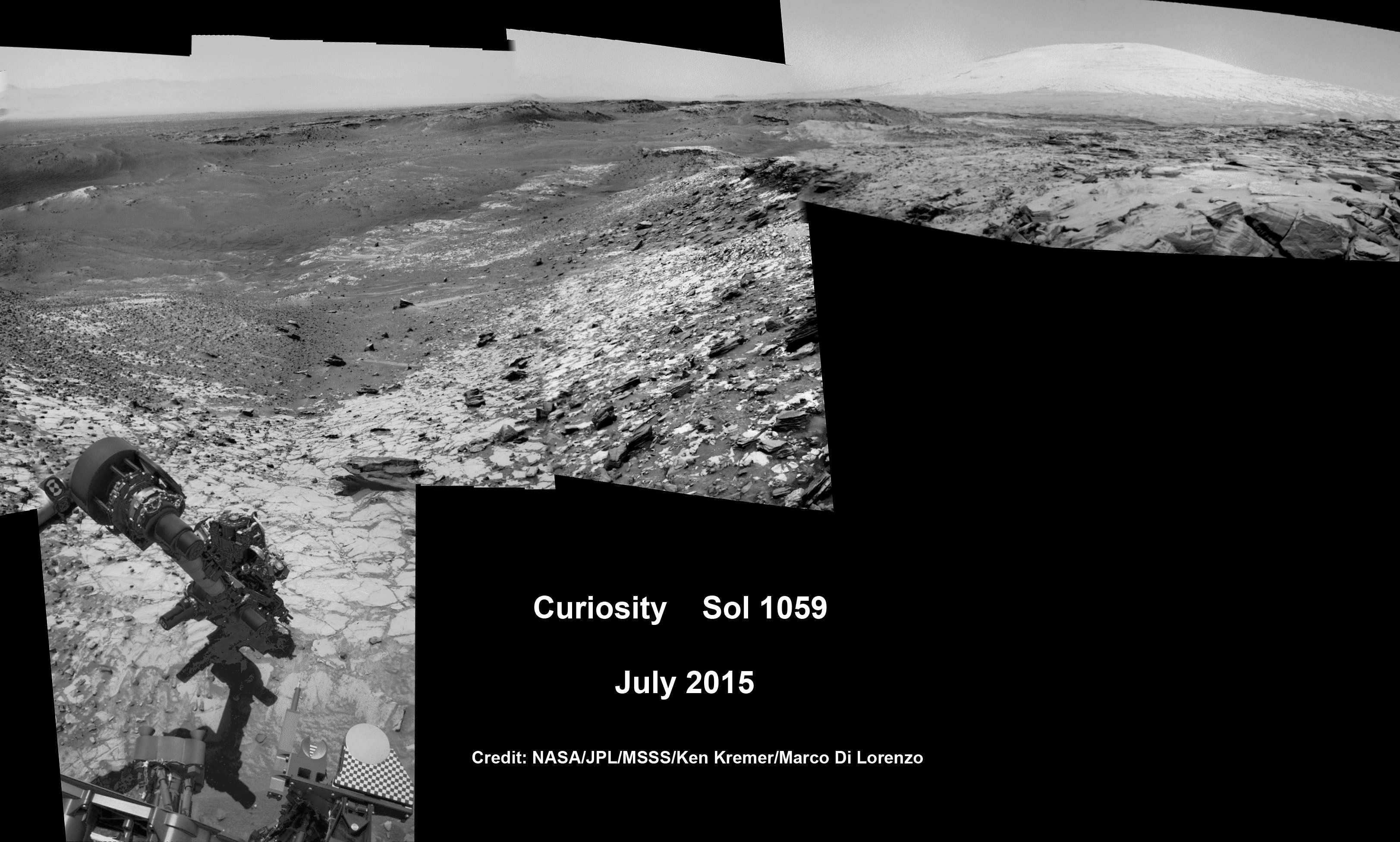
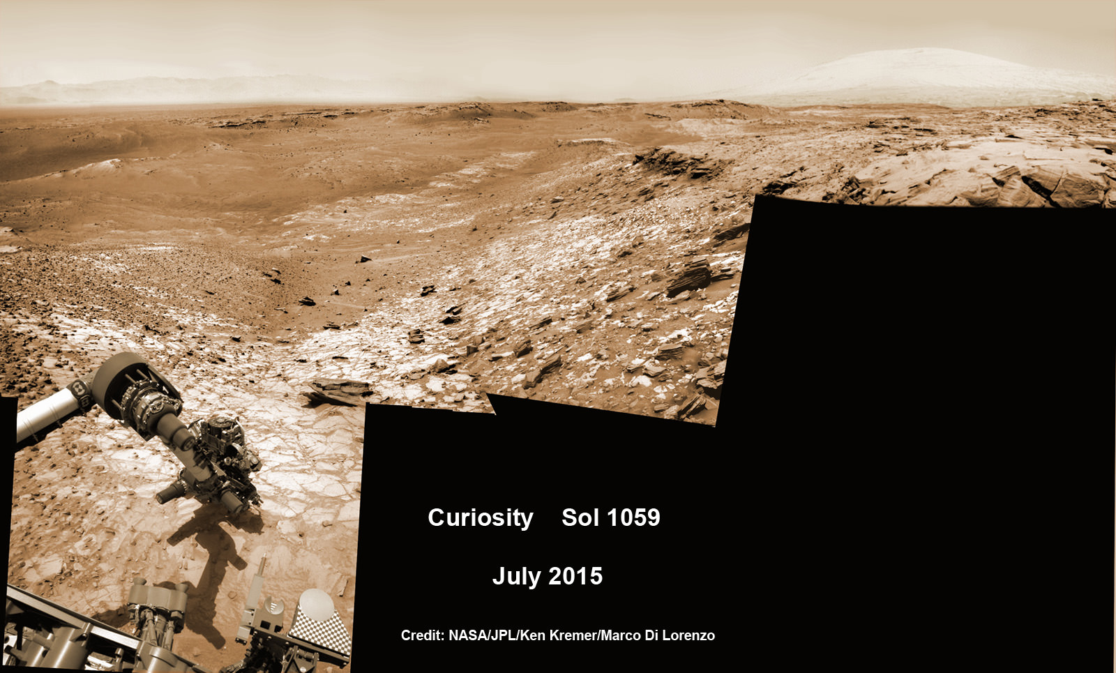
Curiosity extends robotic arm and conducts test drill at “Buckskin” rock target at bright toned “Lion” outcrop on the lower region of Mount Sharp on Mars, seen at right. Gale Crater eroded rim seen in the distant background at left, in this composite multisol mosaic of navcam raw images taken to Sol 1059, July 30, 2015. Navcam camera raw images stitched and colorized. Credit: NASA/JPL-Caltech/Ken Kremer/kenkremer.com/Marco Di Lorenzo

On the eve of the 3rd anniversary since her nail biting touchdown inside Gale Crater, NASA’s car sized Curiosity Mars Science Laboratory (MSL) rover has discovered a new type of Martian rock that’s surprisingly rich in silica – and unlike any other targets found before.

Excited by this new science finding on Mars, Curiosity’s handlers are now gearing the robot up for her next full drill campaign today, July 31 (Sol 1060) into a rock target called “Buckskin” – which lies at the base of Mount Sharp, the huge layered mountain that is the primary science target of this Mars rover mission.

“The team selected the “Buckskin” target to drill,” says Lauren Edgar, Research Geologist at the USGS Astrogeology Science Center and an MSL science team member, in a mission update.

“It’s another exciting day on Mars!”

See the rover at work reaching out with her robotic arm and drilling into Buckskin, as illustrated in our new mosaics of navcam camera images created by the image processing team of Ken Kremer and Marco Di Lorenzo (above and below). Also featured at Alive Universe Images – here.

NASA Curiosity rover inspects ‘Buckskin’ rock outcrop on Mars with APXS mineral spectrometer in this hazcam camera raw image taken on July 29, 2015 (Sol 1058), colorized and linearized.  Credit:  NASA/JPL-Caltech/Marco Di Lorenzo/Ken Kremer/kenkremer.com
NASA Curiosity rover inspects ‘Buckskin’ rock outcrop on Mars with APXS mineral spectrometer in this hazcam camera raw image taken on July 29, 2015 (Sol 1058), colorized and linearized. Credit: NASA/JPL-Caltech/Marco Di Lorenzo/Ken Kremer/kenkremer.com

For about the past two months, the six wheeled robot has been driving around and exploring a geological contact zone named “Marias Pass” – an area on lower Mount Sharp, by examining the rocks and outcrops with her suite of state-of-the-art science instruments.

The goal is to provide geologic context for her long term expedition up the mountains sedimentary layers to study the habitability of the Red Planet over eons of time.

Data from Curiosity’s “laser-firing Chemistry & Camera (ChemCam) and Dynamic Albedo of Neutrons (DAN), show elevated amounts of silicon and hydrogen, respectively,” in certain local area rocks, according to the team.

Silica is a rock-forming compound containing silicon and oxygen, commonly found on Earth as quartz.

“High levels of silica could indicate ideal conditions for preserving ancient organic material, if present, so the science team wants to take a closer look.”

Curiosity conducts test drill at “Buckskin” rock target at bright toned “Lion” outcrop on the lower region of Mount Sharp on Mars.   Gale crater rim seen in the distant background, in this composite mosaic of navcam raw images taken to Sol 1059, July 30, 2015.  Navcam camera raw images stitched and colorized. Credit:  NASA/JPL-Caltech/Ken Kremer/kenkremer.com/Marco Di Lorenzo  Inset: MAHLI camera up close image of  test drill at “Buckskin” rock target.  Credit: NASA/JPL-Caltech/MSSS
Curiosity extends robotic arm and conducts test drill at “Buckskin” rock target at bright toned “Lion” outcrop on the lower region of Mount Sharp on Mars. Gale crater rim seen in the distant background, in this composite mosaic of navcam raw images taken to Sol 1059, July 30, 2015. Inset: MAHLI camera up close image of test drill at “Buckskin” rock target. Navcam camera raw images stitched and colorized. Credit: NASA/JPL-Caltech/Ken Kremer/kenkremer.com/Marco Di Lorenzo Credit: NASA/JPL-Caltech/MSSS

Therefore the team scouted targets suitable for in depth analysis and sample drilling and chose “Buckskin”.

“Buckskin” is located among some high-silica and hydrogen enriched targets at a bright outcrop named “Lion.”

An initial test bore operation was conducted first to confirm whether that it was indeed safe to drill into “Buckskin” and cause no harm to the rover before committing to the entire operation.

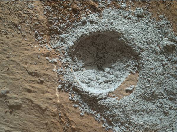
The bore hole is about 1.6 cm (0.63 inch) in diameter.

“This test will drill a small hole in the rock to help determine whether it is safe to go ahead with the full hole,” elaborated Ryan Anderson, planetary scientist at the USGS Astrogeology Science Center and an MSL science team member.

So it was only after the team received back new high resolution imagery last night from the arm-mounted MAHLI camera which confirmed the success of the mini-drill operation, that the “GO” was given for a full depth drill campaign. MAHLI is short for Mars Hand Lens Imager.

“We successfully completed a mini drilling test yesterday (shown in the MAHLI image). That means that today we’re going for the FULL drill hole” Edgar confirmed.

“GO for Drilling.”

So it’s a busy day ahead on the Red Planet, including lots of imaging along the way to document and confirm that the drilling operation proceeds safely and as planned.

“First we’ll acquire MAHLI images of the intended drill site, then we’ll drill, and then we’ll acquire more MAHLI images after drilling,” Edgar explains.

“The plan also includes Navcam imaging of the workspace, and Mastcam imaging of the target and drill bit. In addition to drilling, we’re getting CheMin ready to receive sample in an upcoming plan. Fingers crossed!” Surface observations with the arm-mounted Alpha Particle X-ray Spectrometer (APXS) instrument are also planned.

If all goes well, the robot will process and pulverize the samples for eventual delivery to the onboard pair of miniaturized chemistry labs located inside her belly – SAM and CheMin. Tiny samples will be fed to the inlet ports on the rover deck through the sieved filters.

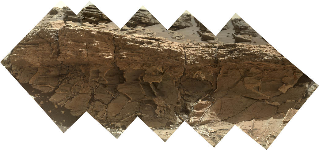
A rock outcrop dubbed "Missoula," near Marias Pass on Mars, is seen in this image mosaic taken by the Mars Hand Lens Imager on NASA's Curiosity rover. Pale mudstone (bottom of outcrop) meets coarser sandstone (top) in this geological contact zone, which has piqued the interest of Mars scientists.   Credit: NASA/JPL-Caltech/MSSS
A rock outcrop dubbed “Missoula,” near Marias Pass on Mars, is seen in this image mosaic taken by the Mars Hand Lens Imager on NASA’s Curiosity rover. Pale mudstone (bottom of outcrop) meets coarser sandstone (top) in this geological contact zone, which has piqued the interest of Mars scientists. Credit: NASA/JPL-Caltech/MSSS

Meanwhile the team is studying a nearby rock outcrop called “Ch-paa-qn” which means “shining peak” in the native Salish language of northern Montana.”

Anderson says the target is a bright patch on a nearby outcrop. Via active and passive observations with the mast-mounted ChemCam laser and Mastcam multispectral imager, the purpose is to determine if “Ch-paa-qn” is comprised of calcium sulfate like other white veins visible nearby, or perhaps it’s something else entirely.

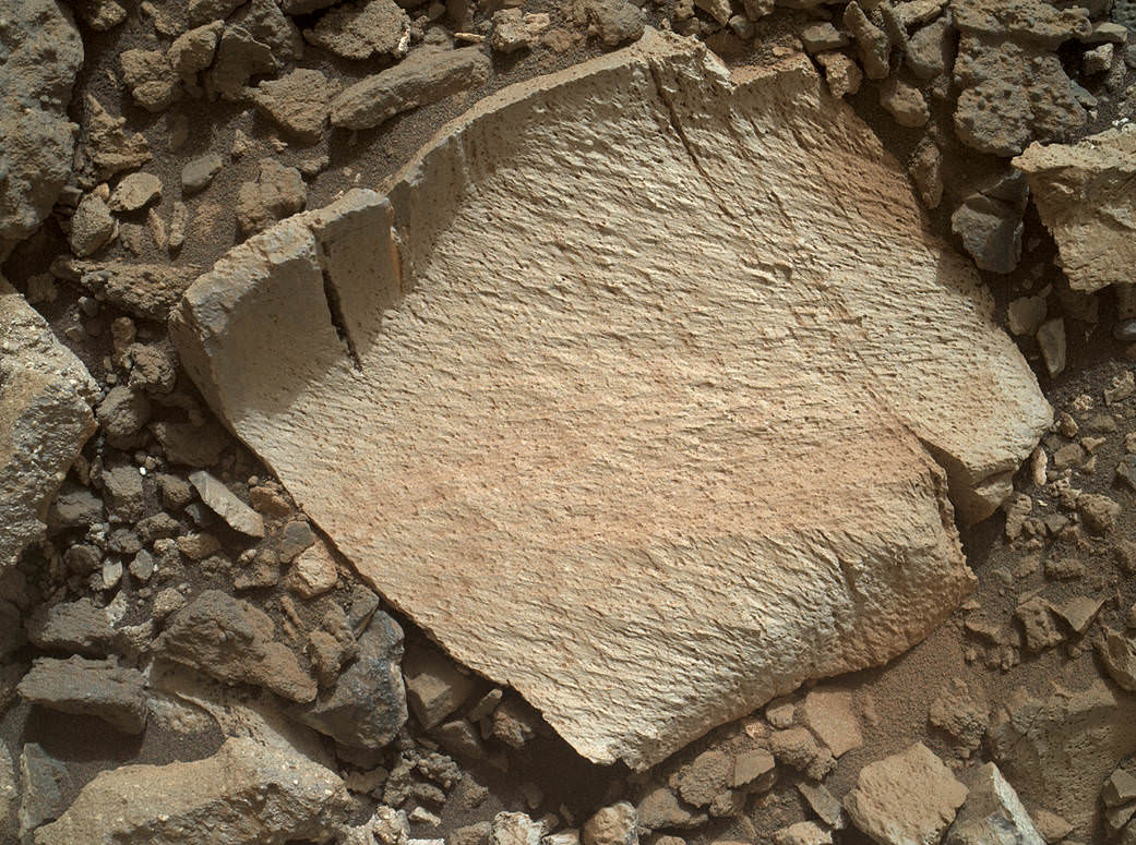
A rock fragment dubbed "Lamoose" is shown in this picture taken by the Mars Hand Lens Imager (MAHLI) on NASA's Curiosity rover. Like other nearby rocks in a portion of the "Marias Pass" area of Mt. Sharp, Mars, it has unusually high concentrations of silica. The high silica was first detected in the area by the Chemistry & Camera (ChemCam) laser spectrometer. This rock was targeted for follow-up study by the MAHLI and the arm-mounted Alpha Particle X-ray Spectrometer (APXS).  Credits: NASA/JPL-Caltech/MSSS
A rock fragment dubbed “Lamoose” is shown in this picture taken by the Mars Hand Lens Imager (MAHLI) on NASA’s Curiosity rover. Like other nearby rocks in a portion of the “Marias Pass” area of Mt. Sharp, Mars, it has unusually high concentrations of silica. The high silica was first detected in the area by the Chemistry & Camera (ChemCam) laser spectrometer. This rock was targeted for follow-up study by the MAHLI and the arm-mounted Alpha Particle X-ray Spectrometer (APXS). Credits: NASA/JPL-Caltech/MSSS

Before arriving by the “Lion” outcrop last week, Curiosity was investigating another outcrop area nearby, the high-silica target dubbed “Elk” with the ChemCam instrument, while scouting around the “Marias Pass” area in search of tasty science targets for in-depth analysis.

Sometimes the data subsequently returned and analyzed is so extraordinary, that the team decides on a return trip to a spot previously departed. Such was the case with “Elk” and the rover was commanded to do a U-turn to acquire more precious data.

“One never knows what to expect on Mars, but the Elk target was interesting enough to go back and investigate,” said Roger Wiens, the principal investigator of the ChemCam instrument from the Los Alamos National Laboratory in New Mexico.

Soon, ChemCam will have fired on its 1,000th target. Overall the laser blaster has been fired more than 260,000 times since Curiosity landed inside the nearly 100 mile wide Gale Crater on Mars on Aug. 6, 2012, alongside Mount Sharp.

“ChemCam acts like eyes and ears of the rover for nearby objects,” said Wiens.

“Marias Pass” is a geological context zone where two rock types overlap – pale mudstone meets darker sandstone.

The rover spotted a very curious outcrop named “Missoula.”

“We found an outcrop named Missoula where the two rock types came together, but it was quite small and close to the ground. We used the robotic arm to capture a dog’s-eye view with the MAHLI camera, getting our nose right in there,” said Ashwin Vasavada, the mission’s project scientist at NASA’s Jet Propulsion Laboratory in Pasadena, California.

White mineral veins, possibly comprised of calcium sulfate, filled the fractures by depositing the mineral from running groundwater.

“Such clues help scientists understand the possible timing of geological events,” says the team.

Read more about Curiosity in an Italian language version of this story at Alive Universe Images – here.

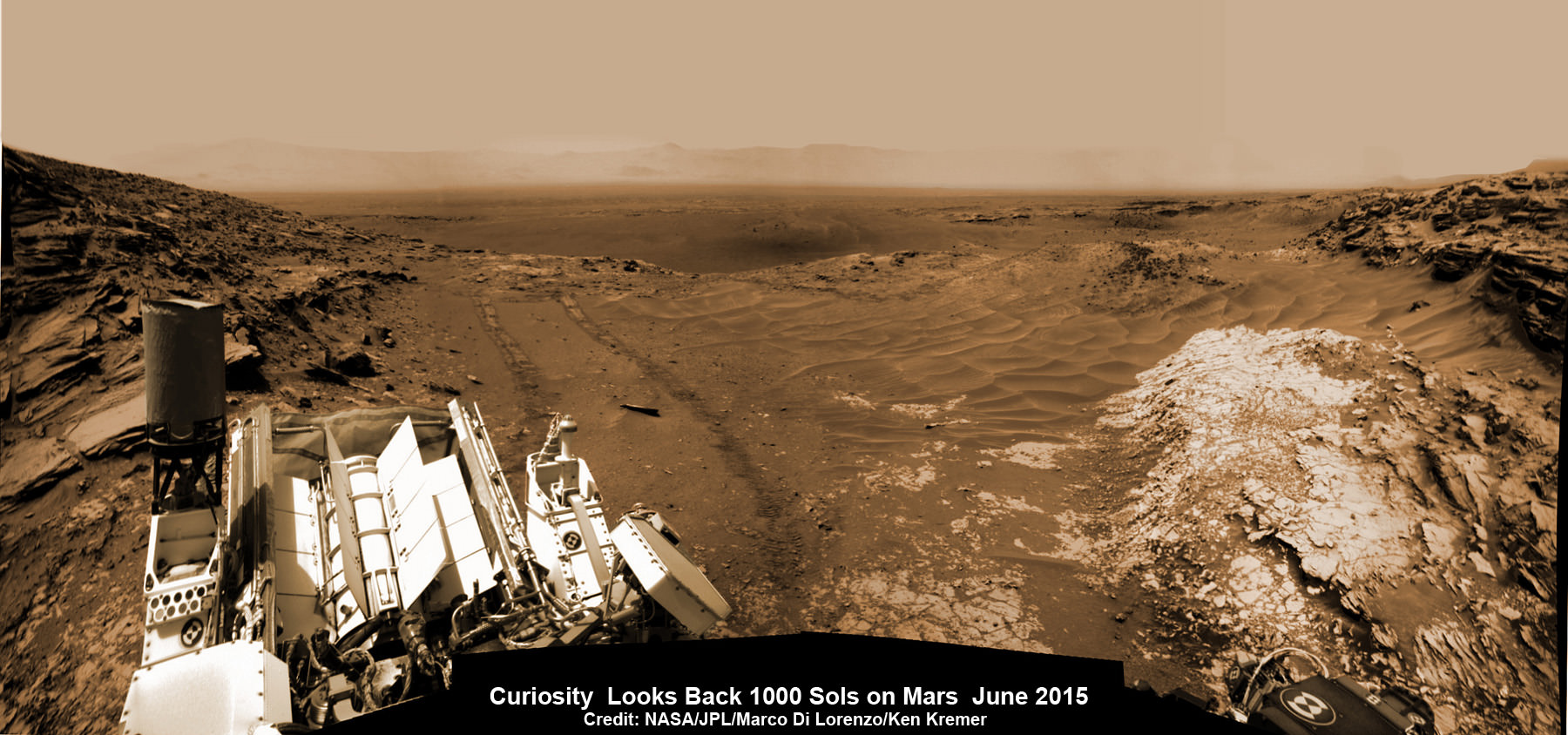
NASA’s Martian Curiosity rover looks backs to 1000 Sols of science and exploration on the surface of the Red Planet.  Robot wheel tracks lead back through valley dunes.  Gale Crater rim seen in the distant hazy background.  Sol 997 (May 28, 2015) navcam camera raw images stitched and colorized. Credit:  NASA/JPL-Caltech/ Marco Di Lorenzo/Ken Kremer/kenkremer.com
NASA’s Martian Curiosity rover looks backs to 1000 Sols of science and exploration on the surface of the Red Planet. Robot wheel tracks lead back through valley dunes. Gale Crater rim seen in the distant hazy background. Sol 997 (May 28, 2015) navcam camera raw images stitched and colorized. Credit: NASA/JPL-Caltech/ Marco Di Lorenzo/Ken Kremer/kenkremer.com
Featured on APOD on June 13, 2015

As of today, Sol 1060, July 31, 2015, she has taken over 255,000 amazing images.

Curiosity recently celebrated 1000 Sols of exploration on Mars on May 31, 2015 – detailed here with our Sol 1000 mosaic also featured at Astronomy Picture of the Day on June 13, 2015.

Stay tuned here for Ken’s continuing Earth and planetary science and human spaceflight news.

Ken Kremer

Red Mars, Gray Mars: "Mini-start hole" drill maneuver was successful.  Image of mini start drill hole taken by Mars Hand Lens Imager (MAHLI) aboard NASA's Mars rover Curiosity on July 30, 2015, Sol 1059. Credit: NASA/JPL-Caltech/MSSS
Red Mars, Gray Mars: “Mini-start hole” drill maneuver was successful. Image of mini start drill hole taken by Mars Hand Lens Imager (MAHLI) aboard NASA’s Mars rover Curiosity on July 30, 2015, Sol 1059. Credit: NASA/JPL-Caltech/MSSS
Curiosity conducts test drill at “Buckskin” rock target at bright toned “Lion” outcrop on the lower region of Mount Sharp on Mars, seen at right.   Gale crater rim seen in the distant background at left, in this composite mosaic of navcam raw images taken to Sol 1059, July 30, 2015.  Navcam camera raw images stitched. Credit:  NASA/JPL-Caltech/Ken Kremer/kenkremer.com/Marco Di Lorenzo
Curiosity extends robotic arm and conducts test drill at “Buckskin” rock target at bright toned “Lion” outcrop on the lower region of Mount Sharp on Mars, seen at right. Gale crater rim seen in the distant background at left, in this composite mosaic of navcam raw images taken to Sol 1059, July 30, 2015. Navcam camera raw images stitched. Credit: NASA/JPL-Caltech/Ken Kremer/kenkremer.com/Marco Di Lorenzo

What Are These Strange Scarlet Streaks Spotted on Tethys?

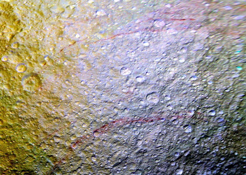
Enhanced-color image from Cassini showing red streaks on Tethys (NASA/JPL-Caltech/Space Science Institute)

Resembling what the skin on my arms looks like after giving my cat a bath, the surface of Saturn’s moon Tethys is seen above in an extended-color composite from NASA’s Cassini spacecraft showing strange long red streaks. They stretch for long distances across the moon’s surface following the rugged terrain, continuing unbroken over hills and down into craters… and their cause isn’t yet known.

According to a NASA news release, “The origin of the features and their reddish color is currently a mystery to Cassini scientists. Possibilities being studied include ideas that the reddish material is exposed ice with chemical impurities, or the result of outgassing from inside Tethys. The streaks could also be associated with features like fractures that are below the resolution of the available images.”

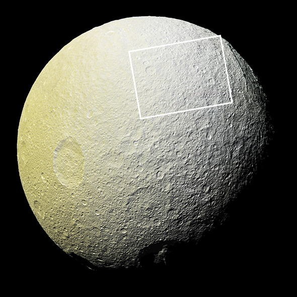
The images were taken by Cassini during a flyby of the 660-mile-wide (1,062 km) Tethys on April 11, 2015 at a resolution of about 2,300 feet (700 meters) per pixel. They were acquired in visible green, infrared,  and ultraviolet light wavelengths and so the composite image reveals colors our eyes can’t directly perceive. The combination of this and the solar illumination needed to image this particular area as the spacecraft passed by are why these features haven’t been seen so well until now.

“The red arcs really popped out when we saw the new images,” said Cassini participating scientist Paul Schenk of the Lunar and Planetary Institute in Houston. “It’s surprising how extensive these features are.”

Extended color mosaic of Tethys from Cassini images acquired on April 11, 2015. The region where the streaks are is outlined. Click for original hi-res version. (NASA/JPL-Caltech/SSI)

While the nature of Tethys’ streaks isn’t understood, the observations do indicate a relatively young age compared to the surrounding surface.

“The red arcs must be geologically young because they cut across older features like impact craters, but we don’t know their age in years.” said Paul Helfenstein, a Cassini imaging scientist at Cornell University in Ithaca. “If the stain is only a thin, colored veneer on the icy soil, exposure to the space environment at Tethys’ surface might erase them on relatively short time scales.”

Reprocessed Galileo image of Europa's frozen surface by Ted Stryk (NASA/JPL/Ted Stryk)
Reprocessed Galileo image of Europa’s streaked surface by Ted Stryk (NASA/JPL/Ted Stryk)

Could these arcs be signs of an underground ocean or reservoir of briny liquid, like Enceladus’ tiger stripes (aka sulcae) or the streaks that crisscross Europa’s ice? Or are they the results of infalling material from one of Saturn’s other moons? More observations with Cassini, now in its eleventh year in orbit at Saturn, are being planned to “study the streaks.”

“We are planning an even closer look at one of the Tethys red arcs in November to see if we can tease out the source and composition of these unusual markings,” said Linda Spilker, Cassini project scientist at JPL.

Source: NASA JPL

Faces of the Solar System

Move over, Pluto... Disney already has dibs on Mercury as seen in this MESSENGER photo. Image credit: NASA/JHAPL/Carnegie institution of Washington

“Look, it has a tiny face on it!”

This sentiment was echoed ‘round the web recently, as an image of Pluto’s tiny moon Nix was released by the NASA New Horizons team. Sure, we’ve all been there. Lay back in a field on a lazy July summer’s day, and soon, you’ll see faces of all sorts in the puffy stratocumulus clouds holding the promise of afternoon showers.

Pluto's moon Nix as imaged by New Horizons from 590,000 kilometers distant. Image credit: NASA/JHUAPL/SWRI
Pluto’s moon Nix as imaged by New Horizons from 590,000 kilometers distant. Image credit: NASA/JHUAPL/SWRI

This predilection is so hard-wired into our brains, that often our facial recognition software sees faces where there are none. Certainly, seeing faces is a worthy survival strategy; not only is this aspect of cognition handy in recognizing the friendlies of our own tribe, but it’s also useful in the reading of facial expressions by giving us cues of the myriad ‘tells’ in the social poker game of life.

And yes, there’s a term for the illusion of seeing faces in the visual static: pareidolia. We deal lots with pareidolia in astronomy and skeptical circles. As NASA images of brave new worlds are released, an army of basement bloggers are pouring over them, seeing miniature bigfoots, flowers, and yes, lots of humanoid figures and faces. Two craters and the gash of a trench for a mouth will do.

Now that new images of Pluto and its entourage of moons are pouring in, neural circuits ‘cross the web are misfiring, seeing faces, half-buried alien skeletons and artifacts strewn across Pluto and Charon. Of course, most of these claims are simply hilarious and easily dismissed… no one, for example, thinks the Earth’s Moon is an artificial construct, though its distorted nearside visage has been gazing upon the drama of humanity for millions of years.

Do you see the 'Man in the Moon?' Image credit: Dave Dickinson
Do you see the ‘Man in the Moon?’ Image credit: Dave Dickinson

The psychology of seeing faces is such that a whole region of the occipital lobe of the brain known as the fusiform face area is dedicated to facial recognition. We each have a unique set of neurons that fire in patterns to recognize the faces of Donald Trump and Hillary Clinton, and other celebs (thanks, internet).

Damage this area at the base of the brain or mess with its circuitry, and a condition known as prosopagnosia, or face blindness can occur. Author Oliver Sacks and actor Brad Pitt are just a few famous personalities who suffer from this affliction.

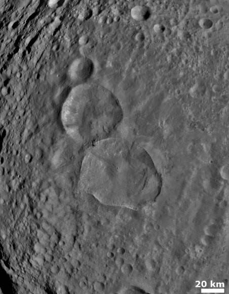
The 'Snowman of Vesta,' as imaged by NASA's Dawn spacecraft. Image credit: NASA/JPL-Caltech/UCLA/MPS/DLR/IDA
The ‘Snowman of Vesta,’ as imaged by NASA’s Dawn spacecraft. Image credit: NASA/JPL-Caltech/UCLA/MPS/DLR/IDA
Conversely, ‘super-recognizers’ at the other end of the spectrum have a keen sense for facial identification that verges on a super-power. True story: my wife has just such a gift, and can immediately spot second-string actors and actresses in modern movies from flicks and television shows decades old.

It would be interesting to know if there’s a correlation between face blindness, super-recognition and seeing faces in the shadows and contrast on distant worlds… to our knowledge, no such study has been conducted. Do super-recognizers see faces in the shadowy ridges and craters of the solar system more or less than everyone else?

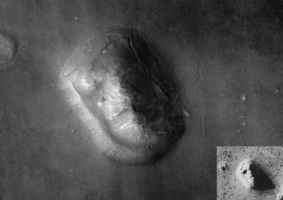
A well-known example was the infamous ‘Face on Mars.’ Imaged by the Viking 1 orbiter in 1976, this half in shadow image looked like a human face peering back up at us from the surface of the Red Planet from the Cydonia region.
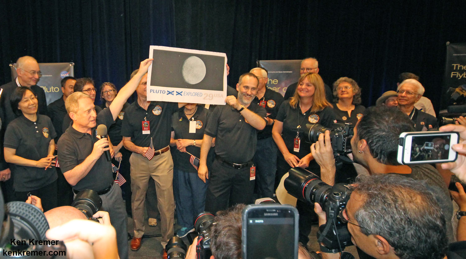
Image credit: The 'Face on Mars': HiRISE vs Viking 1 (inset): Image credit: NASA/JPL
Image credit: The ‘Face on Mars’: HiRISE vs Viking 1 (inset): Image credit: NASA/JPL

But when is a face not a face?

Now, it’s not an entirely far-fetched idea that an alien entity visiting the solar system would place something (think the monolith on the Moon from Arthur C. Clarke’s 2001: A Space Odyssey) for us to find. The idea is simple: place such an artifact so that it not only sticks out like a sore thumb, but also so it isn’t noticed until we become a space-faring society. Such a serious claim would, however, to paraphrase Carl Sagan, demand serious and rigorous evidence.

But instead of ‘Big NASA’ moving to cover up the ‘face,’ they did indeed re-image the region with both the Mars Reconnaissance Orbiter and Mars Global Surveyor at a much higher resolution. Though the 1.5 kilometer feature is still intriguing from a geological perspective… it’s now highly un-facelike in appearance.

A 'face' or... more fun with 'scifi spacecraft pareidolia. Image credit: NASA/JPL/Paramount Pictures
A ‘face’ or… more fun with ‘scifi spacecraft pareidolia.’ Image credit: NASA/JPL/Paramount Pictures

Of course, it won’t stop the deniers from claiming it was all a big cover-up… but if that were the case, why release such images and make them freely available online? We’ve worked in the military before, and can attest that NASA is actually the most transparent of government agencies.

We also know the click bait claims of all sorts of alleged sightings will continue to crop up across the web, with cries of ‘Wake up, Sheeople!’ (usually in all caps) as a brave band of science-writing volunteers continue to smack down astro-pareidolia on a pro bono basis in battle of darkness and light which will probably never end.

What examples of astro-pareidolia have you come across in your exploits?

See Pluto’s Icy Flow Plains and Mountains Revealed in Highest Resolution Flyover Mosaic and Movie

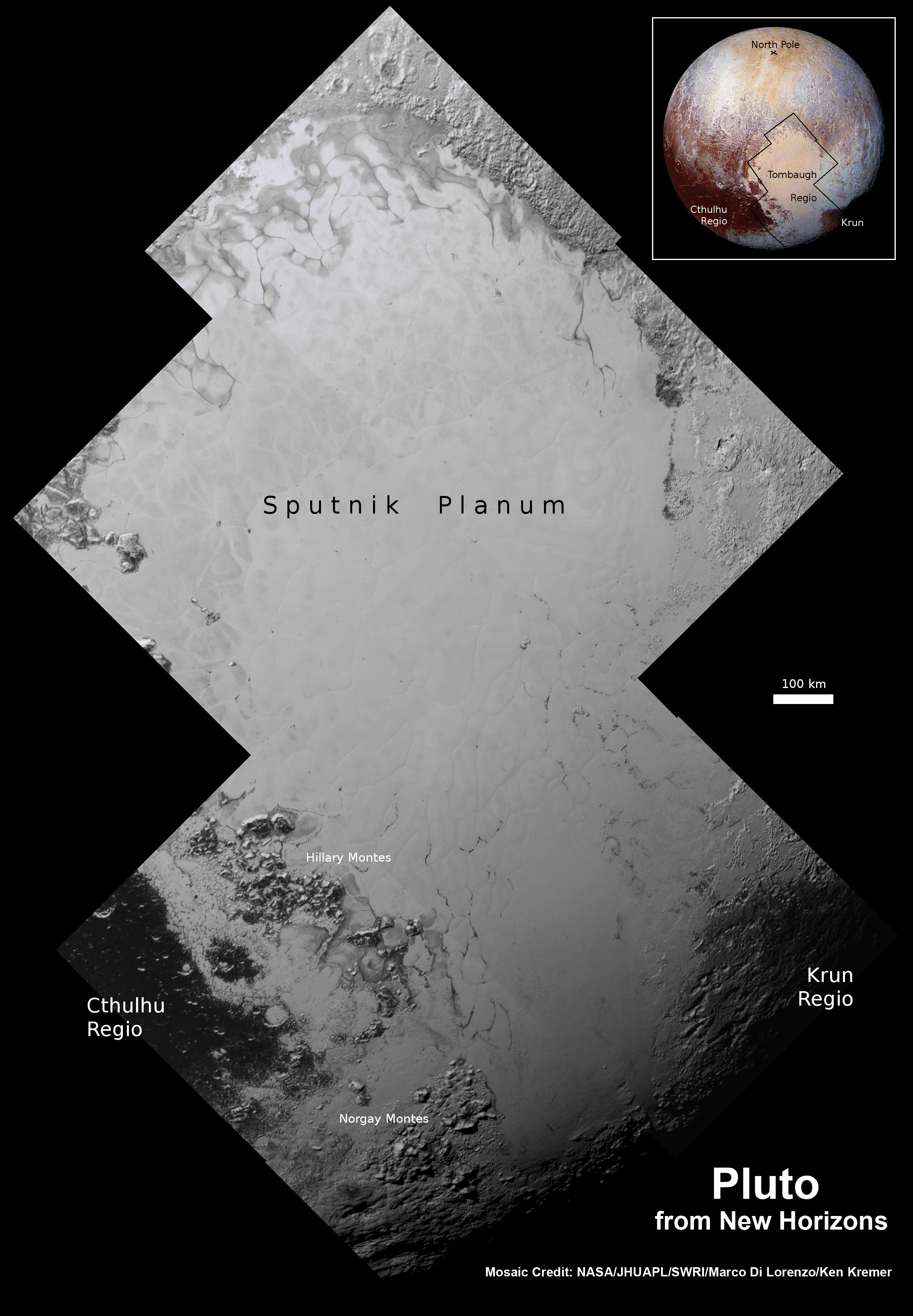
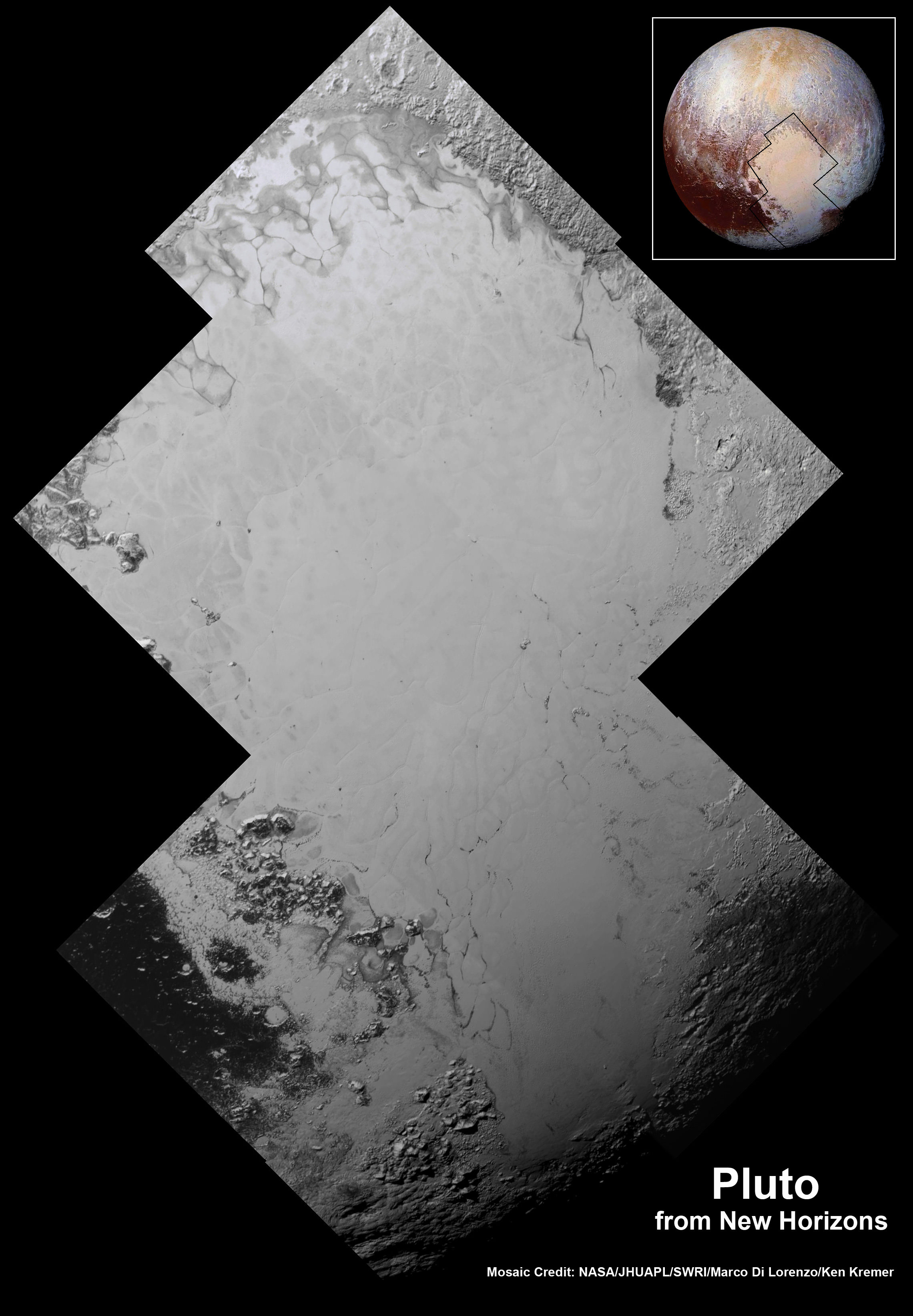
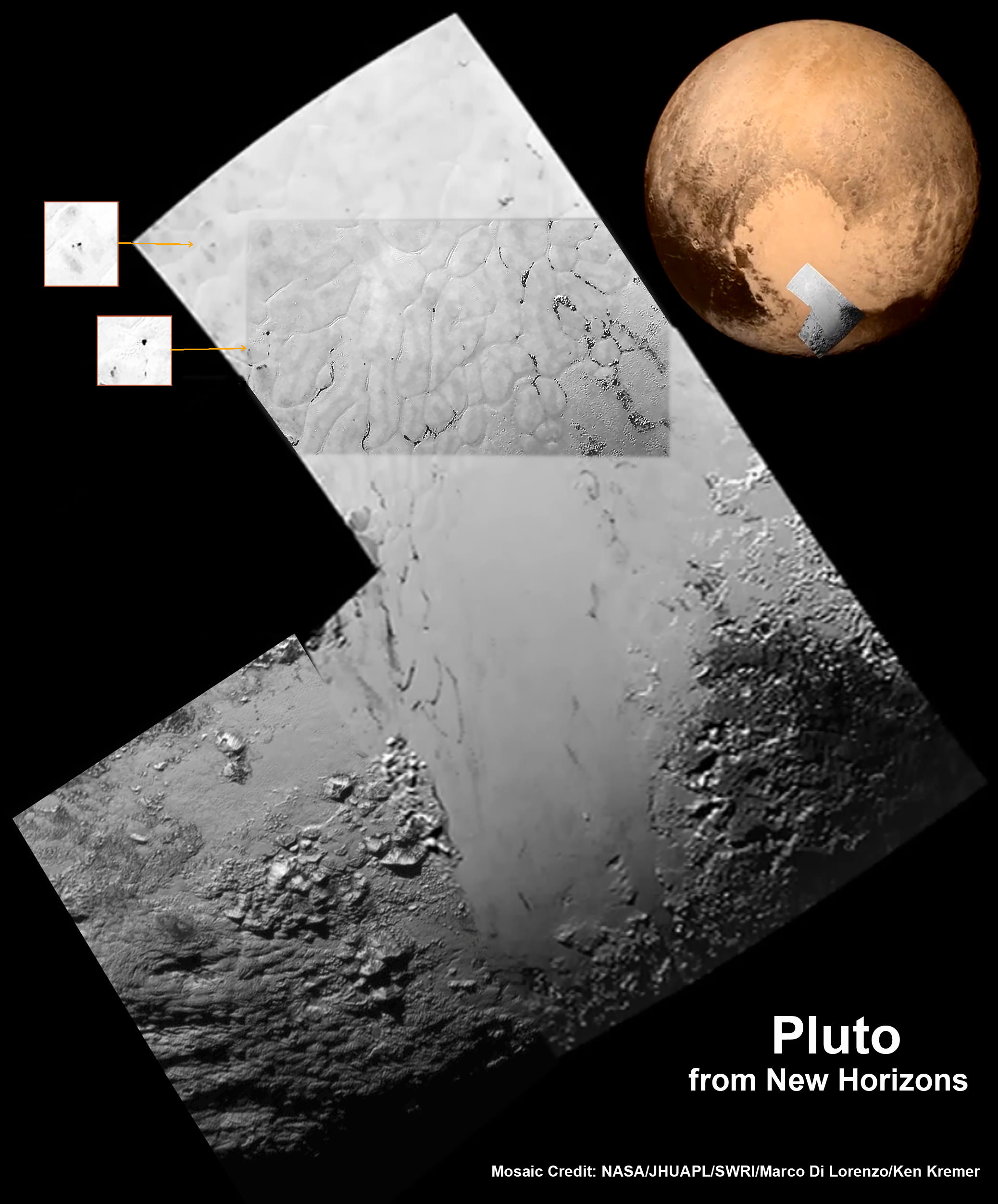
Highest resolution mosaic of ‘Tombaugh Regio’ shows the heart-shaped region on Pluto focusing on ice flows and plains of ‘Sputnik Planum’ at top and icy mountain ranges of ‘Hillary Montes’ and ‘Norgay Montes’ below. This new mosaic combines the seven highest resolution images captured by NASA’s New Horizons LORRI imager during history making closest approach flyby on July 14, 2015. Inset at right shows global view of Pluto with location of mosaic and huge heart-shaped region in context. Annotated with place names. Credit: NASA/JHUAPL/SWRI/ Marco Di Lorenzo/Ken Kremer/kenkremer.com

Highest resolution mosaic of ‘Tombaugh Regio’ shows the heart-shaped region on Pluto focusing on ice flows and plains of ‘Sputnik Planum’ at top and icy mountain ranges of ‘Hillary Montes’ and ‘Norgay Montes’ below. This new mosaic combines the seven highest resolution images captured by NASA’s New Horizons LORRI imager during history making closest approach flyby on July 14, 2015. Inset at right shows global view of Pluto with location of mosaic and huge heart-shaped region in context. Annotated with place names. Credit: NASA/JHUAPL/SWRI/ Marco Di Lorenzo/Ken Kremer/kenkremer.com
Unannotated version below[/caption]

Until barely two weeks ago, Pluto tantalized humanity for eight decades with mysteries we could only imagine – seen as just a point of light or fuzzy blob in the world’s most powerful telescopes.

Now the last explored planetary system in our solar system is being revealed for the first time in history to human eyes, piece by piece, in the form of the highest resolution flyover mosaics and movies of the alien surface ever available, now and for decades to come.

And it’s all thanks to the brilliant efforts of the scientists and engineers leading NASA’s New Horizons mission – which culminated in the first ever close encounter with Pluto and its five moons by a spacecraft from Earth on July 14, 2015.

With the resoundingly successful close flyby completed and the piano shaped New Horizons probe now looking in the rear view mirror, the scientific booty is raining down on receivers back on Earth. However it will take about 16 months to send all the flyby science data back to Earth due to limited bandwidth.

The first series of seven breathtaking high resolution surface images focusing on Pluto’s bright heart-shaped region, informally named ‘Tombaugh Regio’, has been stitched together into our new and wider view mosaic, shown above and below, by the image processing team of Marco Di Lorenzo and Ken Kremer.

Furthermore the New Horizons team has created a spectacular simulated flyover movie centered in the heart of Pluto’s huge ‘Heart’ at ‘Tombaugh Regio’, showing the stunning views including the incredibly recent ice flows and plains of ‘Sputnik Planum’ and monumental icy mountain ranges of ‘Norgay Montes’ and newly discovered ‘Hillary Montes.’

The mosaic and movie are compiled from the seven highest resolution images captured by NASA’s New Horizons LORRI imager during the history making closest approach flyby.

The LORRI images were taken from a distance of 48,000 miles (77,000 kilometers) from the surface of the planet about 1.5 hours prior to the closest approach at 7:49 a.m. EDT on July 14. The images easily resolve structures smaller than a mile across.

New Horizon’s unveiled Pluto as a surprising vibrant and geologically active “icy world of wonders” as it barreled past the Pluto-Charon double planet system on July 14 at over 31,000 mph (49,600 kph) and collected unprecedented high resolution imagery and spectral measurements of the utterly alien worlds.

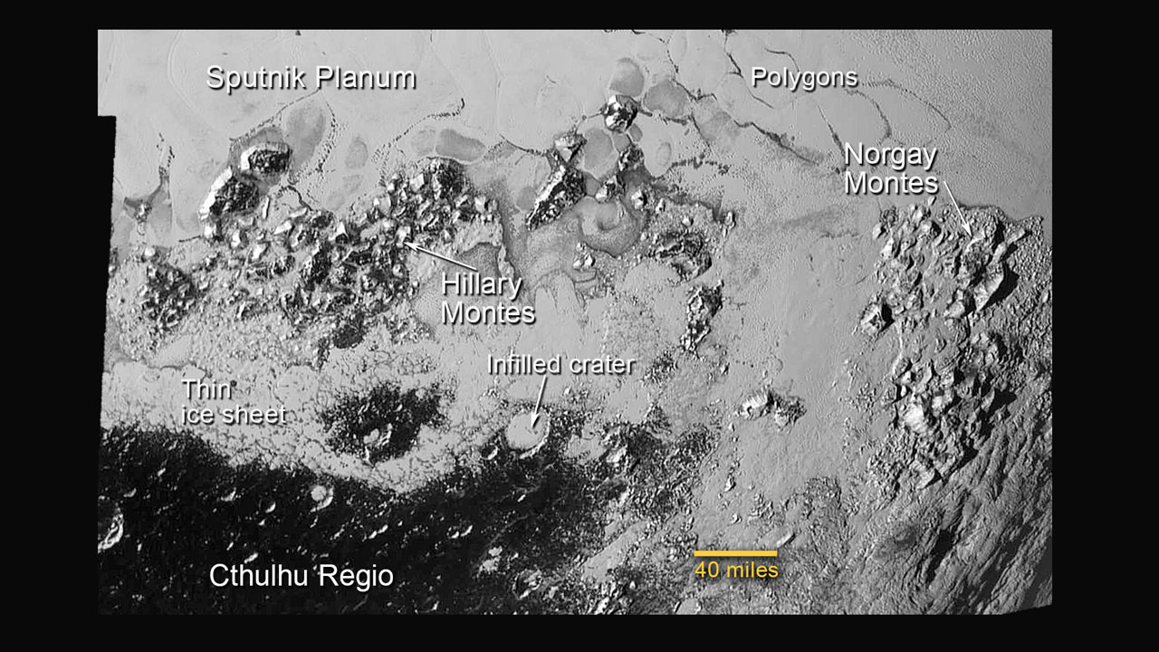
This annotated image of the southern region of Sputnik Planum illustrates its complexity, including the polygonal shapes of Pluto’s icy plains, its two mountain ranges, and a region where it appears that ancient, heavily-cratered terrain has been invaded by much newer icy deposits. The large crater highlighted in the image is about 30 miles (50 kilometers) wide, approximately the size of the greater Washington, DC area.  Credits: NASA/JHUAPL/SwRI
This annotated image of the southern region of Sputnik Planum illustrates its complexity, including the polygonal shapes of Pluto’s icy plains, its two mountain ranges, and a region where it appears that ancient, heavily-cratered terrain has been invaded by much newer icy deposits. The large crater highlighted in the image is about 30 miles (50 kilometers) wide, approximately the size of the greater Washington, DC area. Credits: NASA/JHUAPL/SwRI

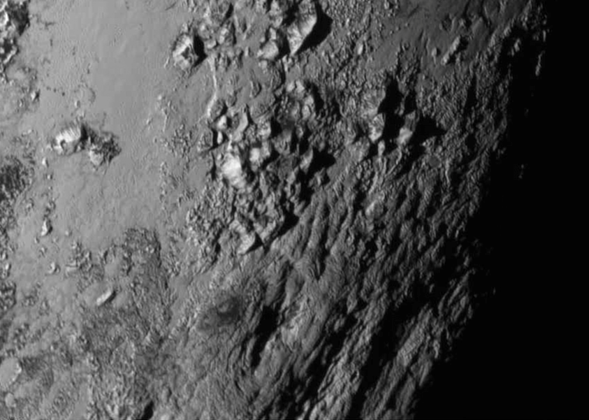
The newly-discovered mountain range has been informally named Hillary Montes (Hillary Mountains) for Sir Edmund Hillary, who first summited Mount Everest with Tenzing Norgay in 1953. They rise about one mile (1.6 kilometers) above the surrounding plains, similar to the height of the Appalachian Mountains in the United States.

They are located nearby and somewhat north of another mountain range discovered first and named Norgay Montes (Norgay Mountains).

“For many years, we referred to Pluto as the Everest of planetary exploration,” said New Horizons Principal Investigator Alan Stern of the Southwest Research Institute, Boulder, Colorado.

“It’s fitting that the two climbers who first summited Earth’s highest mountain, Edmund Hillary and Tenzing Norgay, now have their names on this new Everest.”

Watch this flyover above Pluto’s icy plains at Sputnik Planum and Hillary Montes:

Video caption: This simulated flyover of two regions on Pluto, northwestern Sputnik Planum (Sputnik Plain) and Hillary Montes (Hillary Mountains), was created from New Horizons close-approach images. Sputnik Planum has been informally named for Earth’s first artificial satellite, launched in 1957. Hillary Montes have been informally named for Sir Edmund Hillary, one of the first two humans to reach the summit of Mount Everest in 1953. The images were acquired by the Long Range Reconnaissance Imager (LORRI) on July 14 from a distance of 48,000 miles (77,000 kilometers). Features as small as one-half mile (1 kilometer) across are visible. Credit: NASA/JHUAPL/SwRI

The LORRI images show “extensive evidence of exotic ices flowing across Pluto’s surface and revealing signs of recent geologic activity, something scientists hoped to find but didn’t expect.”

Sputnik Planum is a Texas-sized plain, which lies on the western, left half of Pluto’s bilobed and bright heart-shaped feature, known as Tombaugh Regio.

The new imagery and spectral evidence from the Ralph instrument appears to show the flow of nitrogen ices in geologically recent times across a vast region. They appear to flow similar to glaciers on Earth. There are also carbon monoxide and methane ices mixed in with the water ices.

“At Pluto’s temperatures of minus-390 degrees Fahrenheit, these ices can flow like a glacier,” said Bill McKinnon, deputy leader of the New Horizons Geology, Geophysics and Imaging team at Washington University in St. Louis.

“In the southernmost region of the heart, adjacent to the dark equatorial region, it appears that ancient, heavily-cratered terrain has been invaded by much newer icy deposits.”

“We see the flow of viscous ice that looks like glacial flow.”

Highest resolution mosaic of ‘Tombaugh Regio’ shows the heart-shaped region on Pluto focusing on ice flows and plains of ‘Sputnik Planum’ at top and icy mountain ranges of ‘Hillary Montes’ and ‘Norgay Montes’ below.  This new mosaic combines the seven highest resolution images captured by NASA’s New Horizons LORRI imager during history making closest approach flyby on July 14, 2015.  Inset at right shows global view of Pluto with location of mosaic and huge heart-shaped region in context.  Credit: NASA/JHUAPL/SWRI/Marco Di Lorenzo/Ken Kremer/kenkremer.com
Highest resolution mosaic of ‘Tombaugh Regio’ shows the heart-shaped region on Pluto focusing on ice flows and plains of ‘Sputnik Planum’ at top and icy mountain ranges of ‘Hillary Montes’ and ‘Norgay Montes’ below. This new mosaic combines the seven highest resolution images captured by NASA’s New Horizons LORRI imager during history making closest approach flyby on July 14, 2015. Inset at right shows global view of Pluto with location of mosaic and huge heart-shaped region in context. Credit: NASA/JHUAPL/SWRI/Marco Di Lorenzo/Ken Kremer/kenkremer.com

As of today, July 26, New Horizons is 12 days past the Pluto flyby and already over 15 million kilometers beyond Pluto and continuing its journey into the Kuiper Belt, the third realm of worlds in our solar system.

New Horizons discovered that Pluto is the largest known body beyond Neptune – and thus reigns as the “King of the Kuiper Belt!”

The science team plans to target New Horizons to fly by another smaller Kuiper Belt Object (KBO) as soon as 2018.

Watch for Ken’s continuing coverage of the Pluto flyby. He was onsite reporting live on the flyby and media briefings for Universe Today from the Johns Hopkins University Applied Physics Laboratory (APL), in Laurel, Md.

Stay tuned here for Ken’s continuing Earth and planetary science and human spaceflight news.

Ken Kremer

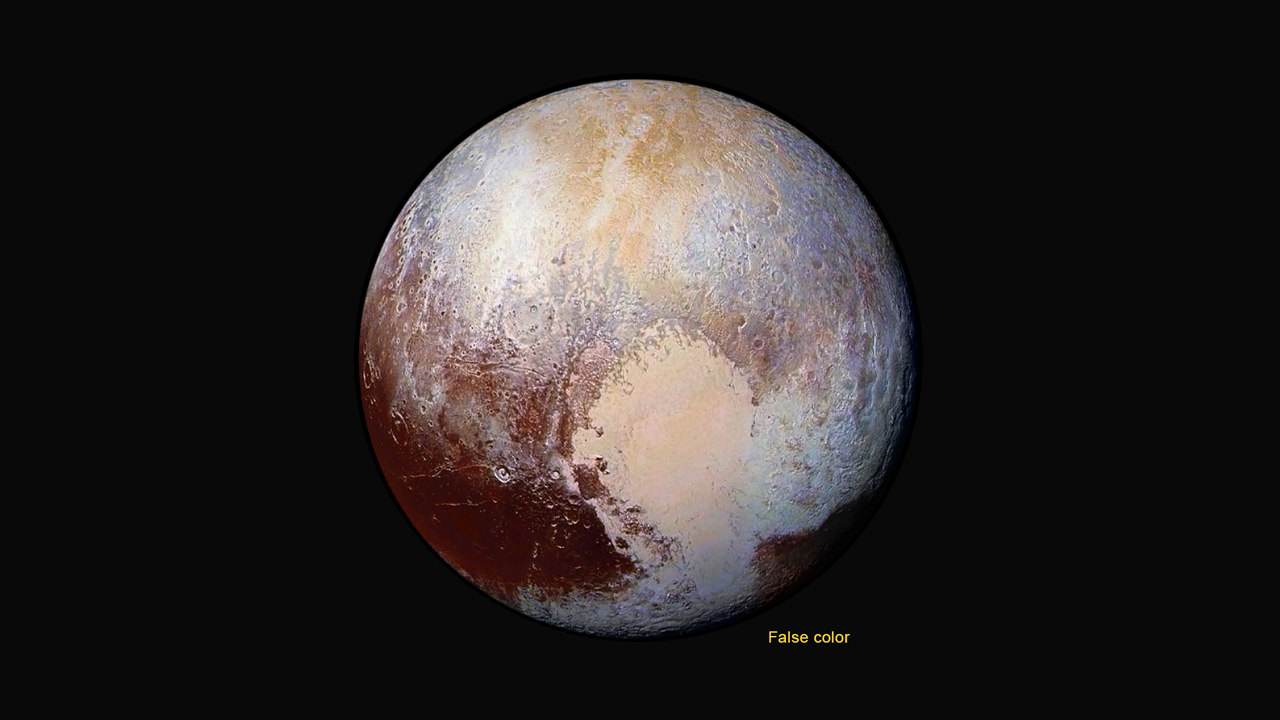
Four images from New Horizons’ Long Range Reconnaissance Imager (LORRI) were combined with color data from the Ralph instrument to create this enhanced color global view of Pluto. (The lower right edge of Pluto in this view currently lacks high-resolution color coverage.) The images, taken when the spacecraft was 280,000 miles (450,000 kilometers) away, show features as small as 1.4 miles (2.2 kilometers), twice the resolution of the single-image view taken on July 13.  Credits: NASA/JHUAPL/SwRI
Four images from New Horizons’ Long Range Reconnaissance Imager (LORRI) were combined with color data from the Ralph instrument to create this enhanced color global view of Pluto. (The lower right edge of Pluto in this view currently lacks high-resolution color coverage.) The images, taken when the spacecraft was 280,000 miles (450,000 kilometers) away, show features as small as 1.4 miles (2.2 kilometers), twice the resolution of the single-image view taken on July 13. Credits: NASA/JHUAPL/SwRI

Flowing Ice, Exotic Mountains and Backlit Haze Highlight Pluto as Never Seen Before

Backlit by the sun, Pluto’s atmosphere rings its silhouette like a luminous halo in this image taken by NASA’s New Horizons spacecraft around midnight EDT on July 15. This global portrait of the atmosphere was captured when the spacecraft was about 1.25 million miles (2 million kilometers) from Pluto and shows structures as small as 12 miles across. The image, delivered to Earth on July 23, is displayed with north at the top of the frame. Credits: NASA/JHUAPL/SwRI

Spectacular imagery of huge regions of flowing ice, monumental mountain ranges and a breathtakingly backlit atmospheric haze showing Pluto as we’ve never seen it before, were among the newest discoveries announced today, July 24, by scientists leading NASA’s New Horizons mission which sped past the planet for humanity’s first ever up-close encounter only last week.

New Horizon’s revealed Pluto be an unexpectedly vibrant “icy world of wonders” as it barreled by the Pluto-Charon double planet system last Tuesday, July 14, at over 31,000 mph (49,600 kph).

The scientists publicly released a series of stunning new images and science discoveries at Pluto that exceeded all pre-flyby expectations.

“The images of Pluto are spectacular,” said John Grunsfeld, NASA’s associate administrator for the Science Mission Directorate, at today’s media briefing.

“We knew that a mission to Pluto would bring some surprises, and now — 10 days after closest approach — we can say that our expectation has been more than surpassed. With flowing ices, exotic surface chemistry, mountain ranges, and vast haze, Pluto is showing a diversity of planetary geology that is truly thrilling.”

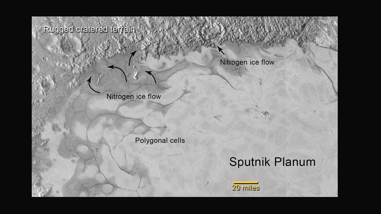
New Horizons discovers flowing ices in Pluto’s heart-shaped feature. In the northern region of Pluto’s Sputnik Planum (Sputnik Plain), swirl-shaped patterns of light and dark suggest that a surface layer of exotic ices has flowed around obstacles and into depressions, much like glaciers on Earth.  Credits: NASA/JHUAPL/SwRI
New Horizons discovers flowing ices in Pluto’s heart-shaped feature. In the northern region of Pluto’s Sputnik Planum (Sputnik Plain), swirl-shaped patterns of light and dark suggest that a surface layer of exotic ices has flowed around obstacles and into depressions, much like glaciers on Earth. Credits: NASA/JHUAPL/SwRI

Over 50 gigabits of data were collected during the encounter and flyby periods of the highest scientific activity in the most critical hours before and after the spacecrafts closest approach to Pluto, its largest moon Charon and its quartet of smaller moons.

Data from the flyby is now raining back to Earth, but slowly due to limited bandwidth of an average “downlink” of only about 2 kilobits per second via its two transmitters.

“So far we’ve seen only about 5% of the encounter data,” said Jim Green, director of Planetary Science at NASA Headquarters in Washington.

At that pace it will take about 16 months to send all the flyby science data back to Earth.

Among the top highlights is the first view ever taken from the back side of Pluto, a backlit view that humans have never seen before.

It shows a global portrait of the planets extended atmosphere and was captured when NASA’s New Horizons spacecraft was about 1.25 million miles (2 million kilometers) from Pluto. It shows structures as small as 12 miles across.

“The silhouette of Pluto taken after the flyby and show a remarkable haze of light representing the hazy worlds extended atmosphere,” Alan Stern, principal investigator for New Horizons at the Southwest Research Institute (SwRI) in Boulder, Colorado, said at the media briefing.

“The image is the equivalent of the Apollo astronauts Earth-rise images.”

“It’s the first image of Pluto’s atmosphere!” said Michael Summers, New Horizons co-investigator at George Mason University in Fairfax, Virginia, at the briefing.

“We’ve known about the atmosphere for over 25 years,” and now we can see it. There are haze layers and it shows structure and weather. There are two distinct layers of haze. One at about 30 miles (50 kilometers) and another at about 50 miles (80 kilometers) above the surface.”

“The haze extend out about 100 miles! Which is five times more than expected.”

This annotated image of the southern region of Sputnik Planum illustrates its complexity, including the polygonal shapes of Pluto’s icy plains, its two mountain ranges, and a region where it appears that ancient, heavily-cratered terrain has been invaded by much newer icy deposits. The large crater highlighted in the image is about 30 miles (50 kilometers) wide, approximately the size of the greater Washington, DC area.  Credits: NASA/JHUAPL/SwRI
This annotated image of the southern region of Sputnik Planum illustrates its complexity, including the polygonal shapes of Pluto’s icy plains, its two mountain ranges, and a region where it appears that ancient, heavily-cratered terrain has been invaded by much newer icy deposits. The large crater highlighted in the image is about 30 miles (50 kilometers) wide, approximately the size of the greater Washington, DC area. Credits: NASA/JHUAPL/SwRI

The image was taken by New Horizons’ high resolution Long Range Reconnaissance Imager (LORRI) while looking back at Pluto, barely seven hours after closest approach at 7:49 a.m. EDT on July 14, and gives significant clues about the atmosphere’s dynamics and interaction with the surface. It captures sunlight streaming through the atmosphere.

“The hazes detected in this image are a key element in creating the complex hydrocarbon compounds that give Pluto’s surface its reddish hue.”

Methane (CH4) in the upper atmosphere break down by interaction of UV radiation and forms ethylene and acetylene which leads to more complex hydrocarbons known as tholins – which the team says is responsible for Pluto’s remarkable reddish hue.

The team also released new LORRI images showing “extensive evidence of exotic ices flowing across Pluto’s surface and revealing signs of recent geologic activity, something scientists hoped to find but didn’t expect.”

The images focuses on Sputnik Planum, a Texas-sized plain, which lies on the western, left half of Pluto’s bilobed and bright heart-shaped feature, known as Tombaugh Regio.

Pluto and Charon are shown in a composite of natural-color images from New Horizons. Images from the Long Range Reconnaissance Imager (LORRI) were combined with color data from the Ralph instrument to produce these views, which portray Pluto and Charon as an observer riding on the spacecraft would see them. The images were acquired on July 13 and 14, 2015.   Credit: NASA/JHUAPL/SWRI
Pluto and Charon are shown in a composite of natural-color images from New Horizons. Images from the Long Range Reconnaissance Imager (LORRI) were combined with color data from the Ralph instrument to produce these views, which portray Pluto and Charon as an observer riding on the spacecraft would see them. The images were acquired on July 13 and 14, 2015. Credit: NASA/JHUAPL/SWRI

New imagery and spectral evidence from the Ralph instrument was presented that appears to show the flow of nitrogen ices in geologically recent times across a vast region. They appear to flow similar to glaciers on Earth. There are also carbon monoxide and methane ices mixed in with the water ices.

“We’ve only seen surfaces like this on active worlds like Earth and Mars,” said mission co-investigator John Spencer of SwRI. “I’m really smiling.”

“At Pluto’s temperatures of minus-390 degrees Fahrenheit, these ices can flow like a glacier,” said Bill McKinnon, deputy leader of the New Horizons Geology, Geophysics and Imaging team at Washington University in St. Louis.

“In the southernmost region of the heart, adjacent to the dark equatorial region, it appears that ancient, heavily-cratered terrain has been invaded by much newer icy deposits.”

“We see the flow of viscous ice that looks like glacial flow.”

Four images from New Horizons’ Long Range Reconnaissance Imager (LORRI) were combined with color data from the Ralph instrument to create this enhanced color global view of Pluto. (The lower right edge of Pluto in this view currently lacks high-resolution color coverage.) The images, taken when the spacecraft was 280,000 miles (450,000 kilometers) away, show features as small as 1.4 miles (2.2 kilometers), twice the resolution of the single-image view taken on July 13.  Credits: NASA/JHUAPL/SwRI
Four images from New Horizons’ Long Range Reconnaissance Imager (LORRI) were combined with color data from the Ralph instrument to create this enhanced color global view of Pluto. (The lower right edge of Pluto in this view currently lacks high-resolution color coverage.) The images, taken when the spacecraft was 280,000 miles (450,000 kilometers) away, show features as small as 1.4 miles (2.2 kilometers), twice the resolution of the single-image view taken on July 13. Credits: NASA/JHUAPL/SwRI

If the spacecraft remains healthy as expected, the science team plans to target New Horizons to fly by another smaller Kuiper Belt Object (KBO) as soon as 2018.

Watch for Ken’s continuing coverage of the Pluto flyby. He was onsite reporting live on the flyby and media briefings for Universe Today from the Johns Hopkins University Applied Physics Laboratory (APL), in Laurel, Md.

Stay tuned here for Ken’s continuing Earth and planetary science and human spaceflight news.

Ken Kremer

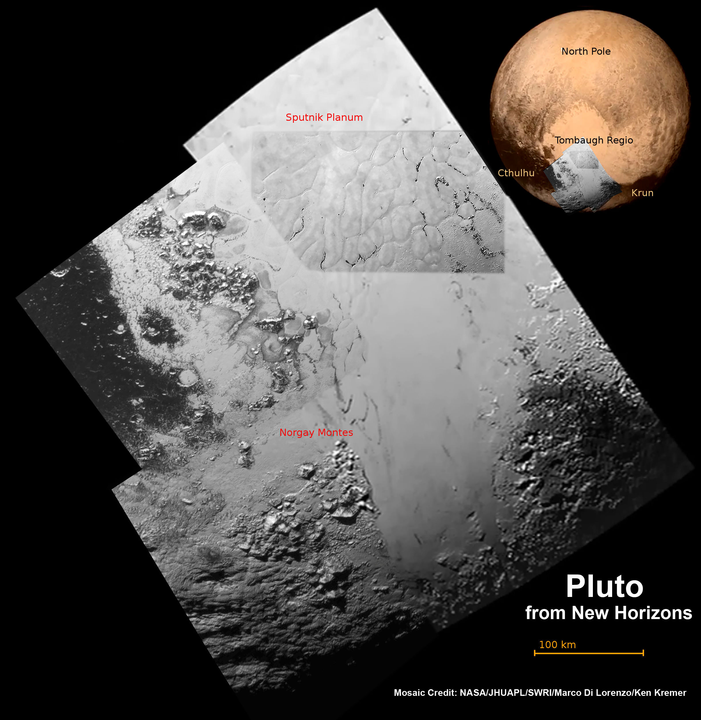
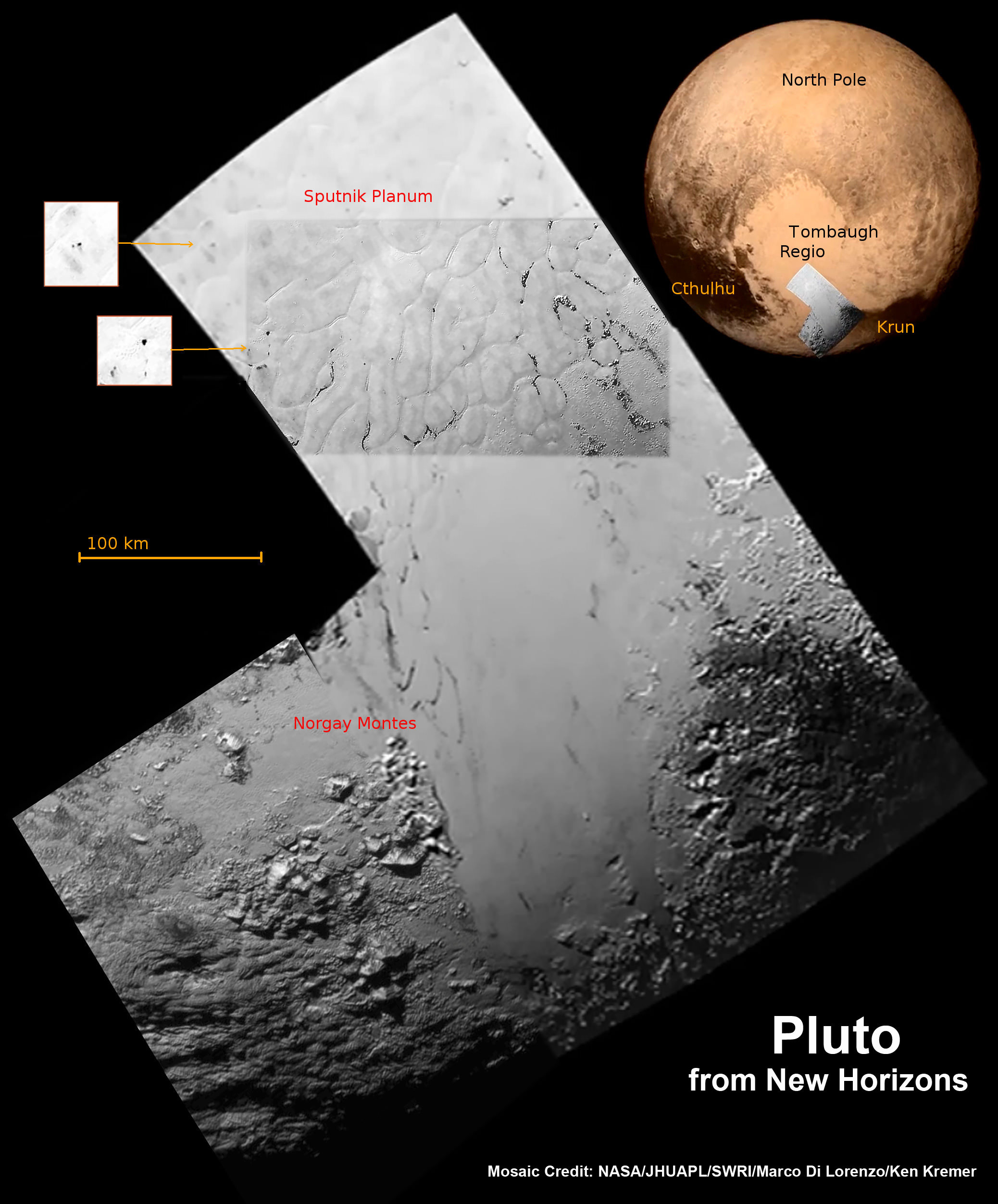
Hi Res mosaic of ‘Tombaugh Regio’ shows the heart-shaped region on Pluto and focuses on icy mountain ranges of ‘Norgay Montes’ and ice plains of ‘Sputnik Planum.’ The new mosaic combines highest resolution imagery captured by NASA’s New Horizons LORRI imager during history making closest approach flyby on July 14, 2015, draped over a wider, lower resolution view of Tombaugh Regio.   Inset at left shows possible wind streaks.  Inset at right shows global view of Pluto with location of huge heart-shaped region in context.  Annotated with place names.  Credit: NASA/JHUAPL/SWRI/ Marco Di Lorenzo/Ken Kremer/kenkremer.com
Hi Res mosaic of ‘Tombaugh Regio’ shows the heart-shaped region on Pluto and focuses on icy mountain ranges of ‘Norgay Montes’ and ice plains of ‘Sputnik Planum.’ The new mosaic combines highest resolution imagery captured by NASA’s New Horizons LORRI imager during history making closest approach flyby on July 14, 2015, draped over a wider, lower resolution view of Tombaugh Regio. Inset at left shows possible wind streaks. Inset at right shows global view of Pluto with location of huge heart-shaped region in context. Annotated with place names. Credit: NASA/JHUAPL/SWRI/ Marco Di Lorenzo/Ken Kremer/kenkremer.com

Faulty Support Strut Likely Caused SpaceX Falcon 9 Rocket Failure: Elon Musk

The SpaceX Falcon 9 rocket and Dragon cargo spaceship dazzled in the moments after liftoff from Cape Canaveral, Florida, on June 28, 2015 but were soon doomed to a sudden catastrophic destruction barely two minutes later in the inset photo (left). Composite image includes up close launch photo taken from pad camera set at Space Launch Complex 40 at Cape Canaveral and mid-air explosion photo taken from the roof of the Vehicle Assembly Building (VAB) at NASA’s Kennedy Space Center, Florida as rocket was streaking to the International Space Station (ISS) on CRS-7 cargo resupply mission. Credit: Ken Kremer/kenkremer.com

The in-flight failure of a critical support strut inside the second stage liquid oxygen tank holding a high pressure helium tank in the Falcon 9 rocket, is the likely cause of the failed SpaceX launch three weeks ago on June 28, revealed SpaceX CEO and chief designer Elon Musk during a briefing for reporters held today, July 20, to explain why the critical cargo delivery run for NASA to the space station suddenly turned into a total disaster after a promising start.

The commercial booster and its cargo Dragon payload were unexpectedly destroyed by an overpressure event 139 seconds after a picture perfect blastoff from Space Launch Complex 40 at Cape Canaveral Air Force Station in Florida on June 28 at 10:21 a.m. EDT.

Musk emphasized that the failure analysis is still “preliminary” and an “initial assessment” based on the investigation thus far. SpaceX has led the investigation efforts under the oversight of the FAA with participation from prime customers NASA and the U.S. Air Force.

The root cause appears to be that the second stage strut holding the high pressure helium tank inside the 2nd stage broke at a bolt – far below its design specification and thereby allowing the tank to break free and swing away.

“The strut that we believe failed was designed and certified to handle 10,000 lbs of force, but failed at 2,000 lbs, a five-fold difference,” Musk explained.

“During acceleration of the rocket to 3.2 G’s, the strut holding down the helium tank failed. Helium was released, causing the over pressurization event.”

To date no other issues have been identified as possible failure modes, Musk elaborated.

The helium tanks are pressurized to 5500 psi and were breached during the over pressurization. The purpose of the helium tanks is to pressurize the first and second stage propellant tanks.

SpaceX Falcon 9 rocket explodes about 2 minutes after liftoff from Cape Canaveral Air Force Station in Florida on June 28, 2015.  Credit: Ken Kremer/kenkremer.com
SpaceX Falcon 9 rocket explodes about 2 minutes after liftoff from Cape Canaveral Air Force Station in Florida on June 28, 2015. Credit: Ken Kremer/kenkremer.com

“We tested several hundred struts. On the outside they looked normal. But inside there was a problem,” Musk explained

“Detailed close-out photos of stage construction show no visible flaws or damage of any kind,” according to a SpaceX statement.

The struts are produced by an outside vendor that Musk would not identify. He added that in the future, SpaceX will likely choose a different vendor to manufacture the struts.

He said the struts were made from a type of stainless steel and would also likely be redesigned.

“The material of construction will be changed to Inconel,” Musk told me in response to a question.

Hundreds of the original type struts have been used to date on the first and second stages of the Falcon 9 with no issues. In the future, they will also be independently certified for use, by an outside contractor instead of the vendor.

The nine first stage Merlin 1D engines of the Falcon 9 were still firing nominally during the start of the mishap, said Musk. The first stage had nearly completed its planned firing duration when the explosion took place.

“The event happened very quickly, within 0.893 seconds,” Musk stated, from the first indication of an issue to loss of all telemetry.

“Preliminary analysis suggests the overpressure event in the upper stage liquid oxygen tank was initiated by a flawed piece of support hardware (a “strut”) inside the second stage,” noted SpaceX in a statement.

Video caption: Launch video of the CRS-7 launch on June 28, 2015 from a remote camera placed at Launch Complex 40. The launch would fail around two minutes later. Credit: Alex Polimeni/Spaceflight Now

The blastoff of the Dragon CRS-7 cargo mission for NASA was the first failure of the SpaceX Falcon 9 rocket after 18 straight successes and the firms first launch mishap since the failure of a Falcon 1 in 2008.

The SpaceX CRS-7 Dragon was loaded with over 4,000 pounds (1987 kg) of research experiments, an EVA spacesuit, water filtration equipment, spare parts, gear, computer equipment, high pressure tanks of oxygen and nitrogen supply gases, food, water and clothing for the astronaut and cosmonaut crews comprising Expeditions 44 and 45.

Umbilicals away and detaching from SpaceX Falcon 9 launch  from Cape Canaveral, Florida, on June 28, 2015 that was doomed to disaster soon thereafter.  Credit: Ken Kremer/kenkremer.com
Umbilicals away and detaching from SpaceX Falcon 9 launch from Cape Canaveral, Florida, on June 28, 2015 that was doomed to disaster soon thereafter. Credit: Ken Kremer/kenkremer.com

The Dragon cargo freighter survived the explosion but was destroyed when it impacted the Atlantic Ocean.

“But the Dragon might have been saved if the parachutes had been deployed,” said Musk.

Unfortunately the software required to deploy the parachute was not loaded onboard.

“The new software required to deploy the parachutes will be included on all future Dragons, V1 and V2,” said Musk, referring to the cargo and crew versions of the SpaceX Dragon spaceship.

SpaceX Falcon 9 rocket and Dragon resupply spaceship explode about 2 minutes after liftoff from Cape Canaveral Air Force Station in Florida on June 28, 2015. Credit: Ken Kremer/kenkremer.com

The NASA cargo was valued at about $110 million. The launch itself was not insured.

The investigation board is reviewing data from over 3,000 telemetry channels as well as video and physical debris, he noted.

The next launch of a Falcon 9 will be postponed at least a few months until “no earlier than September” Musk indicated.

Two Falcon 9 launches had been set for August from Vandenberg AFB and Cape Canaveral. And the next launch to the ISS had been slated for September on the Dragon CRS-8 mission.

Musk said the next payload to be launched aboard a Falcon 9 has yet to be determined.

Starting in 2017, the Falcon 9 will launch astronauts to the ISS aboard the Crew Dragon.

Overall CRS-7 was the seventh SpaceX commercial resupply services mission and the eighth trip by a Dragon spacecraft to the station since 2012.

CRS-7 marked the company’s seventh operational resupply mission to the ISS under a $1.6 Billion contract with NASA to deliver 20,000 kg (44,000 pounds) of cargo to the station during a dozen Dragon cargo spacecraft flights through 2016 under NASA’s original Commercial Resupply Services (CRS) contract.

Stay tuned here for Ken’s continuing Earth and planetary science and human spaceflight news.

Ken Kremer

SpaceX founder and CEO Elon Musk briefs reporters, including Universe Today, in Cocoa Beach, FL, during prior SpaceX Falcon 9 rocket blastoff from Cape Canaveral, FL. Credit: Ken Kremer/kenkremer.com

………….

Learn more about SpaceX, ULA, Mars rovers, Orion, Antares, MMS, NASA missions and more at Ken’s upcoming outreach events:

July 21/22: “SpaceX, Orion, Commercial crew, Curiosity explores Mars, MMS, Antares and more,” Kennedy Space Center Quality Inn, Titusville, FL, evenings/afternoon for July 22 Delta IV launch of USAF WGS-7 satellite

Pluto’s Heart of the Heart Swathed in Newly Discovered Icy Mountains and Vast Plains

Hi Res mosaic of ‘Tombaugh Regio’ shows the heart-shaped region on Pluto and focuses on icy mountain ranges of ‘Norgay Montes’ and ice plains of ‘Sputnik Planum.’ The new mosaic combines highest resolution imagery captured by NASA’s New Horizons LORRI imager during history making closest approach flyby on July 14, 2015, draped over a wider, lower resolution view of Tombaugh Regio. Inset at left shows possible wind streaks. Inset at right shows global view of Pluto with location of huge heart-shaped region in context. Annotated with place names. Credit: NASA/JHUAPL/SWRI/ Marco Di Lorenzo/Ken Kremer/kenkremer.com

APPLIED PHYSICS LABORATORY, LAUREL, MD – The highest resolution images ever taken of Pluto by humanity’s first spacecraft ever to visit the last planet in our solar system revealed unanticipated new discoveries of ice mountains as tall as the Rockies and vast craterless plains spanning hundreds of miles (kilometers) across – are now shown in our newly created context mosaic (featured above and below) of the heart-shaped ‘Tombaugh Regio’ area that dominates the alien planet’s surface.

These stunning and astoundingly young features only now unveiled on Pluto’s surface were created in very recent times, geologically speaking said top scientists leading NASA’s resounding successful New Horizons mission, at a media briefing on July 17.

This first high resolution surface mosaic was created from a newly unveiled series of black and white images centered in the Heart of Pluto’s huge ‘Heart, including the ice mountains of ‘Sputnik Planum’ and icy plains of ‘Norgay Montes.’

They were captured by New Horizons’ high resolution Long Range Reconnaissance Imager (LORRI) on July 14 as the probe barreled past the Pluto-Charon binary planet system only four days ago on Tuesday, July 14, at over 31,000 mph (49,600 kph).

These highest resolution LORRI images focused on the “Heart of the Heart” of Pluto have now been stitched into a mosaic by the image processing team of Marco Di Lorenzo and Ken Kremer.

Pluto’s bright heart-shaped region has now been informally renamed “Tombaugh Regio,’ announced John Spencer, New Horizons science team co-investigator at the post flyby media briefing on July 15.

The mosaic of Pluto’s ‘Tombaugh Regio’ is based on the initial imagery released so far as of July 17.

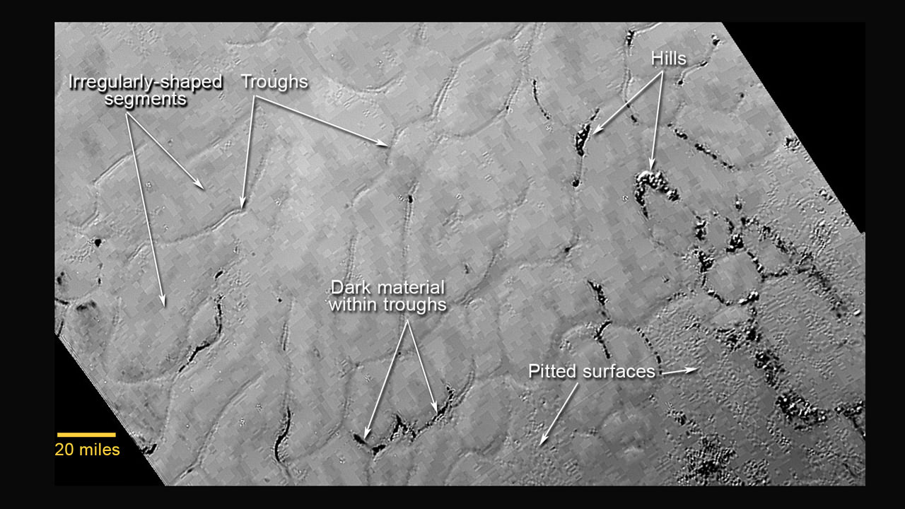
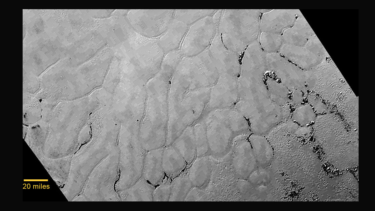
This annotated view of a portion of Pluto’s Sputnik Planum (Sputnik Plain), named for Earth’s first artificial satellite, shows an array of enigmatic features. The surface appears to be divided into irregularly shaped segments that are ringed by narrow troughs, some of which contain darker materials. Features that appear to be groups of mounds and fields of small pits are also visible. This image was acquired by the Long Range Reconnaissance Imager (LORRI) on July 14 from a distance of 48,000 miles (77,000 kilometers). Features as small as a half-mile (1 kilometer) across are visible. Credits: NASA/JHUAPL/SWRI

A pair of high resolution LORRI images was aimed at areas now informally named Norgay Montes (Norgay Mountains) and Sputnik Planum (Sputnik Plain).

Norgay Montes is informally named for Tenzing Norgay, one of the first two humans to reach the summit of Mount Everest, along with Sir Edmund Hillary. Sputnik Planum is informally named for Earth’s first artificial satellite launched by the Soviet Union in 1957.

The two LORRI images are draped over a wider, lower resolution view of Tombaugh Regio – in annotated and unannotated versions. This is highest resolution currently available.

To the left of the mosaic are two small inserts showing possible “wind streaks” say the researchers.

To the right of the mosaic is a global view of Pluto showing the location of Tombaugh Regio and also outlined to show the precise location of the high resolution LORRI mosaic.

Hi Res mosaic of ‘Tombaugh Regio’ shows the heart-shaped region on Pluto and focuses on icy mountain ranges of ‘Norgay Montes’ and ice plains of ‘Sputnik Planum.’ The new mosaic combines highest resolution imagery captured by NASA’s New Horizons LORRI imager during history making closest approach flyby on July 14, 2015.   Inset at left shows possible wind streaks.  Inset at right shows global view of Pluto with location of huge heart-shaped region in context.  Credit: NASA/JHUAPL/SWRI/ Marco Di Lorenzo/Ken Kremer/kenkremer.com
Hi Res mosaic of ‘Tombaugh Regio’ shows the heart-shaped region on Pluto and focuses on icy mountain ranges of ‘Norgay Montes’ and ice plains of ‘Sputnik Planum.’ The new mosaic combines highest resolution imagery captured by NASA’s New Horizons LORRI imager during history making closest approach flyby on July 14, 2015. Inset at left shows possible wind streaks. Inset at right shows global view of Pluto with location of huge heart-shaped region in context. Credit: NASA/JHUAPL/SWRI/ Marco Di Lorenzo/Ken Kremer/kenkremer.com

The LORRI images were taken from a distance of 48,000 miles (77,000 kilometers) from the surface of the planet about 1.5 hours prior to the closest approach at 7:49 a.m. EDT on July 14. The images easily resolve structures smaller than a mile across.

The frozen region of Norgay Montes is situated north of Pluto’s icy mountain range at Sputnik Planum.

“This terrain is not easy to explain,” said Jeff Moore, leader of the New Horizons Geology, Geophysics and Imaging Team (GGI) at NASA’s Ames Research Center in Moffett Field, California.

“The discovery of vast, craterless, very young plains on Pluto exceeds all pre-flyby expectations.”

“The landscape is astoundingly amazing. There are a few ancient impact craters on Pluto. But other areas like “Tombaugh Regio” show no craters. The landform change processes are occurring into current geologic times.”

“There are no impact craters in a frozen area north of Pluto’s icy mountains we are now informally calling ‘Sputnik Planum’ after Earth’s first artificial satellite.”

New close-up images of a region near Pluto’s equator reveal a giant surprise -- a range of youthful mountains rising as high as 11,000 feet (3,500 meters) above the surface of the icy body.  Credits: NASA/JHU APL/SwRI
New close-up images of a region near Pluto’s equator reveal a giant surprise — a range of youthful mountains rising as high as 11,000 feet (3,500 meters) above the surface of the icy body. Credits: NASA/JHU APL/SwRI

‘Sputnik Planum’ is composed of a broken surface of irregularly-shaped segments. The polygonal shaped areas are roughly 12 miles (20 kilometers) across, bordered by what appear to be shallow troughs based on a quick look at the data.

The mountain ranges height rival those of the Rockies, says Moore.

The new LORRI close-ups show the icy mountain range has peaks jutting as high as 11,000 feet (3,500 meters) above the surface, announced John Spencer, New Horizons science team co-investigator at the media briefing.

“It’s a very young surface, probably formed less than 100 million years old,’ said Spencer. “It may be active now.”

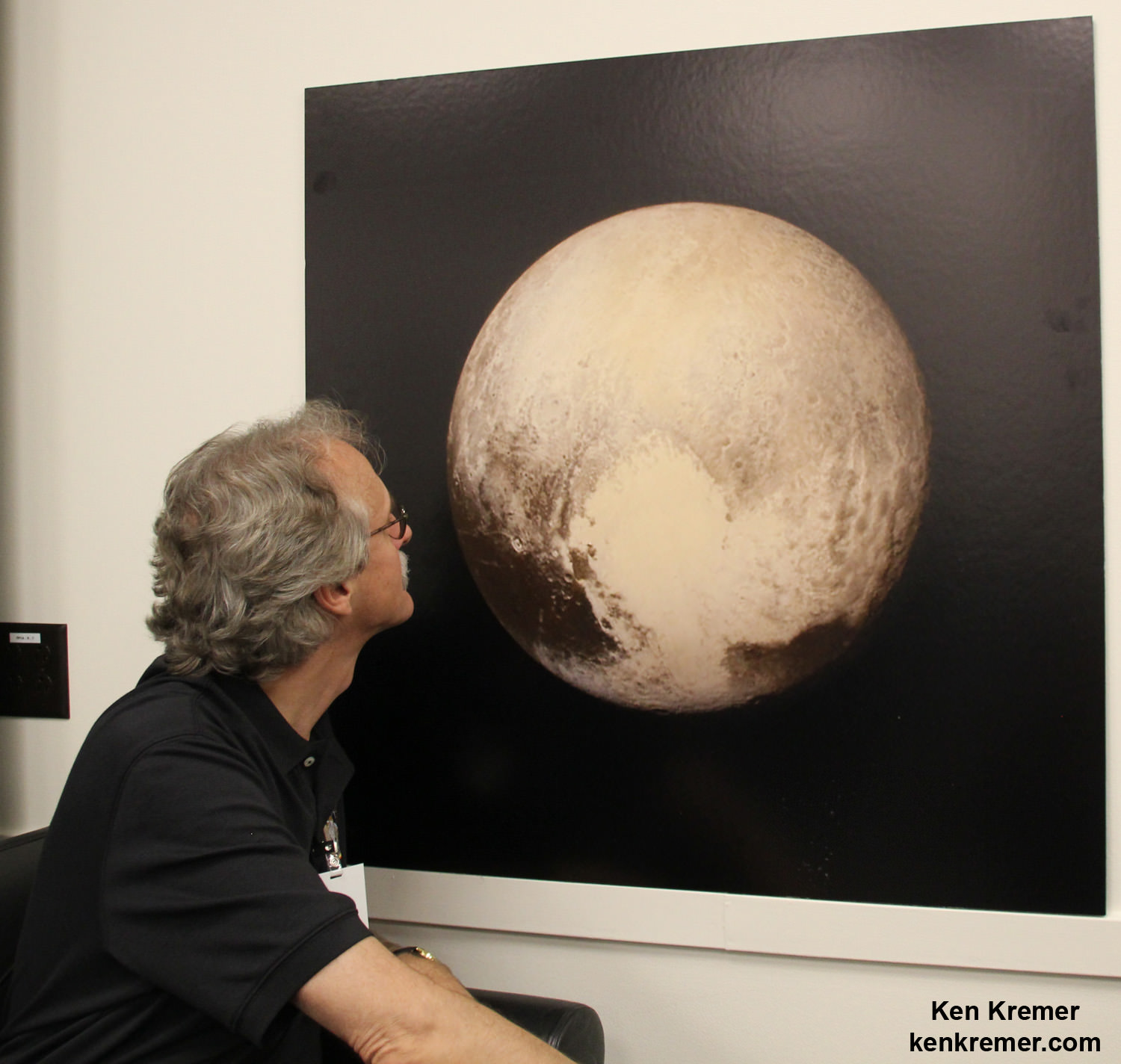
New Horizons science team co-investigator John Spencer examines print of the newest Pluto image taken on July 13, 2015 after the successful Pluto flyby. Credit: Ken Kremer/kenkremer.com

“Judging from the absence of impact craters, it’s clear that Sputnik Planum couldn’t possibly be more than 100 million years old, and possibly is still being shaped to this day by geologic processes,” noted Moore. “This could be only a week old for all we know.”

During the fast flyby encounter, the New Horizons spacecraft pointed its suite of seven science instruments exclusively on all the bodies in the Pluto system, to maximize the capture of scientific data, as quickly as possible, and store it onto its two solid state digital recorders for later playback.

A major challenge for the mission is the rather slow “downlink” transmission of data back to Mission Control on Earth. Since the average “downlink” is only about 2 kilobits per second via its two transmitters, it will take about 16 months to send all the flyby data back to Earth.

Therefore the team has carefully selected just a few of the highest resolution images and other key instrument data for quick playback. The remaining flyby data will be prioritized for streaming.

“Over 50 gigabits of data were collected during the encounter and flyby periods,” New Horizons principal investigator Alan Stern of the Southwest Research Institute, Boulder, Colorado, said during the July 17 media briefing.

“So far less than 1 gigabit of data has been returned.”

New Horizons discovered that Pluto is the biggest object in the outer solar system and thus the ‘King of the Kuiper Belt’.

The Kuiper Belt comprises the third and outermost region of worlds in our solar system.

If the spacecraft remains healthy as expected, the science team plans to target New Horizons to fly by another smaller Kuiper Belt Object (KBO) as soon as 2018.

Pluto Explored at Last. The New Horizons mission team celebrates successful flyby of Pluto in the moments after closest approach at 7:49 a.m. EDT on July 14, 2015.   New Horizons Principal Investigator Alan Stern of Southwest Research Institute (SwRI), Boulder, CO., left, Johns Hopkins University Applied Physics Laboratory (APL) Director Ralph Semmel, center, and New Horizons Co-Investigator Will Grundy Lowell Observatory hold an enlarged print of an U.S. stamp with their suggested update after Pluto became the final planet in our solar system to be explored by an American space probe (crossing out the words ‘not yet’) - at the Johns Hopkins University Applied Physics Laboratory (APL) in Laurel, Maryland.  Credit: Ken Kremer/kenkremer.com
Pluto Explored at Last. The New Horizons mission team celebrates successful flyby of Pluto in the moments after closest approach at 7:49 a.m. EDT on July 14, 2015. New Horizons Principal Investigator Alan Stern of Southwest Research Institute (SwRI), Boulder, CO., left, Johns Hopkins University Applied Physics Laboratory (APL) Director Ralph Semmel, center, and New Horizons Co-Investigator Will Grundy Lowell Observatory hold an enlarged print of an U.S. stamp with their suggested update after Pluto became the final planet in our solar system to be explored by an American space probe (crossing out the words ‘not yet’) – at the Johns Hopkins University Applied Physics Laboratory (APL) in Laurel, Maryland. Credit: Ken Kremer/kenkremer.com

Watch for Ken’s continuing coverage of the Pluto flyby. He was onsite reporting live on the flyby and media briefings for Universe Today from the Johns Hopkins University Applied Physics Laboratory (APL), in Laurel, Md.

Stay tuned here for Ken’s continuing Earth and planetary science and human spaceflight news.

Ken Kremer

NASA Associate Administrator for the Science Mission Directorate John Grunsfeld, left, New Horizons Principal Investigator Alan Stern of Southwest Research Institute (SwRI), Boulder, CO, second from left, New Horizons Mission Operations Manager Alice Bowman of the Johns Hopkins University Applied Physics Laboratory (APL), second from right, and New Horizons Project Manager Glen Fountain of APL, right, are seen at the conclusion of a press conference after the team received confirmation from the spacecraft that it has completed the flyby of Pluto, Tuesday, July 14, 2015 at the Johns Hopkins University Applied Physics Laboratory (APL) in Laurel, Maryland. Credit:  Ken Kremer/kenkremer.com
NASA Associate Administrator for the Science Mission Directorate John Grunsfeld, left, New Horizons Principal Investigator Alan Stern of Southwest Research Institute (SwRI), Boulder, CO, second from left, New Horizons Mission Operations Manager Alice Bowman of the Johns Hopkins University Applied Physics Laboratory (APL), second from right, and New Horizons Project Manager Glen Fountain of APL, right, are seen at the conclusion of a press conference after the team received confirmation from the spacecraft that it has completed the flyby of Pluto, Tuesday, July 14, 2015 at the Johns Hopkins University Applied Physics Laboratory (APL) in Laurel, Maryland. Credit: Ken Kremer/kenkremer.com

Youthful Frozen Plains Cover Pluto’s Big ‘Heart’ – Spectacular New Images from New Horizons

This annotated view of a portion of Pluto’s Sputnik Planum (Sputnik Plain), named for Earth’s first artificial satellite, shows an array of enigmatic features. The surface appears to be divided into irregularly shaped segments that are ringed by narrow troughs, some of which contain darker materials. Features that appear to be groups of mounds and fields of small pits are also visible. This image was acquired by the Long Range Reconnaissance Imager (LORRI) on July 14 from a distance of 48,000 miles (77,000 kilometers). Features as small as a half-mile (1 kilometer) across are visible. Credits: NASA/JHUAPL/SWRI

This annotated view of a portion of Pluto’s Sputnik Planum (Sputnik Plain), named for Earth’s first artificial satellite, shows an array of enigmatic features. The surface appears to be divided into irregularly shaped segments that are ringed by narrow troughs, some of which contain darker materials. Features that appear to be groups of mounds and fields of small pits are also visible. This image was acquired by the Long Range Reconnaissance Imager (LORRI) on July 14 from a distance of 48,000 miles (77,000 kilometers). Features as small as a half-mile (1 kilometer) across are visible. Credits: NASA/JHUAPL/SWRI
See 3 image mosaic below[/caption]

A vast, hundreds of miles wide craterless plain of Plutonian ice no more than 100 million years old and centered amidst Pluto’s big ‘heart’ was unveiled in spectacular new imagery taken by NASA’s resounding successful New Horizons mission, during its history making rapid transit through the Pluto-Charon binary planet system barely three days ago, on Tuesday, July 14.

The jaw dropping new imagery of young plains of water ice was publicly released today, July 17, by NASA and scientists leading the New Horizons mission during a media briefing, and has already resulted in ground breaking new scientific discoveries at the last planet in our solar system to be visited by a spacecraft from Earth.

“We have now visited every planet in our solar system with American spacecraft,” said NASA Administrator Charles Bolden. “These findings are already causing us to rethink the dynamics of interior geologic processes.”

New data and dazzling imagery are now from streaming back some 3 billion miles across interplanetary space to mission control on Earth and researchers eagerly awaiting the fruits of more than two decades of hard labor to get to this once-in-a-lifetime opportunity.

“I can’t wait for the new discoveries!” exclaimed Bolden at today’s media briefing.

“Over 50 gigabits of data were collected during the encounter and flyby periods,” New Horizons principal investigator Alan Stern of the Southwest Research Institute, Boulder, Colorado, said during the media briefing.

“So far less than 1 gigabit of data has been returned.”

It will take some 16 months for all the Pluto flyby data to be transmitted back to Earth.

And the team has not been disappointed because the results so far shows Pluto to possess tremendously varied terrain that “far exceed our expectations.”

Video Caption: In the center left of Pluto’s vast heart-shaped feature – informally named “Tombaugh Regio” – lies a vast, craterless plain that appears to be no more than 100 million years old, and is possibly still being shaped by geologic processes. This frozen region is north of Pluto’s icy mountains and has been informally named Sputnik Planum (Sputnik Plain), after Earth’s first artificial satellite. Credits: NASA/JHUAPL/SWRI

Two new high resolution images captured by the probes Long Range Reconnaissance Imager (LORRI) on July 14 were released today and taken from a distance of 48,000 miles (77,000 kilometers). Features as small as one-half mile (1 kilometer) across are visible in the images – shown above and below.

They were snapped from frozen region lying north of Pluto’s icy mountains, in the center-left of the heart feature, informally named “Tombaugh Regio” (Tombaugh Region) after Clyde Tombaugh, who discovered Pluto in 1930.

“This terrain is not easy to explain,” said Jeff Moore, leader of the New Horizons Geology, Geophysics and Imaging Team (GGI) at NASA’s Ames Research Center in Moffett Field, California.

“The discovery of vast, craterless, very young plains on Pluto exceeds all pre-flyby expectations.”

“The landscape is astounding. There are a few ancient impact craters on Pluto. But other areas like “Tombaugh Regio” show no craters. The landform change processes are occurring into current geologic times.”

“There are no impact craters in a frozen area north of Pluto’s icy mountains we are now informally calling ‘Sputnik Planum’ after Earth’s first artificial satellite.”

‘Sputnik Planum’ is composed of a broken surface of irregularly-shaped segments. The polygonal shaped areas are roughly 12 miles (20 kilometers) across, bordered by what appear to be shallow troughs based on a quick look at the data.

Notably, some of the clumps are filled with mysterious darker material. Hills are also visible in some areas, which may have been pushed up. Etched areas on the surface may have been formed by sublimation process where the water ice turns directly from the solid to the gas phase due to the extremely negligible atmosphere pressure.

In some places there are also streaks that may have formed from windblown processes and pitted areas.

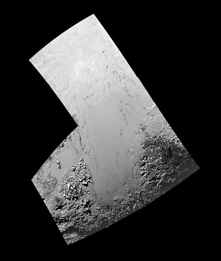
Three image mosaic of ‘Tombaugh Regio,’ Pluto’s heart-shaped region,  combining highest resolution imagery captured by NASA’s New Horizons LORRI imager during closest approach flyby on July 14, 2015.   Credits: NASA/JHUAPL/SWRI.  Additional processing Ken Kremer/Marco Di Lorenzo
Three image mosaic of ‘Tombaugh Regio,’ Pluto’s heart-shaped region, combining highest resolution imagery captured by NASA’s New Horizons LORRI imager during closest approach flyby on July 14, 2015. Credits: NASA/JHUAPL/SWRI. Additional processing Ken Kremer/Marco Di Lorenzo

“It’s just pure coincidence that we got the highest resolution data at Sputnik Planum which is of the most interest scientifically,” Moore noted.

Moore indicated that the team is working on a pair of theories as to how these polygonal segments were formed.

“The irregular shapes may be the result of the contraction of surface materials, similar to what happens when mud dries. Alternatively, they may be a product of convection, similar to wax rising in a lava lamp. On Pluto, convection would occur within a surface layer of frozen carbon monoxide, methane and nitrogen, driven by the scant warmth of Pluto’s interior,” Moore explained.

Pluto’s polygons look remarkably similar to the Martian polygons upon which NASA’s Phoenix lander touched down on in 2008 and dug into. Perhaps they were formed by similar mechanisms or difference ones, contraction or convection, Moore told me during the briefing.

As of yesterday, New Horizons spacecraft completed and exited the Pluto encounter phase, said Stern. “We are now collecting departure science.”

New Horizons is already over 3 million miles beyond Pluto and heading to its next yet to be determined target in the Kuiper Belt.

“With the flyby in the rearview mirror, a decade-long journey to Pluto is over –but, the science payoff is only beginning,” said Jim Green, director of Planetary Science at NASA Headquarters in Washington.

“Data from New Horizons will continue to fuel discovery for years to come.”

Counting down to less than 3 minutes from New Horizons closest approach to Pluto, Jim Green, NASA Planetary Science Division Director, addresses the team, guests and media on Tuesday, July 14, 2015 at the Johns Hopkins University Applied Physics Laboratory (APL) in Laurel, Maryland. Credit: Ken Kremer/kenkremer.com

Stay tuned here for Ken’s continuing Earth and planetary science and human spaceflight news.

Ken Kremer

Pluto Explored at Last. The New Horizons mission team celebrates successful flyby of Pluto in the moments after closest approach at 7:49 a.m. EDT on July 14, 2015.   New Horizons Principal Investigator Alan Stern of Southwest Research Institute (SwRI), Boulder, CO., left, Johns Hopkins University Applied Physics Laboratory (APL) Director Ralph Semmel, center, and New Horizons Co-Investigator Will Grundy Lowell Observatory hold an enlarged print of an U.S. stamp with their suggested update after Pluto became the final planet in our solar system to be explored by an American space probe (crossing out the words ‘not yet’) - at the Johns Hopkins University Applied Physics Laboratory (APL) in Laurel, Maryland.  Credit: Ken Kremer/kenkremer.com
Pluto Explored at Last
The New Horizons mission team celebrates successful flyby of Pluto in the moments after closest approach at 7:49 a.m. EDT on July 14, 2015. New Horizons Principal Investigator Alan Stern of Southwest Research Institute (SwRI), Boulder, CO., left, Johns Hopkins University Applied Physics Laboratory (APL) Director Ralph Semmel, center, and New Horizons Co-Investigator Will Grundy Lowell Observatory hold an enlarged print of an U.S. stamp with their suggested update after Pluto became the final planet in our solar system to be explored by an American space probe (crossing out the words ‘not yet’) – at the Johns Hopkins University Applied Physics Laboratory (APL) in Laurel, Maryland. Credit: Ken Kremer/kenkremer.com
In the center left of Pluto’s vast heart-shaped feature – informally named “Tombaugh Regio” - lies a vast, craterless plain that appears to be no more than 100 million years old, and is possibly still being shaped by geologic processes. This frozen region is north of Pluto’s icy mountains and has been informally named Sputnik Planum (Sputnik Plain), after Earth’s first artificial satellite. The surface appears to be divided into irregularly-shaped segments that are ringed by narrow troughs. Features that appear to be groups of mounds and fields of small pits are also visible. This image was acquired by the Long Range Reconnaissance Imager (LORRI) on July 14 from a distance of 48,000 miles (77,000 kilometers). Features as small as one-half mile (1 kilometer) across are visible. The blocky appearance of some features is due to compression of the image. Credits: NASA/JHUAPL/SWRI
In the center left of Pluto’s vast heart-shaped feature – informally named “Tombaugh Regio” – lies a vast, craterless plain that appears to be no more than 100 million years old, and is possibly still being shaped by geologic processes. This frozen region is north of Pluto’s icy mountains and has been informally named Sputnik Planum (Sputnik Plain), after Earth’s first artificial satellite. The surface appears to be divided into irregularly-shaped segments that are ringed by narrow troughs. Features that appear to be groups of mounds and fields of small pits are also visible. This image was acquired by the Long Range Reconnaissance Imager (LORRI) on July 14 from a distance of 48,000 miles (77,000 kilometers). Features as small as one-half mile (1 kilometer) across are visible. Credits: NASA/JHUAPL/SWRI

11713794_669270766536791_5453013284858242275_o

Mysterious Mountain Revealed in First Close-up of Pluto’s Moon Charon

This new image of an area on Pluto's largest moon Charon has a captivating feature -- a depression with a peak in the middle, shown here in the upper left corner of the inset. The image shows an area approximately 240 miles (390 kilometers) from top to bottom, including few visible craters. The image was taken at approximately 6:30 a.m. EDT on July 14, 2015, about 1.5 hours before closest approach to Pluto, from a range of 49,000 miles (79,000 kilometers). Credits: NASA-JHUAPL-SwRI

This new image of an area on Pluto’s largest moon Charon has a captivating feature — a depression with a peak in the middle, shown here in the upper left corner of the inset. The image shows an area approximately 240 miles (390 kilometers) from top to bottom, including few visible craters. The image was taken at approximately 6:30 a.m. EDT on July 14, 2015, about 1.5 hours before closest approach to Pluto, from a range of 49,000 miles (79,000 kilometers). Credits: NASA-JHUAPL-SwRI
Story updated[/caption]

APPLIED PHYSICS LABORATORY, LAUREL, MD – A mysterious mountain in the middle of a moat on Pluto’s biggest moon Charon, has captivated and baffled scientists leading NASA’s New Horizons mission which made history when it became the first spacecraft to visit our solar system’s most distant planet barely two days ago on Tuesday morning, July 14, 2015.

NASA released the first close-up image of Charon today (July 16), shown above, and it has the geology team scratching their heads in amazement and wonder. They can’t figure out the nature of a big mountain set inside a moat.

The new image shows a depression with a mountain peak in the middle.

“The most intriguing feature is a large mountain sitting in a moat,” said Jeff Moore with NASA’s Ames Research Center, Moffett Field, California, who leads New Horizons’ Geology, Geophysics and Imaging team. “This is a feature that has geologists stunned and stumped.”

The location of the “mountain in a moat” is shown in the inset of a global view of Charon.

The new high resolution image of Charon was taken at approximately 6:30 a.m. EDT (10:30 UTC), barely an hour and a half before the piano-shaped spacecraft’s closest approach to Pluto on July 14, 2015, from a range of only 49,000 miles (79,000 kilometers).

The image was captured by New Horizons’ high resolution Long Range Reconnaissance Imager (LORRI).

Pluto Explored at Last. The New Horizons mission team celebrates successful flyby of Pluto in the moments after closest approach at 7:49 a.m. EDT on July 14, 2015.   New Horizons Principal Investigator Alan Stern of Southwest Research Institute (SwRI), Boulder, CO., left, Johns Hopkins University Applied Physics Laboratory (APL) Director Ralph Semmel, center, and New Horizons Co-Investigator Will Grundy Lowell Observatory hold an enlarged print of an U.S. stamp with their suggested update after Pluto became the final planet in our solar system to be explored by an American space probe (crossing out the words ‘not yet’) - at the Johns Hopkins University Applied Physics Laboratory (APL) in Laurel, Maryland.  Credit: Ken Kremer/kenkremer.com
Pluto Explored at Last
The New Horizons mission team celebrates successful flyby of Pluto in the moments after closest approach at 7:49 a.m. EDT on July 14, 2015. New Horizons Principal Investigator Alan Stern of Southwest Research Institute (SwRI), Boulder, CO., left, Johns Hopkins University Applied Physics Laboratory (APL) Director Ralph Semmel, center, and New Horizons Co-Investigator Will Grundy Lowell Observatory hold an enlarged print of an U.S. stamp with their suggested update after Pluto became the final planet in our solar system to be explored by an American space probe (crossing out the words ‘not yet’) – at the Johns Hopkins University Applied Physics Laboratory (APL) in Laurel, Maryland. Credit: Ken Kremer/kenkremer.com

A much sharper view is yet to come, because the image is heavily compressed.

“Sharper versions are anticipated when the full-fidelity data from New Horizons’ Long Range Reconnaissance Imager (LORRI) are returned to Earth,” say NASA officials.

Altogether it will take 16 months to transmit all the data collected by New Horizons at the Pluto system.

The area in the LORRI image comprises an area approximately 240 miles (390 kilometers) from top to bottom.

Crisp new view of Pluto’s largest moon, Charon shows a swath of cliffs and troughs stretches about 600 miles (1,000 kilometers) from left to right, suggesting widespread fracturing of Charon’s crust, likely a result of internal processes. At upper right, along the moon’s curving edge, is a canyon estimated to be 4 to 6 miles (7 to 9 kilometers) deep.  Credit: NASA-JHUAPL-SwRI
Crisp new view of Pluto’s largest moon, Charon shows a swath of cliffs and troughs stretches about 600 miles (1,000 kilometers) from left to right, suggesting widespread fracturing of Charon’s crust, likely a result of internal processes. At upper right, along the moon’s curving edge, is a canyon estimated to be 4 to 6 miles (7 to 9 kilometers) deep. Credit: NASA-JHUAPL-SwRI

Notably there are few visible craters “indicating a relatively young surface that has been reshaped by geologic activity.”

And a “swath of cliffs and troughs stretching about 600 miles (1,000 kilometers) suggests widespread fracturing of Charon’s crust, likely the result of internal geological processes,” notes the team.

The Texas-sized moon measures about 750 miles (1200 kilometers) across, about half the diameter of Pluto. Pluto spans 1,471 miles (2,368 km) across.

After a nine year voyage through interplanetary space, New Horizons barreled past the Pluto system on Tuesday, July 14 for a history making first ever flyby at over 31,000 mph (49,600 kph), and survived the passage by swooping barely 7,750 miles (12,500 kilometers) above the planet’s amazingly diverse surface at 7:49 a.m. EDT. It passed about 17,900 miles (28,800 kilometers) from Charon during closest approach.

NASA Administrator Charles Bolden congratulates the New Horizons team after successful Pluto flyby on July 14, 2015, to cheering crowd at the Johns Hopkins University Applied Physics Laboratory (APL) in Laurel, Maryland, during  live NASA TV media briefing. Credit: Ken Kremer/kenkremer.com
NASA Administrator Charles Bolden congratulates the New Horizons team after successful Pluto flyby on July 14, 2015, to cheering crowd at the Johns Hopkins University Applied Physics Laboratory (APL) in Laurel, Maryland, during live NASA TV media briefing. Credit: Ken Kremer/kenkremer.com

Watch for Ken’s continuing coverage of the Pluto flyby on July 14. He was onsite reporting live on the flyby and media briefing from the Johns Hopkins University Applied Physics Laboratory (APL).

New images will be released on Friday, July 17 – watch for my story.

Stay tuned here for Ken’s continuing Earth and planetary science and human spaceflight news.

Ken Kremer

Chasms, craters, and a dark north polar region are revealed in this image of Pluto’s largest moon Charon taken by New Horizons on July 11, 2015. The annotated version includes a diagram showing Charon’s north pole, equator, and central meridian, with the features highlighted.  Credits: NASA/JHUAPL/SWRI
Chasms, craters, and a dark north polar region are revealed in this image of Pluto’s largest moon Charon taken by New Horizons on July 11, 2015. The annotated version includes a diagram showing Charon’s north pole, equator, and central meridian, with the features highlighted. Credits: NASA/JHUAPL/SWRI