Curiosity Discovers Patch of Pebbles Formed by Flowing Martian Water on Mount Sharp Trek

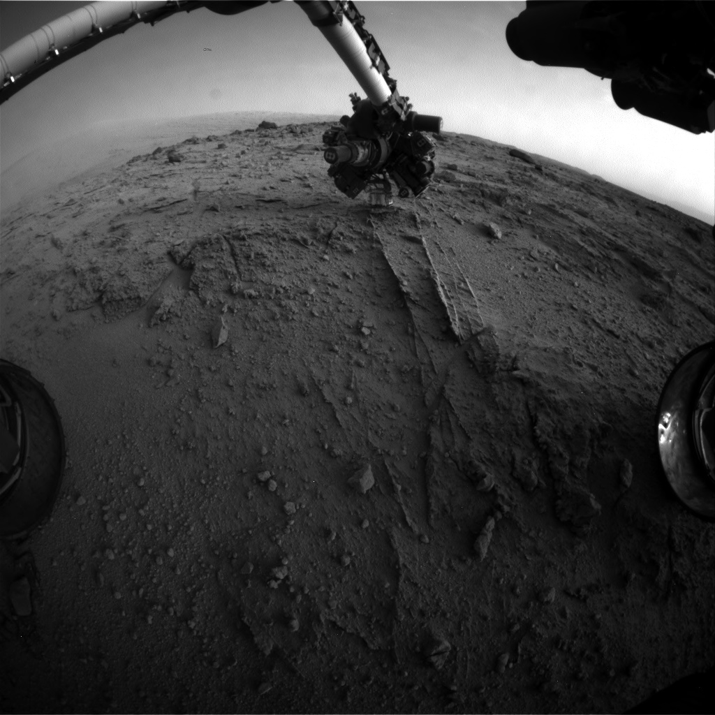
NASA's Mars rover Curiosity used a new technique, with added autonomy for the rover, in placement of the tool-bearing turret on its robotic arm during the 399th Martian day, or sol, of the mission. This image from the rover's front Hazard Avoidance Camera (Hazcam) on that sol shows the position of the turret during that process, with the Alpha Particle X-ray Spectrometer (APXS) instrument placed close to the target rock. Credit: NASA/JPL-Caltech

NASA’s Curiosity rover has discovered a new patch of pebbles formed and rounded eons ago by flowing liquid water on the Red Planet’s surface along the route she is trekking across to reach the base of Mount Sharp – the primary destination of her landmark mission.

Curiosity made the new finding at a sandstone outcrop called ‘Darwin’ during a brief science stopover spot called ‘Waypoint 1’.

Before arriving at Waypoint 1, the question was- “Did life giving water once flow here on the Red Planet?

The answer now is clearly ‘Yes!’ – And it demonstrates the teams wisdom in pausing to inspect ‘Darwin’.

The discovery at Darwin is significant because it significantly broadens the area here that was altered by flowing liquid water.
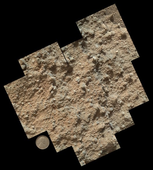
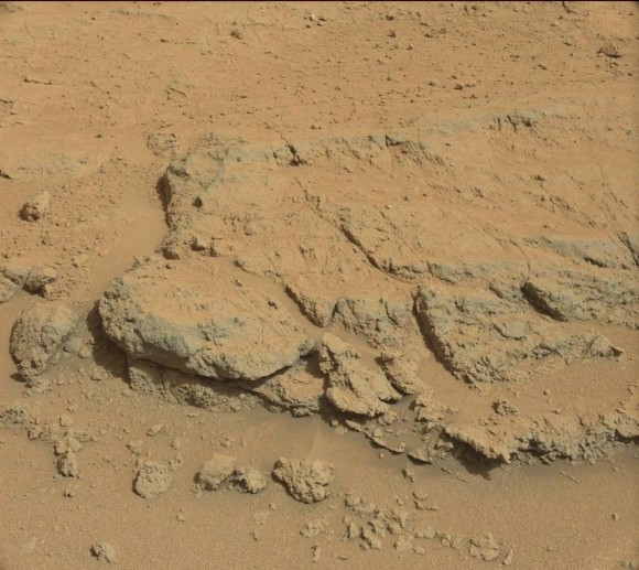
This mosaic of nine images, taken by the Mars Hand Lens Imager (MAHLI) camera on NASA's Mars rover Curiosity, shows detailed texture in a conglomerate rock bearing small pebbles and sand-size particles. Credit: NASA/JPL-Caltech/MSSS
This mosaic of nine images, taken by the Mars Hand Lens Imager (MAHLI) camera on NASA’s Mars rover Curiosity, shows detailed texture in a conglomerate rock bearing small pebbles and sand-size particles. Credit: NASA/JPL-Caltech/MSSS

The presence of water is an essential prerequisite for the formation and evolution of life.

Curiosity has arrived at Waypoint 1,” project scientist John Grotzinger, of the California Institute of Technology in Pasadena, told Universe Today at the time.

The robot pulled into ‘Waypoint 1’ on Sept. 12 (Sol 392).

“It’s a chance to study outcrops along the way,” Grotzinger told me.

This mosaic of four images taken by the Mars Hand Lens Imager (MAHLI) camera on NASA's Mars rover Curiosity shows detailed texture in a ridge that stands higher than surrounding rock. The rock is at a location called "Darwin," inside Gale Crater. Exposed outcrop at this location, visible in images from the High Resolution Imaging Science Experment (HiRISE) camera on NASA's Mars Reconnaissance Orbiter, prompted Curiosity's science team to select it as the mission's first waypoint for several days during the mission's long trek from the "Glenelg" area to Mount Sharp. Image Credit: NASA/JPL-Caltech/MSSS
This mosaic of four images taken by the Mars Hand Lens Imager (MAHLI) camera on NASA’s Mars rover Curiosity shows detailed texture in a ridge that stands higher than surrounding rock. The rock is at a location called “Darwin,” inside Gale Crater. Exposed outcrop at this location, visible in images from the High Resolution Imaging Science Experment (HiRISE) camera on NASA’s Mars Reconnaissance Orbiter, prompted Curiosity’s science team to select it as the mission’s first waypoint for several days during the mission’s long trek from the “Glenelg” area to Mount Sharp. Image Credit: NASA/JPL-Caltech/MSSS

The six wheeled rover is in the initial stages of what is sure to be an epic trek across the floor of her landing site inside the nearly 100 mile wide Gale Crater – that is dominated by humongous Mount Sharp that reaches over 3 miles (5 Kilometers) into the red Martian Sky.

“We examined pebbly sandstone deposited by water flowing over the surface, and veins or fractures in the rock,” said Dawn Sumner of University of California, Davis, a Curiosity science team member with a leadership role in planning the stop, in a NASA statement about Darwin and Waypoint 1.

“We know the veins are younger than the sandstone because they cut through it, but they appear to be filled with grains like the sandstone.”
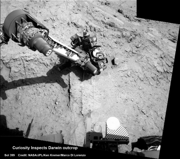
Curiosity deploys robot arm to investigate the ‘Darwin’ rock outcrop up close at ‘Waypoint 1’ on Sept 20 (Sol 399). This photo mosaic was assembled from navcam images taken on Sept 20, 2013.   Credit: NASA/JPL-Caltech/Ken Kremer/Marco Di Lorenzo
Curiosity deploys robot arm to investigate the ‘Darwin’ rock outcrop up close at ‘Waypoint 1’ on Sept 20 (Sol 399). This photo mosaic was assembled from navcam images taken on Sept 20, 2013. Credit: NASA/JPL-Caltech/Ken Kremer/Marco Di Lorenzo

Waypoint 1 is the first of up to five waypoint stops planned along the roving route that stretches about 5.3 miles (8.6 kilometers) between the “Glenelg” area, where Curiosity worked for more than six months through the first half of 2013, and the currently planned entry point at the base of Mount Sharp.

To date, the robot has now driven nearly 20% of the way towards the base of the giant layered Martian mountain she will eventually scale in search of life’s ingredients.

“Darwin is named after a geologic formation of rocks from Antarctica,” Grotzinger informed Universe Today.

‘Waypoint 1’ was an area of intriguing outcrops that was chosen based on high resolution orbital imagery taken by NASA’s Mars Reconnaissance Orbiter (MRO) circling some 200 miles overhead.

Investigation of the conglomerate rock outcrop dubbed ‘Darwin’ was the top priority of the Waypoint 1 stop.

The finding of a cache of watery mineral veins was a big added science bonus that actually indicates a more complicated story in Mars past – to the delight of the science team.

“We want to understand the history of water in Gale Crater,” Sumner said.

“Did the water flow that deposited the pebbly sandstone at Waypoint 1 occur at about the same time as the water flow at Yellowknife Bay? If the same fluid flow produced the veins here and the veins at Yellowknife Bay, you would expect the veins to have the same composition.’

“We see that the veins are different, so we know the history is complicated. We use these observations to piece together the long-term history.”

The Rover inspected Darwin from two different positions over 4 days, or Martian Sols and conducted ‘contact science’ by deploying the robotic arm and engaging the science instrument camera and spectrometer mounted on the turret at the arms terminus.

The Alpha Particle X-ray Spectrometer (APXS) collected spectral measurements of the elemental chemistry and the Mars Hand Lens Imager is a camera showing the outcrops textures, shapes and colors.

Curiosity investigates the ‘Darwin’ rock outcrop up close after arriving for a short stay at ‘Waypoint 1’ on Sept 12 (Sol 392). This photo mosaic was assembled from navcam images taken on Sept 12, 2013.   Credit: NASA/JPL-Caltech/Ken Kremer/Marco Di Lorenzo
Curiosity investigates the ‘Darwin’ rock outcrop up close after arriving for a short stay at ‘Waypoint 1’ on Sept 12 (Sol 392). This photo mosaic was assembled from navcam images taken on Sept 12, 2013. Credit: NASA/JPL-Caltech/Ken Kremer/Marco Di Lorenzo

What’s the origin of Darwin’s name?

“Darwin comes from a list of 100 names the team put together to designate rocks in the Mawson Quadrangle – Mawson is the name of a geologist who studied Antarctic geology,” Grotzinger told me.

“We’ll stay just a couple of sols at Waypoint 1 and then we hit the road again,” Grotzinger told me.

And indeed on Sept. 22, the rover departed Darwin and Waypoint 1 on a westward heading to resume the many months long journey to Mount Sharp.

Ken Kremer

…………….

Learn more about Curiosity, Mars rovers, MAVEN, Orion, Cygnus, Antares, LADEE and more at Ken’s upcoming presentations

Oct 3: “Curiosity, MAVEN and the Search for Life on Mars – (3-D)”, STAR Astronomy Club, Brookdale Community College & Monmouth Museum, Lincroft, NJ, 8 PM

Oct 8: NASA’s Historic LADEE Lunar & Antares/Cygnus ISS Rocket Launches from Virginia”; Princeton University, Amateur Astronomers Assoc of Princeton (AAAP), Princeton, NJ, 8 PM

Bazinga: Mysterious Earth Orbiting Asteroid Turns Out to be Space Junk

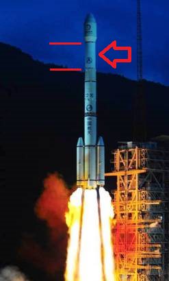
The launch of Chan'ge-2 with 3rd stage (arrowed) now known as 2010 Q (Credit CALT).

Can’t find asteroid 2010 QW1 in the Minor Planet Database? No, the “Men in Black” didn’t secretly remove this Earth-orbiting asteroid from the listing… but recent top-notch detective work by astronomers did.

The mystery of this object all started back on August 23rd of this year, when the PanSTARRS sky survey based on the summit of Haleakala on the island of Maui in Hawai’i spotted an asteroid that was given the provisional designation of 2013 QW1.

The object was in a wide-ranging orbit around the Earth, leading astronomers to wonder if it was a naturally captured asteroid or perhaps space debris from a previous launch. Either solution to the dilemma would be fascinating. Our large Moon keeps the Earth pretty well swept clear of debris, though a “second Moon,” however small, would be an interesting find. And if 2013 QW1 were to prove artificial, it just might be a piece of history.

The European Space Agency’s NEO Coordination Centre decided to take up the challenge. A call went out to track and observe the 2013 QW1, and a team led by Elisabetta Dotto of INAF-Observatorio di Roma & Maria Barucci & Davide Perna of the Observatoire de Paris managed to get time on the Italian Telescopio Nazaionale Galileo based at La Palma to obtain a spectrum of the object.

“It was a bit of a challenge, because the object was moving fast with respect to a typical NEO,” said Dr. Perna in a recent ESA press release.

The team used an instrument known as DOLORES to make the crucial measurements. DOLORES stands for the Device Optimized for LOw RESolution. The spectrum obtained in the early morning hours of August 25th shows something much brighter than your typical asteroid, but is characteristic of a painted metallic object.

The launch of Chan'ge-2 with 3rd stage (arrowed) now known as 2010 Q (Credit CALT).
The launch of Chan’ge-2 with 3rd stage (arrowed) now known as 2013 QW1 (Credit: CALT).

And thus, 2013 QW1 was removed from the ledger of NEO asteroids maintained by the IAU Minor Planet Center (MPEC). And the leading suspect? The third stage booster of a Chinese Long March 3C rocket that launched the Chang’e 2 spacecraft from Xichang, China on October 1st, 2010.

Chang’e-2 entered lunar orbit 8 days after launch, and departed on June 8th of the following year after studying and mapping the Moon. Chang’e-2 then went on to become the first spacecraft to directly reach the L2 Lagrange point 1.5 million kilometres beyond Earth from lunar orbit. The spacecraft also made the first flyby of NEO asteroid 4179 Toutatis on December 13th of last year. The probe is estimated to continue functioning into 2014, and will be used to hone China’s ability to track objects in deep space.

The NORAD tracking identification assigned to the 3rd stage booster that launched Chan’ge-2 is 2010-50B.

This sort of discovery is not without precedent.

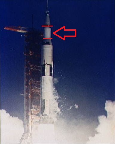
The launch of Apollo 12, with the 2nd stage arrowed. (Credit: NASA).
The launch of Apollo 12, with the 3rd stage (arrowed) would one day be “asteroid Joo2E3”. (Credit: NASA).

On September 3rd, 2002, amateur astronomer Bill Yeung discovered an asteroid tentatively designated J002E3. Subsequent studies revealed that the asteroid had a spectrum consistent with that of titanium oxide paint, a decidedly unasteroid-like coating for a space rock to sport. This was, however, a common veneer in use during the Apollo era, and it is now known that J002E3 is the S-IVB third stage booster that launched the second mission to land men on the Moon on November 14th, 1969. Unlike other boosters, such as the one that launched Apollo 14, the Apollo 12 3rd stage did not impact the Moon as part of seismic experiments. After a brief period as a “pseudo-moon” of the Earth, J002E3 was kicked out into solar orbit in June 2003 and may return to our neighborhood once again in the 2040s.     

NASA’s Lunar Reconnaissance Orbiter has documented the lunar crash sites of these historic boosters. It’s of note that the Apollo 10 Lunar Module Snoopy remains discarded out in solar orbit as well, having been used as a dress rehearsal for the historic Apollo 11 landing. Apollo 10 never landed on the Moon. Efforts have been made by UK astronomer Nick Howes to recover it as well.

And there are more relics of the Space Age awaiting discovery. One of the first things we always check in the case of a pass by a newly discovered NEO closer than the Moon to the Earth is its history, to see if it matches up with any launches headed out beyond Earth orbit in the past.

And the upcoming Mars launches of MAVEN and India’s Mars Orbiter Mission in October & November will be the first to depart Earth orbit since 2011. These will give future generations of asteroid hunters new human-made space hardware to ponder.

The B612 Foundation’s asteroid-hunting Sentinel Space Telescope will also “up the game,” scouting for asteroids from a vantage point interior to the Earth’s orbit. Sentinel is slated for launch in 2016 atop a SpaceX Falcon 9 rocket.

And no, the fabled “Black Knight” satellite of UFO conspiracy buffs’ dreams is nowhere to be found.

What other fascinating relics of the Space Age lie are out there in the solar system, waiting to tell their tale?

How to Spot Commercial Cygnus Craft Chasing ISS for Sept. 22 Coupling

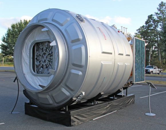
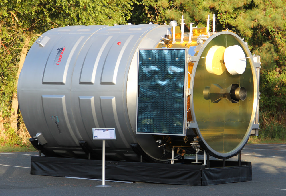
After launching to orbit atop the Antares rocket on Sept. 18, the first ever Cygnus cargo spacecraft is chasing the ISS and set to dock on Sept 22. Until then you may be able to track it in the night skies. Here is full scale, high fidelity mockup of Cygnus to give a feel for its size being similar to a small room. Credit: Ken Kremer (kenkremer.com)

After launching to orbit atop the Antares rocket on Sept. 18, the first ever Cygnus cargo spacecraft is chasing the ISS and set to dock on Sept 22. Until then you have the opportunity to track it in the night skies. This full scale, high fidelity mockup of the Orbital Sciences/Thales Alenia Cygnus gives a feel for it being similar in size to a small room. Credit: Ken Kremer (kenkremer.com)
Story Updated: Further details and photos – and NASA TV link to Live Docking Coverage [/caption]

WALLOPS ISLAND, VA – Following Wednesday morning’s (Sept. 18) spectacular blastoff of the Antares rocket with the commercial Cygnus resupply spacecraft, sky watchers now have a very limited window of opportunity to spot the maiden Cygnus chasing down the International Space Station (ISS) in the early morning skies before it arrives for the historic 1st rendezvous and docking on Sunday morning, Sept 22.

So between now and early Sunday you have the chance to gaze skywards and see and photograph history’s first Earth orbiting Cygnus hunting the ISS and gradually close in for the delicate coupling maneuver.

Here’s our guide on ‘How to Spot Cygnus’.

Sighting opportunities are available worldwide from at least North and South America, Europe, Asia and Africa according to NASA’s ‘Spot the Station’ website – here. See more websites listed below.

Update 4 a.m. Sunday Sept 22– Cygnus Rendezvous Delayed 48 Hours due to communications glitch
Update Sept 23: delayed to no earlier than Saturday due to Soyuz launch on Wednesday. Thus more chances to view!

Time is of the essence! So don’t delay to check this out!

Since the successful separation of the first Cygnus – built by Orbital Sciences and Thales Alenia – from Antares, the Earth orbiting vehicle has been successfully firing its hydrazine fueled thrusters to move ever closer to the massive orbiting lab complex – at a rate of 82 statute miles per orbit..

Artist rendering of Cygnus spacecraft approaching the International Space Station

If all of the ten on orbit maneuvering tests proceed satisfactorily, Cygnus will reach the vicinity of the station on Sunday early morning (US East Coast time).

“There are some ‘goodies’ stowed on board for the crew’s enjoyment,” Alan Lindenmoyer, NASA’s program manager for commercial crew and cargo, told Universe Today at NASA Wallops.

ISS astronauts Karen Nyberg (NASA) and Luca Parmitano (ESA) are scheduled to grapple Cygnus with the station’s Canadian built robotic arm between 7:15 and 7:30 a.m. EDT, if all goes well.

Nyberg and Parmitano, working at a robotic work station in the Cupola module, are due to install the cargo carrier at an earth facing docking port on the Harmony pressurized module as early as 9 a.m. EDT, Sept 22.

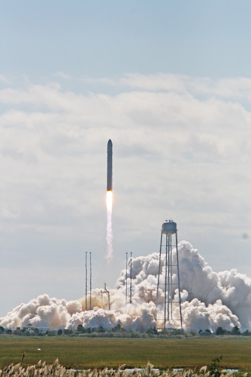
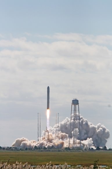
Antares rocket lifts off at 10:58 a.m. EDT Sept 18 with commercial Cygnus cargo resupply ship bound for the International Space Station (ISS) from Mid-Atlantic Regional Spaceport Pad-0A at NASA’s Wallops Flight Facility in Virginia.  Credit: Ken Kremer (kenkremer.com)
Antares rocket lifts off at 10:58 a.m. EDT Sept 18 with commercial Cygnus cargo resupply ship bound for the International Space Station (ISS) from Mid-Atlantic Regional Spaceport Pad-0A at NASA’s Wallops Flight Facility in Virginia. Credit: Ken Kremer (kenkremer.com)

It’s the same docking port already used by the SpaceX Dragon cargo vessel on three successful missions to date since 2012.

Cameras on the second stage captured this amazing image of the Cygnus spacecraft separating from the rocket into orbit.
Although Cygnus is much smaller than the ISS, it should still be visible – weather permitting of course.

At 17 feet (5 meters) long and 10 feet (3 meters) wide, Cygnus is the size of a small room.

In fact, while I was at NASA Wallops this week reporting on the Antares launch for Universe Today, I had a chance to visit a full scale, high fidelity mockup of Cygnus built for Orbital Sciences and on display at the local community center in Chincoteague, VA.

The Cygnus display model gives one a great feel for just how big Cygnus really is- see my photos herein.

Front view showing docking mechanism and hatch of Cygnus module in this full scale, high fidelity mockup of the Orbital Sciences/Thales Alenia spacecraft gives a feel for it being similar in size to a small room.  Credit: Ken Kremer (kenkremer.com)
Front view showing docking mechanism and hatch of Cygnus module in this full scale, high fidelity mockup of the Orbital Sciences/Thales Alenia spacecraft gives a feel for it being similar in size to a small room. Credit: Ken Kremer (kenkremer.com)

A full size human mannequin standing inside showed that a human can fit comfortably inside.

Thales Alenia Space in Italy designed and constructed the 17 foot ( 5 meter) long Cygnus pressurized module under contract with Orbital.

“Thales Alenia has actually built 50% of the pressurized modules currently comprising the ISS,” said Luigi Quaglino, Thales Alenia Senior Vice President.

“We have built 25 pressurized space modules and learned a lot along the way,” Quaglino told Universe Today at NASA Wallops.

The ISS is the largest manmade object in orbit. It’s the size of a football field and the brightest object in the night sky after the Moon thanks also to the huge, reflecting solar arrays.

Cygnus will be significantly dimmer, but nevertheless should be readily visible.

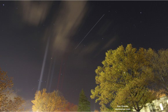
Look for a ‘star’ moving gradually against the backdrop of stars trailing behind the ISS that likewise appears as a bright moving ‘star’.

ISS streaks over Princeton, NJ - time lapse image.  Credit: Ken Kremer
ISS streaks over Princeton, NJ – time lapse image. Credit: Ken Kremer

As Sunday approaches, the gap between the ISS and Cygnus narrows.

On Thursday Cygnus was trailing about 10 minutes behind the ISS. Whereas on Friday and Saturday, the gap narrows down to roughly 4 minutes and then just 1 minute.

You can also try and photograph the ISS and Cygnus trails by mounting your camera on a tripod and leaving the shutter open at least several seconds and longer. Send me any cool time lapse photos to post here at Universe Today.

Many folks have never seen an ISS flyover and this is a fantastic time to start as the dynamic duo speed merrily across the nighttime sky.

To determine if there are any favorable sighting opportunities in your area, check out NASA’s Spot the Station website – here.

Check the NASA website for a detailed listing of the precise times, elevations, direction and durations. It’s an easy to use viewing guide. Just plug in the particulars of the country in which you live.

Another great source is Heaven’s Above – here

Also check Spaceweather.com – here

And Orbital Sciences reports that “AGI has developed a slick interactive 2D/3D simulation that allows you to track the location of Cygnus in real-time.”

Details here and here

I have personally watched the SpaceX Dragon, European ATV and Japanese HTV cargo carriers streaking through the night sky, trailing a few minutes behind the ISS. And it’s always a thrill.

The cargo vessel will deliver about 1,300 pounds (589 kilograms) of cargo, including food, clothing, water, science experiments, spare parts and gear to the Expedition 37 crew.

Cygnus will remain attached to the ISS for about a month. The astronauts will unload the supplies including few goodies starting on Monday. They they’ll pack it with trash. After undocking Cygnus will come to a flaming finale by burning up upon reentry into the Earth’s atmosphere.

So there should be a final opportunity to view it circling Earth.

NASA Television coverage of the arrival and capture of Cygnus will begin at 4:30 a.m. EDT

Streaming video will be available on NASA’s website at http://www.nasa.gov/ntv

Saturday evening Update:

NASA has given the GO for Sunday morning Docking !

Happy Viewing and Clear Skies

Ken Kremer

…………….

Learn more about Cygnus, Antares, LADEE, Curiosity, Mars rovers, MAVEN, Orion and more at Ken’s upcoming presentations

Oct 3: “Curiosity, MAVEN and the Search for Life on Mars – (3-D)”, STAR Astronomy Club, Brookdale Community College & Monmouth Museum, Lincroft, NJ, 8 PM

Oct 8: NASA’s Historic LADEE Lunar & Antares/Cygnus ISS Rocket Launches from Virginia”; Princeton University, Amateur Astronomers Assoc of Princeton (AAAP), Princeton, NJ, 8 PM
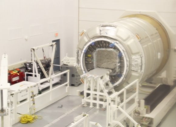
1st operational Cygnus pressurized cargo module from Orbital Sciences Corp. & Thales Alenia Space sits inside high bay clean room facility at NASA Wallops Flight Facility, VA for preflight processing. This Cygnus spacecraft arrived from Italy and may launch to the ISS as early as December 2013 from Wallops launch pad 0A. Credit: Ken Kremer (kenkremer.com)
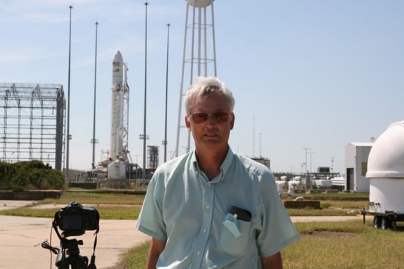
Ken Kremer (Universe Today)and Antares rocket at NASAWallops Launch Complex 0A. Credit: Ken Kremer
Ken Kremer (Universe Today) and Antares rocket at NASA Wallops Launch Complex 0A. Credit: Ken Kremer

An Unexpected Ending for Deep Impact

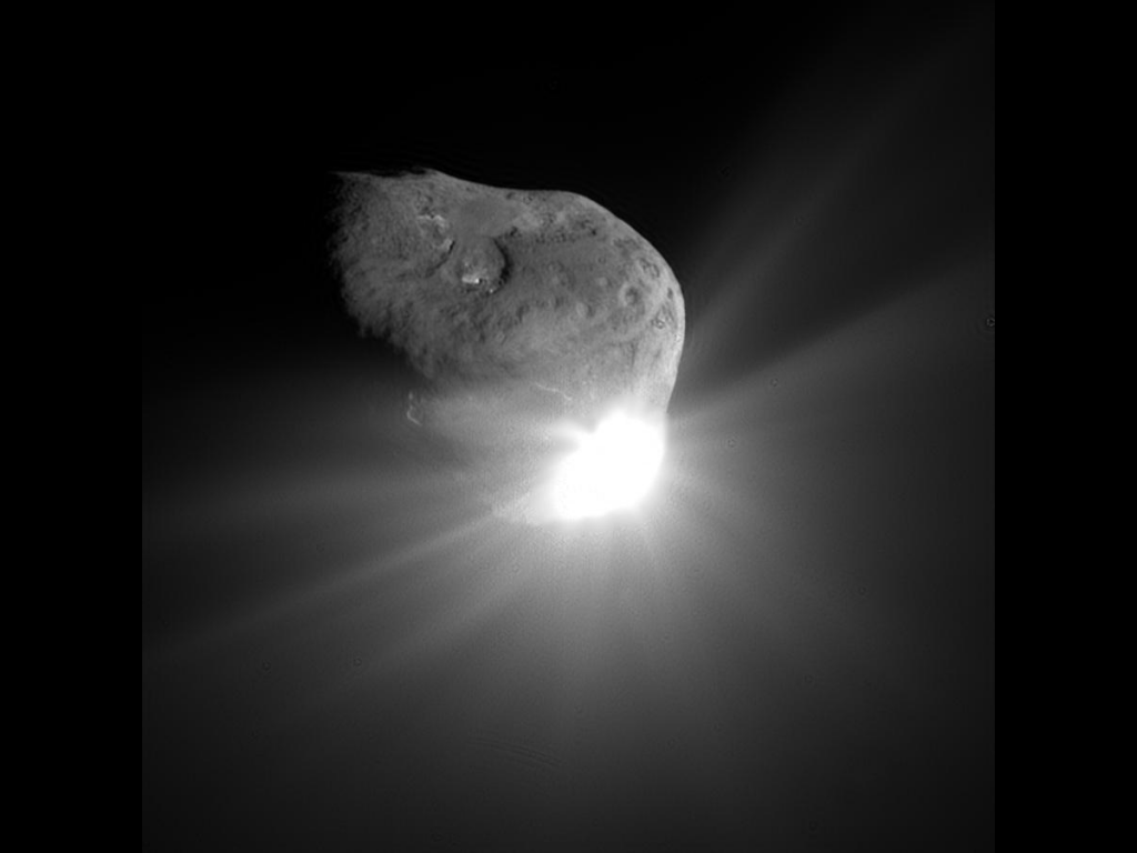
Comet Tempel 1 a minute after being struck by Deep Impact's impactor on July 4, 2005 (NASA/JPL-Caltech/UMD)

After almost 9 years in space that included an unprecedented July 4th impact and subsequent flyby of a comet, an additional comet flyby, and the return of approximately 500,000 images of celestial objects, NASA’s Deep Impact/EPOXI mission has officially been brought to a close.

The project team at NASA’s Jet Propulsion Laboratory has reluctantly pronounced the mission at an end after being unable to communicate with the spacecraft for over a month. The last communication with the probe was Aug. 8. Deep Impact was history’s most traveled comet research mission, having journeyed a total of about 4.7 billion miles (7.58 billion kilometers).

“Deep Impact has been a fantastic, long-lasting spacecraft that has produced far more data than we had planned,” said Mike A’Hearn, the Deep Impact principal investigator at the University of Maryland in College Park. “It has revolutionized our understanding of comets and their activity.”

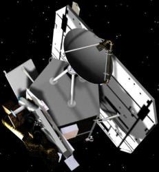
Artist's rendering of the Deep Impactor flyby spacecraft (NASA)
Artist’s rendering of the Deep Impactor flyby spacecraft (NASA)

Launched in January 2005, the spacecraft first traveled about 268 million miles (431 million kilometers) to the vicinity of comet Tempel 1. On July 3, 2005, the spacecraft deployed an impactor into the path of comet to essentially be run over by its nucleus on July 4. This caused material from below the comet’s surface to be blasted out into space where it could be examined by the telescopes and instrumentation of the flyby spacecraft.  Sixteen days after that comet encounter, the Deep Impact team placed the spacecraft on a trajectory to fly back past Earth in late December 2007 to put it on course to encounter another comet, Hartley 2 in November 2010, thus beginning the spacecraft’s new EPOXI mission.

“Six months after launch, this spacecraft had already completed its planned mission to study comet Tempel 1,” said Tim Larson, project manager of Deep Impact at JPL. “But the science team kept finding interesting things to do, and through the ingenuity of our mission team and navigators and support of NASA’s Discovery Program, this spacecraft kept it up for more than eight years, producing amazing results all along the way.”

The spacecraft’s extended mission culminated in the successful flyby of comet Hartley 2 on Nov. 4, 2010. Along the way, it also observed six different stars to confirm the motion of planets orbiting them, and took images and data of the Earth, the Moon and Mars. These data helped to confirm the existence of water on the Moon, and attempted to confirm the methane signature in the atmosphere of Mars.  One sequence of images is a breathtaking view of the Moon transiting across the face of Earth.

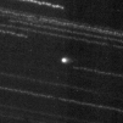
This image of comet ISON C/2012 S1 from NASA’s Deep Impact/EPOXI  spacecraft clearly shows the coma and nucleus on Jan. 17 and 18, 2013 beyond the orbit of Jupiter. Credit: NASA.
This image of comet ISON C/2012 S1 from NASA’s Deep Impact/EPOXI spacecraft clearly shows the coma and nucleus on Jan. 17 and 18, 2013 beyond the orbit of Jupiter. Credit: NASA.

The spacecraft’s extended mission culminated in the successful flyby of comet Hartley 2 on Nov. 4, 2010. In January 2012, Deep Impact performed imaging and accessed the composition of distant comet C/2009 P1 (Garradd).

It took images of comet ISON this year and collected early images of comet ISON in June.

After losing contact with the spacecraft last month, mission controllers spent several weeks trying to uplink commands to reactivate its onboard systems. Although the exact cause of the loss is not known, analysis has uncovered a potential problem with computer time tagging that could have led to loss of control for Deep Impact’s orientation. That would then affect the positioning of its radio antennas, making communication difficult, as well as its solar arrays, which would in turn prevent the spacecraft from getting power and allow cold temperatures to ruin onboard equipment, essentially freezing its battery and propulsion systems.

Without battery power, the Deep Impact spacecraft is now adrift and silent, spinning out of control through the solar system.

Launch of Deep Impact aboard a Boeing Delta II from Cape Canaveral AFB on Jan. 12, 2005 (NASA)
Launch of Deep Impact aboard a Boeing Delta II rocket from Cape Canaveral AFS on Jan. 12, 2005 (NASA)

“Despite this unexpected final curtain call, Deep Impact already achieved much more than ever was envisioned. Deep Impact has completely overturned what we thought we knew about comets and also provided a treasure trove of additional planetary science that will be the source data of research for years to come.”

– Lindley Johnson, Program Executive for the Deep Impact mission

It’s a sad end for a hardworking spacecraft, but over the course of its 8 1/2 years in space Deep Impact provided many significant results for the science community. Here are the top five, according to the mission’s principal investigator Michael A’Hearn.

Read more about the Deep Impact mission here.

Source: NASA press release

Antares Picture Perfect Blastoff Launches Commercial Space Race

Antares rocket lifts off at 10:58 a.m. EDT Sept 18 with commercial Cygnus cargo resupply ship bound for the International Space Station (ISS) from Mid-Atlantic Regional Spaceport Pad-0A at NASA’s Wallops Flight Facility in Virginia. Credit: Ken Kremer (kenkremer.com)

Antares rocket lifts off at 10:58 a.m. EDT Sept 18 with commercial Cygnus cargo resupply ship bound for the International Space Station (ISS) from Mid-Atlantic Regional Spaceport Pad-0A at NASA’s Wallops Flight Facility in Virginia. Credit: Ken Kremer (kenkremer.com)
Story updated[/caption]

WALLOPS ISLAND, VA – The new ‘Commercial Space Era’ received a resounding boost today when a privately developed Antares rocket lofting the first ever Cygnus commercial cargo resupply craft thundered to space from America’s newest launch pad at NASA Wallops along the Eastern Shore of Virginia.

The history making launch marks the first time that a spacecraft launched from Virginia is blazing a path to the International Space Station (ISS) – thereby scoring a milestone achievement to keep the orbiting lab complex stocked up with supplies and science experiments from American soil. This is the maiden flight of Cygnus.

Move over SpaceX ! Your space competition from Orbital Sciences has arrived!

It was a ‘picture perfect’ blastoff for the two stage Antares booster at 10:58 a.m. EDT this morning (Sept. 18) from the commercial Mid-Atlantic Regional Spaceport Pad-0A at NASA’s Wallops Flight Facility in Virginia.

The blastoff of Antares was stunningly beautiful with intensely bright flames spewing from the rockets rear. And the incredibly loud roar of the first stage engines reverberated widely and wowed hoards of spectators gathered throughout the local viewing area in Chincoteague, Va. – and woke late sleepers some folks told me later today!

The rumbling thunder of Antares sounded as loud as a space shuttle.

Launch of the Antares rocket at 10:58 a.m. EDT Sept 18 with Cygnus cargo resupply ship bound for the ISS NASA Wallops, VA.  Credit: Ken Kremer (kenkremer.com)
Launch of the Antares rocket at 10:58 a.m. EDT Sept 18 with Cygnus cargo resupply ship bound for the ISS NASA Wallops, VA. LADEE Moon shot launch pad at right. Credit: Ken Kremer (kenkremer.com)

Antares and Cygnus were built by Orbital Sciences Corporation and its team of industrial partners using seed money from NASA’s COTS commercial transportation initiative aimed at fostering the development of America’s commercial space industry to deliver critical and essential supplies to the ISS.

America lost 100% of its capability to send humans and cargo to the ISS when NASA’s space shuttles were retired in 2011. Orbital Sciences and their competitor SpaceX, were awarded NASA contracts to restore the unmanned cargo resupply capability.

Thales Alenia Space in Italy designed and constructed the 17 foot ( 5 meter) long Cygnus module under contract with Orbital.

“Thales Alenia has actually built 50% of the pressurized modules currently comprising the ISS,” said Luigi Quaglino, Thales Alenia Senior Vice President.

“This is a historic accomplishment for commercial spaceflight with the picture perfect launch of Antares and Cygnus headed for the space station,” said Alan Lindenmoyer, NASA’s program manager for commercial crew and cargo, at a post launch briefing for reporters at NASA Wallops.

In fact this was the heaviest cargo load ever delivered to the ISS by a commercial vehicle, said Frank Culbertson, former astronaut and now Orbital’s executive Vice President responsible for the Antares and Cygnus programs.

A revolutionary new day has dawned in space by opening up new pathways enabling space exploration And it’s not a moment too soon given the continuing significant reductions to NASA’s budget.

Antares rocket lifts off at 10:58 a.m. EDT Sept 18 with commercial Cygnus cargo resupply ship bound for the International Space Station (ISS) from Mid-Atlantic Regional Spaceport Pad-0A at NASA’s Wallops Flight Facility in Virginia.  Credit: Ken Kremer (kenkremer.com)
Antares rocket lifts off at 10:58 a.m. EDT Sept 18 with commercial Cygnus cargo resupply ship bound for the International Space Station (ISS) from Mid-Atlantic Regional Spaceport Pad-0A at NASA’s Wallops Flight Facility in Virginia. Credit: Ken Kremer (kenkremer.com)

COTS was aimed at revolutionizing how we reach space by privatizing routine space operations that thereby allows NASA to focus more on exploration beyond low earth orbit, getting people back to the Moon and beyond to deep space destinations including Asteroids and Mars.

Today’s Antares launch is the culmination of the COTS contract that NASA awarded to Orbital back in 2008.

Antares launch on Sept. 18 from NASA Wallops. Credit: NASA/Bill Ingalls

“Today marks a milestone in our new era of exploration as we expand the capability for making cargo launches to the International Space Station from American shores,” said NASA Administrator Charles Bolden in a statement.

“Orbital’s extraordinary efforts are helping us fulfill the promise of American innovation to maintain our nation’s leadership in space.”

The Cygnus spacecraft is healthy and successfully unfurled its life giving solar panels starting 1.5 minutes after separation from the second stage that took place about 10 minutes after launch, said Culbertson.

Antares placed Cygnus into its intended orbit of about 180 x 160 miles above the Earth, inclined at 51.6 degrees to the equator, Orbital said.

Antares launch on Sept. 18 from NASA Wallops. Credit: NASA/Bill Ingalls

Cygnus is traveling at 17,500 MPH and is on its way to rendezvous with the space station Sunday, Sept. 22. The cargo vessel will deliver about 1,300 pounds (589 kilograms) of cargo, including food, clothing, water, science experiments, spare parts and gear to the Expedition 37 crew.

The flight, known as Orb-D1 is a demonstration mission to prove that Cygnus can conduct a complex series of maneuvers in space safely bringing it to the vicinity of the ISS.

Mission controllers at Orbital will guide Cygnus to the vicinity of the ISS on Sept. 22.

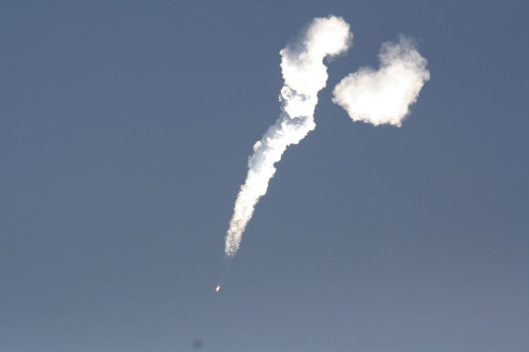
Antares and Cygnus soar to space on a plume of smoke and ash from NASA Wallops on Sept. 18, 2013 at 10:50 a.m. EDT.  Credit: Ken Kremer (kenkremer.com)
Antares and Cygnus soar to space on a plume of smoke and ash from NASA Wallops on Sept. 18, 2013 at 10:50 a.m. EDT. Credit: Ken Kremer (kenkremer.com)

But its only after carrying out a series of 10 complicated maneuvering tests proving that the vehicle can safely and reliably approach the station up close that NASA and the ISS partners will grant permission to dock.

ISS astronauts Karen Nyberg (NASA) and Luca Parmitano (ESA) will then grapple Cygnus with the station’s Canadian built robotic arm and berth the capsule at an earth facing docking port on Sunday, Sept 22. will then grapple Cygnus with the station’s robotic arm and berth the capsule at an earth facing docking port.

NASA and Orbital Sciences officials brief reporters at the Antares post launch press conference on Sept 18; Robert Lightfoot, NASA Associate Administrator, Alan Lindenmoyer, NASA’s program manager for commercial crew and cargo, Frank Culbertson, Orbital Sciences Executive VP. Credit: Ken Kremer (kenkremer.com)
NASA and Orbital Sciences officials brief reporters at the Antares post launch press conference on Sept 18; Robert Lightfoot, NASA Associate Admisistrator, Alan Lindenmoyer, NASA’s program manager for commercial crew and cargo, Frank Culbertson, Orbital Sciences Executive VP. Credit: Ken Kremer (kenkremer.com)

The Antares first stage is powered by dual liquid fueled AJ26 first stage rocket engines that generate a combined total thrust of some 750,000 lbs – originally built in the Soviet Union as NK-33 model engines for the Soviet era moon rocket.

The upper stage features an ATK Castor 30 solid rocket motor with thrust vectoring. Antares can loft payloads weighing over 5000 kg to LEO. The 2nd stage will be upgraded starting with the 4th Antares flight.

“Antares next flight is scheduled for December sometime between the 8th and 21st”, said Culbertson.

Ken Kremer
…………….

Learn more about Cygnus, Antares, LADEE, Curiosity, Mars rovers, MAVEN, Orion and more at Ken’s upcoming presentations

Sep 17/18: LADEE Lunar & Antares/Cygnus ISS Rocket Launches from Virginia”; Rodeway Inn, Chincoteague, VA

Oct 3: “Curiosity, MAVEN and the Search for Life on Mars – (3-D)”, STAR Astronomy Club, Brookdale Community College & Monmouth Museum, Lincroft, NJ, 8 PM

Oct 8: LADEE Lunar & Antares/Cygnus ISS Rocket Launches from Virginia”; Princeton University, Amateur Astronomers Assoc of Princeton (AAAP), Princeton, NJ, 8 PM
1st operational Cygnus pressurized cargo module from Orbital Sciences Corp. & Thales Alenia Space sits inside high bay clean room facility at NASA Wallops Flight Facility, VA for preflight processing. This Cygnus spacecraft arrived from Italy and may launch to the ISS as early as December 2013 from Wallops launch pad 0A. Credit: Ken Kremer (kenkremer.com)
Alan Lindenmoyer, NASA’s program manager for commercial crew and cargo  at pre-launch rollout of Antares rocket to pad 0A at NASA Wallops.  Credit: Ken Kremer (kenkremer.com)
Alan Lindenmoyer, NASA’s program manager for commercial crew and cargo at pre-launch rollout of Antares rocket to pad 0A at NASA Wallops. Credit: Ken Kremer (kenkremer.com)

Proof! – Frogs Jump at Chance to Board Rockets to Space from NASA Wallops during Antares booster Rollout

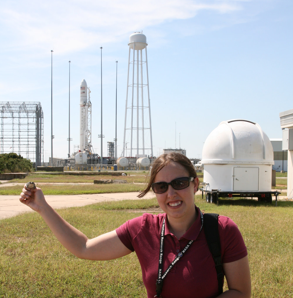
NASA Photographer discovers living proof that Frogs are leaping towards the on ramp for rocket ships bound for Earth orbit and beyond at NASA’s Wallops Island, VA, launch pads during rollout of the Antares rocket on Sept 13, 2013. Credit: Ken Kremer (kenkremer.com)

WALLOPS ISLAND, VA – Have you seen the NASA frog? The one that became famous worldwide last week following the historic Moon Shot of the LADEE mission from NASA Wallops Island in Virginia?

The one that the inexplicably appeared in a single photograph from a NASA Wallops remote camera when the pressure wave from the Minotaur rockets exhaust sent it hurtling skywards?

Perhaps you are an unbeliever? And think the frog photo was photoshopped?

Well after a thorough investigation, Universe Today has uncovered undeniable proof that NASA’s resident frogs are indeed jumping at the chance to make history again and leap aboard the next rocket headed to space from NASA Wallops on Sept 18.

How do I know this?

Well on Friday the 13th of September, I was on site at NASA Wallops for a photo shoot of the lengthy rollout of the Orbital Sciences Antares rocket to Launch Pad 0A – and the famous frog was a topic of endless conversation in between our gorgeous views of Antares moving along the road to the launch pad atop the Transporter Erector vehicle.

See my frog and rollout photo gallery herein.

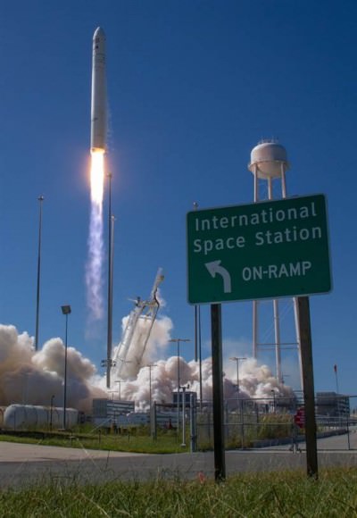
Antares rocket arrives at on ramp to launch pad with cool new signs directing traffic to launch pads for trips to the Moon and the International Space Station. Credit: Ken Kremer (kenkremer.com)

Nary a frog was to be found anywhere all day and night along the 1 mile rollout route.

Finally, after much delay the Antares rocket was raised and erected firmly atop the launch mount.

And then at last the great frog discovery was made.

Close up of frog hiding near the Antares launch pad and apparently eager to jump aboard.    Credit: Ken Kremer (kenkremer.com)
Close up of frog hiding near the Antares launch pad and apparently eager to jump aboard. Credit: Ken Kremer (kenkremer.com)

And of course it took a woman, a NASA photographer named Jamie, to do a man’s job – finding and corralling that frog and fearlessly holding the critter in front of all the guys, including me.

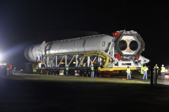
Antares rocket begins rollout atop transporter erector to Launch Pad 0A at NASA Wallops Island Facility, VA., on Sept. 13, 2013.  Credit: Ken Kremer (kenkremer.com)
Antares rocket begins rollout atop transporter erector to Launch Pad 0A at NASA Wallops Island Facility, VA., on Sept. 13, 2013. Credit: Ken Kremer (kenkremer.com)

My photos are the proof that the mysterious origin of NASA’s apparently space loving resident frogs has been solved.

Jamie discovered the frog lurking inside a telescope dome used to protect NASA’s launch pad cameras during liftoff.

Antares rocket begins rollout atop transporter erector to Launch Pad 0A at NASA Wallops Island Facility, VA., on Sept. 13, 2013.  Credit: Ken Kremer (kenkremer.com)
Antares rocket begins rollout atop transporter erector to Launch Pad 0A at NASA Wallops Island Facility, VA., on Sept. 13, 2013. Credit: Ken Kremer (kenkremer.com)

She found the frog hiding inside the dome to evade the ever present security patrols on the lookout for intruders. Where is the NSA when you need them?

And quite clearly these are intelligent frogs – eager to blast off to the High Frontier in pursuit of science.

Why?

Because for the past few weeks these space loving frogs have been reading the new pair of signs installed by the launch pad gates right in front of the on ramps directing traffic to the Minotaur and Antares rockets headed to the Moon and the International Space Station.

They were just waiting for the right moment to hop aboard.

Antares rocket rolls up on on ramp at NASA Wallops launch pad 0A bound for the ISS on Sept 18, 2013. Credit: Ken Kremer (kenkremer.com)

Everything remains on target for the Sept. 18 blastoff of Orbital Sciences Antares commercial rocket carrying the first fully functional Cygnus commercial resupply vehicle to orbit from NASA’s Wallops Island Facility on a demonstration mission bound for the International Space Station (ISS).

“The weather forecast remains at 75% chance of “GO” with favorable conditions,” said NASA Wallops test director Sarah Daugherty at a news media briefing at Wallops today.

“The launch could be widely visible along the East Coast from New York City to South Carolina.” – Weather permitting

Antares rocket raised at NASA Wallops launch pad 0A bound for the ISS on Sept 18, 2013. Credit: Ken Kremer (kenkremer.com)

Learn how and where to view the Antares launch by reading my “How to see the Antares Launch” story.

NASA Television coverage of the Antares launch will begin at 10:15 a.m. on Sept 18 – (www.nasa.gov/ntv).

Antares rocket raised at NASA Wallops launch pad 0A bound for the ISS on Sept 18, 2013. Credit: Ken Kremer (kenkremer.com)

Stay tuned to Universe Today for complete coverage of the Antares/Cygnus Orb-D1 mission to the ISS and my continuing Antares and LADEE mission reports from on site at NASA’s Wallops Launch Pads in sunny Virginia – reporting for Universe Today.

Ken Kremer

Antares rocket raised at NASA Wallops launch pad 0A bound for the ISS on Sept 18, 2013. Credit: Ken Kremer (kenkremer.com)

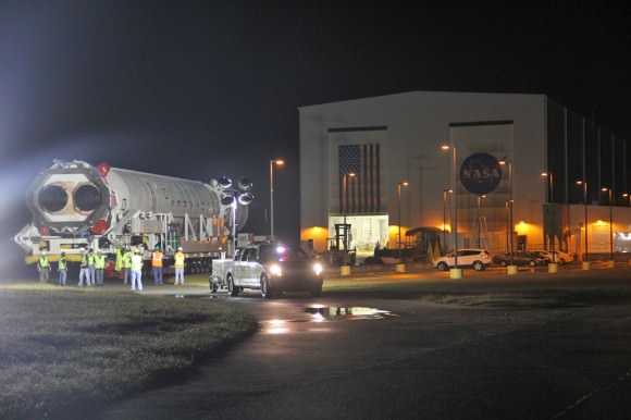
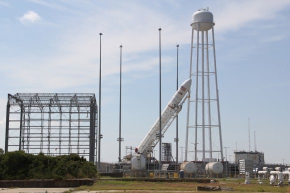
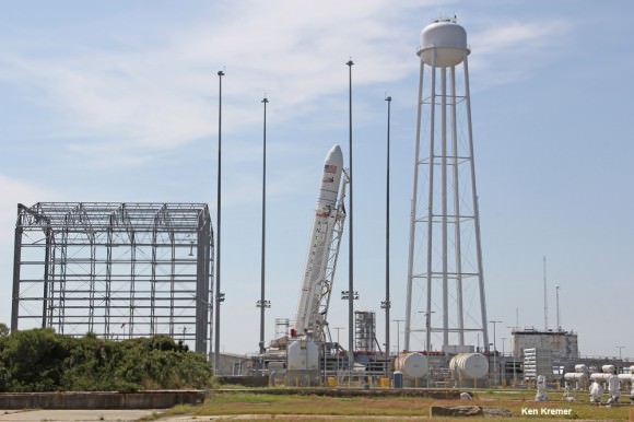
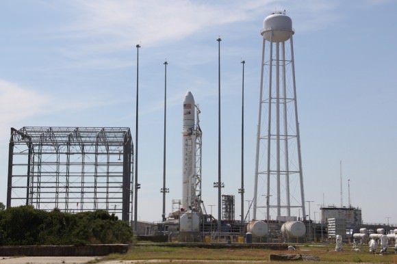
Antares rocket and Cygnus spacecraft after rollout to Launch Pad 0A at NASA Wallops Flight Facility Facility, VA.,on Sept. 13, 2013. Blastoff is slated for Sept. 18, 2013 at 10:50 a.m. EDT.  LADEE launch pad 0B stands adjacent to right of Antares.  Credit: Ken Kremer (kenkremer.com)
Antares rocket and Cygnus spacecraft after rollout to Launch Pad 0A at NASA Wallops Flight Facility Facility, VA.,on Sept. 13, 2013. Blastoff is slated for Sept. 18, 2013 at 10:50 a.m. EDT. LADEE launch pad 0B stands adjacent to right of Antares. Credit: Ken Kremer (kenkremer.com)

…………….

Learn more about Cygnus, Antares, LADEE, Curiosity, Mars rovers, MAVEN, Orion and more at Ken’s upcoming presentations

Sep 17/18: LADEE Lunar & Antares/Cygnus ISS Rocket Launches from Virginia”; Rodeway Inn, Chincoteague, VA

Oct 3: “Curiosity, MAVEN and the Search for Life on Mars – (3-D)”, STAR Astronomy Club, Brookdale Community College & Monmouth Museum, Lincroft, NJ, 8 PM

Oct 8: LADEE Lunar & Antares/Cygnus ISS Rocket Launches from Virginia”; Princeton University, Amateur Astronomers Assoc of Princeton (AAAP), Princeton, NJ, 8 PM
Seaside panoramic view of Antares rocket and Cygnus spacecraft after rollout to Launch Pad 0A at NASA Wallops at the Virginia Eastern Shore  on Sept. 13, 2013. Blastoff for the ISS is slated for Sept. 18, 2013 at 10:50 a.m. EDT Credit: Ken Kremer (kenkremer.com)
Seaside panoramic view of Antares rocket and Cygnus spacecraft after rollout to Launch Pad 0A at NASA Wallops at the Virginia Eastern Shore on Sept. 13, 2013. Blastoff for the ISS is slated for Sept. 18, 2013 at 10:50 a.m. EDT Credit: Ken Kremer (kenkremer.com)

A “Mini Jet” Juts from Saturn’s F Ring

A bright "mini-jet" spotted in Saturn's F ring

We all know that Saturn’s moon Enceladus has a whole arsenal of geysers jetting a constant spray of ice out into orbit (and if you didn’t know, learn about it here) but Enceladus isn’t the only place in the Saturnian system where jets can be found — there are some miniature versions hiding out in the thin F ring as well!

Watch the 50-mile-wide Prometheus dip into the F ring (CLICK TO PLAY) NASA/JPL/SSI. Animation by J. Major.

The image above, captured by the Cassini spacecraft on June 20, 2013, shows a segment of the thin, ropy F ring that encircles Saturn just beyond the A ring (visible at upper right). The bright barb near the center is what scientists call a mini jet, thought to be caused by small objects getting dragged through the ring material as a result of repeated passings by the shepherd moon Prometheus.

Coincidentally, it’s gravitational perturbations by Prometheus that help form the objects — half-mile-wide snowball-like clusters of icy ring particles — in the first place.

Unlike the dramatic jets on Enceladus, which are powered by tidal stresses that flex the moon’s crust, these mini jets are much more subtle and occur at the casual rate of 4 mph (2 meters/second)… about the speed of a brisk walk.

The reflective jets themselves can be anywhere from 25 to 112 miles (40 to 180 kilometers) long.

See more images of mini jets — also called “classic trails” — below:

Various images of mini jets captured by Cassini from 2005 to 2008.

Over 500 of these features have been imaged by Cassini since 2005. Read more about mini jets here.

(And don’t worry, Enceladus… these little jets are interesting but they have nothing on you!)

Source: Cassini Imaging Central Laboratory for OPerationS (CICLOPS)

Image credits: NASA/JPL-Caltech/SSI/QMUL. 

How to See the Historic Antares/Cygnus Launch to Space Station on Sept. 18

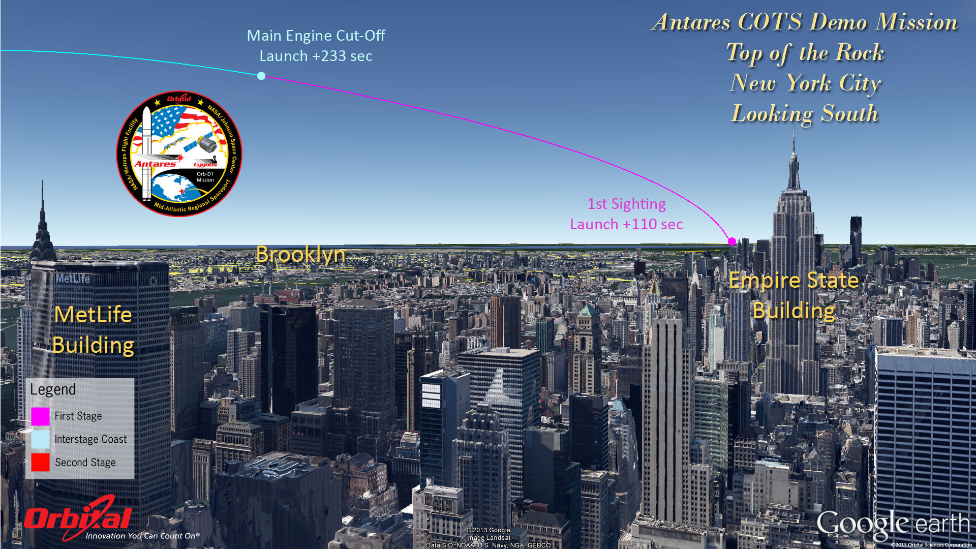
Top of the Rock - New York City. Antares rocket and Cygnus cargo spacecraft approximate launch trajectory view as should be seen from atop Rockefeller Center, NYC, on Sept. 18, 2013 at 10:50 a.m. EDT - weather permitting - after blastoff from NASA Wallops, VA. Credit: Orbital Sciences See more Antares launch trajectory viewing graphics below

Top of the Rock – New York City
Antares rocket and Cygnus cargo spacecraft approximate launch trajectory view as should be seen from atop Rockefeller Center, NYC, on Sept. 18, 2013 at 10:50 a.m. EDT – weather permitting – after blastoff from NASA Wallops, VA. Credit: Orbital Sciences
See more Antares launch trajectory viewing graphics below[/caption]

WALLOPS ISLAND, VA – “All Systems Are GO” for the Sept. 18 launch of Orbital Sciences Antares commercial rocket carrying the first ever fully functional Cygnus commercial resupply vehicle to orbit on the history making first flight blasting off from NASA’s Wallops Island Facility– along the eastern shore of Virginia and bound for the International Space Station (ISS).

Here’s our guide on “How to See the Antares/Cygnus Launch” – complete with viewing maps and trajectory graphics from a variety of prime viewing locations courtesy of Orbital Sciences, the private company that developed both the Antares rocket and Cygnus spaceship aimed at keeping the ISS fully operational for science research.

And although the launch is slated for late morning it should still be visible to millions of spectators along a lengthy swath of the US East Coast from North Carolina to Connecticut – weather permitting – who may have never before witnessed such a mighty rocket launch.

The daylight liftoff of the powerful two stage Antares rocket is scheduled for Wednesday, Sept 18 at 10:50 a.m. EDT from Launch Pad 0A at the Mid-Atlantic Regional Spaceport at NASA Wallops Island, Virginia. The launch window extends 15 minutes to 11:05 a.m.

Up top is the view as anticipated from “The Top of the Rock” or Rockefeller Center in New York City. See below the extraordinary image of LADEE’s launch from “Top of the Rock” by Ben Cooper to compare the day and night time sighting delights.

In anticipation of liftoff, the Antares rocket was rolled out to Pad 0A on Friday morning Sept. 13 and I was on hand for the entire event – see my rollout photos here and upcoming.

Seaside panoramic view of Antares rocket and Cygnus spacecraft after rollout to Launch Pad 0A at NASA Wallops at the Virginia Eastern Shore  on Sept. 13, 2013. Blastoff for the ISS is slated for Sept. 18, 2013 at 10:50 a.m. EDT Credit: Ken Kremer (kenkremer.com)
Seaside panoramic view of Antares rocket and Cygnus spacecraft after rollout to Launch Pad 0A at NASA Wallops at the Virginia Eastern Shore on Sept. 13, 2013. Blastoff for the ISS is slated for Sept. 18, 2013 at 10:50 a.m. EDT. LADEE launch pad 0B stands adjacent to right of Antares.
Credit: Ken Kremer (kenkremer.com)

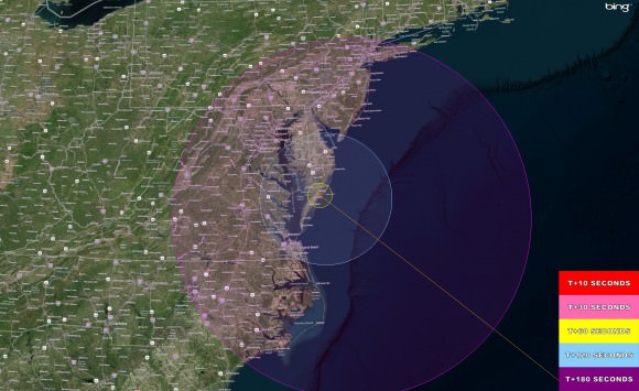
Here’s a hi res version of the viewing map courtesy of NASA Wallops Flight Facility:

Antares/Cygnus Launch - Hi Res Visibility map The Antares/Cygnus daylight rocket launch on Sept. 18, 2013 at 10:50 a.m. EDT from NASA Wallops, VA.  will potentially be visible to millions of spectators along the Eastern US coast from Connecticut to North Carolina -weather permitting. This high resolution map shows the regions of visibility over time in the seconds after the rocket launch on a demonstration cargo resupply mission to the International Space Station.  Credit: NASA Wallops Flight Facility
Antares/Cygnus Launch – Hi Res Visibility map
The Antares/Cygnus daylight rocket launch on Sept. 18, 2013 at 10:50 a.m. EDT from NASA Wallops, VA. will potentially be visible to millions of spectators along the Eastern US coast from Connecticut to North Carolina -weather permitting. This high resolution map shows the regions of visibility over time in the seconds after the rocket launch on a demonstration cargo resupply mission to the International Space Station. Credit: NASA Wallops Flight Facility

The Antares launch follows closely on the heels of the spectacularly bright Sept. 6 nighttime Moon shot blastoff of the Minotaur V rocket that successfully injected NASA’s LADEE lunar orbiter into its translunar trajectory.

And just as was the case with the Minotaur V and LADEE, you don’t have to be watching locally to join in and experience all the fun and excitement. As with any NASA launch, you can also follow along with up to the minute play by play by watching the NASA TV webcast online or on smartphones, iPods or laptops.

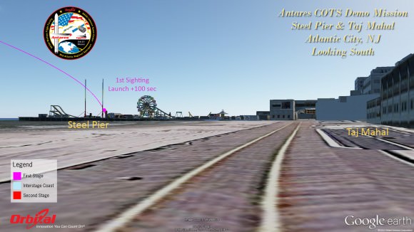
Atlantic City
Atlantic City

It’s hard to say exactly how long and how bright the rockets flames and exhaust trail will be visible since it depends on the constantly changing lighting, prevailing clouds and overall weather conditions.

But one thing is for sure. If you don’t go outside and watch you’re giving up a great opportunity.

And keep in mind that Antares will be moving significantly slower than the Minotaur V.

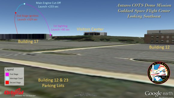
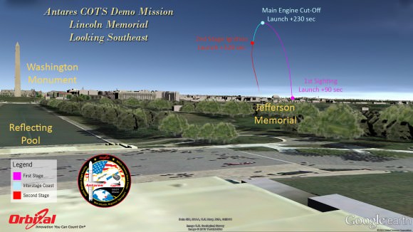
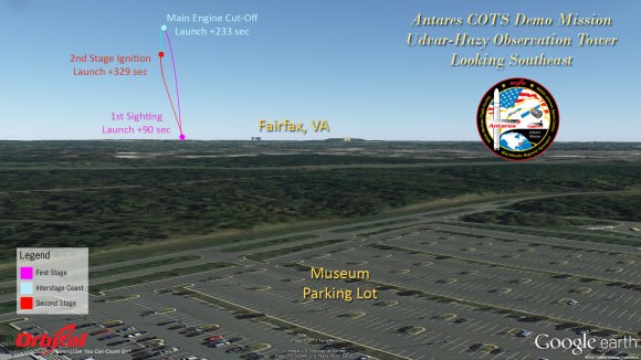
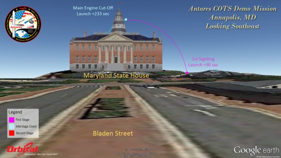
Herein are a series of graphics showing the Antares trajectory and what you should see during firings of both stages from the perspective of standing on the ground or skyscrapers at a variety of popular destinations including Annapolis, the US Capitol, Lincoln Memorial, National Air and Space Museum, Atlantic City, NJ, New York City and more.

Capitol East-Front Steps
Goddard Space Flight Center - GSFC
Goddard Space Flight Center – GSFC
Antares rocket and Cygnus spacecraft after rollout to Launch Pad 0A at NASA Wallops Flight Facility Facility, VA.,on Sept. 13, 2013. Blastoff is slated for Sept. 18, 2013 at 10:50 a.m. EDT.  LADEE launch pad 0B stands adjacent to right of Antares.  Credit: Ken Kremer (kenkremer.com)
Antares rocket and Cygnus spacecraft after rollout to Launch Pad 0A at NASA Wallops Flight Facility Facility, VA.,on Sept. 13, 2013. Blastoff is slated for Sept. 18, 2013 at 10:50 a.m. EDT. LADEE launch pad 0B stands adjacent to right of Antares. Credit: Ken Kremer (kenkremer.com)

The goal of the mission is to demonstrate the safe and successful launch, rendezvous and docking of the privately developed Cygnus cargo carrier with the International Space Station (ISS) and delivery of 1300 pounds of essential supplies, food, clothing, spare parts and science gear to the six person resident human crews – currently Expedition 37.

Although it’s the 2nd launch of Antares following the maiden flight in April, this is the first flight of the Cygnus commercial delivery system. The demonstration and testing will be the same as what SpaceX accomplished in 2012 with their competing Falcon 9/Dragon architecture.

The mission is designated Orb-D1 and is funded with seed money by NASA’s COTS program to replace the cargo delivery duties of NASA’s now retired Space Shuttle orbiters.

Lincoln Memorial
Lincoln Memorial
Richmond
Richmond

For those who are traveling to witness the launch locally in the Chincoteague, Va., area, there will be two public viewing sites said Jeremy Eggers, NASA Wallops Public Affairs Officer in an interview with Universe Today.

“There will be are two local sites open to the public,” Eggers told me. “Folks can watch at either the NASA Wallops Flight facility Visitors Center (http://sites.wff.nasa.gov/wvc) or the beach at Assateague National Seashore (http://www.nps.gov/asis/index.htm).”

“There will be loudspeakers to follow the progress of the countdown, but no TV screens as done with the LADEE launch.”

National Air & Space Udvar-Hazy Museum
Annapolis
Annapolis

So far the weather outlook is promising with a 75% chance of “GO” with favorable conditions at launch time.

NASA Television coverage of the Antares launch will begin at 10:15 a.m. on Sept 18 – (www.nasa.gov/ntv).

Be sure to watch for my continuing Antares and LADEE mission reports from on site at NASA’s Wallops Launch Pads in sunny Virginia – reporting for Universe Today.

Ken Kremer

…………….

Learn more about Cygnus, Antares, LADEE, Curiosity, Mars rovers, MAVEN, Orion and more at Ken’s upcoming presentations

Sep 17/18: LADEE Lunar & Antares/Cygnus ISS Rocket Launches from Virginia”; Rodeway Inn, Chincoteague, VA

Oct 3: “Curiosity, MAVEN and the Search for Life on Mars – (3-D)”, STAR Astronomy Club, Brookdale Community College & Monmouth Museum, Lincroft, NJ, 8 PM

Oct 8: LADEE Lunar & Antares/Cygnus ISS Rocket Launches from Virginia”; Princeton University, Amateur Astronomers Assoc of Princeton (AAAP), Princeton, NJ, 8 PM

This magnificent view of NASA’s LADEE lunar orbiter launched on Friday night Sept 6, on the maiden flight of the Minotaur V rocket from Virginia was captured by space photographer Ben Cooper perched atop Rockefeller Center in New York City. Credit: Ben Cooper/Launchphotography.com
This magnificent view of NASA’s LADEE lunar orbiter launched on Friday night Sept 6, on the maiden flight of the Minotaur V rocket from Virginia was captured by space photographer Ben Cooper perched atop Rockefeller Center in New York City. Compare this actual launch view to the graphic calculated for Antares (above) as seen from the exact same location atop Rockefeller Center. Credit: Ben Cooper/Launchphotography.com

The September Equinox: ‘Tis the Season to Spy the Zodiacal Light

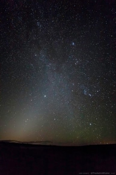
The zodiacal light in the Nevada dawn. The plane of the ecliptic can be traced by Jupiter in Gemini & Mars in the Beehive cluster just below center. (Credit: Cory Schmitz, used with permission).

This week leading up to the September equinox offers you a fine chance to catch an elusive phenomenon in the pre-dawn sky.

We’re talking about the zodiacal light, the ghostly pyramid-shaped luminescence that heralds the approach of dawn. Zodiacal light can also be seen in the post-dusk sky, extending from the western horizon along the ecliptic.

September is a great time for northern hemisphere observers to try and sight this glow in the early dawn. This is because the ecliptic is currently at a high and favorable angle, pitching the zodiacal band out of the atmospheric murk low to the horizon. For southern hemisphere observers, September provides the best time to hunt for the zodiacal light after dusk. In March, the situation is reversed, with dusk being the best for northern hemisphere observers and dawn providing the best opportunity to catch this elusive phenomenon for southern observers.

The clash of the zodiacal light and the plane of our galaxy. (Credit: Cory Schmitz, used with permission).

Cory Schmitz’s recent outstanding photos taken from the Nevada desert brought to mind just how ephemeral a glimpse of the zodiacal light can be. The glow was a frequent sight for us from dark sky sites just outside of Tucson, Arizona—but a rarity now that we reside on the light-polluted east coast of the U.S.

In order to see the zodiacal light, you’ll need to start watching before astronomical twilight—the start of which is defined as when the rising Sun reaches 18 degrees below the local horizon—and observe from as dark a site as possible under a moonless sky.

The Bortle dark sky scale lists the zodiacal light as glimpse-able under Class 4 suburban-to-rural transition skies. Under a Class 3 rural sky, the zodiacal light may extend up to 60 degrees above the horizon, and under truly dark—and these days, almost mythical—Class 1 and 2 skies, the true nature of the zodiacal band extending across the ecliptic can become apparent.  The appearance and extent of the zodiacal light makes a great gauge of the sky conditions at that favorite secret dark sky site.

The source of the zodiacal light is tiny dust particles about 10 to 300 micrometres in size scattered across the plane of the solar system. The source of the material has long been debated, with the usual suspects cited as micrometeoroid collisions and cometary dust. A 2010 paper by Peter Jenniskens and David Nesvorny in the Astrophysical Journal cites the fragmentation of Jupiter-class comets. Their model satisfactorily explains the source of about 85% of the material. Dust in the zodiacal cloud must be periodically replenished, as the material is slowly spiraling inward via what is known as the Poynting-Robertson effect. None other than Brian May of the rock group Queen wrote his PhD thesis on Radial Velocities in the Zodiacal Dust Cloud.

But even if you can’t see the zodiacal light, you still just might be able to catch it. Photographing the zodiacal light is similar to catching the band of the Milky Way. In fact, you can see the two crossing paths in Cory’s images, as the bright winter lanes of the Orion Spur are visible piercing the constellation of the same name. Cory used a 14mm lens at f/3.2 for the darker image with a 20 second exposure at ISO 6400 and a 24mm lens at f/2.8 with a 15 second exposure at ISO 3200 for the brighter shot.

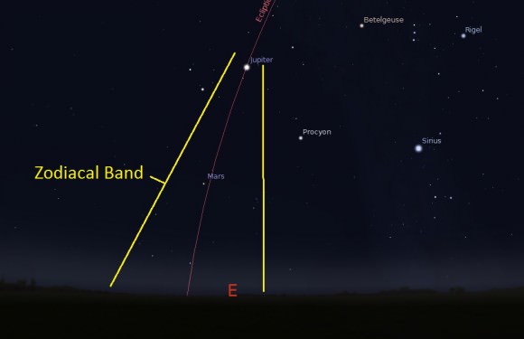
The orientation of the ecliptic & the zodiacal band as seen from latitude 30 deg north in September, about 1 hour before sunrise. (Created by the author in Stellarium).

Under a truly dark site, the zodiacal light can compete with the Milky Way in brightness. The early Arab astronomers referred to it as the false dawn. In recent times, we’ve heard tales of urbanites mistaking the Milky Way for the glow of a fire on the horizon during blackouts, and we wouldn’t be surprised if the zodiacal light could evoke the same. We’ve often heard our friends who’ve deployed to Afghanistan remark how truly dark the skies are there, as military bases must often operate with night vision goggles in total darkness to avoid drawing sniper fire.

Another even tougher but related phenomenon to spot is known as the gegenschein. This counter glow sits at the anti-sunward point where said particles are approaching 100% illumination. This time of year, this point lies off in the constellation Pisces, well away from the star-cluttered galactic plane. OK, we’ve never seen it, either. A quick search of the web reveals more blurry pics of guys in ape suits purporting to be Bigfoot than good pictures of the gegenschein. Spotting this elusive glow is the hallmark of truly dark skies. The anti-sunward point and the gegenschein rides highest near local midnight.

And speaking of which, the September equinox occurs this weekend on the 22nd at 4:44 PM EDT/20:44 Universal Time. This marks the beginning of Fall for the northern hemisphere and the start of summer for the southern.

The Full Harvest Moon also occurs later this week, being the closest Full Moon to the equinox occurring on September 19th at 7:13AM EDT/11:13 UT. Said Moon will rise only ~30 minutes apart on successive evenings for mid-northern latitude observers, owing to the shallow angle of the ecliptic. Unfortunately, the Moon will then move into the morning sky, drowning out those attempts to spy the zodiacal light until late September.

Be sure to get out there on these coming mornings and check out the zodiacal light, and send in those pics in to Universe Today!

Curiosity Rolls into Intriguing ‘Darwin’ at ‘Waypoint 1’ on Long Trek to Mount Sharp

Curiosity’s views a rock outcrop after arriving for a short stay at ‘Waypoint 1’- dramatically back dropped by her primary destination, Mount Sharp. Front hazcam camera image from Sol 393 (Sept 13, 2013). Credit: NASA/JPL-Caltech

Curiosity’s views a rock outcrop at ‘Darwin’ after arriving for a short stay at ‘Waypoint 1’ on Sept 12 (Sol 392) – dramatically back dropped by her primary destination, Mount Sharp. Front hazcam camera image from Sol 393 (Sept 13, 2013). Credit: NASA/JPL-Caltech
Story updated – see close up mosaic views of Darwin outcrop below[/caption]

NASA’s Curiosity Mars rover has just rolled into an intriguing site called ‘Darwin’ at ‘Waypoint 1’- having quickly picked up the driving pace since embarking at last on her epic trek to mysterious Mount Sharp more than two months ago. Did life giving water once flow here on the Red Planet?

Because the long journey to Mount Sharp – the robots primary destination – was certain to last nearly a year, the science team carefully choose a few stopping points for study along the way to help characterize the local terrain. And Curiosity has just pulled into the first of these so called ‘Waypoints’ on Sept 12 (Sol 392), the lead scientist confirmed to Universe Today.

Curiosity has arrived at Waypoint 1,” project scientist John Grotzinger, of the California Institute of Technology in Pasadena, told Universe Today.

“Darwin is named after a geologic formation of rocks from Antarctica.”

She has now driven nearly 20% of the way towards the base of the giant layered Martian mountain she will eventually scale in search of life’s ingredients.

Altogether, the team selected five ‘Waypoints’ to investigate for a few days each as Curiosity travels in a southwestward direction on the road from the first major science destination in the ‘Glenelg’ area to the foothills of Mount Sharp, says Grotzinger.

“We’ll stay just a couple of sols at Waypoint 1 and then we hit the road again,” Grotzinger told me.

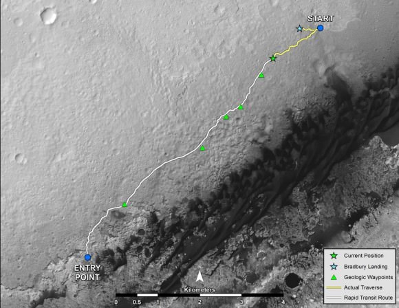
Curiosity's Progress on Rapid Transit Route from 'Glenelg' to Mount Sharp.  Triangles indicate geologic ‘Waypoint’ stopping points along the way.  Curiosity arrived at Waypoint 1 on Sol 392 (Sept 12, 2013). Credit: NASA
Curiosity’s Progress on Rapid Transit Route from ‘Glenelg’ (start at top) to Mount Sharp entry point (bottom). Triangles indicate geologic ‘Waypoint’ stopping points along the way. Curiosity arrived at Waypoint 1 on Sol 392 (Sept 12, 2013). Credit: NASA

‘Waypoint 1’ is an area of intriguing outcrops that was chosen based on high resolution orbital imagery taken by NASA’s Mars Reconnaissance Orbiter (MRO) circling some 200 miles overhead. See route map herein.

In fact the team is rather excited about ‘Waypoint 1’ that’s dominated by the tantalizing rocky outcrop discovered there nicknamed ‘Darwin’.

Although Curiosity will only stay a short time at each of the stops, the measurements collected at each ‘Waypoint’ will provide essential clues to the overall geologic and environmental history of the six wheeled rover’s touchdown zone.

“Waypoint 1 was chosen to help break up the drive,” Grotzinger explained to Universe Today.

“It’s a chance to study outcrops along the way.”

The images from MRO are invaluable in aiding the rover handlers planning activities, selecting Curiosity’s driving route and targeting of the most fruitful science forays during the long trek to Mount Sharp – besides being absolutely crucial for the selection of Gale Crater as the robots landing site in August 2012.

The ‘Darwin’ outcrop may provide more data on the flow of liquid water across the crater floor.

Evolving Excitement Over 'Darwin' Rock Outcrop at 'Waypoint 1'.   For at least a couple of days, the science team of NASA's Mars rover Curiosity is focused on a full-bore science campaign at a tantalizing, rocky site informally called "Darwin."   This view of Darwin was taken with the Mast Camera (Mastcam) on Sol 390 (Sept. 10, 2013). Credit: NASA/JPL-Caltech/Malin Space Science Systems
Evolving Excitement Over ‘Darwin’ Rock Outcrop at ‘Waypoint 1’. For at least a couple of days, the science team of NASA’s Mars rover Curiosity is focused on a full-bore science campaign at a tantalizing, rocky site informally called “Darwin.” This view of Darwin was taken with the Mast Camera (Mastcam) on Sol 390 (Sept. 10, 2013). Credit: NASA/JPL-Caltech/Malin Space Science Systems

The scientists goal is to compare the floor of Gale Crater to the sedimentary layers of 3 mile high (5 kilometer high) Mount Sharp.

Waypoint 1 is just over 1 mile along the approximately 5.3-mile (8.6-kilometer) route from ‘Glenelg’ to the entry point at the base of Mount Sharp.

Curiosity spent over six months investigating the ‘Yellowknife Bay’ area inside Glenelg before departing on July 4, 2013.

What’s the origin of Darwin’s name?

“Darwin comes from a list of 100 names the team put together to designate rocks in the Mawson Quadrangle – Mawson is the name of a geologist who studied Antarctic geology,” Grotzinger told me.

“Recently we left the Yellowknife Quadrangle, so instead of naming rocks after geological formations in Canada’s north, we now turn to formation names of rocks from Antarctica, and Darwin is one of them.

“That will be the theme until we cross into the next quad,” Grotzinger explained.

Curiosity investigates the ‘Darwin’ rock outcrop up close after arriving for a short stay at ‘Waypoint 1’ on Sept 12 (Sol 392). This photo mosaic was assembled from navcam images taken on Sept 12, 2013.   Credit: NASA/JPL-Caltech/Ken Kremer/Marco Di Lorenzo
Curiosity investigates the ‘Darwin’ rock outcrop up close after arriving for a short stay at ‘Waypoint 1’ on Sept 12 (Sol 392). This photo mosaic was assembled from navcam images taken on Sept 12, 2013. Credit: NASA/JPL-Caltech/Ken Kremer/Marco Di Lorenzo

Inside Yellowknife Bay, Curiosity conducted the historic first interplanetary drilling into Red Planet rocks and subsequent sample analysis with her duo of state of the art chemistry labs – SAM and CheMin.

At Yellowknife Bay, the 1 ton robot discovered a habitable environment containing the chemical ingredients that could sustain Martian microbes- thereby already accomplishing the primary goal of NASA’s flagship mission to Mars.

“We want to know how the rocks at Yellowknife Bay are related to what we’ll see at Mount Sharp,” Grotzinger elaborated in a NASA statement. “That’s what we intend to get from the waypoints between them. We’ll use them to stitch together a timeline — which layers are older, which are younger.”

On Sept. 5, Curiosity set a new one-day distance driving record for the longest drive yet by advancing 464 feet (141.5 meters) on her 13th month on the Red Planet.

As Curiosity neared Waypoint 1 she stopped at a rise called ‘Panorama Point’ on Sept. 7, spotted an outcrop of light toned streaks informally dubbed ‘Darwin and used her MastCam telephoto camera to collect high resolution imagery.

Curiosity will use her cameras, spectrometers and robotic arm for contact science and a “full bore science campaign” involving in-depth mineral and chemical composition analysis of Darwin and Waypoint 1 for the next few Sols, or Martian days, before resuming the trek to Mount Sharp that dominates the center of Gale Crater.

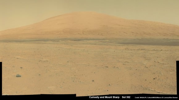
Curiosity Spies Mount Sharp - her primary destination. Curiosity will ascend mysterious Mount Sharp and investigate the sedimentary layers searching for clues to the history and habitability o the Red Planet of billions of years.  This mosaic was assembled from Mastcam camera images taken on Sol 352 (Aug 2, 2013. Credit: NASA/JPL-Caltech/MSSS/ Marco Di Lorenzo/Ken Kremer
Curiosity Spies Mount Sharp – her primary destination. Curiosity will ascend mysterious Mount Sharp and investigate the sedimentary layers searching for clues to the history and habitability o the Red Planet of billions of years. This mosaic was assembled from Mastcam camera images taken on Sol 352 (Aug 2, 2013). Credit: NASA/JPL-Caltech/MSSS/ Marco Di Lorenzo/Ken Kremer

She will not conduct any drilling here or at the other waypoints, several team members have told me, unless there is some truly remarkable ‘Mars-shattering’ discovery.

Why is Curiosity now able to drive longer than ever before?

“We have put some new software – called autonav, or autonomous navigation – on the vehicle right after the conjunction period back in March 2013,” Jim Erickson, Curiosity Project Manager of NASA’s Jet Propulsion Laboratory (JPL), told Universe Today.

“This will increase our ability to drive. But how much it helps really depends on the terrain.”

And so far the terrain has cooperated.

“We are on a general heading of southwest to Mount Sharp,” said Erickson. See the NASA JPL route map.

“We have been going through various options of different planned routes.”

As of today (Sol 394), Curiosity remains healthy, has traveled 2.9 kilometers and snapped over 82,000 images.

If all goes well Curiosity could reach the entry point to Mount Sharp sometime during Spring 2014, at her current driving pace.

Ken Kremer

…………….

Learn more about Curiosity, Mars rovers,LADEE, Cygnus, Antares, MAVEN, Orion and more at Ken’s upcoming presentations

Sep 17/18: LADEE Lunar & Antares/Cygnus ISS Rocket Launches from Virginia”; Rodeway Inn, Chincoteague, VA

Oct 3: “Curiosity, MAVEN and the Search for Life on Mars – (3-D)”, STAR Astronomy Club, Brookdale Community College & Monmouth Museum, Lincroft, NJ, 8 PM

Oct 8: LADEE Lunar & Antares/Cygnus ISS Rocket Launches from Virginia”; Princeton University, Amateur Astronomers Assoc of Princeton (AAAP), Princeton, NJ, 8 PM