NASA’s OSIRIS-REx Asteroid Sampling Probe Completes Instrument Install/Assembly, Enters ‘Test Drive’ Phase

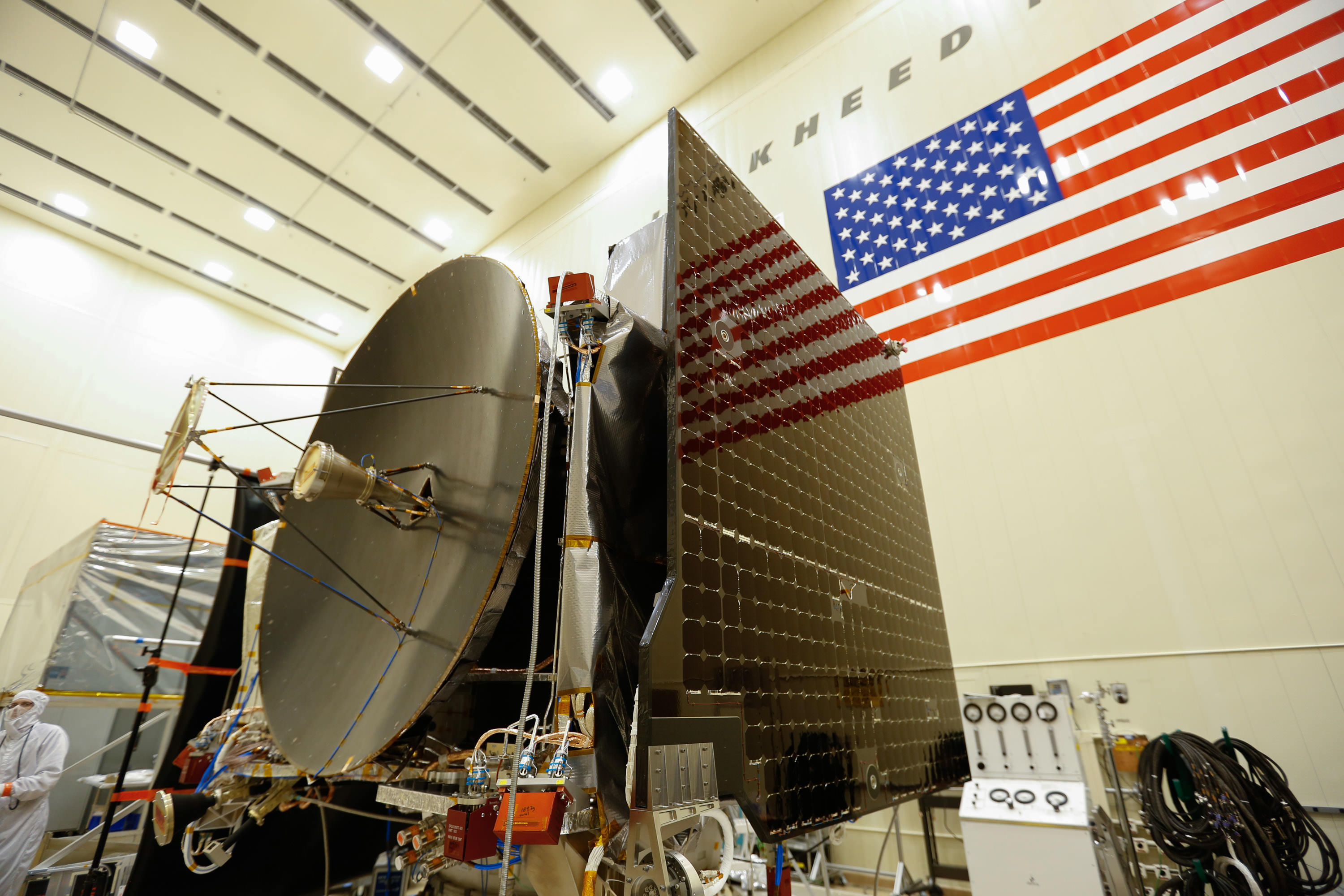
The high gain antenna and solar arrays were installed on the OSIRIS-REx spacecraft prior to it moving to environmental testing. Credits: Lockheed Martin Corporation

OSIRIS-Rex, the first American spacecraft ever aimed at snatching pristine samples from the surface of an asteroid and returning them to Earth for exquisite analysis by researchers world-wide with the most advanced science instruments has successfully completed its assembly phase and moved into the “test drive” phase – just ten months before blastoff, following installation of all its science instruments at Lockheed Martin Space Systems facilities, near Denver, Colorado.

The launch window for OSIRIS-REx opens next fall on September 3, 2016 on a seven-year journey to asteroid Bennu and back. Bennu is a carbon-rich asteroid. OSIRIS-Rex will eventually return the largest sample from space since the American and Soviet Union’s moon landing missions of the 1970s.

The science payload installation was recently completed with attachment of the vehicles three camera instrument suite of cameras and spectrometers known as OCAMS (OSIRIS-REx Camera Suite), which was was designed and built by the University of Arizona’s Lunar and Planetary Laboratory.

OCAMS trio of instruments, PolyCam, MapCam and SamCam, will survey and globally map the surface of Bennu up close at a distance ranging from approximately 5 km to 0.7 km.

“PolyCam, MapCam and SamCam will be our mission’s eyes at Bennu,” said Dante Lauretta, principal investigator for OSIRIS-REx at the University of Arizona, Tucson, in a statement.

“OCAMS will provide the imagery we need to complete our mission while the spacecraft is at the asteroid.”

“All in all it was flawless installation, with the three cameras and the control electronics making it on the spacecraft well in advance of when we originally planned these activities. In general, the OSIRIS-REx ATLO (assembly, test and launch operations) flow has gone smoothly,” said Lauretta in a blog update.

The University of Arizona’s camera suite, OCAMS, sits on a test bench that mimics its arrangement on the OSIRIS-REx spacecraft. The three cameras that compose the instrument – MapCam (left), PolyCam and SamCam – are the eyes of NASA’s OSIRIS-REx mission. They will map the asteroid Bennu, help choose a sample site, and ensure that the sample is correctly stowed on the spacecraft.  Credits: University of Arizona/Symeon Platts
The University of Arizona’s camera suite, OCAMS, sits on a test bench that mimics its arrangement on the OSIRIS-REx spacecraft. The three cameras that compose the instrument – MapCam (left), PolyCam and SamCam – are the eyes of NASA’s OSIRIS-REx mission. They will map the asteroid Bennu, help choose a sample site, and ensure that the sample is correctly stowed on the spacecraft. Credits: University of Arizona/Symeon Platts

For the next five months, NASA’s OSIRIS-REx which stands for Origins, Spectral Interpretation, Resource Identification, Security, Regolith Explorer will undergo a rigorous regime of critical environmental testing to ensure the probe will survive the unforgiving extremes of vacuum, vibration and extreme temperatures it will experience during launch and throughout the life of its planned eight year mission.

The asteroid sampling spacecraft is tracking on budget and ahead of schedule.

“OSIRIS-REx is entering environmental testing on schedule, on budget and with schedule reserves,” said Mike Donnelly, OSIRIS-REx project manager at NASA’s Goddard Space Flight Center in Greenbelt, Maryland, in a statement.

“This allows us to have flexibility if any concerns arise during final launch preparations.”

Bennu is a near-Earth asteroid and was selected for the sample return mission because it “could hold clues to the origin of the solar system and host organic molecules that may have seeded life on Earth,” says NASA.

The spacecraft is equipped with a suite of five science instruments to remotely study the 492 meter wide asteroid.

The instruments were all installed as planned on the spacecraft deck over the past few months so they can all be subjected to the environmental testing together with the spacecraft bus.

“This milestone marks the end of the design and assembly stage,” said Lauretta, in a statement.

“We now move on to test the entire flight system over the range of environmental conditions that will be experienced on the journey to Bennu and back. This phase is critical to mission success, and I am confident that we have built the right system for the job.”

The tests will “simulate the harsh environment of space, including acoustical, separation and deployment shock, vibration, and electromagnetic interference. The simulation concludes with a test in which the spacecraft and its instruments are placed in a vacuum chamber and cycled through the extreme hot and cold temperatures it will face during its journey to Bennu,” say NASA officials.

Video caption: Engineers at Lockheed Martin move the OSIRIS-REx spacecraft onto a rotation fixture. This fixture supports the full weight of the spacecraft and acts as a hinge, orienting the spacecraft at a 90 degree angle, which allows engineers to access the top of the spacecraft much more easily. Credits: Lockheed Martin Corporation

The testing is done to uncover any issues lurking prior next September’s planned liftoff.

“This is an exciting time for the program as we now have a completed spacecraft and the team gets to test drive it, in a sense, before we actually fly it to asteroid Bennu,” said Rich Kuhns, OSIRIS-REx program manager at Lockheed Martin Space Systems.

“The environmental test phase is an important time in the mission as it will reveal any issues with the spacecraft and instruments, while here on Earth, before we send it into deep space.”

After the testing is complete by next May, the spacecraft will ship from Lockheed Martin’s Denver facility to NASA’s Kennedy Space Center, where it will undergo final prelaunch preparations and transport to the launch pad at Cape Canaveral.
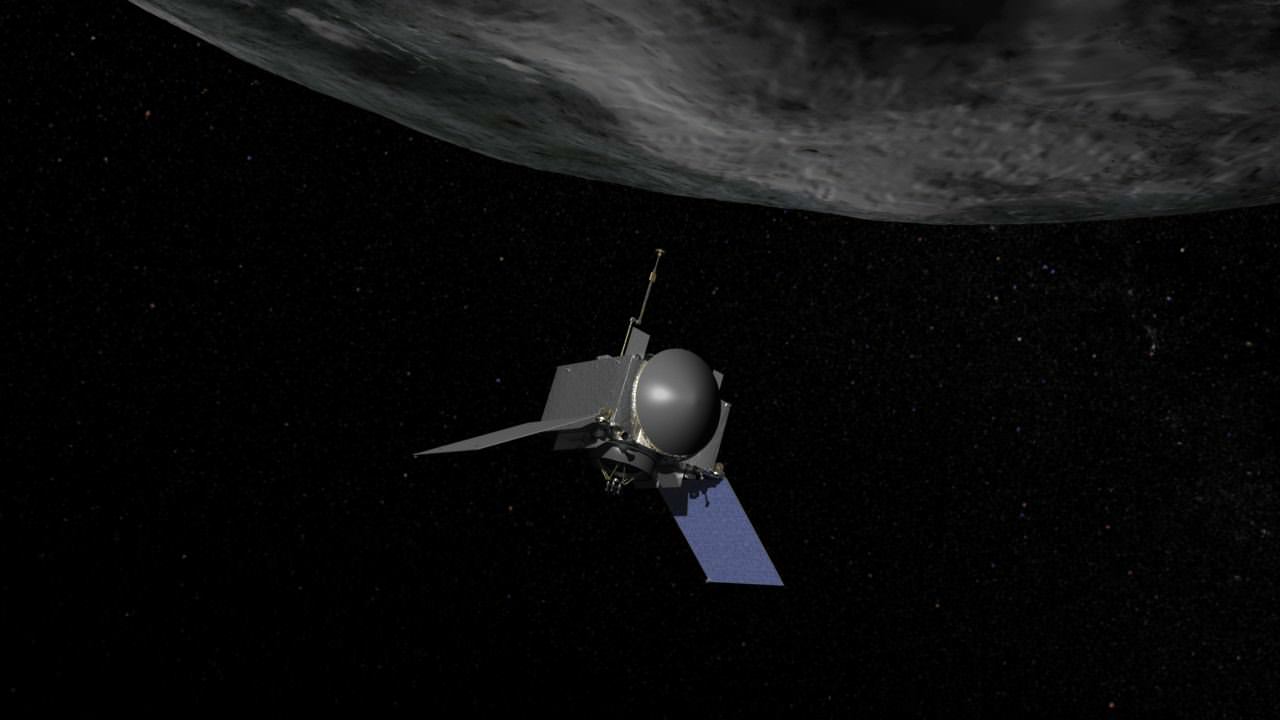
Artist concept of OSIRIS-REx, the first U.S. mission to return samples from an asteroid to Earth. Credit: NASA/Goddard
Artist concept of OSIRIS-REx, the first U.S. mission to return samples from an asteroid to Earth.
Credit: NASA/Goddard

OSIRIS-REx is scheduled for launch in September 2016 from Cape Canaveral Air Force Station in Florida aboard a United Launch Alliance Atlas V 411 rocket, which includes a 4-meter diameter payload fairing and one solid rocket motor. Only three Atlas V’s have been launched in this configuration.

“This is an exciting time,” says Lauretta.

The spacecraft will reach Bennu in 2018. OSIRIS-REx will gather rocks and soil and bring at least a 60-gram (2.1-ounce) sample back to Earth in 2023 for study by researchers here with all the most sophisticated science instruments available.

Bennu is an unchanged remnant from the collapse of the solar nebula and birth of our solar system some 4.5 billion years ago, little altered over time.

OSIRIS-REx is the third mission in NASA’s New Frontiers Program, following New Horizons to Pluto and Juno to Jupiter, which also launched on Atlas V rockets.

NASA’s Goddard Space Flight Center in Greenbelt, Maryland, is responsible for overall mission management.

OSIRIS-REx complements NASA’s Asteroid Initiative – including the Asteroid Redirect Mission (ARM) which is a robotic spacecraft mission aimed at capturing a surface boulder from a different near-Earth asteroid and moving it into a stable lunar orbit for eventual up close sample collection by astronauts launched in NASA’s new Orion spacecraft. Orion will launch atop NASA’s new SLS heavy lift booster concurrently under development.

OSIRIS-REx logo
OSIRIS-REx logo

Stay tuned here for Ken’s continuing Earth and planetary science and human spaceflight news.

Ken Kremer

NASA Astronaut Scott Kelly Sets US Record for Most Time in Space – At the ‘Speed of Sound’: Video

NASA Astronaut Scott Kelly works inside the U.S. Destiny Laboratory. Destiny is the primary research laboratory for U.S. payloads, supporting a wide range of experiments and studies contributing to health, safety and quality of life for people all over the world. Credit: NASA

Video Caption: See NASA astronaut Scott Kelly’s extraterrestrial exploits as he breaks US record for time in space in this music video set to the song ‘Speed of Sound’ by Coldplay. Credit: NASA/Coldplay

NASA astronaut Scott Kelly has just broken the American record for most time spent in space – at 383 days and counting – as part of his groundbreaking yearlong mission living aboard the International Space Station (ISS), where he currently serves as station commander.

See Kelly break the US spaceflight endurance record on the ISS at the “SPEED OF SOUND” in the beautifully space themed music video (above) set to the worldwide hit song by rock band Coldplay.

The video recounts a flurry of highlights from the yearlong space station mission with his partner, Russian cosmonaut Mikahail Kornienko, and the rest of the rotating cast of international crewmates.

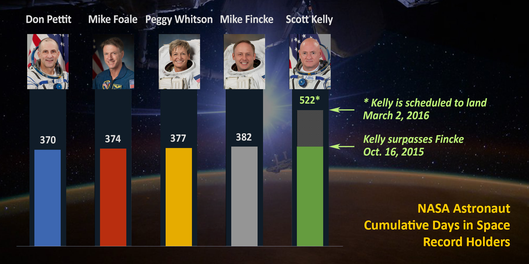
On October 16, 2015, Kelly surpassed the US time in space record of 382 days previously held by NASA astronaut Mike Fincke.

The ‘1 Year ISS mission’ is aimed at conducting research to explore the impact of long term stays in space on the human body and aid NASA’s long term plans for a human ‘Journey to Mars’ in the 2030s.

“Records are meant to be broken. Look fwd to one of my colleagues surpassing my end 500+ days on our #JourneyToMars!’ Kelly tweeted from the ISS about his record breaking achievement.

As of today, October 20, Kelly has reached the 206 day mark aboard the ISS, of his planned 342 days in space. He’s now about a month past the half way mark.

In addition to his scientific research, Kelly has been a prolific photographer of all things space – including natural wonders and natural disasters like Hurricane Joaquin.

Here’s his newly released photo titled ‘Earth Art From Australia.’

‘Earth Art From Australia.’ @StationCDRKelly captured 17 pics from @Space_Station during a single flyover of Australia from 12/13 Oct 2015.  Credit: NASA/Scott Kelly
‘Earth Art From Australia.’ @StationCDRKelly captured 17 pics from @Space_Station during a single flyover of Australia from 12/13 Oct 2015. Credit: NASA/Scott Kelly

See the NASA graphic herein showing the US astronauts who have accumulated the most spaceflight experience to date.

Station Commander Scott Kelly passed astronaut Mike Fincke, also a former station commander, on Oct. 16, 2015, for most cumulative days living and working in space by a NASA astronaut (383 days and counting). Kelly is scheduled to come home March 2, 2016, for a record total 522 days in space.  Credit: NASA
Station Commander Scott Kelly passed astronaut Mike Fincke, also a former station commander, on Oct. 16, 2015, for most cumulative days living and working in space by a NASA astronaut (383 days and counting). Kelly is scheduled to come home March 2, 2016, for a record total 522 days in space. Credit: NASA

Kelly accumulated his time in space during multiple spaceflights. Altogether this is his fourth mission and second long duration stay aboard the ISS. This flight also marks his second stint as station commander – as a member of the current Expedition 45 crew.

To be sure, Kelly is not merely passing Fincke’s record days but actually smashing through it by many months because he still has a long way to go until he returns home to Earth.

At the conclusion of his yearlong mission when he plummets back home in a Russian Soyuz capsule – along with Kornienko – on March 2, 2016, he will have compiled 522 total days living in space.

Kelly will also become the first American to spend a year in space, a feat previously achieved by only four Russian cosmonauts – all in the 1980s and 1990s aboard Russia’s Mir space station.

Next week on Thursday, Oct. 29, Kelly will break another American record for the single-longest spaceflight.

“On Oct. 29 on his 216th consecutive day in space, he will surpass astronaut Michael Lopez-Alegria’s record for the single-longest spaceflight by an American. Lopez-Alegria spent 215 days in space as commander of the Expedition 14 crew in 2006.”

Scott Kelly, U.S. astronaut and commander of the current Expedition 45 crew, broke the US record for time spent in space on Oct. 16, 2015. Credit: NASA

Kelly and Kornienko are spending a year aboard the ISS, “testing the limits of human research, space exploration and the human spirit,” says NASA officials.

The pair launched to the ISS in March 2015 along with Russian cosmonaut Gennady Padalka. He recently returned to Earth in September 2015 after setting the record for most time spent in space by any Earthling – with an accumulated total of 879 days living and working in space.

During their 342 days in space, Kelly and Kornienko are specifically “participating in studies in space that provide new insights into how the human body adjusts to weightlessness, isolation, radiation and stress of long-duration spaceflight. Kelly’s twin brother, former astronaut Mark Kelly, will participate in parallel twin studies on Earth to help scientists compare the effects on the body and mind in space.”

“The investigations in progress on the space station will help scientists better understand how to protect astronauts as they travel into deep space and eventually on missions to the Red Planet. The strong U.S.-Russian collaboration during the one-year mission is an example of the global cooperation aboard the space station that is a blueprint for international partnerships to advance shared goals in space exploration. Strengthening international partnerships will be key in taking humans deeper into the solar system,” according to NASA.

Hurricane Joaquin captured on Oct. 2, 2015 by NASA Astronaut Scott Kelly from the International Space Station. Credit: NASA/Scott Kelly

Kelly and the crew are also surely looking forward to the arrival of the Orbital ATK resupply ship carrying science experiments, provisions, spare parts, food and other goodies after it blasts off from Florida on Dec. 3 – detailed in my story here.

Stay tuned here for Ken’s continuing Earth and planetary science and human spaceflight news.
Ken Kremer

Morning Aurora From the Space Station. NASA astronaut Scott Kelly (@StationCDRKelly) captured this photograph of the green lights of the aurora from the International Space Station on Oct. 7, 2015. Credit: NASA

NASA Astronaut Scott Kelly and Russian Cosmonaut Mikhail Kornienko comprise  the first ever ISS 1 Year Crew
NASA Astronaut Scott Kelly and Russian Cosmonaut Mikhail Kornienko comprise the first ever ISS 1 Year Crew

See EPIC Views of Rotating Earth Daily from NASA’s New DSCOVR Observatory Website

Earth rotates through an entire day as captured in this animation of 22 still images taken on Sept. 17, 2015 by NASA’s Earth Polychromatic Imaging Camera (EPIC) camera on the Deep Space Climate Observatory (DSCOVR) spacecraft. Credits: NASA

At long last, beautiful new high resolution views of the rotating Earth can be seen daily by everyone at a new NASA website – all courtesy of images taken by NASA’s EPIC camera on board the Deep Space Climate Observatory (DSCOVR) spacecraft. And as seen in the time-lapse animation above, they provide a wonderful new asset for students everywhere to learn geography that’s just a finger tip away!

The EPIC camera, which stands for Earth Polychromatic Imaging Camera (EPIC), is located a million miles away on the DSCOVR real time space weather monitoring satellite and is designed to take full disk color images of the sunlit side of our home planet multiple times per day.

The EPIC NASA images are literally just a finger tip away, after a 17 year wait to get the satellite into the launch queue since it was first proposed by former VP Al Gore. They are all easily viewed at NASA’s new EPIC camera website which went online today, Monday, October 19, 2015.

To see the daily sequence of rotating images, visit the EPIC website link: http://epic.gsfc.nasa.gov/

This EPIC image was taken on Oct.17 and shows the Australian continent and a portion of Asia.

EPIC image taken on Oct. 17, 2015 showing the continent of Australia and a portion of Asia. Credit: NASA

An annotated guide map illustration identifying the visible land masses accompanies each EPIC image and follows along as the Earth rotates daily.

What a great geography learning tool for student classrooms worldwide!

Annotated guide map identifying the visible land masses accompanies each EPIC image. Credit: NASA

DSCOVR is a joint mission between NOAA, NASA, and the U.S Air Force (USAF) that is managed by NOAA. The satellite and science instruments were provided by NASA and NOAA.

EPIC is a four megapixel CCD camera and telescope mounted on DSCOVR and orbiting around the L1 Lagrange Point – a neutral gravity point that lies on the direct line between Earth and the sun.

NASA says that once per day they will post “at least a dozen new color images of Earth acquired from 12 to 36 hours earlier” taken by the agency’s EPIC camera. The EPIC images will be stored in an archive searchable by date and continent.

The image sequence will show “the Earth as it rotates, thus revealing the whole globe over the course of a day.”

“The effective resolution of the DSCOVR EPIC camera is somewhere between 6.2 and 9.4 miles (10 and 15 kilometers),” said Adam Szabo, DSCOVR project scientist at NASA’s Goddard Space Flight Center, Greenbelt, Maryland, in a statement.

“The color Earth images are created by combining three separate single-color images to create a photographic-quality image equivalent to a 12-megapixel camera. The camera takes a series of 10 images using different narrowband filters — from ultraviolet to near infrared — to produce a variety of science products. The red, green and blue channel images are used to create the color images. Each image is about 3 megabytes in size.”

EPIC will capture “a constant view of the fully illuminated Earth as it rotates, providing scientific observations of ozone, vegetation, cloud height and aerosols in the atmosphere.”

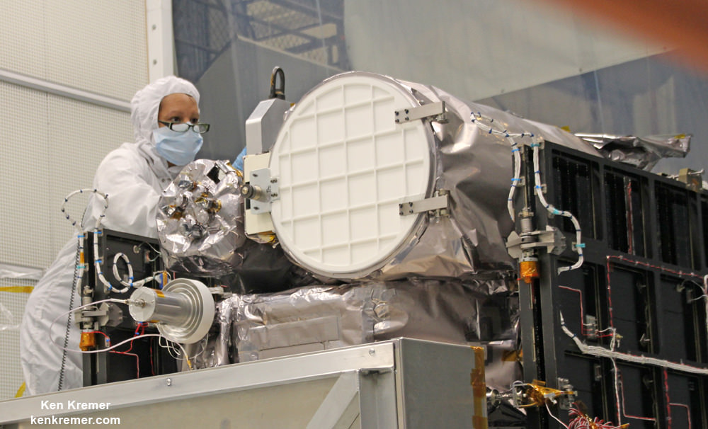
Technician works on NASA Earth science instruments and Earth imaging EPIC camera (white circle) housed on NOAA/NASA Deep Space Climate Observatory (DSCOVR) inside NASA Goddard Space Flight Center clean room in November 2014.  Credit: Ken Kremer/kenkremer.com
Technician works on NASA Earth science instruments and Earth imaging EPIC camera (white circle) housed on NOAA/NASA Deep Space Climate Observatory (DSCOVR) inside NASA Goddard Space Flight Center clean room in November 2014. Credit: Ken Kremer/kenkremer.com

The couch sized probe was launched atop a SpaceX Falcon 9 on Feb. 11, 2015 from Cape Canaveral, Florida, to start the million mile journey to its deep space observation post at L1. The rocket was funded by the USAF.

The primary goal of the $340 million DSCOVR satellite is to monitor the solar wind and aid very important forecasts of space weather at Earth from L1.

L1 is located 1.5 million kilometers (932,000 miles) sunward from Earth. At L1 the gravity between the sun and Earth is perfectly balanced and the DSCOVR satellite orbits about that spot just like a planet.

The mission is vital because its solar wind observations are crucial to maintaining accurate space weather forecasts to protect US infrastructure such as power grids, aviation, planes in flight, all types of Earth orbiting satellites for civilian and military needs, telecommunications, ISS astronauts and GPS systems.

This animation shows images of the far side of the moon, illuminated by the sun, as it crosses between the DISCOVR spacecraft's Earth Polychromatic Imaging Camera (EPIC) camera and telescope, and the Earth - one million miles away.  Credit: NASA/NOAA
This animation shows images of the far side of the moon, illuminated by the sun, as it crosses between the DISCOVR spacecraft’s Earth Polychromatic Imaging Camera (EPIC) camera and telescope, and the Earth – one million miles away. Credit: NASA/NOAA

DSCOVR was first proposed in 1998 by then US Vice President Al Gore as the low cost ‘Triana’ satellite to take near continuous views of the Earth’s entire globe to feed to the internet as a means of motivating students to study math and science.

It was also dubbed “Goresat.”

The probe was eventually resurrected and partially rebuilt at NASA Goddard Space Flight Center as a much more capable Earth science satellite that would also conduct the space weather observations.

But Triana was shelved for purely partisan political reasons and the satellite was placed into storage at NASA Goddard.

Thus the practical and teachable science and daily scenes of the gorgeously rotating Earth were lost – until now!

Former VP Al Gore was clearly delighted with today’s launch of NASA’s EPIC website in this pair of tweets:

“Today @NASA launched its site for #DSCOVR’s daily images. I look forward to seeing more from #DSCOVR,” tweeted Al Gore.

“DSCOVR’s site displaying new daily images of Earth from L1 was launched today! Congratulations to all those who made this happen!”

Stay tuned here for Ken’s continuing Earth and planetary science and human spaceflight news.

Ken Kremer

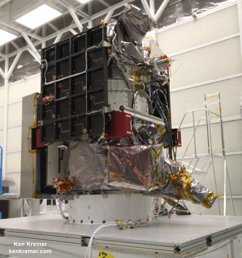
NOAA/NASA Deep Space Climate Observatory (DSCOVR) undergoes processing in NASA Goddard Space Flight Center clean room. Solar wind instruments at right. DSCOVER will launch in February 2015 atop SpaceX Falcon 9 rocket.  Credit: Ken Kremer/kenkremer.com
NOAA/NASA Deep Space Climate Observatory (DSCOVR) undergoes processing in NASA Goddard Space Flight Center clean room. Solar wind instruments at right. DSCOVER launched in February 2015 atop SpaceX Falcon 9 rocket. Credit: Ken Kremer/kenkremer.com
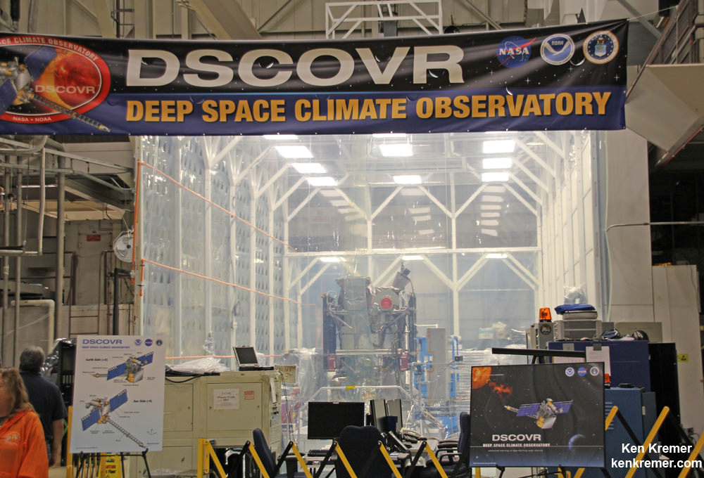
NOAA/NASA/USAF Deep Space Climate Observatory (DSCOVR) undergoes processing in NASA Goddard Space Flight Center clean room.  Probe will launch in February atop SpaceX Falcon 9 rocket.  Credit: Ken Kremer - kenkremer.com
NOAA/NASA/USAF Deep Space Climate Observatory (DSCOVR) undergoes processing in NASA Goddard Space Flight Center clean room. Probe launched in February 2015 atop SpaceX Falcon 9 rocket. Credit: Ken Kremer/kenkremer.com

Cygnus Cargo Craft Comes Together for Space Station ‘Return to Flight’ Blastoff in December

Cygnus service module built by Orbital ATK in their Dulles, Virginia cleanroom is shown here with unfurled Ultraflex solar panels that will fly for the first time with mated pressurized module on the OA-4 ISS resupply mission on ULA Atlas V rocket on Dec. 3, 2015 from Cape Canaveral, Florida. Credit: Orbital ATK
Cygnus service module built by Orbital ATK in their Dulles, Virginia cleanroom is shown here with unfurled Ultraflex solar panels that will fly for the first time with mated pressurized module on the OA-4 ISS resupply mission on ULA Atlas V rocket on Dec. 3, 2015 from Cape Canaveral, Florida.    Credit: Orbital ATK
Cygnus service module built by Orbital ATK in their Dulles, Virginia cleanroom is shown here with unfurled UltraFlex solar panels that will fly for the first time with mated pressurized module on the OA-4 ISS resupply mission on ULA Atlas V rocket on Dec. 3, 2015 from Cape Canaveral, Florida. Credit: Orbital ATK
See OA-4 mission patch and hardware photos below

The biggest and heaviest Cygnus commercial cargo craft ever built by Orbital ATK is coming together at the Kennedy Space Center as the launch pace picks up steam for its critical ‘Return to Flight’ resupply mission to the space station for NASA. Cygnus is on target for an early December blastoff from Florida and the Orbital ATK team is “anxious to get flying again.”

“We are very excited about the upcoming [OA-4] cargo mission and returning to flight,” said Frank DeMauro, Orbital ATK Vice President for Human Spaceflight Systems Programs, in an exclusive interview with Universe Today. Continue reading “Cygnus Cargo Craft Comes Together for Space Station ‘Return to Flight’ Blastoff in December”

ExoMars Heads to the Red Planet in 2016

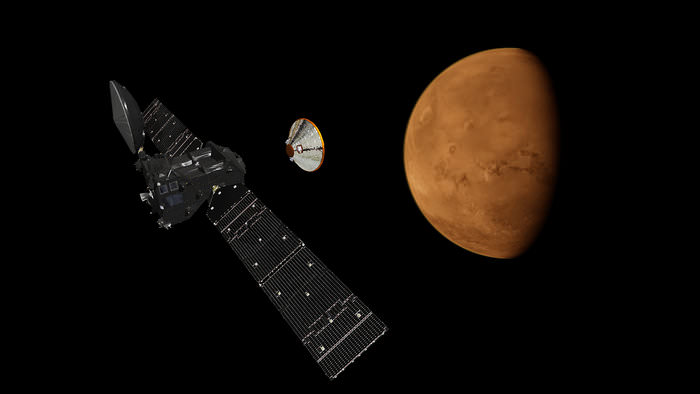
An artist's concept of the S EDM Lander separating from the ExoMars Trace Gas Orbiter. Image Credit: ESA

The 2016 launch window for Mars missions is fast approaching along with opposition, and ESA is refining its target window for ExoMars. Mars launch season offers the optimal time to make the trip from Earth to Mars, as missions prepare to break the surly bonds and head towards the Red Planet next spring. NASA’s InSight lander will also make the trip.

ExoMars is the first joint European Space Agency (ESA) Roscosmos mission to the Red Planet. The ExoMars Trace Gas Orbiter is under contract to Thales Alenia Space, and the EDM stationary lander dubbed Schiaparelli after the 19th century Italian astronomer is being constructed by Airbus Defense and Space. This would be Russia’s first successful Mars lander mission for over a dozen tries if successful.

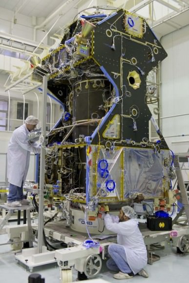
The ExoMars Trace gas Orbiter in the lab. Image credit: ESA
The ExoMars Trace Gas Orbiter in the lab. Image credit: ESA

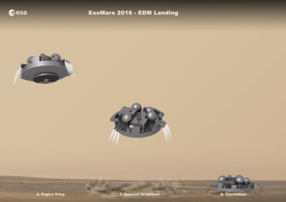
The ExoMars project is a two-part mission, and will culminate in an ExoMars rover in 2018. The key objective for the Trace Gas Orbiter, lander and rover to follow in 2018 is to seek out the controversial source of methane on Mars. A product of biology—think bovine flatulence—on Earth, researchers have proposed various sources—inorganic and otherwise—as a source of the anomalous methane seen in the Martian atmosphere. The Trace Gas Orbiter will remain on-station in orbit through 2018 to relay communications from the ExoMars rover. The Entry, Descent and Landing Demonstrator Module Schiaparelli will demonstrate key technologies for landing, including a hybrid Buck Rodgers fins-first style retro-rocket landing reminiscent of Viking, along with a deformable underside meant to absorb impact.

Image credit: ESA
The landing sequence for the EDL Lander. Image credit: ESA

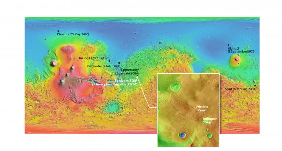
The landing with be a dramatic one on Meridiani Planum at the expected height of dust storm season, and we may get some interesting footage from the onboard descent camera. Along with weather and atmospheric measurements, the EDM Lander will also make the first electrical field measurements from the surface of Mars.

Image credit: MOLA Science Team and NASA/JPL/Arizona State Unversity
The landing ellipse for EDL. Note that its very close to the NASA rover Opportunity. Image credit: MOLA Science Team and NASA/JPL/Arizona State University

Unfortunately, EDM’s life will be short; Roscosmos originally intended to supply a 100-watt plutonium-powered RTG for the lander, but later opted due to export control to use an on-board battery. The EDM’s lifespan will be measured in a few days, at best.

Heading to Mars in 2016

An issue related to two propulsion system sensors aboard the EDM Lander recently prompted mission planners to opt for a launch for ExoMars at the end of the window next year, with liftoff set for March 14th atop a Proton rocket from the Baikonur Cosmodrome in Kazakhstan instead of January, as originally intended. NASA’s Mars InSight will depart Earth for the Red Planet just ten days earlier on March 4th from Vandenberg AFB in a rare dramatic night shot of an Atlas 5 rocket deploying an interplanetary mission from the US West Coast. InSight’s primary objective is to study seismic activity and the Martian interior, and will land in one of four selected sites (1 primary and 3 backup) in Elysium Planitia on September 28th, 2016.

Naturally, ESA and Roscomos are taking every precaution to assure the success of ExoMars and EDM. The 2011 failure of Phobos-Grunt highlighted the perils of tempting the ‘Great Martian Ghoul’ with more tasty spacecraft. Space is hard, and landing on Mars even more so.

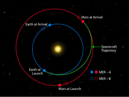
Opposition 2016 for Mars occurs on May 22nd, 2016. Mars is always high in the early morning sky a few months prior to opposition, presenting an optimal window to send spacecraft to the Red Planet on the most efficient in trajectory in terms of fuel and time. This 3-month wide window comes around every 26 months leading up to opposition season. Oppositions of Mars are now getting more favorable, and the next opposition after 2016 in 2018 will be nearly as favorable as the historic 2003 event.

Image credit: NASA/JPL
Typical Earth to Mars launch trajectories, in this case, for NASA’s twin Mars Exploration Rovers.  Image credit: NASA/JPL

Our robots are swiftly colonizing Mars on our behalf. Here’s a Who’s Who scorecard of functioning spacecraft. On the surface: NASA’s Opportunity and Mars Curiosity rovers. In orbit: Mars Odyssey, (Since 2001!) Mars Express, HiRISE, India’s Mars Orbiter, and MAVEN. Add the ExoMars 2016 and 2018 missions, InSight and the Mars 2020 rover for NASA, and we’ve truly established a redundant sort of ‘telepresence’ on and around Mars.

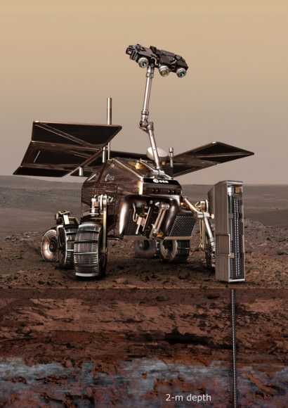
An artist's conception of the ExoMars 2018 rover on the Red Planet. Image credit: ESA
An artist’s conception of the ExoMars 2018 rover on the Red Planet. Image credit: ESA

Will the EDM Lander become the first successful non-NASA lander to approach the Red Planet?  Keep an eye on the Insight and the first of two ExoMars missions, as Earth invades Mars in 2016!

Opportunity Rover Prospecting for Water Altered Minerals at Crater Rim in Marathon Valley

Panoramic view from NASA’s Opportunity rover looking down the floor of Marathon Valley and out to the vast expense of Endeavour Crater. Marathon Valley holds significant deposits of water altered clay minerals. This composite photo mosaic shows the rover’s robotic arm reaching out at left to investigate Martian rocks holding clues to the planets watery past, and robot shadow and wheel tracks visible at right. The mosaic combines a flattened fisheye hazcam image at left with a trio of navcam camera images taken on Sol 4144 (Sept. 20, 2015) and colorized. Credit: NASA/JPL/Cornell/Ken Kremer/kenkremer.com/Marco Di Lorenzo

As NASA’s Opportunity rover approaches the 12th anniversary of landing on Mars, her greatest science discoveries yet are likely within grasp in the coming months since she has successfully entered Marathon Valley from atop a Martian mountain and is now prospecting downhill for outcrops of water altered clay minerals.

The valley is the gateway to alien terrain holding significant caches of the water altered minerals that formed under environmental conditions conducive to support Martian microbial life forms, if they ever existed. But as anyone who’s ever climbed down a steep hill knows, you have to be extra careful not to slip and slide and break something, no matter how beautiful the view is – Because no one can hear you scream on Mars! See the downward looking valley view above.

After a years long Martian mountain climbing and mountain top exploratory trek, Opportunity entered a notch named Marathon Valley from atop a breathtakingly scenic ridge overlook atop the western rim of Endeavour Crater.

Marathon Valley measures about 300 yards or meters long and cuts downhill through the west rim of Endeavour crater from west to east. Endeavour crater spans some 22 kilometers (14 miles) in diameter.

See our photo mosaics illustrating Opportunity’s view around and about Marathon Valley and Endeavour Crater, created by the image processing team of Ken Kremer and Marco Di Lorenzo.

Our mosaic above affords a downward looking view from Marathon Valley on Sol 4144, Sept. 20. It uniquely combines raw images from the hazcam and navcam cameras to gain a wider perspective panoramic view of the steep walled valley, and also shows the rover at work stretching out the robotic arm to potential clay mineral rock targets at left. Opportunity’s shadow and wheel tracks are visible at right.

Mosaic view from Opportunity rover looking along the high walls and down the floor of Marathon Valley with deposits of water altered clay minerals and out to the vast expense of Endeavour Crater. This navcam camera photo mosaic was assembled from images taken on Sol 4159  (Oct. 5, 2015) and colorized.  Credit: NASA/JPL/Cornell/Marco Di Lorenzo/Ken Kremer/kenkremer.com
Mosaic view from Opportunity rover looking along the high walls and down the floor of Marathon Valley with deposits of water altered clay minerals and out to the vast expense of Endeavour Crater. This navcam camera photo mosaic was assembled from images taken on Sol 4159 (Oct. 5, 2015) and colorized. Credit: NASA/JPL/Cornell/Marco Di Lorenzo/Ken Kremer/kenkremer.com

In late July, Opportunity began the decent into the valley from the western edge and started investigating scientifically interesting rock targets by conducting a month’s long “walkabout” survey ahead of the upcoming frigid Martian winter – the seventh since touchdown at Meridiani Planum in January 2004.

The walkabout was done to identify targets of interest for follow up scrutiny in and near the valley floor. Opportunity’s big sister Curiosity conducted a similarly themed “walkabout” at the base of Mount Sharp near her landing site located on the opposite side of the Red Planet.

“The valley is somewhat like a chute directed into the crater floor, which is a long ways below. So it is somewhat scary, but also pretty interesting scenery,” writes Larry Crumpler, a science team member from the New Mexico Museum of Natural History & Science, in a mission update.

“Its named Marathon Valley because the rover traveled one marathon’s distance to reach it,” Prof. Ray Arvidson, the rover Deputy Principal Investigator of Washington University told Universe Today.

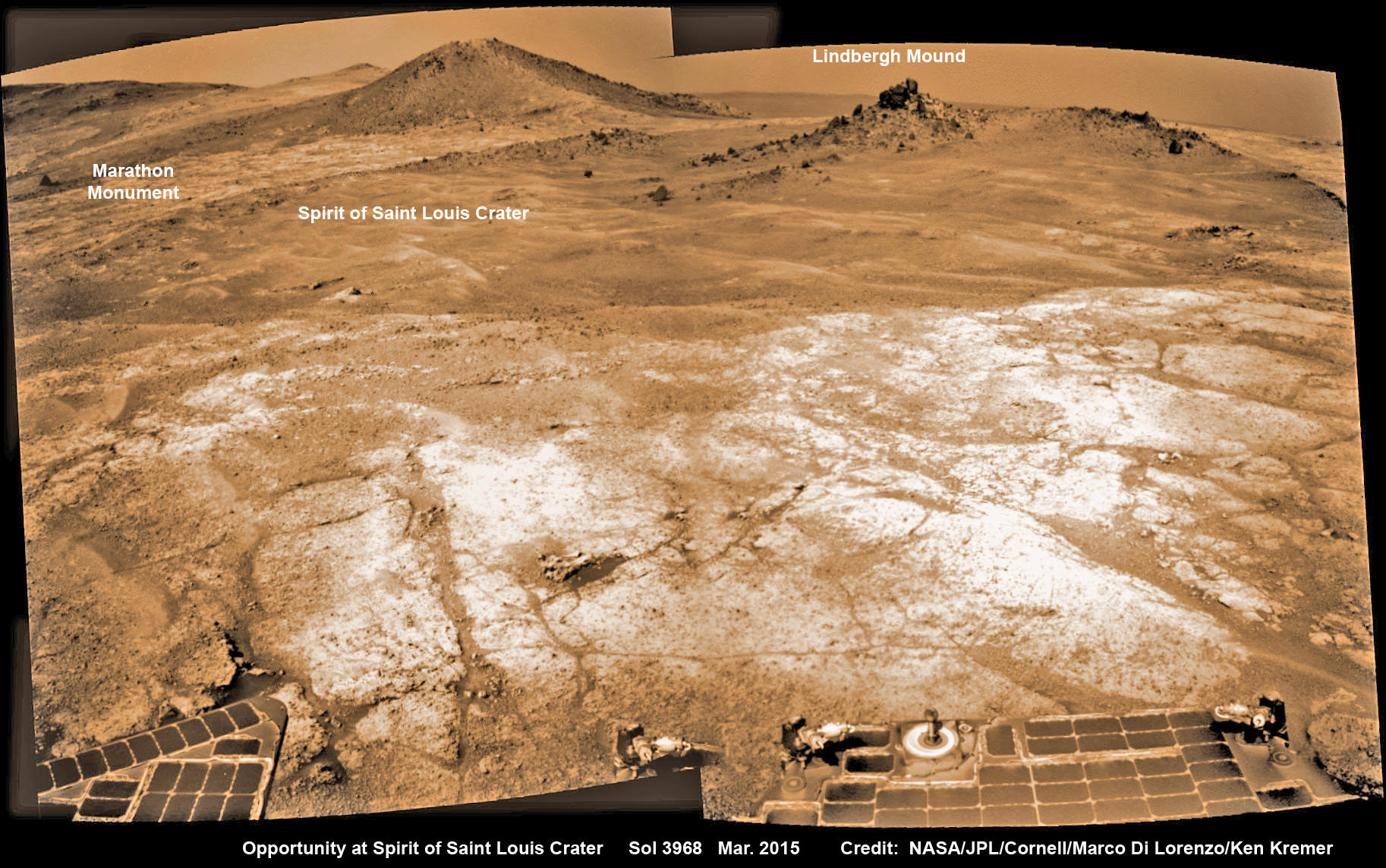
The NASA rover exceeded the distance of a marathon on the surface of Mars on March 24, 2015, Sol 3968. Opportunity has now driven over 26.46 miles (42.59 kilometers) over nearly a dozen Earth years.

Opportunity’s view (annotated) on the day the NASA rover exceeded the distance of a marathon on the surface of Mars on March 24, 2015, Sol 3968 with features named in honor of Charles Lindbergh’s historic solo flight across the Atlantic Ocean in 1927. Rover stands at Spirit of Saint Louis Crater near mountaintop at Marathon Valley overlook and Martian cliffs at Endeavour crater holding deposits of water altered clay minerals.  This navcam camera photo mosaic was assembled from images taken on Sol 3968 (March 24, 2015) and colorized.  Credit: NASA/JPL/Cornell/Marco Di Lorenzo/Ken Kremer/kenkremer.com
Opportunity’s view (annotated) on the day the NASA rover exceeded the distance of a marathon on the surface of Mars on March 24, 2015, Sol 3968 with features named in honor of Charles Lindbergh’s historic solo flight across the Atlantic Ocean in 1927. Rover stands at Spirit of Saint Louis Crater near mountaintop at Marathon Valley overlook and Martian cliffs at Endeavour crater holding deposits of water altered clay minerals. This navcam camera photo mosaic was assembled from images taken on Sol 3968 (March 24, 2015) and colorized. Credit: NASA/JPL/Cornell/Marco Di Lorenzo/Ken Kremer/kenkremer.com

Now for the first time in history, a human emissary has arrived to conduct an up close inspection of and elucidate clues into this regions potential regarding Martian habitability.

The ancient, weathered slopes around Marathon Valley hold a motherlode of ‘phyllosilicate’ clay minerals, based on data obtained from the extensive Mars orbital measurements gathered by the CRISM spectrometer on NASA’s Mars Reconnaissance Orbiter (MRO) – accomplished earlier at the direction of Arvidson.

'Hinners Point' Above Floor of 'Marathon Valley' on Mars. This Martian scene shows contrasting textures and colors of "Hinners Point," at the northern edge of "Marathon Valley," and swirling reddish zones on the valley floor to the left. Credit: NASA/JPL-Caltech/Cornell Univ./Arizona State Univ.
‘Hinners Point’ Above Floor of ‘Marathon Valley’ on Mars. This Martian scene shows contrasting textures and colors of “Hinners Point,” at the northern edge of “Marathon Valley,” and swirling reddish zones on the valley floor to the left. Credit: NASA/JPL-Caltech/Cornell Univ./Arizona State Univ.

Initially the science team was focused on investigating the northern region of the valley while the sun was still higher in the sky and generating more power for research activities from the life giving solar arrays.

“We have detective work to do in Marathon Valley for many months ahead,” said Opportunity Deputy Principal Investigator Ray Arvidson, of Washington University in St. Louis.

But now that the rover is descending into a narrow valley with high walls, the rovers engineering handlers back on Earth have to exercise added caution regarding exactly where they send the Opportunity on her science forays during each sols drive, in order to maintain daily communications.

The high walls to the north and west of the valley ridgeline has already caused several communications blackouts for the “low-elevation Ultra-High-Frequency (UHF) relay passes to the west,” according to the JPL team controlling the rover.

Indeed on two occasions in mid September – coinciding with the days just before and after our Sol 4144 (Sept. 20) photo mosaic view above, “no data were received as the orbiter’s flight path was below the elevation on the valley ridgeline.

On Sept 17 and Sept. 21 “the high ridgeline of the valley obscured the low-elevation pass” and little to no data were received. However the rover did gather imagery and spectroscopic measurements for later transmission.

Now that winter is approaching the rover is moving to the southern side of Marathon Valley to soak up more of the sun’s rays from the sun-facing slope and continue research activities.

“During the Martian late fall and winter seasons Opportunity will conduct its measurements and traverses on the southern side of the valley,” says Arvidson.

“When spring arrives the rover will return to the valley floor for detailed measurements of outcrops that may host the clay minerals.”

The shortest-daylight period of this seventh Martian winter for Opportunity will come in January 2016.

NASA’s Opportunity Rover scans along a spectacular overlook toward Marathon Valley on March 3, 2015, showing flat-faced rocks exhibiting a completely new composition from others examined earlier. Marathon Valley and Martian cliffs on Endeavour crater hold deposits of water altered clay minerals. This navcam camera photo mosaic was assembled from images taken on Sol 3948 (March 3, 2015) and colorized. Credit: NASA/JPL/Cornell/Ken Kremer/kenkremer.com/Marco Di Lorenzo

As of today, Sol 4168, Oct, 15, 2015 Opportunity has taken over 206,300 images and traversed over 26.46 miles (42.59 kilometers).

Stay tuned here for Ken’s continuing Earth and planetary science and human spaceflight news.

Ken Kremer

Nearly 12 Year Traverse Map for NASA’s Opportunity rover from 2004 to 2015. This map shows the entire path the rover has driven during almost 12 years and more than a marathon runners distance on Mars for over 4163 Sols, or Martian days, since landing inside Eagle Crater on Jan 24, 2004 - to current location at the western rim of Endeavour Crater and descending into Marathon Valley. Rover surpassed Marathon distance on Sol 3968 and marked 11th Martian anniversary on Sol 3911. Opportunity discovered clay minerals at Esperance – indicative of a habitable zone - and is currently searching for more at Marathon Valley.  Credit: NASA/JPL/Cornell/ASU/Marco Di Lorenzo/Ken Kremer/kenkremer.com
Nearly 12 Year Traverse Map for NASA’s Opportunity rover from 2004 to 2015
This map shows the entire path the rover has driven during almost 12 years and more than a marathon runners distance on Mars for over 4163 Sols, or Martian days, since landing inside Eagle Crater on Jan 24, 2004 – to current location at the western rim of Endeavour Crater and descending into Marathon Valley. Rover surpassed Marathon distance on Sol 3968 and marked 11th Martian anniversary on Sol 3911. Opportunity discovered clay minerals at Esperance – indicative of a habitable zone – and is currently searching for more at Marathon Valley. Credit: NASA/JPL/Cornell/ASU/Marco Di Lorenzo/Ken Kremer/kenkremer.com

Curiosity Snaps ‘Big Sky’ Drill Site Selfie at Martian Mountain Foothill

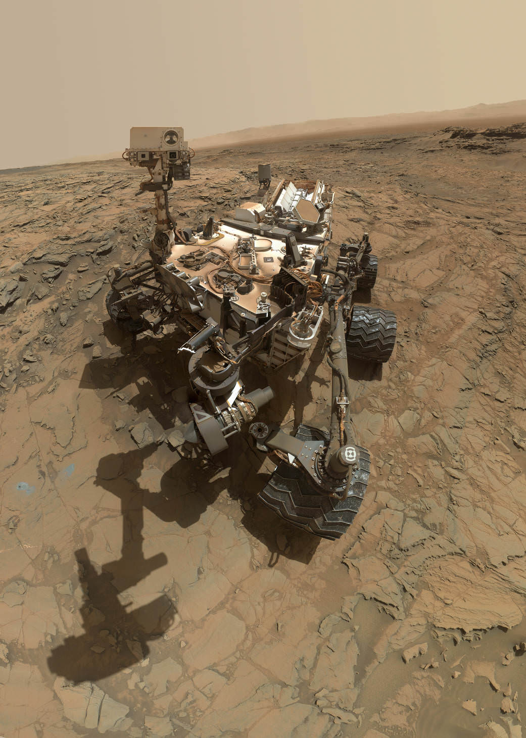
This self-portrait of NASA's Curiosity Mars rover shows the vehicle at the "Big Sky" site. Credit: NASA/JPL-Caltech/MSSS

This self-portrait of NASA’s Curiosity Mars rover shows the vehicle at the “Big Sky” site, where its drill collected the mission’s fifth taste of Mount Sharp, at lower left corner. The scene combines images taken by the Mars Hand Lens Imager (MAHLI) camera on Sol 1126 (Oct. 6, 2015). Credit: NASA/JPL-Caltech/MSSS
See below navcam drilling photo mosaic at Big Sky[/caption]

NASA’s Curiosity rover has managed to snap another gorgeous selfie while she was hard at work diligently completing her newest Martian sample drilling campaign – at the ‘Big Sky’ site at the base of Mount Sharp, the humongous mountain dominating the center of the mission’s Gale Crater landing site – which the science team just confirmed was home to a life bolstering ancient lake based on earlier sample analyses.

And the team is already actively planning for the car sized robots next drill campaign in the next few sols, or Martian days!

Overall ‘Big Sky’ marks Curiosity’s fifth ‘taste’ of Mount Sharp – since arriving at the mountain base one year ago – and eighth drilling operation since the nail biting Martian touchdown in August 2012.

NASA’s newly published self-portrait was stitched from dozens of images taken at Big Sky last week on Oct. 6, 2015, or Sol 1126, by the high resolution Mars Hand Lens Imager (MAHLI) color camera at the end of the rover’s 7 foot long robotic arm. The view is centered toward the west-northwest.

At Big Sky, the Curiosity Mars Science Laboratory (MSL) bored into an area of cross-bedded sandstone rock in the Stimson geological unit on Sept. 29, or Sol 1119. Stimson is located on the lower slopes of Mount Sharp inside Gale Crater.

NASA Curiosity rover reaches out with robotic arm to drill into cross-bedded sandstone rock at ‘Big Sky’ target on Sol 1119, Sept. 29, 2015, in this photo mosaic stitched from navcam  camera raw images and colorized.  Big Sky is located in the Stimson unit on the lower slopes of Mount Sharp inside Gale Crater.  Credit: NASA/JPL/Ken Kremer/kenkremer.com/Marco Di Lorenzo
NASA Curiosity rover reaches out with robotic arm to drill into cross-bedded sandstone rock at ‘Big Sky’ target on Sol 1119, Sept. 29, 2015, in this photo mosaic stitched from navcam camera raw images and colorized. Big Sky is located in the Stimson unit on the lower slopes of Mount Sharp inside Gale Crater. Credit: NASA/JPL/Ken Kremer/kenkremer.com/Marco Di Lorenzo

“Success! Our drill at “Big Sky” went perfectly!” wrote Ryan Anderson, a planetary scientist at the USGS Astrogeology Science Center and a member of the Curiosity ChemCam team.

The drill hole is seen at the lower left corner of the MAHLI camera selfie and appears grey along with grey colored tailing – in sharp contrast to the rust red surface. The hole itself is 0.63 inch (1.6 centimeters) in diameter.

Another panoramic view of the ‘Big Sky’ location shot from the rover’s eye perspective with the mast mounted Navcam camera, is shown in our photo mosaic view herein and created by the image processing team of Ken Kremer and Marco Di Lorenzo. The navcam mosaic was stitched from raw images taken up to Sol 1119 and colorized.

“With Big Sky, we found the ordinary sandstone rock we were looking for,” said Curiosity Project Scientist Ashwin Vasavada, in a statement.

The Big Sky drilling operation is part of a coordinated multi-step campaign to examine different types of sandstone rocks to provide geologic context.

“It also happens to be relatively near sandstone that looks as though it has been altered by fluids — likely groundwater with other dissolved chemicals. We are hoping to drill that rock next, compare the results, and understand what changes have taken place.”

Per normal operating procedures, the Big Sky sample was collected for analysis of the Martian rock’s ingredients in the rover’s two onboard laboratories – the Chemistry and Mineralogy X-Ray diffractometer (CheMin) and the Sample Analysis at Mars (SAM) instrument suite.

“We are all eagerly looking forward to the CheMin results from Big Sky to compare with our previous results from “Buckskin”! noted Anderson.

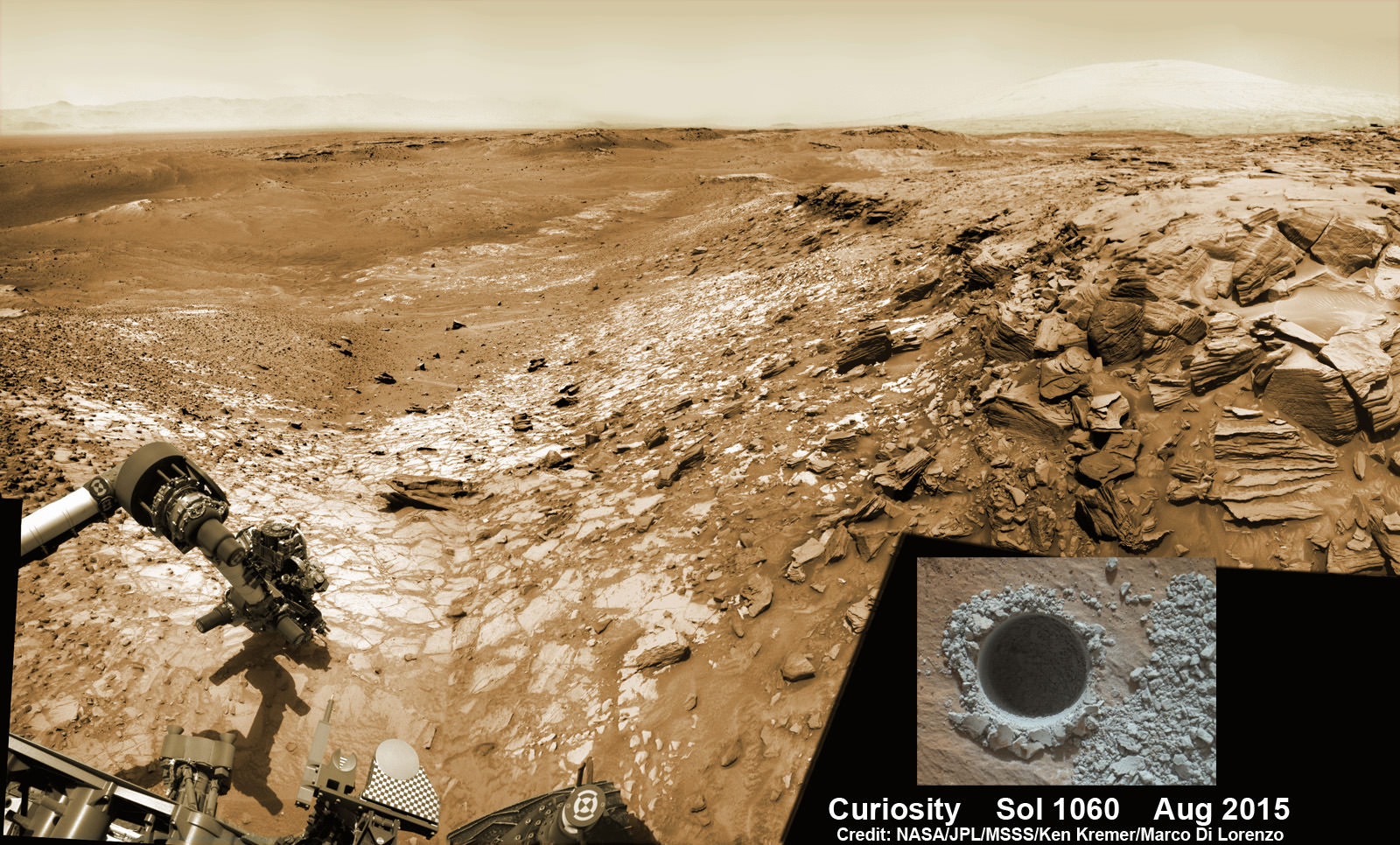
Curiosity extends robotic arm and conducts sample drilling at “Buckskin” rock target at bright toned “Lion” outcrop at the base of Mount Sharp on Mars, seen at right.   Gale Crater eroded rim seen in the distant background at left, in this composite multisol mosaic of navcam raw images taken to Sol 1059, July 30, 2015.  Navcam camera raw images stitched and colorized. Inset: MAHLI color camera up close image of full depth drill hole at “Buckskin” rock target on Sol 1060.  Credit:  NASA/JPL-Caltech/MSSS/Ken Kremer/kenkremer.com/Marco Di Lorenzo
Curiosity extends robotic arm and conducts sample drilling at “Buckskin” rock target at bright toned “Lion” outcrop at the base of Mount Sharp on Mars, seen at right. Gale Crater eroded rim seen in the distant background at left, in this composite multisol mosaic of navcam raw images taken to Sol 1059, July 30, 2015. Navcam camera raw images stitched and colorized. Inset: MAHLI color camera up close image of full depth drill hole at “Buckskin” rock target on Sol 1060. Credit: NASA/JPL-Caltech/MSSS/Ken Kremer/kenkremer.com/Marco Di Lorenzo

This past weekend, Curiosity successfully fed pulverized and sieved samples of Big Sky to the inlet ports for both CheMin and SAM on the rover deck.

“The SAM analysis of the Big Sky drill sample went well and there is no need for another analysis, so the rest of the sample will be dumped out of CHIMRA on Sol 1132,” said Ken Herkenhoff, Research Geologist at the USGS Astrogeology Science Center and an MSL science team member, in a mission update.

Concurrently the team is hard at work readying the rover for the next drill campaign within days, likely at a target dubbed “Greenhorn.”

So the six wheeled rover drove about seven meters to get within range of Greenhorn.

With the sample deliveries accomplished, attention shifted to the next drilling campaign.

Today, Wednesday, Oct. 14, or Sol 1133, Curiosity was commanded “to dump the “Big Sky” sample and “thwack” CHIMRA (the Collection and Handling for in-Situ Martian Rock Analysis) to clean out any remnants of the sample,” wrote Lauren Edgar, a Research Geologist at the USGS Astrogeology Science Center and a member of MSL science team, in a mission update.

The ChemCam and Mastcam instruments are simultaneously making observations of the “Greenhorn” and “Gallatin Pass” targets “to assess chemical variations across a fracture.”

This Martian "postcard" comes after Mars Curiosity drilled its eighth hole on the Red Planet.  This composite image looking toward the higher regions of Mount Sharp was taken on September 9, 2015, by NASA's Curiosity rover. In the foreground -- about 2 miles (3 kilometers) from the rover -- is a long ridge teeming with hematite, an iron oxide.  Credits: NASA/JPL-Caltech/MSSS
This Martian “postcard” comes after Mars Curiosity drilled its eighth hole on the Red Planet. This composite image looking toward the higher regions of Mount Sharp was taken on September 9, 2015, by NASA’s Curiosity rover. In the foreground — about 2 miles (3 kilometers) from the rover — is a long ridge teeming with hematite, an iron oxide. Credits: NASA/JPL-Caltech/MSSS

Curiosity has already accomplished her primary objective of discovering a habitable zone on the Red Planet – at the Yellowknife Bay area – that contains the minerals necessary to support microbial life in the ancient past when Mars was far wetter and warmer billions of years ago.

As of today, Sol 1133, October 14, 2015, she has driven some 6.9 miles (11.1 kilometers) kilometers and taken over 274,600 amazing images.

Stay tuned here for Ken’s continuing Earth and planetary science and human spaceflight news.
Ken Kremer

Curiosity looks toward fabulous canyons and buttes at the base of Mount Sharp from the Stimson sand dunes on Mars on Sol 1100, Sept. 10  2015 in this photo mosaic stitched from Mastcam color camera raw images.  Credit: NASA/JPL/MSSS/Ken Kremer/kenkremer.com/Marco Di Lorenzo
Curiosity looks toward fabulous canyons and buttes at the base of Mount Sharp from the Stimson sand dunes on Mars on Sol 1100, Sept. 10 2015 in this photo mosaic stitched from Mastcam color camera raw images. Credit: NASA/JPL/MSSS/Ken Kremer/kenkremer.com/Marco Di Lorenzo

‘The Martian’ is a Cinematic Triumph – Follow Mark Watney’s Trail across the Real Mars in Photos and Flyover Video

Scene from ‘The Martian’ starring Matt Damon as NASA astronaut Mark Watney contemplating magnificent panoramic vista while stranded alone on Mars. Credits: 20th Century Fox

Scene from ‘The Martian’ starring Matt Damon as NASA astronaut Mark Watney contemplating magnificent panoramic vista while stranded alone on Mars.
Credits: 20th Century Fox
See real Martian maps and flyover video from DLR and NSA below
Story/imagery updated[/caption]

Go now and experience Hollywood’s blockbuster new space epic ‘The Martian’ helmed by world renowned director Ridley Scott and starring Matt Damon as the protagonist, NASA astronaut Mark Watney. And you can follow Watney’s dramatic fictional path across the Red Planet in newly released real photos and a flyover video of the region, from DLR and NASA, as it looks today.

‘The Martian’ is a mesmerizingly enjoyable cinematic triumph for everyone that’s all about science, space exploration and one man’s struggle to survive while left totally isolated on the Red Planet in the face of seemingly insurmountable odds – relying on his wits alone to endure “on a planet where nothing grows” while hoping somehow for a rescue by NASA four years in the future.

The movie combines compelling and plausible storytelling with outstanding special effects that’s clearly delighting huge audiences worldwide with a positive and uplifting view of what could be achieved in the future – if only we really put our minds to it!

Based on the bestselling book by Andy Weir, ‘The Martian’ movie from 20th Century Fox tells the spellbinding story of how NASA astronaut Mark Watney is accidentally stranded on the surface of Mars during the future Ares 3 manned expedition in 2035, after a sudden and unexpectedly fierce dust storm forces the rest of the six person crew – commanded by Jessica Chastain as Commander Lewis – to quickly evacuate after they believe he is dead.

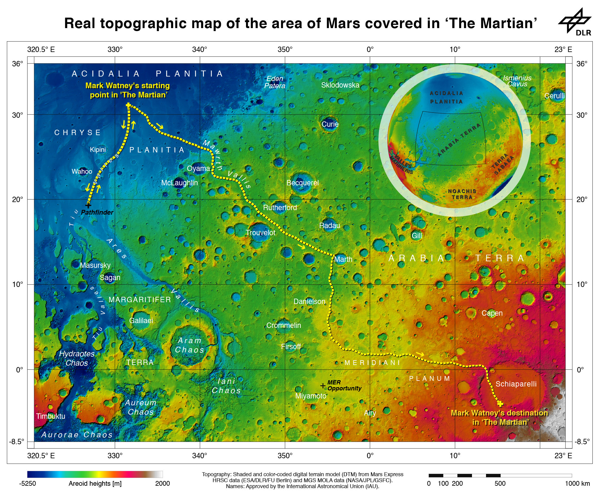
Real topographic map of the area of Mars covered in ‘The Martian.’ Follow the path of Mark Watney’s fictional endeavors from the Ares 3 landing site at Acidalia Planitia to NASA’s real Mars Pathfinder lander at the mouths of Ares Vallis and Tiu Valles and back, and finally to the Ares 4 landing site at  Schiaparelli Crater.  Credit: DLR/ESA
Real topographic map of the area of Mars covered in ‘The Martian.’ Follow the path of Mark Watney’s fictional endeavors from the Ares 3 landing site at Acidalia Planitia to NASA’s real Mars Pathfinder lander at the mouths of Ares Vallis and Tiu Valles and back, and finally to the Ares 4 landing site at Schiaparelli Crater. Credit: DLR/ESA/NASA

Now you can follow the fictional exploits of Mark Watney’s stunningly beautiful trail across the real Mars through a set of newly released maps, imagery and a 3D video created by the DLR, the German Aerospace Agency, and NASA – and based on photos taken by the European Space Agency’s Mars Express orbiter and NASA’s Mars Reconnaissance Orbiter (MRO).

DLR’s stunning 3D overflight video sequence was created from a dataset of 7300 stereo images covering roughly two-and-a-half million square kilometres of precisely mapped Martian landscape captured over the past 12 years by Mars Express High Resolution Stereo Camera (HRSC). The electric score is by Stephan Elgner.

Video Caption: Following the path of The Martian – video generated using images acquired by the Mars Express orbiter. Scientists from German Aerospace Center, DLR– who specialise in producing highly accurate topographical maps of Mars – reconstructed Watney’s route using stereo image data acquired by the High Resolution Stereo Camera on board European Space Agency’s #MarsExpress spacecraft. They then compiled this data into a video that shows the spectacular landscape that the protagonist would see ‘in the future’ on his trek from Ares 3 at Acidalia Planitia/Chryse Planitia to Ares 4 at Schiaparelli Crater. Credit: DLR/ESA

Ridley Scotts ‘The Martian’ takes place mostly on the surface of the Red Planet and is chock full of breathtakingly beautiful panoramic vistas. In the book you can only imagine Mars. In the movie Scott’s talents shine as he immerses you in all the action on the alien world of Mars from the opening scene.

Starting with the landing site for Watney’s Ares 3 mission crew at Acidalia Planitia, the book and movie follows his triumphs and tribulations, failures and successes as he logically solves one challenging problem after another – only to face increasingly daunting and unexpected hurdles as time goes by and supplies run low.

The DLR route map shows a real topographic view of Watney’s initial journey back and forth from the fictional Ares 3 landing site to the actual landing site of NASA’s 1997 Mars Pathfinder lander and Sojourner rover mission at the mouth of Ares Vallis.

People and technology from NASA's Jet Propulsion Laboratory aid fictional astronaut Mark Watney during his epic survival story in "The Martian."  Credits: 20th Century Fox
Mark Watney arrives at the NASA’s 1997 Pathfinder lander to gather communications gear in a scene from “The Martian.” People and technology from NASA’s Jet Propulsion Laboratory aid fictional astronaut Mark Watney during his epic survival story in “The Martian.” Credits: 20th Century Fox

The map continues with Watney’s months-long epic trek to the fictional landing site of Ares 4 Mars Ascent Vehicle (MAV) spacecraft at Schiaparelli Crater, by way of Marth Valles and other Martian landmarks, craters and valleys.

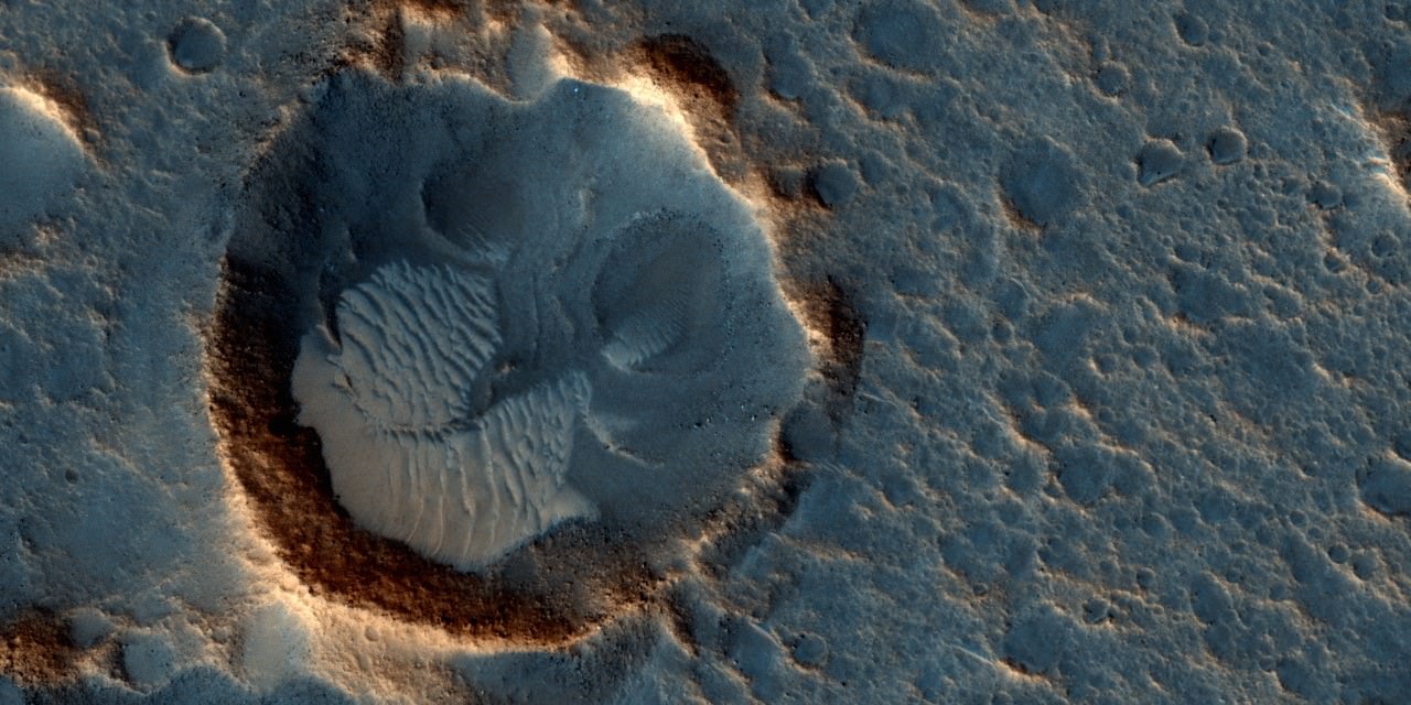
At the request of Andy Weir, the HiRISE camera on NASA’s MRO orbiter took photos of the Martian plain at the Ares 3 landing site in Acidalia Planitia, which is within driving distance from the Pathfinder lander and Sojourner rover in the book and movie.

This May 2015 image from the HiRISE camera on NASA's Mars Reconnaissance Orbiter shows a location on Mars associated with the best-selling novel and Hollywood movie, "The Martian." It is in a region called Acidalia Planitia, at the landing site for the science-fiction tale's Ares 3 mission.  For the story's central character, Acidalia Planitia is within driving distance from where NASA's Mars Pathfinder, with its Sojourner rover, landed in 1997. Credits: NASA/JPL-Caltech/Univ. of Arizona
This May 2015 image from the HiRISE camera on NASA’s Mars Reconnaissance Orbiter shows a location on Mars associated with the best-selling novel and Hollywood movie, “The Martian.” It is in a region called Acidalia Planitia, at the landing site for the science-fiction tale’s Ares 3 mission. For the story’s central character, Acidalia Planitia is within driving distance from where NASA’s Mars Pathfinder, with its Sojourner rover, landed in 1997. Credits: NASA/JPL-Caltech/Univ. of Arizona

The Martian is all about how Watney uses his botany, chemistry and engineering skills to “Science the sh** out of it” to grow food and survive until the hoped for NASA rescue.

Learning how to live off the land will be a key hurdle towards enabling NASA’s real strategy for long term space voyages on a ‘Journey to Mars’ and back.

‘The Martian’ is a must see movie that broadly appeals to space enthusiasts and general audiences alike who can easily identify with Watney’s ingenuity and will to live.

Since its worldwide premiere on Oct. 2, ‘The Martian’ has skyrocketed to the top of the US box office for the second weekend in a row, hauling in some $37.3 million. The total domestic box office receipts now top $108 million and rockets to over $228 million worldwide in the first 10 days alone.

I absolutely loved ‘The Martian’ when I first saw the movie on opening weekend. And enjoyed it even more the second time, when I could pick up a few details I missed the first time around.

Matt Damon stars as NASA astronaut Mark Watney in ‘The Martian.' Credit: 20th Century Fox
Matt Damon stars as NASA astronaut Mark Watney in ‘The Martian.’ Credit: 20th Century Fox

The movie begins as the crew evacuates after they believe Watney was killed by the dust storm. Watney actually survived the storm but lost contact with NASA. The film recounts his ingenious years long struggle to survive, figure out how to tell NASA he is alive and send a rescue crew before he starves to death on a planet where nothing grows. Watney’s predicament is a survival lesson to all including NASA.

‘The Martian’ was written by Andy Weir in 2010 and the film could well break the October movie box office record currently held by ‘Gravity.’

The movie closely follows the book, which I highly recommend you read at some point.

By necessity, the 2 hour 20 minute movie cannot capture every event in the book. So there is an abbreviated sense of Watney’s detailed science to survive and lengthy overland trips.

All the heroics and difficulties in traveling to Pathfinder and back and getting communications started, as well as the final month’s long journey to Schiaparelli crater are significantly condensed, but captured in spirit.

The Martian is brilliant and intelligent and rivals Stanley Kubrik’s space epic ‘2001: A Space Odyssey’ as one of the top movies about humanities space exploration quest.

The one big science inaccuracy takes place right at the start with the violent Martian dust storm.

On Mars the atmosphere is so thin that the winds would not be anywhere near as powerful or destructive as portrayed. This is acknowledged by Weir and done for dramatic license. We can look past that since the remainder of the tale portrays a rather realistic architectural path to Mars and vision of how scientists and engineers think. Plus the dust storms can in fact kick up tremendous amounts of particles that significantly block sunlight from impinging on solar energy generating panels.

Personally I can’t wait for the ‘Directors Cut’ with an added 30 to 60 minutes of scenes that were clearly filmed – but not included in the original theatrical release.

THE MARTIAN features a star studded cast that includes Matt Damon, Jessica Chastain, Kristen Wiig, Kate Mara, Michael Pena, Jeff Daniels, Chiwetel Ejiofor, and Donald Glover.

“NASA has endorsed “The Martian’” Jim Green, NASA’s Director of Planetary Sciences, told Universe Today. Green served as technical consultant on the film.

At NASA’s Kennedy Space Center in Florida agency scientists, astronauts actors from the 20th Century Fox Entertainment film "The Martian" met the media. Participants included, from the left, Center Director Bob Cabana, NASA's Planetary Science Division Director Jim Green, Ph.D., actress Mackenzie Davis, who portrays Mindy Park in the movie, retired NASA astronaut Nicole Stott and actor Chiwetel Ejiofor, who portrays Vincent Kapoor in "The Martian." Credit: Julian Leek
At NASA’s Kennedy Space Center in Florida agency scientists, astronauts actors from the 20th Century Fox Entertainment film “The Martian” met the media. Participants included, from the left, Center Director Bob Cabana, NASA’s Planetary Science Division Director Jim Green, Ph.D., actress Mackenzie Davis, who portrays Mindy Park in the movie, retired NASA astronaut Nicole Stott and actor Chiwetel Ejiofor, who portrays Vincent Kapoor in “The Martian.” Credit: Julian Leek

The DLR film was created by a team led by Ralf Jaumann from the DLR Institute of Planetary Research, Principal Investigator for HRSC. He believes that producing the overflight video was not just a gimmick for a science fiction film:

“Mars generates immense fascination, and our curiosity continues to grow! Many people are interested in our research, and young people in particular want to know what it is really like up there, and how realistic the idea that one day people will leave their footprints on the surface of Mars truly is. The data acquired by HRSC shows Mars with a clarity and detail unmatched by any other experiment. Only images acquired directly on the surface, for instance by rovers like Curiosity, are even closer to reality, but they can only show a small part of the planet. Thanks to this animation, we have even noticed a few new details that we had not seen in a larger spatial context. That is why we made the film – it helps everyone see what it would be like for Watney to travel through these areas… the clouds were the only creative touches we added, because, fortunately, they do not appear in the HRSC data,” according to a DLR statement.

Here’s the second official trailer for The Martian:

As a scientist and just plain Earthling, my most fervent hope is that ‘The Martian’ will inspire our young people to get interested in all fields of science, math and engineering and get motivated to become the next generation of explorers – here on Earth and beyond to the High Frontier to benefit all Mankind.

Stay tuned here for Ken’s continuing Earth and planetary science and human spaceflight news.

Ken Kremer

Movie poster for The Martian
The Martian. Image credit: 20th Century Fox

Route map in original German (Deutsch):

21962932715_702f79a908_o

Curiosity Rover Confirms Ancient Lake Filled Gale Crater, Boosting Chance of Life

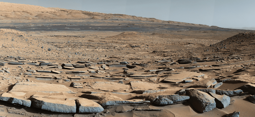
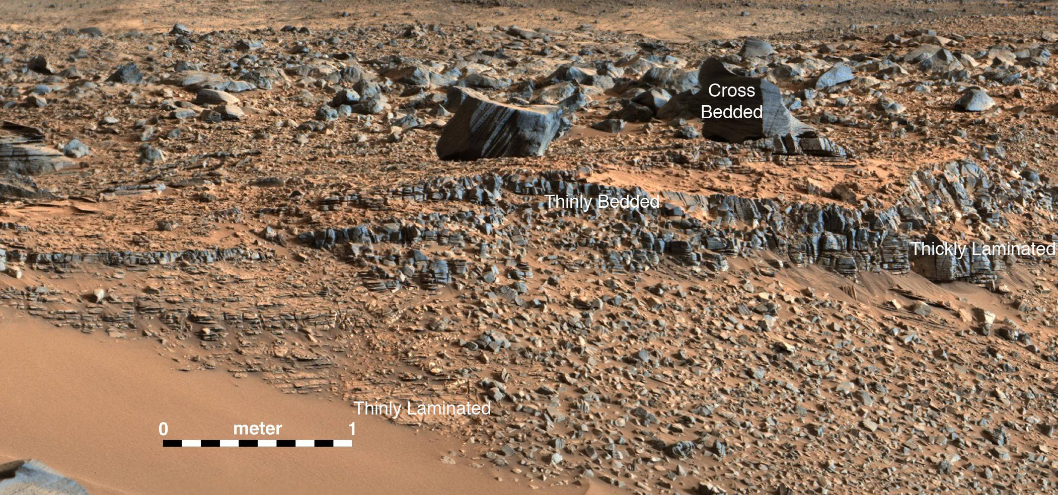
A view from the "Kimberley" formation on Mars taken by NASA's Curiosity rover. The strata in the foreground dip towards the base of Mount Sharp, indicating flow of water toward a basin that existed before the larger bulk of the mountain formed. This image was taken by the Mast Camera (Mastcam) on Curiosity on Sol 580 of the mission and has been “white balanced” to adjust for the lighting on Mars make the sky appear light blue. Credits: NASA/JPL-Caltech/MSSS

A view from the “Kimberley” formation on Mars taken by NASA’s Curiosity rover. The strata in the foreground dip towards the base of Mount Sharp, indicating flow of water toward a basin that existed before the larger bulk of the mountain formed. This image was taken by the Mast Camera (Mastcam) on Curiosity on Sol 580 of the mission and has been “white balanced” to adjust for the lighting on Mars make the sky appear light blue. Credits: NASA/JPL-Caltech/MSSS
Story/imagery updated[/caption]

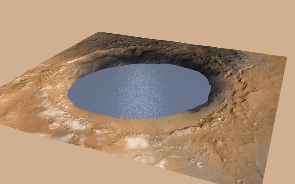
Hot on the heels of NASA’s groundbreaking announcement on Sept. 28 of the discovery that “liquid water flows intermittently” across multiple spots on the surface of today’s Mars, scientists leading NASA’s Curiosity rover mission have confirmed that an ancient lake once filled the Gale Crater site which the robot has been methodically exploring since safely landing back in August 2012 near the base of a layered mountain known as Mount Sharp.

The new research finding from the Curiosity team was just published in the journal Science on Friday, Oct. 9, and boosts the chances that alien life may have taken hold in the form of past or present day Martian microbes.

The article is titled “Wet Paleoclimate of Mars Revealed by Ancient Lakes at Gale Crater,” with John Grotzinger, the former project scientist for the Mars Science Laboratory (MSL) mission at the California Institute of Technology in Pasadena, as lead author of the new report.

Simulated view of Gale Crater Lake on Mars. This illustration depicts a lake of water partially filling Mars’ Gale Crater, receiving runoff from snow melting on the crater’s northern rim. Credit: NASA/JPL-Caltech/ESA/DLR/FU Berlin/MSSS

The new study is coauthored by four dozen team members intimately involved in Curiosity’s ongoing exploits and “confirmed that Mars was once, billions of years ago, capable of storing water in lakes over an extended period of time.”

“Observations from the rover suggest that a series of long-lived streams and lakes existed at some point between about 3.8 to 3.3 billion years ago, delivering sediment that slowly built up the lower layers of Mount Sharp,” said Ashwin Vasavada, current MSL project scientist at NASA’s Jet Propulsion Laboratory in Pasadena, California, and co-author of the new report, in a statement.

Over the past three years, the Curiosity Mars Science Laboratory rover has been traversing the floor of Gale Crater investigating scores of different rocks and outcrops with her suite of state-of-the-art instruments, and painstakingly analyzing drill samples cored from their interiors with a pair of chemistry labs to elucidate the history of Mars based on NASA’s “follow the water” mantra.

The soundness of NASA Mars exploration strategy has repeatedly borne fruit and is now validated by overwhelming measurements gathered during Curiosity’s epic Martian trek confirming the existence of a lake where Mount Sharp now stands.

Exploring the sedimentary layers of Mount Sharp, which towers 3.4 miles (5.5 kilometers) into the Martian sky, is the primary destination and goal of the rovers long term scientific expedition on the Red Planet.

Since the nail biting touchdown on Aug. 5, 2012, Curiosity has been on a path towards the sedimentary layers at the lower reaches of Mount Sharp at the center of Gale Crater.

Curiosity rover panorama of Mount Sharp captured on June 6, 2014 (Sol 651) during traverse inside Gale Crater.  Note rover wheel tracks at left.  She will eventually ascend the mountain at the ‘Murray Buttes’ at right later this year. Assembled from Mastcam color camera raw images and stitched by Marco Di Lorenzo and Ken Kremer.   Credit:   NASA/JPL/MSSS/Marco Di Lorenzo/Ken Kremer-kenkremer.com
Curiosity rover panorama of Mount Sharp captured on June 6, 2014 (Sol 651) during traverse inside Gale Crater. Note rover wheel tracks at left. She will eventually ascend the mountain at the ‘Murray Buttes’ at right later this year. Assembled from Mastcam color camera raw images and stitched by Marco Di Lorenzo and Ken Kremer. Credit: NASA/JPL/MSSS/Marco Di Lorenzo/Ken Kremer-kenkremer.com

The car sized robot arrived at the foothills of Mount Sharp a year ago in September 2014, marking the start of the mountains formal investigation.

But the origin of Mount Sharp has been up for debate.

With the new data, researchers believe that the ancient lake helped fill Gale Crater with sediments deposited in layers over time that formed the foundation for Mount Sharp which now dominates the center of the crater.

“What we thought we knew about water on Mars is constantly being put to the test,” said Michael Meyer, lead scientist for NASA’s Mars Exploration Program at NASA Headquarters in Washington.

“It’s clear that the Mars of billions of years ago more closely resembled Earth than it does today. Our challenge is to figure out how this more clement Mars was even possible, and what happened to that wetter Mars.”

Mars was far wetter and warmer and possessed a much more massive atmosphere billions of years ago than it does today.

An image taken at the "Hidden Valley" site, en-route to Mount Sharp, by NASA's Curiosity rover. A variety of mudstone strata in the area indicate a lakebed deposit, with river- and stream-related deposits nearby.  This image was taken by the Mast Camera (Mastcam) on Curiosity on Sol 703.  Credits: NASA/JPL-Caltech/MSSS
An image taken at the “Hidden Valley” site, en-route to Mount Sharp, by NASA’s Curiosity rover. A variety of mudstone strata in the area indicate a lakebed deposit, with river- and stream-related deposits nearby. This image was taken by the Mast Camera (Mastcam) on Curiosity on Sol 703. Credits: NASA/JPL-Caltech/MSSS

Gale Crater lake existed long before Mount Sharp ever formed during that period billions of years ago when the Red Planet was far warmer and wetter.

“Paradoxically, where there is a mountain today there was once a basin, and it was sometimes filled with water,” said Grotzinger, in a statement.

“We see evidence of about 250 feet (75 meters) of sedimentary fill, and based on mapping data from NASA’s Mars Reconnaissance Orbiter and images from Curiosity’s camera, it appears that the water-transported sedimentary deposition could have extended at least 500 to 650 feet (150 to 200) meters above the crater floor.”

Indeed there is additional evidence that the sedimentary deposits from interaction with water may be as thick as one-half mile (800 meters) above the crater floor. However beyond that there is no evidence of hydrated strata further up Mount Sharp.

But for reasons we are still trying to decipher and comprehend, Mars underwent radical climactic change between 3 and 4 billion years ago and was transformed from an ancient wet world, potentially hospitable to life, to a cold, dry desiccated world, rather inhospitable to life, that exists today.

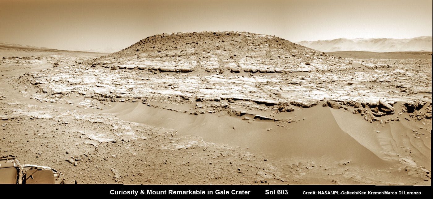
Curiosity’s Panoramic view of Mount Remarkable at ‘The Kimberley Waypoint’ where rover conducted 3rd drilling campaign inside Gale Crater on Mars. The navcam raw images were taken on Sol 603, April 17, 2014, stitched and colorized. Credit: NASA/JPL-Caltech/Ken Kremer – kenkremer.com/Marco Di Lorenzo.  Featured on APOD - Astronomy Picture of the Day on May 7, 2014
Curiosity’s Panoramic view of Mount Remarkable at ‘The Kimberley Waypoint’ where rover conducted 3rd drilling campaign inside Gale Crater on Mars. The navcam raw images were taken on Sol 603, April 17, 2014, stitched and colorized. Credit: NASA/JPL-Caltech/Ken Kremer – kenkremer.com/Marco Di Lorenzo. Featured on APOD – Astronomy Picture of the Day on May 7, 2014

Unlocking the mysteries, mechanisms and time periods of Mars climate change, loss of a thick atmosphere, ability to sustain liquid surface water and searching for organic compounds and for evidence of past or present habitable zones favorable to life are the questions driving NASA’s Mars Exploration program

Curiosity has already accomplished her primary objective of discovering a habitable zone on the Red Planet – at the Yellowknife Bay area – that contains the minerals necessary to support microbial life in the ancient past when Mars was far wetter and warmer billions of years ago.

NASA’s Curiosity rover looks back to ramp with potential 4th drill site target at ‘Bonanza King’ rock outcrop in ‘Hidden Valley’ in this photo mosaic view captured on Aug. 6, 2014, Sol 711.  Inset shows results of brushing on Aug. 17, Sol 722, that revealed gray patch beneath red dust.  Note the rover’s partial selfie, valley walls, deep wheel tracks in the sand dunes and distant rim of Gale crater beyond the ramp. Navcam camera raw images stitched and colorized.  Credit: NASA/JPL-Caltech/Ken Kremer-kenkremer.com/Marco Di Lorenzo
NASA’s Curiosity rover looks back to ramp with potential 4th drill site target at ‘Bonanza King’ rock outcrop in ‘Hidden Valley’ in this photo mosaic view captured on Aug. 6, 2014, Sol 711. Inset shows results of brushing on Aug. 17, Sol 722, that revealed gray patch beneath red dust. Note the rover’s partial selfie, valley walls, deep wheel tracks in the sand dunes and distant rim of Gale crater beyond the ramp. Navcam camera raw images stitched and colorized. Credit: NASA/JPL-Caltech/Ken Kremer-kenkremer.com/Marco Di Lorenzo

“We have tended to think of Mars as being simple,” Grotzinger mused. “We once thought of the Earth as being simple too. But the more you look into it, questions come up because you’re beginning to fathom the real complexity of what we see on Mars. This is a good time to go back to reevaluate all our assumptions. Something is missing somewhere.”

Curiosity recently celebrated 1000 Sols of exploration on Mars on May 31, 2015 – detailed here with our Sol 1000 mosaic by Marco Di Lorenzo and Ken Kremer also featured at Astronomy Picture of the Day on June 13, 2015.

As of today, Sol 1129, October 10, 2015, she has driven some 6.9 miles (11.1 kilometers) kilometers and taken over 274,000 amazing images.

Curiosity is at the vanguard of Earth’s fleet of seven robotic missions paving the path for NASA’s plans to send humans on a ‘Journey to Mars’ in the 2030s.

Stay tuned here for Ken’s continuing Earth and planetary science and human spaceflight news.

Ken Kremer

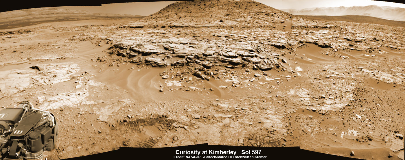
Curiosity Mars rover captured this panoramic view of a butte called "Mount Remarkable" and surrounding outcrops at “The Kimberley " waypoint on April 11, 2014, Sol 597. Colorized navcam photomosaic was stitched by Marco Di Lorenzo and Ken Kremer.  Credit: NASA/JPL-Caltech/Marco Di Lorenzo/Ken Kremer - kenkremer.com
Curiosity Mars rover captured this panoramic view of a butte called “Mount Remarkable” and surrounding outcrops at “The Kimberley ” waypoint on April 11, 2014, Sol 597. Colorized navcam photomosaic was stitched by Marco Di Lorenzo and Ken Kremer. Credit: NASA/JPL-Caltech/Marco Di Lorenzo/Ken Kremer – kenkremer.com

Awesome Blue Skies and Red Surface Ice Found at Pluto – The Other Red Planet

Pluto’s Blue Sky: Pluto’s haze layer shows its blue color in this picture taken by the New Horizons Ralph/Multispectral Visible Imaging Camera (MVIC). The high-altitude haze is thought to be similar in nature to that seen at Saturn’s moon Titan. The source of both hazes likely involves sunlight-initiated chemical reactions of nitrogen and methane, leading to relatively small, soot-like particles (called tholins) that grow as they settle toward the surface. Credits: NASA/JHUAPL/SwRI

Much to the amazement and delight of scientists, the latest findings about Pluto reveal it possesses hazy blue skies and numerous red colored patches of water ice exposed on the surface of a world also now known as “The Other Red Planet.”

With each passing day, significant discoveries about Pluto continue piling up higher and higher as more and more data gathered and stored from this past summer’s historic flyby by NASA’s New Horizons reaches ground stations back here on Earth.

“Blue skies–Pluto is awesome!” says Alan Stern, New Horizons principal investigator from Southwest Research Institute (SwRI), Boulder, Colorado.

The bluish tint to Pluto’s skies were unexpectedly discovered after researchers examined the first color images of the high altitude atmospheric hazes returned by New Horizons last week that were taken by the probes Ralph/Multispectral Visible Imaging Camera (MVIC).

“Who would have expected a blue sky in the Kuiper Belt?” Stern said in a NASA statement.

During New Horizons flyby on July 14, 2015, it discovered that Pluto is the biggest object in the outer solar system and thus the ‘King of the Kuiper Belt.”

The Kuiper Belt comprises the third and outermost region of worlds in our solar system.

“It’s gorgeous!” exclaims Stern.

Moreover, the source of Pluto’s blue haze is different from Earth’s and more related to Titan, Saturn’s largest moon – currently being explored by NASA’s Cassini mission orbiting Saturn since 2004.

On Earth, the blue sky is caused by light scattering off tiny particles of nitrogen molecules. Whereas on Titan its related to soot-like particles called tholins.

Tholins are generated by a series of very complex sunlight-initiated chemical reactions between nitrogen and methane (CH4) high in the atmosphere. This eventually produces relatively small, soot-like particles of complex hydrocarbons.

“That striking blue tint tells us about the size and composition of the haze particles,” said New Horizons science team researcher Carly Howett, of SwRI, in a statement.

“A blue sky often results from scattering of sunlight by very small particles. On Earth, those particles are very tiny nitrogen molecules. On Pluto they appear to be larger — but still relatively small — soot-like particles we call tholins.”

As the tholins rain down on Pluto, they add to the widespread red surface coloring.

The Ralph instrument was also key in another discovery announced by New Horizons researchers.

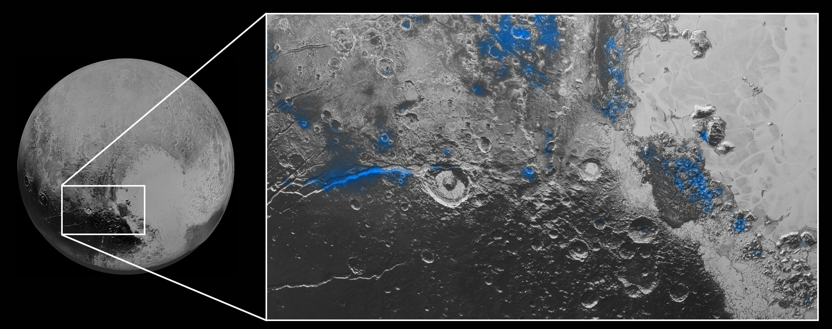
Numerous small, exposed regions of water ice on Pluto’s surface were discovered by combining measurements from the Ralph MVIC spectral composition mapper and infrared spectroscopy from the Linear Etalon Imaging Spectral Array (LEISA) instrument.

The strongest signatures of water ice were found in the Virgil Fossa and Viking Terra regions berby the western edge of Pluto’s huge heart-shaped Tombaugh Regio feature – see image below.

Water Ice on Pluto: Regions with exposed water ice are highlighted in blue in this composite image from New Horizons' Ralph instrument, combining visible imagery from the Multispectral Visible Imaging Camera (MVIC) with infrared spectroscopy from the Linear Etalon Imaging Spectral Array (LEISA). The strongest signatures of water ice occur along Virgil Fossa, just west of Elliot crater on the left side of the inset image, and also in Viking Terra near the top of the frame. A major outcrop also occurs in Baré Montes towards the right of the image, along with numerous much smaller outcrops, mostly associated with impact craters and valleys between mountains. The scene is approximately 280 miles (450 kilometers) across. Note that all surface feature names are informal.  Credits: NASA/JHUAPL/SwRI
Water Ice on Pluto: Regions with exposed water ice are highlighted in blue in this composite image from New Horizons’ Ralph instrument, combining visible imagery from the Multispectral Visible Imaging Camera (MVIC) with infrared spectroscopy from the Linear Etalon Imaging Spectral Array (LEISA). The strongest signatures of water ice occur along Virgil Fossa, just west of Elliot crater on the left side of the inset image, and also in Viking Terra near the top of the frame. A major outcrop also occurs in Baré Montes towards the right of the image, along with numerous much smaller outcrops, mostly associated with impact craters and valleys between mountains. The scene is approximately 280 miles (450 kilometers) across. Note that all surface feature names are informal. Credits: NASA/JHUAPL/SwRI

Water ice is only found in certain zones of Pluto for reasons yet to be understood. There may also be a relationship to the tholins, that likewise is yet to be gleaned.

“I’m surprised that this water ice is so red,” says Silvia Protopapa, a science team member from the University of Maryland, College Park. “We don’t yet understand the relationship between water ice and the reddish tholin colorants on Pluto’s surface.”

This new global mosaic view of Pluto was created from the latest high-resolution images to be downlinked from NASA’s New Horizons spacecraft and released on Sept. 11, 2015.   The images were taken as New Horizons flew past Pluto on July 14, 2015, from a distance of 50,000 miles (80,000 kilometers).  This new mosaic was stitched from over two dozen raw images captured by the LORRI imager and colorized.  Annotated with informal place names.  Credits: NASA/Johns Hopkins University Applied Physics Laboratory/Southwest Research Institute/Marco Di Lorenzo/Ken Kremer/kenkremer.com
This new global mosaic view of Pluto was created from the latest high-resolution images to be downlinked from NASA’s New Horizons spacecraft and released on Sept. 11, 2015. The images were taken as New Horizons flew past Pluto on July 14, 2015, from a distance of 50,000 miles (80,000 kilometers). This new mosaic was stitched from over two dozen raw images captured by the LORRI imager and colorized. Annotated with informal place names. Credits: NASA/Johns Hopkins University Applied Physics Laboratory/Southwest Research Institute/Marco Di Lorenzo/Ken Kremer/kenkremer.com

As of today, New Horizons remains healthy and is over 3.1 billion miles (5 billion kilometers) from Earth.

The team hopes to fire up the thrusters later this fall to propel the spacecraft toward a second Kuiper Belt Object (KBO) in 2019 tentativley named PT1, for Potential Target 1. It is much smaller than Pluto and was recently selected based on images taken by NASA’s Hubble Space Telescope.

Stay tuned here for Ken’s continuing Earth and planetary science and human spaceflight news.

Ken Kremer