If you’re going to be in the Austin area on October 16/17, and you’re into space exploration, you’re going to want to check out the 2015 New World’s Conference.
Here’s a list of their speakers:
Richard Garriott – Private Astronaut, Entrepreneur, Video Game Industry Mogul
Jeff Greason – Co-Founder and Chairman of the Board of XCOR Aerospace
Bill Bruner – Civil/Commercial Space Manager at Lawrence Livermore National Laboratory
Tom Markusic – Founder, Firefly Space Systems
Robyn Gatens – NASA Deputy Manager, International Space Station
Jason Kessler – NASA Manager, Grand Challenges
Daniel Faber – CEO, Deep Space Industries (asteroid mining company)
Dr. John Mankins – World’s leading expert on space solar power
Dr. Jim Logan – Former NASA MD expert on space mergency medicine
Dr. John Lewis – Author – Mining the Sky
Rick Tumlinson – Founder, New Worlds, Space Frontier Foundation
John Adams – University of Arizona, Biosphere 2
Pat Rawlings – World famous space artist
In addition to the speakers, they’re going to have a few fun activities, like a live performance by ArcAttack – Tesla Coil Musicians. I’ve seen them in person and they are awesome. 🙂
There are still tickets available, and if you sign up this week, you can get 50% off the entrance price. Click here, sign up and use the code NWAUSTIN50 before the end of October 10th, 2015.
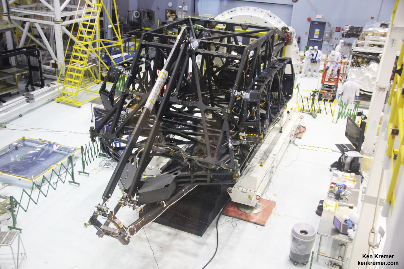
View showing actual flight structure of mirror backplane unit for NASA's James Webb Space Telescope (JWST) that holds 18 segment primary mirror array and secondary mirror mount at front, in stowed-for-launch configuration. JWST is being assembled here by technicians inside the world’s largest cleanroom at NASA Goddard Space Flight Center, Greenbelt, Md. Credit: Ken Kremer/kenkremer.com
View showing actual flight structure of mirror backplane unit for NASA’s James Webb Space Telescope (JWST) that holds 18 segment primary mirror array and secondary mirror mount at front, in stowed-for-launch configuration. JWST is being assembled here by technicians inside the world’s largest cleanroom at NASA Goddard Space Flight Center, Greenbelt, Md. Credit: Ken Kremer/kenkremer.com
Story/imagery updated[/caption]
NASA GODDARD SPACE FLIGHT CENTER, MD – The construction pace for NASA’s James Webb Space Telescope (JWST) took a major leap forward with delivery of the actual flight structure that serves as the observatory’s critical mirror holding backbone – to NASA’s Goddard Space Flight Center in Greenbelt, Maryland and observed by Universe Today.
“We are in good shape with the James Webb Space Telescope,” said Dr. John Mather, NASA’s Nobel Prize Winning scientist, in an exclusive interview with Universe Today at NASA Goddard during a visit to the flight structure – shown in my photos herein. Note: Read an Italian language version of this story – here at Alive Universe
And the mammoth $8.6 Billion Webb telescope has mammoth scientific objectives as the scientific successor to NASA’s Hubble Space Telescope (HST) – now celebrating its 25th anniversary in Earth orbit.
“JWST has the capability to look back towards the very first objects that formed after the Big Bang,” Mather told Universe Today.
How is that possible?
“James Webb has a much bigger mirror than Hubble. So its resolution is much better,” said astronaut and NASA science chief John Grunsfeld, during an exclusive interview at NASA Goddard. Grunsfeld flew on a trio of Hubble servicing missions aboard the Space Shuttle, including the final one during STS-125 in 2009.
“JWST can look back further in time, and a greater distance than Hubble, so we can see those first stars and galaxies formed in the Universe.”
These discoveries are only possible with Webb, which will become the most powerful telescope ever sent to space when it launches in 2018.
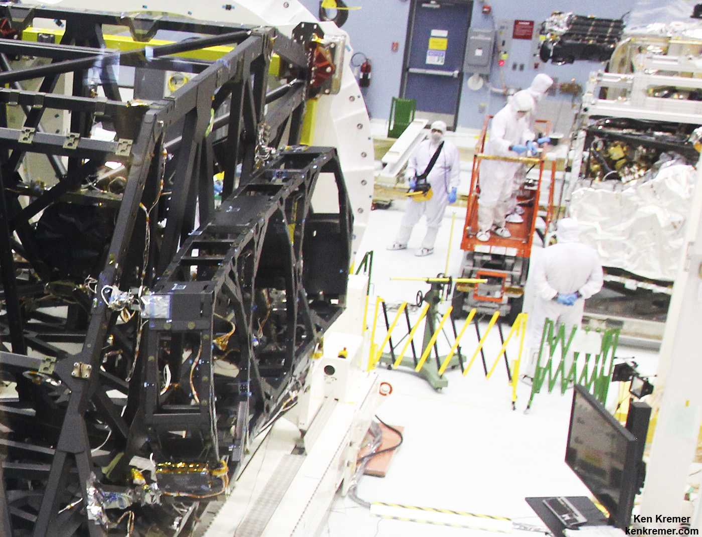
Up close view of actual side wing backplane of NASA’s James Webb Space Telescope (JWST) that will hold 3 of the observatory’s 18 primary mirrors, as technicians work inside cleanroom at NASA Goddard Space Flight Center, Greenbelt, Md. Credit: Ken Kremer/kenkremer.com
The massive JWST flight structure unit includes the “backplane assembly” that clasps in place all of the telescopes primary and secondary mirrors, as well as its ISIM science module loaded with the observatory’s quartet of state-of-the-art research instruments.
“The backplane looks really great,” Grunsfeld told me.
Numerous NASA centers and aerospace companies are involved in building the observatory and its backplane structure holding the mirrors that will search back some 13.4 billion years.
“The backplane structure just arrived in late August from Northrop Grumman Aerospace Systems in Redondo Beach, California,” said Sandra Irish, JWST lead structural engineer during an interview with Universe Today at the NASA Goddard cleanroom facility.
“This is the actual flight hardware.”
Side view of flight unit mirror backplane assembly structure for NASA’s James Webb Space Telescope (JWST) that holds primary mirror array and secondary mirror mount in stowed-for-launch configuration. JWST is being assembled technicians inside the cleanroom at NASA Goddard Space Flight Center, Greenbelt, Md. Credit: Ken Kremer/kenkremer.com
The purpose of JWST’s backplane assembly is to hold the telescopes 18 segment, 21-foot (6.5-meter) diameter primary mirror nearly motionless while floating in the utterly frigid space environment, thereby enabling the observatory to peer out into deep space for precise science gathering measurements never before possible.
The massive telescope structure “includes the primary mirror backplane assembly; the main backplane support fixture; and the deployable tower structure that lifts the telescope off of the spacecraft. The three arms at the top come together into a ring where the secondary mirror will reside,” say officials.
The backplane traveled a long and winding road before arriving at Goddard.
“The backplane structure was designed and built at Orbital ATK with NASA oversight,” Irish explained. The assembly work was done at the firms facilities in Magna, Utah.
“Then it was sent to Northrop Grumman in Redondo Beach, California for static testing. Then it came here to Goddard. Orbital ATK also built the composite tubes for the ISIM science module structure.”
The observatory’s complete flight structure measures about 26 feet (nearly 8 meters) from its base to the tip of the tripod arms and mirror mount holding the round secondary mirror.
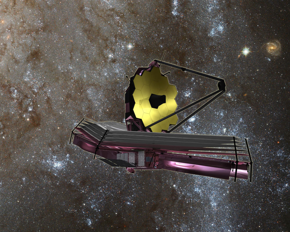
Artist’s concept of the James Webb Space Telescope (JWST) with Sunshield at bottom. Credit: NASA/ESA
The flight structure and backplane assembly arrived at Goddard in its stowed-for-launch configuration after being flown cross country from California.
“It is here for the installation of all the mirrors to build up the entire telescope assembly here at Goddard. It will be fully tested here before it is delivered to the Johnson Space Center in Houston and then back to California,” Irish elaborated.
The overall assembly is currently attached to a pair of large yellow and white fixtures that firmly secure the flight unit, to stand it upright and rotate as needed, as it undergoes acceptance testing by engineers and technicians before commencement of the next big step – the crucial mirror installation that starts soon inside the world’s largest cleanroom at NASA Goddard.
Overhead cranes are also used to maneuver the observatory structure as engineers inspect and test the unit.
But several weeks of preparatory work are in progress before the painstakingly precise mirror installation can begin under the most pristine cleanroom operating conditions.
“Right now the technicians are installing harnesses that we need to mount all over the structure,” Irish told me.
“These harnesses will go to our electronic systems and the mirrors in order to monitor their actuation on orbit. So that’s done first.”
What is the construction sequence at Goddard for the installation of the mirrors and science instruments and what comes next?
“This fall we will be installing every mirror, starting around late October/early November. Then next April 2016 we will install the ISIM science module inside the backplane structure.”
“The ISIM mounts all four of the telescope science instrument. So the mirrors go on first, then the ISIM gets installed and then it will really be the telescope structure.” ISIM carries some 7,500 pounds (2400 kg) of telescope optics and instruments.
“Then starting about next July/August 2016 we start the environmental testing.”
The actual flight mirror backplane is comprised of three segments – the main central segment and a pair of outer wing-like parts holding three mirrors each. They will be unfolded from the stowed-for-launch configuration to the “deployed” configuration to carry out the mirror installation. Then be folded back over into launch configuration for eventual placement inside the payload fairing of the Ariane V ECA booster rocket.
The telescope will launch from the Guiana Space Center in Kourou, French Guiana in 2018.
Gold coated flight spare of a JWST primary mirror segment made of beryllium and used for test operations inside the NASA Goddard clean room. Credit: Ken Kremer- kenkremer.com
The telescopes primary and secondary flight mirrors have already arrived at Goddard.
The mirrors must remained precisely aligned and nearly motionless in order for JWST to successfully carry out science investigations. While operating at extraordinarily cold temperatures between -406 and -343 degrees Fahrenheit the backplane must not move more than 38 nanometers, approximately 1/1,000 the diameter of a human hair.
To account for the tiniest of errors and enhance science, each of the primary mirrors is equipped with actuators for minute adjustments.
“A beautiful advantage of Webb that’s different from Hubble is the fact that we do have actuation [capability] of every single one of our mirrors. So if we are off by just a little bit on either our calculations or from misalignment from launch or the zero gravity release, we can do some fine adjustments on orbit.”
“We can adjust every mirror within 50 nanometers.”
“That’s important because we can’t send astronauts to fix our telescope. We just can’t.”
“The telescope is a million miles away.”
NASA’s team at Goddard has already practiced mirror installation because there are no second chances.
“We only have one shot to get this right!” Irish emphasized.
Watch for more on the mirror installation in my upcoming story.
JWST is the successor to the 25 year old Hubble Space Telescope and will become the most powerful telescope ever sent to space.
Webb is designed to look at the first light of the Universe and will be able to peer back in time to when the first stars and first galaxies were forming.
The Webb Telescope is a joint international collaborative project between NASA, the European Space Agency (ESA) and the Canadian Space Agency (CSA).
NASA has overall responsibility and Northrop Grumman is the prime contractor for JWST.
“The telescope is on schedule for its launch in 2018 in October,” Mather told me.
And the payoff from JWST will be monumental!
“On everything from nearby planets to the most distant universe, James Webb will transform our view of the Universe,” Grunsfeld beams.
Watch for more on JWST construction and mirror installation in part 2 soon.
Stay tuned here for Ken’s continuing Earth and Planetary science and human spaceflight news.
A comparison of the primary mirror used by Hubble and the primary mirror array used by the James Webb Space Telescope. Photo Credit: NASANASA Science chief and astronaut John Grunsfeld discusses James Webb Space Telescope project at NASA Goddard Space Flight Center in Maryland. Credit: Ken Kremer/kenkremer.com
Hurricane Joaquin captured on Oct. 2, 2015 by NASA Astronaut Scott Kelly from the International Space Station. Credit: NASA/Scott Kelly
As the powerful category 4 Hurricane Joaquin was pounding the Bahamas and packing winds of over 130 mph, NASA astronaut Scott Kelly captured a stunning photo of Joaquin on Friday morning, Oct. 2 from his perch aboard the International Space Station (ISS). As of today, Oct. 3. Joaquin has gained strength to 150 mph and is a borderline Cat 5 storm!
Kelly’s spectacular storm photo shows the eye of Hurricane Joaquin over the Caribbean and off the US eastern seaboard with the limb of the Earth and our atmosphere in beautiful detail.
Huge thunderstorms can been off to the north of the immense category 4 storm.
And as of today, Saturday, Oct. 3, Hurricane Joaquin has further strengthened and is now packing maximum sustained winds of 150 MPH or 240 KM/H, according to the latest advisory issued by the National Hurricane Center (NHC) as of 5 p.m. EDT.
Kelly posted the Oct. 2 photo of Joaquin with this caption on his twitter account:
“Early morning shot of Hurricane #Joaquin from @space_station before reaching #Bahamas. Hope all is safe. #YearInSpace.”
Two of the stations solar panels are seen in the photo as well as portions of the US east coast including Florida.
The latest NHC forecast shows Joaquin veering away from the US East Coast. But it’s still creating hurricane force winds and high waves that is threatening Bermuda.
“SEVERE HURRICANE JOAQUIN THREATENING BERMUDA,” said the NHC today.
It is moving northeast at 45 degrees at 17 MPH or 28 KM/H.
Kelly snapped another telling view of Joaquin on Thursday, Oct. 1 showing the Bahamas and Miami in the field of view.
Kelly tweeted; “#HurricaneJoaquin churns over the #Bahamas with #Miami in the field of view from @Space_Station.”
#HurricaneJoaquin churns over the #Bahamas with #Miami in the field of view from @Space_Station #YearInSpace. Credit: NASA/Scott Kelly
Scott Kelly is a member of the first ever 1 year ISS mission crew comprising Kelly and Russian cosmonaut Mikhail Kornienko.
They arrived at the ISS in March and had just reached the midpoint of their nearly 12 month stay aimed at conducting research to explore the impact of long term stays in space on the human body and aid NASA’s long term plans for a human‘Journey to Mars’ in the 2030s.
NASA and NOAA satellites are keeping constant watch on the progress of the powerful Hurricane Joaquin, that earlier had the potential to barrel towards tens of millions of US coastal residents.
Here’s another stunning view of Hurricane Joaquin taken by the GOES-West satellite on Oct. 1.
This stunning image of Hurricane Joaquin is from NOAA’s GOES West satellite on Oct. 1 2015. Many portions of the eastern U.S. are currently experiencing heavy rains and gusty winds associated with a frontal system. Credit: NOAA
This visible image from NASA’s Aqua satellite shows Hurricane Joaquin over Bahamas on Oct. 1.
NASA’s Aqua satellite captured this visible image of Hurricane Joaquin over Bahamas on Oct. 1 at 17:55 UTC (1:55 p.m. EDT). Credits: NASA Goddard MODIS Rapid Response Team
Stay tuned here for Ken’s continuing Earth and planetary science and human spaceflight news.
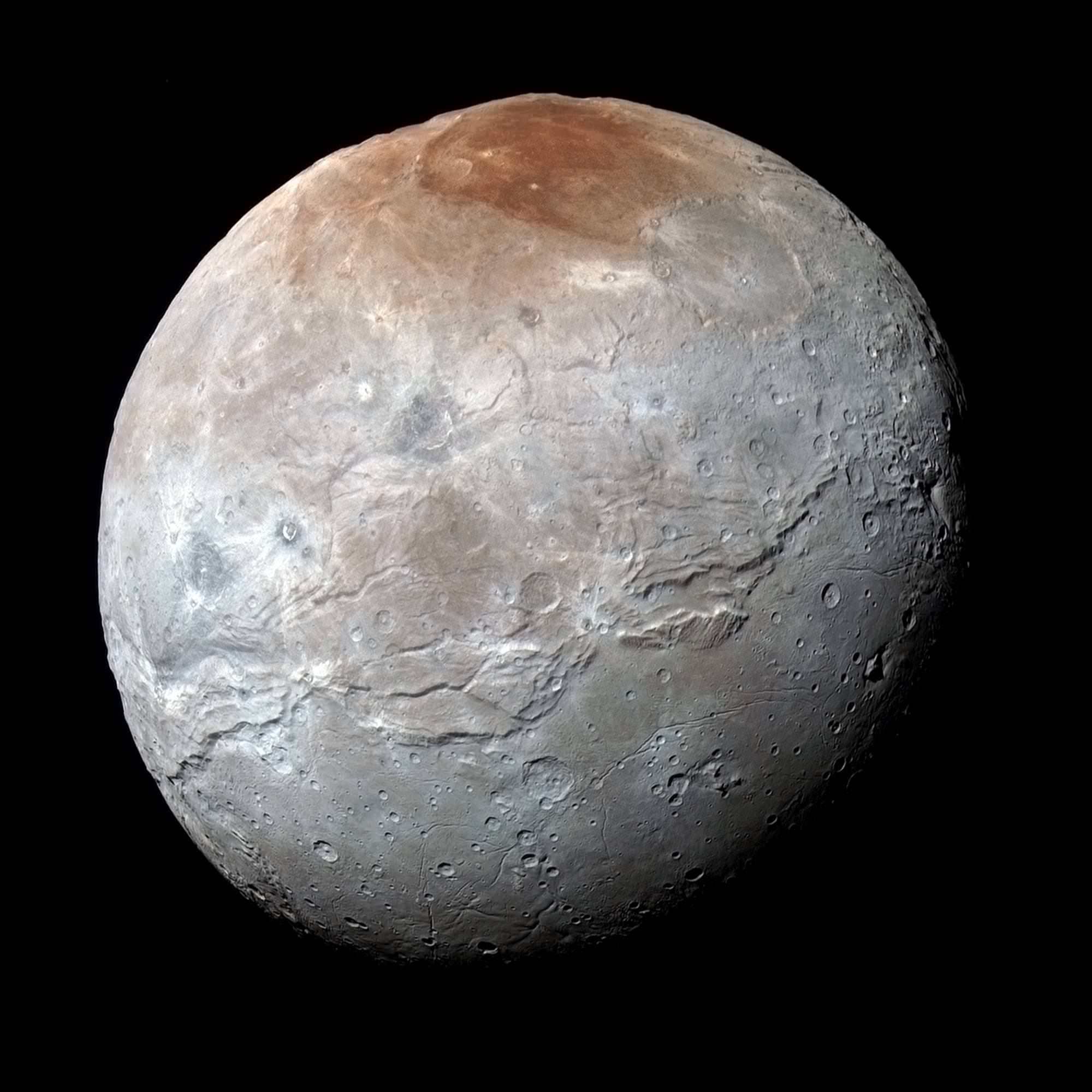
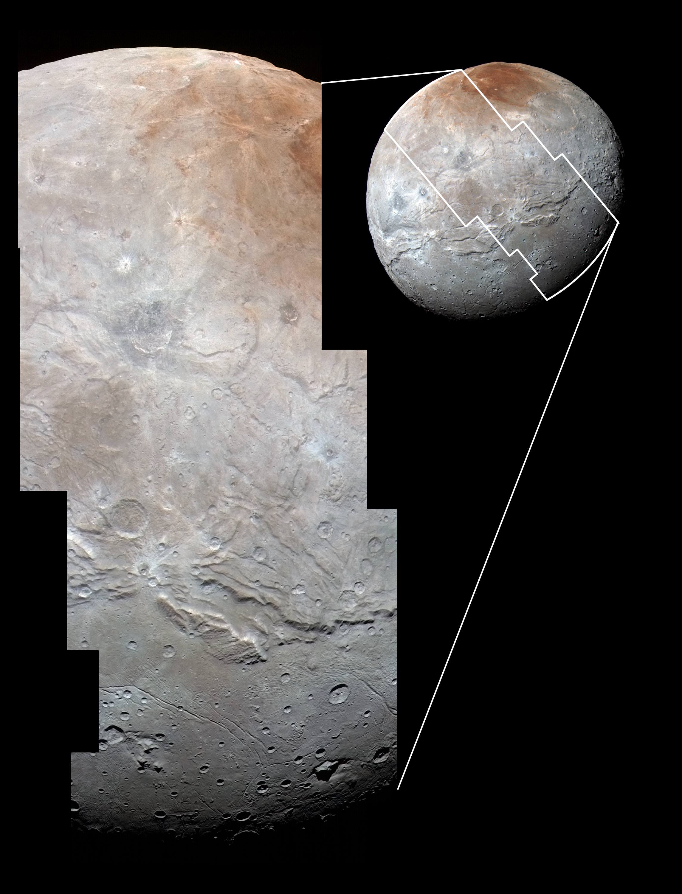
Charon in Enhanced Color. NASA's New Horizons captured this high-resolution enhanced color view of Charon just before closest approach on July 14, 2015. The image combines blue, red and infrared images taken by the spacecraft’s Ralph/Multispectral Visual Imaging Camera (MVIC); the colors are processed to best highlight the variation of surface properties across Charon. Charon’s color palette is not as diverse as Pluto’s; most striking is the reddish north (top) polar region, informally named Mordor Macula. Charon is 754 miles (1,214 kilometers) across; this image resolves details as small as 1.8 miles (2.9 kilometers). Credits: NASA/JHUAPL/SwRI
Charon in Enhanced Color with Grand Canyon
NASA’s New Horizons captured this high-resolution enhanced color view of Charon and its Grand Canyon just before closest approach on July 14, 2015. The image combines blue, red and infrared images taken by the spacecraft’s Ralph/Multispectral Visual Imaging Camera (MVIC); the colors are processed to best highlight the variation of surface properties across Charon. Charon’s color palette is not as diverse as Pluto’s; most striking is the reddish north (top) polar region, informally named Mordor Macula. Charon is 754 miles (1,214 kilometers) across; this image resolves details as small as 1.8 miles (2.9 kilometers). Credits: NASA/JHUAPL/SwRI[/caption]
Charon suffered such a surprisingly violent past of titanic upheavals that they created a humongous canyon stretching across the entire face of Pluto’s largest moon – as revealed in a fresh batch of images just returned from NASA’s New Horizons spacecraft.
We have been agog in amazement these past few weeks as New Horizons focused its attention on transmitting astounding high resolution imagery and data of Pluto, captured during mankind’s history making first encounter with our solar systems last unexplored planet on July 14, 2015, at a distance of 7,750 miles (12,500 kilometers).
“You’ll love this,” said New Horizons Principal Investigator Alan Stern of the Southwest Research Institute, Boulder, Colorado, in a blog posting.
Indeed researches say Charon’s tortured landscape of otherworldly canyons, mountains and more far exceeds scientists preconceived notions of a “monotonous, crater-battered world; instead, they’re finding a landscape covered with mountains, canyons, landslides, surface-color variations and more.”
“We thought the probability of seeing such interesting features on this satellite of a world at the far edge of our solar system was low,” said Ross Beyer, an affiliate of the New Horizons Geology, Geophysics and Imaging (GGI) team from the SETI Institute and NASA Ames Research Center in Mountain View, California, in a statement.
“But I couldn’t be more delighted with what we see.”
Measuring 754 miles (1,214 kilometers) across, Charon is half the diameter of Pluto and forms a double planet system. Charon also ranks as the largest satellite relative to its planet in the solar system. By comparison, Earth’s moon is one quarter the size of our home planet.
The new images of the Pluto-facing hemisphere of Charon were taken by New Horizons’ Long Range Reconnaissance Imager (LORRI) and the Ralph/Multispectral Visual Imaging Camera (MVIC) during the July 14 flyby and downlinked over about the past week and a half.
They reveal details of a belt of fractures and canyons just north of the moon’s equator.
High-resolution images of Charon were taken by the Long Range Reconnaissance Imager on NASA’s New Horizons spacecraft, shortly before closest approach on July 14, 2015, and overlaid with enhanced color from the Ralph/Multispectral Visual Imaging Camera (MVIC). Charon’s cratered uplands at the top are broken by series of canyons, and replaced on the bottom by the rolling plains of the informally named Vulcan Planum. The scene covers Charon’s width of 754 miles (1,214 kilometers) and resolves details as small as 0.5 miles (0.8 kilometers). Credits: NASA/JHUAPL/SwRI
The “Grand Canyon of Charon” stretches more than 1,000 miles (1,600 kilometers) across the entire face of Charon visible in the new images. Furthermore the deep canyon probably extends onto the far side of Pluto and hearkens back to Valles Marineris on Mars.
“It looks like the entire crust of Charon has been split open,” said John Spencer, deputy lead for GGI at the Southwest Research Institute in Boulder, Colorado, in a statement.
“With respect to its size relative to Charon, this feature is much like the vast Valles Marineris canyon system on Mars.”
Charon’s “Grand Canyon” is four times as long as the Grand Canyon of the United States. Plus its twice as deep in places. “These faults and canyons indicate a titanic geological upheaval in Charon’s past,” according to the New Horizons team.
This composite of enhanced color images of Pluto (lower right) and Charon (upper left), was taken by NASA’s New Horizons spacecraft as it passed through the Pluto system on July 14, 2015. This image highlights the striking differences between Pluto and Charon. The color and brightness of both Pluto and Charon have been processed identically to allow direct comparison of their surface properties, and to highlight the similarity between Charon’s polar red terrain and Pluto’s equatorial red terrain. Pluto and Charon are shown with approximately correct relative sizes, but their true separation is not to scale. The image combines blue, red and infrared images taken by the spacecraft’s Ralph/Multispectral Visual Imaging Camera (MVIC). Credits: NASA/JHUAPL/SwRI
Another intriguing finding is the area south of the canyon is much smoother, with fewer craters and may have been resurfaced by a type of “cryovolcanism.”
The southern plains are informally named “Vulcan Planum” and may be much younger.
“The team is discussing the possibility that an internal water ocean could have frozen long ago, and the resulting volume change could have led to Charon cracking open, allowing water-based lavas to reach the surface at that time,” said Paul Schenk, a New Horizons team member from the Lunar and Planetary Institute in Houston.
The piano shaped probe gathered about 50 gigabits of data as it hurtled past Pluto, its largest moon Charon and four smaller moons.
Barely 5 or 6 percent of the 50 gigabits of data captured by New Horizons has been received by ground stations back on Earth due to the slow downlink rate.
Stern says it will take about a year for all the data to get back. Many astounding discoveries await.
“I predict Charon’s story will become even more amazing!” said mission Project Scientist Hal Weaver, of the Johns Hopkins University Applied Physics Laboratory in Laurel, Maryland.
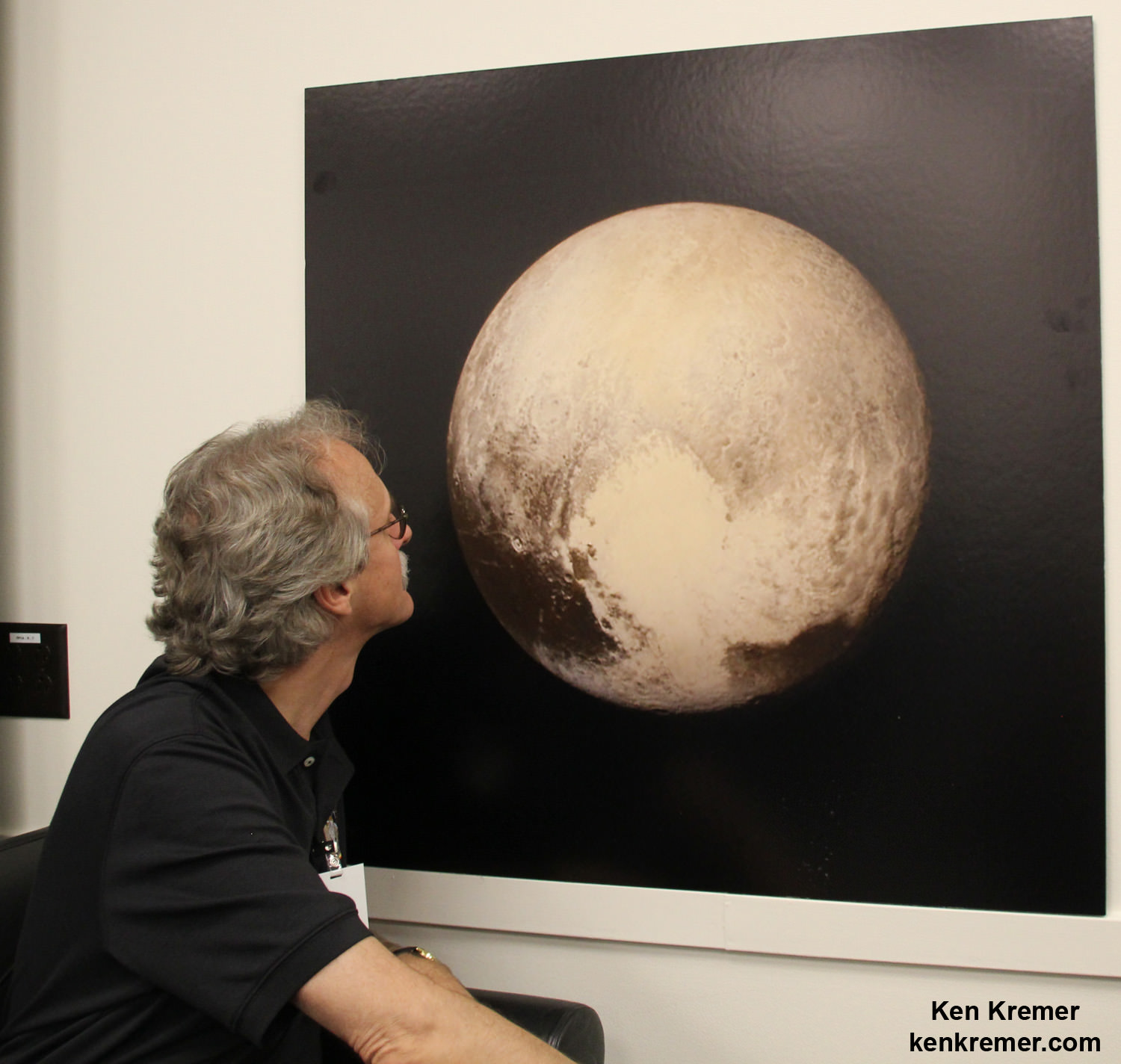
New Horizons science team co-investigator John Spencer examines print of the newest Pluto image taken on July 13, 2015 after the successful Pluto flyby. Credit: Ken Kremer/kenkremer.com
Stay tuned here for Ken’s continuing Earth and planetary science and human spaceflight news.
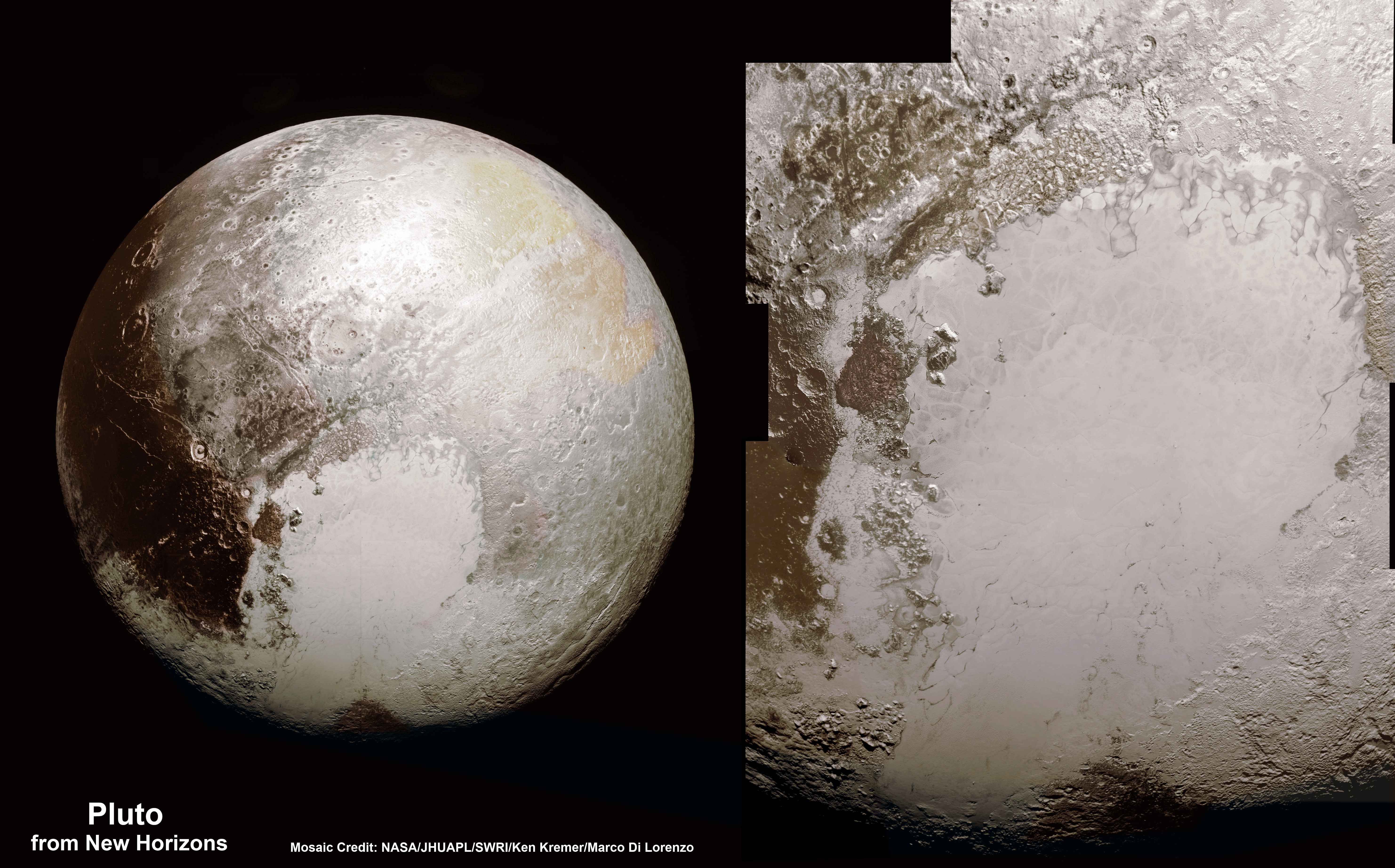
This new global mosaic view of Pluto was created from the latest high-resolution images to be downlinked from NASA’s New Horizons spacecraft and released on Sept. 11, 2015. The images were taken as New Horizons flew past Pluto on July 14, 2015, from a distance of 50,000 miles (80,000 kilometers). This new mosaic was stitched from over two dozen raw images captured by the LORRI imager and colorized. Annotated with informal place names. Credits: NASA/Johns Hopkins University Applied Physics Laboratory/Southwest Research Institute/Marco Di Lorenzo/Ken Kremer/kenkremer.com
This map-projected view of Ceres was created from images taken by NASA's Dawn spacecraft during its high-altitude mapping orbit, in August and September, 2015. This color coded map can provide valuable insights into the mineral composition of the surface, as well as the relative ages of surface features. Credits: NASA/JPL-Caltech/UCLA/MPS/DLR/IDA
Slowly but surely the mysteries of dwarf planet Ceres are being peeled back layer by layer as NASA’s Dawn spacecraft orbits lower and lower and gathers detailed measurements that have now yielded global mineral and topographic maps, tantalizing researchers with the best resolution ever.
The Dawn science team has been painstakingly stitching together the spectral and imaging products captured from the lowest orbit yet achieved into high resolution global maps of Ceres, released today Sept. 30, by NASA.
“Ceres continues to amaze, yet puzzle us, as we examine our multitude of images, spectra and now energetic particle bursts,” said Chris Russell, Dawn principal investigator at the University of California, Los Angeles, in a statement.
The color coded map above is providing researchers with valuable insights into the mineral composition of Ceres surface, as well as the relative ages of the surface features that were a near total mystery until Dawn arrived on March 6, 2015.
The false-color mineral map view combines images taken using infrared (920 nanometers), red (750 nanometers) and blue (440 nanometers) spectral filters.
“Redder colors indicate places on Ceres’ surface that reflect light strongly in the infrared, while bluish colors indicate enhanced reflectivity at short (bluer) wavelengths; green indicates places where albedo, or overall brightness, is strongly enhanced,” say officials.
“Scientists use this technique in order to highlight subtle color differences across Ceres, which would appear fairly uniform in natural color. This can provide valuable insights into the mineral composition of the surface, as well as the relative ages of surface features.”
Researchers say the mineral variations at Ceres “are more subtle than on Vesta, Dawn’s previous port of call.”
The asteroid Vesta was Dawn’s first orbital target and conducted extensive observations of the bizarre world for over a year in 2011 and 2012.
The Dawn team is meeting this week to review and publish the mission results so far at the European Planetary Science Conference in Nantes, France.
Dawn is Earth’s first probe in human history to explore any dwarf planet, the first to explore Ceres up close and the first to orbit two celestial bodies.
Ceres is a Texas-sized world, ranks as the largest object in the main asteroid belt between Mars and Jupiter, and may have a subsurface ocean of liquid water that could be hospitable to life.
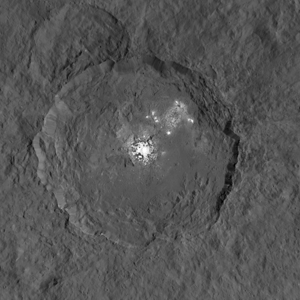
This view from NASA’s Dawn spacecraft is a color-coded topographic map of Occator crater on Ceres. Blue is the lowest elevation, and brown is the highest. The crater, which is home to the brightest spots on Ceres, is approximately 56 miles (90 kilometers wide). Credits: NASA/JPL-Caltech/UCLA/MPS/DLR/IDA
The newly released maps were created from data gathered at Dawn’s current science orbit, known as the High Altitude Mapping Orbit (HAMO) phase of the mission, during August and September.
At HAMO, Dawn is circling Ceres at an altitude of barely 915 miles (1,470 kilometers) above the heavily cratered surface.
“Dawn arrived in this third mapping orbit [HAMO] on Aug. 13. It began this third mapping phase on schedule on Aug. 17,” Dr. Marc Rayman, Dawn’s chief engineer and mission director based at NASA’s Jet Propulsion Laboratory, Pasadena, California, told Universe Today.
Each HAMO mapping orbit cycle lasts 11 days and consists of 14 orbits lasting 19 hours each. Ceres is entirely mapped during each of the 6 cycles. The third mapping cycle started on Sept. 9.
Dawn’ instruments, including the Framing Camera and Visible and Infrared Spectrometer (VIR) will be aimed at slightly different angles in each mapping cycle allowing the team to generate stereo views and construct 3-D maps.
“The emphasis during HAMO is to get good stereo data on the elevations of the surface topography and to get good high resolution clear and color data with the framing camera,” Russell told me.
“We are hoping to get lots of VIR IR data to help understand the composition of the surface better.”
“Dawn will use the color filters in its framing camera to record the sights in visible and infrared wavelengths,” notes Rayman.
The new maps at HAMO provide about three times better resolution than the images captured from its previous orbit in June, and nearly 10 times better than in the spacecraft’s initial orbit at Ceres in April and May.
This color-coded map from NASA’s Dawn shows the highs and lows of topography on the surface of dwarf planet Ceres. It is labeled with names of features approved by the International Astronomical Union. The color scale extends about 5 miles (7.5 kilometers) below the reference surface in indigo to 5 miles (7.5 kilometers) above the reference surface in white. Credits: NASA/JPL-Caltech/UCLA/MPS/DLR/IDA
The science team also released a new color-coded topographic map annotated with over a dozen Cerean feature names recently approved by the IAU.
“The names for features on Ceres are all eponymous for agricultural spirits, deities and festivals from cultures around the world. These include Jaja, after the Abkhazian harvest goddess, and Ernutet, after the cobra-headed Egyptian harvest goddess. A 12-mile (20-kilometer) diameter mountain near Ceres’ north pole is now called Ysolo Mons, for an Albanian festival that marks the first day of the eggplant harvest.”
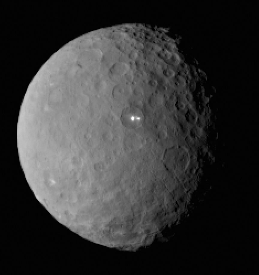
The biggest Cerean mystery of all remains the nature of the bright spots at Occator crater. It’s still under analysis and the team released a new color coded topographic map.
The imagery and other science data may point to evaporation of salty water as the source of the bright spots.
“Occasional water leakage on to the surface could leave salt there as the water would sublime,” Russell told me.
“The big picture that is emerging is that Ceres fills a unique niche,” Prof. Chris Russell, Dawn principal investigator told Universe Today exclusively.
“Ceres fills a unique niche between the cold icy bodies of the outer solar system, with their rock hard icy surfaces, and the water planets Mars and Earth that can support ice and water on their surfaces,” said Russell.
“The irregular shapes of craters on Ceres are especially interesting, resembling craters we see on Saturn’s icy moon Rhea,” says Carol Raymond, Dawn’s deputy principal investigator based at NASA’s Jet Propulsion Laboratory, Pasadena, California. “They are very different from the bowl-shaped craters on Vesta.”
This image was taken by NASA’s Dawn spacecraft of dwarf planet Ceres on Feb. 19 from a distance of nearly 29,000 miles (46,000 km). It shows that the brightest spot on Ceres has a dimmer companion, which apparently lies in the same basin. See below for the wide view. Credit: NASA/JPL-Caltech/UCLA/MPS/DLR/IDA
Dawn was launched on September 27, 2007 by a United Launch Alliance (ULA) Delta II Heavy rocket from Space Launch Complex-17B (SLC-17B) at Cape Canaveral Air Force Station, Florida.
Stay tuned here for Ken’s continuing Earth and planetary science and human spaceflight news.
This image, made using images taken by NASA’s Dawn spacecraft during the mission’s High Altitude Mapping Orbit (HAMO) phase, shows Occator crater on Ceres, home to a collection of intriguing bright spots. Credits: NASA/JPL-Caltech/UCLA/MPS/DLR/IDA
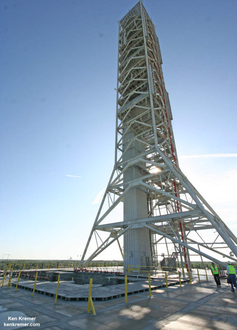
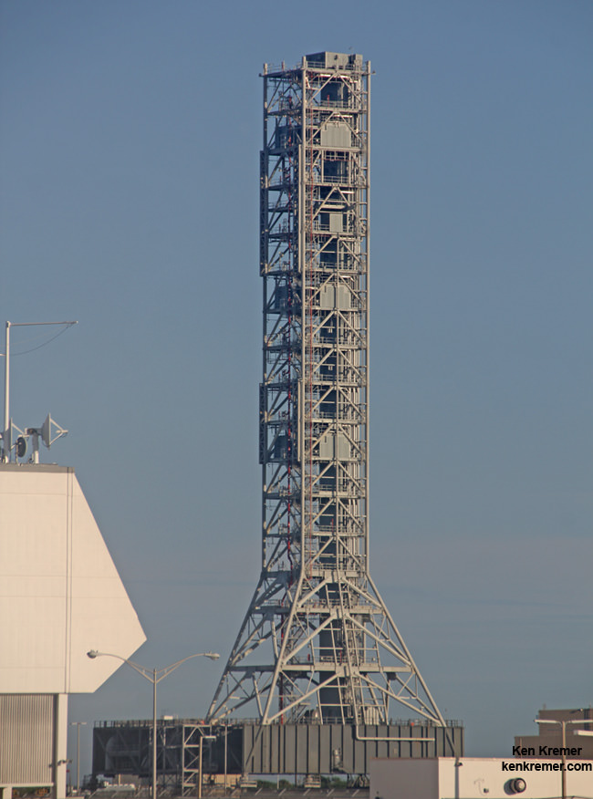
Looking up from beneath the enlarged exhaust hole of the Mobile Launcher to the 380 foot-tall tower astronauts will ascend as their gateway for missions to the Moon, Asteroids and Mars. The ML will support NASA's Space Launch System (SLS) and Orion spacecraft during Exploration Mission-1 at NASA's Kennedy Space Center in Florida. Credit: Ken Kremer/kenkremer.com
Looking up from beneath the enlarged exhaust hole of the Mobile Launcher to the 380 foot-tall tower astronauts will ascend as their gateway for missions to the Moon, Asteroids and Mars. The ML will support NASA’s Space Launch System (SLS) and Orion spacecraft during Exploration Mission-1 at NASA’s Kennedy Space Center in Florida. Credit: Ken Kremer/kenkremer.com
Story/photos updated[/caption]
KENNEDY SPACE CENTER, FL – NASA’s Mobile Launcher (ML) is undergoing major upgrades and modifications at the Kennedy Space Center in Florida enabling the massive structure to launch the agency’s mammoth Space Launch System (SLS) rocket and Orion crew capsule on a grand ‘Journey to Mars.’
“We just finished up major structural steel modifications to the ML, including work to increase the size of the rocket exhaust hole,” Eric Ernst, NASA Mobile Launch project manager, told Universe Today during an exclusive interview and inspection tour up and down the Mobile Launcher.
Construction workers are hard at work upgrading and transforming the 380-foot-tall, 10.5-million-pound steel structure into the launcher for SLS and Orion – currently slated for a maiden blastoff no later than November 2018 on Exploration Mission-1 (EM-1).
“And now we have just started the next big effort to get ready for SLS.”
SLS and Orion are NASA’s next generation human spaceflight vehicles currently under development and aimed at propelling astronauts to deep space destinations, including the Moon and an asteroid in the 2020s and eventually a ‘Journey to Mars’ in the 2030s.
Floor level view of the Mobile Launcher and enlarged exhaust hole with 380 foot-tall launch tower astronauts will ascend as their gateway for missions to the Moon, Asteroids and Mars. The ML will support NASA’s Space Launch System (SLS) and Orion spacecraft for launches from Space Launch Complex 39B at the Kennedy Space Center in Florida. Credit: Ken Kremer/kenkremer.com
The mobile launcher was originally built several years ago to accommodate NASA’s less powerful, lighter and now cancelled Ares-1 rocket. It therefore requires extensive alterations to accommodate the vastly more powerful and heavier SLS rocket.
“The ML was initially developed for Ares 1, a much smaller rocket,” Ernst explained to Universe Today.
“So the exhaust hole was much smaller.”
Whereas the Ares-1 first stage booster was based on using a single, more powerful version of the Space Shuttle Solid Rocket Boosters, the SLS first stage is gargantuan and will be the most powerful rocket the world has ever seen.
The SLS first stage comprises two shuttle derived solid rocket boosters and four RS-25 power plants recycled from their earlier life as space shuttle main engines (SSMEs). They generate a combined 8.4 million pounds of thrust – exceeding that of NASA’s Apollo Saturn V moon landing rocket.
Therefore the original ML exhaust hole had to be gutted and nearly tripled in width.
“The exhaust hole used to be about 22 x 22 feet,” Ernst stated.
“Since the exhaust hole was much smaller, we had to deconstruct part of the tower at the base, in place. The exhaust hole had to be made much bigger to accommodate the SLS.”
Construction crews extensively reworked the exhaust hole and made it far wider to accommodate SLS compared to the smaller one engineered and already built for the much narrower Ares-1, which was planned to generate some 3.6 million pounds of thrust.
“So we had to rip out a lot of steel,” Mike Canicatti, ML Construction Manager told Universe Today.
“For the exhaust hole [at the base of the tower], lots of pieces of [existing] steel were taken out and other new pieces were added, using entirely new steel.”
“The compartment for the exhaust hole used to be about 22 x 22 feet, now it’s about 34 x 64 feet.”
Looking down to the enlarged 64 foot wide exhaust hole from the top of NASA’s 380 foot-tall Mobile Launch tower. Astronauts will board the Orion capsule atop the Space Launch System (SLS) rocket for launches from Space Launch Complex 39B the Kennedy Space Center in Florida. Credit: Ken Kremer/kenkremer.com
In fact this involved the demolition of over 750 tons of old steel following by fabrication and installation of more than 1,000 tons of new steel. It was also reinforced due to the much heavier weight of SLS.
“It was a huge effort and structural engineers did their job. The base was disassembled and reassembled in place” – to enlarge the exhaust hole.
“So basically we gutted major portions of the base out, put in new walls and big structural girders,” Ernst elaborated.
“And we just finished up that major structural steel modification on the exhaust hole.”
Top view across the massive 34 foot-wide, 64 foot-long exhaust hole excavated out of NASA’s Mobile Launcher that will support launches of the Space Launch System (SLS) rocket from Space Launch Complex 39B at the Kennedy Space Center in Florida. Credit: Ken Kremer/kenkremer.com
Meanwhile the 380 foot-tall tower that future Orion astronauts will ascend was left in place.
“The tower portion itself did not need to be disassembled.”
The Ares rockets originally belonged to NASA’s Constellation program, whose intended goal was returning American astronauts to the surface of the Moon by 2020.
Ares-1 was slated as the booster for the Orion crew capsule. However, President Obama cancelled Constellation and NASA’s Return to the Moon soon after entering office.
Since then the Obama Administration and Congress worked together in a bipartisan manner together to fashion a new space hardware architecture and granted approval for development of the SLS heavy lift rocket to replace the Ares-1 and heavy lift Ares-5.
Sending astronauts on a ‘Journey to Mars’ is now NASA’s agency wide and overarching goal for the next few decades of human spaceflight.
But before SLS can be transported to its launch pad at Kennedy’s Space Launch Complex 39-B for the EM-1 test flight the next big construction step has to begin.
“So now we have just started the next big effort to get ready for SLS.”
This involves installation of Ground Support Equipment (GSE) and a wide range of launch support services and systems to the ML.
“The next big effort is the GSE installation contract,” Ernst told me.
“We have about 40+ ground support and facility systems to be installed on the ML. There are about 800 items to be installed, including about 300,000-plus feet of cable and several miles of piping and tubing.”
“So that’s the next big effort to get ready for SLS. It’s about a 1.5 year contract and it was just awarded to J.P. Donovan Construction Inc. of Rockledge, Florida.”
“The work just started at the end of August.”
NASA currently plans to roll the ML into the Vehicle Assembly Building in early 2017 for stacking of SLS and Orion for the EM-1 test flight.
View of NASA’s future SLS/Orion launch pad at Space Launch Complex 39B from atop Mobile Launcher at the Kennedy Space Center in Florida. Former Space Shuttle launch pad 39B is now undergoing renovations and upgrades to prepare for SLS/Orion flights starting in 2018. Credit: Ken Kremer/kenkremer.com
The SLS/Orion mounted stack atop the ML will then roll out to Space Launch Complex 39B for the 2018 launch from the Kennedy Space Center.
Pad 39B is also undergoing radical renovations and upgrades, transforming it from its use for NASA’s now retired Space Shuttle program into a modernized 21st century launch pad. Watch for my upcoming story.
Artist concept of the SLS Block 1 configuration mounted on the Mobile Launcher. Credit: NASA
Stay tuned here for Ken’s continuing Earth and planetary science and human spaceflight news.
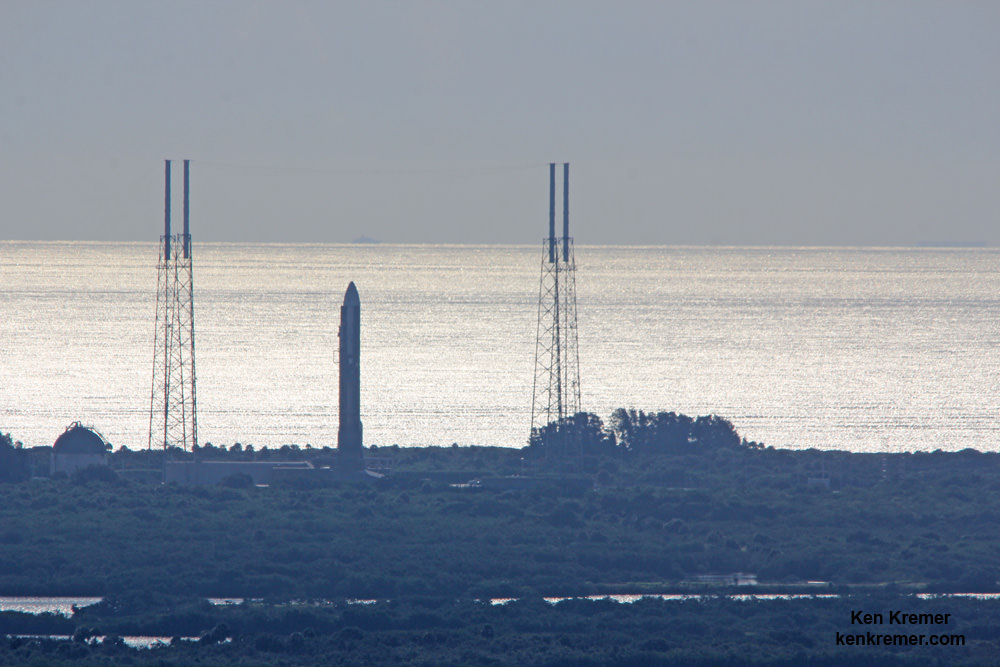
View from atop NASA’s SLS mobile launcher at the Kennedy Space Center, looking out to United Launch Alliance Atlas V rocket with MUOS-4 US Navy communications satellite poised at pad 41 at Cape Canaveral Air Force Station, FL, ‘prior to launch on Sept. 2, 2015. EDT. Credit: Ken Kremer/kenkremer.com
These dark, narrow, 100 meter-long streaks called recurring slope lineae flowing downhill on Mars are inferred to have been formed by contemporary flowing water. However, a new study by planetary scientists indicates that these may actually be the result of dry flows. Credits: NASA/JPL/University of Arizona
These dark, narrow, 100 meter-long streaks called recurring slope lineae flowing downhill on Mars are inferred to have been formed by contemporary flowing water. Recently, planetary scientists detected hydrated salts on these slopes at Hale crater, corroborating their original hypothesis that the streaks are indeed formed by liquid water. The blue color seen upslope of the dark streaks are thought not to be related to their formation, but instead are from the presence of the mineral pyroxene.
The image is produced by draping an orthorectified Infrared-Red-Blue/Green(IRB)) false color image on a Digital Terrain Model (DTM). This model was produced by researchers at the University of Arizona, much like the High Resolution Imaging Science Experiment (University of Arizona). The vertical exaggeration is 1.5.
NASA and Mars planetary scientists announced today (Sept. 28) that salty “liquid water flows intermittently” across multiple spots on the surface of today’s Mars – trumpeting a major scientific discovery with far reaching implications regarding the search for life beyond Earth and bolstering the chances for the possible existence of present day Martian microbes.
Utilizing spectroscopic measurements and imaging gathered by NASA’s Mars Reconnaissance Orbiter (MRO), researchers found the first strong evidence confirming that briny water flows on the Red Planet today along dark streaks moving downhill on crater slopes and mountain sides, during warmer seasons.
“Mars is not the dry, arid planet that we thought of in the past. Today we announce that under certain circumstances, liquid water has been found on Mars,” said Jim Green, NASA Planetary Science Director at NASA Headquarters, at a media briefing held today, Sept 28.
“When you look at Earth, water is an essential ingredient. Everywhere we go where there’s liquid water, whether its deep in the Earth or in the arid regions, we find life. This is tremendously exciting.”
“We haven’t been able to answer the question – does life exist beyond Earth? But following the water is a critical element of that. We now have great opportunities to be in the right locations on Mars to thoroughly investigate that,” Green elaborated.
“Water! Strong evidence that liquid water flows on present-day Mars,” NASA officials tweeted about the discovery.
The evidence comes in the form of the detection of mysterious dark streaks, as long as 100 meters, showing signatures of hydrated salt minerals periodically flowing in liquid water down steep slopes on the Red Planet that “appear to ebb and flow over time.”
The source of the water is likely from the shallow subsurface or possibly absorbed from the atmosphere.
Dark narrow streaks called recurring slope lineae emanating out of the walls of Garni crater on Mars. The dark streaks here are up to few hundred meters in length. They are hypothesized to be formed by flow of briny liquid water on Mars. The image is produced by draping an orthorectified (RED) image (ESP_031059_1685) on a Digital Terrain Model (DTM) of the same site produced by High Resolution Imaging Science Experiment (University of Arizona). Vertical exaggeration is 1.5. Credits: NASA/JPL/University of Arizona
Water is a key prerequisite for the formation and evolution of life as we know it. So the new finding significantly bolsters the chances that present day extant life could exist on the Red Planet.
“Our quest on Mars has been to ‘follow the water,’ in our search for life in the universe, and now we have convincing science that validates what we’ve long suspected,” said John Grunsfeld, astronaut and associate administrator of NASA’s Science Mission Directorate in Washington.
“This is a significant development, as it appears to confirm that water — albeit briny — is flowing today on the surface of Mars.”
“This increases the chance that life could exist on Mars today,” noted Grunsfeld.
The data were gathered by and the conclusions are based on using two scientific instruments – the high resolution imaging spectrometer on MRO known as High Resolution Imaging Science Experiment (HiRISE), as well as MRO’s mineral mapping Compact Reconnaissance Imaging Spectrometer for Mars (CRISM).
The mysterious dark streaks of downhill flows are known as recurring slope lineae (RSL).
They were first detected in 2010 at dozens of sites on the sun facing slopes of deep craters by Lujendra Ojha, then a University of Arizona undergraduate student.
The new finding is highly significant because until today’s announcement, there was no strong evidence that liquid water could actually exist on the Martian surface because the atmospheric pressure was thought to be far too low – its less than one percent of Earth’s.
The flow of water is occasional and not permanent, seasonally variable and dependent on having just the right mix of atmospheric, temperature and surface conditions with salt deposits on Mars.
Portions of Mars were covered with an ocean of water billions of years ago when the planet was far warmer and more hospitable to life. But it underwent a dramatic climate change some 3 billion years ago and lost most of that water.
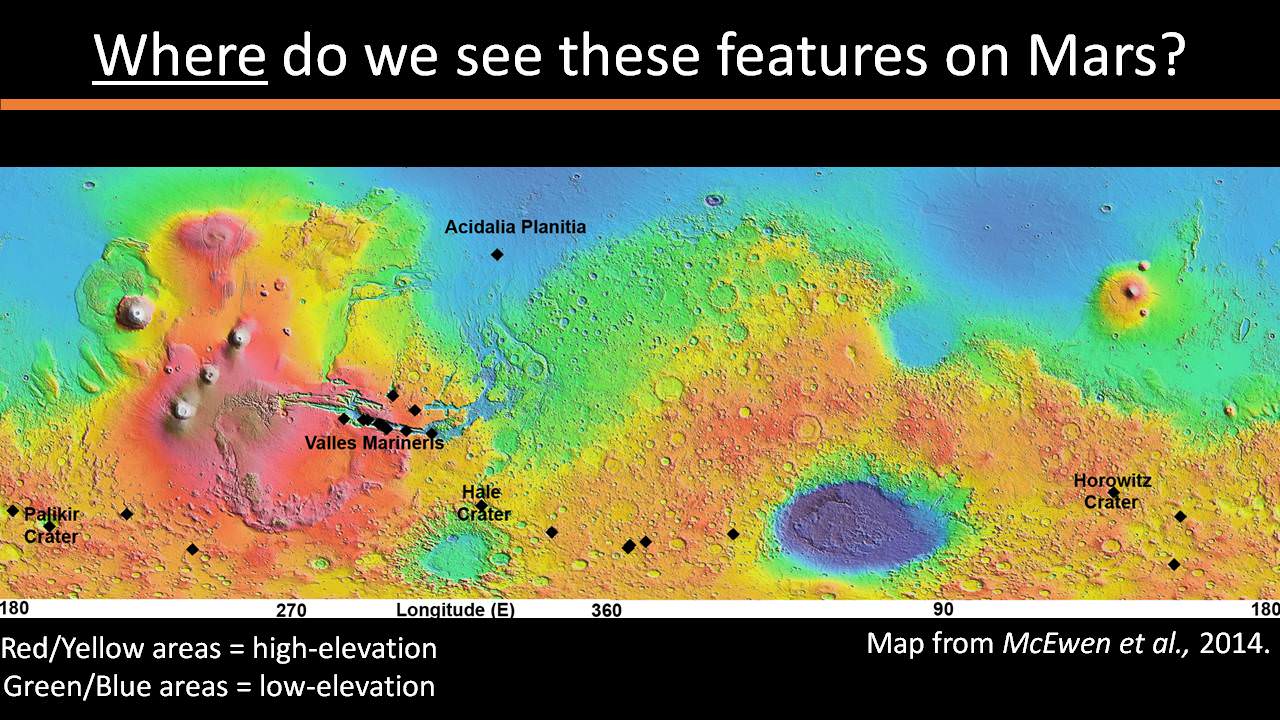
The RSL with flowing water appear in at least three different locations on Mars – including Hale crater, Horowitz crater and Palikir crater – when temperatures are above minus 10 degrees Fahrenheit (minus 23 Celsius). They appear during warm seasons, fade in cooler seasons and disappear during colder times.
Pure surface water ice would simply sublimate and evaporate away as the temperature rises. Mixing in surface salts lowers the melting point of ice, thereby allowing the water to potentially liquefy on Mars surface for a certain period of time rather than sublimating rapidly away.
“These are dark streaks that form in late spring, grow through the summer and then disappear in the fall,” said Michael Meyer lead scientist for the Mars Exploration Program at NASA Headquarters, at the media briefing.
Years of painstaking effort and laboratory work was required to verify and corroborate the finding of flowing liquid water.
“It took multiple spacecraft over several years to solve this mystery, and now we know there is liquid water on the surface of this cold, desert planet,” said Meyer. “It seems that the more we study Mars, the more we learn how life could be supported and where there are resources to support life in the future.”
The dark, narrow streaks flowing downhill on Mars at sites such as this portion of Horowitz Crater are inferred to be formed by seasonal flow of water on modern-day Mars. The streaks are roughly the length of a football field. These dark features on the slopes are called “recurring slope lineae” or RSL. The imaging and topographical information in this processed view come from the High Resolution Imaging Science Experiment (HiRISE) camera on NASA’s Mars Reconnaissance Orbiter. Credit: NASA/JPL-Caltech/Univ. of Arizona
Along with the media announcement, the researchers published their findings today in a refereed scientific paper in the Sept. 28 issue of Nature Geoscience.
“We found the hydrated salts only when the seasonal features were widest, which suggests that either the dark streaks themselves or a process that forms them is the source of the hydration. In either case, the detection of hydrated salts on these slopes means that water plays a vital role in the formation of these streaks,” said Lujendra Ojha, now at the Georgia Institute of Technology (Georgia Tech) in Atlanta, and lead author of the Sept. 28 publication in Nature Geoscience.
The scientists “interpret the spectral signatures as caused by hydrated minerals called perchlorates.”
Ojha said the chemical signatures from CRISM were most consistent with the detection of mixtures of magnesium perchlorate, magnesium chlorate and sodium perchlorate, based on lab experiments.
“Some perchlorates have been shown to keep liquids from freezing even when conditions are as cold as minus 94 degrees Fahrenheit (minus 70 Celsius).”
Perchlorates have previously been detected in Martian soil by two of NASA’s surface missions – the Phoenix lander and the Curiosity rover. There is also some evidence that NASA’s Viking missions in the 1970s measured signatures of these salts.
On Earth concentration of perchlorates are found in deserts.
This also marks the first time perchlorates have been identified from Mars orbit.
So NASA astronaut Mark Kelly exclaimed that he was also super excited about the findings, from his perch serving as Commander aboard the International Space Station (ISS), where he is a member of the first ever “1 Year ISS Mission Crew” aimed at learning how the human body will adapt to the long term missions required to send astronauts to Mars and back.
“One reason why NASA’s discovery of liquid water on #Mars is so exciting: we know anywhere there’s water on Earth, there’s some form of life,” Kelly tweeted today from on board the ISS, upon hearing today’s news.
The discovery of liquid water on Mars could also be a boon to future astronauts who could use it as a natural resource to ‘live off the land’ for sustenance and to make rocket fuel.
“If going to Mars on my Year In Space, I’d arrive soon to find water! H20 > rocket fuel, which means I could find my way back home too!,” Kelly wrote on his Facebook page.
“When most people talk about water on Mars, they’re usually talking about ancient water or frozen water,” Ojha explained.
“Now we know there’s more to the story. This is the first spectral detection that unambiguously supports our liquid water-formation hypotheses for RSL.”
Stay tuned here for Ken’s continuing Earth and planetary science and human spaceflight news.
This color image of Pluto taken by NASA’s New Horizons spacecraft shows rounded and bizarrely textured mountains, informally named the Tartarus Dorsa, rise up along Pluto’s terminator and show intricate but puzzling patterns of blue-gray ridges and reddish material in between. This view, roughly 330 miles (530 kilometers) across, combines blue, red and infrared images taken by the Ralph/Multispectral Visual Imaging Camera (MVIC) on July 14, 2015, and resolves details and colors on scales as small as 0.8 miles (1.3 kilometers). Credits: NASA/JHUAPL/SWRI
Data from that priceless, once in a lifetime flyby is now trickling back to Earth.
The ‘snakeskin’ feature on Pluto’s utterly bizarre surface was unveiled to “astonished” scientists scrutinizing the latest data dump received over the past week, that included images taken by the Ralph instruments Multispectral Visual Imaging Camera (MVIC).
Features as small as 0.8 miles (1.3 kilometers) are resolved in detail.
The MVIC image stretches about 330 miles (530 kilometers) across the ‘snakeskin’ like landscape composed of rounded and bizarrely textured mountains that are informally named Tartarus Dorsa and that borders the bodies day-night terminator.
It shows intricate patterns of blue-gray ridges and reddish material in between that are puzzling researchers.
“It’s a unique and perplexing landscape stretching over hundreds of miles,” said William McKinnon, New Horizons Geology, Geophysics and Imaging (GGI) team deputy lead from Washington University in St. Louis.
“It looks more like tree bark or dragon scales than geology. This’ll really take time to figure out; maybe it’s some combination of internal tectonic forces and ice sublimation driven by Pluto’s faint sunlight.”
The Ralph/MVIC image is actually a composite of blue, red and infrared images.
The image of Tartarus Dorsa reveals a “multitude of previously unseen topographic and compositional details. It captures a vast rippling landscape of strange, aligned linear ridges that has astonished New Horizons team members,” say officials.
NASA’s New Horizons spacecraft captured this high-resolution enhanced color view of Pluto on July 14, 2015. The image combines blue, red and infrared images taken by the Ralph/Multispectral Visual Imaging Camera (MVIC). Pluto’s surface sports a remarkable range of subtle colors, enhanced in this view to a rainbow of pale blues, yellows, oranges, and deep reds. Many landforms have their own distinct colors, telling a complex geological and climatological story that scientists have only just begun to decode. The image resolves details and colors on scales as small as 0.8 miles (1.3 kilometers). The viewer is encouraged to zoom in on the image on a larger screen to fully appreciate the complexity of Pluto’s surface features. Credit: NASA/JHUAPL/SwRI
Another wider angle global view of Pluto downlinked on Sept. 19 shows a new “extended color” view of Pluto with an the extraordinarily rich color palette of the planet.
“We used MVIC’s infrared channel to extend our spectral view of Pluto,” said John Spencer, a GGI deputy lead from Southwest Research Institute (SwRI) in Boulder, Colorado.
“Pluto’s surface colors were enhanced in this view to reveal subtle details in a rainbow of pale blues, yellows, oranges, and deep reds. Many landforms have their own distinct colors, telling a wonderfully complex geological and climatological story that we have only just begun to decode.”
The image resolves details and colors on scales as small as 0.8 miles (1.3 kilometers).
High-resolution images of Pluto taken by NASA’s New Horizons spacecraft just before closest approach on July 14, 2015, reveal features as small as 270 yards (250 meters) across, from craters to faulted mountain blocks, to the textured surface of the vast basin informally called Sputnik Planum. Enhanced color has been added from the global color image. This image is about 330 miles (530 kilometers) across. For optimal viewing, zoom in on the image on a larger screen. Credits: NASA/JHUAPL/SWRI
Beyond MVIC, additional new images taken by New Horizons’ narrow-angle Long Range Reconnaissance Imager (LORRI) during the July 14 were downlinked on Sept. 20.
They focus on the Sputnik Planum ice plains on the left side of the famous heart shaped Tombaugh Regio feature and are the highest resolution yet – as seen below. The team added color based on the global MVIC map shown above.
High-resolution images of Pluto taken by NASA’s New Horizons spacecraft just before closest approach on July 14, 2015, are the sharpest images to date of Pluto’s varied terrain—revealing details down to scales of 270 meters. In this 75-mile (120-kilometer) section of the taken from a larger, high-resolution mosaic, the textured surface of the plain surrounds two isolated ice mountains. Credits: NASA/JHUAPL/SWRI
Barely 5 or 6 percent of the 50 gigabits of data captured by New Horizons has been received by ground stations back on Earth.
“With these just-downlinked images and maps, we’ve turned a new page in the study of Pluto beginning to reveal the planet at high resolution in both color and composition,” added New Horizons Principal Investigator Alan Stern, of SwRI.
“I wish Pluto’s discoverer Clyde Tombaugh had lived to see this day.”
Stern says it will take about a year for all the data to get back. Thus bountiful new discoveries are on tap.
This new global mosaic view of Pluto was created from the latest high-resolution images to be downlinked from NASA’s New Horizons spacecraft and released on Sept. 11, 2015. The images were taken as New Horizons flew past Pluto on July 14, 2015, from a distance of 50,000 miles (80,000 kilometers). This mosaic was stitched from over two dozen raw images captured by the LORRI imager and colorized. Right side mosaic comprises twelve highest resolution views of Tombaugh Regio heart shaped feature and shows objects as small as 0.5 miles (0.8 kilometers) in size. Credits: NASA/Johns Hopkins University Applied Physics Laboratory/Southwest Research Institute/ Ken Kremer/kenkremer.com/Marco Di Lorenzo
Stay tuned here for Ken’s continuing Earth and planetary science and human spaceflight news.
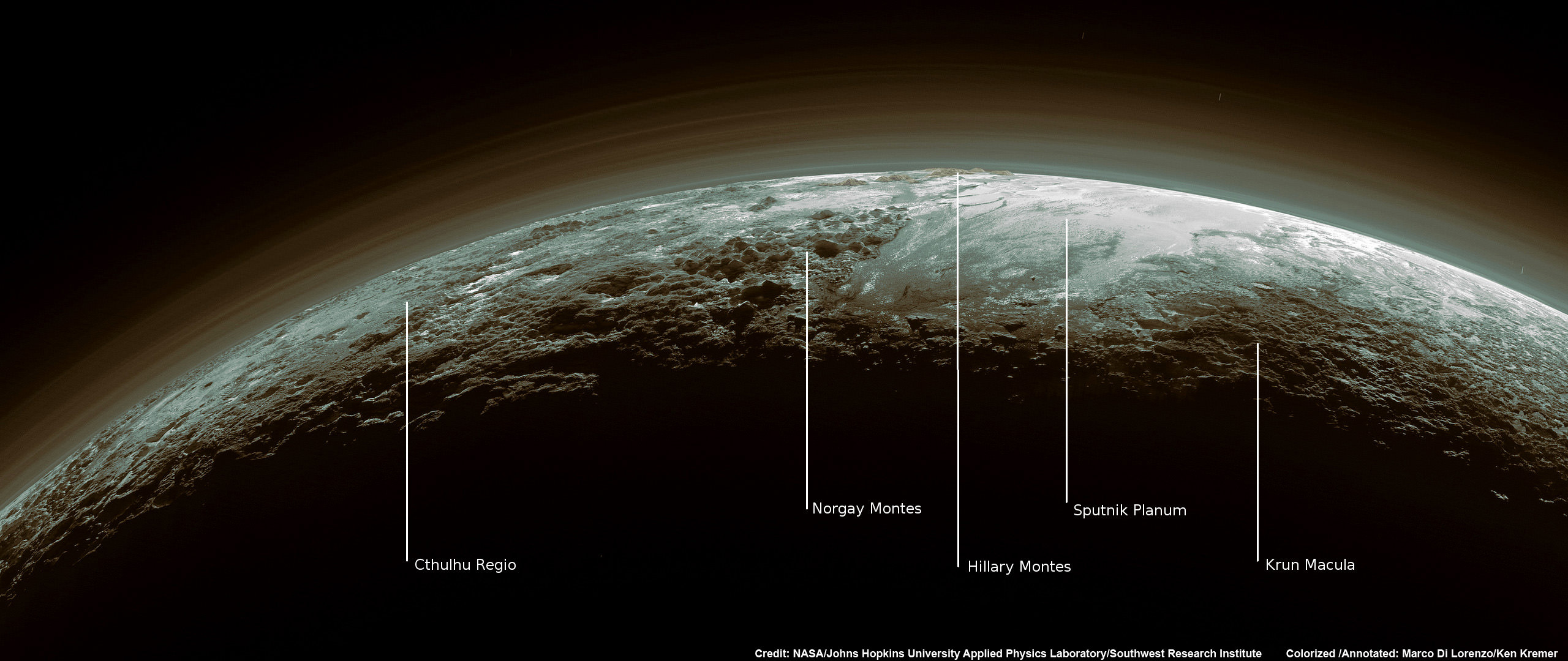
Just 15 minutes after its closest approach to Pluto on July 14, 2015, NASA’s New Horizons spacecraft looked back toward the sun and captured this near-sunset view of the rugged, icy mountains and flat ice plains extending to Pluto’s horizon – shown in this colorized rendition. The smooth expanse of the informally named icy plain Sputnik Planum (right) is flanked to the west (left) by rugged mountains up to 11,000 feet (3,500 meters) high, including the informally named Norgay Montes in the foreground and Hillary Montes on the skyline. To the right, east of Sputnik, rougher terrain is cut by apparent glaciers. The backlighting highlights more than a dozen layers of haze in Pluto’s tenuous but distended atmosphere. The image was taken from a distance of 11,000 miles (18,000 kilometers) to Pluto; the scene is 780 miles (1,250 kilometers) wide. Credit: NASA/Johns Hopkins University Applied Physics Laboratory/Southwest Research Institute. Colorized/Annotated: Marco Di Lorenzo/Ken Kremer/kenkremer.com
Watched @MartianMovie on @Space_Station last night! Today working towards our #JourneyToMars during my #YearInSpace!” Credit: NASA/Scott Kelly
Video caption: ‘The Martian’ Star Matt Damon Discusses NASA’s Journey to Mars. Credit: NASA
The excitement is building for the worldwide movie premiere of ‘The Martian’ on Oct. 2.
Based on the bestselling book by Andy Weir, ‘The Martian’ tells the story of how NASA astronaut Mark Watney, played by Matt Damon, is accidentally stranded on the surface of Mars during a future manned expedition, after a sudden and unexpectedly fierce dust storm forces the rest of the crew to quickly evacuate after they believe he is dead.
In the video above, Matt Damon discusses NASA’s ongoing real life efforts focused on turning science fiction dreams into reality and sending astronauts to Mars.
Watney actually survived the storm but lost contact with NASA. The film recounts his ingenious years long struggle to survive, figure out how to tell NASA he is alive and send a rescue crew before he starves to death on a planet where nothing grows. Watney’s predicament is a survival lesson to all including NASA.
‘The Martian’ was written by Andy Weir in 2010 and has now been produced as a major Hollywood motion picture starring world famous actor Matt Damon and directed by the world famous director Ridley Scott from 20th Century Fox.
NASA’s overriding strategic goal is to send humans on a ‘Journey to Mars’ by the 2030s.
‘The Martian’ is a rather realistic portrayal of how NASA might accomplish the ‘Journey to Mars.’
“Sending people to Mars and returning them safely is the challenge of a generation,” says Damon in the video.
“The boot prints of astronauts will follow the rover tracks [of NASA’s Curiosity rover] thanks to innovations happening today.”
“NASA’s Journey to Mars begins on the International Space Station (ISS) .. where we are learning how humans can thrive over long periods without gravity.”
The current six person crew serving aboard the ISS even got a sneak preview of The Martian this past weekend!
Gleeful NASA astronaut Scott Kelly, commander of the Expedition 45 crew, just tweeted a photo of the crew watching ‘The Martian’ while soaring some 250 miles (400 kilometers) above Earth.
“Watched @MartianMovie on @Space_Station last night! Today working towards our #JourneyToMars during my #YearInSpace!” tweeted NASA astronaut Scott Kelly.
Kelly comprises one half of the first ever ‘1 Year ISS Crew’ along with Russian cosmonaut Mikhail Kornienko, aimed at determining the long term physical and psychological effects on the human body of people living and working in the weightlessness of space.
The 1 Year ISS mission is an important data gathering milestone on the human road to Mars since the round trip time to the Red Planet and back will take approximately 3 years or more.
The first unmanned test flight of SLS/Orion is slated for Nov. 2018. The first manned flight could occur between 2021 and 2023 – read my new report here.
“The Journey to Mars will forever change our history books … and expand our human presence deeper into the solar system,” says Damon.
THE MARTIAN features a star studded cast that includes Matt Damon, Jessica Chastain, Kristen Wiig, Kate Mara, Michael Pena, Jeff Daniels, Chiwetel Ejiofor, and Donald Glover.
Matt Damon stars as NASA astronaut Mark Watney in ‘The Martian.’ Credit: 20th Century Fox
“NASA has endorsed “The Martian’” Jim Green, NASA’s Director of Planetary Sciences, told Universe Today. Green served as technical consultant on the film.
I have read the book (I’m a professional chemist) and highly recommend it to everyone.
The Martian is all about how Watney uses his botany and chemistry skills to “Science the Sh.. out of it” to grow food and survive.
Learning how to live of the land will be a key hurdle towards enabling long term space voyages.
Kelly and his ISS cremates took a big first step towards putting that theory into practice when they recently grew, harvested and ate the first space grown NASA lettuce on the ISS using the Veggie experimental rack – detailed in my recent story here.
NASA Astronauts Kjell Lindgren (center) and Scott Kelly (right) and Kimiya Yui (left) of Japan consume space grown food for the first time ever, from the Veggie plant growth system on the International Space Station. Credit: NASA TV
Here’s the second official trailer of “The Martian:
Stay tuned here for Ken’s continuing Earth and planetary science and human spaceflight news.
Veggie demonstration apparatus growing red romaine lettuce under LED lights in the Space Station Processing Facility at NASA’s Kennedy Space Center. Credit: Ken Kremer/kenkremer.com
Rendering of the ULA Vulcan rocket blasting off. United Launch Alliance (ULA) next generation rocket is set to make its debut flight in 2019. Credit: ULA
Aerojet Rocketdyne, which supplies critical rocket engines powering ULA’s fleet of Atlas and Delta rockets, recently made an unsolicited offer to buy ULA for approximately $2 Billion in cash, as Universe Today reported last week.
The Vulcan is planned to replace all of ULA’s existing rockets – which are significantly more costly than those from rival launch provider SpaceX, founded by billionaire entrepreneur Elon Musk.
Boeing never “seriously entertained” the Aerojet-Rocketdyne buyout offer, Universe Today confirmed with Boeing spokesperson Cindy Anderson.
Meanwhile in stark contrast to Boeing, Lockheed Martin has “no comment” regarding the Aerojet-Rocketdyne offer to buy ULA, Universe Today confirmed with Lockheed Martin Director External Communications Matt Kramer.
Furthermore Lockheed Martin is not only noncommittal about the future of ULA but is also “currently assessing our options” concerning the development of ULA’s Vulcan rocket, Kramer told me.
“With regard to reports of an unsolicited proposal for ULA, it is not something we seriously entertained for a number of reasons,” Boeing spokesperson Anderson told Universe Today.
“Regarding Aerojet and ULA, as a matter of policy Lockheed Martin does not have a comment,” Lockheed Martin spokesman Kramer told Universe Today.
Vulcan – United Launch Alliance (ULA) next generation rocket is set to make its debut flight in 2019. Credit: ULA
ULA was formed in 2006 as a 50:50 joint venture between Lockheed Martin and Boeing that combined their existing expendable rocket fleet families – the Atlas V and Delta IV – under one roof.
Who owns ULA is indeed of significance to all Americans – although most have never head of the company – because ULA holds a virtual monopoly on launches of vital US government national security payloads and the nation’s most critical super secret spy satellites that safeguard our national defense 24/7. ULA’s rocket fleet also launched scores of NASA’s most valuable science satellites including the Curiosity Mars rover, Dawn and New Horizons Pluto planetary probe.
Since 2006 ULA has enjoyed phenomenal launch success with its venerable fleet of Atlas V and Delta IV rockets.
“ULA is a huge part of our strategic portfolio going forward along with our satellites and manned space business. This bid we’ve really not spent much time on it at all because we’re focusing on a totally different direction,” said Chris Chadwick, president and chief executive of Boeing Defense, Space & Security, on Sept. 16 at the Air Force Association’s annual technology expo in National Harbor, Maryland – according to a report by Space News.
Boeing offered strong support for ULA and the Vulcan rocket.
Vulcan is ULA’s next generation rocket to space that can propel payloads to low Earth orbit as well as throughout the solar system – including Pluto. It is slated for an inaugural liftoff in 2019.
Vulcan’s continued development is being funded by Lockheed Martin and Boeing, but only on a quarterly basis.
The key selling point of Vulcan is that it will be an all American built rocket and it will dramatically reduce launch costs to compete toe to toe with the SpaceX Falcon rocket family.
And there is a heated competition on which of two companies will provide the new American built first stage engine that will replace the Russian-built RD-180 that currently powers the ULA Atlas V.
Vulcan’s first stage will most likely be powered by the BE-4 engine being developed by the secretive Blue Origin aerospace firm owned by billionaire Jeff Bezos.
This week ULA announced an expanded research agreement with Blue Origin about using the BE-4.
But ULA is also evaluating the AR-1 liquid fueled engine being developed by Aerojet-Rocketdyne – the company that wants to buy ULA.
The Atlas V dependence on Russia’s RD-180’s landed at the center of controversy after Russia invaded Crimea in the spring of 2014, raising the ire of Congress and enactment of a ban on their use several years in the future.
ULA is expected to make a final decision on which first stage engine to use between Blue Origin and Aerojet-Rocketdyne, sometime in 2016.
The engine choice would clearly be impacted if Aerojet-Rocketdyne buys ULA.
Boeing for its part says they strongly support ULA and continued development of the Vulcan.
“Boeing is committed to ULA and its business, and to continued leadership in all aspects of space, as evidenced by the recent announcement of an agreement with Blue Origin,” Boeing spokesperson Anderson told me.
Lockheed Martin in complete contrast did not express any long term commitment to Vulcan and just remarked they were merely “actively evaluating continued investment,” as is their right as a stakeholder.
“We have made no long-term commitments on the funding of a new rocket, and are currently assessing our options. The board is actively evaluating continued investment in the new rocket program and will continue to do so,” Lockheed Director, External Communications Matt Kramer told Universe Today.
Another factor is that Aerojet-Rocketdyne has also sought to buy the rights to manufacture the Atlas V from ULA, which is currently planned to be retired several years after Vulcan is introduced, officials have told me.
Aerojet-Rocketdyne made a bid to buy ULA, manufacturer of the Atlas V, for approximately $2 Billion. MUOS-4 US Navy communications satellite and Atlas V rocket at pad 41 at Cape Canaveral Air Force Station, FL for launch on Sept. 2, 2015 at 5:59 a.m. EDT. Credit: Ken Kremer/kenkremer.com
The Atlas V enjoys unparalleled success. Earlier this month on Sept. 2, ULA conducted its 99th launch with the successful blastoff of an Atlas V with the MUOS-4 military communications satellite from Cape Canaveral Air Force Station for the U.S. Navy.
Starliner will eventually blastoff atop Vulcan after the Atlas V is retired in the next decade.
Lockheed provided me this update on Vulcan and ULA on Sept 21:
“Lockheed Martin is proud of ULA’s unparalleled track record of mission success, with 99 consecutive successful launches to date. We support the important role ULA plays in providing the nation with assured access to space. ULA’s Vulcan rocket takes the best performance elements of Atlas and Delta and combines them in a new system that will be superior in reliability, cost, weight, and capability. The government is working to determine its strategy for an American-made engine and future launch services. As they make those determinations we’ll adjust our strategy to make sure we’re aligned with the government’s objectives and goals.”
Stay tuned here for Ken’s continuing Earth and planetary science and human spaceflight news.
First view of upper half of the Boeing CST-100 ‘Starliner’ crewed space taxi unveiled at the Sept. 4, 2015 Grand Opening ceremony held in the totally refurbished C3PF manufacturing facility at NASA’s Kennedy Space Center. This will be part of the first Starliner crew module known as the Structural Test Article (STA) being built at Boeing’s Commercial Crew and Cargo Processing Facility (C3PF) at KSC. Credit: Ken Kremer /kenkremer.com