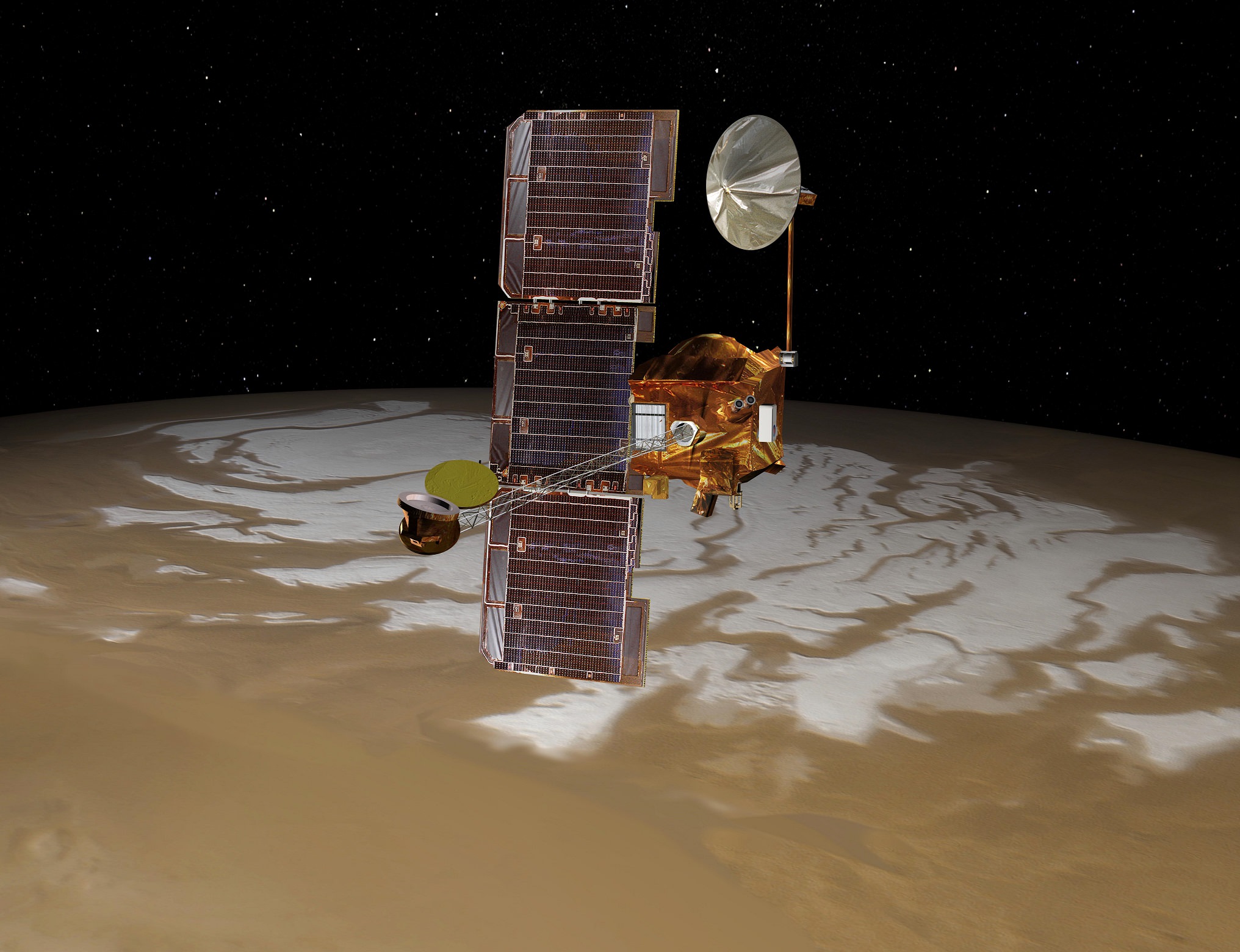
Artist's conception of the Mars Odyssey spacecraft. Credit: NASA/JPL
Just a few days ago, we posted about possibly salty water flows on Mars. Of note, the NASA press release noted, moisture is likely more prevalent in the morning and the Mars Reconnaissance Orbiter does most observations in the afternoon, local time. That’s too bad, we thought. But wait! It turns out that NASA Mars Odyssey spacecraft is going to change its orbit to get a better look.
It’s going to take nearly two years for NASA to maneuver the long-running Odyssey to the right spot, but at that point mission managers expect the spacecraft still has another decade of observations ahead of it based on current fuel consumption. That’s great considering that the spacecraft has been beaming back images since 2001!
Odyssey will be the first spacecraft to do dedicated morning observations of the planet since any NASA orbiter of the 1970s, which dates observations back to the Viking era (except for a few glimpses by European Space Agency spacecraft and previous NASA orbiters). Advances in imaging mean we will get a far clearer view of the ground than ever before.
“The change will enable observation of changing ground temperatures after sunrise and after sunset in thousands of places on Mars,” NASA stated. “Those observations could yield insight about the composition of the ground and about temperature-driven processes, such as warm-season flows observed on some slopes, and geysers fed by spring thawing of carbon-dioxide ice near Mars’ poles.”
Morning water-ice clouds on Mars spotted by Viking 1 in 1976. Mars Odyssey’s new orbit will reveal more of these types of morning observations. Credit: NASA/JPL
The first maneuver took place Tuesday (Feb. 11) when a brief firing of Odyssey’s engines got the spacecraft pushing faster for an orbital shift. It will drift in that direction until November 2015, when controllers will do another maneuver to keep it in a stable location.
Right now, Odyssey is in a near-polar orbit that keeps local daylight at the same time below it. There have been a few changes to the timing over its dozen years of operation:
First six years (approx. 2001-2007): The orbit was mostly at 5 p.m. local solar time (as it flew north to south) and 5 a.m. local solar time on the south-to-north orbit. “That orbit provided an advantage for the orbiter’s Gamma Ray Spectrometer to have its cooling equipment pointed away from the sun,” NASA stated. At that time, the spectrometer found evidence of water ice, through the spectrum of hydrogen.
Next five years (approx. 2007-2012): The orbit shifted to 4 p.m. local solar time on north-to-south, and 4 a.m. south to north. While this allowed the Thermal Emission Imaging System to examine warm ground that made the mineral signatures in infrared pop out more easily, on the flip side of the planet Odyssey’s power system was under more strain because the solar panels couldn’t work as well in predawn light. Odyssey remained in that orbit until about the 2012 landing of the Curiosity rover, then was sent on a maneuver to move its orbit to later in the day to keep the battery functioning.
What’s next: Once Odyssey is in the right spot, the spacecraft will flip its daylight observations to scan the ground at 6:45 a.m. on the south-to-north part of the orbit. The spacecraft was in fact going in that direction already, but the new maneuver gets it there a bit sooner.
“We don’t know exactly what we’re going to find when we get to an orbit where we see the morning just after sunrise,” stated Philip Christensen of Arizona State University, who is THEMIS principal investigator and the person who suggested the move. “We can look for seasonal differences. Are fogs more common in winter or spring? We will look systematically. We will observe clouds in visible light and check the temperature of the ground in infrared.”
“We know that in places, carbon dioxide frost forms overnight,” he added. “And then it sublimates immediately after sunrise. What would this process look like in action? How would it behave? We’ve never observed this kind of phenomenon directly.”
The issue of “what to wear?” takes on an extra dimension of life and death when it comes to space travel. Upon exiting a spacecraft on a spacewalk, an astronaut becomes his very own personal satellite in orbit about the Earth and must rely on the flimsy layer of his suit to provide them with a small degree of protection from radiation and extreme fluctuations of heat and cold.
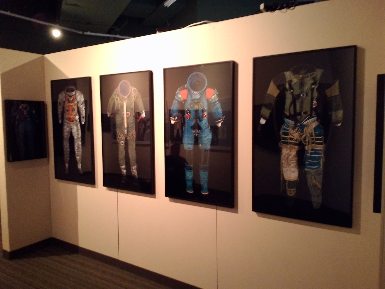
We recently had a chance to see the past, present and future of space suit technology in the Smithsonian Institutions’ touring Suited for Space exhibit currently on display at the Tampa Bay History Center in Tampa, Florida.
Tampa Bay History Center Director of Marketing Manny Leto recently gave Universe Today an exclusive look at the traveling display. If you think you know space suits, Suited for Space will show you otherwise, as well as give you a unique perspective on a familiar but often overlooked and essential piece of space hardware. And heck, it’s just plain fascinating to see the design and development of some of these earlier suits as well as videos and stills of astronauts at work – and yes, sometimes even at play – in them.
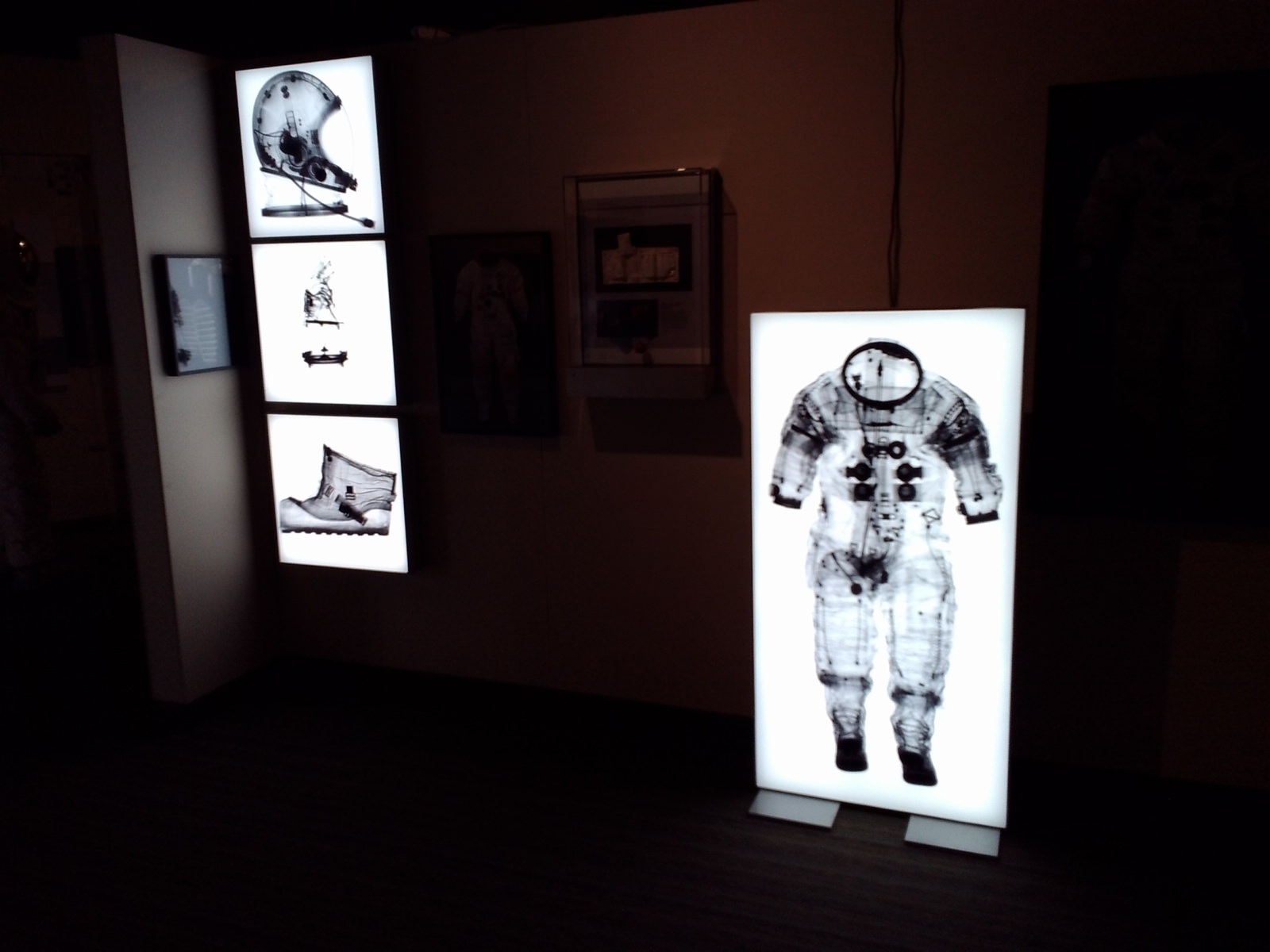
One of the highlights of the exhibit are some unique x-ray images of iconic suits from space travel history. Familiar suits become new again in these images by Smithsonian photographer Mark Avino, which includes a penetrating view of Neil Armstrong’s space suit that he wore on Apollo 11.
X-ray images of Neil Armstrong’s historic suit on display in Suited for Space. (Photo by author).
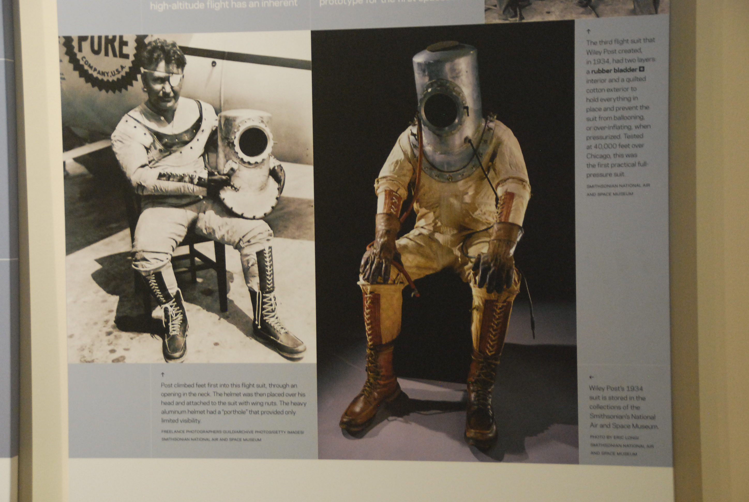
Space suits evolved from pressure suits developed for high-altitude flights in the 1950’s, and Suited for Space traces that progression. It was particularly interesting to see the depiction of Wiley Post’s 1934 suit, complete with steel cylindrical helmet and glass portal! Such early suits resembled diving bell suits of yore — think Captain Nemo in a chemsuit. Still, this antiquated contraption was the first practical full pressure suit that functioned successfully at over 13,000 metres altitude.
Wiley Post’s 1934 “rubber bladder suit.” (Photo by author).
No suit that has been into space is allowed to tour due to the fragility of many historic originals that are now kept at the Smithsonian, though several authentic suits used in training during the U.S. space program are on display. We thought it was interesting to note how the evolution of the spacesuit closely followed the development of composites and materials through the mid-20th century. You can see the progression from canvas, glass and steel in the early suits right up though the advent of the age of plastic and modern fabrics. Designs have flirted with the idea of rigid and semi-rigid suits before settling on the modern day familiar white astronaut suit.
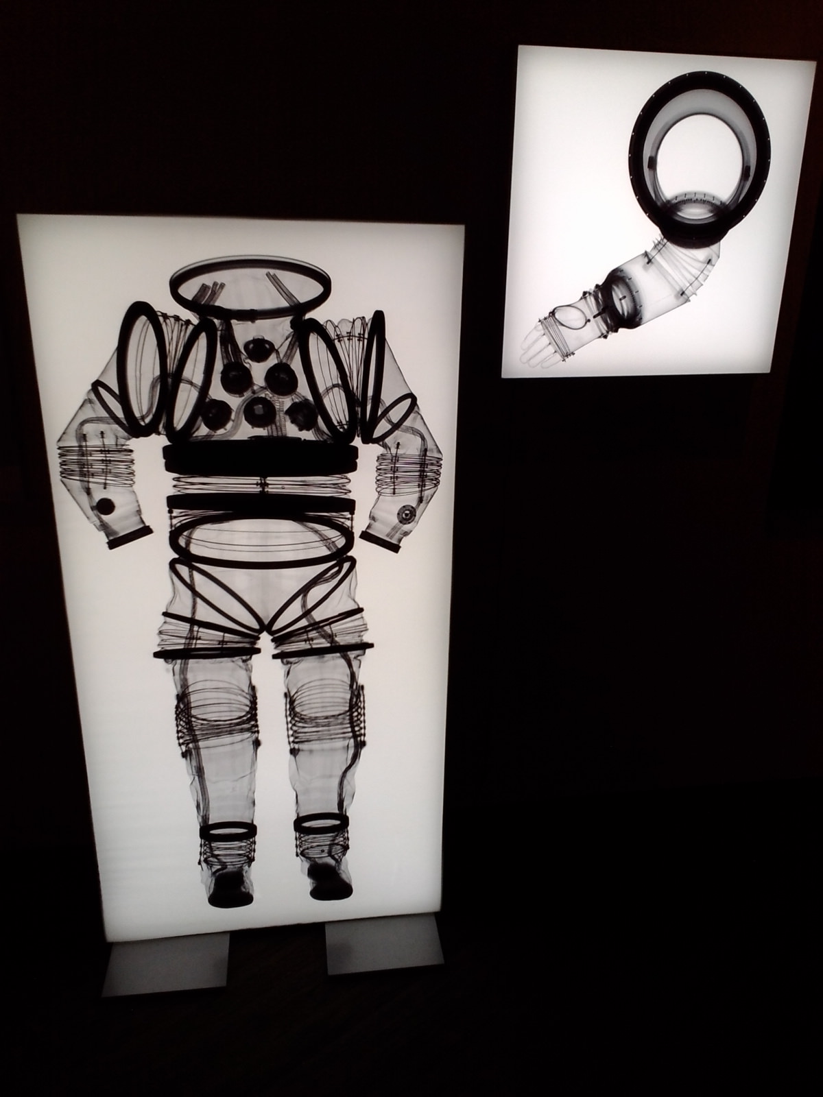
A x-ray photo of an EX-1A spacesuit. (Photo by author).
Spacesuit technology has also always faced the ultimate challenge of protecting an astronaut from the rigors of space during Extra-Vehicular Activity, or EVA.
Cosmonaut Alexey Leonov performed the first 12 minute space walk during Voskhod 2 back in 1965, and NASA astronaut Ed White became the first American to walk in space on Gemini 4 just months later. Both space walkers had issues with over-heating, and White nearly didn’t make it back into his Gemini capsule.
Early evolution of space suits on display at the Suited for Space exhibit. (Photo by author).
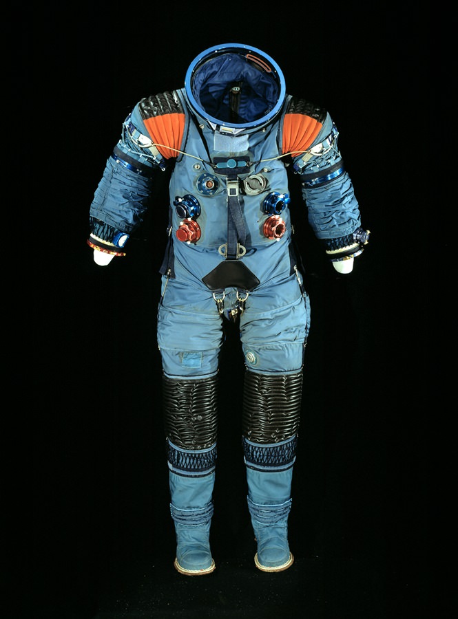
Designing a proper spacesuit was a major challenge that had to be overcome. In 1962, Playtex (yes THAT Playtex) was awarded a contract to develop the suits that astronauts would wear on the Moon. Said suits had 13 distinct layers and weighed 35 kilograms here on Earth. The Playtex industrial division eventually became known as the International Latex Corporation or ILC Dover, which still makes spacesuits for ISS crewmembers today. It’s also fascinating to see some of the alternate suits proposed, including one “bubble suit” with arms and legs (!) that was actually tested but, thankfully, was never used.
These suits were used by astronauts on the Moon, to repair Hubble, build the International Space Station and much more. Al Worden recounts performing the “most distant EVA ever” on the return from the Moon in his book Falling to Earth. This record will still stand until the proposed asteroid retrieval mission in the coming decade, which will see astronauts performing the first EVA ever in orbit around Earth’s Moon.
An A5-L Spacesuit. Credit: Smithsonian/Suited for Space.
And working in a modern spacesuit during an EVA is anything but routine. CSA Astronaut Chris Hadfield said in his recent book An Astronaut’s Guide to Life on Earth that “Spacewalking is like rock climbing, weightlifting, repairing a small engine and performing an intricate pas de deux – simultaneously, while encased in a bulky suit that’s scraping your knuckle, fingertips and collarbone raw.”
And one only has to look at the recent drama that cut ESA astronaut Luca Parmitamo’s EVA short last year to realize that your spacesuit is the only thin barrier that exists between yourself and the perils of space.
“We’re delighted to host our first Smithsonian Institution Travelling Exhibition Service (SITES) and we think that Florida’s close ties to NASA and the space program make it a great fit for us,” said Rodney Kite-Powell, the Tampa Bay History Center’s Saunders Foundation Curator of History.
Be sure to catch this fascinating exhibit coming to a city near you!
-And you can see these suits in action on the up and coming future EVAs for 2014.
-Here’s the schedule for Suited for Space Exhibit tour.
-Astronaut Nicole Stott (veteran of STS-128, -129, -133, & ISS Expeditions 20 and 21) will also be on hand at the Tampa Bay History Center on March 2014 (Date to be Announced) to present Suited for Space: An Astronaut’s View.
– Follow the Tampa Bay History Museum of Twitter as @TampaBayHistory.
NanoRacks CubeSats deployed from the International Space Station in February 2014, during Expedition 38. Credit: NASA
Astronauts fired up the International Space Station’s Yard-a-Pult (actually, we mean the Japanese Kibo arm’s satellite launcher) this week to send out a flock of Doves or tiny satellites that take pictures of the Earth below. An incredible 28 satellites from Planet Labs of San Francisco are expected to swarm into orbit — the largest fleet yet, NASA says — but there have been delays in launching some of them.
The aim? To provide Earth observation information for any purpose that is needed, whether it’s disaster relief or looking to learn more about the Earth’s environment. Planet Labs and NASA say that commercial applications could include real estate, mapping, construction and oil and gas monitoring.
Deployments of two satellites each began on Tuesday and Wednesday, but NASA noted there are “glitches” (which the agency didn’t specify) that are holding up the launch of other ones. There’s no estimated date yet for sending out the rest of the satellites.
“We believe that the democratization of information about a changing planet is the mission that we are focused on, and that, in and of itself, is going to be quite valuable for the planet,” stated Robbie Schingler, co-founder of Planet Labs.
The Japanese Kibo robotic arm on the International Space Station deploys CubeSats during February 2014. The arm was holding a Small Satellite Orbital Deployer to send out the small satellites during Expedition 38. Credit: NASA
Expedition 38’s Rick Mastracchio and Koichi Wakata both commented on the unusual launches. “Two small satellites are deployed from our launcher here on the space station. Each a little bigger than loaf of bread,” Mastracchio tweeted, while Wakata wrote, “Congratulations on the successful deploy of the satellites by the NanoRacks CubeSat Deployer and Kibo robotics!”
For more information on Flock 1, check out the Planet Labs website. You can also check out an animation of how NanoRacks CubeSats deploy in the animation below (which includes a clip from the song “We Are Young” by Fun.)
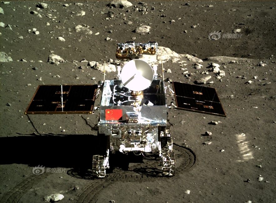
This composite view shows China’s Yutu rover heading south and away forever from the Chang’e-3 landing site about a week after the Dec. 14, 2013 touchdown at Mare Imbrium. This cropped view was taken from the 360-degree panorama. See complete 360 degree landing site panorama herein. Chang’e-3 landers extreme ultraviolet (EUV) camera is at right, antenna at left. Credit: CNSA/Chinanews/Ken Kremer/Marco Di Lorenzo – kenkremer.com. See our complete Yutu timelapse pano at NASA APOD Feb. 3, 2014: http://apod.nasa.gov/apod/ap140203.htm
The little ‘rabbit’ beloved worldwide has now phoned home and actually survived the perils of the long lunar night and is alive and awake to start a 3rd day of scientific exploration despite suffering a serious malfunction as it entered the latest hibernation period two weeks ago.
“Yutu has come back to life!” said Pei Zhaoyu, the spokesperson for China’s lunar probe program, according to a breaking news report by the state owned Xinhua news agency.
“Experts are still working to verify the causes of its mechanical control abnormality.”
The Chang’e-3 mothership lander and piggybacked Yutu surface rover soft landed on the Moon on Dec. 14, 2013 at Mare Imbrium (Sea of Rains) – marking China’s first successful spacecraft landings on an extraterrestrial body in history.
Yutu’s new lease on life also comes after Monday’s (Feb. 11) premature report of the robots demise by the state owned China News Service, reported here.
However, “Yutu failed to power-up Monday [Feb 11] and data about its current condition and repair progress is still being collected and analyzed,” Xinhua and CCTV (China state run television) reported.
This indicates that Yutu was in fact feared lost for some time by the mission team, until further efforts finally resulted in the detection of a signal from the spacecraft – and a welcome reversal of yesterdays news!
The robot “has now been restored to its normal signal reception function,” says Pei.
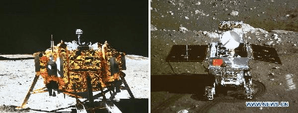
Side by side screenshot photos of the Chang’e-3 moon lander (L) and the Yutu moon rover during the mutual-photograph process, at the Beijing Aerospace Control Center in Beijing, on Dec. 15, 2013. The moon rover and the moon lander took photos of each other marking the complete success of the Chang’e-3 lunar probe mission. (Xinhua/Ding Lin)
Earlier today (Feb. 12) amateur radio operators at UHF-satcom reported detection of a signal from Yutu.
But much technical work remains ahead for the engineering and science teams to ascertain why it malfunctioned and whether the six wheeled rover can be restored to partial or full functionality.
As night fell on Jan. 25, the rover entered its second two week long period of dormancy just as the rover “experienced a mechanical control abnormality,” according to a report by China’s official government newspaper, The People’s Daily.
“Experts were initially concerned that it might not be able to survive the extremely low temperatures during the lunar night.”
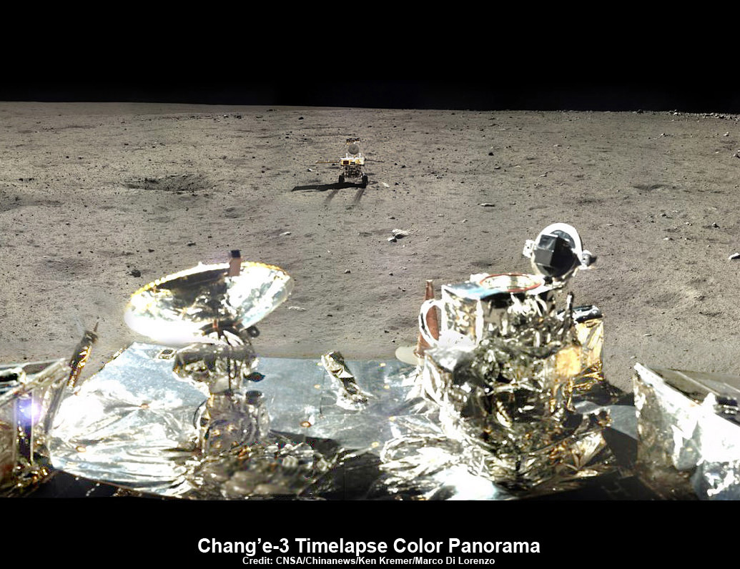
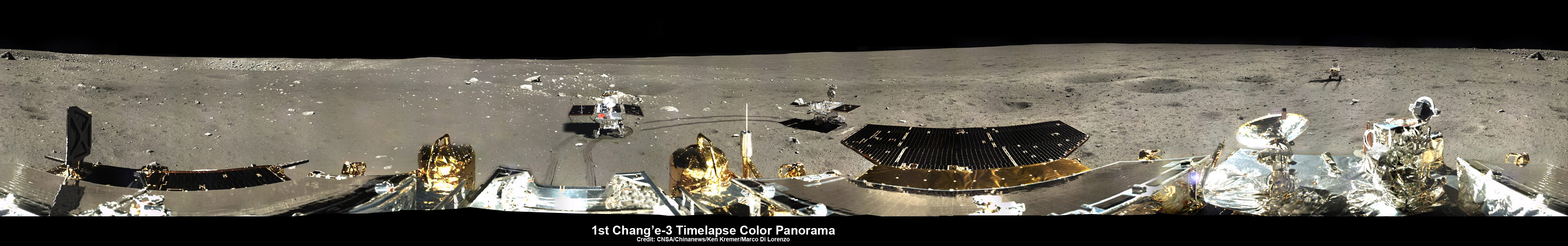
360-degree time-lapse color panorama from China’s Chang’e-3 lander
This 360-degree time-lapse color panorama from China’s Chang’e-3 lander shows the Yutu rover at three different positions during its trek over the Moon’s surface at its landing site from Dec. 15-22, 2013 during the 1st Lunar Day. Credit: CNSA/Chinanews/Ken Kremer/Marco Di Lorenzo – kenkremer.com. See our Yutu timelapse pano at NASA APOD Feb. 3, 2014: http://apod.nasa.gov/apod/ap140203.htm
Each lunar day and night lasts for alternating periods of 14 Earth days.
During each long night, the Moon’s temperatures plunge dramatically to below minus 180 Celsius, or minus 292 degrees Fahrenheit.
Both solar powered probes must enter hibernation mode during each lunar night to conserve energy and protect their science instruments and control mechanisms, computers and electronics.
“The rover stands a chance of being saved now that it is still alive,” Pei stated.
Yutu, which translates as ‘Jade Rabbit’ is named after the rabbit in Chinese mythology that lives on the Moon as a pet of the Moon goddess Chang’e.
‘Jade Rabbit’ had departed the landing site forever, and was journeying southwards as the anomoly occurred – about six weeks into its planned 3 month long moon roving expedition to investigate the moon’s surface composition and natural resources.
The 140 kg Yutu robot is located some 100 m south of the lander.
Traverse Path of Yutu rover from Dec. 14 landing to Dec. 21. Landscape textured with Chang’e 3 imagery from space and ground. Credit: CNSA/BACC
Definitive word about the Chang’e-3 lander has not yet been announced. But it is expected to survive since no malfunctions have been reported. It has a 1 year design lifetime.
Xinhua stated that Chinese space officials will comment on the landers status soon.
The 1200 kg stationary lander is expected to return science data about the Moon and conduct telescopic observations of the Earth and celestial objects for at least one year.
Chang’e-3 and Yutu landed on a thick deposit of volcanic material.
The inaugural pair of probes could be the forerunners to a manned Chinese Moon landing mission a decade from now.
China’s current plans call for the Chang’e-4 Moon lander/rover to launch in 2016, perhaps with some upgrades and lessons learned from the ongoing mission.
China is only the 3rd country in the world to successfully soft land a spacecraft on Earth’s nearest neighbor after the United States and the Soviet Union.
Stay tuned here for Ken’s continuing Chang’e-3, Orion, Orbital Sciences, SpaceX, commercial space, LADEE, Mars and more planetary and human spaceflight news.
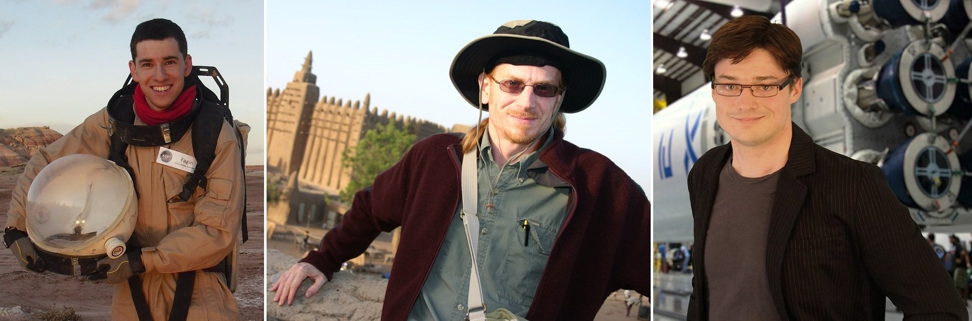
Three Mars One applicants that made it to the second round. From left, Max Fagin, Brian Hinson and Andrew Rader. (All pictures provided by the respective subjects of the photos).
If you were to find yourself on the Red Planet, what would you do when you get there? Those who made the second round of the Mars One mission (which aims to establish a colony on Mars in the next decade) are a step closer to answering that question. In interviews with Universe Today, applicants Andrew Rader, Max Fagin and Brian Hinson explained what they’ll do if they embark on a planned one-way trip to the Red Planet.
It’s impossible in three interviews to capture the diversity of more than 1,000 second-round applicants, so we encourage you to head over to Mars One’s website to browse the full list of people. As for these three would-be Marstronauts, we have their application videos and their plans for Mars exploration below the jump.
Max Fagin, 26, United States
With a resume including the NASA Academy and the Mars Desert Research Station, you’d expect that Fagin would be interested in the conventional astronaut program. He wants to try for Mars One first, however, because the Red Planet is the destination he prefers.
“Applying to become an astronaut at NASA is still an option, but at the moment they don’t have Mars as a destination,” he said. “Right now it’s the asteroids, which is cool, I’d love to see that, but it’s not something I’m willing to risk my life over.” Going to Mars would provide a greater payoff, he added, in that a new home base could be established for humanity.
One question intriguing Fagin is how to make a vehicle that travels to Mars better optimized to be used on the surface. He believes that the design will need to be changed somehow post-landing to make it possible to perform agriculture and do other duties on station. (He is in fact doing graduate engineering work at Indiana’s Purdue University right now to study more about this problem.)
Fagin is looking forward to diversifying his training if he does get selected. He’s strong in engineering, he said, but feels that learning medical skills, for example, will position all crew members well to work on the surface.
Brian Hinson, 44, United States
As you can see by the application video, Hinson is not afraid of standing out. He’s been to 39 countries and describes himself as experienced in learning about different cultures. He’s a private pilot and has also tested himself physically, for example by mountain-climbing to altitudes above 19,685 feet (6,000 meters).
“The whole Mars thing came up, and it sounds like the greatest adventure of all time,” said Hinson, who co-founded the company Skin Beautiful Dermaceuticals with his wife, Kathleen Eickholt (who is supportive of the Mars mission, but doesn’t necessarily want him to leave, he adds).
Hinson is a lifelong space enthusiast, but says his math capabilities weren’t enough to consider the NASA astronaut program. He would contribute to the mission as an engineer: “I think I could help out with hydroponics, recycle the water and everything else … [and also] picking up samples for scientists back home.”
From spending as long as 2.5 weeks on trips with strangers, Hinson added that he thinks psychological aspects will be key to success of the crew. He added that he expects the Mars One training process will include extended periods of time in isolation, perhaps something similar to the six months a science crew typically spends in Antarctica.
Andrew Rader, 34, Canada
Rader’s skills span both the technical and the human, as he earned a Ph.D. in aerospace engineering from the Massachusetts Institute of Technology and also was crowned “Canada’s Greatest Know-It-All” in a reality show competition hosted by the Discovery Channel. Mars One will only succeed as a venture if it can be “sold” to the public as a worthy endeavor, he said, adding that space enthusiasts will be among the hardest to convince because of their knowledge.
“Mars One could possibly happen if it gains enough support, if everyone donated a dollar, or space enthusiasts donated a hundred dollars [each], or billionaires donated a chunk, it could happen,” he added.
He characterizes the first few years of the colony as a time when people need to focus on the basic parts of Maslow’s hierarchy of needs. Keeping people safe and fed will come before scientific return for the first bit. His first goal on the surface will be to make the base as self-sustaining as possible. If that works out, he’d be happy to do things such as maintain rovers to pick up samples for people to analyze back at a Mars “lab”. (Having robots do surface exploration would reduce the risk of radiation, he said.)
Space is the long-term solution to the survival of our species, Rader adds, with the ultimate destination being outside the solar system. To get there first, however, you need stepping stones, and he believes Mars is the most likely destination for humans. “Mars is a very challenging place to go for us, but it is within our technological capabilities, and going there would create the technological incentives to go further.”
A week ago today, Slate published an article asking “What Is NASA for?” After the author opened the article comparing the United States’ space agency to a panda, he described a sort of loss of direction that fell upon NASA after the moon landings concluded in 1972. He then cited a litany of concerns he has about the agency, including human spaceflight scientific results not appearing in top journals, and the cost of the International Space Station.
Then Twitter space fans responded with a flurry of tweets under the hashtag #WhatIsNASAFor (3,994 tweets and retweets according to this graph cited by NASA Watch). Participants included NASA officials, journalists, industry and people who follow NASA and space exploration as a hobby. Several people also wrote essays in longer form (such as Deep Space Industries’ Rick Tumlinson, who argued the agency is in the middle of a paradigm shift). Below, we’ve collected some of the most interesting responses from Twitter.
Predicting climate change
Virginia’s Angela Gibson, who says in her profile that she has attended NASA Socials in the past, points to NASA’s ability to do scientific work to better understand climate change. She pointed to this animation of 2013’s warming trend as an example.
Scientific inquiry and the human spirit
As always, Bad Astronomy’s Phil Plait writes an eloquent essay talking about the benefits of NASA, which range from real-time observations of the Earth’s immediate environment to the longer-term goals of promoting scientific research.
NASA Socials
Frequent NASA Social attendee Charissa S. talks about the first NASA launch tweetup, STS-129, as a part of why NASA means so much to her. (Full disclosure: this article’s author also attended the tweetup as a reporter.)
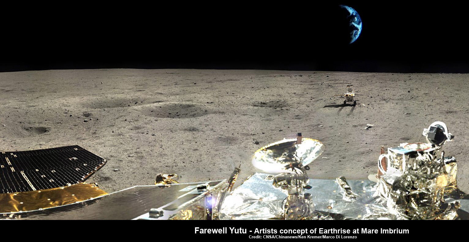
Farewell Yutu - artistic impression of Earthrise over Yutu at lunar landing site. This composite photomosaic combines farewell view of China’s Yutu rover with Moon’s surface terrain at Mare Imbrium landing site and enlarged photo of Earth, all taken by Chang’e-3 lander. Not a science image. Credit: CNSA/Chinanews/Ken Kremer/Marco Di Lorenzo – kenkremer.com
Farewell Yutu – artistic impression of Earthrise over Yutu at lunar landing site. This composite timelapse photomosaic combines farewell view of China’s Yutu rover with Moon’s surface terrain at Mare Imbrium landing site and enlarged photo of Earth – all actual images taken by Chang’e-3 lander. Not a science image. Credit: CNSA/Chinanews/Ken Kremer/Marco Di Lorenzo – kenkremer.com
See complete Yutu timelapse panorama below and at NASA APOD Feb. 3, 2014:http://apod.nasa.gov/apod/ap140203.html Story and Headline revised and updated[/caption]
Update: There might yet be hope for Yutu. Amateur radio operators at UHF-satcom reported detection of a signal from Yutu today. But no update has been reported on the China News Service website or other official state media. Yutu’s fate is unknown.]
Update 2: Yutu is alive. story and headline revised. Further details – here
………..
For a time, it seemed China’s maiden moon rover ‘Yutu’, beloved by millions worldwide, had been lost.
The apparently unfortunate and sad breaking news was just reported today in an ultra brief dispatch by the English language version of Chinadaily – with the headline “Loss of lunar rover.”
But the death notice by Chinese officials turned out to be premature when a signal was detected a day later.
It had been thought that Yutu froze to death due to a pre-hibernation mechanical malfunction and failed to wake up and communicate with China’s mission controllers in Beijing on Monday, Feb. 10, when daylight returned to the rovers Moon landing site at Mare Imbrium (Sea of Rains) at the start of what would have been Lunar Day 3 for the mission.
“China’s first lunar rover, Yutu, could not be restored to full function on Monday [Feb. 10] as expected,” wrote the state owned Chinadaily.com, China News Service agency.
The cause of the pre-hibernation malfunction may perhaps be traced back to a buildup of abrasive lunar dust, but no one knows at this time.
Note: This story has been updated as further details emerged.
Portrait photo of Yutu moon rover taken by camera on the Chang’e-3 moon lander on Dec. 15, 2013 shortly after rolling all 6 wheels onto lunar surface. Credit: Chinese Academy of Sciences
Yutu has touched the hearts of countless Earthlings since the history making landing on the desolate gray plains of the the Moon atop the Chang’e-3 lander two month ago on Dec. 14, 2013.
See our timelapse mosaic, artistic impression of Earthrise over Yutu – above – by the image processing team of Ken Kremer and Marco Di Lorenzo.
It combines real images of the Moon’s surface terrain with an intentionally enlarged photo of Earth – all snapped by the Chang’e-3 lander – as a homage to the mission.
See the complete timelapse mosaic herein and featured at NASA APOD on Feb 3, 2013.
Although definitive word about the Chang’e-3 lander has not yet been announced, it is expected to survive and has a 1 year design lifetime.
Potentially bad news about Yutu’s fate was not unexpected however, after Chinese space officials disclosed that the rover “experienced a mechanical control abnormality” two weeks ago, just as her 2nd lunar night was to begin, according to a report by China’s official government newspaper, The People’s Daily.
“Yutu experienced mechanical problems on Jan 25 and has been unable to function since then,” according to Chinadaily.com, China News service.
360-degree time-lapse color panorama from China’s Chang’e-3 lander
This 360-degree time-lapse color panorama from China’s Chang’e-3 lander shows the Yutu rover at three different positions during its trek over the Moon’s surface at its landing site from Dec. 15-22, 2013 during the 1st Lunar Day.
Credit: CNSA/Chinanews/Ken Kremer/Marco Di Lorenzo – kenkremer.com
See our Yutu timelapse pano also at NASA APOD Feb. 3, 2014:
http://apod.nasa.gov/apod/ap140203.html
The six wheeled Yutu rover and Chang’e-3 mothership lander had just finished sleeping through the terribly frigid two week long lunar night since they entered their second hibernation period on Jan. 24th and 25th respectively, and Chinese space engineers had hoped to reawaken both probes in the past few days.
No communications are possible during the period of nighttime dormancy.
This time-lapse color panorama from China’s Chang’e-3 lander shows the Yutu rover at two different positions during its trek over the Moon’s surface at its landing site from Dec. 15-18, 2013. This view was taken from the 360-degree panorama, herein. Credit: CNSA/Chinanews/Ken Kremer/Marco Di Lorenzo. See our complete Yutu timelapse pano also at NASA APOD Feb. 3, 2014: http://apod.nasa.gov/apod/ap140203.htm
Yutu, which translates as ‘Jade Rabbit’ is named after the rabbit in Chinese mythology that lives on the Moon as a pet of the Moon goddess Chang’e.
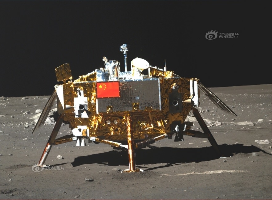
Photo of Chang’e-3 moon lander emblazoned with Chinese national flag taken by the panoramic camera on the Yutu moon rover on Dec. 22, 2013. Credit: CNSA
Apparently one of Yutu’s solar panels did not fold back properly over the instrument laden mast after it was lowered to a horizontal position into a warmed electronics box where it is shielded and insulated from the extremely frigid lunar night time temperatures.
Dust accumulation on the rover and gears may possibly be to blame for the failure to retract, based on unofficial accounts.
China has not released any official or detailed information on the cause of the malfunction or recovery actions taken by Chinese space engineers.
Such a malfunction could spell doom for the fragile electronic and computer components in the unprotected mast mounted instruments and systems, including the color and navigation cameras and the high gain antenna.
During each 14 Earth-day long night, the Moon’s temperatures plunge dramatically to below minus 180 Celsius, or minus 292 degrees Fahrenheit.
‘Jade Rabbit’ had departed the landing site forever, and was journeying southwards as the incident occurred – about six weeks into its planned 3 month long moon roving expedition to investigate the moon’s surface composition and natural resources.
The 140 kg Yutu robot drove off a pair of ramps and onto the moon seven hours after the Dec. 14, 2013 touchdown.
The 1200 kg stationary lander is expected to return science data about the Moon and telescopic observations of the Earth and celestial objects for at least one year.
Chang’e-3 and Yutu landed on a thick deposit of volcanic material.
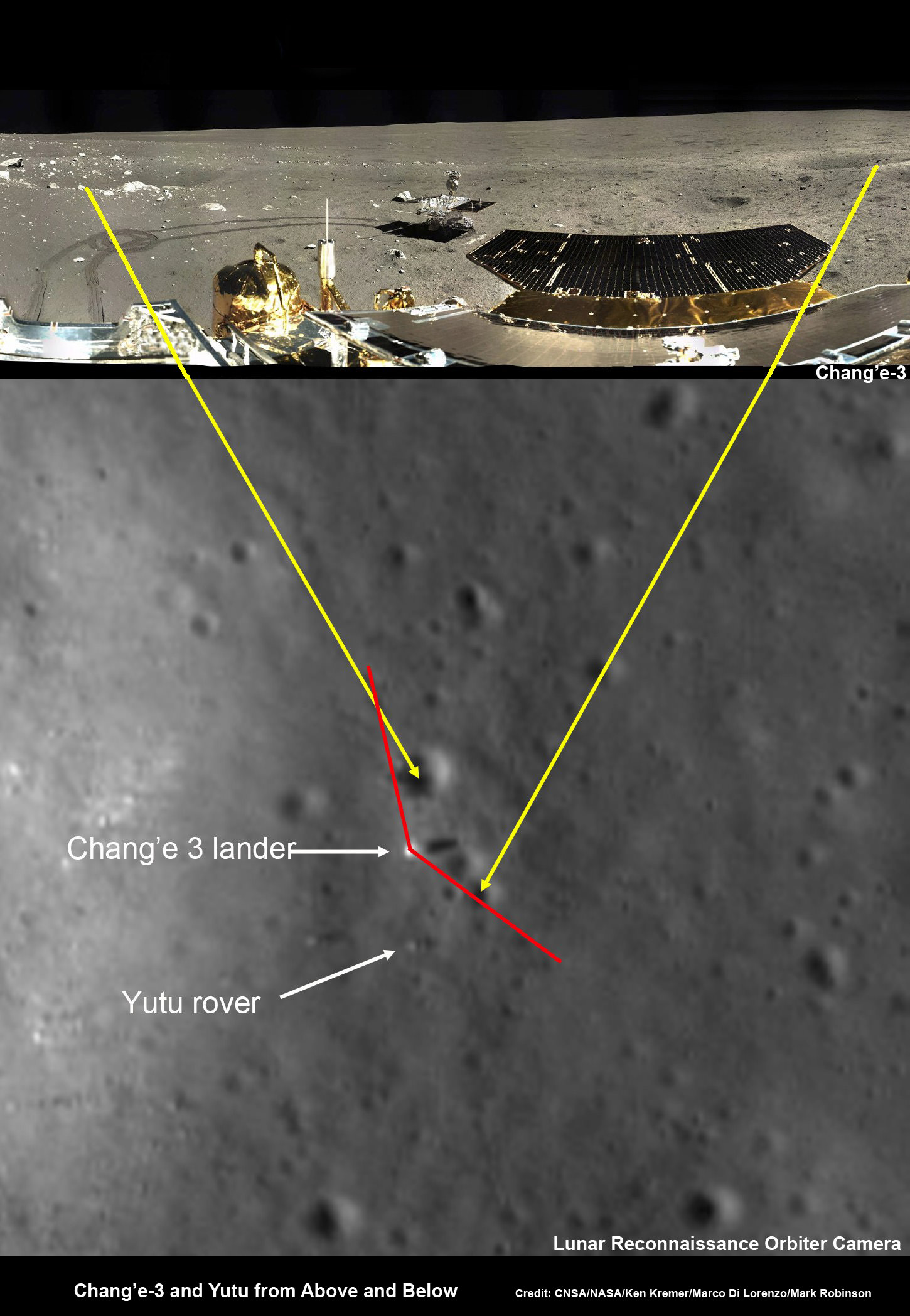
Chang’e-3 lander and Yutu rover – from Above And Below
Composite view shows China’s Chang’e-3 lander and Yutu rover from Above And Below (orbit and surface) – lander color panorama (top) and orbital view from NASA’s LRO orbiter (bottom). Chang’e-3 lander color panorama shows Yutu rover after it drove down the ramp to the moon’s surface and began driving around the landers right side to the south. Yellow lines connect craters seen in the lander panorama and the LROC image from LRO (taken at a later date after the rover had moved), red lines indicate approximate field of view of the lander panorama. Credit: CNSA/NASA/Ken Kremer/Marco Di Lorenzo/Mark Robinson
They were designed to conduct their science investigations and work independently of one another.
China can be proud of its magnificent space flight accomplishment.
Chang’e-3 was the first spacecraft from Earth to soft land on the Moon in nearly four decades since the touchdown of the Soviet Union’s Luna 24 sample return spacecraft back in 1976.
America’s last visit to the Moon’s surface occurred with the manned Apollo 17 landing mission – crewed by astronauts Gene Cernan and Harrison ‘Jack’ Schmitt , who coincidentally ascended from the lunar soil on Dec. 14, 1972 – exactly 41 years before Chang’e-3.
China’s follow on Chang’e-4 Moon lander is due to blastoff in 2015.
Surely the science and engineering team will incorporate valuable lessons learned.
China is only the 3rd country in the world to successfully soft land a spacecraft on Earth’s nearest neighbor after the United States and the Soviet Union.
Stay tuned here for Ken’s continuing Chang’e-3, Orion, Orbital Sciences, SpaceX, commercial space, LADEE, Mars and more planetary and human spaceflight news.
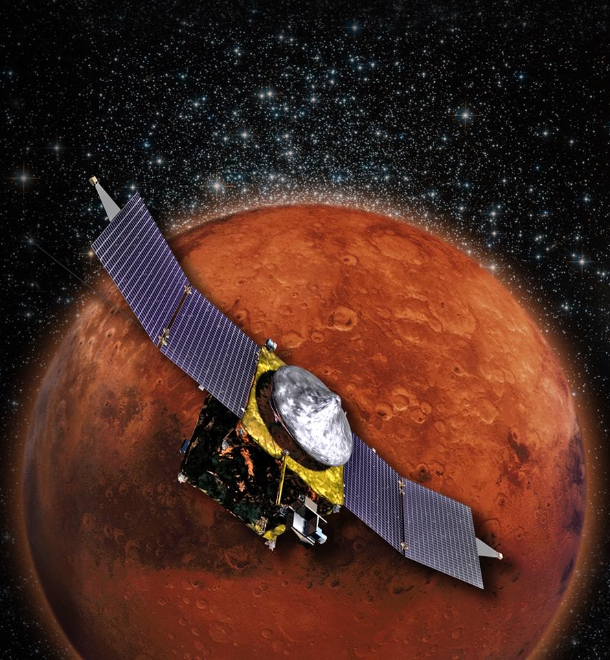
MAVEN is NASA’s next Mars Orbiter and will investigate how the planet lost most of its atmosphere and water over time. Credit: NASA
NASA’s newest Mars orbiter, the Mars Atmosphere and Volatile Evolution (MAVEN) probe passed a significant interplanetary milestone with the announcement that all of the craft’s science instruments were activated and passed their initial checkout.
“I’m delighted that we’re operating in space so well,” Bruce Jakosky, MAVEN’s Principal Investigator told Universe Today.
“We’re on our way!”
Earth is now clearly in the rear view mirror and fading with each passing day.
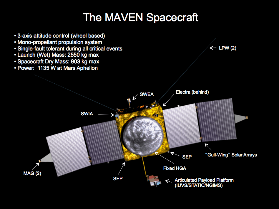
The $671 Million MAVEN spacecraft’s goal is to study Mars upper atmosphere to explore how the Red Planet may have lost its atmosphere and water over billions of years.
The MAVEN probe carries nine sensors in three instrument suites to study why and exactly when did Mars undergo the radical climatic transformation.
“I’m really looking forward to getting to Mars and starting our science!” Jakosky told me.
MAVEN aims to discover the history of water and habitability stretching back over billions of years on Mars.
It will measure current rates of atmospheric loss to determine how and when Mars lost its atmosphere and water.
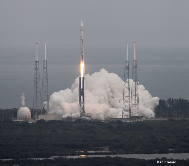
MAVEN thundered to space nearly three months ago on Nov. 18, 2013 following a flawless blastoff from Cape Canaveral Air Force Station’s Space Launch Complex 41 atop a powerful Atlas V rocket and thus began a 10 month interplanetary voyage from Earth to the Red Planet.
NASA’s Mars bound MAVEN spacecraft launches atop Atlas V booster at 1:28 p.m. EST from Space Launch Complex 41 at Cape Canaveral Air Force Station on Nov. 18, 2013. Image taken from the roof of the Vehicle Assembly Building (VAB) at NASA’s Kennedy Space Center. Credit: Ken Kremer/kenkremer.com
“I can’t tell you how exciting this is to be now only seven and a half months from getting to Mars,” Jakosky gushed.
Further instrument checkouts are planned as the orbiter streaks closer to Mars including tesating to the Electra communications package that will serve as a critical relay for NASA’s surface rovers including Curiosity, Opportunity and the planned 2020 rover.
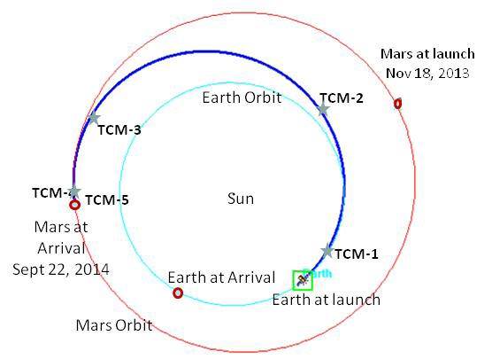
“The second Trajectory Correction Maneuver (TCM-2) is scheduled for Feb. 26,” said Jakosky.
MAVEN’s trajectory from Earth to Mars. MAVEN arrives at Mars on Sept. 22, 2014 some ten months after launch on Nov. 18, 2013. Credit: NASA
TCM thruster firings insure that the spacecraft is exactly on course for the do or die orbital insertion maneuver when MAVEN arrives on September 22, 2014.
To date MAVEN has flown over 137 million miles (221 million km) of its total 442 million miles (712 million km) path to Mars. It is speeding around the sun at 69,480 mph or 31.06 kps.
“The performance of the spacecraft and instruments to date bears out all the hard work the team put into testing the system while it was on the ground,” said David Mitchell, MAVEN project manager at NASA’s Goddard Space Flight Center in Greenbelt, Md, in a statement.
“The way that the operations team has performed while flying the system has been nothing short of outstanding. We have big events ahead of us before we can claim success but I am very pleased with how things have gone thus far.”
MAVEN is not alone in the frigid vacuum of space. She is joined by India’s Mars Orbiter Mission (MOM) orbiter in pursuit of Mars to fortify Earth’s invasion fleet.
MOM will reach Mars vicinity on Sept. 24, just two days after the arrival MAVEN on Sept. 22, 2014.
Stay tuned here for Ken’s continuing MAVEN, Curiosity, Opportunity, Chang’e-3, SpaceX, Orbital Sciences, LADEE, MOM, Mars and more planetary and human spaceflight news.
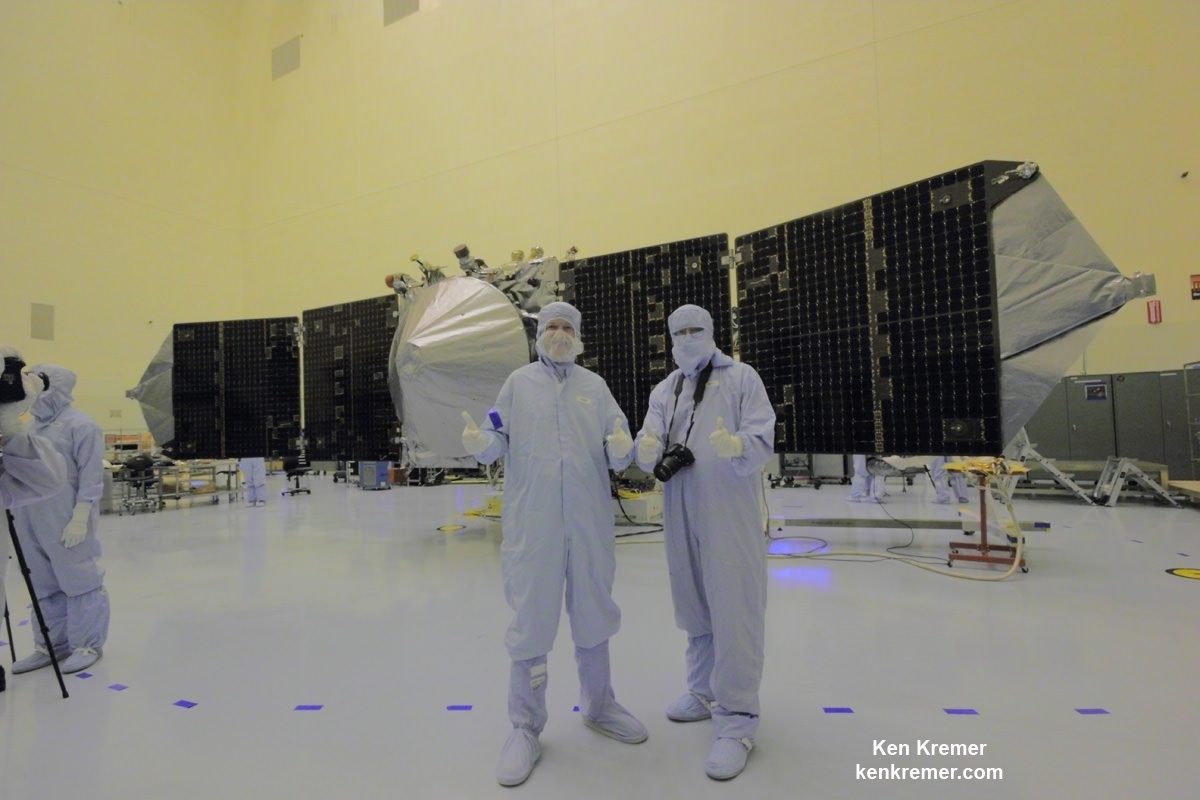
Ken Kremer NASA’s MAVEN Mars orbiter, chief scientist Prof. Bruce Jakosky of CU-Boulder and Ken Kremer of Universe Today inside the clean room at the Kennedy Space Center on Sept. 27, 2013. MAVEN launched to Mars on Nov. 18, 2013 from Florida. Credit: Ken Kremer/kenkremer.com
This composite view shows China’s Yutu rover heading south and away forever from the Chang’e-3 landing site about a week after the Dec. 14, 2013 touchdown at Mare Imbrium. This cropped view was taken from the 360-degree panorama. See complete 360 degree landing site panorama herein. Chang’e-3 landers extreme ultraviolet (EUV) camera is at right, antenna at left. Credit: CNSA/Chinanews/Ken Kremer/Marco Di Lorenzo – kenkremer.com. See our complete Yutu timelapse pano at NASA APOD Feb. 3, 2014: http://apod.nasa.gov/apod/ap140203.htm
Will Yutu Phone Home ?
This composite view shows China’s Yutu rover heading south and away forever from the Chang’e-3 landing site about a week after the Dec. 14, 2013 touchdown at Mare Imbrium. This cropped view was taken from the 360-degree timelapse panorama. See complete 360 degree landing site timelapse panorama below. Chang’e-3 landers extreme ultraviolet (EUV) camera is at right, antenna at left. Credit: CNSA/Chinanews/Ken Kremer/Marco Di Lorenzo – kenkremer.com
See our Yutu timelapse pano at NASA APOD Feb. 3, 2014:
http://apod.nasa.gov/apod/ap140203.html[/caption]
Will ‘Yutu’ phone home? Will Yutu live to see another Earthrise?
Those are the million dollar questions we’re all awaiting the answer to on pins and needles as Lunar Day 3 begins for China’s world famous ‘Yutu’ moon rover and Chang’e-3 lander, following a significant malfunction as night fell two weeks ago.
With the Sun due to rise over the Mare Imbrium landing site, China’s maiden pair of lunar probes are due to awaken at any moment now – and hopefully send good news.
Yutu – which means ‘Jade Rabbit’- and the mothership lander have been sleeping through the utterly frigid two week long lunar night since they entered their second hibernation period on Jan. 24th and 25th respectively, according to Chinese space agency officials.
To get a clear view of Yutu’s traverse across the Moon’s magnificently desolate gray plains, be sure to check out our timelapse panoramic mosaic showing the rover’s movements at three different positions around the stationary lander – above and below.
360-degree time-lapse color panorama from China’s Chang’e-3 lander
This 360-degree time-lapse color panorama from China’s Chang’e-3 lander shows the Yutu rover at three different positions during its trek over the Moon’s surface at its landing site from Dec. 15-22, 2013 during the 1st Lunar Day.
Credit: CNSA/Chinanews/Ken Kremer/Marco Di Lorenzo – kenkremer.com
See our Yutu timelapse pano at NASA APOD Feb. 3, 2014:
http://apod.nasa.gov/apod/ap140203.html
The 360 degree panorama by the imaging processing team of Ken Kremer and Marco Di Lorenzo was also newly featured on Astronomy Picture of the Day (APOD) on Feb 3, 2014.
However, as I reported earlier here, Yutu suffered a rather serious mechanical anomaly just as the sun was setting and causing China’s moon mission team to urgently sprang into action.
“Scientists are organizing repairs,” wrote the People’s Daily, the official government newspaper of China’s ruling Communist Party.
Apparently one of the solar panels did not fold back properly over Yutu’s instrument laden mast after it was lowered to the required horizontal position and into a warmed electronics box to shield and insulate it from the extremely frigid lunar night time temperatures.
The potentially deadly malfunction could spell doom for the unprotected mast mounted instruments and electronic systems, including the color and navigation cameras and the high gain antenna, if true.
Chang’e-3 lander and Yutu rover – from Above And Below Composite view shows China’s Chang’e-3 lander and Yutu rover from Above And Below (orbit and surface) – lander color panorama (top) and orbital view from NASA’s LRO orbiter (bottom). Chang’e-3 lander color panorama shows Yutu rover after it drove down the ramp to the moon’s surface and began driving around the landers right side to the south. Yellow lines connect craters seen in the lander panorama and the LROC image from LRO (taken at a later date after the rover had moved), red lines indicate approximate field of view of the lander panorama. Credit: CNSA/NASA/Ken Kremer/Marco Di Lorenzo/Mark Robinson
During each 14 Earth-day long night, the Moon’s temperatures plunge dramatically to below minus 180 Celsius, or minus 292 degrees Fahrenheit.
A radioisotopic heater unit keeps the Mast instruments warm, during lunar night, in the absence of solar power.
Dust accumulation on the rover and gears may possibly be to blame for the failure to retract, based on unofficial accounts.
China has not released any official or detailed information on the cause of the malfunction or recovery actions taken by Chinese space engineers.
So, no one knows the ‘Jade Rabbits’ fate at this time.
‘Jade Rabbit’ has been immensely popular with the Chinese public.
Over 36,000 well wishes were posted on an unofficial Sina Weibo account shortly after word of the mechanical anomaly was announced.
Lunar Day 3 at Mare Imbrium was due to start around this past weekend Feb. 8 or 9.
Traverse Path of Yutu rover from Dec. 14 landing to Dec. 21, 2013. Landscape textured with Chang’e 3 imagery from space and ground. Credit: CNSA/BACC
An anonymous writer on Weibo, China’s twitter equivalent, reported; “We will hopefully get back news of the rabbit after sunrise today February 10 at 15:00 hrs (3 pm), Beijing local time, and confirm whether safe or unable to move.” That is according to a google translation I used.
Both vehicles depend on their life giving solar panels to produce power in order to function and accomplish their scientific tasks during each Lunar day which lasts approximately 14 days.
They had been functioning perfectly and collecting science measurement as planned during Lunar Day 2.
‘Jade Rabbit’ had departed the landing site forever, and was journeying southwards as the incident occurred – about six weeks into its planned 3 month long moon roving expedition.
In a historic feat for China, the Chang’e-3 spacecraft safely touched down on the Moon at Mare Imbrium near the Bay of Rainbows some two months ago on Dec. 14, 2013 .
Seven hours later, the piggybacked 140 kg Yutu robot drove off a pair of ramps, onto the Moon and into the history books.
The 1200 kg stationary lander is expected to return science data about the Moon and telescopic observations of the Earth and celestial objects for at least one year.
Chang’e-3 and Yutu landed on a thick deposit of volcanic material.
The hugely popular probes could be the forerunners to a manned Chinese Moon landing mission a decade from now.
China is only the 3rd country in the world to successfully soft land a spacecraft on Earth’s nearest neighbor after the United States and the Soviet Union.
Stay tuned here for Ken’s continuing Chang’e-3, Orion, Orbital Sciences, SpaceX, commercial space, LADEE, Mars and more planetary and human spaceflight news.
Photo of Chang’e-3 moon lander emblazoned with Chinese national flag taken by the panoramic camera on the Yutu moon rover on Dec. 22, 2013. Credit: CNSA
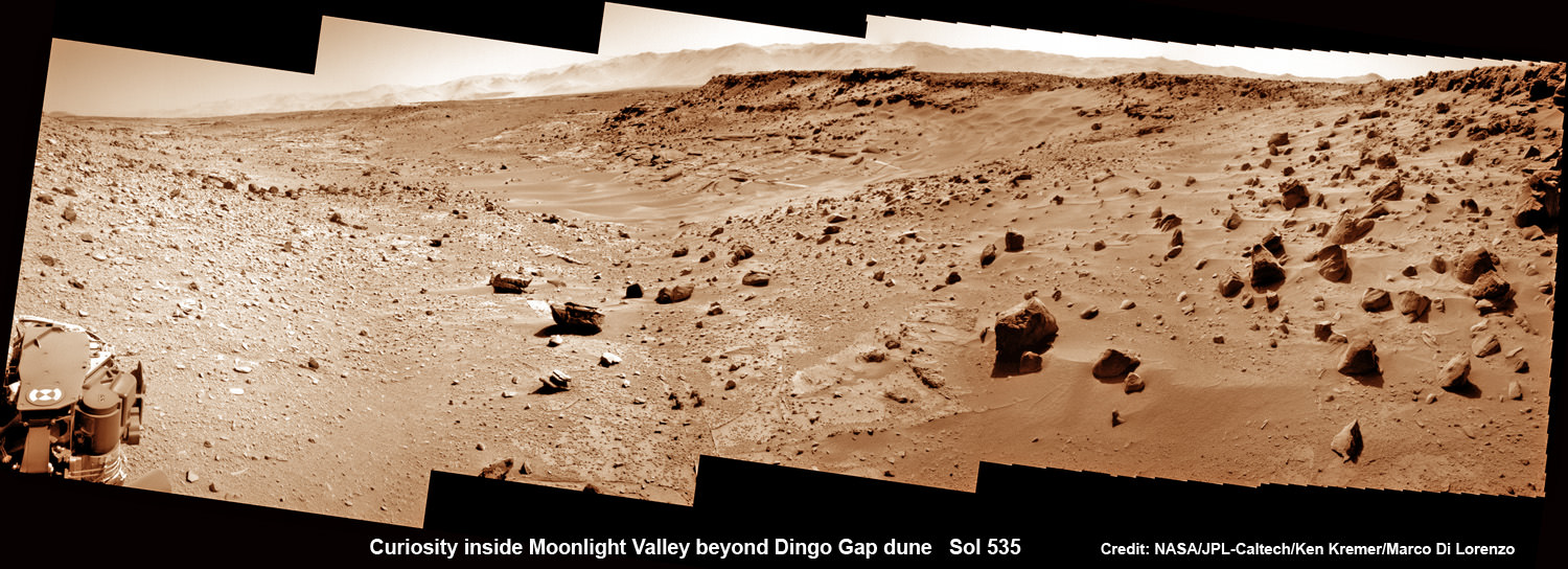
Curiosity scans Moonlight Valley beyond Dingo Gap Dune. Curiosity’s view to “Moonlight Valley” beyond after crossing over ‘Dingo Gap’ sand dune. This photomosaic was taken after Curiosity drove over the 1 meter tall Dingo Gap sand dune and shows dramatic scenery in the valley beyond, back dropped by eroded rim of Gale Crater. Assembled from navigation camera (navcam) raw images from Sol 535 (Feb. 6, 2104) Credit: NASA/JPL-Caltech/Ken Kremer- kenkremer.com/Marco Di Lorenzo
Curiosity scans Moonlight Valley beyond Dingo Gap Dune.
Curiosity’s view to “Moonlight Valley” beyond after crossing over ‘Dingo Gap’ sand dune. This photomosaic was taken after Curiosity drove over the 1 meter tall Dingo Gap sand dune and shows dramatic scenery in the valley beyond, back dropped by eroded rim of Gale Crater. Assembled from navigation camera (navcam) raw images from Sol 535 (Feb. 6, 2104) Credit: NASA/JPL-Caltech/Ken Kremer- kenkremer.com/Marco Di Lorenzo
See below more before/after Dingo Gap imagery
Story updated[/caption]
NASA’s Curiosity mega rover has successfully crossed over the ‘Dingo Gap’ sand dune- opening the gateway to the science rich targets in the “Moonlight Valley” and Martian mountain beyond.
“I’m over the moon that I’m over the dune! I successfully crossed the “Dingo Gap” sand dune on Mars,” Curiosity tweeted overnight Thursday.
“Moonlight Valley” is the name of the breathtaking new locale beyond Dingo, Curiosity Principal Investigator John Grotzinger, of Caltech, told Universe Today.
Curiosity drove westward over the 1 meter ( 3 foot) tall Dingo Gap dune in stellar style on Thursday, Feb. 6, on Sol 535.
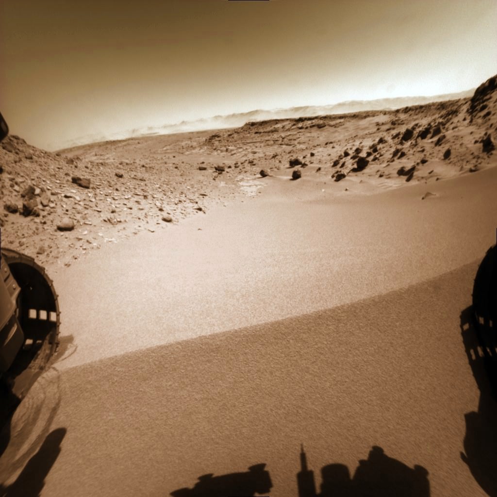
Curiosity looks back to ‘Dingo Gap’ sand dune after crossing over, backdropped by Mount Sharp on Sol 535, Feb. 5, 2014. Hazcam fisheye image linearized and colorized. Credit: NASA/JPL/Marco Di Lorenzo/Ken Kremer- kenkremer.com
Dramatic before and after photos reveal that the rover passed over the Red Planet dune without difficulty. They also show some interesting veins and mineral fractures are visible in the vicinity just ahead.
“Moonlight Valley has got lots of veins cutting through it,” Grotzinger told me.
“We’re seeing recessive bedrock.”
The Martian dune lies between two low scarps sitting at the north and south ends.
“The rover successfully traversed the dune in Dingo Gap,” wrote science team member Ken Herkenhoff in an update.
“The data look good.”
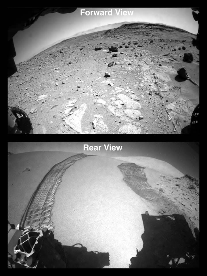
Curiosity Crosses ‘Dingo Gap’ sand dune – Looking forward and back on Sol 535. Hazcam camera images. Credit: NASA
Since arriving at the picturesque “Dingo Gap” sand dune about a week ago, Curiosity’s handlers had pondered whether to breach the dune as an alternate pathway into the smoother terrain of the valley beyond as a work around to avoid fields of rough rocks that have been ripping holes into the robots six aluminum wheels in recent months.
“We’re guessing it will be softer on the wheels,” Grotzinger informed me.
Before giving the go ahead to move forward, engineers took a few days to carefully assess the dune’s integrity and physical characteristics with the rovers science instruments and cameras to insure there wasn’t the potential to get irretrievably stuck in a deep sand trap.
The team even commanded Curiosity to carry out a toe dip by gently rolling the 20 inch (50 cm) diameter wheels back and forth over the crest on Tuesday, Feb. 4 to insure it was safe to mount.
They won’t take any chances with safety, recalling that rover Spirit’s demise occurred when she because mired in a hidden sand trap in 2010 from which there was ultimately no escape. She froze to death during the bitter Martin winter – more than 6 years into her 90 day mission.
Opportunity also got wedged at the seemingly endless dune field at “Purgatory Dune”, that nearly doomed her early in the now decade long trek. Engineers spent weeks on the extrication effort.
Curiosity does a “toe dip” wheel motion test at Dingo Gap sand dune on Sol 534, Feb 5, 2014 before crossing dune on Sol 535. Hazcam image linearized and colorized. Credit: NASA/JPL/Marco Di Lorenzo/Ken Kremer- kenkremer.com
Since last summer, Curiosity has been traveling on a southwestward route to the breathtaking foothills of Mount Sharp, her ultimate science destination.
The westward route though Dingo will soon lead Curiosity to a spot dubbed “KMS-9” where the team hopes to conduct the first rock drilling operations since departing the Yellowknife Bay quadrant in July 2013, into areas of intriguing bedrock.
“At KMS-9, we see three terrain types exposed and a relatively dust-free surface,” said science team collaborator Katie Stack of the California Institute of Technology, Pasadena.
The missions science focus has shifted to “search for that subset of habitable environments which also preserves organic carbon,” says Curiosity Principal Investigator John Grotzinger, of the California Institute of Technology in Pasadena.
But first, with the dune now safely in the rear view mirror, the team plans a busy weekend of research activities.
A big science program using the X-Ray spectrometer and high resolution MAHLI camera on the robotic arm is already planned for this weekend.
“The arm will be deployed to investigate some interesting veins or minerals filling fractures in front of the rover,” says Herkenhoff.
“ChemCam will search for frost early on the morning of Sol 538 (Saturday), then analyze targets Collett and Mussell along the vein/fracture fill later in the day.”
Thereafter Curiosity will continue on its journey across the floor of Gale Crater, taking images and atmospheric measurements along the way to the sedimentary layers at the base of Mount Sharp.
Curiosity has already accomplished her primary goal of discovering a habitable zone on Mars that could support Martian microbes if they ever existed.
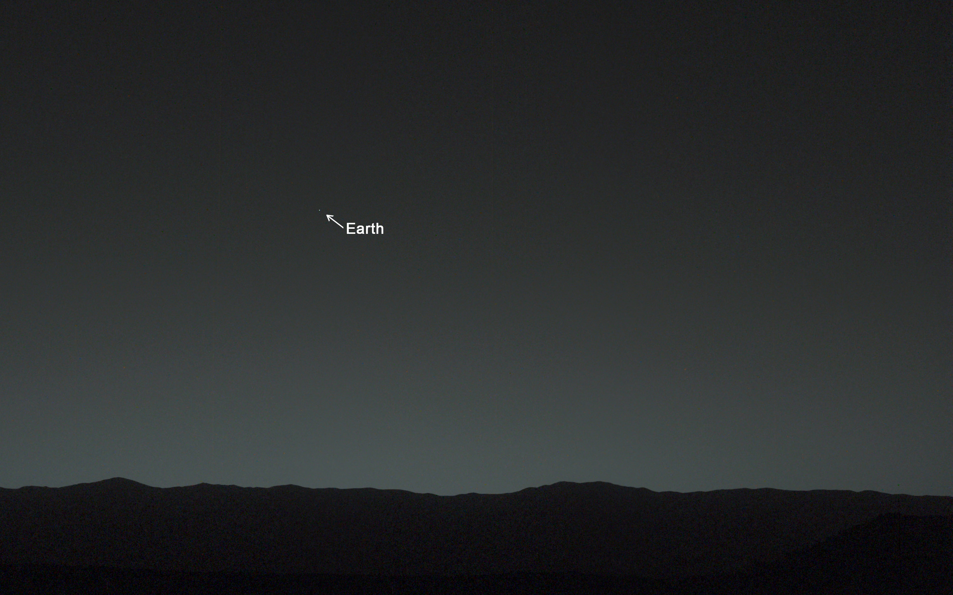
And be sure to check out Curiosity’s first ever image of Earth from Mars in my new story – here.
To date Curiosity’s odometer stands at nearly 5 kilometers and she has taken over 118,000 images.
The robot has about another 5 km to go to reach Mount Sharp.
Stay tuned here for Ken’s continuing Curiosity, Opportunity, Chang’e-3, SpaceX, Orbital Sciences, LADEE, MAVEN, MOM, Mars and more planetary and human spaceflight news.
You are here! As an Evening Star in the Martian Sky
This evening-sky view taken by NASA’s Mars rover Curiosity shows the Earth and Earth’s moon as seen on Jan. 31, 2014, or Sol 529 shortly after sunset at the Dingo Gap inside Gale Crater. Credit: NASA/JPL-Caltech/MSSS/TAMUCuriosity’s View Past Tall Dune at edge of ‘Dingo Gap’
This photomosaic from Curiosity’s Navigation Camera (Navcam) taken at the edge of the entrance to the Dingo Gap shows a 3 foot (1 meter) tall dune and valley terrain beyond to the west, all dramatically back dropped by eroded rim of Gale Crater. View from the rover’s overlook position on Sol 528 (Jan. 30, 2014). The rover team has now commanded Curiosity to bridge the dune gap as a smoother path to next science destination. Credit: NASA/JPL-Caltech/Marco Di Lorenzo/Ken Kremer- kenkremer.comUp close view of hole in one of rover Curiosity’s six wheels caused by recent driving over rough Martian rocks. Mosaic assembled from Mastcam raw images taken on Dec. 22, 2013 (Sol 490). Credit: NASA/JPL/MSSS/Ken Kremer – kenkremer.com/Marco Di Lorenzo