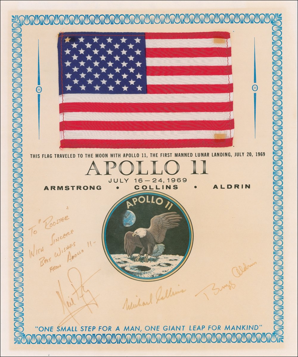
This flag flew to the Moon and back with the Apollo 11 crew. It's one of the many items from the history of spaceflight up for sale at an upcoming auction. Image Credit: RR Auction
[/caption]
If you’re interested in owning an artifact or two from the history of spaceflight, now could be your chance to snag some up. From January 13-20, over 400 artifacts relating to the history of spaceflight will be up on the auction block at RR Auction. There’s a diverse number of different pieces, ranging from an Atlas I and II crow’s foot wrench to numerous items that flew aboard many of the Apollo missions and on Projects Mercury and Gemini.
There are even a few spare parts for the Shuttle, though it’s probably not a good idea to follow along in Johnny Cash’s footsteps; if you build a space shuttle one piece at a time, it’ll cost you more than a dime and I doubt you’ll want to fly it into space.
This auction is filled with loads of memorabilia – much of it signed by astronauts or other NASA personnel – from the Apollo missions. There is a US flag that flew with the Apollo 11 crew to the Moon and back, attached to a certificate signed by Armstrong, Aldrin and Collins. As you can imagine, this one is going to go for a lot – the bidding starts at $2500. If you drill it out so it'll fit, and with a little help from an A-daptor kit, you could have a shuttle running just like a song. Image Credit: RR Auction. Mangled lyrics credit: The Man in Black
One piece that has been getting a lot of attention – and will probably also sell for quite a lot, given that it starts out at $1000 – is the original page from the November 1969 Playboy magazine featuring topless Playmate DeDe Lind. The page was stuck to a piece of cardboard aboard Apollo 12, and traveled all the way to the Moon and back aboard the Yankee Clipper.
It’s accompanied by a certificate of authenticity from Richard Gordon, the Apollo 12 Command Module pilot, which reads in part: “This cue card, which flew with me to the moon, has been in my sole possession and part of my personal space collection since my return from the moon in 1969 aboard America’s second lunar landing mission, and it remains one of the all-time greatest Apollo era astronaut ‘Gotcha’s!’” Historic, indeed.
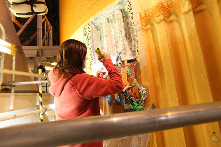
A technician begins to remove thermal sensors and foam insulation from space shuttle Discovery's external fuel tank in the Vehicle Assembly Building. Photo Credit: NASA/Frank Michaux
[/caption]
Discovery’s woes deepened this week with NASA engineers finding even more cracks in the orbiter’s external tank. The first crack was noted shortly after a leak was discovered on the Ground Umbilical Carrier Plate (GUCP) Nov. 5. After the first crack was found, technicians found a second and then a third. NASA found the crack on support beams dubbed ‘stringers’ around the intertank region of the tank. They applied what is known in the business as a doubler, a section of metal that is twice as thick as the original – this is done to strengthen the affected area.
On Dec. 17, a tanking test was conducted on the tank. Some 89 instruments were attached to the outside to monitor the tank as it was filled with super-cold liquid oxygen and hydrogen. The external tank can shrink by as much as an inch when these extremely cold liquids enter the tank. As one might imagine, this creates great stress on the tank, as such mission managers had the orbiter rolled back into the Vehicle Assembly Building (VAB) for X-Ray scans and other tests.
These tests are considered to be ‘non-destructive’ but NASA is not able to conduct them out at launch complex 39A. Testing started as soon as the full stack consisting of the orbiter, ET and twin solid rocket boosters were in the VAB.
It is unknown when Discovery will be back at LC39A for her final mission, STS-133. Photo Credit: Alan Walters/awaltersphoto.com
However, once these scans were completed – NASA had more problems, more cracks were found. Four cracks were found hiding beneath the foam on the side of the ET that faces away from Discovery. Mission managers will now weigh whether-or-not they will go ahead with repairing the damaged section of the ET. They are scheduled to make a final determination on Monday, Jan. 3. If they elect to do so, the repairs will be conducted inside of the VAB and not out at the pad.
STS-133 is a resupply flight to the International Space Station (ISS). When it does launch, it will carry the modified Leonardo Permanent Multipurpose Module (PMM) to the orbiting outpost. Contained within that is the first human-like robot to fly into space – Robonaut-2 (R2). Currently, Discovery is scheduled to launch no-earlier-than Feb. 3 at 1:37 EDT. This mission will mark the 39th time that Discovery has taken to the Florida skies and will be the final scheduled mission in the orbiter’s career.
Discovery's final crew may have to wait a while longer before they can start their mission. Image Credit: NASA
From Russia, with love. Here’s a video put together by Roscosmos of launch and mission highlights. Interestingly, in 2010, Russia has made almost a half of all launches in the world – 31 launches of 74. Next was the USA and China with 15 launches each. ESA sent 6 rockets to space, India had 3, South Korea had 1, Japan 2, and Israel 1. Four launches in the world were unsuccessful.
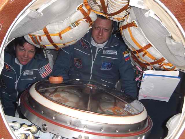
Astronaut Cady Coleman and cosmonaut Dmitry Kondratyev inside the living area of the Soyuz TMA-20. Credit: Roscosmos.
[/caption]
Cosmonaut Dmitry Kondratyev recently arrived at the International Space Station, along with astronauts Cady Colemand from the US and Paolo Nespoli from the European Space Agency. Kondratyev has a blog, which he has been updating regularly and he has included several pictures. Most interestingly, he has quite a few images taken inside the Soyuz after launch as the crew was on their way to meet up with the ISS. Very few interior images of the Soyuz during flight have been made available before. Below are some that Kondratyev shared.
Dmitry Kondratyev inside the Soyzu either before or during launch. Credit: Roscosmos
Still feeling the effects of gravity, Kondratyev looks buried among all the supplies stuffed into the Soyuz.
The weightlessness from being orbit seems to provide more room inside the Soyuz. Credit: Roscosmos. Coleman and a checklist feel the effects of weightlessness. Credit: Roscosmos.After reaching orbit and checking all systems, the crew took off their launch suits and dressed in more comfortable flight suits. Credit: Roscosmos.Coleman and Nespoli stretch out in the Soyuz living area and grab a bite to eat. Credit: RoscosmosThe view of Earth from the Soyuz TMA-20. Credit: Roscosmos. Kondratyev and Coleman inside the Soyuz living area. Credit: Roscosmos
Kondratyev wrote in his blog: “For two days we had two hours of relaxation for sleep. Sleeping crew members are able to choose any convenient location and arbitrary orientation in space. At other times, we learned to eat in weightlessness, Earth watched and talked with TsUPom, check the efficiency of vehicle systems.”
Sleeping arrangements on the Soyuz. Credit: Roscosmos.
See more images and read about life on the ISS at Kondratyev’s blog.
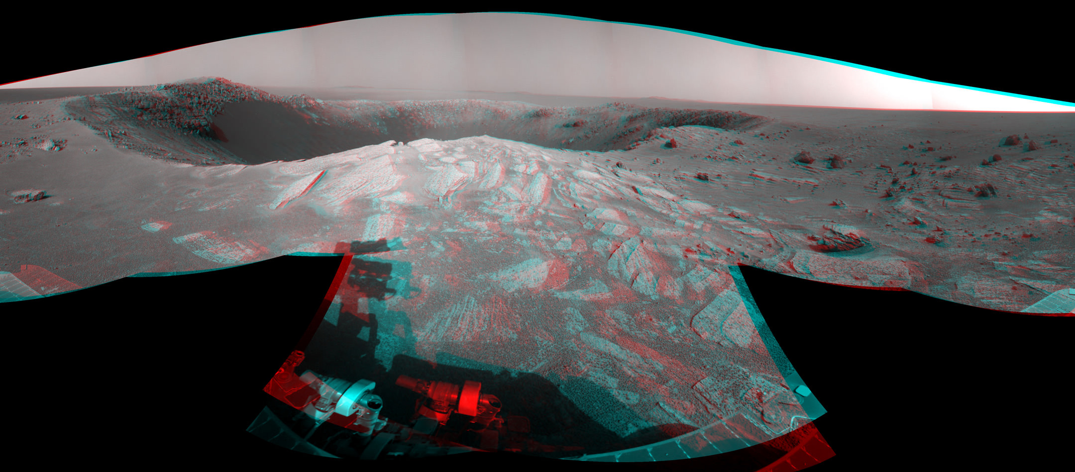
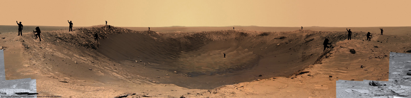
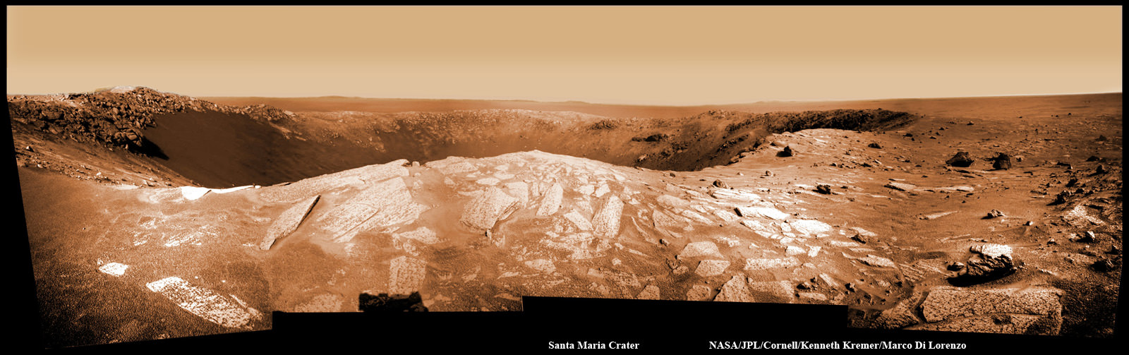
Santa Maria is a football-field-size crater - about 90 m wide and 12 m deep - which dominates the scene in this stereo view from NASA's Opportunity rover. Opportunity sits about 5 meters from the steep western edge of this scientifically interesting impact crater which displays signatures of water bearing minerals at the center of this mosaic. Opportunity arrived here following a 25-meter (82-foot) drive on the 2,451st Martian day, or sol, of the rover's work on Mars (Dec. 16, 2010). The rover used its navigation camera to take the frames combined into this mosaic. The scene appears three-dimensional when viewed through red-blue glasses with the red lens on the left. It combines images taken with the left eye and right eye of the navigation camera. Credit: NASA/JPL/Cornell.
[/caption]
Spectacular new images of a gorgeous gaping hole on Mars are streaming back to Earth from NASA’s Opportunity Mars Rover. So let’s take a 3 D stroll placing all of us at Santa Maria Crater – “On Mars”. Via the photo mosaics above and below, we will circle in three dimensions about the stunningly beautiful Santa Maria Crater. At the southeast portion of the rim, the crater also possesses a scientific goldmine of hydrated mineral deposits. These minerals are indicative of the past flow of liquid water on Mars, an essential requirement for the formation of life.
Opportunity made landfall at the western edge of Santa Maria on Dec. 15 (Sol 2450) after a long and arduous journey of some 19 km since departing from Victoria Crater over 2 years ago in September 2008. She crawled closer to the rim the next day on Dec. 16 (Sol 2451) unveiling a magnificent vista of jumbled ejecta rocks, steep sloped cliffs and undulating sand dunes across the crater floor.
“Santa Maria is a relatively fresh impact crater. It’s geologically very young, hardly eroded at all, and hard to date quantitatively. On the order of 10 million years old or less,” said Ray Arvidson in an interview from Washington University in St. Louis. Arvidson is the deputy principal investigator for the Spirit and Opportunity rovers.
Santa Maria from Palos Promontory on Mars.
Imagine yourself at the steep cliff walls of Santa Maria crater at a place called Palos. To get a sense of scale in 2 D, human sized figures (2 m tall) have been strategically placed at multiple locations near and far, around and inside this gorgeous panoramic vista. Opportunity drove closer and snapped these images just 2.5 meters from the crater’s edge on Sols 2453 & 2454. Mosaic Credit: NASA/JPL/Cornell, James Canvin. Annotations of Mysterious men in black hats and their cousins, the French climbers by FredK and ElkDanGrove at unmannedspaceflight.com
“Santa Maria is the freshest big guy that Opportunity has seen and has a raised rim,” Arvidson told me. “It is much younger than Endurance Crater which Opportunity visited a few months after landing on Mars way back in 2004 and is roughly the same diameter.” See the entire Opportunity traverse map below.
“The crater is young enough that the interesting hydrate outcrops may not be coated with the nanophase iron oxide dust. There is virtually no erosion. We can see the ejecta rays and blocks,“ said Arvidson.
While sitting just five meters from the rim on Dec. 16, Opportunity imaged the football field sized crater – some 90 m wide – with both its left and right eye navigation cameras. A mosaic of these images was stitched together by NASA to create a stunning 360 degree stereo panoramic vista. The images are snapped from the same height seen by an adult to give the perspective that a human eye would see when standing “On Mars”.
The crater is the centerpiece of the stereo image above, which shows the crater’s sharp rim and rocks ejected from the impact that had excavated the crater. You will need to whip out your red-cyan stereo glasses to experience the full three-dimensional effect of the scene. Be sure to wear the red lens on the left, and try not to fall off the cliff.
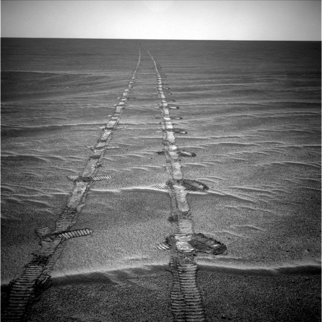
Click here for the entire 360-degree high resolution stereo view – its 10 MB in all. South is at the center. North is at both ends. The view is presented as a cylindrical-perspective projection. The wheel tracks left behind in the Martian dirt – as the rover approached the crater – are seen at the far right and are also highlighted in our 2 D mosaic below.
Off in the distance, several portions of the rim of Endeavour Crater are visible as bumps on the horizon. Endeavour is the ultimate target of Opportunity’s long term trek across the Martian dunes at the Meridiani Planum region and is some 22 kilometers in diameter.
“Endeavour shows significant signatures of phylloslicates, or clay minerals, and water bearing sulfate minerals which formed in the presence of liquid water,” Arvidson explained. “The phyllosilicates formed at the crater rim about 3.8 to 4.2 Billion years ago and predate the sedimentary rocks which are younger than 3.8 billion years.”
Pictured below is a collection of stereo photo mosaics for a North to South up close tour around the rim of Santa Maria. Several of the images were created by members of unmannedspaceflight.com.
“Opportunity will drive in a counterclockwise direction around Santa Maria to reach the very interesting hydrated sulfates on the other side. We’ll make 3 stops or more depending on what we see”
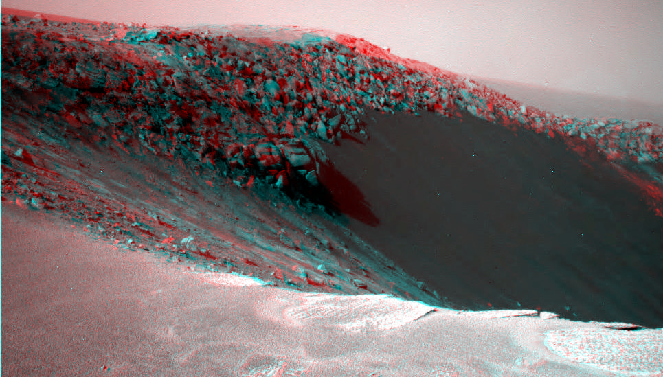
Stereo view of the sharp northern rim of Santa Maria on Sol 2451. Credit: NASA/JPL/Cornell/Stu AtkinsonConvoluted martian rocks in 3 D close up at the sharp northern rim of Santa Maria. Credit: NASA/JPL/Cornell/Walfy at unmannedspaceflight.com
“On Dec. 19 (Sol 2454) we bumped the vehicle even closer to the rim from the initial approach point, to a promontory we’ve nicknamed ‘Palos’, stated Arvidson. “Opportunity was a mere 2.5 meters from the edge. At ‘Palos’, the rover collected the first set of long baseline, high resolution stereo images for creating a 3 D digital elevation map.”
“The coves at Santa Maria will be named after the islands which Columbus visited, using the native American language. All the rocks and boulders strewn about will be named after the sailors on the voyage with Columbus,” explained Arvidson.
“This past weekend we drove about 20 meters southeast towards the second location named ‘Wanahani’. On Tuesday of this week (Dec. 28) we bumped to the edge. The plan is to photograph the ejecta rocks and collect the next set of long baseline, high resolution stereo images.”
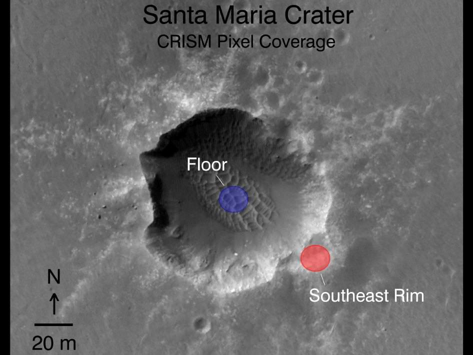
The third stop – which must be reached before Solar Conjunction in mid January 2011- will take Opportunity to the science hot spot detected by the powerful CRISM mineral mapping spectrometer circling above Mars aboard NASA’s Mars Reconnaissance Orbiter (MRO).
“With CRISM we are trying to cover all the rim segments to better understand the nature and geologic setting of the iron and magnesium smectite clay mineral exposures. The southeast portion of Santa Maria is generally the location of the CRISM spectra that show hydrated sulfates. Opportunity will go to the southeast rim and try and find a nice outcrop on the rim side to do measurements to field verify the expected mineralogy,” explained Arvidson.
“We might do a toe dip with the wheels but there is no plan to go inside.”
“We will use the Rock Abrasion Tool (RAT) to drill into a selected target. That spot will be named after ‘Columbus’.
The exposures of hydrated sulfates have a bright toned appearence in the images.
“With the sun over the camera’s shoulder there is a phenomenon called opposition effect in which rocks and soils become particularly bright when the sun-camera-surface line up, Arvidson told me. “But, it also may be that the bright looking rocks are intrinsically bright and not coated with the nanophase iron oxide coatings we have seen on previous outcrops. All in the realm of testable working hypotheses.”
“On Dec. 30 we are planning another CRISM spectral mapping campaign with MRO over Santa Maria,” said Arvidson. “Using a new technique which gimbals, or swivels, the CRISM optics we hope to use a pixel overlap technique to improve the ground resolution from 18 meters across to 6 meters across. This data will be used in tactical decisions about where to drive on Mars.”
Read more of my interview with Ray Arvidson in the next feature story describing the exciting plan for science exploration at Santa Maria and Endeavour, the outlook for Spirit and more – along with new mosaics from “Wanahani”.
Hydrated Sulfates in 3 D at Santa Maria.
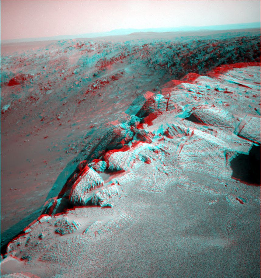
This cropped 3 D segment shows the location of the bright toned exposures of hydrated sulfate minerals detected inside the southeast rim of the steep walled crater. Deposits of hydrated sulfates are an indicator of the past flow of liquid water on Mars. They were detected from orbit by the CRISM mapping spectrometer aboard NASA’s Mars Reconnaissance Orbiter (MRO). Opportunity will go to the SE rim and try to do measurements to field verify the expected mineralogy. Credit: NASA/JPL/CornellLooking in stereo to the steep walled southern rim of Santa Maria.
Opportunity will drive to the south rim in January 2011. Cape Tribulation is in the background and located at the western rim of the huge Endeavour Crater which possesses deposits of clay minerals, or phyllosilicates, which form in the presence of neutral liquid water. Cape Tribulation is about 100 meters tall. Credit: NASA/JPL/Cornell/NickF at unmannedspaceflight.com‘Crocodile Tail’ in 3D.
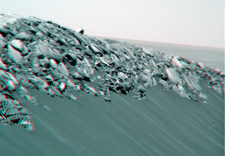
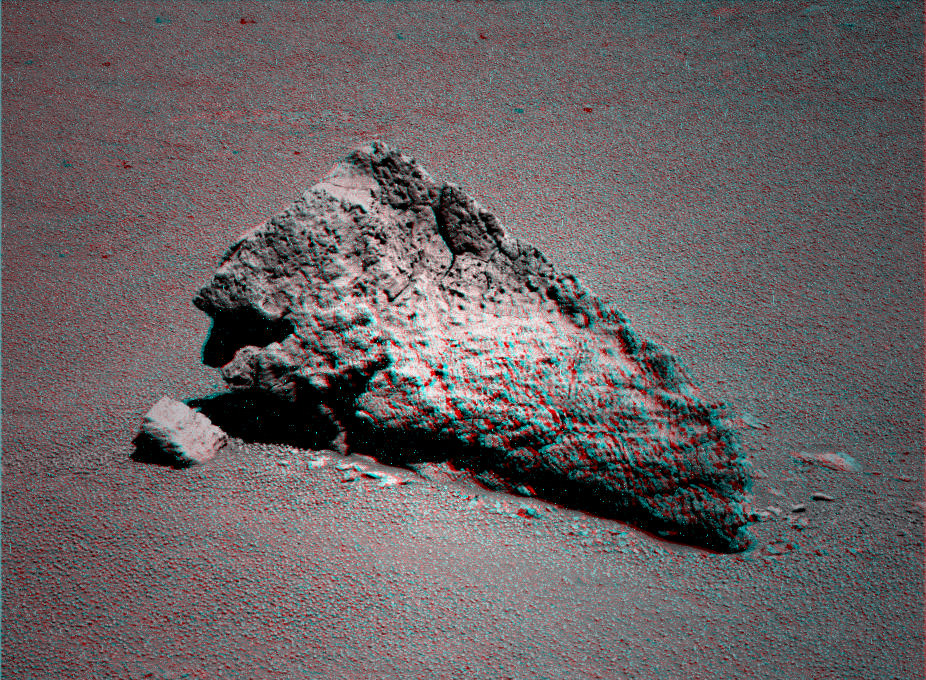
Opportiunity drove past this amazing looking ejecta rock at the outskirts of Santa Maria Crater while approaching the rim. Credit: NASA/JPL/Cornell/Stu AtkinsonRover wheel tracks on Mars
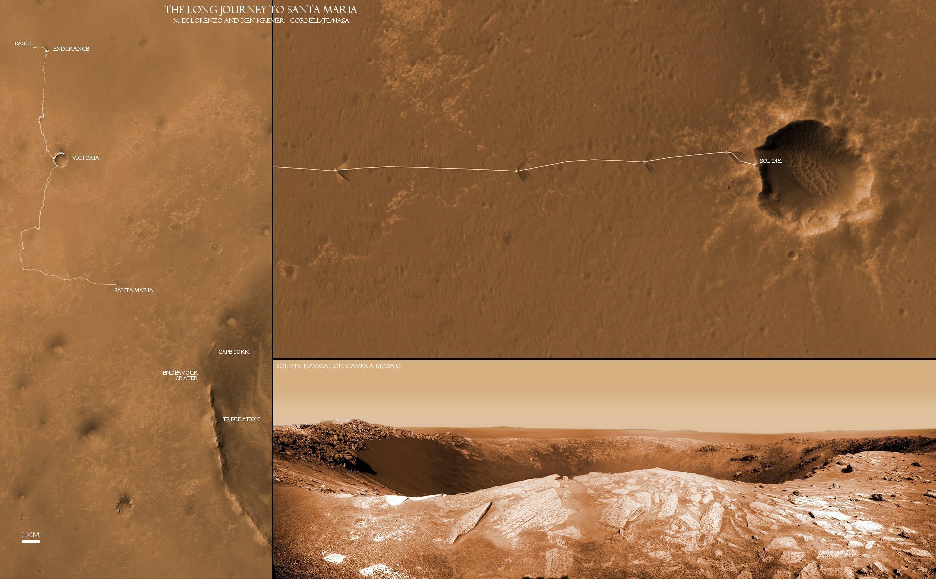
This mosaic of images from Sol 2451 (Not in 3 D) shows the tracks from Opportunity’s wheels on the approach to the steep crater rim on Sol 2450. Credit: NASA/JPL/Cornell, Marco Di Lorenzo, Ken KremerThe Long Journey to Santa Maria:
This collage of two maps and a 2 D close up panorama of Santa Maria crater (bottom right) shows the route traversed by the Opportunity Mars rover during her nearly 7 year long overland expedition across the Meridiani Planum region of Mars. Opportunity arrived at the rim of Santa Maria Crater on Dec. 16, 2010 on Sol 2451 and will drive around the edge in a counterclockwise direction to examine rocks which are indicative of the past flow of liquid water. The next destination is Endeavour Crater - some 22 km wide - to investigate water bearing minerals at Cape York and Cape Tribulation which she will reach sometime in 2011. Credit: NASA/JPL/Cornell, Marco Di Lorenzo, Ken Kremer
One final rocket launch in 2010 took place as Arianespace successfully launched the Hispasat 1E and KOREASAT 6 telecommunication satellites aboard an Ariane 5 ECA rocket from the Kourou spaceport in French Guiana. Liftoff was at 4:27 p.m. EST (21:27 GMT).
KOREASAT 6 is a commercial telecommunications satellite of the KT Corporation of the Republic of Korea and was built by Orbital Sciences Corporation. Hispasat 1E is a telecommunications satellite designed to expand Hispasat’s coverage in Europe, the Americas, and North Africa.
This is the sixth and final flight of the year for Arianespace’s heavy-lift rocket.
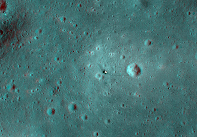
Apollo 11 landing site. Credit: NASA/GSFC/Arizona State University, 3-D by Nathanial Burton-Bradford.
[/caption]
With the Lunar Reconnaissance Orbiter Camera constantly snapping images of the lunar surface, we have been able to see most of the Apollo landing sites with better and better detail. Image editing wizard Nathanial Burton-Bradford has now “3-D-ified” all the landing sites except Apollo 16, and by viewing these images with 3-D glasses (the ones with red and cyan lenses) the lunar landers are easily visible and really stand out. Other features such as tracks and experiments left by the Apollo astronauts become more visible as well. See more images below, and click on the images for larger versions, or see Nathanial’s Flickr page for more!
The Apollo 12 landing site. Credit: NASA/GSFC/Arizona State University, 3-D by Nathanian Burton-BradfordApollo 14 landing site. Credit: NASA/GSFC/Arizona State University, 3-D by Nathanial Burton-Bradford.Apollo 15 landing site. Credit: NASA/GSFC/Arizona State University, 3-D by Nathanial Burton-Bradford.Apollo 17 landing site. Credit: NASA/GSFC/Arizona State University, 3-D by Nathanial Burton-Bradford
And for good measure, here’s one of the impact crater created by the Apollo 17 Saturn booster.
The crater made by the Apollo 17 booster. Credit: NASA/GSFC/Arizona State University, 3-D by Nathanial Burton-Bradford.
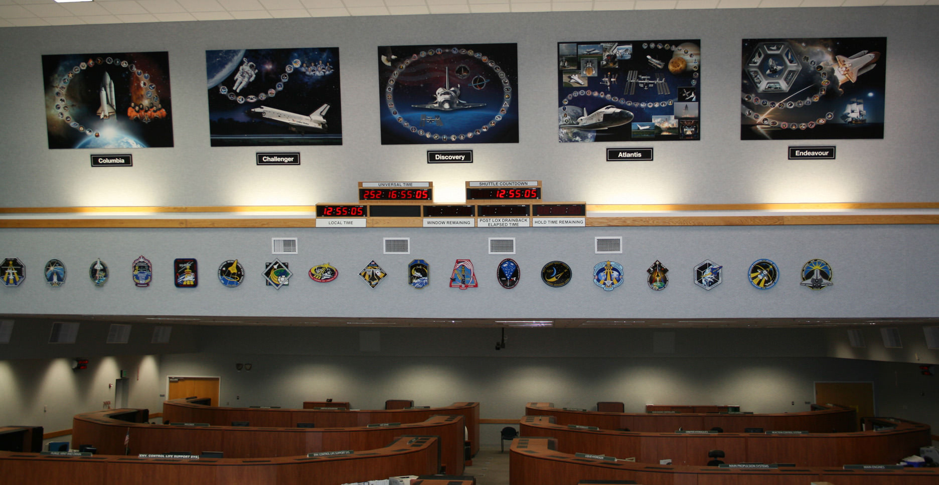
Memorial displays to all five Space Shuttle Orbiters were recently mounted inside the Space Shuttle Firing Room #4 - above the Shuttle countdown clock. These tribute displays highlight the significant achievements from the actual space voyages of the individual Orbiters launched from the Kennedy Space Center over three decades –starting with STS-1 in 1981. Credit: Ken Kremer
[/caption]
To mark the occasion of the Shuttle’s last Christmas, space shuttle worker Terry Sibile drafted a touching poem titled; “T’was the Shuttle’s Last Christmas”.
For your enjoyment Terry’s poem is reprinted below; as it appeared at Florida Today. The poem initially was circulated via email at the Kennedy Space Center (KSC) and other NASA sites across the US.
According to this article at Florida Today, Terry is a member of the engineering team dealing with cranes, platforms and doors which abound at the space center.
Only 2 or 3 flights remain before the shuttle is retired – at the peak of its performance – probably around mid-2011. NASA is still evaluating whether the budget will support flying the STS-135 mission to the International Space Station.
So it’s unlikely the shuttles will see another Christmas. Sibile’s poem thus marks another installment in the string of sad and bittersweet “lasts” for the shuttle program – “Our spirits were low … and soon we’d all go.”
The Space Shuttle Launch team at KSC recently created tribute displays to honor the achievements of all 5 Space Shuttle Orbiters and all the NASA and contractor workers involved. See photo above. Sibile’s poetry poignantly puts these displays into words.
‘Twas the Shuttle’s last Christmas by Terry Sibile
‘Twas the Shuttle’s last Christmas
and our spirits were low,
For the program was ending
and soon we’d all go.
We’d processed the Shuttles
with infinite care
And followed each mission
as if we were there.
We made every effort
to achieve all our goals;
We offered our talents,
our hearts and our souls.
Our work was much more
than a meager career;
‘Twas an honor and privilege
beyond all compare.
As this marvel of science
was applauded worldwide,
We looked on each Shuttle
with unfettered pride:
Columbia, Challenger,
Discovery, and then
Atlantis, Endeavour
all ferried brave men
And women to realms
past the confines of Earth,
Uncovering knowledge
of infinite worth.
We rejoiced with each mission’s
success, and we grieved
For the losses too painful
for us to conceive.
And over the years,
something wondrous took place:
We became kindred spirits,
united by Space.
And so, as we part,
I will bear a great loss.
And hope in the future
our paths again cross.
But until then, my friend,
this wish I confide:
Happy Christmas to all
— we had a great ride!
————————————-
Check out this 360 degree panoramic view from inside Firing Room 4 showing all five Shuttle tribute displays; recorded during my visit with Space Shuttle Launch Director Mike Leinbach. Leinbach led the effort to create the tribute displays. Courtesy of Nasatech.net
The Long Journey to Santa Maria: This collage of two maps and a new close up panorama of Santa Maria crater (bottom right) shows the route traversed by the Opportunity Mars rover during her nearly 7 year long overland expedition across the Meridiani Planum region of Mars. Opportunity arrived at the rim of Santa Maria Crater on Dec. 16, 2010 on Sol 2451. The rover has been on a crater tour since landing inside Eagle crater on Jan. 3, 2004. During her more than 26 km long journey she made numerous scientific discoveries along the way at Endurance and Victoria Craters. The rovers next destination is Endurance Crater - some 22 km wide - to investigate water bearing minerals at Cape York and Cape Tribulation which she will reach sometime in 2011. Credit: NASA/JPL/Cornell, Marco Di Lorenzo, Kenneth Kremer
[/caption]
The Opportunity rover is now sending back a plethora of awesome views of Santa Maria Crater since just arriving at the western edge of the crater on Dec. 15 (Sol 2450). This intermediate stop on the rovers 19 km long journey from Victoria Crater to giant Endeavour Crater looks to be well worth the trip and affords another fine feather in the science teams cap.
Santa Maria appears to be “relatively unweathered and fresh”, according to Ray Arvidson, of Washington University in St. Louis. Arvidson is the deputy principal investigator for the Spirit and Opportunity rovers. A bounty of boulders and rocks from the ejecta ring the rim. The crater is roughly 90 meters in diameter with an estimated depth between 9 to 14 meters. It is somewhat oval in shape, not perfectly circular.
Opportunity looks back to the long road to Santa Maria
After initially driving to a distance of about five meters from the rim on Dec. 16 (Sol 2451), Opportunity has now carefully crawled even nearer to the precipice of the craters steep cliffs. At each spot the rover snaps a series of panoramic images to document the site scientifically and esthetically and plan the next sols drive.
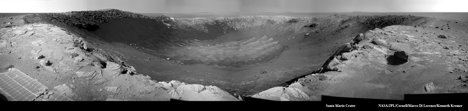
The team back on Earth – and millions of kilometers away – must tread with extreme caution as Opportunity creeps ever closer to the edge lest she fall off a cliff. Whereas the cameras revealed a dramatic gaping hole on Dec. 16, Opportunity is now positioned close enough to point her cameras directly at the steep walled cliffs and towards the sand dunes at the crater floor crater unveiling another stunningly gorgeous Martian vista.
Compare the panoramas from Sols 2451 and 2454 above and below as Opportunity pulled up to the rim in stages and began exploring the crater environment from different vantage points.
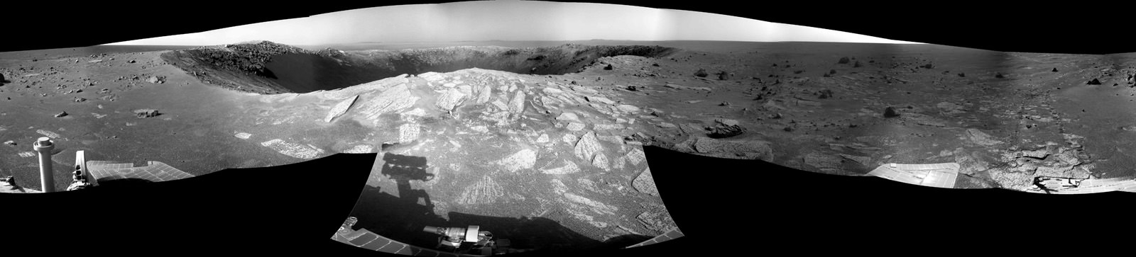
Panoramic view of Santa Maria Crater taken by Opportunity Mars rover about 5 meters from the rim on Dec 16, 2010 on Sol 2451. CRISM results suggest water bearing materials are located at the southeastern edge of the rim located roughly at the center of this image. Portions of distant Endeavour Crater are faintly visible as bumps on the horizon in the background. The northern and eastern rims are located from left to center. Cape Tribulation is to the right. Credit: NASA/JPL/Cornell, Kenneth Kremer, Marco Di LorenzoThe complete panoramic view of Santa Maria Crater taken by Opportunity Mars rover about 5 meters from the rim on Dec 16, 2010 on Sol 2451. Credit: NASA/JPL/Cornell, Jan van DrielPeering into Santa Maria Crater. Opportunity drove closer to within 5 meters of the rim and snapped this gorgeous panoramic vista unveiling the whole interior on Sols 2453 & 2354. Note the steep walls and sand dunes on the floor. Credit: NASA/JPL/Cornell, James CanvinPanoramic view revealing interior steep cliffs and sand dunes of Santa Maria Crater was taken within 5 meters of the rim on Sol 2454. Credit: NASA/JPL/Cornell, Marco Di Lorenzo, Kenneth Kremer
The rover handlers are highly adept at precisely maneuvering the 175 kg vehicle back and forth inside the danger zone at crater rims. After all Opportunity has been on a crater tour for her entire 7 year extended mission to the red planet and controllers at NASA’s Jet Propulsion Laboratory (JPL) have honed their driving techniques at countless locales both treacherous and dazzling, especially about the precipitous 50 meter cliff drops at Victoria Crater.
High priority activity on the west side of Santa Maria includes collecting the first pair in a series of long-baseline, high resolution stereo panoramas which will be used to create a digital elevation map in 3 D, according to Guy Webster, the Public Affairs Officer at NASA’s Jet Propulsion Laboratory (JPL) in Pasadena, Calif., which manages the Mars Rover mission for NASA.
The newly assembled crater maps – see the first mosaics herein – will be scrutinized and utilized for planning the best locations to visit during the upcoming multi-week science campaign. .
JPL engineers will move Opportunity in a counterclockwise direction around the rim from the Sol 2450 approach point.
“One last drive before the Christmas break will take us ~ 20m away to a lookout point, to set us up for another drive next week,” tweeted JPL Rover driver Scott Maxwell. “Last weekend’s drive around Santa Maria took us to this gorgeous new outlook. It’s grand here.”
“There are no plans to enter the crater.” Webster confirmed to me. There is no reason to take a risk when Opportunity is so close to those phyllosilicate clays at Endeavour which formed in water and have never before been directly analyzed on the Martian surface.
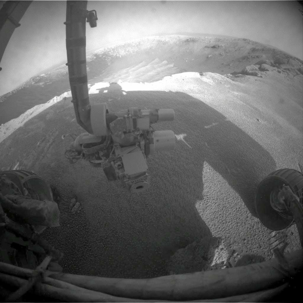
“Fisheye view of Santa Maria from the front hazcam camera with robotic arm instruments and two wheels. The RAT science drill is pointing to the left. . Credit: NASA/JPL/Cornell
The current plan calls for Opportunity to stay at Santa Maria through the upcoming Solar conjunction which starts in late January and ends in mid-February,” Webster stated.
The rover will remain stationary during that period and conduct a lengthy focused investigation of a specific spot using the instruments on the robotic arm – which include a rock drill, microscope and spectrometers.
“We will use the ‘no-new-commanding’ time of conjunction for a long-integration assessment of the composition of a selected target,” added Webster.
“The team plans to use Opportunity’s RAT- or Rock Abrasion Tool – on a target at Santa Maria,” says rover project manager John Callas of JPL. The RAT is a high tech device that uses a grinding wheel to cut into martian rocks and has performed far beyond expectation. The diamond embedded abrader teeth still have some life left, and the team wants to save some abrasion capability for the Endeavour rim targets.
Orbital Observations at Santa Maria Crater. Opportunity arrived at the western rim of Santa Maria Crater, some 90 meters wide, on Dec. 16, 2010. Researchers are using data collected by a powerful mineral mapping spectrometer (CRISM) aboard NASA’s Mars Reconnaissance Orbiter (MRO) to direct the route which Opportunity is traversing on Mars during the long term journey to Endeavour crater. Spectral observations recorded by CRISM indicates the presence of water-bearing sulfate minerals at the location shown by the red dot on the southeast rim crater whereas the crater floor at the blue dot does not. This image was taken by the High Resolution Imaging Science Experiment (HiRISE) camera also on MRO. Credit: NASA/JPL-Caltech/Univ. of Arizona
Orbital Sciences is one of many space companies that are vying to produce a 'space taxi.' Image Credit: Orbital Sciences Corporation
[/caption]
Once, the field had only had few entries, but now there are several companies vying to send American astronauts into orbit. With NASA’s Commercial Crew Development program, or CCDev 2, and the encouragement of commercial space firms to produce their own vehicles, the number of potential ‘space-taxis’ has swelled, with virtually every established and up-and-coming aerospace company either producing – or proposing one.
SpaceX has successfully demonstrated the capabilities of its Dragon spacecraft. Image Credit: SpaceX
One of the first firms to unveil a potential means of transportation to the International Space Station (ISS) was Space Exploration Technologies (SpaceX). SpaceX launched the first of its Dragon spacecraft on Dec. 8, and shortly thereafter became the first private company to safely recover a spacecraft after it returned from orbit.
Boeing was once of the first companies to unveil its proposal. Image Credit: Boeing
Not to be out done by the ‘new kid on the block’ Boeing unveiled its version of a space taxi this past September. Boeing’s Crew Space Transportation-100 (CST-100) spacecraft which it described could be used for missions to the space station or other ‘LEO platforms.’ One potentially exciting prospect about this endeavor is that any excess seating capacity will be available for purchase through Space Adventures.
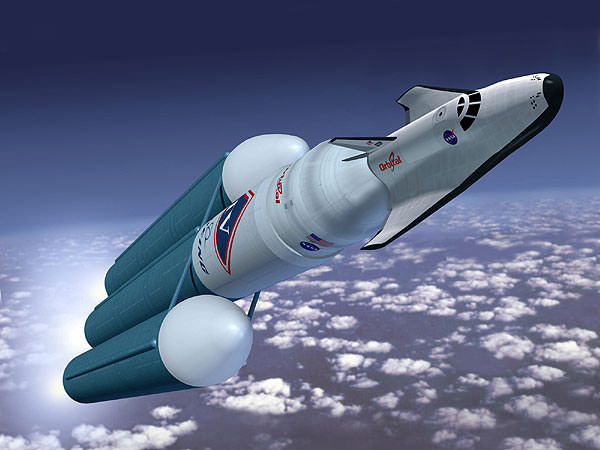
Orbital Sciences has proposed using a space plane to ferry astronauts to orbit: Image Credit: Orbital
A step away from what most of these companies are doing, Orbital Sciences has proposed producing a ‘mini-shuttle’ to ferry passengers to and from orbit. Most aerospace companies that have submitted designs and ideas have stepped away from the space plane concept as it is now viewed as too complicated and expensive. However, the U.S. Air Force recently successfully demonstrated the viability of its unmanned X-37B space plane. It was perhaps with this in mind that emboldened Orbital to go a step further and produce a man-rated mini space plane. Orbital images show their spacecraft proposal being lifted to orbit atop a Delta IV Heavy.
Just this month Virgin Galactic also announced its plans to produce a space plane (the company uses a space plane in its sub-orbital commercial efforts – this new space plane appears to be an extension of that).
Sierra Nevada also has proposed using a space plane as an orbital transport vehicle. Image Credit: Sierra Nevada Space
Lastly Sierra Nevada Corp also has thrown its name into the ring proposing a winged spacecraft. Their ‘Dream Chaser’ spacecraft is similar to Orbital’s proposal, a winged spacecraft that would be launched to orbit atop an expendable launch vehicle.
These companies are all vying for the $200 million that NASA has placed into a program to promote ease of access to orbit. While the Orion spacecraft, produced by Lockheed Martin, is part of a NASA program – these other organizations are hoping that by demonstrating the viability of their technology – that they can also secure a strong position in the emerging commercial space market.


