Opportunity rover Days Away from Mars Mountain Quest

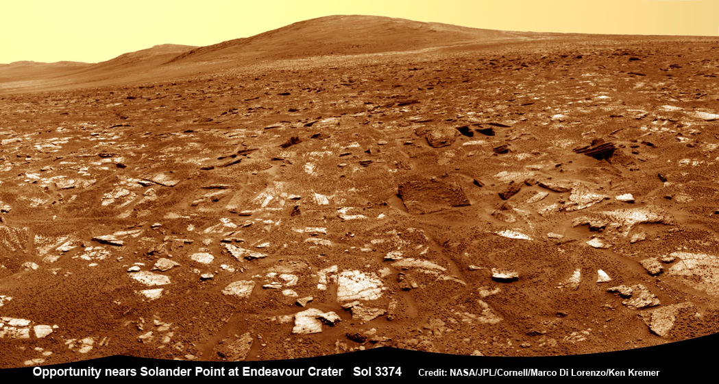
Opportunity rover’s view from very near the foothills of Solander Point looking along the rim and vast expanse of Endeavour Crater. Solander Point is the 1st Martian Mountain NASA’s Opportunity will climb and the rovers next destination. Solander Point may harbor clay minerals indicative of a past Martian habitable environment. This navcam mosaic was assembled from raw images taken on Sol 3374 (July 21, 2013). Credit: NASA/JPL/Cornell/Marco Di Lorenzo/Ken Kremer (kenkremer.com) See complete panoramic mosaic below

Opportunity rover’s view from very near the foothills of Solander Point looking along the rim and vast expanse of Endeavour Crater. This area exhibits gypsum signatures and numerous blocks of intriguing rock. Solander Point is the 1st Martian Mountain NASA’s Opportunity will climb and the rovers next destination. Solander Point may harbor clay minerals indicative of a past Martian habitable environment. This navcam mosaic was assembled from raw images taken on Sol 3374 (July 21, 2013). Credit: NASA/JPL/Cornell/Marco Di Lorenzo/Ken Kremer (kenkremer.com).
See complete panoramic mosaic below. Story updated with further details[/caption]

Exactly a decade after blasting off for the Red Planet and discovering a wide swath of water altered rocks and minerals in the ensuing years by exploring countless craters large and small, NASA’s intrepid Opportunity rover is just days away from arriving at her next big quest – a Martian mountain named Solander Point that may possess the key chemical ingredients necessary to sustain Martian life forms.

“We are parked 200 meters away from the bench at Solander Point,” Ray Arvidson told Universe Today exclusively. Arvidson is the mission’s deputy principal scientific investigator from Washington University in St. Louis, Mo. Furthermore, this area exhibits signatures related to water flow.

Solander Point also represents ‘something completely different’ – the first mountain the intrepid robot will ever climb.

“This will be Opportunity’s first mountain and the view from the ridge crest should be spectacular,” wrote Larry Crumpler, a science team member from the New Mexico Museum of Natural History & Science, in his latest field report about the 10 years ongoing Mars Exploration Rover (MER) mission.

Indeed the rover is now just a few short drives southward from making landfall on the northern tip of the point in her current trek across the relatively flat plains around the rim of Endeavour crater.

“We are now only about 180 meters from the new mountain, Solander Point.”
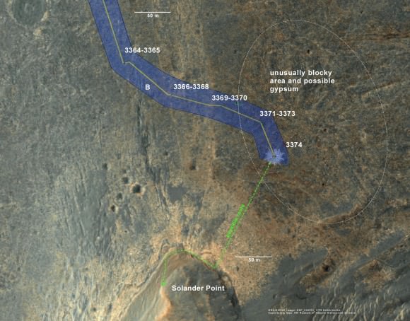
Opportunity rover location in the latest MRO/HiRISE color image. The green line shows more or less the route we hope to take to the base of Solander point. Since it is only a couple of hundred meters away, we could be there is a couple of drives. Maybe by the end of next week. The label say "3374" but this is also roughly the location through 3379.
Opportunity rover location in the latest MRO/HiRISE color image. The green line shows more or less the route we hope to take to the base of Solander point. Since it is only a couple of hundred meters away, the rover could be there is a couple of drives. Maybe by the end of next week. The label say “3374” but this is also roughly the location through 3379. NASA/JPL/Larry Crumpler

But before moving onward, Arvidson explained that the rover will briefly pause here “at dark terrain” for some exciting science due to water related spectral observations from the CRISM instrument captured by NASA’s Mars Reconnaissance Orbiter (MRO) circling overhead.

“CRISM data [from Mars orbit] shows a relatively deep 1.9 micrometer absorption feature due to H2O-bearing minerals,” said Arvidson.

This past spring, Opportunity made the historic discovery of clay minerals and a habitable environment on a low hill called Cape York at the rover’s prior stop along the rim of Endeavour crater.

Solander was selected as the robot’s next destination because it simultaneously offers a goldmine of science as well as north facing slopes – where Opportunity’s solar wings can more effectively soak up the sun’s rays to generate life giving electrical power during the next Martian winter.

But since Opportunity is currently generating plenty of power from her solar arrays and arriving with a bonus cushion of time before the looming onset of her 6th Martian winter, the team decided to take a small detour to the southeast and spend several sols (or Martian days) exploring an area of intriguing geology of outcrops, gypsum signatures and more on the bench surrounding the base of the mountain.

“We slowed down this week so that we could check out the rocks here where there is a strange hydration signature from orbital remote sensing,” says Crumpler.

“This is also an area that appears to have more large blocks in the HiRISE images [from Mars orbit], so we are checking out one of the blocks, “Black Shoulder”.

“We are hoping that the rocks on the ridge crest will be spectacular too,” notes Crumpler.

Opportunity rover’s view very near the foothills of Solander Point along the rim and vast expanse of Endeavour Crater.  Solander Point is the 1st Martian Mountain NASA’s Opportunity will climb and the rovers next destination. Solander Point may harbor clay minerals indicative of a past Martian habitable environment. This navcam panoramic mosaic was assembled from raw images taken on Sol 3374 (July 21, 2013).  Credit: NASA/JPL/Cornell/Marco Di Lorenzo/Ken Kremer (kenkremer.com)
Opportunity rover’s view very near the foothills of Solander Point along the rim and vast expanse of Endeavour Crater. This area exhibits gypsum signatures and numerous blocks of intriguing rock. Solander Point is the 1st Martian Mountain NASA’s Opportunity will climb and the rovers next destination. Solander Point may harbor clay minerals indicative of a past Martian habitable environment. This navcam panoramic mosaic was assembled from raw images taken on Sol 3374 (July 21, 2013). Credit: NASA/JPL/Cornell/Marco Di Lorenzo/Ken Kremer (kenkremer.com)

Opportunity is using the science instruments on her 3 foot ( 1 meter) long robotic arm to conduct brief in-situ investigations of “Black Shoulder” with the Microscopic Imager (MI) and the Alpha Particle X-ray Spectrometer (APXS).

And …. it’s ‘Mountains Galore’ from here on out for the remainder of Opportunity’s Magnificent Mission to Mars.

Why? Because Opportunity is nearing the foothills of a long chain of eroded segments of the crater wall of Endeavour crater which spans a humongous 14 miles (22 kilometers) wide.

Solander Point may harbor deposits of phyllosilicate clay minerals – which form in neutral pH water – in a thick layer of rock stacks indicative of a past Martian habitable zone.

The rover team is discussing the best way to approach and drive up Solander.

“One idea is to drive part way up Solander from the west side of the rim, turn left and then drive down the steeper north facing slopes with the stratographic sections,” Ray Arvidson explained to Universe Today.

“That way we don’t have to drive up the relatively steeper slopes.”

“The rover can drive up rocky surfaces inclined about 12 to 15 degrees.”

“We want to go through the stratographic sections on the north facing sections,” Arvidson told me.
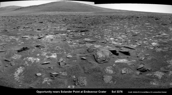
Opportunity rover moves closer to the foothills of Solander Point along the rim and vast expanse of Endeavour Crater.  The rover investigated one of the large rocks here with her microscopic imager and X-Ray spectrometer. Soon she will start climbing up Solander -  her 1st Martian Mountain ascent.  This navcam panoramic mosaic was assembled from raw images taken on Sol 3376 (July 23, 2013).  Credit: NASA/JPL/Cornell/Marco Di Lorenzo/Ken Kremer (kenkremer.com)
Opportunity rover moves closer to the foothills of Solander Point along the rim and vast expanse of Endeavour Crater. The rover investigated one of the large rocks near here with her microscopic imager and X-Ray spectrometer. Soon she will start climbing up Solander – her 1st Martian Mountain ascent. This navcam panoramic mosaic was assembled from raw images taken on Sol 3376 (July 23, 2013).
Credit: NASA/JPL/Cornell/Marco Di Lorenzo/Ken Kremer (kenkremer.com)

Today (July 28) is Sol 3380 for a mission that was only warrantied to last 90 Sols!

Opportunity’s total driving distance exceeds 23.6 miles (37.9 kilometers). She has snapped over 182,000 images.
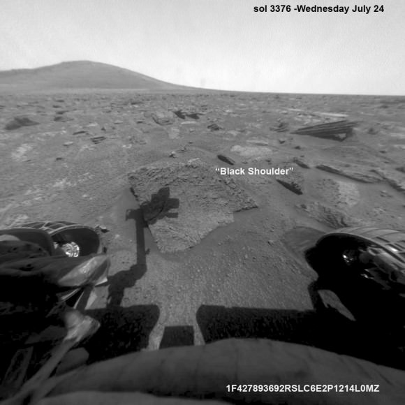
The "work volume". This view from the front hazcams shows the rock target that is being checked out before the final slog to the south. With luck, by the end of next week we will be plinking around the base of yonder mountain. "Plinking" is a geological term for wandering around with your hammer trying to get a handle on the local outcrops before plunging ahead with mapping and asking the rocks serious questions.  Credit: NASA/JPL/Larry Crumpler
The “work volume”. This view from the front hazcams shows the rock target that is being checked out before the final slog to the south. With luck, by the end of next week we will be plinking around the base of yonder mountain. “Plinking” is a geological term for wandering around with your hammer trying to get a handle on the local outcrops before plunging ahead with mapping and asking the rocks serious questions. Credit: NASA/JPL/Larry Crumpler

Meanwhile on the opposite side of Mars at Gale Crater, Opportunity’s younger sister rover Curiosity also discovered a habitable environment originating from a time when the Red Planet was far warmer and wetter billions of years ago.

And like Opportunity, Curiosity is also trekking towards a mountain rich in sedimentary layers hoping to unveil the mysteries of Mars past. But Curiosity likely won’t arrive at 3.4 mile (5.5 km) high Mount Sharp for another year.
Ken Kremer

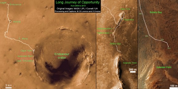
Traverse Map for NASA’s Opportunity rover from 2004 to 2013.  This map shows the entire path the rover has driven during more than 9 years and over 3374 Sols, or Martian days, since landing inside Eagle Crater on Jan 24, 2004 to current location near foothills of Solander Point at the western rim of Endeavour Crater.  Credit: NASA/JPL/Cornell/ASU/Marco Di Lorenzo/Ken Kremer
Traverse Map for NASA’s Opportunity rover from 2004 to 2013
This map shows the entire path the rover has driven during more than 9 years and over 3374 Sols, or Martian days, since landing inside Eagle Crater on Jan 24, 2004 to current location near foothills of Solander Point at the western rim of Endeavour Crater. Opportunity discovered clay minerals at Esperance – indicative of a habitable zone. Credit: NASA/JPL/Cornell/ASU/Marco Di Lorenzo/Ken Kremer

…………….
Learn more about Mars, Curiosity, Opportunity, LADEE, MAVEN, Antares and more at Ken’s upcoming lecture presentations

Aug 12: “RockSat-X Suborbital Launch, LADEE Lunar & Antares Rocket Launches from Virginia”; Rodeway Inn, Chincoteague, VA, 8 PM

Spacesuited Astronauts Climb Aboard Boeing CST-100 Commercial Crew Capsule for Key Tests

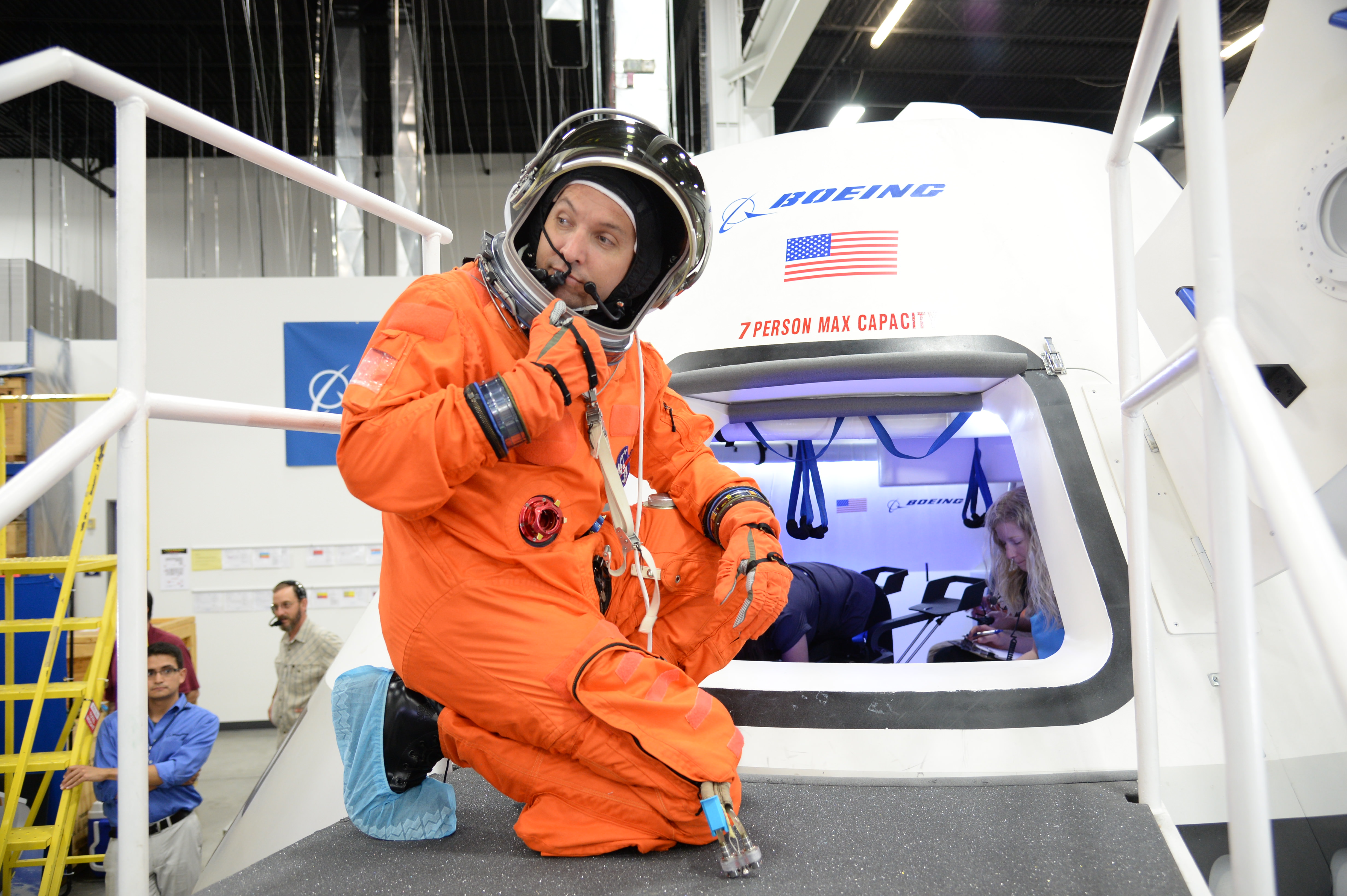
NASA astronaut Randy Bresnik prepares to enter the CST-100 spacecraft, which was built inside The Boeing Company's Houston Product Support Center. Credit: NASA/Robert Markowitz

A pair of NASA astronauts donned their spacesuits for key fit check evaluations inside a test version of the Boeing Company’s CST-100 commercial ‘space taxi’ which was unveiled this week for the world’s first glimpse of the cabin’s interior.

Boeing is among a trio of American aerospace firms, including SpaceX and Sierra Nevada Corp, seeking to restore America’s capability to fly humans to Earth orbit and the space station using seed money from NASA’s Commercial Crew Program (CCP).

Astronauts Serena Aunon and Randy Bresnik conducted a day long series of technical evaluations inside a fully outfitted, full scale mock up of the CST-100, while wearing NASA’s iconic orange launch-and-entry flight suits from the space shuttle era.

During the tests, Boeing technicians monitored the astronauts ergonomic ability to work in the seats and move around during hands on use of the capsules equipment, display consoles and storage compartments.

The purpose of the testing at Boeing’s Houston Product Support Center is to see what works well and what needs modifications before fixing the final capsule design for construction.

“It’s an upgrade,” said astronaut Serena Aunon at the evaluation. “It is an American vehicle, of course it is an upgrade.”

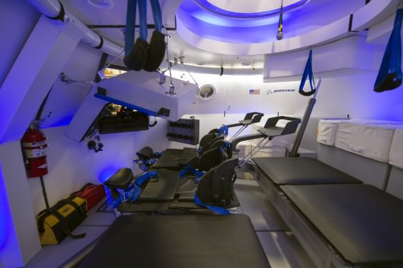
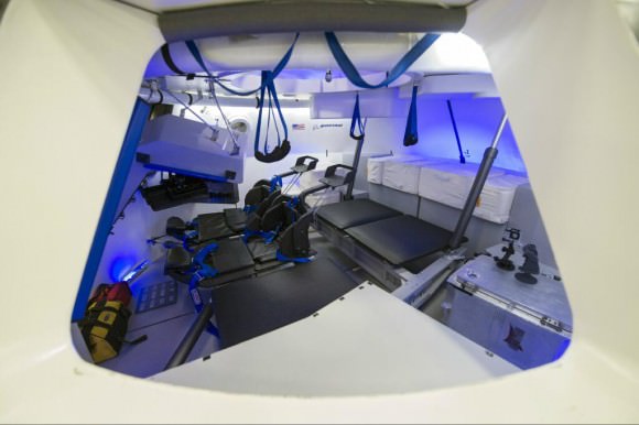
This is an interior view of The Boeing Company's CST-100 spacecraft, which features LED lighting and tablet technology.  Image Credit: NASA/Robert Markowitz
This is an interior view of The Boeing Company’s CST-100 spacecraft, which features LED lighting and tablet technology.
Image Credit: NASA/Robert Markowitz

Former NASA Astronaut Chris Ferguson, the commander of the final shuttle flight (STS-135) by Atlantis, is leading Boeing’s test effort as the director of Boeing’s Crew and Mission Operations.

“These are our customers. They’re the ones who will take our spacecraft into flight, and if we’re not building it the way they want it we’re doing something wrong,” said Ferguson.

“We’ll probably make one more go-around and make sure that everything is just the way they like it.”

The CST-100 is designed to carry a crew of up to 7 astronauts, or a mix of cargo and crew, on missions to low-Earth orbit (LEO) and the International Space Station (ISS) around the middle of this decade.

Although it resembles Boeing’s Apollo-era capsules from the outside, the interior employs state of the art modern technology including sky blue LED lighting and tablet technology.

Check out this video showing the astronauts and engineers during the CST-100 testing

Nevertheless Boeing’s design goal is to keep the flight technology as simple as possible.

“What you’re not going to find is 1,100 or 1,600 switches,” said Ferguson. “When these guys go up in this, they’re primary mission is not to fly this spacecraft, they’re primary mission is to go to the space station for six months. So we don’t want to burden them with an inordinate amount of training to fly this vehicle. We want it to be intuitive.”

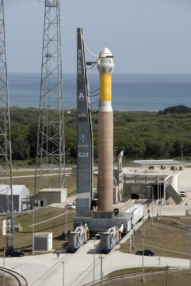
The CST-100 crew transporter will fly to orbit atop the venerable Atlas V rocket built by United Launch Alliance (ULA) from Launch Complex 41 on Cape Canaveral Air Force Station in Florida.

The CST-100 crew capsule awaits liftoff aboard an Atlas V launch vehicle at Cape Canaveral in this artist’s concept. Credit: Boeing

Boeing is aiming for an initial three day manned orbital test flight of the CST-100 during 2016, says John Mulholland, Boeing vice president and program manger for Commercial Programs.

The 1st docking mission to the ISS would follow in 2017 – depending on the very uncertain funding that Congress approves for NASA.

The Atlas V was also chosen to launch one of Boeing’s commercial crew competitors, namely the Dream Chaser mini shuttle built by Sierra Nevada Corp.

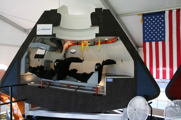
Boeing CST-100 capsule mock-up, interior view. Credit: Ken Kremer – kenkremer.com
Boeing CST-100 capsule early mock-up, interior view. Credit: Ken Kremer – kenkremer.com

NASA’s CCP program is fostering the development of the CST-100 as well as the SpaceX Dragon and Sierra Nevada Dream Chaser to replace America’s capability to launch humans to space that was lost following the retirement of NASA’s space shuttle orbiters two years ago in July 2011.

Since 2011, every American astronaut has been 100% dependent on the Russians and their Soyuz capsule to hitch a ride to the ISS.

“We pay one of our [ISS] partners, the Russians, $71 million a seat to fly,” says Ed Mango, CCP’s program manager. “What we want to do is give that to an American company to fly our crews into space.”

Simultaneously NASA and its industry partners are designing and building the Orion crew capsule and SLS heavy lift booster to send humans to the Moon and deep space destinations including Near Earth Asteroids and Mars.

Ken Kremer

Interior view of Boeing CST-100 commercial crew capsule. Credit: NASA

Curiosity Sets Record Pace for Longest Drive Yet on Mars

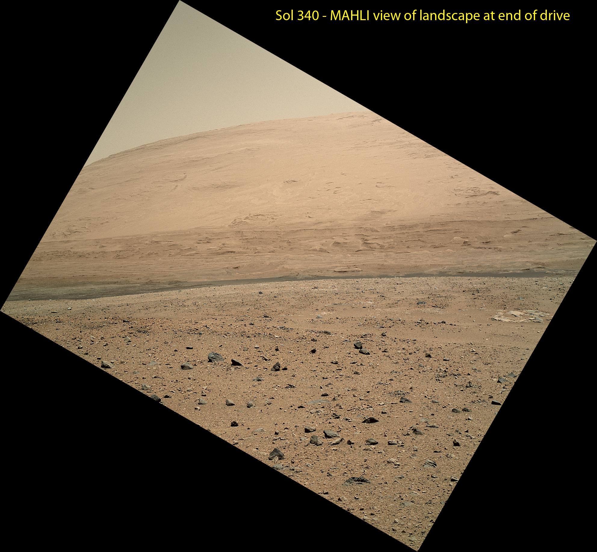
The scene taken on Sol 340 was taken shortly after Curiosity finished her longest yet. The 329.1-foot (100.3-meter) drive was twice as long as any previous sol's drive by Curiosity. The view is toward the south, including a portion of Mount Sharp and a band of dark dunes in front of the mountain. The Mars Hand Lens Imager (MAHLI) camera on NASA's Curiosity rover is carried at an angle when the rover's arm is stowed for driving. Still, the camera is able to record views of the terrain Curiosity is crossing in Gale Crater, and rotating the image 150 degrees provides this right-side-up scene. Credit: NASA/JPL-Caltech/MSSS

This scene was taken on Sol 340 shortly after Curiosity finished her longest drive yet
The 329.1-foot (100.3-meter) drive was twice as long as any previous sol’s drive by Curiosity. The view is toward the south, including a portion of Mount Sharp and a band of dark dunes in front of the mountain. The Mars Hand Lens Imager (MAHLI) camera on NASA’s Curiosity rover is carried at an angle when the rover’s arm is stowed for driving. Still, the camera is able to record views of the terrain Curiosity is crossing in Gale Crater, and rotating the image 150 degrees provides this right-side-up scene. Credit: NASA/JPL-Caltech/MSSS
See updated Traverse Map below[/caption]

NASA’s car-sized Curiosity rover is now blazing across the Red Planet’s surface and moving at a record setting pace towards a towering Martian mountain loaded with mineral caches that could potentially support a habitable environment.

On Sunday, July 21 (or Sol 340), Curiosity drove the length of a football field – 109.7 yards (100.3 meters) – a span that’s twice as far as she had ever driven before since the dramatic touch down on Mars nearly a year ago.

The previous record for a one-day drive was about half a football field – 54 yards (49 meters) – and achieved on Sol 50 (Sept. 26, 2012), roughly seven weeks after the pulse pounding landing inside Gale Crater on Aug. 6, 2012.

The 6 wheeled robot was able to move so far because on the prior drive she wound up atop a rise offering an uncommonly good view of the surrounding landscape and the road ahead across the crater floor towards Mount Sharp – the ultimate driving goal.

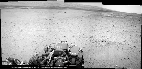
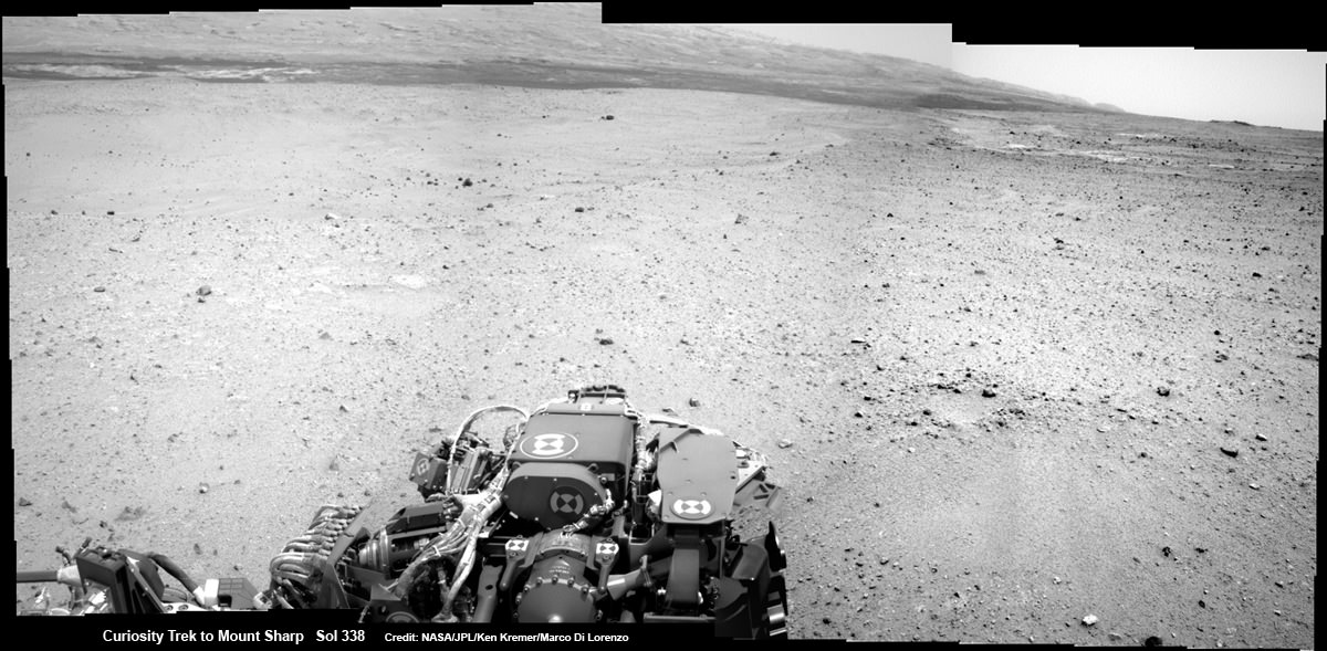
Curiosity On the Road to Mount Sharp and treacherous Sand Dunes - Sol 338 - July 19.  Curiosity captured this panoramic view of the path ahead to the base of Mount Sharp and potentially dangerous sand dunes after her most recent drive on July 19, 2013. She must safely cross over the dark dune field to climb and reach the lower sedimentary layers of Mount Sharp.   Credit: NASA/JPL-Caltech/Ken Kremer-(kenkremer.com)/Marco Di Lorenzo
Curiosity On the Road to Mount Sharp and treacherous Sand Dunes – Sol 338 – July 19
Curiosity captured this panoramic view of the path ahead to the base of Mount Sharp and potentially dangerous sand dunes after a recent drive on July 19, 2013. She must safely cross over the dark dune field to climb and reach the lower sedimentary layers of Mount Sharp.
Credit: NASA/JPL-Caltech/Ken Kremer-(kenkremer.com)/Marco Di Lorenzo

“What enabled us to drive so far on Sol 340 was starting at a high point and also having Mastcam images giving us the size of rocks so we could be sure they were not hazards,” said rover planner Paolo Bellutta of NASA’s Jet Propulsion Laboratory, Pasadena, Calif, in a NASA statement.

“We could see for quite a distance, but there was an area straight ahead that was not clearly visible, so we had to find a path around that area.”

Following another lengthy drive of 68.2 yards (62.4 meters) on Wednesday, July 23 (Sol 342), the mission’s total driving distance so far stands at 0.81 mile (1.23 kilometers).

Mount Sharp lies about 5 miles (8 kilometers) distant – as the Martian crow flies.

On July 4, Curiosity embarked on the epic trek to Mount Sharp after completing more than seven months of science investigations and historic interplanetary drilling and sample analysis at an area known as Glenelg and Yellowknife Bay. There she discovered a habitable environment with the chemical ingredients that could sustain Martian microbes- thereby already accomplishing the primary goal of NASA’s flagship mission to Mars.

A combination of increased experience by the engineers directing the mega rover as well as intermediate software upgrades also play key roles in speeding Curiosity towards 3.4 mile (5.5 km) high Mount Sharp.

A huge leap in roving across Mars is in the works soon using new driving software called autonomous navigation, or autonav, that will hasten the overland journey.

“We have put some new software – called autonav, or autonomous navigation – on the vehicle right after the conjunction period back in March 2013,” said Jim Erickson, Curiosity Project Manager, in exclusive interview with Universe Today. Erickson is from NASA’s Jet Propulsion Laboratory (JPL) in Pasadena, Calif.

“This will increase our ability to drive.”

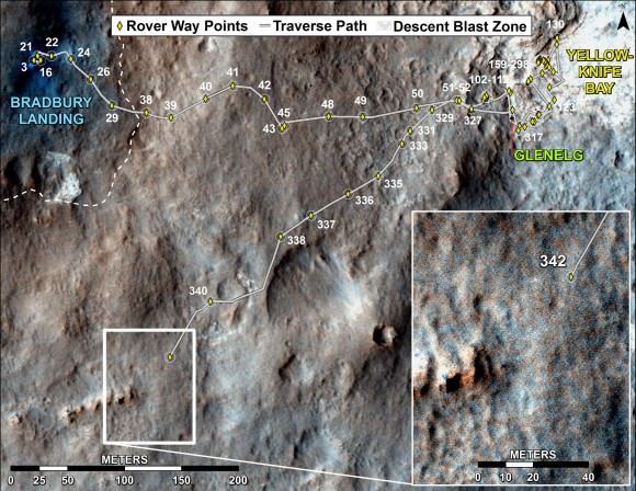
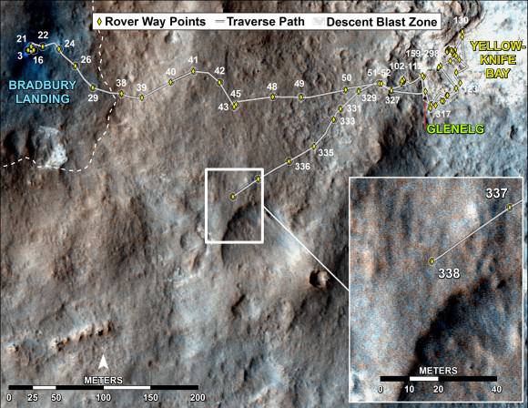
Curiosity's Traverse Map Through Sol 342. This map shows the route driven by NASA's Mars rover Curiosity through the 342 Martian day, or sol, of the rover's mission on Mars (July 21, 2013). Numbering of the dots along the line indicate the sol number of each drive. North is up. The scale bar is 200 meters (656 feet). From Sol 340 to Sol 342, Curiosity had driven a straight line distance of about 191.9 feet (58.49 meters).  The base image from the map is from the High Resolution Imaging Science Experiment Camera (HiRISE) in NASA's Mars Reconnaissance Orbiter.   Image Credit: NASA/JPL-Caltech/Univ. of Arizona
Curiosity’s Traverse Map Through Sol 342
This map shows the route driven by NASA’s Mars rover Curiosity through the 342 Martian day, or sol, of the rover’s mission on Mars (July 21, 2013). Numbering of the dots along the line indicate the sol number of each drive. North is up. The scale bar is 200 meters (656 feet). From Sol 340 to Sol 342, Curiosity had driven a straight line distance of about 191.9 feet (58.49 meters). The base image from the map is from the High Resolution Imaging Science Experiment Camera (HiRISE) in NASA’s Mars Reconnaissance Orbiter.
Image Credit: NASA/JPL-Caltech/Univ. of Arizona

Implementing the new driving software will make Curiosity smarter as well as more capable, productive and independent than ever before.

“With autonav the rover will have the ability to understand how far it’s driving, whether its slipping or not, and it improves safety,” Erickson told me.

The rover’s route is on a southwestward heading towards the ancient sedimentary layers at the foothills of the mountain in the middle of Gale Crater.

In addition to setting new driving records, the 1 ton rover is also driving more frequently and on repeated days too.

When everything synchs up, Curiosity can drive two or more days in row.

“We can drive two days in a row now if the timing is right. If we get the results of the day’s drive (n) in time before we have to plan the next day’s drive (n+1) – almost as if you’re on Mars time. Then that would work fine,” Erickson explained.

“Also, when we get the autonav capability we can plan two days in row. One day of directed driving and the second day can be ‘OK here’s your target from wherever you end up, try and go to this spot’.”

“This will increase the productivity!”

Erickson says the team is testing autonav now and should it be up and running within weeks, or sooner.

Read Part 1 & Part 2 of my interview with Jim Erickson for further details.

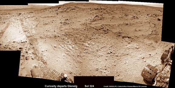
This photomosic shows NASA’s Curiosity departing at last for Mount Sharp- her main science destination. Note the wheel tracks on the Red Planet’s surface. The navcam camera images were taken on July 4, 2013 (Sol 324). Credit: NASA/JPL-Caltech/Ken Kremer (kenkremer.com)/Marco Di Lorenzo

Meanwhile Curiosity’s older sister rover Opportunity is making fast tracks towards her own mountain goal and should arrive at the base of Solander Point rather soon in August.

Solander Point is a segment of the eroded rim of huge Endeavour crater and may also possess key ingredients essential to support an environment favorable for possible Martian microbes.

And it’s worth noting that older sis Opportunity stills holds the 1 day Martian distance driving world record of 219.89 meters – established more than 8 years ago on Sol 410 (March 20, 2005)!!

Stay tuned for more on NASA’s sojourning pair of Martian robots.

Ken Kremer

The New Trailer for “Gravity” Depicts a Dizzying Disaster… in Orbit!

The newest trailer for "Gravity" shows the intensity of an accident in orbit. (©Warner Bros. Productions)

If you’ve ever been involved in one, you know that even a minor vehicle accident is a confusing and scary event. Trying to desperately regain control of your own movement as you’re suddenly subjected to forces beyond your control is stressful and terrifying… now imagine it happening at 17,500 mph and 230 miles up and you’ve got an idea of what the upcoming film “Gravity” is about.

Still can’t quite picture it? Check out the latest trailer below:

Directed and written by Alfonso Cuarón and co-written with his son Jonas, “Gravity” is the story of two astronauts (played by George Clooney and Sandra Bullock) whose shuttle is destroyed by a run-in with space junk during an EVA, stranding them both in orbit.

If that wasn’t bad enough, their oxygen is running out and they have lost communication with the ground. Cast adrift in orbit, they have to figure out how to survive and get back home.

It’s like “Open Water” in space. Without the sharks. (Let’s hope things turn out better for them!)

I enjoy sci-fi and I especially enjoy when they try to get the “sci” part right. How do things move in microgravity? (Hint: really fast.) What happens when stuff smashes together? What would happen to the human body in that situation? And, most importantly for any movie, how do the people involved handle the experience?

Above all, “Gravity” is still a movie so it has to take us on a two-hour, candy-munching, soda-slurping ride. Based on this latest trailer, I’m confident that they’ve done their homework on the mechanics of movement in orbit… now let’s see if Cuarón (Children of Men, Y Tu Mamá También, Harry Potter and the Prisoner of Azkaban)  has once again worked his storytelling magic to bring the characters to free-falling life.

A Warner Bros. Pictures production, “Gravity” will be released in IMAX 3D and 2D this October. See the official movie site here.

ADDED 7/25: Here’s a new clip, titled “I’ve Got You”:

Video ©2013 Warner Bros. Entertainment. All rights reserved.

Doctor Who? Astronauts Need To Figure Out Medical Procedures Before Leaving Earth

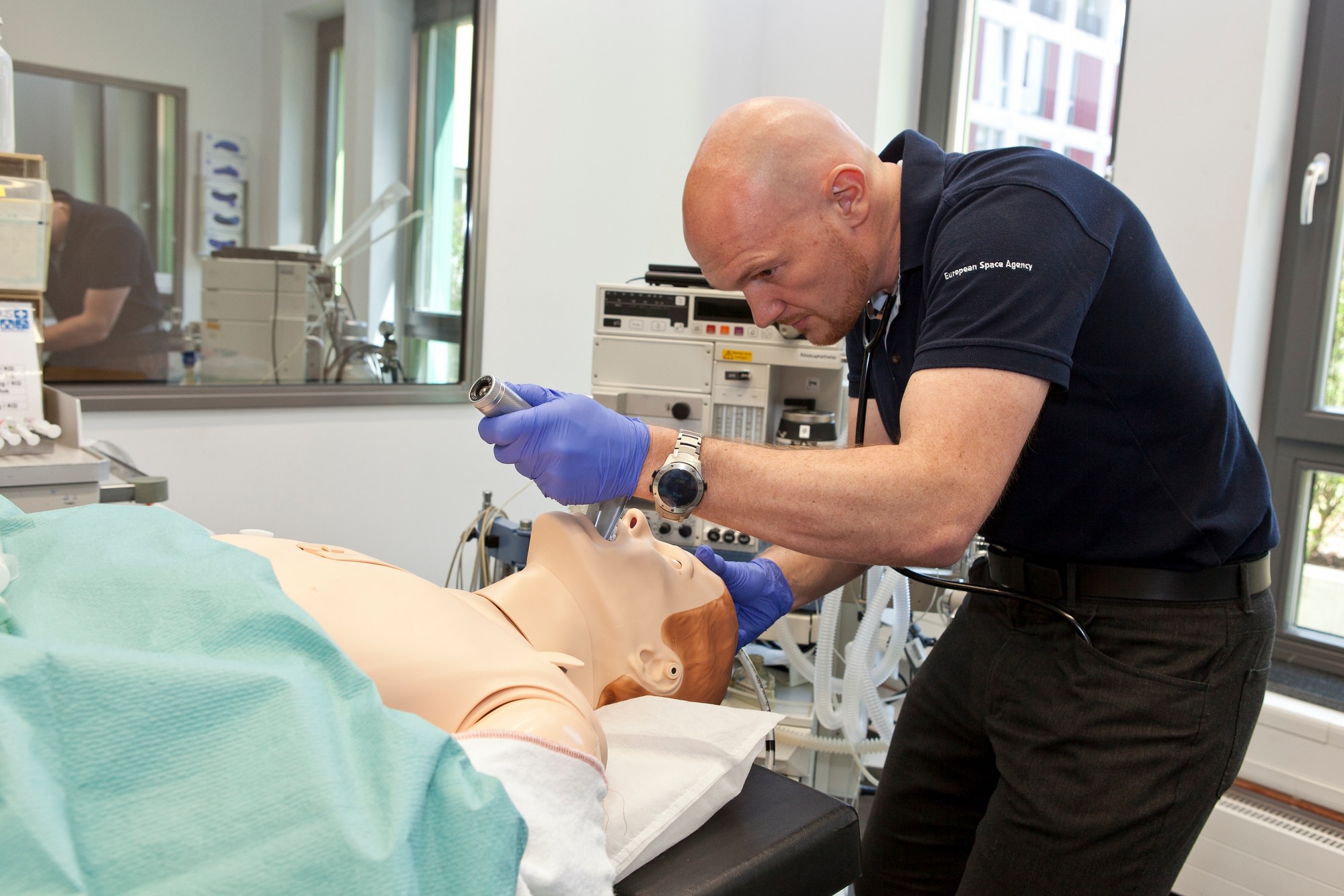
ESA astronaut Alexander Gerst practicing his medical skills on a mannequin. Credit: European Space Agency

Should an astronaut get sick on the International Space Station, that could be a bad scene given the nearest hospital requires a spaceship ride. That’s why every crew has at least two medical officers on board that can deal with some routine procedures, getting to items as complex as filling teeth, for example.

How to get that training done?

Here’s an example: above is Alexander Gerst, an astronaut with the European Space Agency, recently working with a mannequin at the Uniklinik Köln, a hospital in Cologne, Germany. The mannequin is at least as realistic as some baby dolls you can buy in stores: “it blinks, breathes and responds to injections”, ESA stated.

That’s in addition to three days Gerst spent in operating theatres, emergency and the intensive care unit at the hospital. He has about another year to do medical training before going to station for Expedition 40/41 in May 2014.

Chris Cassidy, an Expedition 36 flight engineer, tests his eyesight aboard the International Space Station. Credit: NASA

Mind you, help is also a phone call away to a ground control station, who has doctors on site. Also, there are a lot of medical doctors or similarly trained personnel that fly in space.

On board the International Space Station right now is a trained Navy SEAL, for example: Chris Cassidy. He would have been trained to treat injuries during combat. In May, he told Universe Today that he expects “muscle memory” would kick in during an emergency, whether medical or station-related:

“I think just the training that I got in the field, training in the early part of my Navy career, and during my time being an astronaut will all combine together,” he said.

“What I know from combat in the Navy, there’s a sort of calmness that comes over people who are well-trained and know what to do. Muscle memory kicks in, and it’s not until after the thing is over that you realize what you went through.”

While those who fly in space train for medical emergencies, they also serve as medical guinea pigs for ongoing experiments. Turns out microgravity simulates aging processes on Earth, so the research could have benefits on the ground in future decades. Here’s a couple of experiments happening right now on station:

  • Space Headaches: “Current, pre, in-flight and post-flight data via questionnaires to evaluate the prevalence and characteristics of crewmembers’ headaches in microgravity.”
  • Reaction Self Test:  “A portable 5-minute reaction time task that will allow the crewmembers to monitor the daily effects of fatigue on performance while on board the International Space Station.”

Looking at the medical aspect alone, it’s abundantly clear why astronauts spend years in training before flying to the station. Remember, though, this is on top of other science experiments they do there, not to mention repairs, maintenance and the occasional spacewalk or catching a supply spacecraft.

Sneak Peeks of the Earth and Saturn Panorama from Cassini on July 19

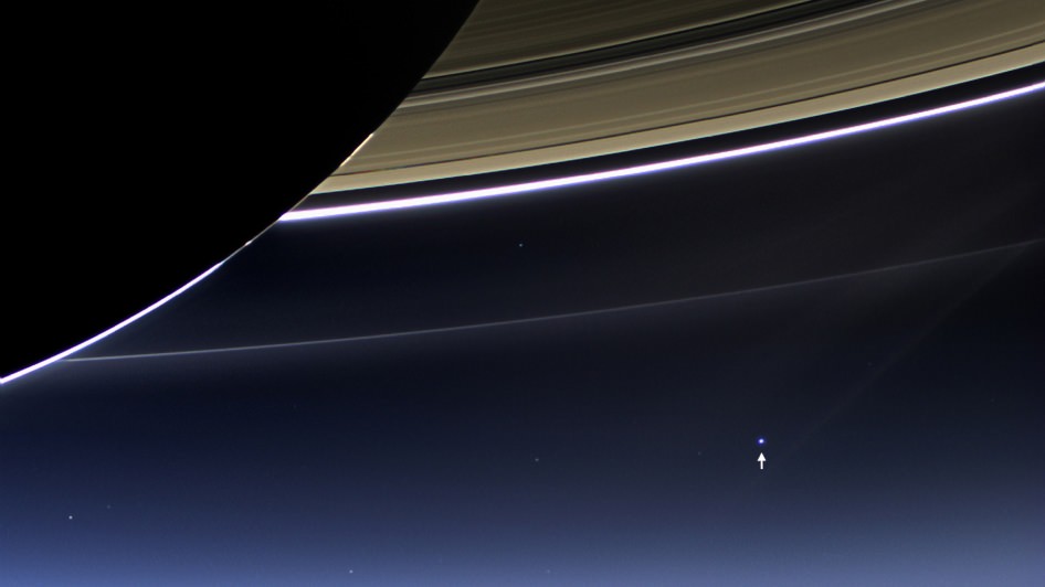
The Day the Earth Smiled: Sneak Preview. In this rare image taken on July 19, 2013, the wide-angle camera on NASA's Cassini spacecraft has captured Saturn's rings and our planet Earth and its moon in the same frame. Image Credit: NASA/JPL-Caltech/Space Science Institute

The Day the Earth Smiled: Sneak Preview
In this rare image taken on July 19, 2013, the wide-angle camera on NASA’s Cassini spacecraft has captured Saturn’s rings and our planet Earth and its moon in the same frame. Image Credit: NASA/JPL-Caltech/Space Science Institute
See below our wider context mosaic of the Earth, Saturn and its majestic rings[/caption]

Breathtaking raw images of the Earth and Saturn system snapped by NASA’s Cassini spacecraft on July 19 during the worldwide ‘Wave at Saturn’ campaign are streaming back across 1 billion miles of interplanetary space.

Science team members are now busily processing the images to create individual color composites and a panoramic view of the ‘pale blue dot’ and the entire Saturnian system.

NASA just released the first individual color composite focusing on Earth – see above. And its spectacular!

See below our preliminary mosaic showing the Earth in context with nearly half of Saturn and floating in between its incomparably majestic rings.

Partial context mosaic of the Earth and Saturn taken by NASA’s Cassini orbiter on July 19, 2013.   This mosaic was assembled from five wide angle camera raw images.  Credit: NASA/JPL-Caltech/Ken Kremer/Marco Di Lorenzo
Partial context mosaic of the Earth and Saturn taken by NASA’s Cassini orbiter on July 19, 2013. This mosaic was assembled from five wide angle camera raw images and offers a sneak peek of the complete panorama. Credit: NASA/JPL-Caltech/Ken Kremer/Marco Di Lorenzo

To capture all of Saturn and its wide swath of rings, Cassini’s wide angle camera snapped a mosaic of 33 footprints.

“At each footprint, images were taken in different spectral filters for a total of 323 images,” says Carolyn Porco, Cassini Imaging Team leader of the Space Science Institute in Boulder, Colo.

Cassini took the pictures of Earth between 2:27 and 2:42 p.m. PDT on Friday, July 19 from a distance of about 898 million miles (1.44 billion kilometers) away from the home to every human being that has ever lived.

The images show the Earth and the Moon as dots barely about a pixel wide but do reveal the ‘pale blue dot’ that is home to all of humanity and our whitish colored neighbor.

Coincidentally, the first humans (Neil Armstrong and Buzz Aldrin) set foot on the Moon 44 years ago nearly to the day of Cassini’s new images on July 20, 1969.

Distant views of the Earth from our robotic explorers, especially from the outer reaches of our Solar System, are few and far between, and are therefore events for space and astronomy enthusiasts and everyone else to savor.

“One of the most exciting Cassini events in 2013 will be the unusual opportunity on July 19 to image the whole Saturn system as it is backlit by the sun,” explained Linda Spilker, Cassini project scientist of NASA’s Jet Propulsion Laboratory, Pasadena, Calif.

“With Saturn covering the harsh light of the sun, we will be gathering unique ring science and also catching a glimpse of our very own home planet.”

Cassini previously took an absolutely fabulous mosaic of Saturn and Earth back in 2006 that stands as one of the landmark images of the space age.

Besides being picturesque, such mosaics also serve science. For example, the 2006 image “revealed that the dusty E ring, which is fed by the water-ice plume of the moon Enceladus, had unexpectedly large variations in brightness and color around its orbit,” says Spilker.

“We’ll want to see how that looks seven Earth years and a Saturnian season later, giving us clues to the forces at work in the Saturn system. We’ll do this analysis by collecting data from our visual and infrared mapping spectrometer, composite infrared mapping spectrometer and ultraviolet imaging spectrograph in addition to the imaging cameras.”

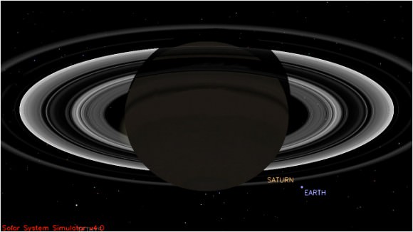
This simulated view from NASA's Cassini spacecraft shows the expected positions of Saturn and Earth on July 19, 2013, around the time Cassini will take Earth's picture. Cassini will be about 898 million miles (1.44 billion kilometers) away from Earth at the time. That distance is nearly 10 times the distance from the sun to Earth. Image credit: NASA/JPL-Caltech
This simulated view from NASA’s Cassini spacecraft shows the expected positions of Saturn and Earth on July 19, 2013, around the time Cassini will take Earth’s picture. Cassini will be about 898 million miles (1.44 billion kilometers) away from Earth at the time. That distance is nearly 10 times the distance from the sun to Earth. Image credit: NASA/JPL-Caltech

“July 19 marked the first time people on Earth had advance notice their planet’s portrait was being taken from interplanetary distances,” says NASA.

I waved fondly at Saturn and hope you had the chance to wave at Saturn from all across the globe. NASA reports that nearly 20,000 participated in organized events. Countless others waved too.

Cassini was launched in 1997 and achieved orbit at Saturn in 2004. The mission is scheduled to continue until 2017 when it will commit a suicide death dive into the gas giant.

“We can’t see individual continents or people in this portrait of Earth, but this pale blue dot is a succinct summary of who we were on July 19,” said Spilker in a NASA statement.

“Cassini’s picture reminds us how tiny our home planet is in the vastness of space, and also testifies to the ingenuity of the citizens of this tiny planet to send a robotic spacecraft so far away from home to study Saturn and take a look-back photo of Earth.”

Ken Kremer

JPL Waves at Saturn As NASA's Cassini spacecraft turned its imaging cameras to Earth, scientists, engineers and visitors at NASA's Jet Propulsion Laboratory, Pasadena, Calif., gathered to wave at our robotic photographer in the Saturn system on July 19, 2013. Credit: NASA/JPL-Caltech
JPL Waves at Saturn
As NASA’s Cassini spacecraft turned its imaging cameras to Earth, scientists, engineers and visitors at NASA’s Jet Propulsion Laboratory, Pasadena, Calif., gathered to wave at our robotic photographer in the Saturn system on July 19, 2013. Credit: NASA/JPL-Caltech

Expedition 37/38’s Tips For Surviving Long Voyages in Space

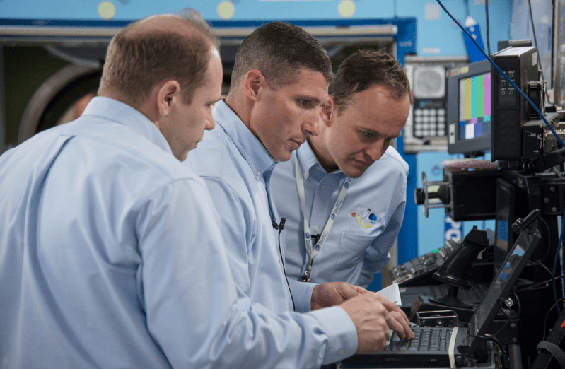
Russian cosmonaut Oleg Kotov (left), Expedition 37 flight engineer and Expedition 38 commander; along with NASA astronaut Michael Hopkins (center) and Russian cosmonaut Sergey Ryazanskiy, both Expedition 37/38 flight engineers. Credit: NASA

NASA wants to bring its astronauts outside of Earth. It recently recruited a new astronaut class for deep space voyages. It’s talking about picking up asteroids and possibly heading to the moon or Mars in the distant future. But there are a heck of a lot of steps to do before anyone can head into space for long periods of time.

The agency and Roscosmos are preparing for a one-year voyage to the International Space Station in 2015 that will add to the limited set of data on people being in space consecutively for a year, or longer. You can bet there will be reams of information collected on sleep habits, bone loss, muscle shrinkage, eye pressure and other health factors of concern.

How about the psychological side? The next space station crew to launch gave some hints about how their training prepares them to live cheek-by-jowl in a tiny space for six months.

The mission’s main goal:

The main goal is to put the station in a good condition, and also for the Russian segment, to [install] the new module, MLM (Multipurpose Laboratory Module.) We’re all targeted to this job. Me especially, being the commander of the station, I have the responsibility of the whole crew and their success and also for their psych [psychological] atmosphere. That’s really what I want to do. — Oleg Kotov, Expedition 37 flight engineer, Expedition 38 commander and preparing for his third spaceflight

Receiving advice from past crews:

Sometimes it’s the little things in terms of how to deal with, for example … the food and your clothes and supplies. Other times it’s trying to make sure you’re focusing on the critical items, and not necessarily getting caught up in all the little details [because] you’re going to be there for such a long amount of time.  — Michael Hopkins, Expedition 37/38 flight engineer and rookie astronaut

The Mars 500 long-duration mission vs. flying to the space station:

Mars 500 was really aimed at science. Most of the station [work] is mostly of the safety of the crew and the safety of the station, and then the [next priority is] science. But it also was a great experience to see, psychologically, the space station can be isolating, and how great the influence of this psychology is on the crew. So that was really the experience. Being commander there helps me a lot in my training for real flight.” — Sergey Ryzansky, commander of a 105-day segment as part of phase two of the Mars 500 program, Expedition 37/38 flight engineer and rookie cosmonaut

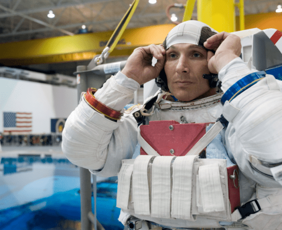
Michael Hopkins, Expedition 37/38 flight engineer, during spacewalk training. Credit: NASA

Communications with Mission Control:

Sometimes you ask a question or an item from the ground, and just realizing that you’re not always going to get that answer right away. Sometimes it takes some time for them to determine what the right answer is. — Hopkins

The challenge for other planets:

[I study] how to develop countermeasure means for flights on another planets. After 200 days, for example, flying in space, then we need human beings to work in a spacesuit on the surface of other planets, in different gravity. — Ryzansky

Curiosity Interview with Project Manager Jim Erickson-Part 2-Dealing with Dunes and Comet ISON on the Road to Mt. Sharp

Curiosity On the Road to Mount Sharp and treacherous Sand Dunes - Sol 338 - July 19. Curiosity captured this panoramic view of the path ahead to the base of Mount Sharp and potentially dangerous sand dunes after her most recent drive on July 19, 2013. She must safely cross over the dark dune field to climb and reach the lower sedimentary layers of Mount Sharp. Credit: NASA/JPL-Caltech/Ken Kremer-(kenkremer.com)/Marco Di Lorenzo

Curiosity On the Road to Mount Sharp and treacherous Sand Dunes – Sol 338 – July 19
Curiosity captured this panoramic view of the path ahead to the base of Mount Sharp and potentially dangerous sand dunes after her most recent drive on July 19, 2013. She must safely cross over the dark dune field to climb and reach the lower sedimentary layers of Mount Sharp. Stowed robotic arm on rover deck seen at center.
See JPL traverse map below pinpointing the view from this location
Credit: NASA/JPL-Caltech/Ken Kremer-(kenkremer.com)/Marco Di Lorenzo[/caption]

NASA’s state-of-the-art Curiosity Mars rover is stepping up the driving pace and rolling relentlessly across alien Martian terrain towards the towering mystery mountain known as Mount Sharp that’s holds the keys to the Red Planets past evolution and whether its an abode for Life.

To uncover the latest scoop on the robots otherworldly adventures, Universe Today conducted an exclusive interview with the Curiosity Project Manager Jim Erickson, of NASA’s Jet Propulsion Laboratory (JPL).

In Part 2 of my conversation with Jim Erickson we’ll discuss more about the rover’s traverse across alien territory that’s simultaneously a science gold mine and a potential death trap, as well as Comet ISON and nighttime observations and science planning.

Read Part 1 – here.

“When Comet ISON is in the sky I’m sure we’ll do some observations of it depending on when its visible,” Erickson told me.

Today, July 20, is Sol 339 of the rovers mission to Mars. And also the 44th anniversary of the 1st human Moonwalks in 1969.

And Curiosity just drove another 34 meters yesterday, Sol 338 (July 19) – for a total distance exceeding 1.1 kilometers.

Curiosity's Traverse Map Through Sol 338 This map shows the route driven by NASA's Mars rover Curiosity through Sol 338 of the rover's mission on Mars (July 19, 2013).  Numbering of the dots along the line indicate the sol number of each drive. North is up. The scale bar is 200 meters (656 feet). From Sol 337 to Sol 338, Curiosity had driven a straight line distance of about 122.90 feet (32.59 meters). The base image from the map is from the High Resolution Imaging Science Experiment Camera (HiRISE) in NASA's Mars Reconnaissance Orbiter.  Image Credit: NASA/JPL-Caltech/Univ. of Arizona
Curiosity’s Traverse Map Through Sol 338
This map shows the route driven by NASA’s Mars rover Curiosity through Sol 338 of the rover’s mission on Mars (July 19, 2013). Numbering of the dots along the line indicate the sol number of each drive. North is up. The scale bar is 200 meters (656 feet). From Sol 337 to Sol 338, Curiosity had driven a straight line distance of about 122.90 feet (32.59 meters). The base image from the map is from the High Resolution Imaging Science Experiment Camera (HiRISE) in NASA’s Mars Reconnaissance Orbiter. Image Credit: NASA/JPL-Caltech/Univ. of Arizona

As for Martian sand dunes, they dunes offer both exciting opportunities and lurking dangers to the rovers well being.

Indeed fields of Martian sand dunes are potential death traps and the six wheeled rover has no choice but to traverse across an extensive dune field as she closes in on the base of Mount Sharp

Recall that NASA’s now long lived Opportunity rover nearly perished rather early in her mission at the ‘Purgatory’ dune field on Meridiani Planum.

Spirit died after more than six highly productive years on the Red Planet when she was unable to escape a hidden sand trap she had accidentally fallen wheels deep into as the vehicle was merrily roving beside an eroded volcano at Gusev Crater on the approach to the mysterious Von Braun mound.

So, dunes are serious business

Here is Part 2 of my interview with Jim Erickson.

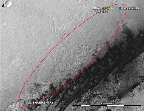
Ken Kremer: Which direction is Curiosity headed? Will she be following the southwest route shown in the ellipse on the JPL map – see traverse map below – or reinvestigate any other spots nearer the landing site first?

Jim Erickson: We have a good general idea. We will be on a general heading of southwest, not west which would have taken us back near the landing site [at Bradbury Landing].

Curiosity Route Map From 'Glenelg' to Mount Sharp. This map shows where NASA's Mars rover Curiosity landed in August 2012 at "Bradbury Landing"; the area where the rover worked from November 2012 through May 2013 at and near the "John Klein" target rock in the "Glenelg" area; and the mission's next major destination, the entry point to the base of Mount Sharp.  Credit: NASA/JPL-Caltech/Univ. of Arizona
Curiosity Route Map From ‘Glenelg’ to Mount Sharp
This map shows where NASA’s Mars rover Curiosity landed in August 2012 at “Bradbury Landing”; the area where the rover worked from November 2012 through May 2013 at and near the “John Klein” target rock in the “Glenelg” area; and the mission’s next major destination, the entry point to the base of Mount Sharp. Credit: NASA/JPL-Caltech/Univ. of Arizona

Ken: So the rover will not pass by the Hottah outcrop of concretions formed in water and investigated early in the mission?

Jim Erickson: No. The intent for the ellipse [shown on the map] is that we will be traveling in it to get to an area where the sand dunes look better for crossing [to the base of Mount Sharp]. When we get there we will know reality. And we will pick a safe spot to cross.

The dunes can be both an issue or in some cases easy sailing.

My experience on MER [Spirit & Opportunity] was that when you are going with the dunes, down a trough, they tend to be well packed and that was great driving.

But if you need to make a right turn, that can be a challenge for a couple of reasons. It is harder to see what is inside the next trough. And you have to drive to the top of the dune. So your driving is limited until you can see what’s inside the next dune.

Level ground is more straightforward. You know exactly what to look for if the terrain doesn’t change the next day. So you can do the same thing you did last night based on the new set of images.

If the terrain is changing then it gets more complicated.

Ken: Will you be straddling the dunes or driving alongside some safe distance away?

Jim Erickson: We have been going through various options of different planned routes. At some point we have to go with the dune directions.

So we’ll be traveling down some troughs later on. We will definitely have to pick our way through them.

Part of it is gaining experience in this new area of Mars with how the sand dunes and troughs themselves actually are.

So we’ll have to wait and see. We know we’ll have to deal with the dunes. Depending on how these dunes act we may have to do different things compared to MER.

Ken: What’s the health status of Curiosity?

Jim Erickson: We’re doing great. There are always active things we are looking at.

We had the anomaly before conjunction and have put in place a number of software mitigations and reconfigured the A side memory so that we can work around the hardware problem that happened. If we have another problem, both the A and B side memory can handle it gracefully, unlike the last time.

Ken: Describe the rover’s power situation? And the ability to do nighttime observations like the recent imagery of Phobos rising?

Read earlier Phobos story – here

Jim Erickson: Yes. We have plenty of power.

And certainly will be able to do nighttime observations.

Ken: What’s the plan for observations of Comet ISON?

Jim Erickson: When we get to the point when Comet ISON is in the sky I’m sure we’ll do some observations of it, depending on the time period when its visible.

Note: NASA’s Curiosity and Opportunity rovers will have a view of ISON in October with Oct. 1, 2013, being the comet’s closest approach to Mars.

NASA’s Directory of Planetary Science Jim Green told me previously that NASA is very interested in using its orbiting and surface assets at Mars to study Comet ISON. It’s a once in a lifetime opportunity.

Early October 2013 will be the prime viewing time for ISON from the vicinity of the Red Planet.

Let’s hope that NASA’s quartet of spacecraft and ESA’s lone orbiter capture some breathtaking imagery and science observations.

Ken: About the recent Phobos nighttime images, a Universe Today reader asked whether the other points of light beside Phobos were stars or hot pixels?

Jim Erickson: The specks are hot pixels [not stars], intensified by the long exposure times for the image.


Video Caption: ‘Phobos Rising’ – This movie clip shows Phobos, the larger of the two moons of Mars, passing overhead, as observed by Curiosity in a series of images centered straight overhead starting shortly after sunset on June 28, 2013. Phobos first appears near the lower center of the view and moves toward the top of the view. The apparent ring is an imaging artifact. The other bright spots are hot pixels – not stars. Credit: NASA/JPL-Caltech

Ken: How about the prospects for science along the way to the mountain?

Jim Erickson: We expect to do science along the way to Mount Sharp, for example in terms of atmospheric measurements.

We will stop at some preplanned sites. Exactly which ones is still being debated by the scientists.

And we’ll do the right thing – If we see something spectacular along the way. Just because we may not have identified it previously, that doesn’t mean we won’t stop and examine it.

Things are going very well, says Erickson.

Erickson has worked in key positions on many NASA planetary science missions dating back to Viking in the 1970’s. These include the Galileo mission to Jupiter, both MER rovers Spirit & Opportunity, as well as a stint with the Mars Reconnaissance Orbiter (MRO).

I’ll have more upcoming from Jim about Curiosity’s Martian drilling activities.

As of today (July 20) Curiosity has driven nine times since leaving the Glenelg/Yellowknife Bay area on July 4 (Sol 324), totaling nearly 300 meters.

Stay tuned for more from Mars.

Ken Kremer

This photomosic shows NASA’s Curiosity departing at last for Mount Sharp- her main science destination. Note the wheel tracks on the Red Planet’s surface. The navcam camera images were taken on July 4, 2013 (Sol 324). Credit: NASA/JPL-Caltech/Ken Kremer (kenkremer.com)/Marco Di Lorenzo
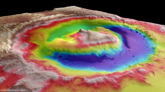
Mount Sharp inside Gale Crater - is the primary destination of NASA’s Curiosity rover mission to Mars.  Curiosity landed on the right side of the mountain as shown here, near the dune field colored dark blue.  Mount Sharp dominates Gale Crater. It is 3.4 mile (5.5 km) high.  Gale Crater is 154 km wide. This image was taken by the High Resolution Stereo Camera (HRSC) of ESA’s Mars Express orbiter.  Credit: ESA/DLR/FU Berlin (G. Neukum)
Mount Sharp inside Gale Crater – is the primary destination of NASA’s Curiosity rover mission to Mars. Curiosity landed on the right side of the mountain as shown here, near the dune field colored dark blue. Mount Sharp dominates Gale Crater. It is 3.4 mile (5.5 km) high. Gale Crater is 154 km wide. This image was taken by the High Resolution Stereo Camera (HRSC) of ESA’s Mars Express orbiter. Credit: ESA/DLR/FU Berlin (G. Neukum)

Apollo 11 F-1 Engine Finding Confirmed by Jeff Bezos on Eve of 1st Human Moonwalk

Saturn V Moon Rocket F-1 Engine Thrust Chamber recovered from the floor of the Atlantic Ocean. Credit: Jeff Bezos Expeditions

In a fitting testament to NASA’s momentous Apollo Moon Landing Program, NASA and billionaire Jeff Bezos confirmed today (July 19) the discovery of a powerful F-1 first stage engine component from the Saturn V moon rocket that launched three American astronauts on the historic journey of Apollo 11 to land the first two humans on the Moon on July 20, 1969.

“On the eve of the 44th moonwalk anniversary, the Bezos Expedition confirms an Apollo 11 Saturn V F1 engine find,” NASA officially announced on its websites just moments ago today, July 19.

Apollo 11 commander and NASA astronaut Neil Armstrong, was immortalized forever when he first set foot on the moon 44 years ago tomorrow (July 20, 1969), followed minutes later by the lunar module pilot, NASA astronaut Buzz Aldrin.

The Saturn V rockets first stage was powered by a cluster of five F-1 engines – a technological marvel and the most powerful single-nozzle, liquid-fueled rocket engine ever developed.

“44 years ago tomorrow Neil Armstrong stepped onto the moon, and now we have recovered a critical technological marvel that made it all possible,” says Bezos on his Expedition website today.

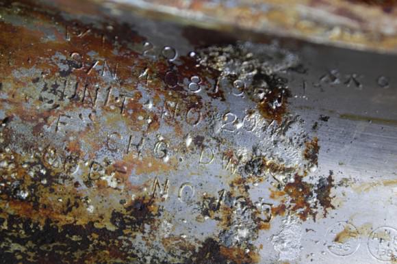
Apollo 11 Saturn V F-1 Engine Thrust Chamber recovered from the floor of the Atlantic Ocean- stenciled with Rocketdyne serial number “2044”. Credit: Jeff Bezos Expeditions

Bezos, founder and Chief Executive Officer of the aerospace company Blue Origin and Amazon.com, originally announced the discovery and recovery of significant components of two flown F-1 engines amongst a field of twisted wreckage from the floor of the Atlantic Ocean in March of this year, aboard the Seabed Worker at Port Canaveral, Florida, along with a treasure trove of other major Saturn V components hauled up from a depth of almost 3 miles.

“We brought back thrust chambers, gas generators, injectors, heat exchangers, turbines, fuel manifolds and dozens of other artifacts – all simply gorgeous and a striking testament to the Apollo program,” wrote Bezos in a update this morning, July 19.

But until today, the engines exact identification remained elusive because of decades of severe seabed corrosion and their fiery, destructive end upon plunging and smashing unimpeded onto the ocean’s surface.

Saturn V F-1 Engine Nozzle recovered from the floor of the Atlantic Ocean. Credit: Jeff Bezos Expeditions
Saturn V F-1 Engine nozzle recovered from the floor of the Atlantic Ocean. Credit: Jeff Bezos Expeditions

Conservators from the Kansas Cosmosphere and Space Center in Hutchinson, Kansas worked painstakingly since March to identify the F-1 engine parts.

“Today, I’m thrilled to share some exciting news. One of the conservators who was scanning the objects with a black light and a special lens filter has made a breakthrough discovery – “2044” – stenciled in black paint on the side of one of the massive thrust chambers, says Bezos.

“2044 is the Rocketdyne serial number that correlates to NASA number 6044, which is the serial number for F-1 Engine #5 from Apollo 11. The intrepid conservator kept digging for more evidence, and after removing more corrosion at the base of the same thrust chamber, he found it – “Unit No 2044” – stamped into the metal surface.”

Blacklight ocean view of Saturn V F-1 Engine recovered from the floor of the Atlantic Ocean.   Credit: Jeff Bezos Expeditions
Blacklight view of Apollo 11 Saturn V F-1 Engine recovered from the floor of the Atlantic Ocean with identifying “2044” serial number. Credit: Jeff Bezos Expeditions

Apollo 11 launched to the Moon on July 16, 1969 from Launch Complex 39-A at the Kennedy Space Center in Florida.

Armstrong and Aldrin landed on the Sea of Tranquility inside the Lunar Module. They took a single lunar excursion and spent 2 hours and 11 minutes as the first two men to walk on the moon. They stayed on the moon for a total of 21 hours and 36 minutes before blasting off for the journey back home to Earth.

Armstrong suddenly passed away nearly a year ago on August 25, 2012 at age 82 – read my stories, here and here.

Aldrin is still active and strenuously advocating for starting human expeditions to the Red Planet.

He outlined his exploration concepts in a newly published book titled – “Mission to Mars.”

neil_bg_800

The five F-1 engines used in the 138-foot-tall Saturn V first stage known as the S-IC generated 7.5 million pounds of liftoff thrust, or some 1.5 million pounds each. They stand 19 feet tall by 12 feet wide. Each one weighs over 18,000 pounds and was manufactured by Rocketdyne.

The F-1 had more power than all three space shuttle main engines combined. They burned a mixture of liquid oxygen and kerosene fuel for two-and-one-half-minutes, carrying the Saturn V to an altitude of some 36 miles.

Altogether, six Apollo Moon landing flights boosted by Saturn V’s sent a total of 12 humans on moon walking expeditions to Earth’s nearest neighbor during the 1960s and 1970s.

“This is a big milestone for the project and the whole team couldn’t be more excited to share it with you all,” Bezos wrote.

Bezos’ Blue Origin firm is also working to develop a commercial rocket and ‘space taxi’ to finally resume launching American astronauts back to low Earth orbit from American soil after a multi year gap.

More than four decades have passed since the last humans traversed the lunar surface in December 1972 during NASA’s Apollo 17 moon landing mission.

After all that time, the F-1 may yet live again.

NASA is now working on an upgraded F-1 to power a future variant of the new SLS heavy lift booster under development and intended to launch humans aboard the new Orion crew capsule back to the Moon and to deep space destinations including Asteroids and Mars.

NASA’s robotic exploration of the moon continues this year with the blastoff of the LADEE Lunar observatory on Sept. 6 from NASA’s Wallops Island facility in Virginia.

Ken Kremer

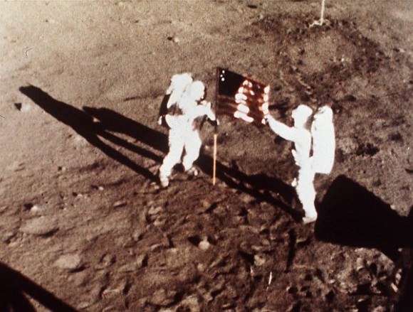
Neil Armstrong and Buzz Aldrin plant the US flag on the Lunar Surface during 1st human moonwalk in history - exactly 44 years ago on July 20, 1969 during Apollo 1l mission. Credit: NASA
Neil Armstrong and Buzz Aldrin plant the US flag on the Lunar Surface during 1st human moonwalk in history – exactly 44 years ago on July 20, 1969 during Apollo 1l mission. Credit: NASA

What’s Going To Happen With the NASA Budget?


As NASA’s fiscal 2014 budget proceeds through Congress, it’s still quite the ping-pong ball match to try to figure out where their budget numbers will fall. How do you think the budget will end up? Leave your thoughts in the comments.

Also, be sure to watch the latest markup on the NASA bill occurring today when the House Committee on Science, Space and Technology meets — the webcast is here. It starts at 11:15 a.m. EDT/3:15 p.m. GMT.

Obama administration initial request – $17.7 billion: Unveiled in early April, the $17.7 billion “tough choices” NASA budget was for $50 million less than requested in 2013; the actual FY 2013 budget was $16.6 billion due to cuts and sequestration. While reducing funding opportunities for planetary science, the FY 2014 budget provided funding for a NASA mission to capture an asteroid. The asteroid mission proposal, in later weeks, did not impress at least one subcommittee.

House Appropriations Committee – $16.6 billion. Last week, the committee’s proposal chopped off $1.1 billion from the initial request. The committee passed the Commerce, Justice, and Science appropriations bill with few changes this Wednesday. The $3.6 billion allotted for exploration is $202 million below FY 2013, which critics say will push back NASA’s ability to fund its commercial crew program to bring astronauts into space from American soil. The proposal, however, shields the Multi-Purpose Crew Vehicle and Space Launch System from schedule changes due to budgetary levels. NASA science programs in this budget were at $4.8 billion, $266 million below FY 2013. “This includes funding above the President’s request for planetary science to ensure the continuation of critical research and development programs,” the appropriations committee stated. This document contains a detailed breakdown of its budget for NASA.

Artist's conception of NASA's Space Launch System. Credit: NASA
It appears that NASA’s proposed Space Launch System is getting budgetary support from at least some House members. Credit: NASA

– U.S. Senate Appropriations Subcommittee on Commerce, Justice, Science, and Related Agencies – $18 billion: On Tuesday, the Senate subcommittee suggested an allocation to NASA of $18 billion. A press release says the budget level will give “better balance for all of NASA’s important missions, including $373 million more for science that helps us to better understand Earth and own solar system while peering at new worlds way beyond the stars. The Senate also provides $597 million more to let humans explore beyond low earth orbit while safely sending our astronauts to the space station on U.S. made vehicles.”

NASA’s reaction: David Weaver, NASA’s associate administrator for communications, said the agency is “deeply concerned” about the House funding levels. “While we appreciate the support of the Committee, we are deeply concerned that the bill under consideration would set our funding level significantly below the President’s request,” he wrote in a blog post, adding, “We are especially concerned the bill cuts funding for space technology – the “seed corn” that allows the nation to conduct ever more capable and affordable space missions – and the innovative and cost-effective commercial crew program, which will break our sole dependence on foreign partners to get to the Space Station. The bill will jeopardize the success of the commercial crew program and ensure that we continue to outsource jobs to Russia.”

Reaction of Commercial Spaceflight Federation: Much the same as NASA. “Less funding for the commercial

Dragon in orbit during the CRS-2 mission. Credit: NASA/CSA/Chris Hadfield
NASA fears there will not be enough money to fund commercial providers such as SpaceX  (Dragon cargo spacecraft pictured) who aim to bring astronauts to the space station themselves. Credit: NASA/CSA/Chris Hadfield

crew program simply equates to prolonged dependence on foreign launch providers,” stated federation president Michael Lopez-Alegria, who is a former NASA astronaut. “As a nation, we should be doing our utmost to regain the capability of putting astronauts in orbit on American vehicles as soon as possible.”

What’s next: The House Committee on Science, Space and Technology markup of the NASA bill takes place starting at 11:15 a.m. EDT/3:15 p.m. GMT (again, watch the webcast at this link.) We’ll keep you posted on what they say. The Planetary Society’s Casey Dreier, who said $16.6 billion is the smallest NASA budget in terms of purchasing power since 1986, points out that the House doesn’t have the final say: “The Senate still needs to weigh in, so this House budget is not the last word in the matter, but it’s deeply troubling. You can’t turn NASA on and off like a spigot. Cuts now will echo through the coming decades.”