An Apollo 17 astronaut digs in the lunar regolith to study the mechanical behavior of moon dust. Credit: NASA
That video above is perhaps the ultimate off-roading adventure: taking a rover out for a spin on the moon. Look past the cool factor for a minute, though, and observe the dust falling down around that astronaut.
The crew aboard Apollo 16 (as well as other Apollo missions) had a lot of problems with regolith. It got into everything. It was so abrasive that it wore away some equipment in days. It smelled funny and probably wasn’t all that good to breathe in, either. Many have said that when we return to the moon, dust must be dealt with for long-term survival.
Things could get worse at sunrise and sunset. One new study (not peer-reviewed yet) finds a “serious risk” that rovers “could be engulfed in dust.” That’s because lunar dust appears to have electrostatic properties that, somehow, is triggered by changes in sunlight. (NASA is already doing some serious investigation into this matter using its orbiting missions.)
What the researchers did, in conjunction with ONERA (The French Center of Aerospace Research) was conduct simulations for two types of lunar regions — the terminator (the day/night boundary) and an area experiencing full sunlight.
“Dust particles were introduced into the simulation over a period of time, when both the surface and the rover were in electrical equilibrium,” the Royal Astronomical Society stated.
“In both the test cases, dust particles travel upwards above the height of the rover, but results suggest that they move in different directions. On the day side, the particles are pushed outwards and on the terminator the dust travels upwards and inwards above the rover, regrouping in the vacuum above it. The terminator simulation began with a region void of dust which was later filled by lunar dust particles.”
The bottom line? A lunar rover could accumulate a significant amount of dust on the moon, especially if it’s sitting at or near the terminator. This could be addressed by using dome-shaped rovers that would see the dust fall off, added lead author Farideh Honary, a physicist at the University of Lancaster, in a statement.
The work was presented at the RAS National Astronomy Meeting today (July 3). A paper has been submitted to the Journal for Geophysical Research, so more details should be forthcoming if and when it is published.
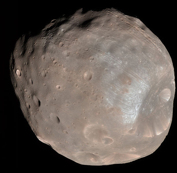
Mars moon Phobos rising in the night time Martian sky shortly after sunset in this image from a movie taken by NASA's Mars rover Curiosity on Sol 317, June 28, 2013. The apparent ring is an imaging artifact The Credit: NASA/JPL-Caltech See the complete ‘Phobos Rising’ movie below
Mars moon Phobos (above, center) rising in the night time Martian sky shortly after sunset in this still image from a movie taken by NASA’s Mars rover Curiosity on Sol 317, June 28, 2013. The apparent ring is an imaging artifact. Credit: NASA/JPL-Caltech See the complete ‘Phobos Rising’ movie below [/caption]
Every once in a while when the time is just right and no one is looking, Curiosity’s Earthly handlers allow her some night time Martian delights.
In this case a pair of rising and setting celestial events bookend another magnificent week in humankinds exploration of the Red Planet – courtesy of NASA.
This past week NASA’s Curiosity rover captured esthetically stunning imagery of Phobos rising and Our Sun setting on Mars.
Phobos is the larger of Mars pair of tiny moons. The other being Diemos.
On June 28, (Sol 317) Curiosity aimed her navigation camera straight overhead to captured a breathtaking series of 86 images as Phobos was ascending in the alien evening sky shortly after sunset.
NASA combined these raw images taken over about 27 minutes into a short movie clip, sped up from real time.
Video Caption: ‘Phobos Rising’ – This movie clip shows Phobos, the larger of the two moons of Mars, passing overhead, as observed by NASA’s Mars rover Curiosity in a series of images centered straight overhead starting shortly after sunset. Phobos first appears near the lower center of the view and moves toward the top of the view. The images were taken on June 28, 2013. The apparent ring is an imaging artifact. Credit: NASA/JPL-Caltech
The pockmarked and potato shaped moon measures about 26.8 × 22.4 × 18.4 kilometers.
Phobos orbits barely some 6,000 km (3,700 mi) above the Martian surface. One day far in the future, it will crash and burn.
On June 22, Curiosity snapped an evocative series of Martian sunset photos as Sol set behind the eroded rim of Gale Crater – see below.
In the 2030’s, Humans may visit Phobos first before setting foot on the much more technically challenging Red Planet.
Sunset at Gale Crater
Martian sunset vista at Gale crater rim snapped by Curiosity on Sol 312, June 22, 2013. Colorized navcam image. Credit: NASA/JPL-Caltech/Ken Kremer/Marco Di LorenzoPhobos from NASA’s Mars Reconnaissance Orbiter on March 23, 2008. Credit: NASA
At 2:38 UTC Tuesday morning (local time) a Russian Proton-M heavy lift rocket carrying three GLONASS navigation/positioning satellites exploded shortly after lifting off from the pad at Baikonur Cosmodrome. The event was captured on a live Russian news feed, seen above.
No word yet on whether there were any injuries or not according to NASASpaceflight.com, no casualties have been reported but the Proton rocket debris may have landed near another pad used by ILS (International Launch Services) — a U.S./Russian joint venture for commercial launches.
According to Anatoly Zak at RussianSpaceWeb.com, “since the emergency cutoff of the first stage engines is blocked during the first 42 seconds of the flight to ensure that the rocket clears the launch complex, the vehicle continued flying with its propulsion system firing practically until the impact on the ground.”
Reminder: space travel is (still) hard.
Update: Watch another view of the failed launch below:
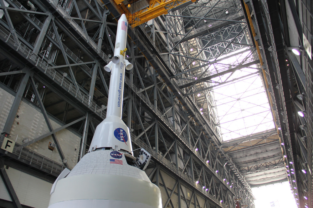
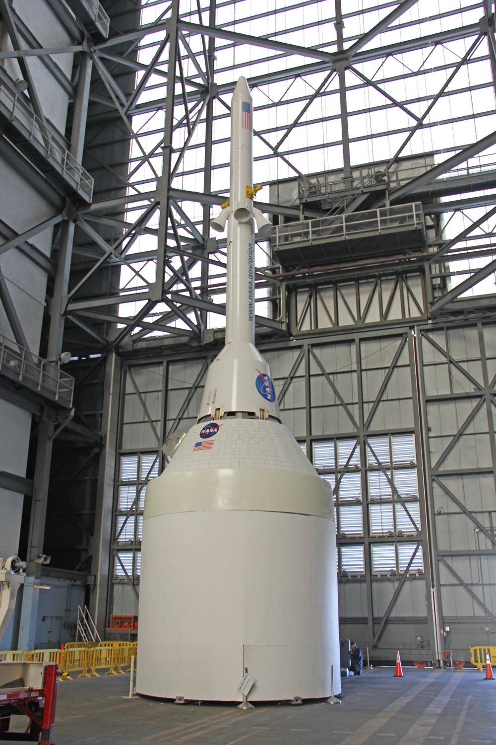
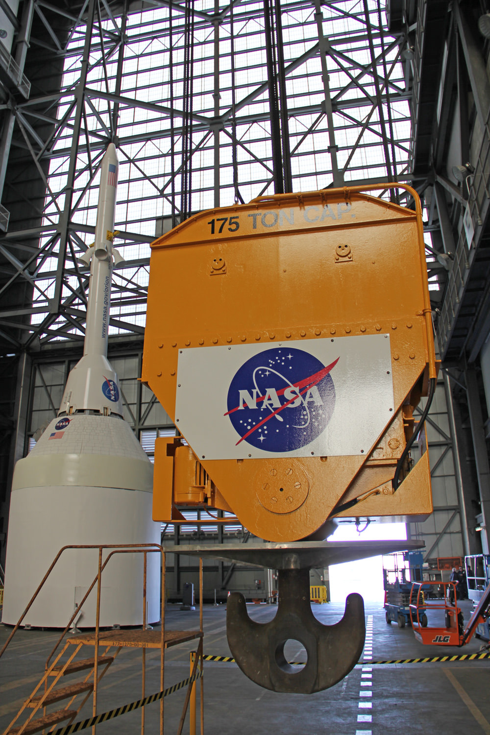
Technicians work on mockups of the Orion crew capsule, Service Module and 6 ton Launch Abort System (LAS) to simulate critical assembly techniques inside the Vehicle Assembly Building (VAB) at NASA’s Kennedy Space Center (KSC) in Florida for the EFT-1 mission due to liftoff in September 2014. Credit: Ken Kremer/kenkremer.com
KENNEDY SPACE CENTER, FL – NASA is picking up the pace of assembly operations for the Orion capsule, America’s next crew vehicle destined to carry US astronauts to Asteroids, the Moon, Mars and Beyond.
Just over a year from now in September 2014, NASA will launch Orion on its first test flight, an unpiloted mission dubbed EFT-1.
At NASA’s Kennedy Space Center in Florida, expert work crews are already hard at work building a myriad of Orion’s key components, insuring the spacecraft takes shape for an on time liftoff.
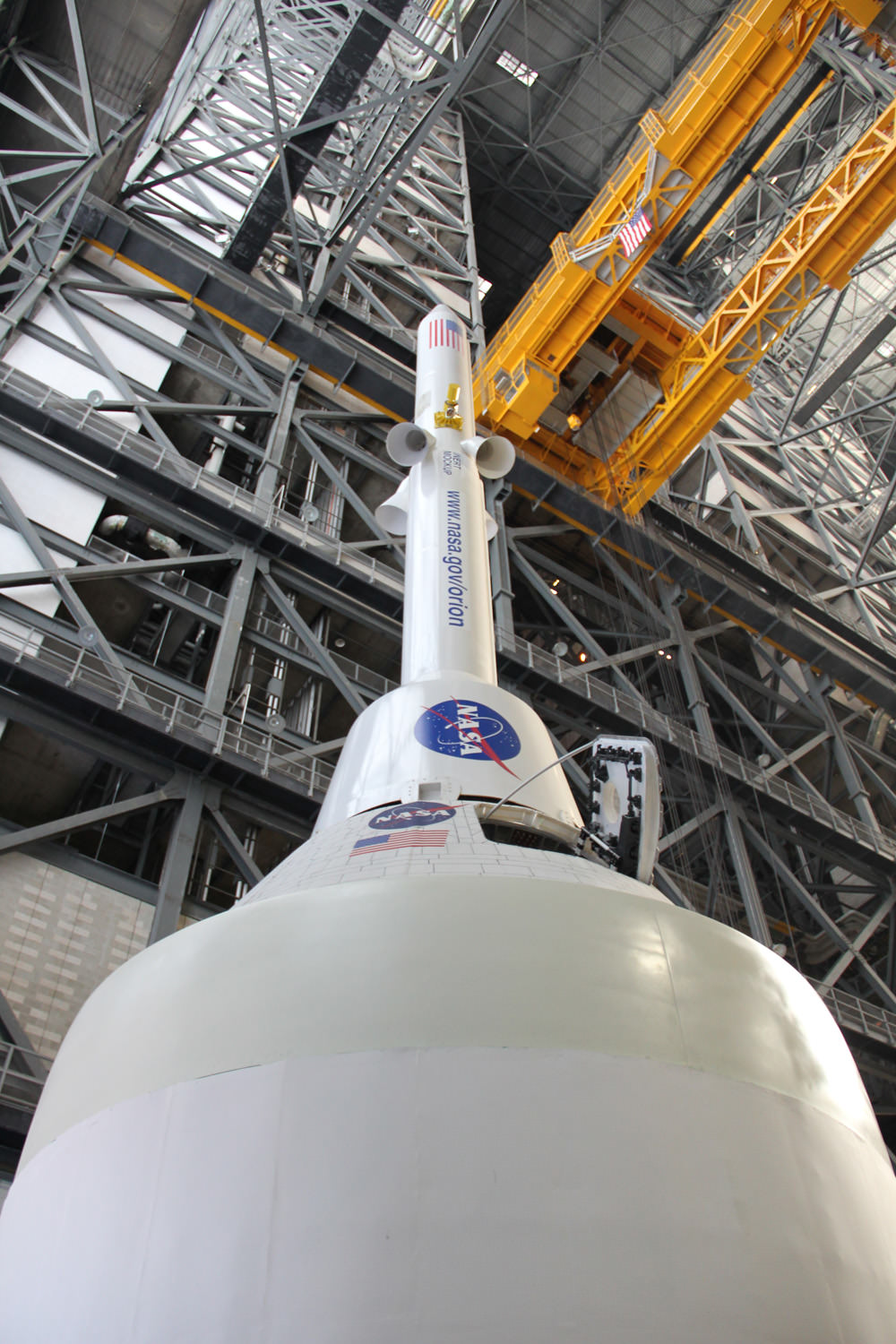
Orion crew capsule, Service Module and 6 ton Launch Abort System (LAS) stack inside the transfer aisle of the Vehicle Assembly Building (VAB) at the Kennedy Space Center (KSC) in Florida. Powerful quartet of LAS abort motors will fire in case of launch emergency to save astronauts lives. Credit: Ken Kremer/kenkremer.comUniverse Today is reporting on NASA’s progress and I took an exclusive behind the scenes tour inside KSC facilities to check on Orion’s progress.
In 2014 Orion will blast off to Earth orbit atop a mammoth Delta IV Heavy booster, the most powerful booster in America’s rocket fleet following the retirement of NASA’s Space Shuttle orbiters in 2011.
On later flights Orion will blast off on the gargantuan Space Launch System (SLS), the world’s most powerful rocket which is simultaneously under development by NASA.
At the very top of the Orion launch stack sits the Launch Abort System (LAS) – a critically important component to ensure crew safety, bolted above the crew module.
In case of an emergency situation, the LAS is designed to ignite within milliseconds to rapidly propel the astronauts inside the crew module away from the rocket and save the astronauts lives.
The LAS is one of the five primary components of the flight test vehicle for the EFT-1 mission.
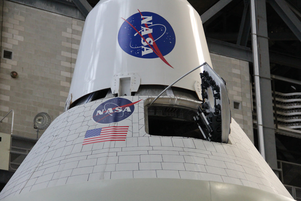
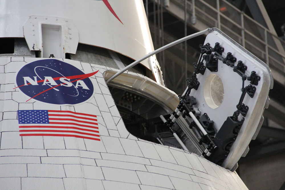
Astronaut hatch swung open on Orion capsule mock up joined to base of Launch Abort System (LAS) emergency escape tower. Credit: Ken Kremer/kenkremer.com
Prior to any launch from the Kennedy Space Center, all the rocket components are painstakingly attached piece by piece.
Final assembly for EFT-1 takes place inside the iconic Vehicle Assembly Building (VAB).
To get a head start on assembly with the launch date relentlessly approaching, technicians have been practicing lifting and stacking techniques for several months inside the VAB transfer aisle using the 6 ton LAS pathfinder replica and mock ups of the Orion crew and service modules.
This 175 ton hook and crane system used to maneuver the Orion crew capsule, Service Module and Launch Abort System (LAS) components inside the Vehicle Assembly Building the Kennedy Space Center (KSC) in Florida. Credit: Ken Kremer/kenkremer.com
Conducting the practice sessions now with high fidelity replicas serves multiple purposes, including anticipating and solving problems now before the real equipment arrives, as well as to keep the teams proficient between the years long launch gap between the finale of the Space Shuttle program and the start up of the Orion/SLS deep space exploration program.
Delicate maneuvers like lifting, rolling, rotating, stacking, gimballing and more of heavy components requiring precision placements is very demanding and takes extensive practice to master.
There is no margin for error. Human lives hang in the balance.
Technicians at work practicing de-stacking operations with full size mockups of the Orion capsule and Launch Abort System components inside the Vehicle Assembly Building at the Kennedy Space Center in Florida. Credit: NASA/Jim Grossmann
The same dedicated crews that assembled NASA’s Space Shuttles inside the VAB for 3 decades are assembling Orion. And they are using the same equipment.
“The breakover, taking the LAS from horizontal to vertical, is not as easy as it sometimes seems, but the VAB guys are exceptional, they are really good at what they do so they really didn’t have a problem,” says Douglas Lenhardt, who is overseeing the Orion mock-up and operations planning for the Ground Systems Development and Operations program, or GSDO.
Simulations with computer models are extremely helpful, but real life situations can be another matter.
“Real-life, things don’t always work perfectly and that’s why it really does help having a physical model,” says Lenhardt.
One day our astronauts will climb through an Orion hatch like this for America’s ‘Return to the Moon’ – following in the eternal footsteps of Apollo 11’s Neil Armstrong and Buzz Aldrin.
Credit: Ken Kremer/kenkremer.com
During the unmanned Orion EFT-1 mission, the capsule will fly on a two orbit test flight to an altitude of 3,600 miles above Earth’s surface, farther than any human spacecraft has gone in 40 years.
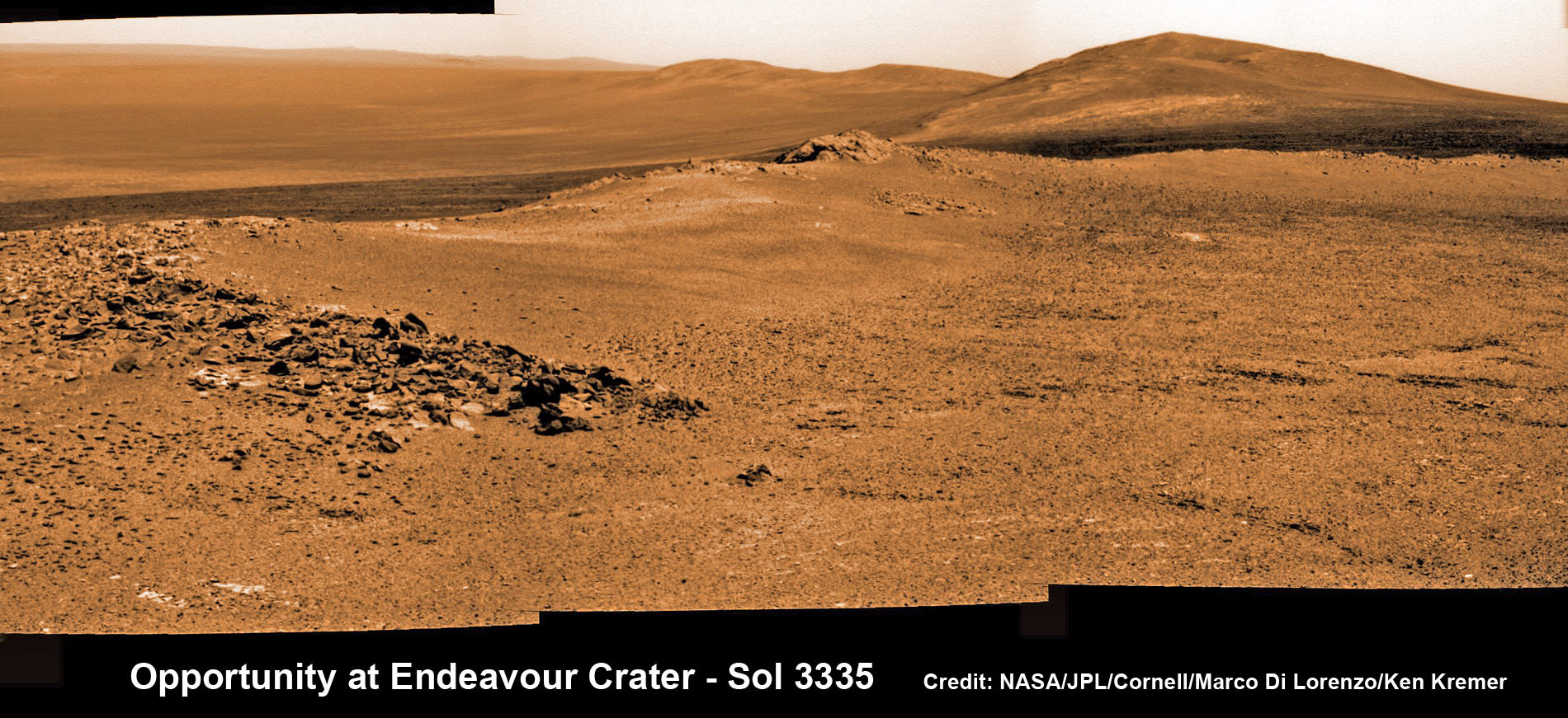
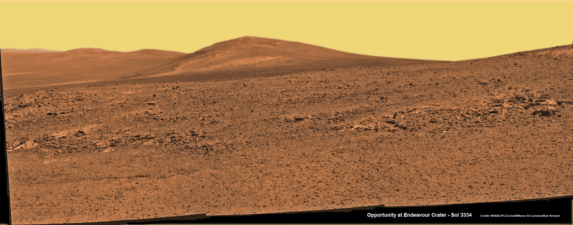
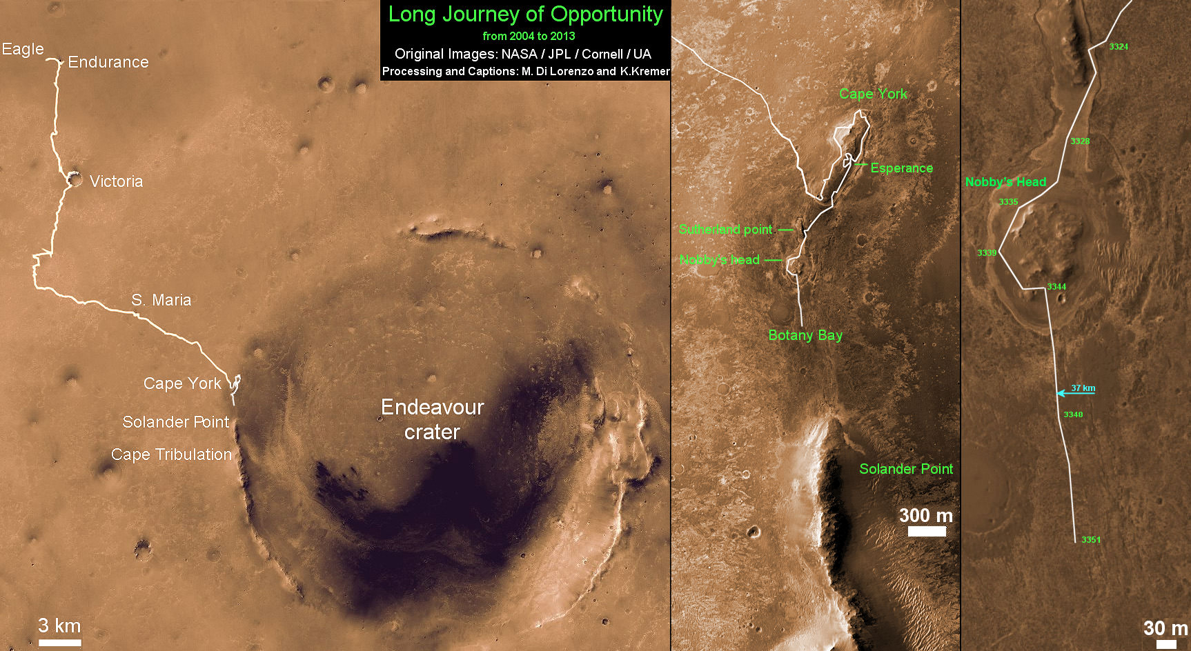
Opportunity rover captures spectacular view ahead to her upcoming mountain climbing goal, the raised rim of “Solander Point” at right, located along the western edge of Endeavour Crater. It may harbor clay minerals indicative of a habitable zone. This pancam photo mosaic was taken on Sol 3335, June 11, 2013. Credit: NASA/JPL/Cornell/ASU/Marco Di Lorenzo/Ken Kremer (kenkremer.com) See full panoramic scene below
Opportunity rover captures spectacular view ahead to her upcoming mountain climbing goal, the raised rim of “Solander Point” at right, located along the western edge of Endeavour Crater. It may harbor clay minerals indicative of a habitable zone. This pancam photo mosaic was taken on Sol 3335, June 11, 2013. Credit: NASA/JPL/Cornell/ASU/Marco Di Lorenzo/Ken Kremer (kenkremer.com)
See full panoramic scene – below Your last chance to “Send Your Name to Mars aboard NASA’s MAVEN orbiter” – below[/caption]
NASA’s nearly decade old Opportunity Mars rover is sailing swiftly on a southerly course towards her first true mountain climbing destination – named “Solander Point” – in search of further evidence of habitable environments with the chemical ingredients necessary to sustain Martian life forms.
At Solander Point, researchers have already spotted deep stacks of ancient rocks transformed by flowing liquid water eons ago. It is located along the western rim of huge Endeavour Crater.
“Right now the rover team is discussing the best way to approach and drive up Solander,” Ray Arvidson told Universe Today. Arvidson is the mission’s deputy principal scientific investigator from Washington University in St. Louis, Mo.
Solander Point may harbor clay minerals in the rock stacks indicative of a past Martian habitable zone.
“One idea is to drive part way up Solander from the west side of the rim, turn left and then drive down the steeper north facing slopes with the stratographic sections,” Arvidson told me.
“That way we don’t have to drive up the relatively steeper slopes. The rover can drive up rocky surfaces inclined about 12 to 15 degrees.”
“We want to go through the stratographic sections on the north facing sections.”
Solander Point mosaic captured by high resolution pancam camera on Sol 3334, June 10, 2013. Opportunity will scale Solander after arriving in August 2013 in search of chemical ingredients to sustain Martian microbes Credit: NASA/JPL/Cornell/ASU/Marco Di Lorenzo/Ken Kremer (kenkremer.com)
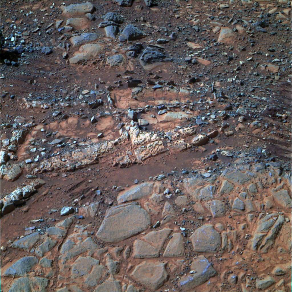
The science team hopes that by scaling Solander, Opportunity will build on her recent historic discovery of a habitable environment at a rock called “Esperance” that possesses a cache of phyllosilicate clay minerals.
These aluminum rich clay minerals typically form in neutral, drinkable water that is not extremely acidic or basic and therefore could support a path to potential Martian microbes.
“Esperance ranks as one of my personal Top 5 discoveries of the mission,” said Steve Squyres of Cornell University, Ithaca, N.Y., principal investigator for NASA’s rover mission at a recent media briefing.
‘Esperance’ Target Examined by Opportunity in May 2013. The pale rock called “Esperance,” has a high concentration of clay minerals formed in near neutral water indcating a spot favorable for life. Credit: NASA/JPL-Caltech/Cornell Univ./Arizona State Univ.
Using high resolution CRISM spectral data collected from Mars orbit, the rover was specifically directed to Esperance, Arvidson explained. The rock was found about a kilometer back on Matijevic Hill at ‘Cape York’, a rather low hilly segment of the western rim of giant Endeavour crater which spans 14 miles (22 km) across.
‘Solander Point’ offers roughly about a 10 times taller stack of geological layering compared to ‘Cape York.’ Both areas are raised segments of the western rim of Endeavour Crater.
The team is working now to obtain the same type of high resolution spectral evidence for phyllosilicate clay minerals at Solander as they had at Cape York to aid in targeting Opportunity to the most promising outcrops, Arvidson explained.
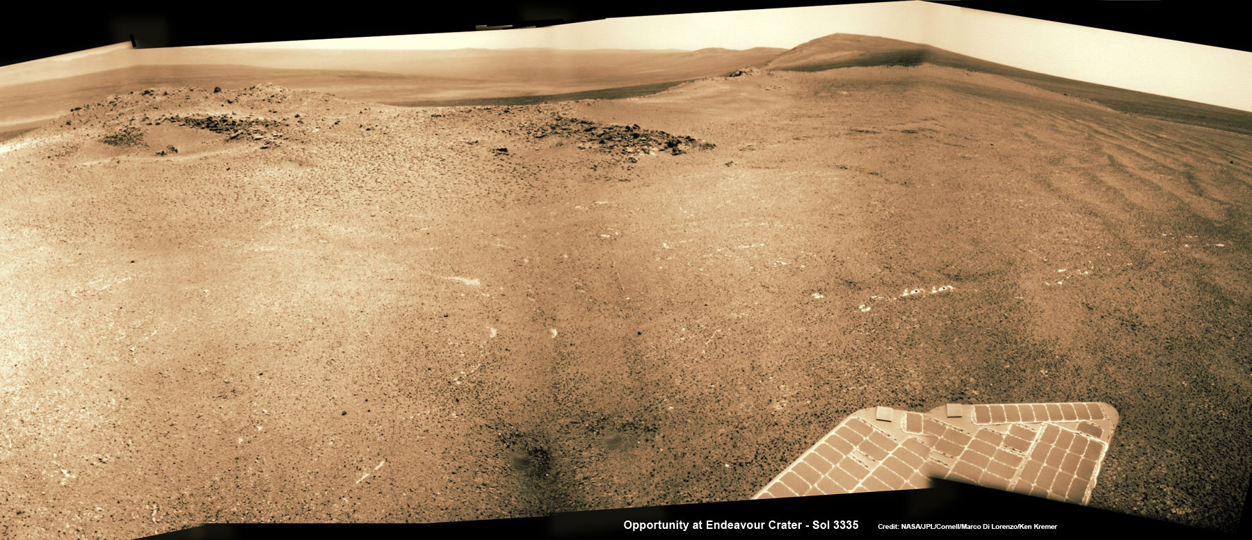
Opportunity is snapping ever more spectacular imagery of Solander Point and the eroded rim of Endeavour Crater as she approaches closer every passing Sol, or Martian Day. See our original photo mosaics herein by Marco Di Lorenzo and Ken Kremer.
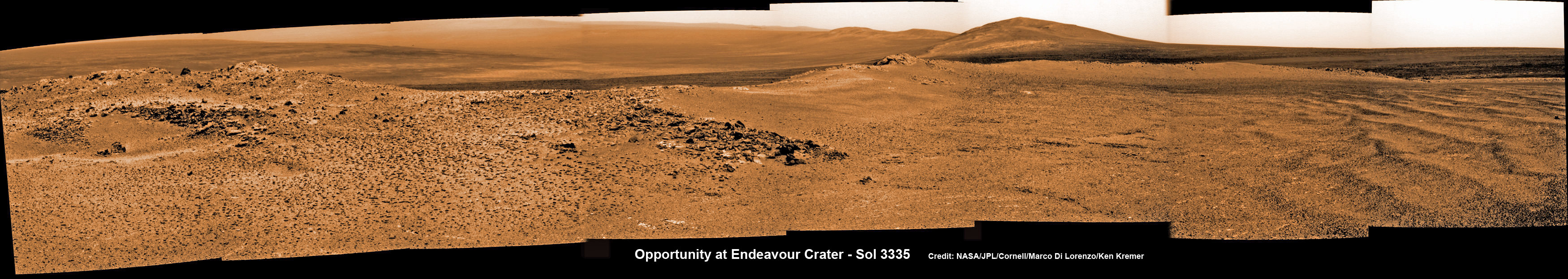
Opportunity captures spectacular panoramic view ahead to her upcoming mountain climbing goal, the raised rim of “Solander Point” at right, located along the western edge of Endeavour Crater. It may harbor clay minerals indicative of a habitable zone. The rise at left is “Nobbys Head” which the rover just passed on its southward drive to Solander Point from Cape York. This pancam photo mosaic was taken on Sol 3335, June 11, 2013 shows vast expanse of the central crater mound and distant Endeavour crater rim.
Credit: NASA/JPL/Cornell/ASU/Marco Di Lorenzo/Ken Kremer (kenkremer.com)
The long lived robot arrived at the edge of Endeavour crater in mid-2011 and will spend her remaining life driving around the scientifically rich crater rim segments.
On June 21, 2013, Opportunity marked five Martian years on Mars since landing on Jan 24, 2004 with a mere 90 day (Sol) ‘warranty’.
This week Opportunity’s total driving distance exceeded 23 miles (37 kilometers).
The solar powered robot remains in excellent health and the life giving solar arrays are producing plenty of electrical power at the moment.
Solander Point also offers northerly tilled slopes that will maximize the power generation during Opportunity’s upcoming 6th Martian winter .
The rover handlers want Opportunity to reach Solander’s slopes by August, before winter’s onset.
As ot today (tosol) Opportunity has trekked about halfway from Cape York to Solander Point – tip to tip.
On the opposite side of Mars at Gale Crater, Opportunity’s younger sister rover Curiosity also discovered clay minerals and a habitable environment originating from a time when the Red Planet was far warmer and wetter billions of years ago.
And this is your last chance to “Send Your Name to Mars” aboard NASA’s MAVEN orbiter- details here. Deadline: July 1, 2013. Launch: Nov. 18, 2013
Wide angle view of Endeavour Crater showing Solander Point and Cape Tribulation in this photo mosaic captured by navcam camera on Sol 3335, June 11, 2013. Opportunity will scale Solander after arriving in August 2013 in search of chemical ingredients to sustain Martian microbes. Credit: NASA/JPL/Cornell/Marco Di Lorenzo/Ken Kremer (kenkremer.com)Traverse Map for NASA’s Opportunity rover from 2004 to 2013. This map shows the entire path the rover has driven during more than 9 years and over 3351 Sols, or Martian days, since landing inside Eagle Crater on Jan 24, 2004 to current location heading south to Solander Point from Cape York ridge at the western rim of Endeavour Crater. Credit: NASA/JPL/Cornell/ASU/Marco Di Lorenzo/Ken Kremer
Screenshot showing the Shenzou-10 capsule on the ground following a successful mission for China.
China successfully completed its longest human space mission as the Shenzhou-10 spacecraft and its crew of two men and one woman returned safely to Earth. The return capsule landed via parachute at 8:07 am local time (0007 UTC) Wednesday, June 26, 2013 on the grasslands of north China’s Inner Mongolia region. The 15-day “Divine Vessel” mission is part of the Chinese space program’s objective of building a permanent space station by 2020.
In the video below, enthusiastic applause comes when the parachute deploys and at other milestones of the return. The crew was quickly greeted and a smiling Nie Haisheng, the commander of the mission, emerged from the capsule first, and was followed by female astronaut Wang Yaping, and crewmember Zhang Xiaoguang.
“At this moment what I most want to say is that space is our dream and our motherland is forever our home,” Nie said. “I wish our motherland to thrive even more and our people to become happier and happier. I thank the entire nation for their concern and support for us.”
During the mission, the Shenzou spacecraft docked with China’s orbiting space module Tiangong-1 in tests intended to prepare for the building of the space station. The crew also spoke via video to school children in China, showing how different objects behave in zero-G. The crew conducted several experiments and medical tests while in space. The official mission duration was 14 days 14 hours and 29 minutes.
This was China’s fifth manned space mission since 2003. China plans to launch the Tiangong-2 space lab around 2015, according to the official Chinese Xinhua news agency, quoting Wang Zhaoyao, director of China’s manned space program office. He said there are plans to put an experimental core module of a space station in orbit in 2018, with the manned space station itself being built around 2020.
Besides building a space station, China also hopes to send astronauts to the Moon.
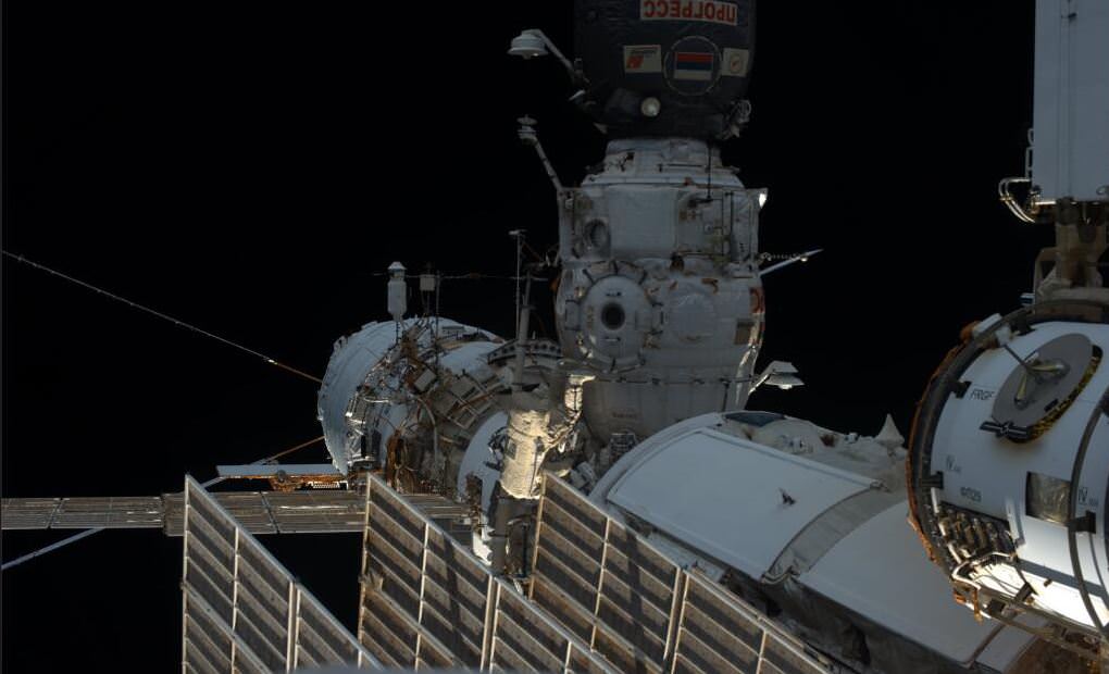
A view of Aleksandr Misurkin during the spacewalk to prepare the International Space Station for a new Russian lab. Image via astronaut Karen Nyberg/NASA.
On Monday, two Russian cosmonauts conducted a 6-hour, 34-minute spacewalk to prepare for a new Russian module that will be launched later this year. Expedition 36 Flight Engineers Fyodor Yurchikhin and Alexander Misurkin also work on the first module ever launched for the ISS – the Zarya module which has been in space since 1998 – replacing an aging control panels located on the exterior.
The new lab will be a combination research facility, airlock and docking port, and is planned to launch late this year on a Proton rocket.
Watch video highlights of the EVA below:
This was the second of up to six Russian spacewalks planned for this year to prepare for the lab. Two U.S. spacewalks by NASA’s Chris Cassidy and Luca Parmitano of the European Space Agency are scheduled in July.
While Yurchikhin and Misurkin worked outside the ISS, the crew inside the ISS were separated and isolated from each other. Cassidy and station commander Pavel Vinogradov were sequestered in their Soyuz TMA-08M spacecraft that is attached to the Poisk module on the Russian segment due to the closure of hatches to the other passageways on the Russian side of the station which would have made the Soyuz inaccessible if there was an emergency. Parmitano and US astronaut Karen Nyberg were inside the U.S. segment of the station, and were free to move around since entry to their Soyuz vehicle (TMA-09M) was not blocked by hatch closures, since it is docked to the Rassvet module that is attached to the Zarya module.
NASA said the spacewalk was the 169th in support of space station assembly and maintenance, the sixth for Yurchikhin and the first for Misurkin.
On June 24, 2013 a pair of daytime sounding rockets will launch from NASA Wallops Flight Facility (WFF) and deploy a chemical trail like the one deployed here from a sounding rocket at night. The chemical trail will help researchers track wind movement to determine how it affects the movement of charged particles in the atmosphere. All the colors in the sky shown here, the white and blue streaks, and the larger red blob overhead, are from the chemical trails. Credit: NASA
On June 24, 2013 a pair of daytime sounding rockets will launch from NASA Wallops Flight Facility (WFF) and deploy a chemical trail like the one deployed here from a sounding rocket at night. The chemical trail will help researchers track wind movement to determine how it affects the movement of charged particles in the atmosphere. All the colors in the sky shown here, the white and blue streaks, and the larger red blob overhead, are from the chemical trails. Credit: NASA See Rocket Visibility Maps below[/caption]
NASA WALLOPS, VA – Science and space aficionados are in for rare treat on June 24 when NASA launches a two-rocket salvo from the NASA Wallops Flight Facility, Va. on a mission to study how charged particles in the ionosphere can disrupt communication signals that impact our day to day lives.
It’s a joint project between NASA and the Japanese Space Agency, or Japan Aerospace Exploration Agency, or JAXA.
The suborbital sounding rockets will blast off merely 15 seconds apart from a beach-side launch complex directly on Virginia’s Eastern shore on a science mission named the Daytime Dynamo.
An electric current called the dynamo, illustrated here, sweeps through Earth’s upper atmosphere.A pair of sounding rockets called Dynamo will launch on June 24, to study the current, which can disrupt Earth’s communication and navigation signals. Credit: USGSLithium gas will be deployed from one of the rockets to create a chemical trail that can be used to track upper atmospheric winds that drive the dynamo currents.
The goal is to study the global electrical current called the dynamo, which sweeps through the ionosphere, a layer of charged particles that extends from about 30 to 600 miles above Earth.
Why should you care?
Because disruptions in the ionosphere can scramble radio wave signals for communications and navigations transmissions from senders to receivers – and that can impact our every day lives.
The experiment involves launching a duo of suborbital rockets and also dispatching an airplane to collect airborne science measurements.
Mission control and the science team will have their hands full coordinating the near simultaneous liftoffs of two different rockets with two different payloads while watching the weather to make sure its optimal to collect the right kind of data that will answer the research proposal.
A single-stage Black Brant V will launch first. The 35 foot long rocket will carry a 600 pound payload to collect the baseline data to characterize the neutral and charged particles as it swiftly travels through the ionosphere.
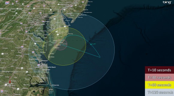
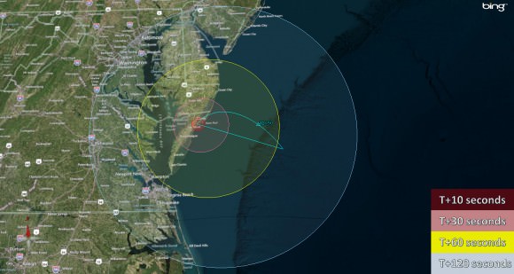
Visibility map for Black Brant V rocket launch on June 24 at 9:30 a.m. Credit: NASA Wallops
A two-stage Terrier-Improved Orion blasts off just 15 seconds later. The 33 foot long rocket carries a canister of lithium gas. It will shoot out a long trail of lithium gas that creates a chemical trail that will be tracked to determine how the upper atmospheric wind varies with altitude. These winds are believed to be the drivers of the dynamo currents.
Visibility map for Terrier-Improved Orion rocket launch on June 24 at 9:30 a.m. Credit: NASA Wallops
Both rockets will fly for about five minutes to an altitude of some 100 miles up in the ionosphere.
Since its daytime the lithium trails will be very hard to discern with the naked eye. That’s why NASA is also using a uniquely equipped NASA King Air airplane outfitted with cameras with special new filters optimized to detect the lithium gas and how it is moved by the winds that generate the global electrical current.
The new technology to make the daytime measurements was jointly developed by NASA, JAXA and scientists at Clemson University.
RockOn 2013 University student payload blasts off on June 20,2013 atop a NASA Terrier-Improved Orion suborbital rocket from NASA Wallops at Virginia’s eastern shore. Credit: NASA/Chris Perry
Sounding rockets are better suited to conduct these studies of the ionosphere compared to orbiting satellites which fly to high.
“The manner in which neutral and ionized gases interact is a fundamental part of nature,” said Robert Pfaff, the principle investigator for the Dynamo sounding rocket at NASA’s Goddard Space Flight Center in Greenbelt, Md.
“There could very well be a dynamo on other planets. Jupiter, Saturn, Uranus and Neptune are all huge planets with huge atmospheres and huge magnetic fields. They could be setting up dynamo currents galore.”
The launch window opens at 9:30 a.m. and extends until 11:30 a.m. Back up opportunities are available on June 25 and from June 28 to July 8.
The rockets will be visible to residents in the Wallops region – and also beyond to the US East Coast from parts of North Carolina to New Jersey.
The NASA Wallops Visitor Center will open at 8 a.m. on launch day for viewing the launches.
Live coverage of the June 24 launch is available via NASA Wallops UStream beginning at 8:30 a.m. at: http://www.ustream.tv/channel/nasa-tv-wallops
I will be onsite at Wallops for Universe Today.
And don’t forget to “Send Your Name to Mars” aboard NASA’s MAVEN orbiter- details here. Deadline: July 1, 2013. Launch: Nov. 18, 2013
…………….
Learn more about Earth, Mars, Curiosity, Opportunity, MAVEN, LADEE, Sounding rockets and NASA missions at Ken’s upcoming presentation
June 23: “Send your Name to Mars on MAVEN” and “CIBER Astro Sat, LADEE Lunar & Antares Rocket Launches from Virginia”; Rodeway Inn, Chincoteague, VA, 8 PM
Show here are the two types of sounding rockets that will launch on June 24, 2013 from NASA Wallops Island, VA., on the Daytime Dynamo mission. Black Brant V rocket is horizontal. Terrier-Improved Orion rocket is vertical. Credit: Ken Kremer – kenkremer.comNight time launch of NASA Black Brant XII suborbital rocket at 11:05 p.m. EDT on June 5, 2013 from the NASA Wallops Flight Facility carrying the CIBER astronomy payload. Credit: Ken Kremer- kenkremer.com
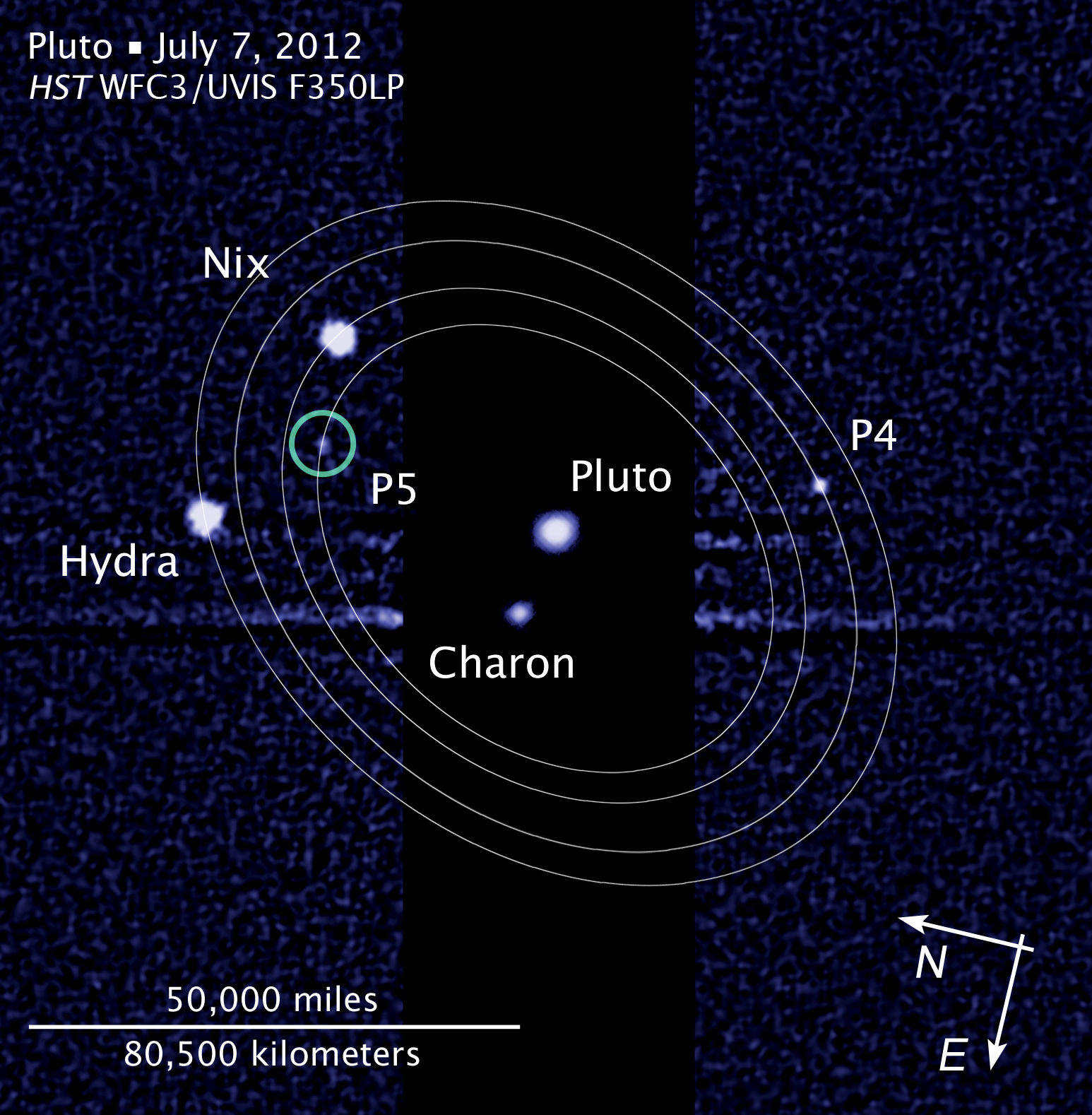
The Pluto and Charon Binary Planet System imaged by the Hubble Space Telescope. NASA’s New Horizons spacecraft will pass through in 2015 using the original baseline trajectory . Credit: Hubble Space Telescope
Following an intense 18 month study to determine if NASA’s New Horizons spacecraft faced potentially destructive impact hazards during its planned 2015 flyby of the Pluto binary planet system, the mission team has decided to ‘stay the course’ – and stick with the originally planned trajectory because the danger posed by dust and debris is much less than feared.
The impact assessment study was conducted because the Pluto system was discovered to be much more complex – and thus even more scientifically compelling – after New Horizons was launched in January 2006 from Cape Canaveral in Florida.
Two years ago researchers using the iconic Hubble Space Telescope discovered two new moons orbiting around Pluto, bringing the total to 5 moons!
It was feared that debris hitting the moons could have created dangerous dust clouds that in turn would slam into and damage the spacecraft as it zoomed past Pluto at speeds of some 30,000 miles per hour (more than 48,000 kilometers per hour) in July 2015.
“We found that loss of the New Horizons mission by dust impacting the spacecraft is very unlikely, and we expect to follow the nominal, or baseline, mission timeline that we’ve been refining over the past few years,” says New Horizons Project Scientist Hal Weaver, of the Johns Hopkins University Applied Physics Laboratory, in a statement.
After both the team and an independent review board and NASA thoroughly analyzed the data, it was determined that New Horizons has only a 0.3 percent chance of suffering a mission destroying dust impact event using the baseline trajectory.
Hubble Space Telescope view of Pluto and its known moons.
The 0.3 percent probability of mission loss is far less than some earlier estimates.
This is really good news because the team can focus most of its efforts on developing the flyby encounter science plan when New Horizons swoops to within about 12,500 kilometers (nearly 7,800 miles) of Pluto’s surface.
Pluto forms a “double planet” system with Charon, its largest moon. Charon is half the size of Pluto.
But the team will still expend some effort on developing alternative trajectories – known as SHBOTs, short for Safe Haven by Other Trajectories, just in case new information arises from the ships camera observations that would force a change in plans as New Horizons sails ever closer to Pluto.
“Still, we’ll be ready with two alternative timelines, in the event that the impact risk turns out to be greater than we think,” says Weaver.
Indeed the team, led by Principal Investigator Alan Stern, of the Southwest Research Institute is finalizing the encounter plan this month and plans a rehearsal in July of the most critical nine-day segment of the baseline flyby trajectory.
New Horizons will perform the first reconnaissance of Pluto and Charon in July 2015. The “double planet” is the last planet in our solar system to be visited by a spacecraft from Earth.
And New Horizons doesn’t’ stop at Pluto. The goal is to explore one or more of the icy Kuiper Belt Objects (KBO’s) further out in the Solar System.
The team will use the Pluto flyby to redirect New Horizons to a KBO that is yet to be identified.
And don’t forget to “Send Your Name to Mars” aboard NASA’s MAVEN orbiter- details here. Deadline: July 1, 2013. Launch: Nov. 18, 2013
…………….
Learn more about Pluto, Mars, Curiosity, Opportunity, MAVEN, LADEE and NASA missions at Ken’s upcoming lecture presentations
June 23: “Send your Name to Mars on MAVEN” and “CIBER Astro Sat, LADEE Lunar & Antares Rocket Launches from Virginia”; Rodeway Inn, Chincoteague, VA, 8 PM
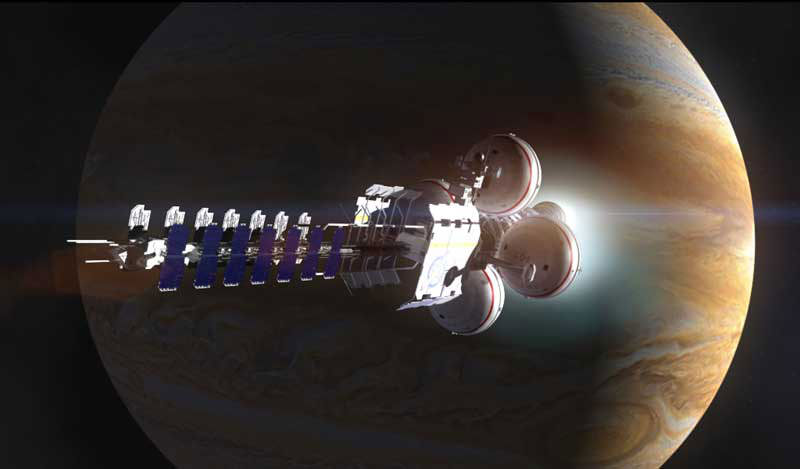
A spacecraft makes a close pass by Jupiter. Credit: Adrian Mann
Picture the scene: It’s the not too distant future and humanity has started to construct colonies and habitats all across our solar system. We’re gearing up to take that next big step into the unknown – actually leaving the cozy protection of the Sun’s heliosphere and venturing into interstellar space. Before this future can happen, however, there’s an important thing which is often overlooked in discussions on this subject.
Navigation.
Just as sailors once used the stars to navigate the sea, space travelers may be able to use the stars to navigate the solar system. Except that this time, the stars we’d use will be dead ones. A specific class of neutron stars known as pulsars, defined by the repeated pulses of radiation they emit. The trick, according to a recent paper, may be to use pulsars as a form of interplanetary – and possibly even interstellar – GPS.
Theories and ideas on spacecraft engines are plentiful. Foundations such as Icarus Interstellar keenly advocate the development of new propulsion systems, with some systems such as the VASIMR thrusters appearing rather promising. Meanwhile, fusion rockets are expected to be able to take passengers on a round trip from Earth to Mars in just 30 days, and researchers elsewhere are working on real life warp drives, not unlike the ones we all know and love from the movies.
Interplanetary GPS
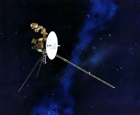
For Voyager 2, out on the edge of our Solar system, conventional navigation methods don’t work too well. Credit: NASA
But navigation is just as important. After all, space is mind-meltingly vast and mostly empty. The prospect of getting lost out in the emptiness is, frankly, terrifying.
To date, this hasn’t really been a problem, particularly seeing as we’ve only sent a small handful of craft past Mars. As a result, we currently use a messy mishmash of techniques to keep track of spacecraft from here on Earth – essentially tracking them with telescopes while relying heavily on their planned trajectory. This is also only as accurate as our instruments here on Earth are, meaning that as a craft gets more distant, our idea of where exactly it is becomes increasingly less accurate.
This is all well and good when we only have a few craft to track, but when space travel becomes more easily attainable and human passengers are involved, routing everything through Earth will start to become more and more difficult. This is particularly the case if we’re planning on leaving the confines of our home star – Voyager 2 is presently over 14 light hours away, meaning that Earth-based transmissions take over half a day to reach it.
Navigating Earth with modern technology is quite simple thanks to the array of GPS satellites we have in orbit around our world. Those satellites are constantly transitting signals which are, in turn, received by the GPS unit you may have on your car dashboard or in your pocket. As with all other electromagnetic transmissions, those signals travel at the speed of light, giving a slight delay between when they were transmitted and when they’re received. By using the signals from 4 or more satellites and timing those delays, a GPS unit can pinpoint your location on the surface of Earth with remarkable accuracy.
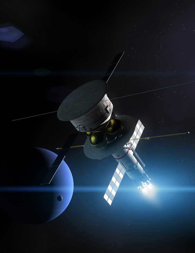
The Icarus Pathfinder starship passing by Neptune. Credit: Adrian Mann
The pulsar navigation system proposed by Werner Becker, Mike Bernhardt, and Axel Jessner at the Max Planck Institute, works in a very similar way, using the pulses emitted by pulsars. By knowing the initial position and velocity of your spacecraft, recording those pulses, and treating the Sun as a fixed reference point, you can calculate your exact location inside the solar system.
Considering the Sun to be fixed this way is technically referred to as an inertial reference frame, and if you compensate for the motion of the Sun through our galaxy, the system still works perfectly well when leaving the Solar system! All you need is to keep track of a minimum of 3 pulsars (ideally 10, for the most accurate results), and you can pinpoint your location with surprising accuracy!
Interestingly enough, the idea of using pulsars as navigation beacons dates all the way back to 1974, notably not long after Carl Sagan had used pulsars to show Earth’s location on the plaques attached to the Pioneer 10 and 11 space probes. If Project Daedalus had ever been constructed, it might have been equipped with a system not unlike the one described here.
Packing for long haul
Becker and his colleagues looked at the different types of pulsar visible in the sky, and picked out a type known as rotation-powered pulsars as the best type to use for a galactic positioning system. In particular, a sub-type of these known as millisecond pulsars are ideal. Being older than most pulsars they have weak magnetic fields, meaning they take a long time to slow down their spin rates – helpful as strongly magnetised pulsars can sometimes change their rotation speed without warning.
An x-ray image of the Vela pulsar, one of the brightest known millisecond pulsars. Credit: NASA/CXC/PSU/G.Pavlov et al.
With countless pulsars to choose from, the question turns to how you might equip your spacecraft to track them. Pulsars are easiest to spot in either x-rays or radio waves, so there’s a little choice as to which may be better to use. Essentially, it all turns out to be a question of how large your spacecraft is.
Smaller vehicles, more akin to modern spacecraft, would be best off using x-rays to track pulsars. X-ray mirrors, like the ones used in certain orbiting space telescopes are compact and lightweight, meaning that a few could be added for a navigation system without increasing the overall mass of the craft all that much. They may have the minor disadvantage that they may be easily damaged by an x-ray source which is too bright, this wouldn’t be a problem except under some unfortunate circumstances.
On the other hand, if you’re piloting a large space ship between planets or even stars, you would likely be better using radio waves. In radio frequencies, we know a lot more about the way in which pulsars work, as well as being able to measure them with a higher degree of accuracy. The only drawback there is that the radio telescopes you’d need to install on your ship would require an area of at least 150 m². But then, if you happened to be flying a starship, that kind of size probably wouldn’t make much difference.
It’s interesting to bear in mind the way that astronomers frequently use the analogy of pulsars being “like lighthouses” when explaining why they appear to pulse. If we someday find ourselves using them as actual navigation aids, that analogy may take on a whole new meaning!