Stratolaunch Systems Carrier Aircraft - Air Launch to Orbit Space Launch System. Developed by Scaled Composites, the aircraft manufacturer and assembler founded by Burt Rutan. The carrier will loft and drop the 500,000 multistage SpaceX rocket that will propel payloads to orbit at dramatically reduced costs. It will be the largest aircraft ever flown with a wing span of 385 feet and weighing 1.2 million pounds. Credit: Stratolaunch Systems. Watch complete video below.
[/caption]
A mega quartet of luminaries led by Microsoft co-founder Paul G. Allen and legendary aerospace designer Burt Rutan have joined forces to create a revolutionary new approach to space travel. This new privately funded venture entails the development of a mammoth air-launched space transportation system that aims to dramatically cut the high costs and risks of launching both cargo and human crews to low Earth orbit.
Allen and Rutan are teaming up with Elon Musk, founder of Space Exploration Technologies Corp, or SpaceX, and Michael Griffin, former NASA Administrator, to build the world’s largest aircraft ever flown and use it as a platform to loft a multi-stage SpaceX rocket that will deliver a payload of some 13,500 pounds into earth orbit, about the same class as a Delta II.
Allen and Rutan hope to build upon the spaceflight revolution that they pioneered with the suborbital SpaceShipOne in 2004, which was the first privately funded spaceship to reach the edge of space, and now take the critical next step and actually vault all the way to orbit.
Video Caption: Stratolaunch Systems is pioneering innovative solutions to revolutionize space transportation to orbit.
To accomplish this innovative leap, Allen and Rutan, announced the formation of a new company, funded by Allen, called Stratolaunch Systems at a press briefing today, Dec. 13, held in Seattle, WA. Allen is a billionaire and philanthropist who has funded a host of projects to advance science,
“Our national aspirations for space exploration have been receding,” Allen lamented at the start of the briefing. “This year saw the end of NASA’s space shuttle program. Constellation, which would have taken us back to the moon, has been mothballed as well. For the first time since John Glenn, America cannot fly its own astronauts into space.”
“With government funded spaceflight diminishing, there’s a much expanded opportunity for privately funded efforts.”
Rutan said that Stratolaunch will build a 1.2 million pound carrier aircraft sporting a wingspan of 385 feet – longer than a football field – and which will be powered by six 747 engines on takeoff. The carrier will be a twin fuselage vehicle, like the WhiteKnight developed by Rutan to launch SpaceShipOne.
Air launch of SpaceX rocket to orbit
The 120 foot long SpaceX rocket, weighing up to 490,000 pounds, will be slung in between and dropped at an altitude of about 30,000 feet for the remaining ascent to orbit.
SpaceX will construct a shorter, less powerful version of the firms existing Falcon 9 rocket, which may be either a Falcon 4 or Falcon 5 depending on specifications.
The new launch system will operate from a large airport or spaceport like the Kennedy Space Center, require a 12,000 feet long runway for takeoff and landing and be capable of flying up to 1,300 nautical miles to the payload’s launch point. Crews aboard the huge carrier aircraft will also conduct the countdown and firing of the booster and will monitor payload blasting to orbit.
“I have long dreamed about taking the next big step in private space flight after the success of SpaceShipOne – to offer a flexible, orbital space delivery system,” Allen said. “We are at the dawn of radical change in the space launch industry. Stratolaunch Systems is pioneering an innovative solution that will revolutionize space travel.”
The goal of Stratolaunch is to “bring airport-like operations to the launch of commercial and government payloads and, eventually, human missions,” according to a company statement.
Plans call for a first orbital flight within five years by around 2016. Test flights could begin around 2015.
“We believe this technology has the potential to someday make spaceflight routine by removing many of the constraints associated with ground launched rockets,” said Mike Griffin. “Our system will also provide the flexibility to launch from a large variety of locations.”
Mike Griffin added that the venture is aiming for the small to medium class payload market similar to what has been served by the venerable Delta II rocket, which is now being retired after decades of service.
“At some point this vehicle could loft a crew of say six people,” Griffin stated.
“This is an exciting day,” concluded Allen.
“Stratolaunch will keep America at the forefront of space exploration and give tomorrow’s children something to search for in the night sky and dream about. Work has already started on our project at the Mojave Spaceport.”
SpaceX Dragon cargo spaceship propels commercial and science payloads to orbit following air-launch from gigantic carrier aircraft. Credit: Stratolaunch Systems
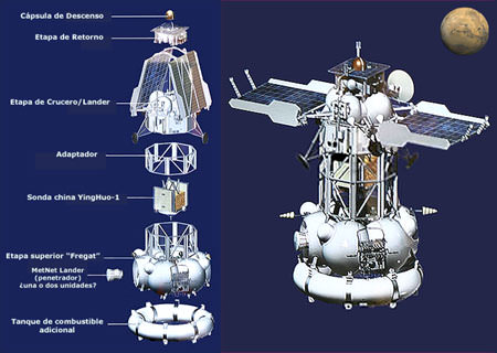
Configuration of the Phobos-Grunt spacecraft. Credit: NPO Lavochkin
Configuration of the Phobos-Grunt spacecraft. Credit: NPO Lavochkin
Editor’s note: Dr. David Warmflash, principal science lead for the US team from the LIFE experiment on board the Phobos-Grunt spacecraft, provides an update on the mission for Universe Today.
As last-ditch efforts to recover control of the unpiloted Phobos-Grunt spacecraft continue, officials, engineers, and scientists at the Russian Federal Space Agency (Roscosmos) have shifted their focus to the issue of reentry. Launched November 9 by a Zenit-2 rocket on a mission to return a sample from Phobos, the larger of Mars’ two small moons, the spacecraft reached low Earth orbit. However, since the engine of the upper stage that was to propel it on a trajectory to Mars failed to ignite, the spacecraft continues to orbit Earth in a low orbit. Despite some limited success in communicating with Phobos-Grunt by way of tracking stations that the European Space Agency (ESA) operates in Perth, Australia, and Masplalomas, Canary Islands, the spacecraft remains stranded in an orbit whose decay will take the craft into the atmosphere sometime in early January. Continue reading “Russian Space Program Prepares for Phobos-Grunt Re-Entry”
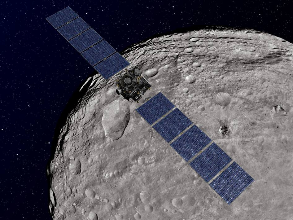
Dawn Orbiting Vesta. This artist's concept shows NASA's Dawn spacecraft orbiting the giant asteroid Vesta. The depiction of Vesta is based on images obtained by Dawn's framing cameras. Dawn is an international collaboration of the US, Germany and Italy. Credit: NASA/JPL-Caltech
[/caption]
NASA’s Dawn Asteroid Orbiter successfully spiraled down today to the closest orbit the probe will ever achieve around the giant asteroid Vesta, and has now begun critical science observations that will ultimately yield the mission’s highest resolution measurements of this spectacular body.
“What can be more exciting than to explore an alien world that until recently was virtually unknown!” Dr. Marc Rayman gushed in an exclusive interview with Universe Today. Rayman is Dawn’s Chief Engineer from NASA’s Jet Propulsion Lab (JPL) in Pasadena, Calif., and a protégé of Star Trek’s Mr. Scott.
Before Dawn, Vesta was little more than a fuzzy blob in the world’s most powerful telescopes. Vesta is the second most massive object in the main Asteroid Belt between Mars and Jupiter.
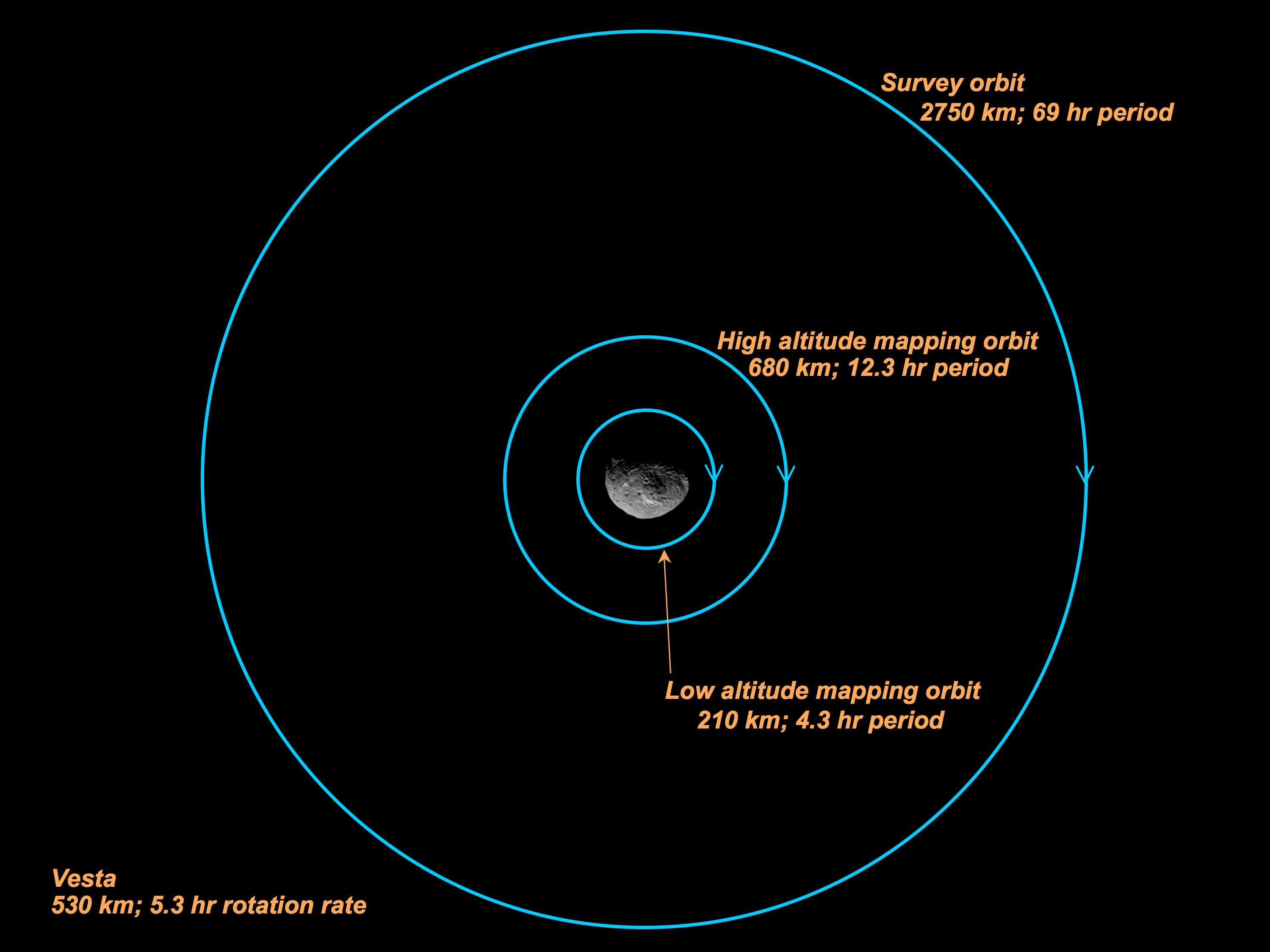
Dawn is now circling about Vesta at the lowest planned mapping orbit, dubbed LAMO for Low Altitude Mapping Orbit. The spacecraft is orbiting at an average altitude of barely 130 miles (210 kilometers) above the heavily bombarded and mysterious world that stems from the earliest eons of our solar system some 4.5 Billion years ago. Each orbit takes about 4.3 hours.
“It is both gratifying and exciting that Dawn has been performing so well,” Rayman told me.
Dawn Orbiting Over Vesta - A Hi Res Taste of What's Ahead!
This image of the giant asteroid Vesta was obtained by Dawn in the evening Nov. 27 PST (early morning Nov. 28, UTC), as it was spiraling down from its high altitude mapping orbit to low altitude mapping orbit. Low altitude mapping orbit is the closest orbit Dawn will be making, at an average of 130 miles (210 kilometers) above the giant asteroid's surface. The framing camera obtained this image of an area in the northern mid-latitudes of Vesta from an altitude of about 140 miles (230 kilometers). Credit: NASA/JPL-Caltech/UCLA/MPS/DLR/IDA
Dawn arrived in orbit at Vesta in July 2011 after a nearly 4 year interplanetary cruise since blasting off atop a Delta II rocket from Cape Canaveral, Florida in September 2007. The probe then spent the first few weeks at an initial science survey altitude of about 1,700 miles (2,700 kilometers).
Gradually the spaceship spiraled down closer to Vesta using her ion propulsion thrusters.
See Vesta science orbit diagram, below, provided courtesy of Dr. Marc Rayman.
Along the way, the international science and engineering team commanded Dawn to make an intermediate stop this past Fall 2011 at the High Altitude Mapping orbit altitude (420 miles, or 680 kilometers).
“It is so cool now to have reached this low orbit [LAMO]. We already have a spectacular collection of images and other fascinating data on Vesta, and now we are going to gain even more,” Rayman told me.
“We have a great deal of work ahead to acquire our planned data here, and I’m looking forward to every bit!
Dawn will spend a minimum of 10 weeks acquiring data at the LAMO mapping orbit using all three onboard science instruments, provided by the US, Germany and Italy.
While the framing cameras (FC) from Germany and the Visible and Infrared Mapping spectrometer (VIR) from Italy will continue to gather mountains of data at their best resolution yet, the primary science focus of the LAMO orbit will be to collect data from the gamma ray and neutron detector (GRaND) and the gravity experiment.
GRaND will measure the elemental abundances on the surface of Vesta by studying the energy and neutron by-products that emanate from it as a result of the continuous bombardment of cosmic rays. The best data are obtained at the lowest altitude.
Dawn spacecraft - Science orbits at Vesta
Credit: NASA/JPL-Caltech/Marc Rayman
By examining all the data in context, scientists hope to obtain a better understanding of the formation and evolution of the early solar system.
Vesta is a proto-planet, largely unchanged since its formation, and whose evolution into a larger planet was stopped cold by the massive gravitational influence of the planet Jupiter.
“Dawn’s visit to Vesta has been eye-opening so far, showing us troughs and peaks that telescopes only hinted at,” said Christopher Russell, Dawn’s principal investigator, based at UCLA. “It whets the appetite for a day when human explorers can see the wonders of asteroids for themselves.”
After investigating Vesta for about a year, the engineers will ignite Dawn’s ion propulsion thrusters and blast away to Ceres, the largest asteroid which may harbor water ice and is another potential outpost for extraterrestrial life
Dawn will be the first spaceship to orbit two worlds and is also the first mission to study the asteroid belt in detail.
Asteroid Vesta from Dawn - Exquisite Clarity from a formerly Fuzzy Blob
NASA's Dawn spacecraft obtained this image of the giant asteroid Vesta with its framing camera on July 24, 2011. It was taken from a distance of about 3,200 miles (5,200 kilometers). Before Dawn, Vesta was just a fuzzy blob in the most powerful telescopes. Dawn entered orbit around Vesta on July 15, and will spend a year orbiting the body before firing up the ion propulsion system to break orbit and speed to Ceres, the largest Asteroid. Credit: NASA/JPL-Caltech/UCLA/MPS/DLR/IDASouth Polar Region of Vesta - Enhanced View
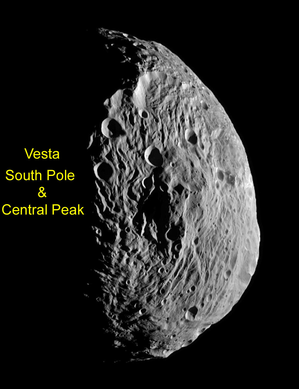
An ancient cosmic collision blasted away much of the south pole of Vesta, leaving behind an enoumous mountain about 3 times the height of Mt. Everest. NASA's Dawn spacecraft obtained this image centered on the south pole of Vesta with its framing camera on July 18, 2011 as it passed the terminator. The image has been enhanced to bring out more surface details. It was taken from a distance of about 6,500 miles (10,500 kilometers) away from the protoplanet Vesta. The smallest detail visible is about 1.2 miles (2.0 km). Credit: NASA/JPL-Caltech/UCLA/MPS/DLR/IDA. Enhanced and annotated by Ken Kremer
Read continuing features about Dawn by Ken Kremer starting here:
An artists concept of the Phobos-Grunt Mission. Credit: Roscosmos
[/caption]
Editor’s note: Dr. David Warmflash, principal science lead for the US team from the LIFE experiment on board the Phobos-Grunt spacecraft, provides an update on the mission for Universe Today.
It has been trapped in low Earth orbit for more than a month. So low is the orbit that it moves too fast to be contacted – unless controllers on the ground just happen to beam a signal at some unlikely angle. So short does its battery power last that it must be in sunlight while also in position to receive signals. Then, it must still have power to send telemetry back to the ground.
Even with these obstacles, Russia’s Phobos- Grunt probe did manage to communicate with the European Space Agency’s (ESA) antenna in Perth, Australia twice a couple of weeks ago, indicating that some of its systems were functioning. But subsequent attempts at communication have failed, despite the addition of ESA’s Canary Islands antenna at Maspalomas to the worldwide effort to reestablish control over the spacecraft.
Tracking of Grunt’s orbit has shown that its high point (apogee) and low point (perigee) continue to decrease, measuring about 289 kilometers and 203 kilometers in altitude, respectively, the last time I checked. Stories out of Russia in recent days describe how electrical cables found to be malfunctioning weeks before the launch were cut and connections re-soldered in a hurry to have the craft ready. Add to this the fact that the major sources on developments with the Grunt mission since its November 9 launch – Ria Novosti, the Russian Space Web, and ESA operations – all expect the craft to reenter Earth’s atmosphere in early January.
Taking all of this into account, it seems unlikely that Phobos-Grunt will ever respond to a signal again and say, “privyet’, much less turn on its engines and warp out of orbit. But there is an opportunity coming, a period when the odds that are stacked against the spacecraft may improve just a little.
Beginning Tuesday, December 13 at 17:00 universal time (UT) to Wednesday December 14, 23:00, Phobos-Grunt will be in sunlight throughout its entire orbit. It is not completely clear whether or not ESA will attempt to contact the probe during this period from Perth, or Maspalomas. Although attempts from Maspalomas were made throughout last week, the same attempts were scheduled to end on Friday, December 9. On the other hand, in a letter informing scientists participating in the mission that failure was the outcome, Phobos-Grunt science director, Lev Zelenyi, wrote: “Lavochkin Association specialists will continue their attempts to establish connection with the spacecraft and send commands until the very end of its existence.” Thus, despite the fact that the Russian Grunt team now is focused on the issue of reentry, we should not be surprised if they ask ESA to make one more attempt on Tuesday.
Will the greater than usual amount of sunlight allow the spacecraft’s communication system to work better than it usually does when it travels over tracking stations? Maybe yes, and maybe no. We should not get our hopes up that the craft will actually do anything but fall to Earth, and we’ve already discussed the possibility of the craft’s return capsule coming back in one piece.
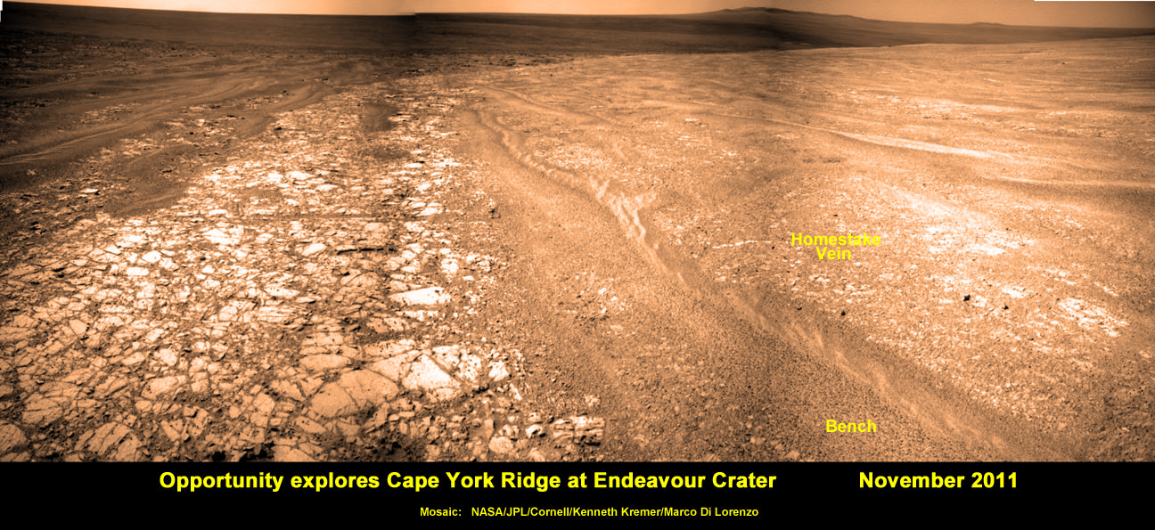
Opportunity discovers Water related mineral vein at Endeavour Crater - November 2011. Opportunity rover discovered Gypsum at the Homestake mineral vein, while exploring around the base of Cape York ridge at the rim of Endeavour Crater. The vein is composed of calcium sulfate and indicates the ancient flow of liquid water at this spot on Mars. Opportunity drove North (ahead) from here in search of a sunny winter haven. Credit: NASA/JPL/Cornell/Kenneth Kremer/Marco Di Lorenzo
[/caption]
NASA’s long lived Opportunity rover has discovered the most scientifically compelling evidence yet for the flow of liquid water on ancient Mars. The startling revelation comes in the form of a bright vein of the mineral gypsum located at the foothills of an enormous crater named Endeavour, where the intrepid robot is currently traversing. See our mosaic above, illustrating the exact spot.
Update: ‘Homestake’ Opportunity Mosaic above has just been published on Astronomy Picture of the Day (APOD) – 12 Dec 2011 (by Ken Kremer and Marco Di Lorenzo)
Researchers trumpeted the significant water finding this week (Dec. 7) at the annual winter meeting of the American Geophysical Union (AGU) in San Francisco.
“This gypsum vein is the single most powerful piece of evidence for liquid water at Mars that has been discovered by the Opportunity rover,” announced Steve Squyres of Cornell University, Ithaca, N.Y., Principal Investigator for Opportunity, at an AGU press conference.
The light-toned vein is apparently composed of the mineral gypsum and was deposited as a result of precipitation from percolating pools of liquid water which flowed on the surface and subsurface of ancient Mars, billions of years ago. Liquid water is an essential prerequisite for life as we know it.
“This tells a slam-dunk story that water flowed through underground fractures in the rock,” said Squyres. “This stuff is a fairly pure chemical deposit that formed in place right where we see it. That can’t be said for other gypsum seen on Mars or for other water-related minerals Opportunity has found. It’s not uncommon on Earth, but on Mars, it’s the kind of thing that makes geologists jump out of their chairs.”
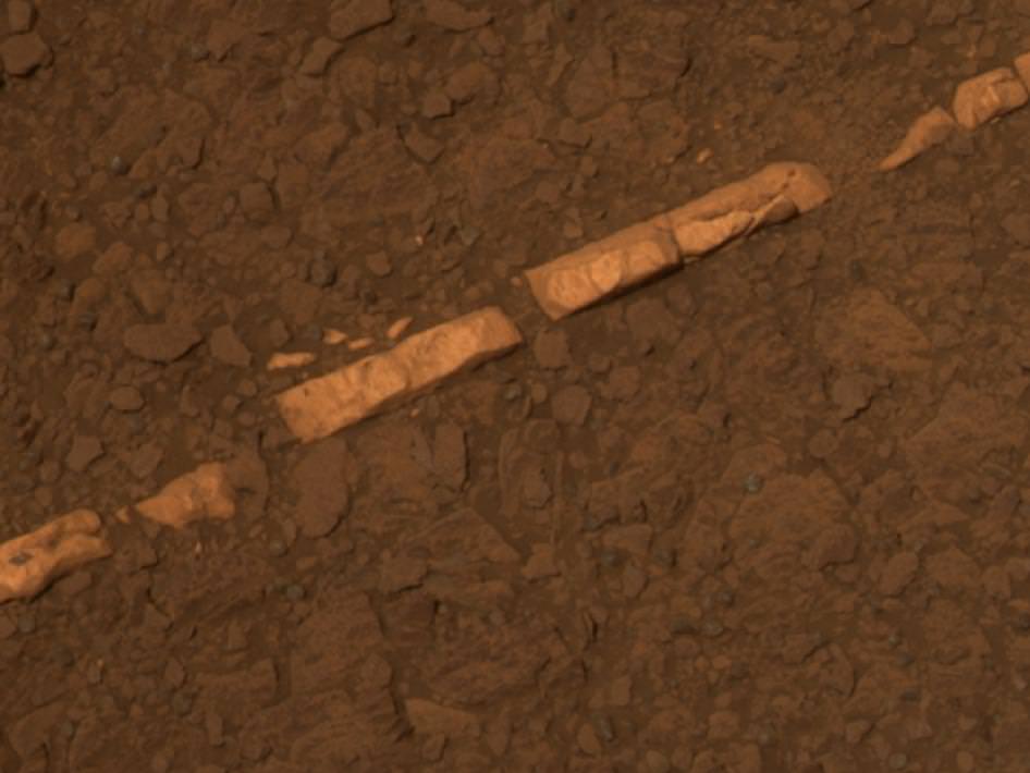
'Homestake' Vein in Color and Close-up
This color view of a mineral vein called "Homestake" was taken by the panoramic camera (Pancam) on NASA's Mars Exploration Rover Opportunity. The vein is about the width of a thumb and about 18 inches (45 centimeters) long. Opportunity examined it in November 2011 and found it to be rich in calcium and sulfur, possibly the calcium-sulfate mineral gypsum.
The light-toned vein is informally named “Homestake”, and was examined up close by Opportunity’s cameras and science instruments for several weeks this past month in November 2011, as the rover was driving northwards along the western edge of a ridge dubbed ‘Cape York’ – which is a low lying segment of the eroded rim of Endeavour Crater.
Veins are a geologic indication of the past flow of liquid water
Opportunity just arrived at the rim of the 14 mile (22 kilometere) wide Endeavour Crater in mid-August 2011 following an epic three year trek across treacherous dune fields from her prior investigative target at the ½ mile wide Victoria Crater.
“It’s like a whole new mission since we arrived at Cape York,” said Squyres.
‘Homestake’ is a very bright linear feature.
“The ‘Homestake’ vein is about 1 centimeter wide and 40 to 50 centimeters long,” Squyres elaborated. “It’s about the width of a human thumb.”
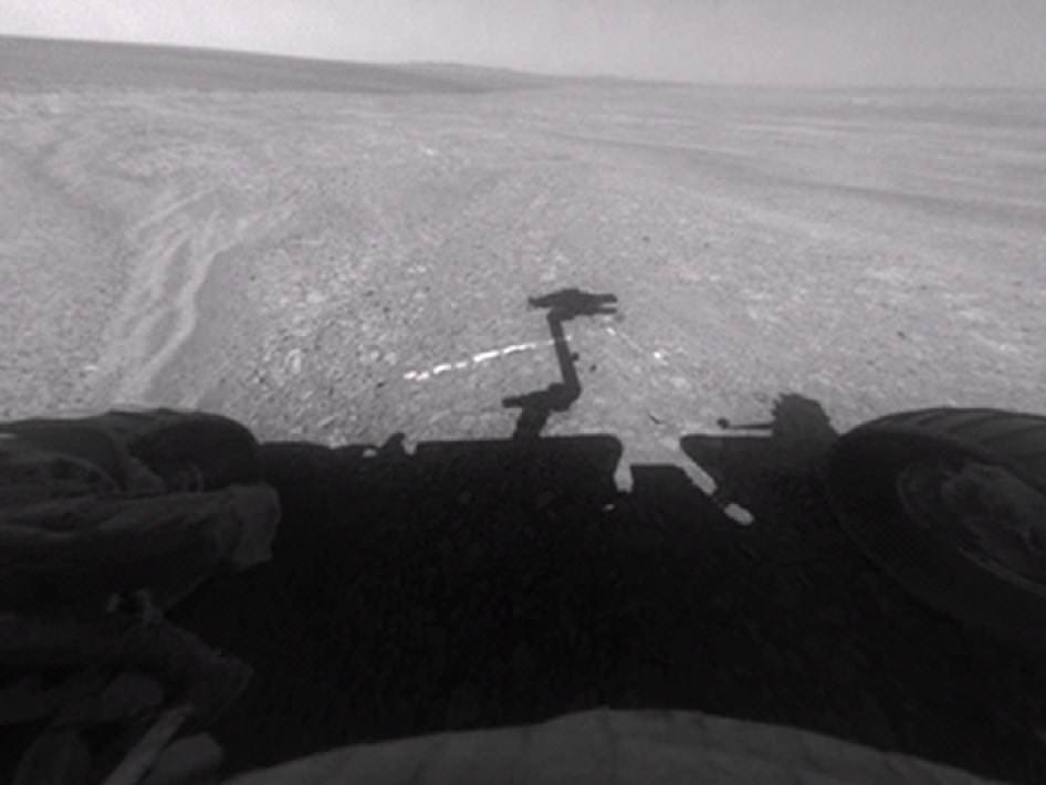
Opportunity's Approach to 'Homestake'
This view from the front hazard-avoidance camera on NASA's Mars Exploration Rover Opportunity shows the rover's arm's shadow falling near a bright mineral vein informally named Homestake. The vein is about the width of a thumb and about 18 inches (45 centimeters) long. Opportunity examined it in November 2011 and found it to be rich in calcium and sulfur, possibly the calcium-sulfate mineral gypsum. Opportunity took this image on Sol 2763 on Mars (Nov. 7, 2011). Credit: NASA/JPL-Caltech
Homestake protrudes slightly above the surrounding ground and bedrock and appears to be part of a system of mineral veins running inside an apron (or Bench) that in turn encircles the entire ridge dubbed Cape York.
In another first, no other veins like these have been seen by Opportunity throughout her entire 20 miles (33 kilometers) and nearly eight year long Martian journey across the cratered, pockmarked plains of Meridiani Planum, said Squyres.
The veins have also not been seen in the higher ground around the rim at Endeavour crater.
“We want to understand why these veins are in the apron but not out on the plains,” said the mission’s deputy principal investigator, Ray Arvidson, of Washington University in St. Louis. “The answer may be that rising groundwater coming from the ancient crust moved through material adjacent to Cape York and deposited gypsum, because this material would be relatively insoluble compared with either magnesium or iron sulfates.”
Opportunity was tasked to engage her Microscopic Imager and Alpha Particle X-ray Spectrometer (APXS) mounted on the terminus of the rover’s arm as well as multiple filters of the mast mounted Panoramic Camera to examine ‘Homestake’.
“The APXS spectrometer shows ’Homestake’ is chock full of Calcium and Sulfur,” Squyres gushed.
Microscopic Close-up View of 'Homestake' Vein
This close-up view of a mineral vein called Homestake comes from the microscopic imager on Opportunity. The vein is about the width of a thumb and about 18 inches (45 centimeters) long. Opportunity examined it in November 2011 and found it to be rich in calcium and sulfur, possibly the calcium-sulfate mineral gypsum. Homestake is near the edge of the "Cape York" segment of the western rim of Endeavour Crater. This view blends three exposures taken by the microscopic imager during the 2,765th and 2,766th Martian days, or sols, of Opportunity's career on Mars (Nov. 3 and 4, 2011). Credit: NASA/JPL-Caltech/Cornell/USGS
The measurements of composition with the APXS show that the ratio points to it being relatively pure calcium sulfate, Squyres explained. “One type of calcium sulfate is gypsum.”
Calcium sulfate can have varying amounts of water bound into the minerals crystal structure.
The rover science team believes that this form of gypsum discovered by Opportunity is the dihydrate; CaSO4•2H2O. On Earth, gypsum is used for making drywall and plaster of Paris.
The gypsum was formed in the exact spot where Opportunity found it – unlike the sulfate minerals previously discovered which were moved around by the wind and other environmental and geologic forces.
“There was a fracture in the rock, water flowed through it, gypsum was precipitated from the water. End of story,” Squyres noted. “There’s no ambiguity about this, and this is what makes it so cool.”
At Homestake we are seeing the evidence of the ground waters that flowed through the ancient Noachian rocks and the precipitation of the gypsum, which is the least soluble of the sulfates, and the other magnesium and iron sulfates which Opportunity has been driving on for the last 8 years.
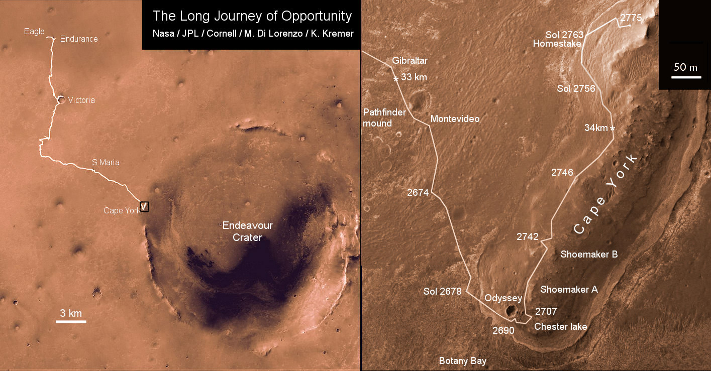
Opportunity Traverse Map 2004 to 2011
Traverse map showing the 8 Year Journey of Opportunity from Eagle Crater landing site Sol 1 (Jan. 24, 2004) to Sol 2775 (November 2011). Map shows rover location around Homestake water related mineral on Sol 2763 (November 2011) at Cape York ridge at Endeavour Crater rim. Endeavour Crater is 14 miles or 22 kilometers in diameter. Opportunity has driven more than 21 miles (34 km).
Credit: NASA/JPL/Cornell/Marco Di Lorenzo/Kenneth Kremer
“Here, both the chemistry, mineralogy, and the morphology just scream water,” Squyres exclaimed. “This is more solid than anything else that we’ve seen in the whole mission.”
It’s inconceivable that the vein is something else beside gypsum, said Squyres.
As Opportunity drove from the plains of Meridiani onto the rim of Endeavour Crater and Cape York, it crossed a geologic boundary and arrived at a much different and older region of ancient Mars.
The evidence for flowing liquid water at Endeavour crater is even more powerful than the silica deposits found by Spirit around the Home Plate volcanic feature at Gusev Crater a few years ago.
“We will look for more of these veins in the [Martian] springtime,” said Squyres.
If a bigger, fatter vein can be found, then Opportunity will be directed to grind into it with her still well functioning Rock Abrasion Tool, or RAT.
Homestake was crunched with the wheels – driving back and forth over the vein – to break it up and expose the interior. Opportunity did a triple crunch over Homestake, said Arvidson.
Homestake was found near the northern tip of Cape York, while Opportunity was scouting out a “Winter Haven” location to spend the approaching Martian winter.
Arvidson emphasized that the team wants Opportunity to be positioned on a northerly tilted slope to catch the maximum amount of the sun’s rays to keep the rover powered up for continuing science activities throughout the fast approaching Martian winter.
“Martian winter in the southern hemisphere starts on March 29, 2012. But, Solar power levels already begin dropping dramatically months before Martian winter starts,” said Alfonso Herrera to Universe Today, Herrera is a Mars rover mission manager at NASA’s Jet Propulsion Laboratory in Pasadena, Calif.
“Opportunity is in excellent health,” said Bruce Banerdt, the Project Scientist for the Mars rover mission at JPL.
“This has been a very exciting time. We’ll head back south in the springtime and have a whole bunch of things to do with a very capable robot,” Squyres concluded.
'Botany Bay' and 'Cape York' with Vertical Exaggeration
This graphic combines a perspective view of the "Botany Bay" and "Cape York" areas of the rim of Endeavour Crater on Mars, and an inset with mapping-spectrometer data. Major features are labeled. In the perspective view, the landscape's vertical dimension is exaggerated five-fold compared with horizontal dimensions. NASA's Mars Exploration Rover Opportunity examined targets in the Cape York area during the second half of 2011. The perspective view was generated by producing an elevation map from a stereo pair of images from the High Resolution Imaging Science Experiment (HiRISE) camera on NASA's Mars Reconnaissance Orbiter, then draping one of the HiRISE images over the elevation model. The inset presents data from the Compact Reconnaissance Imaging Spectrometer for Mars (CRISM) instrument on the Mars Reconnaissance Orbiter. In this CRISM observation, taken on March 29, 2011 Thermal inertia estimates from observations by the Thermal Emission Imaging System on NASA's Mars Odyssey orbiter indicate that Botany Bay is a region with extensive outcrop exposures. Credit: NASA/JPL-Caltech/UA/JHUAPL
Meanwhile, NASA’s next leap in exploring potential Martian habitats for life – the car sized Curiosity Mars Science Lab rover – is speeding towards the Red Planet.
Read Ken’s continuing features about Opportunity starting here:
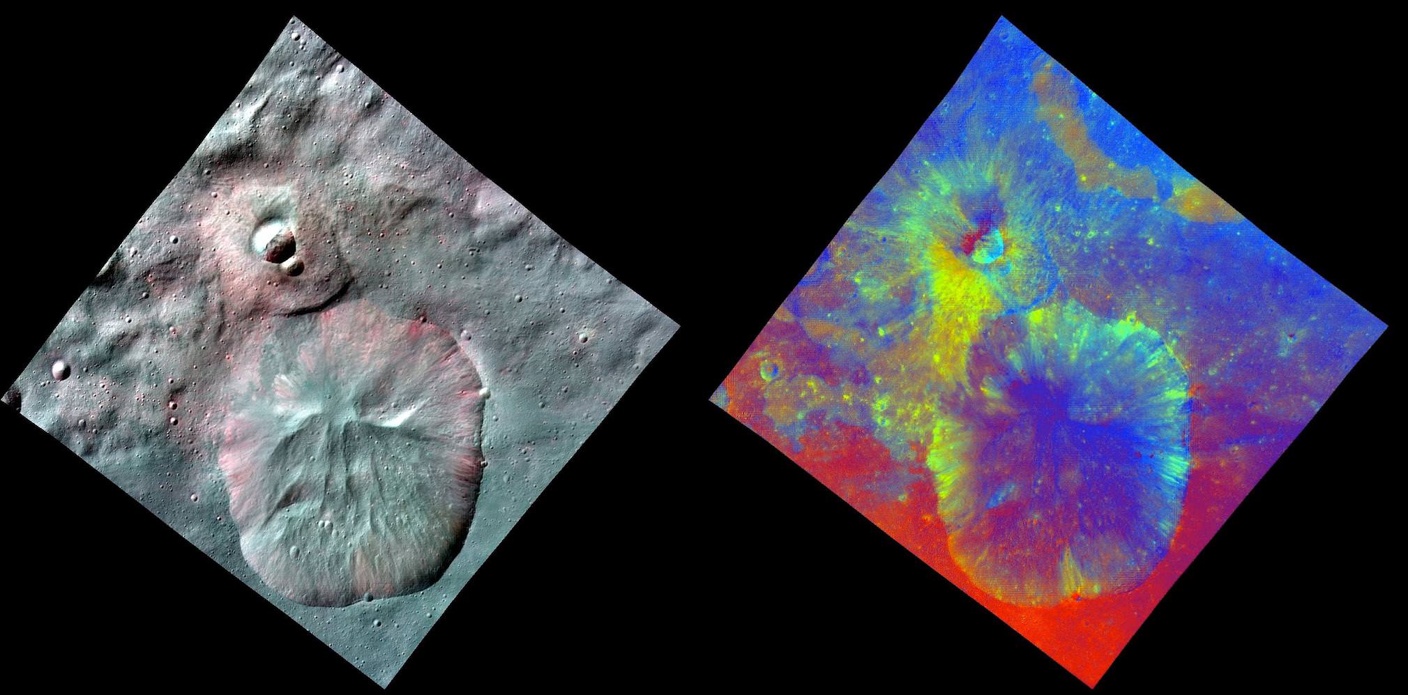
'Rainbow-Colored Palette' of Southern Hemisphere of Asteroid Vesta from NASA Dawn Orbiter. This mosaic using color data obtained by the framing camera aboard NASA's Dawn spacecraft shows Vesta's southern hemisphere in false color, centered on the Rheasilvia impact basin, about 290 miles (467 kilometers) in diameter with a central mound reaching about 14 miles (23 kilometers) high. The black hole in the middle is data that have been omitted due to the angle between the sun, Vesta and the spacecraft. The green areas suggest the presence of the iron-rich mineral pyroxene or large-sized particles. This mosaic was assembled using images obtained during Dawn's approach to Vesta, at a resolution of 480 meters per pixel. The German Aerospace Center and the Max Planck Institute for Solar System Research provided the Framing Camera instrument and funding as international partners on the mission team. Credit: NASA/JPL-Caltech/UCLA/MPS/DLR/IDA
[/caption]
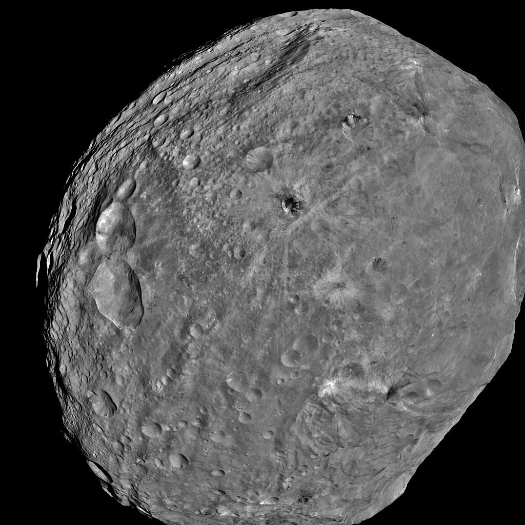
The giant Asteroid Vesta is among the most colorful bodies in our entire solar system and it appears to be much more like a terrestrial planet than a mere asteroid, say scientists deciphering stunning new images and measurements of Vesta received from NASA’s revolutionary Dawn spacecraft. The space probe only recently began circling about the huge asteroid in July after a four year interplanetary journey.
Vesta is a heavily battered and rugged world that’s littered with craters and mysterious grooves and troughs. It is the second most massive object in the Asteroid Belt and formed at nearly the same time as the Solar System some 4.5 Billion years ago.
“The framing cameras show Vesta is one of the most colorful objects in the solar system,” said mission scientist Vishnu Reddy of the Max Planck Institute for Solar System Research in Katlenburg-Lindau, Germany. “Vesta is unlike any other asteroid we have visited so far.”
Scientists presented the new images and findings from Dawn at the American Geophysical Union meeting this week in San Francisco.
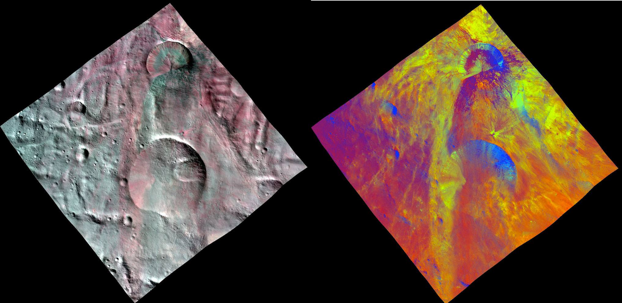
Comparative View of Terrains on Vesta - Oppia Crater
This image of Oppia Crater combines two separate views of the giant asteroid Vesta obtained by Dawn's framing camera. The far-left image uses near-infrared filters where red is used to represent 750 nanometers, green represents 920 nanometers and blue represents 980 nanometers. The image on the right is an image with colors assigned by scientists, representing different rock or mineral types on Vesta. The data reveal a world of many varied, well-separated layers and ingredients. The reddish color suggests a steep visible spectral slope, and areas of fresh landslides in the inner walls of the crater show deeper green colors. Credit: NASA/JPL-Caltech/UCLA/MPS/DLR/IDA
“Vesta is a transitional body between a small asteroid and a planet and is unique in many ways,” Reddy said. “We do not know why Vesta is so special.”
Although many asteroids look like potatoes, Reddy said Vesta reminds him more of an avocado.
Asteroid Vesta is revealed as a ‘rainbow-colored palette’ in a new image mosaic (above) showcasing this alien world of highly diverse rock and mineral types of many well-separated layers and ingredients.
Researchers assigned different colors as markers to represent different rock compositions in the stunning new mosaic of the asteroid’s southern hemisphere.
The green areas in the mosaic suggest the presence of the iron-rich mineral pyroxene or large-sized particles, according to Eleonora Ammannito, from the Visible and Infrared (VIR) spectrometer team of the Italian Space Agency. The ragged surface materials are a mixture of rapidly cooled surface rocks and a deeper layer that cooled more slowly.
What could the other colors represent?
“The surface is very much consistent with the variability in the HED (Howardite-Eucritic-Diogenite) meteorites,” Prof. Chris Russell, Dawn Principal Investigator (UCLA) told Universe Today in an exclusive interview.
“There is Diogenite in varying amounts.”
“The different colors represent in part different ratios of Diogenite to Eucritic material. Other color variation may be due to particle sizes and to aging,” Russell told me.
No evidence of volcanic materials has been detected so far, said David Williams, Dawn participating scientist of Arizona State University, Tucson. Fresh Impact Craters on Asteroid Vesta
The fresh impact craters in this view are located in the south polar region, which has been partly covered by landslides from the adjacent crater. This would suggest that a layer of loose material covers the Vesta surface. This image combines two separate views of the giant asteroid Vesta obtained by Dawn’s framing camera. The far-left image uses near-infrared filters where red is used to represent 750 nanometers, green represents 920 nanometers and blue represents 980 nanometers. Credit: NASA/JPL-Caltech/UCLA/MPS/DLR/IDA
Before Dawn arrived, researchers expected to observe indications of volcanic activity. So, the lack of findings of volcanism is somewhat surprising. Williams said that past volcanic activity may be masked due to the extensive battering and resultant mixing of the surface regolith.
“More than 10,000 high resolution images of Vesta have been snapped to date by the framing cameras on Dawn,” Dr. Marc Rayman told Universe Today. Rayman is Dawn’s Chief Engineer from NASA’s Jet Propulsion Lab (JPL) in Pasadena, Calif.
Dawn will spend a year in orbit at Vesta and investigate the asteroid at different altitudes with three on-board science instruments from the US, Germany and Italy.
The probe will soon finish spiraling down to her lowest mapping orbit known as LAMO (Low Altitude Mapping Orbit), approximately 130 miles (210 kilometers) above Vesta’s surface.
“Dawn remains on course to begin its scientific observations in LAMO on December 12,” said Rayman.
The German Aerospace Center and the Max Planck Institute for Solar System Research provided the Framing Camera instrument and funding as international partners on the mission team. The Visible and Infrared Mapping camera was provided by the Italian Space Agency.
In July 2012, Rayman and the engineering team will fire up Dawn’s ion propulsion system, break orbit and head to Ceres, the largest asteroid and what a number of scientists consider to be a planet itself.
Ceres is believed to harbor thick caches of water ice and therefore could be a potential candidate for life.
Southern Hemisphere of Vesta -Rheasilvia and Older Basin
Colorized shaded-relief map showing location of 375-kilometer-wide Older impact basin that is overlapping with the more recent 500 km (300 mi) wide Rheasilvia impact structure at asteroid Vesta’s South Pole. Credit: NASA/JPL-Caltech/UCLA/MPS/DLR/IDAAsteroid Vesta from Dawn - Exquisite Clarity from a formerly Fuzzy Blob
NASA's Dawn spacecraft obtained this image of the giant asteroid Vesta with its framing camera on July 24, 2011. It was taken from a distance of about 3,200 miles (5,200 kilometers). Before Dawn, Vesta was just a fuzzy blob in the most powerful telescopes. Dawn entered orbit around Vesta on July 15, and will spend a year orbiting the body before firing up the ion propulsion system to break orbit and speed to Ceres, the largest Asteroid. Credit: NASA/JPL-Caltech/UCLA/MPS/DLR/IDA
Read continuing features about Dawn by Ken Kremer starting here:
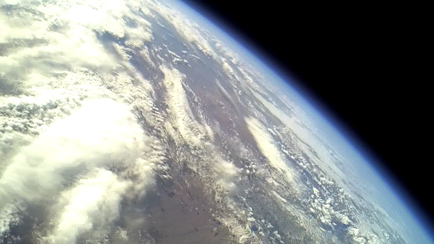
View of Earth above Spaceport America from Armadillo Aerospace STIG-A flight at apogee. Credit: Armadillo Aerospace
Over the weekend Armadillo Aerospace successfully launched an advanced sounding rocket from Spaceport America in New Mexico. The launch took place on Saturday, Dec. 3, 2011 at 11:00 a.m. (MST), and the STIG A rocket reached its expected sub-orbital altitude of 41.91 km (137,500 feet). Below is an image of Earth taken by a camera on board the rocket.
This latest launch is the thirteenth vertical launch test from the Spaceport America Vertical Launch Complex since 2006.
[/caption]
“This successful test of our “STIG A” reusable sub-orbital rocket technology represents major progress for the Armadillo Aerospace flight test program,” said Neil Milburn, Vice President of Program Management at Armadillo Aerospace. “The flight successfully demonstrated many of the technologies that we need for our manned sub-orbital program.”
The STIG is a long, sleek rocket designed for lower drag, high speed, high altitude flights. This rocket is aerodynamically optimized for high altitude flights with long 15 inches (38 cm) diameter cylindrical tanks instead of larger spherical tanks.
Armadillo requested that the test flight be a non-public, unpublished event, as the company is testing proprietary advanced launch technologies.
The company is one of the leading developers of reusable rocket-powered vehicles and plans to provide a platform for civilian access to suborbital space via a partnership with Space Adventures, Ltd. Armadillo Aerospace has flown over 200 flight tests with over a dozen different vehicles.
Armadillo Aerospace's STIG A rocket launches from Spaceport America. Credit: Space Adventures
On board the rocket was an experiment designed, built, tested, integrated, and performed by a team of undergraduate students at the School of Aeronautics and Astronautics in the College of Engineering at Purdue University. The experiment studied a liquid and gas flow process that is sensitive to the gravity and acceleration levels encountered during spaceflight.
“Spaceport America has been an ideal launch facility for this kind of vehicle R&D testing activity,” said John Carmack, President and CTO of Armadillo Aerospace.
Officials from the spaceport were please at the launch’s success as well.
“Spaceport America continues to set the precedent for safe, efficient, effective service for commercial spaceflight customers,” said NMSA Executive Director Christine Anderson. “We are extremely pleased to support Armadillo Aerospace as they conduct their high altitude vehicle flight testing, and look forward to hosting their NASA-funded suborbital research launches.”
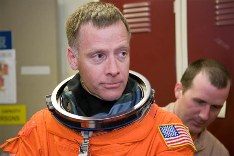
Chris Ferguson, the commander of the final mission of the shuttle program, STS-135 has announced that he will leave the space agency. Photo Credit: NASA.gov
[/caption]
On Dec. 9, 2011, NASA will witness the departure of the astronaut who served as commander for the final space shuttle mission STS-135. Chris Ferguson has announced his plans to retire from the space agency so that he can enter the private sector. With Ferguson’s departure, all of the commanders who flew the final three shuttle missions have left or will be departing NASA.
With no defined human space flight mission objectives in place and with the only ride to space currently being Russia’s Soyuz Spacecraft many astronauts are leaving the agency for other prospects. The space agency is losing an astronaut at the rate of one astronaut every two months. As of Dec. 9 NASA will have 58 astronauts in its active roster.
Ferguson has flown into space, twice on space shuttle Atlantis, logging over 40 days in space. Photo Credit: NASA.gov
Ferguson is a retired U.S. Navy captain – his command of Atlantis’ final flight marked his third trip into space. The 13-day mission was a resupply flight to the International Space Station and saw some 10,000 pounds of supplies and spare parts delivered to the orbiting outpost. With the final landing, conducted on July 21, 2011, Ferguson and his crew wrapped up the shuttle program’s 30 year history.
“Chris has been a great friend, a tremendous professional and an invaluable asset to the NASA team and the astronaut office,” said Peggy Whitson, chief of the Astronaut Office. “His exceptional leadership helped ensure a perfect final flight of the space shuttle,
a fitting tribute to the thousands who made the program possible.”
Ferguson (third from left) has opted to leave NASA to pursue a job in the private sector. His departure comes at a time when NASA is losing many of its experienced space flyers. Image Credit: NASA.gov
Ferguson’s very first mission, STS-115, was also on Atlantis. He served as the pilot on this mission which took place in 2006 and delivered the P3 and P4 truss segments to the space station. His next shuttle flight was STS-126 on shuttle Endeavour, this mission saw water reclamation and habitation systems transported to the ISS (as well as conducting a crew swap out). Ferguson has over 40 days of space flight experience.
Ferguson joined NASA’s astronaut corps in 1998. Upon his completion of initial astronaut training, he performed technical duties related to the shuttle’s main engines (SSMEs), the orbiter’s large, orange external tank, solid rocket boosters (SRBs) as well as software utilized on the shuttles. Before he was given the nod to be the commander of STS-135, Ferguson was the deputy chief of the Astronaut Office at NASA’s Johnson Space Center located in Houston, Texas.
“Chris has been a true leader at NASA,” said NASA Administrator Charles Bolden, “not just as a commander of the space shuttle, but also as an exemplary civil servant, a distinguished Navy officer and a good friend. I am confident he will succeed in his next career as he brings his skill and talents to new endeavors.”
Chris Ferguson has served NASA in a variety of roles since being accepted as an astronaut in 1998. Photo Credit: NASA.gov
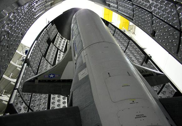
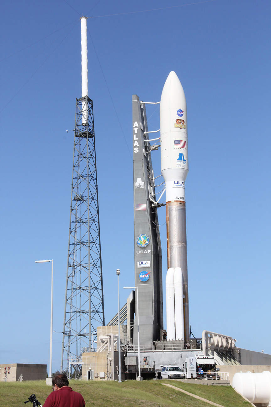
The Orbital Test Vehicle or OTV has been launched twice by the United States Air Force. There is one currently on orbit that has had its mission extended - past the officially stated endurance time that the USAF had previously announced. Photo Credit: USAF
Video provided courtesy of United Launch Alliance
The United States Air Force’s second flight of the X-37B – is headed into extra innings. Known as the Orbital Test Vehicle 2 (OTV-2) this robotic mini space shuttle launched from Cape Canaveral Air Force Station’s Space Launch Complex 41 (SLC-41) on Mar. 5, 2011. Although the U.S. Air Force has kept mum regarding details about the space plane’s mission – it has announced that the OTV-2 has exceeded its endurance limit of 270 days on orbit as of the end of November.
The OTV is launched atop a United Launch Alliance (ULA) Atlas V 501 rocket. The space plane is protected within a fairing until it reaches orbit. After separation, the diminutive shuttle begins its mission.
OTV mission USA-226, as it is officially known, is by all accounts going smoothly and the spacecraft is reported to be in good health. The U.S. Air Force has not announced when OTV-2 will be directed to land.
[/caption]
The fact that the space plane will continue to orbit beyond what its stated limits are highlights that the OTV has greater capabilities than what was officially announced. The first OTV flight launched in April of 2011 and landed 224 days later at Vandenberg Air Force Base in California. The U.S. Air Force is undoubtedly being more judicious with fuel stores on board the robotic spacecraft, allowing for a longer duration flight.
Much like NASA’s retired fleet of space shuttle orbiters, the OTV has a payload bay that allows for payloads and experiments to be conducted on-orbit. What payloads the U.S. Air Force has had on either mission – remains a secret.
Boeing has announced that the X-37B could be modified to conduct crewed missions to and from orbit. Tentatively named the X-37C, this spacecraft would be roughly twice the size of its unmanned cousin. If this variant goes into service it would be used to transport astronauts to and from the orbiting International Space Station (ISS).
OTV USA-226 launched on Mar. 5, 2011 and has helped prove out the mini space plane's design. Photo Credit: Alan Walters/awaltersphoto.com
The X-37B has become a bit controversial of late. Members of the Chinese press have stated that the space plane raises concerns of an arms race in space. Xinhua News Agency and China Daily have expressed concern that the OTVs could be used to deliver weapons to orbit. The Pentagon has flatly denied these allegations. The clandestine nature of these flights have led to a wide variety of theories as to what the OTVs have been used to ferry to orbit.
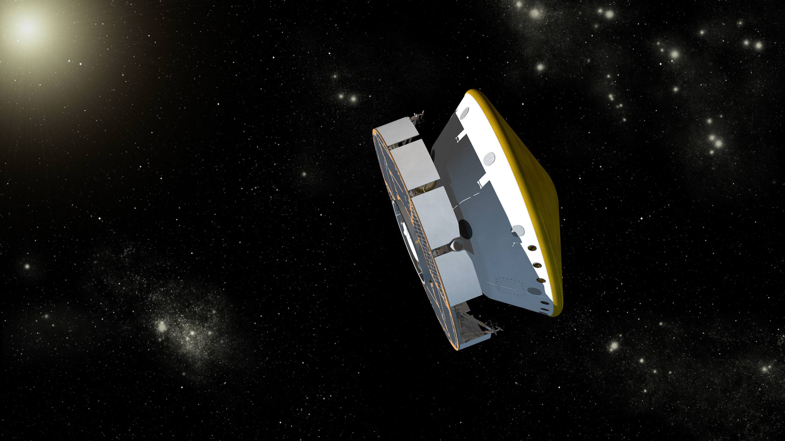
Curiosity Mars Science Laboratory Spacecraft During Cruise. Artist's concept of Curipsity during its cruise phase between launch on Nov. 26, 2011 and final approach to Mars in August 2012. The spacecraft includes a disc-shaped solar powered cruise stage (on the left) attached to the aeroshell (right). Curiosity and the descent stage are tucked inside the aeroshell. Along the way to Mars, the cruise stage will perform several trajectory correction maneuvers to adjust the spacecraft's path toward its final, precise landing site on Mars. Credit: NASA/JPL-Caltech
For a birds-eye view of where it all started, watch the cool close-up launch video, below taken from within the Atlas pad security fence.
Indeed the launch precision was so good that mission controllers at NASA’s Jet Propulsion Lab in Pasadsena, Calif., have announced they postponed the first of six planned course correction burns for the agency’s newest Mars rover by at least a month. The firing had been planned for some two weeks after liftoff.
Curiosity is merrily sailing on a 254 day and 352-million-mile (567-million-kilometer) interplanetary flight from the Earth to Mars that will culminate on August 6, 2012 with a dramatic first-of-its-kind precision rocket powered touchdown inside Gale Crater.
“This was among the most accurate interplanetary injections ever,” said Louis D’Amario of NASA’s Jet Propulsion Laboratory, Pasadena, Calif. He is the mission design and navigation manager for the Mars Science Laboratory.
Video Caption: View from inside the Pad 41 Security Fence at Cape Canaveral. Shot by a Canon 7D still camera during the launch of the Atlas V rocket carrying the MSL Curiosity rover to Mars. Thanks to a sound trigger my camera started firing at three frames per second from just after main engine ignition up until the exhaust plume finally envelops the camera and deadens all sound around it. The frames have been slowed down quite a bit for dramatic effect. Enjoy seeing what it is like for us media personnel who set out our remote cameras for launches at Kennedy Space Center and Cape Canaveral, Florida. Credit: Chase Clark/shuttlephotos.com
As of midday Friday, Dec. 2, the spacecraft had already traveled 10.8 million miles (17.3 million kilometers) and is moving at 7,500 mph (12,000 kilometers per hour) relative to Earth and at 73,800 mph (118,700 kilometers per hour) relative to the sun.
An interesting fact is that engineers deliberately planned the spacecraft’s initial trajectory to miss Mars by about 35,000 miles (56,400 kilometers) so that the Centaur upper stage does not hit Mars by accident. Both Centaur and Curiosity are currently following the same trajectory through the vast void of space and the actual trajectory puts them on course to miss Mars by about 38,000 miles (61,200 kilometers).
The Centaur has not been thoroughly cleaned of earthly microbes in the same way as Curiosity – and therefore cannot be permitted to impact the Martian surface and potentially contaminate the very studies Curiosity seeks to carry out in searching for the “Signs of Life”.
For the 8.5 month voyage to Mars, Curiosity and the rocket powered descent stage are tucked inside an aeroshell and are attached to the huge solar powered cruise stage.
Deceleration of Mars Science Laboratory in Martian Atmosphere
Artist's Concept depicts the interaction of NASA's Mars Science Laboratory spacecraft with the upper atmosphere of Mars during the entry, descent and landing (EDL) of the Curiosity rover onto the Martian surface. EDL begins when the spacecraft reaches the top of Martian atmosphere, about 81 miles (131 kilometers) above the surface of the Gale crater landing area, and ends with the rover safe and sound on the surface of Mars some 7 minutes later. During EDL, the spacecraft decelerates from a velocity of about 13,200 miles per hour (5,900 meters per second) at the top of the atmosphere, to stationary on the surface. Credit: NASA/JPL-Caltech
The cruise stage is rotating at 2.05 rounds per minutes and is continuously generating electric power – currently about 800 watts – from the gleaming solar arrays. It also houses eight miniature hydrazine fueled thrusters. The propellant is stored inside titanium tanks.
Atlas V rocket and Curiosity Mars rover poised at Space Launch Complex 41 at Cape Canaveral, Florida prior to Nov. 26, 2011 liftoff. Credit: Ken Kremer/kenkremer.com
The historic voyage of the largest and most sophisticated Martian rover ever built by humans seeks to determine if Mars ever offered conditions favorable for the genesis of microbial life.
Curiosity is packed to the gills with 10 state of the art science instruments that are seeking to detect the signs of life in the form of organic molecules – the carbon based building blocks of life as we know it.
The car sized robot is equipped with a drill and scoop at the end of its 7 ft long robotic arm to gather soil and powdered samples of rock interiors, then sieve and parcel out these samples into two distinct analytical laboratory instruments inside the rover.