
If it turns out that astronauts do have to leave the International Space Station unmanned, at least Dextre, the Canadian Space Agency’s robotic handyman, will be there to take care of things until humans return. Above is a sped-up video showing the work done recently by Dextre, replacing a faulty circuit-breaker box outside the station. Curiously, the robot did most of this work while the astronauts inside were sleeping. Imagine, dozing peacefully inside your sleep station and hearing a knocking sound outside the module….
Continue reading “Robot Works on Repairs While ISS Astronauts Sleep”
Astrophoto: “The Center Of Our Galaxy Is A Busy Place” by Mike Romine
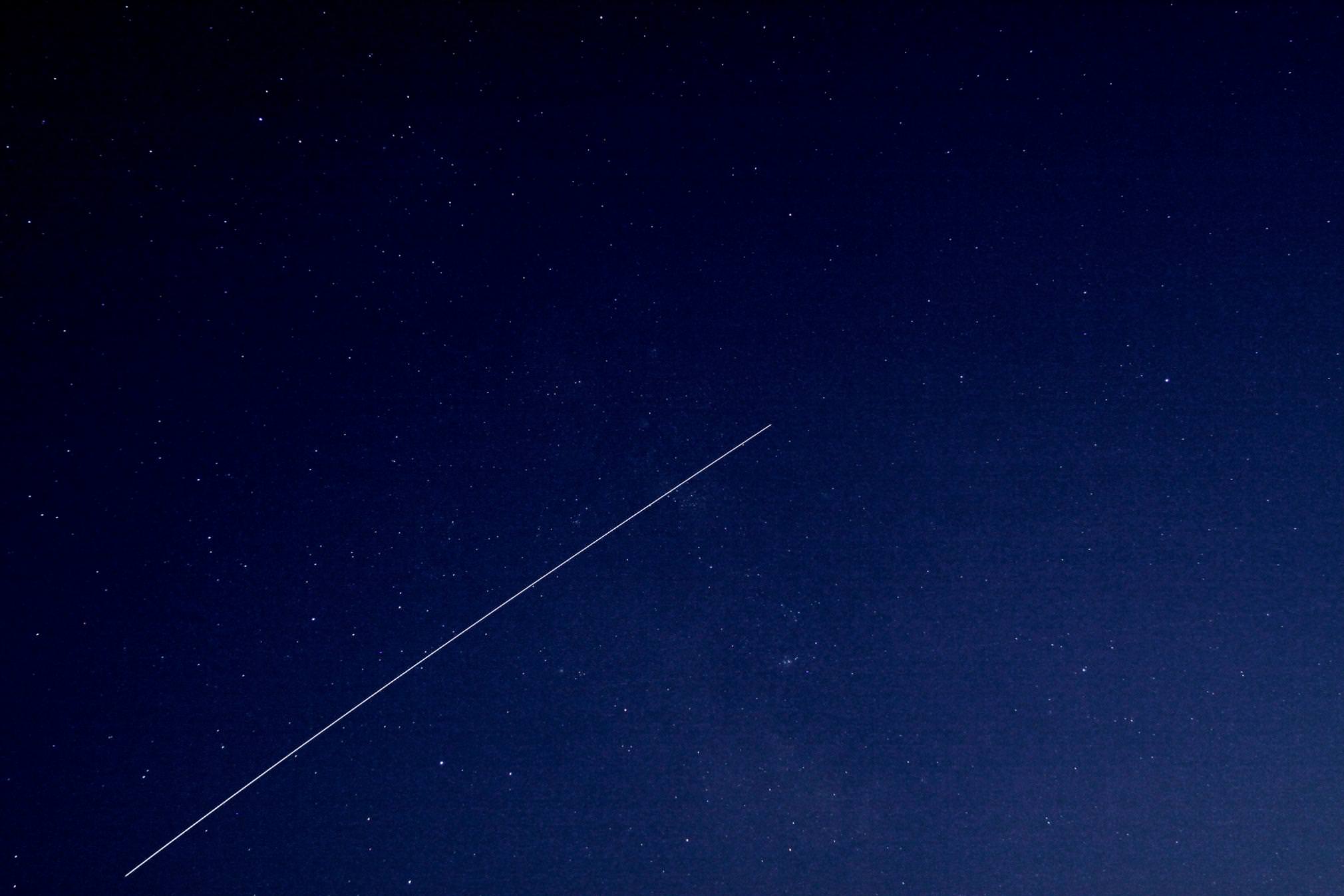
Not only is the center of our galaxy a busy place for seeing deep space objects – but near ones as well! In this photo taken by Mike Romine, you’ll see many Messier and NGC objects, but one feature really stands out – the ISS. Before you move on, stop and take a closer look. You’ll also find the signatures of an airplane and a tumbling satellite in the frame as well! (Hint: These show up as perfectly spaced series of dots.)
This image was taken on September 4 with a Canon EOS 50D, 135mm lens, F/5.6, ISO 1600, 90 seconds, mounted on a Celestron SCT on a CG5-GT mount at approximately 9:00 pm EST.
Want to get your astrophoto featured on Universe Today? Join our Flickr group, post in our Forum or send us your images by email (this means you’re giving us permission to post them). Please explain what’s in the picture, when you took it, the equipment you used, etc.
No Evacuation Plans for ISS Yet
[/caption]
The International Space Station has had a continual human presence for nearly 11 years, and so the astronauts now aboard the ISS are holding out hope that they won’t have to break that streak and turn out the lights and close all the hatches when they leave. Ron Garan and Mike Fossum said in a news conference with reporters on Tuesday that they have not yet been training for the possibility that they will have to leave the ISS unmanned due to a problem with the Soyuz rocket, the only ride astronauts and cosmonauts currently have to space.
“It’s too early for us to get too worried about that, frankly,” said Fossum, “and we haven’t started to do anything specific up here,except for documenting things we do on video. Fossum added that teams in mission control in Houston and Moscow are figuring out the procedures of what needs to be done if a problem with the Soyuz rockets can’t be figured out by November. “It will take us a few weeks to finish that up, but we have another nine or so weeks here, my crew of three. So we’ve got plenty of time for those kinds of things.”
Fossum said the ground crews are in the preliminary stages of deciding everything, “from what ventilation we’re going to leave running, what lights we’re going to leave on, what condition each particular experiment will be on, every tank, every valve, every hatch.”
A Russian rocket carrying a Progress resupply ship failed just after the third stage ignition two weeks ago and crashed into Siberia. While the Progress cargo ships launch on a Soyuz-U rocket and the Soyuz crew capsules — the Soyuz TMA — launches on a Soyuz-FG, the third stages of the two rockets are virtually identical.
Russian engineers said last week a malfunction in the third stage engine’s gas generator occurred; now they need to find out why and launch a couple of unmanned rockets before putting humans on board.
Right now a crew of six is on the station, with three of them scheduled to depart late next week – a week later than originally planned — to keep the station fully staffed as long as possible. A new crew of three was supposed arrive later this month, but that flight is on hold at least until early November, depending on the outcome of the investigation by the Russian engineers.
Since the space shuttles are no longer flying, the Soyuz is the only ride in town. While SpaceX is scheduled to send an unmanned Dragon capsule in a test run for bringing cargo to the station, the station would have to be abandoned if the Soyuz rocket isn’t cleared by November.
“It’s a complicated thing, when a rocket shuts down. It is a big deal,” said Fossum. “We’re not part of that investigation but we know what is going on. It’s not a fundamental design flaw, as this rocket has had hundreds of successful fights. But they are looking for what has changed.”
So, ground teams are now looking ahead for all the possible “what ifs” that might occur and Fossum and Garan said the big problem would be a short time span to do a crew handover – training in the new crew – or if they have to leave the station unmanned. They’ve started videotaping procedures and intricacies they’ve discovered about the station, just in case they aren’t there when a new crew arrives.
But it’s been a source of pride that there have been crews up here for over 4,000 days straight. “I think it is important,” said Fossum, “the station requires some care and feeding, and it is important for us to be here if we possibly can. If we have to shut it down for awhile, we will do our best to leave it in the best possible condition for the next crew to open the doors and turn the lights and and get back to work.”
The astronauts said if they do have to leave the station unmanned for a short period, it shouldn’t be a problem, but if the short gap turns into months, “the probability starts to stack up against you and leads to possibility that you would have a problem that could be significant without anyone up here to take action,” said Fossum.
Meanwhile, science operations are going full speed ahead. “We’re breaking records every week with crew-based research, over and above the autonomous research,” Garan said. “It’s important to note, that in the event we have to leave, there will still be science operations on board.”
ISS Crew Provides Light-Hearted Look at Current Space Flight Plight
What does the International Space Station crew think about the situation they face since the Progress cargo ship mishap? Astronaut Ron Garan wanted to do something light-hearted to let everyone know that “we are all in this together,” so he and his crewmates created a video. Garan said “Despite the seriousness of the possibilities, and while we are all in this period of uncertainty, it doesn’t mean we can’t still have a little fun.”
This video also provides an impromptu tour of the ISS and shows how big the space station is, as it takes fellow astronaut Mike Fossum a long time to find Garan.
It should be noted that they made this video before they got the news of the potential of having the ISS unmanned. “This would have serious implications, and we all hope that it does not come to that,” Garan wrote on his Fragil Oasis blog. You can read Garan’s entire commentary about the video at that link, and take a look around at his other postings, as well. Garan is doing a great job of sharing his experiences in space.
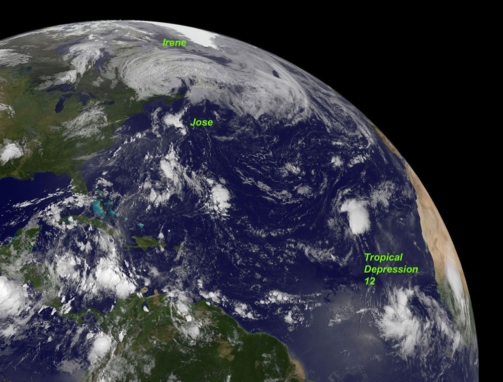
Deadly and Destructive Path of Hurricane Irene seen in NASA Videos and Images
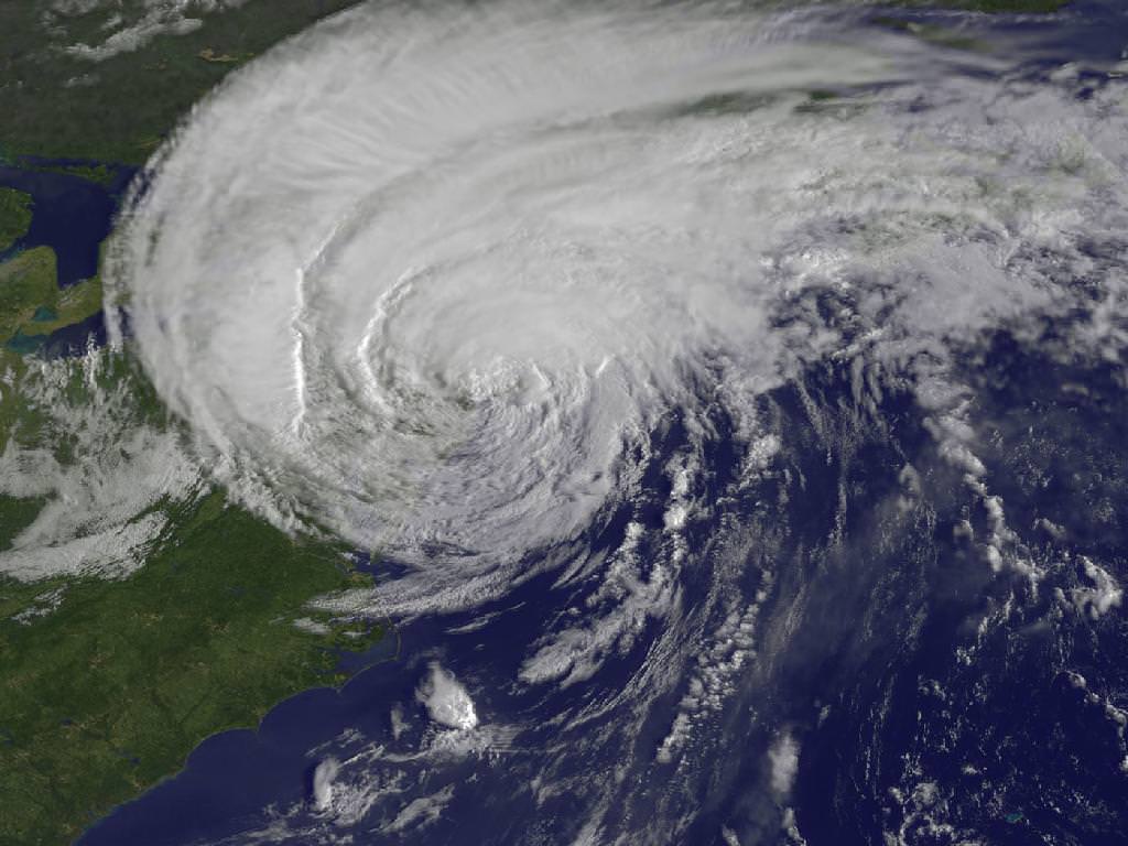
NASA Video Caption: The Life of Hurricane Irene from the Caribbean to Canada from August 21 through August 29 seen by NASA/NOAA satellites. Credit: NASA/NOAA/GOES/MODIS
The new NASA animation above shows the birth and subsequent destructive and deadly path followed by Hurricane Irene from August 21 through August 29, 2011 starting in the Caribbean, and then tracking along the US East Cost and up into Canada. The observations combine images taken by NASA and NOAA Earth orbiting satellites.
The cloud images were captured by the NASA/NOAA GOES-13 satellite and overlaid on a true-color NASA MODIS map. Irene followed a lengthy course over Puerto Rico, Hispaniola, the Bahamas, and then along the entire US East with landfalls over North Carolina, New Jersey and New York.
NASA ISS astronaut Ron Garan and cameras flying overhead aboard the International Space Station (ISS) also photographed vivid images showing the magnitude of Irene slamming into the US East coast.
Irene caused widespread property damage. Massive and raging flooding in several US states destroyed houses, crushed businesses and washed away bridges and roads and more. The worst flooding is yet to come to some inland portions of Vermont, New Jersey, New York, Pennsylvania and elsewhere as uncontrollable waters continue to rise at numerous rivers, lakes and even ponds, threatening even more misery in their wake.
[/caption]
So far 41 fatalities in 12 states have been attributed to Irene and more may be expected as searches continue. Some communities have been entirely cut off due to washed out access. Airlifts of food and water have begun. More people are being evacuated from New Jersey towns today, Aug 30.
Brave emergency rescue workers have put their own lives at peril and saved the lives of countless others of all ages from babies to the elderly. Some 8 million customers, including my area, lost power due to extensive flooding, downed trees and electrical wires, and devastated infrastructure.
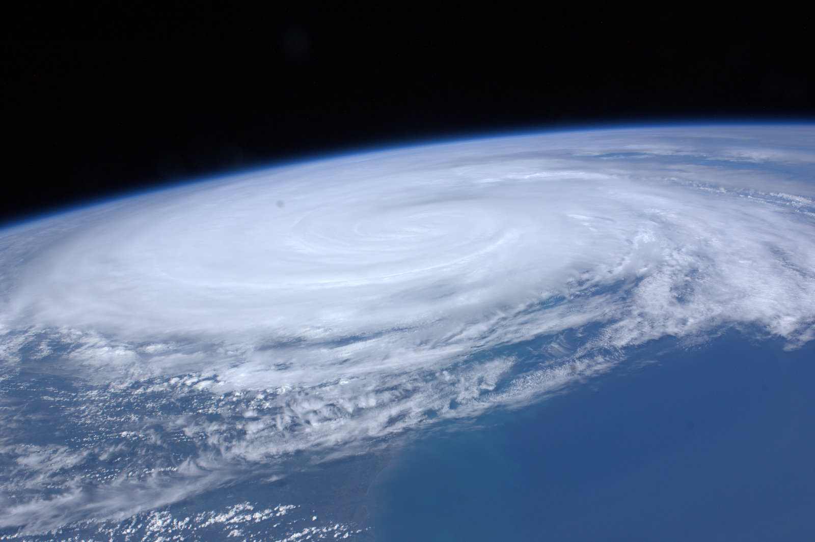
Irene From Space and the ISS as it crossed the coast on August 27, 2011 at 3:32pm EST. Hope everyone is OK wrote NASA Astronaut Ron Garan with his twitpic from the ISS. Credit: NASA/Ron Garan aboard the ISS
Emergency crews are hard at work to restore power as quickly as possible, but many thousands of homes and businesses could be without power for up to a week or more. About 3.3 million customers are still without power today.
NASA’s GOES-13 satellite captured a dramatic view of Hurricane Irene just 28 minutes prior to making landfall over New York City. Today’s NASA Image of the day shows the humongous cloud cover spanning the US East coast from the Mid-Atlantic States up to New Jersey, New York, Pennsylvania, and New England and into Toronto, Canada.
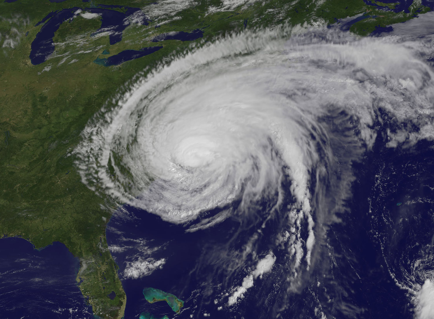
Many transit systems and airports in Irene’s path were shutdown ahead of the storm.
Send me your photos of Irene’s destruction to post at Universe Today.
Cause of Progress Crash May Have Been Determined
[/caption]
The Russian news agency Itar-Tass is reporting that the cause of the August 24 failure and crash of the Progress re-supply ship that was supposed to bring supplies to the International Space Station may have already been determined. “Members of the emergency commission have determined the cause of the failure of the Soyuz carrier rocket’s third stage engine,” Roscosmos spokesman Alexei Kuznetsov was quoted. “It is a malfunction in the engine’s gas generator.”
If the cause has indeed been found and if the anomaly can be resolved to the satisfaction of both Roscosmos and NASA, it might prevent a worst-case scenario of having to de-crew the International Space Station by mid-November, which NASA Space Station Program Manager Mike Suffredini said was a potential outcome.

The emergency commission to study the problem was only formed on August 26, and that a cause has already been found comes as a bit of a surprise. The commission is lead by Anatoly Koroteev, head of the Russian Keldysh science research institute on rockets.
“He is a man with quite a bit of experience in this field for our Russian colleagues, and indeed the world,” Suffredini said during a press briefing on Monday morning. But Suffredini also said that it would likely take the commission awhile to sort out the cause and its implications to future flights.
“The team is just getting going,” Suffredini commented. “They are trying to work quickly to resolve the anomaly but they don’t want to leave any stone unturned.”
What actions will be taken to resolve the problem now that a cause may be established are not yet known. Suffredini said that two Soyuz-family unmanned rockets are scheduled to launch soon, which may provide a chance to test any fixes on unmanned launches before attempting a manned launch. A commercial Soyuz to launch a mobile communications satellites is scheduled on Oct. 8, and the Russians may launch the Progress resupply ship that is currently scheduled for October 26 a few weeks earlier in order to have another unmanned launch to study the problem.
The Progress cargo ships launch on a Soyuz-U rocket, while the Soyuz crew capsules, the Soyuz TMA launches on a Soyuz-FG. The third stages of the two rockets are virtually identical. The Soyuz-U rocket has had 745 successful launches and just 21 failures over nearly four decades. The Soyuz-FG has had 25 launches, all successful.
Get your ISS Updates from Twitter

We mentioned this a couple of years ago, but I think it’s time for a reminder. There’s a great Twitter service called @twisst, which you can use to notify you when the International Space Station is going to be passing overhead in your region. It pulls your location from your profile, and then calculates good viewing times for you to see the station. All you have to do is follow the Twitter account.
Oh, and while you’re following Twitter accounts, don’t forget to follow the Universe Today Twitter feed.
P.S. Now I’m off to watch the station go overhead my house… thanks @twisst!
The View from Space: Northwestern Europe at Night

[/caption]
Astronauts always say the view of Earth is the best part of being in space. Here’s a beautiful shot of northwestern Europe at night. The landscape is dotted with clusters of lights from individual urban areas; visible are London, Paris, Brussels, Milan and Amsterdam, which stand out due to their large light “footprints,” while the English Channel is completely dark.
This photograph was taken by one of the Expedition 28 crewmembers on the International Space Station (ISS) and was taken with a short camera lens, providing the wide field of view. To give a sense of scale, the centers of the London and Paris metropolitan areas are approximately 340 kilometers (210 miles) from each other.
Source: NASA Earth Observatory website
Latest Satellite Images/Videos as Hurricane Irene Bears Down on US East Coast
What a view: Here’s a video of Hurricane Irene’s path, starting on August 24 up until 18:40 UTC on August 26, 2011, as seen by a GOES satellite. Even though Hurricane Irene is continuing to slowly weaken as it pushes closer to the Carolina coast, this massive storm could affect a huge area of the Eastern US seaboard, and tropical storm force winds and squalls are buffeting the coast. Irene will impact the entire Mid-Atlantic and Northeast Coast, including Washington, Philadelphia, New York City, Hartford, Ct. and Boston this weekend.
This hurricane spans nearly 1,000 kilometers (600 miles).
Below is a video taken from the International Space Station late yesterday afternoon. Includes astronaut commentary on the view of this “huge, scary storm” from 370 km (230 miles) up:
Or click on this link to see the latest video of Hurricane Irene from GOES and Goddard Space Flight Center
Cameras mounted on the International Space Station captured this video. Forecasters are predicting landfall on the outer banks of North Carolina Saturday before tracking up the mid-Atlantic states and a possible path over the metropolitan New York area and New England late this weekend.
[/caption]
Hot off the wires is this satellite image of Hurricane Irene taken less than an hour ago (as of this writing) by one of the GOES satellites for NOAA.
Here’s the latest from WeatherBug:

And here’s the latest from the Moderate Resolution Imaging Spectroradiometer (MODIS) on the Terra satellite on August 25:
 on the Terra satellite on August 25. Credit: NASA")
See more up-to-date satellite images from NOAA’s cadre of Earth-observing satellites at this link.
Sources: NASA Earth Observatory, WeatherBug, NOAA, Goddard Space Flight Center
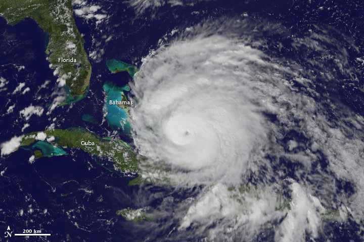
More Views of Hurricane Irene from Space: It’s Big

Here are several different views of Hurricane Irene: from 230 miles above the Earth, cameras on the International Space Station captured several views of powerful Hurricane Irene as it churned over the Bahamas at 3:10 p.m. EDT on August 24, 2011. Irene is moving to the northwest as a Category 3 hurricane, packing winds of 120 miles an hour. Irene is expected to strengthen to a Category 4 storm as it heads toward the Outer Banks of North Carolina, the Eastern Seaboard and the middle Atlantic and New England states.
See more from other satellites, below:
[/caption]
This view of Irene was taken by the GOES satellite at 2:55 p.m. Eastern Daylight Time on August 24, 2011. Irene now has a distinct eye and the clouds spiraling around the center are becoming more compact. The image also shows how large Irene has become, measuring several hundred kilometers across.

This image was taken on August 22, but is a really nifty, three-dimensional view of the precipitation from Irene, as seen by the Tropical Rainfall Measuring Mission. It reveals an area of deep convection (shown in red) near the storm’s center where precipitation-sized particles are being carried aloft. These tall towers are associated with strong thunderstorms responsible for the area of intense rain near the center of Irene seen in the previous image. They can be a precursor to strengthening as they indicate areas within a storm where vast amounts of heat are being released. This heating, known as latent heating, is what is drives a storm’s circulation and intensification.
Here’s the latest view of Irene from WeatherBug:

As of 8 a.m. EDT on August 25, Hurricane Irene was located near 25.5 N and 76.5 W, or 65 miles east-southeast of Nassau, Bahamas. This places it about 670 miles south of Cape Hatteras, N.C. Irene`s top sustained winds remain at 115 mph, and is moving to the northwest at 13 mph.
Sources: NASA Multimedia,