Dazzling Timelapse: Canary Skies

Tenerife, Canary Islands is home to several telescopes and at 2,000 meters above sea level, it claims one of the best skies on the planet. This incredibly stunning timelapse video from astrophotographer Daniel Lopez captures the nocturnal and crepuscular beauty of the island, showing the natural movement of the earth, stars, clouds, Sun and Moon. Lopez worked over a year to capture all possible shades and landscapes, pulling out all the stops by using several different timelapse techniques. Lopez promises more videos are coming, as he says this is the first in a series to capture the beauty of each of the Canary Islands.

Find more information at Lopez’s website, and see more videos at his Vimeo page.

Why Endeavour scrubbed on Friday

We were not in the Spacevidcast studios for this one, but I kept getting questions about the APU and why we scrubbed. Thought it wise to create a quick little SpacePod to explain why the final launch of Space Shuttle Endeavour was delayed to No Earlier Than Monday, May 2nd, 2011.

Spring Fireballs

For reasons yet unknown, the rate of midnight fireballs increases during the weeks around the vernal equinox. It’s a beautiful display, but where do they come from? Last month, we reported on a network of fireball cameras that NASA is building, which is now tracking incoming fireballs — and just in time, too, for the fireball season. This video is part of a new series by NASA called ScienceCast, which will be a weekly feature highlighting a topic in NASA science news.

Coalition for Space Exploration Tasks us to “Think Outside the Circle”

The aerospace industry is typically filled with engineers, scientists and pilots. Hardly the segment of the population that is subject to expounding on the virtues of their trade in prose or through some other format. That said, every once and a while, a campaign, image or video comes along that simply nails what the men and women of the industry have been trying to say. Continue reading “Coalition for Space Exploration Tasks us to “Think Outside the Circle””

What Did Gagarin See on His Historic Flight?

50 years ago, April 12th, Yuri Gagarin became the world’s first human to go into space. What did he see? He described it fairly well, but there are limited pictures and no video from his time in orbit. Now, through a unique collaboration between a filmmaker and ESA astronaut Paolo Nespoli on board the International Space Station, high definition video of what Gagarin might have seen has been woven together with historic recordings of the flight (subtitled in English) to create a new, free film that will be released on the 50th anniversary titled First Orbit. Above is the trailer for the film. What a perfect way to celebrate this historic moment.

“Circling the Earth in my orbital spaceship I marveled at the beauty of our planet. People of the world, let us safeguard and enhance this beauty — not destroy it!” — Yuri Gagarin.

Continue reading “What Did Gagarin See on His Historic Flight?”

Highlights of 2010 from the European Space Agency

It has been another great year in space, and the European Space Agency has put together a video highlight reel for 2010. They look at the achievements in different areas, including Earth Observation, Science, Human Spaceflight and Telecommunications. From the launch of Cryosat to the Planck sky scan, from Node 3 Cupola completing the ISS to Paolo Nespoli launching on the Soyuz to the ISS, from the Rosetta flyby of asteroid Lutetia to the launch of Hylas providing broadband for Europe.

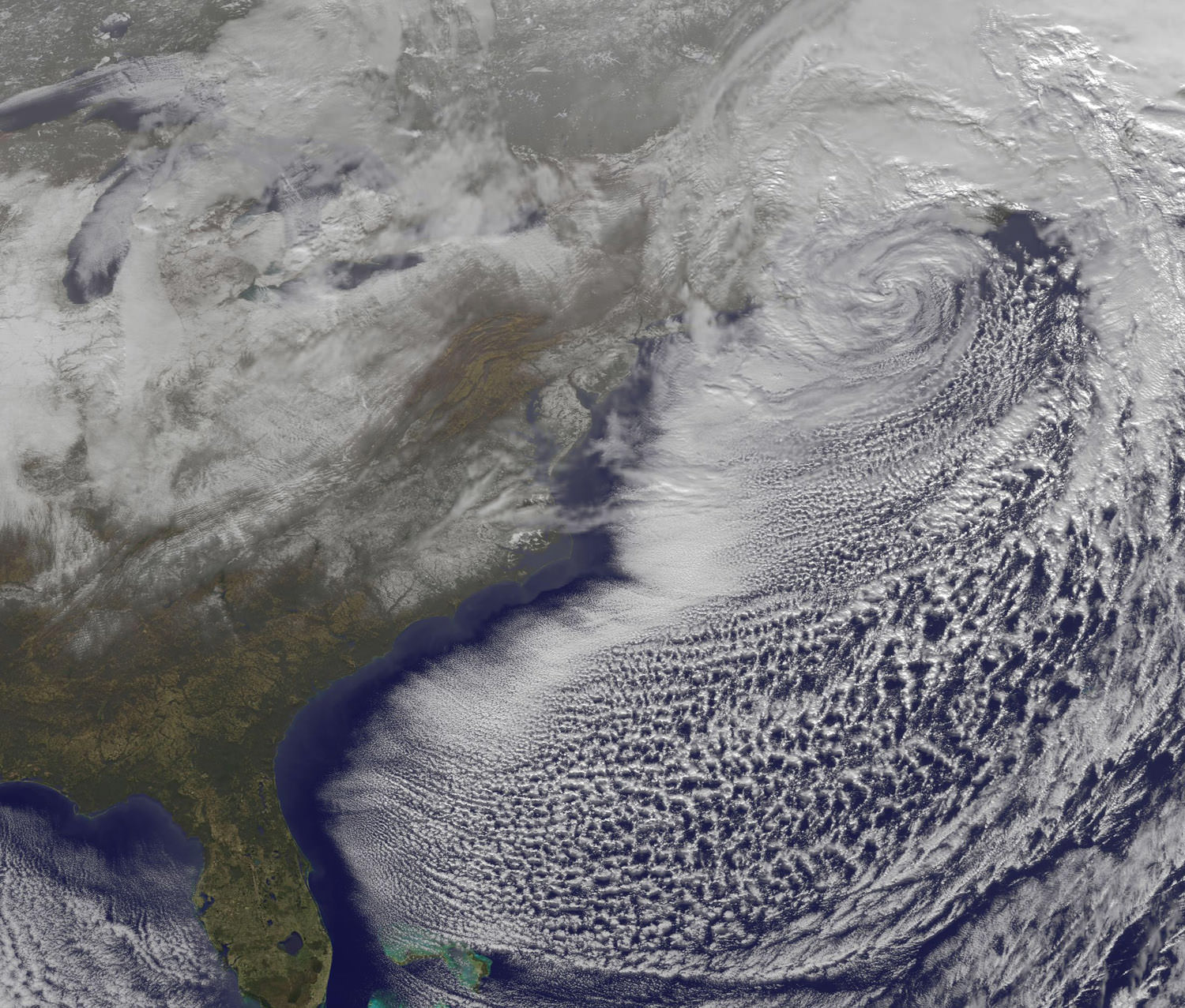
Video: Satellite Views of the “Christmas Blizzard”

On Monday, Dec. 27 at 1731 UTC (12:31 p.m. EST) the GOES-13 satellite captured this visible image of the powerful low pressure system that brought snows from Georgia to Maine along the US east coast. Some of the snowfall can be seen over South and North Carolina, Virginia, Maryland, Delaware, eastern Pennsylvania, New Jersey and southeastern New York. The clouds of the low obscure New England in the image. Credit: NOAA/NASA GOES Project

The Christmas Blizzard of 2010 dumped up to 30 inches of snow in the northeast United States, with winds gusts up to 60 mph. An Earth-orbiting satellite, GOES-13 captured a series of visible images of the storm, showing its progression. News reports from New York City say this is the sixth largest snowstorm in the city’s history and it buried the streets in four-foot drifts, bringing transit to a halt with cars and buses stranded in the streets.

Snowfall ranged from 1.5 inches in Atlanta, Georgia to more than two feet in various areas of New Jersey, New York and the New England states.

[/caption]

Some of those snows are visible in the above GOES-13 satellite image. Snowfall on the ground can be seen in the image over South and North Carolina, Virginia, Maryland, Delaware, eastern Pennsylvania, New Jersey, and southeastern New York. The clouds of the low obscure New England in the image.

Photographer Michael Black took an amazing timelapse of the blizzard, with a Canon DLSR on tripod with remote timer taking a photo once every five minutes (approximately 20 hours in 40 seconds.) — and obviously having to go outside and readjust the clock and markers.

December 2010 Blizzard Timelapse from Michael Black on Vimeo.