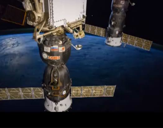
Screencap from a Vine video from Reid Wiseman on the International Space Station.
Oh, man you’re killin’ me Reid! Astronaut Reid Wiseman has been flooding the Twitter-waves with photos and news from the International Space Station, (you really need to check out his feed if you haven’t yet) and he’s also doing that crazy Vine video thing too. (In fact he did the first Vine from space earlier this month). This one is just awesomely beautiful.
The 2014 contest had two categories: “Beauty of The Night Sky” and “Against The Lights.”
“Both contest categories provide a visual awareness of the disappearing starry night sky and hopefully an understanding as to its cause,”said contest judge Connie Walker, associate scientist and education specialist at the National Optical Astronomy Observatory. “The added hope is that the photos will provide an incentive to be more actively involved in reasonable light pollution solutions and therefore dark skies preservation.”
Click on each of the image here for larger versions.
The first prize in Beauty of the Night Sky category was awarded to Luc Perrot from Réunion Island of France (southern Indian Ocean), for his image “Over the Top,” below, shot on Feb 28, 2014. A volcano in the Reunion Island peaks out of a sea of clouds and rests under stars.
“The photograph beautifully captures a scene that is eternal, the central bulge of the Milky Way is rising majestically over Piton de la Fournaise volcano,” said contest judge David Malin, who is widely known as a pioneer in scientific astrophotography “The image shows no sign of human presence, and is a reminder that the foreground landscape and the dark dust lanes in the Milky Way are made of the same elements, seen here as delicate clouds and solid mountain peaks.”
Here are the “Beauty of the Night Sky” top winners:
1- Luc Perrot, Reunion Island (France)
2- Ben Coffman, USA
3- Nicholas Roemmelt, Austria
4- Ibrahim Elawadi, Egypt
5- Phil Hart, Australia
We loved this image, below, from Nicholas Roemmelt of Austria for his outstanding capture of aurora over Kirkjufell waterfalls in Iceland in a moonlit night of March 2014, titled “Kirkjufell Nights” which won third place in the “Beauty of the Night” category.
Contest judge and long-time National Geographic photographer James Richardson regards this image “a fantastic confluence of the forces of nature. This is, of course, just one small corner of our universe, and yet we see swirling all the waterfalls carving at the rocky landscape, the mountain resisting erosion, the aurora sweeping around the pole and the stars beyond, part of the whole. The organizational power of this photograph is just wonderful.”
The first prize in “Against the Lights category” (and the overall contest winner) goes to Giorgia Hofer of Italy for his photo “Light in the Sky” taken on January 1, 2014 from Cibiana Pass in the Dolomites (Alps), northern Italy.
“I tried to portray the mist produced by the drones launched fireworks on the evening of new that were illuminated by a nearby light tower. in the only dark part of the sky the Big Dipper (the prominent part of constellation Ursa Major) is perfectly framed by the rays,” said the photographer.
Contest judge James Richardson said of this photo, “This captures the great ambiguity we feel about the night and night lighting. It is at once beautiful and beautifully composed. But it is also night lighting obscuring the beauties of the night. A beautiful image that confronts us with our own, conflicted desires.”
The entire “Against the Lights” winners are:
1- Giorgia Hofer, Italy
2- Alex Conu, Romania
3- Majid Ghohrudi, Iran
4- Mark Gee, New Zealand
5- Song Hongxiao, China
We also loved the fifth place winner in the “Against the Lights” category. “Heavenly Street” by Song Hongxiao of China is a long-exposure photo sequence of March 30, 2013 that captures star trails from the sacred Taishan or Mount Tai. Says the photographer: “Its been an ancient China tradition that people climb to the top of Mountain Tai to watch the beautiful sunrise and pray. In this picture thousands of people are walking across the Heavenly Street. The lights from their flashlight interplays with the stars in the sky.”
There are also 70 images as honorable mention which you can see in the video below, or in the contest Guest Gallery. The images were submitted (or taken) from 55 countries and territories.
A hot flow anomaly, or HFA, has been identified around Mercury (Credit: NASA/Duberstein)
Our Sun is constantly sending a hot stream of charged atomic particles out into space in all directions. Pouring out from holes in the Sun’s corona, this solar wind flows through the Solar System at speeds of over 400 km/s (that’s 893,000 mph). When it encounters magnetic fields, like those generated by planets, the flow of particles is deflected into a bow shock — but not necessarily in a uniform fashion. Turbulence can occur just like in air flows on Earth, and “space weather” results.
One of the more curious effects is a regional reversal of the flow of solar wind particles. Called a “hot flow anomaly,” or HFA, these energetic phenomena occur almost daily in Earth’s magnetic field, as well as on Jupiter and Saturn, and even on Mars and Venus where the magnetic fields are weak (but there are still planets blocking the stream of charged particles.)
Not to be left out in the cold, Mercury is now known to display HFAs, which have been detected for the first time by the MESSENGER spacecraft.
The first measurement was of magnetic fields that can be used to detect giant electric current sheets that lead to HFAs. The second was of the heating of the charged particles. The scientists then analyzed this information to quantify what kind of turbulence exists in the region, which provided the final smoking gun of an HFA.
“Planets have a bow shock the same way a supersonic jet does,” explains Vadim Uritsky at NASA’s Goddard Space Flight Center. “These hot flow anomalies are made of very hot solar wind deflected off the bow shock.”
Enhanced-color image of Mercury indicating the chemical and physical differences across its surface. Credit: NASA/Johns Hopkins University Applied Physics Laboratory/Carnegie Institution of Washington.
The solar wind is not 100% uniform; it has discontinuities within its own complex magnetic fields. When these shifting fields pile up against a planet’s bow shock they can create turbulence patterns that trap hot plasma, which in turn produces its own magnetic fields. The shockwaves, heat, and energy produced are powerful enough to actually reverse the flow of the solar wind within the HFA bulge.
And the word “hot” is putting it lightly — plasma temperatures in an HFA can reach 10 million degrees.
Mercury may be only a little larger than our Moon but it does possess an internally-generated dipolar magnetic field, unlike the Moon, Venus, and Mars which have only localized or shallow fields. The confirmed presence of HFAs on Mercury indicates that they may be a feature in all planetary bow shocks, regardless of how their magnetic fields — if any — are produced.
In related news, on June 17 MESSENGER successfully completed the first orbit adjustment maneuver to prepare it for its new — and final — low-altitude campaign, during which it will obtain its highest-resolution images ever of the planet’s surface and perform detailed investigations of its composition and magnetic field. Read more on the MESSENGER site here.
SpaceX founder and CEO Elon Musk briefs reporters including Universe Today in Cocoa Beach, FL prior to SpaceX Falcon 9 rocket blastoff with SES-8 communications satellite on Dec 3, 2013 from Cape Canaveral, FL. Credit: Ken Kremer/kenkremer.com
Elon Musk, CEO of SpaceX, is a hot topic in the media these days. He recently unveiled a manned version of his successful Dragon spacecraft. He’s talking about retrieving the first stage of his Falcon 9 rocket, a feat that has never been accomplished.
Last night (June 18), Musk spoke on CNBC because his company was named #1 to the cable network’s second annual Disrupter 50 list. You can watch portions of the interview here and we’ve isolated the space-related parts below based on the transcript from CNBC (which does not exactly match Musk’s words, but is pretty close.)
And Musk is still a big fan of Mars exploration, as he says in the interview he hopes to see people walk on the planet in 10-12 years.
On attempting to recover the first stage of the Falcon 9 rocket that will launch six Orbcomm satellites on Friday, if the weather holds (it is only 30% go according to local news reports):
Essentially what I was alluding to a moment ago was is to be able to recover the rocket booster and then refly it. That’s the revolutionary potential. Now we have been trying to do that for 12 years, and haven’t yet succeeded. But I feel as though we are finally close to achieving it. We have a shot with the next launch of recovering the rocket booster. If not with this launch, I think a very good chance later this year, and then potentially to refly the booster next year. This would really mark a significant change in the technology of rocketry.
‘Threading the needle’, the Falcon 9/Dragon vehicle passes through the catenary lightning wires as it roars from the pad on the CRS-3 mission. Credit: nasatech.net
Musck also spoke on what would happen if SpaceX does not get the next round of commercial crew funding from NASA. The company is right now being funded along with Boeing (CST-100) and Sierra Nevada (Dream Chaser), but NASA is still figuring out how many companies it can afford to back in the next stage, which will be announced later this year. Musk revealed the manned prototype version of its Dragon spacecraft to great media fanfare in late May.
First of all, I should acknowledge the critical role NASA played in the success of SpaceX. We wouldn’t be are where we are without the help of NASA. And it’s possible we may not win the commercial crew contract. We certainly have done that we can for our part. And I think we have got a great design solution. If NASA in the end doesn’t go with us, because also we are competing with big established companies like Boeing, then we’ll do our best to continue on our own with our own money. […]
Well it definitely would slow us down, but we would keep going and we should keep launching commercial satellites. We have an existing contract to transfer…from the space station so we would keep going. It just would be slower.
Elon Musk seated inside Dragon V2 explaining consoles at unveiling on May 29, 2014. Credit: SpaceX
Musk on how quickly he wants to see humans on Mars:
This is a very difficult thing, obviously. I’m hopeful that the first people could be taken to Mars in 10, 12 years. I think it’s certainly possible for that to occur. The thing that matters long term is to have a self-sustaining city on Mars. To make life multi-planetary. That will define a fundamental bifurcation of the future of human civilization. We’ll either be a multi-planet species and out there among the stars, or a single-planet species until some eventual extinction event, natural or man-made.
Why it’s difficult to get public funding right now:
The incentive structure tends to be short-term. You can trace it back to people that own the stocks, portfolio managers. They are evaluated on a quarterly basis, or at least an annual basis. They push companies to produce results on a quarterly or annual basis. With SpaceX we are trying to develop technology that will ultimately be able to take large numbers of people to Mars. That’s really difficult to get portfolio managers. It’s beyond their tenure in owning the stock. So it is difficult to ask them to like that.
The SpaceX Dragon capsule on approach to the ISS during the COTS 2 mission. Credit: NASA.
Which is harder, getting people to Mars or building a car battery that costs less than $5,000 (which is an oblique reference to Musk’s Tesla line of vehicles):
I think, probably, Mars. The car battery certainly is hard. I’m quite optimistic, though, about improvements in the battery price or the cost of the battery. The fundamental cost. We have daily meetings with Panasonic, our key development partner, on this. I am really feeling quite good about being able to produce a compelling mass market car in about three years.
What would be a “truly disruptive” technology:
I mean, at this point, human life span is mostly about old age. It’s not about cancer or anything else. If you cured cancer, I think the average life expectancy would increase from two years. You would go from 80 to 82, or something like that. We just have a genetic life span. It’s kind of like if you take a fruit fly and gave it the best exercise and diet possible, the perfect life. Maybe it will live four weeks instead of three weeks. Genetics just drives a lot of these things. So for something to be truly disruptive on that front, you would want to do something with genetics. I don’t have much involvement there. Or any involvement, really.
Artist's conception of the E-ELT (left) and Very Large Telescope compared with the Giza Pyramids. Credit: ESO
While we space geeks are lucky enough to watch rocket launches regularly, it’s not often we get to see a mountain top being blown off for the sake of astronomy!
Tomorrow, the European Southern Observatory plans an event centered on a blast on Cerro Armazones, a 3,060-meter (10,000-foot) mountain in Chile’s Atacama Desert. The goal is to make way for construction of the European Extremely Large Telescope, which as its name implies will be a monster of an observatory. Read below for details on how to watch live.
“The E-ELT will tackle the biggest scientific challenges of our time, and aim for a number of notable firsts, including tracking down Earth-like planets around other stars in the ‘habitable zones’ where life could exist — one of the Holy Grails of modern observational astronomy,” ESO states on its page about the 39-meter (128-foot) optical/near-infrared telescope.
The set-up crew for the E-ELT blast looks at Cerro Armazones. Credit: ESO
“It will also perform ‘stellar archaeology’ in nearby galaxies, as well as make fundamental contributions to cosmology by measuring the properties of the first stars and galaxies and probing the nature of dark matter and dark energy.”
We’re sure astronomers can hardly wait for operations to start in the next decade or so. ESO will livetweet the event (also follow the hashtag #EELTblast, where you can ask questions) and watch the entire event live tomorrow here, starting around 12:30 p.m. EDT (4:30 p.m. UTC).
In related news, the last of the Atacama Large Millimeter/submillimeter Array’s (ALMA’s) 66 antennas recently arrived at the ALMA site, which is 5,000 meters (16,400 feet) high on the Chajnantor Plateau in the Atacama Desert of northern Chile. This ESO telescope was officially inaugurated last year.
View of the Atacama Large Millimeter/submillimeter Array (ALMA) site, which is 5,000 meters (16,400 feet) on the Chajnantor Plateau in the Atacama Desert of northern Chile. Credit: A. Marinkovic/X-Cam/ALMA (ESO/NAOJ/NRAO)
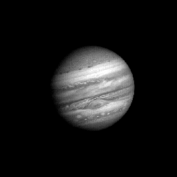
This animated gif shows Voyager 1's approach to Jupiter during a period of over 60 Jupiter days in 1979. Credit: NASA.
Back in the 1970’s when NASA launched the two Voyager spacecraft to Jupiter, Saturn, Uranus, and Neptune, I remember being mesmerized by a movie created from Voyager 1 images of the movement of the clouds in Jupiter’s atmosphere. Voyager 1 began taking pictures of Jupiter as it approached the planet in January 1979 and completed its Jupiter encounter in early April. During that time it took almost 19,000 pictures and many other scientific measurements to create the short movie, which you can see below, showing the intricate movement of the bright band of clouds for the first time.
Now, 35 years later a group of seven Swedish amateur astronomers achieved their goal of replicating the Voyager 1 footage, not with another flyby but with images taken with their own ground-based telescopes.
“We started this joint project back in December of 2013 to redo the NASA Voyager 1 flyby of Jupiter,” amatuer astronomer Göran Strand told Universe Today. “During 90 days we captured 560 still images of Jupiter and turned them into 90 complete maps that covered the whole of Jupiter’s surface.”
Their newly released film, above details the work they did and the hurdles they overcame (including incredibly bad weather in Sweden this winter) to make their dream a reality. They called their project “Voyager 3.”
Animated gif of the ‘Voyager 3’ team re-enactment of the Voyager 1 flyby. Credit: Voyager 3 team, via Kristoffer Åberg.It is really an astonishing project and those of you who do image processing will appreciate the info in the video about the tools they used and how they did their processing to create this video.
The seven Swedish astronomers who participated in the Voyager 3 project are (from left to right in the photo below) Daniel Sundström, Torbjörn Holmqvist, Peter Rosén (the project initiator), Göran Strand, Johan Warell and his daughter Noomi, Martin Högberg and Roger Utas.
The Swedish team of amateur astronomers who compiled the ‘Voyager 3’ project. Image courtesy Peter Rosén.
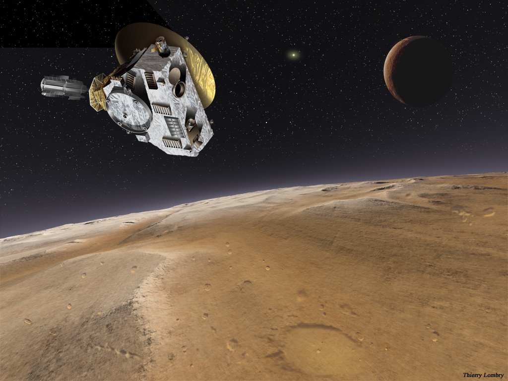
Artist's impression of New Horizons' encounter with Pluto and Charon. Credit: NASA/Thierry Lombry
It’s going to be a really busy summer for the New Horizons team. While they’re checking out the newly awakened spacecraft to make sure it’s working properly for its close encounter with Pluto next year, NASA is already thinking about where to put it next: possibly towards a Kuiper Belt Object!
So now the Hubble Space Telescope (in Earth orbit) is scoping out icy objects beyond Pluto. Luckily for us, one of the team members — Alex Parker, a planetary astronomer at the University of California, Berkeley, provided an entertaining livetweet of the process — even through a power failure.
So, the secret is out. On Friday, we were awarded the Hubble time to search for a @NewHorizons2015 KBO target!
There’s far more to Parker’s tweets than we are indicating here; his Twitter feed also has details about the collaborators, for example, so be sure to read through the entire exchange from yesterday. The survey is led by the Southwest Research Institute’s John Spencer.
What astronomers are doing now is a “pilot observation” where the space telescope looks at a spot in the constellation Sagittarius. Controllers will try to turn the telescope at the same rate as what a KBO would be orbiting around the sun. If the method works, stars will look like streaks and the KBOs will look like “pinpoint objects”, NASA stated.
A view of the Hubble Space Telescope from inside space shuttle Atlantis on mission STS-125 in 2009. Credit: NASA
“If the test observation identifies at least two KBOs of a specified brightness it will demonstrate statistically that Hubble has a chance of finding an appropriate KBO for New Horizons to visit. At that point, an additional allotment of observing time will continue the search across a field of view roughly the angular size of the full moon,” NASA said in a press release.
The reason for this step is Hubble is a high-profile telescope, receiving a lot of requests for observing time around the world. The agency wants to ensure that the telescope is being used for the best scientific return possible. NASA also noted the search might be difficult.
“Though Hubble is powerful enough to see galaxies near the horizon of the universe, finding a KBO is a challenging needle-in-haystack search. A typical KBO along the New Horizons trajectory may be no larger than Manhattan Island and as black as charcoal,” NASA stated.
This isn’t the first time the telescope has done a pinch-hit for Plutonian science. Four new moons have been found around Pluto, a discovery that involved Hubble time. The telescope has also looked for dust rings near the dwarf planet (to do a risk analysis for New Horizons’ approach) and done a map of the surface, to help controllers figure out where to target New Horizons.
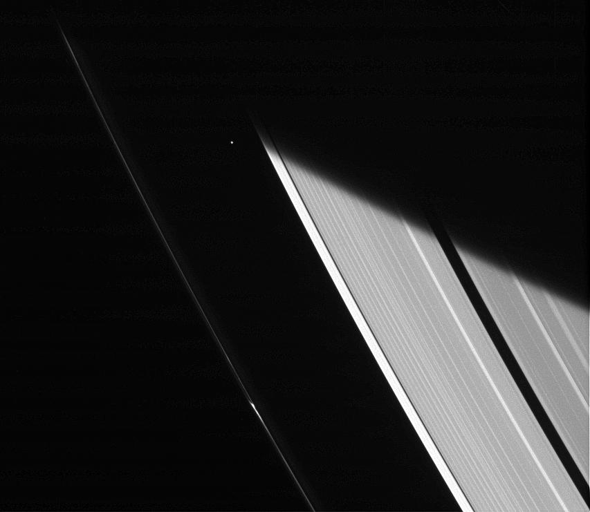
Saturn's moon Atlas peeks out between the rings in this Cassini shot taken Jan. 23, 2014. Credit: NASA/JPL-Caltech/Space Science Institute
See that small pixel? That’s an entire moon you’re looking at! Peeking between the rings of Saturn is the tiny saucer-shaped moon Atlas, as viewed from the Cassini spacecraft. The image is pretty, but there’s also a scientific reason to watch the planet’s many moons while moving around the rings.
“Although the sunlight at Saturn’s distance is feeble compared to that at the Earth, objects cut off from the Sun within Saturn’s shadow cool off considerably,” NASA stated.
“Scientists study how the moons around Saturn cool and warm as they enter and leave Saturn’s shadow to better understand the physical properties of Saturn’s moons.”
And if you look at Atlas close-up, it looks a little like a flying saucer! The moon is only 20 miles (32 km) across, which is a bit shy of the length of a marathon. The Voyager 1 team spotted the moon in 1980 when the spacecraft zoomed through the system. You can learn more about Saturn’s moons here.
Cassini is still in excellent health (it arrived at Saturn in 2004, and has been in space since 1997), and scientists are eagerly getting ready for when Saturn gets to its summer solstice in 2017. Among the things being looked at is a hurricane at Saturn’s north pole.
Saturn’s moon Atlas. Left image: viewed from the side, at a scale of 0.6 miles (1 km) per pixel. Right image: the mid-southern latitudes, at 820 feet (250 m) per pixel. The images are composite views from the Cassini spacecraft. Credit: NASA/JPL/SSI
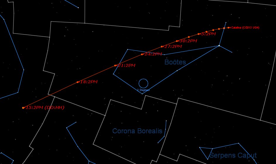
Though ISON may have fizzled in early 2014, we’ve certainly had a bevy of binocular comets to track this year. Thus far in 2014, we’ve had comets R1 Lovejoy, K1 PanSTARRS, and E2 Jacques reach binocular visibility. Now, and asteroid-turned-comet is set to put on a fine show this summer for northern hemisphere observers.
Veteran stargazer and Universe Today contributor Bob King told the tale last month of how the asteroid formerly known as 2013 UQ4 became comet 2013 UQ4 Catalina. Discovered last year on October 23rd 2013 during the routine Catalina Sky Survey searching for Near Earth Objects based outside of Tucson Arizona, this object was of little interest until early this year.
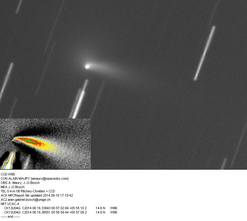
A recent image of 2013 UQ4 Catalina from June 16th. The development of fine tail structure can be seen. Credit: A. Maury & J.G. Bosch.
As it rounded the Sun, astronomers recovered the asteroid and discovered that it had begun to sprout a fuzzy coma, a very un-asteroid-like thing to do. Then, on May 7th, Taras Prystavski and Artyom Novichonok — of Comet ISON fame — conducted observations of 2013 UQ4 and concluded that it was indeed an active comet.
The orbital path of UQ4 Catalina in early July. Created using the JPL Solar System Dynamics Small Body Database Browser.
Hovering around +13th magnitude last month, newly rechristened 2013 UQ4 Catalina was a southern hemisphere object visible only from larger backyard telescopes. That should change, however, in the coming weeks if activity from this comet holds up.
The light curve of UQ4 Catalina with current observations (dots) noted. Credit: Seiichi Yoshida/Aerith.net.
2013 UQ4 belongs to a class of objects known as damocloids. These asteroids are named after the prototype for the class 5335 Damocles and are characterized as long-period bodies in retrograde and highly eccentric orbits. These are thought to be inactive varieties of comet nuclei, and other asteroids in the damocloid series such as C/2001 OG 108 (LONEOS) and C/2002 VQ94 (LINEAR) also turned out to be comets. Damocloids also exhibit the same orbital characteristics of that most famous inner solar system visitor of them all; Halley’s Comet.
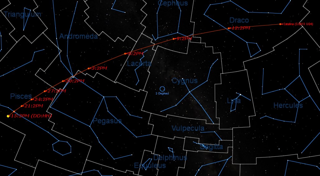
The path of Comet UQ4 Catalina looking towards the NE at 9PM local in early July from latitude 30 degrees north. Credit: Stellarium.
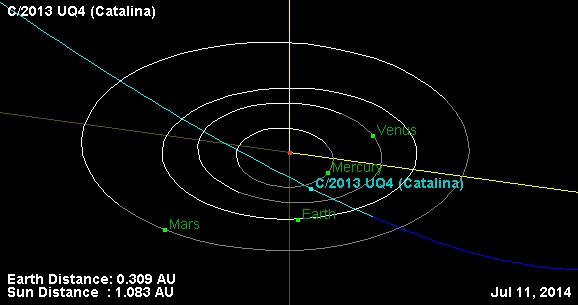
The good news is, 2013 UQ4 Catalina is brightening on schedule and should be a binocular object greater than +10th magnitude by the end of June. Recent observations, including those made by Alan Hale (of comet Hale-Bopp fame) place the comet at magnitude +11.9 with a bullet. The comet is currently placed high in the east in the constellation Pisces at dawn, and will soon speed northward and vault across the sky as it crosses the ecliptic plane this week. In fact, comet 2013 UQ4 Catalina reaches perihelion on July 6th only four days before its closest approach to the Earth at 47 million kilometres distant, when it may well reach a peak magnitude of +7. At that point, the comet will have an apparent motion of about 7 degrees a day — that’s the span of a Full Moon once every 1 hour and 42 minutes — as it rises in the constellation Cepheus to the northeast at dusk in early July. A fine placement, indeed. And speaking of the Moon, our natural satellite reaches New phase later this month on June 27th, another good reason to begin searching for 2013 UQ4 Catalina now.
Here’s a list of notable events to watch out for and aid you in your quest as comet 2013 UQ4 Catalina crosses the summer sky:
June 16th: The comet crosses north of the ecliptic plane.
June 20th: The waning crescent Moon passes 3 degrees from the comet.
The celestial path of the comet from June 16th to July 15th… Credit: Starry Night Education software.
June 29th: Crosses into the constellation of Andromeda.
July 1st: Passes less than one degree from the +2nd magnitude star Alpheratz.
July 2nd: Crosses briefly into the constellation Pegasus before passing back into Andromeda.
July 6th: The comet reaches perihelion or its closest point to the Sun at 1.081 A.U.s distant.
July 7th: Crosses into the constellation of Lacerta and passes the deep sky objects NGCs 7296, 7245, 7226.
July 8th: Crosses into the constellation Cepheus and across the galactic plane.
July 9th: Passes a degree from the Elephant Trunk open star cluster.
July 10th: Passes less than one degree from the stars Eta (magnitude +3.4) and Theta (magnitude +4.2) Cephei.
July 10th: Passes 2 degrees from the +7.8 magnitude Open Cluster NGC 6939.
July 10th: Passes closest to Earth at 0.309 A.U.s or 47 million kilometres distant.
July 11th: Crosses into the constellation Draco.
July 11th: Reaches its most northerly declination of 64 degrees.
July 12th: Photo op: the comet passes 3 degrees from the Cat’s Eye Nebula.
… and the path of the comet from July 15th to August 20th. Credit: Starry Night.
July 17th: The comet passes into the astronomical constellation of Boötes.
July 31st: Passes just 2 degrees from globular cluster NGC5466 (+9th magnitude) and 6 degrees from the famous globular cluster Messier 3.
From there on out, the comet drops below naked eye visibility and heads back out in its 470 year orbit around the Sun. Be sure to check out comet 2013 UQ4 Catalina this summer… what will the Earth be like next time it passes by in 2484 A.D.?
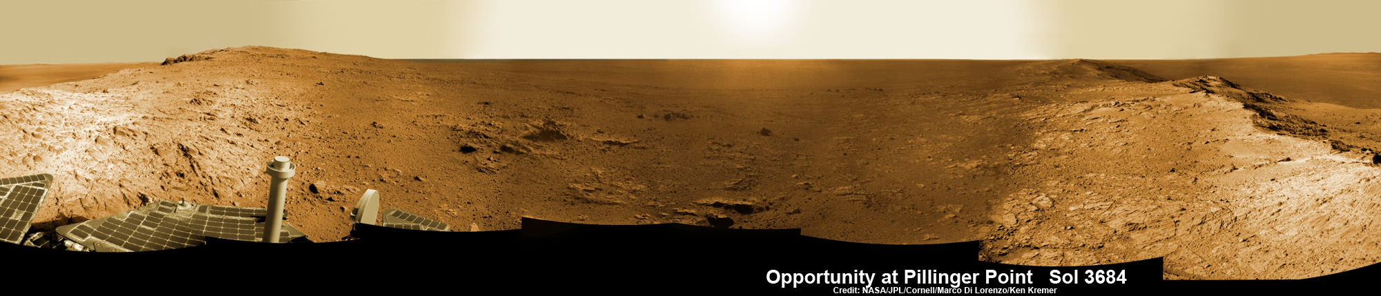
Opportunity Mars rover peers into vast Endeavour Crater from Pillinger Point mountain ridge named in honor of Colin Pillinger, the Principal Investigator for the British Beagle 2 lander built to search for life on Mars. Pillinger passed away from a brain hemorrhage on May 7, 2014. This navcam camera photo mosaic was assembled from images taken on June 5, 2014 (Sol 3684) and colorized. Credit: NASA/JPL/Cornell/Marco Di Lorenzo/Ken Kremer-kenkremer.com
NASA’s decade old Opportunity rover has reached a long sought after region of aluminum-rich clay mineral outcrops at a new Endeavour crater ridge now “named ‘Pillinger Point’ after Colin Pillinger the Principal Investigator for the [British] Beagle 2 Mars lander”, Prof. Ray Arvidson, Deputy Principal Investigator for the rover, told Universe Today exclusively. See above the spectacular panoramic view from ‘Pillinger Point’ – where ancient water once flowed billions of year ago.
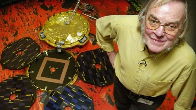
The Beagle 2 lander was built to search for signs of life on Mars.
The Mars Exploration Rover (MER) team named the noteworthy ridge in honor of Prof. Colin Pillinger – a British planetary scientist at the Open University in Milton Keynes, who passed away at the age of 70 on May 7, 2014.
‘Pillinger Point’ is a scientifically bountiful place possessing both clay mineral outcrops and mineral veins where “waters came up through the cracks”, Arvidson explained to me.
Since water is a prerequisite for life as we know it, this is a truly fitting tribute to name Opportunity’s current exploration site ‘Pillinger Point’ after Prof. Pillinger.
See our new photo mosaic above captured by Opportunity peering out from ‘Pillinger Point’ ridge on June 5, 2014 (Sol 3684) and showing a panoramic view around the eroded mountain ridge and into vast Endeavour crater.
The gigantic crater spans 14 miles (22 kilometers) in diameter.
See below our Opportunity 10 Year traverse map showing the location of Pillinger Point along the segmented rim of Endeavour crater.
British planetary scientist Colin Pillinger with the Beagle 2 lander.
Pillinger Point is situated south of Solander Point and Murray Ridge along the western rim of Endeavour in a region with caches of clay minerals indicative of an ancient Martian habitable zone.
For the past several months, the six wheeled robot has been trekking southwards from Solander towards the exposures of aluminum-rich clays – now named Pillinger Point- detected from orbit by the CRISM spectrometer aboard NASA’s powerful Martian ‘Spysat’ – the Mars Reconnaissance Orbiter (MRO) – while gathering context data at rock outcrops along the winding way.
“We are about 3/5 of the way along the outcrops that show an Al-OH [aluminum-hydroxl] montmorillonite [clay mineral] signature at 2.2 micrometers from CRISM along track oversampled data,” Arvidson told me.
“We have another ~160 meters to go before reaching a break in the outcrops and a broad valley.”
The rover mission scientists ultimate goal is travel even further south to ‘Cape Tribulation’ which holds a motherlode of the ‘phyllosilicate’ clay minerals based on extensive CRISM measurements accomplished earlier at Arvidson’s direction.
“The idea is to characterize the outcrops as we go and then once we reach the valley travel quickly to Cape Tribulation and the smectite valley, which is still ~2 km to the south of the present rover location,” Arvidson explained.
Mars Express and Beagle 2 were launched in 2003, the same year as NASA’s twin rovers Spirit and Opportunity, on their interplanetary voyages to help unlock the mysteries of Mars potential for supporting microbial life forms.
Pillinger was the driving force behind the British built Beagle 2 lander which flew to the Red Planet piggybacked on ESA’s Mars Express orbiter. Unfortunately Beagle 2 vanished without a trace after being deployed from the orbiter on Dec. 19, 2003 with an expected air bag assisted landing on Christmas Day, Dec. 25, 2003.
In an obituary by the BBC, Dr David Parker, the chief executive of the UK Space Agency, said that Prof. Pillinger had played a critical role in raising the profile of the British space programme and had inspired “young people to dream big dreams”.
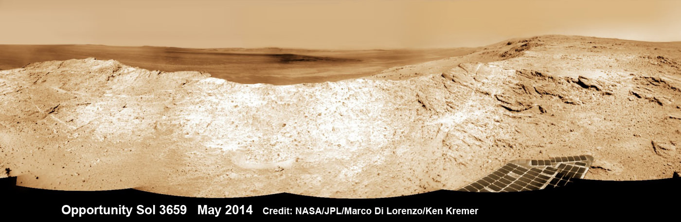
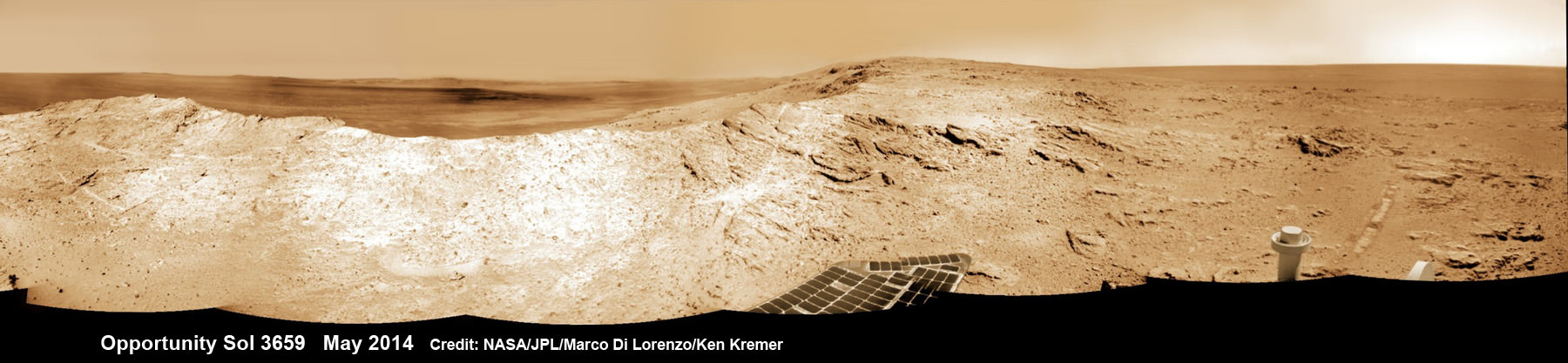
NASA’s Opportunity Mars rover captures sweeping panoramic vista near the ridgeline of 22 km (14 mi) wide Endeavour Crater’s western rim. The center is southeastward and also clearly shows the distant rim. See the complete panorama below. This navcam panorama was stitched from images taken on May 10, 2014 (Sol 3659) and colorized. Credit: NASA/JPL/Cornell/Marco Di Lorenzo/Ken Kremer-kenkremer.com
During his distinguished career Pillinger also analyzed lunar rock samples from NASA’s Apollo moon landing missions and worked on ESA’s Rosetta mission.
“It’s important to note that Colin’s contribution to planetary science goes back to working on Moon samples from Apollo, as well as his work on meteorites,” Dr Parker told the BBC.
Today, June 16, marks Opportunity’s 3696th Sol or Martian Day roving Mars – compared to a warranty of just 90 Sols.
So far she has snapped over 193,400 amazing images on the first overland expedition across the Red Planet.
Her total odometry stands at over 24.51 miles (39.44 kilometers) since touchdown on Jan. 24, 2004 at Meridiani Planum.
NASA’s Opportunity Mars rover captures sweeping panoramic vista near the ridgeline of 22 km (14 mi) wide Endeavour Crater’s western rim. The center is southeastward and the distant rim is visible in the center. An outcrop area targeted for the rover to study is at right of ridge. This navcam panorama was stitched from images taken on May 10, 2014 (Sol 3659) and colorized. Credit: NASA/JPL/Cornell/Marco Di Lorenzo/Ken Kremer-kenkremer.com
Meanwhile on the opposite side of Mars, Opportunity’s younger sister rover Curiosity is trekking towards gigantic Mount Sharp after drilling into her 3rd Red Planet rock at Kimberley.
Stay tuned here for Ken’s continuing Curiosity, Opportunity, Orion, SpaceX, Boeing, Orbital Sciences, MAVEN, MOM, Mars and more planetary and human spaceflight news.
Traverse Map for NASA’s Opportunity rover from 2004 to 2014 – A Decade on Mars
This map shows the entire path the rover has driven during a decade on Mars and over 3692 Sols, or Martian days, since landing inside Eagle Crater on Jan 24, 2004 to current location along Pillinger Point ridge south of Solander Point summit at the western rim of Endeavour Crater and heading to clay minerals at Cape Tribulation. Opportunity discovered clay minerals at Esperance – indicative of a habitable zone. Credit: NASA/JPL/Cornell/ASU/Marco Di Lorenzo/Ken Kremer