Hosts: Fraser Cain and Scott Lewis Astronomers: David Dickinson, Gary Gonella, Roy Salisbury, Sharin Ahmed, Stuart Forman, Mike Simmons
and some gorgeous pics from Cory Schmitz in the Southern Hemisphere
Scott also shares pics from the viewers
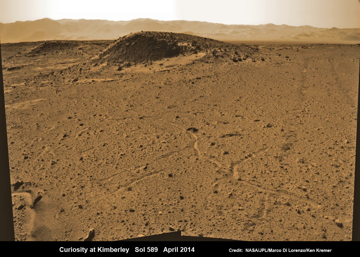
Curiosity maneuvers into ‘Kimbeley’ and scans scientifically intriguing Martian rock outcrops in search of next drilling location exhibiting several shallow hills in foreground and dramatic Gale crater rim backdrop. Rover tracks at right in this colorized Navcam photomosaic assembled from raw images snapped on Sol 589, April 3, 2014. Credit: NASA/JPL/Marco Di Lorenzo /Ken Kremer - kenkremer.com
Curiosity maneuvers into ‘Kimbeley’ and scans scientifically intriguing Martian rock outcrops in search of next drilling location exhibiting several shallow hills in foreground and dramatic Gale crater rim backdrop. Rover tracks at right in this colorized Navcam photomosaic assembled from raw images snapped on Sol 589, April 3, 2014.
Credit: NASA/JPL/Marco Di Lorenzo /Ken Kremer – kenkremer.com[/caption]
NASA’s car sized Curiosity rover has arrived at a scientifically enticing science destination at “The Kimberley Waypoint” where researchers hope to carry out the next drilling operation into alien Martian terrain in search of further clues about ancient Red Planet environments that may have been favorable for life.
“We are officially in ‘The Kimberley’ now,” Curiosity Principal Investigator John Grotzinger, of the California Institute of Technology, Pasadena, told Universe Today.
Since arriving in the Kimberley region, Curiosity’s earth-bound handlers have been maneuvering the 1 ton robot to thoroughly survey the destination dubbed “The Kimberley”.
Why was Kimberley chosen as a science destination?
“The Kimberley” has interesting, complex stratigraphy,” Grotzinger told me.
The team moved the six wheeled robot further this week in search of a suitable location to conduct the next drilling operation. The terrain is replete with diverse rock types and extensive outcrops.
I asked Grotzinger if today’s (April 5) location at ‘The Kimberley’ is the intended drill site?
“It’s a possible drill site,” Grotzinger replied.
“Pending further evaluation,” he noted.
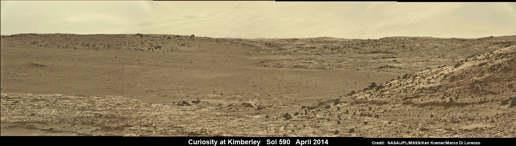
Curiosity scans scientifically intriguing rock outcrops of Martian terrain at ‘The Kimberley’ waypoint in search of next drilling location, beside low hill at right. Mastcam color photomosaic assembled from raw images snapped on Sol 590, April 4, 2014. Credit: NASA/JPL/MSSS/Ken Kremer – kenkremer.com/Marco Di Lorenzo
Curiosity drove the final stretch of some 98 feet (30 meters) on Wednesday, April 2, required to arrive at a major stopping waypoint planned since early 2013 for up close study of the Red Planet’s rocks.
Along the recent dune filled path to ‘The Kimberley’, Curiosity snapped breathtaking landscapes around the irresistible ‘Junda’ outcrop, much like a tourist.
See our photomosaics showing the spectacularly inviting terrain around Kimberly and Junda, above and below, by Marco Di Lorenzo and Ken Kremer.
Martian landscape with rows of curved rock outcrops at ‘Kimberly’ in the foreground and spectacular Mount Sharp on the horizon. NASA’s Curiosity Mars rover pulled into Kimberly waypoint dominated by layered rock outcrops as likely drilling site. This colorized navcam camera photomosaic was assembled from imagery taken on Sol 576 (Mar. 20, 2014). Credit: NASA/JPL-Caltech/Marco Di Lorenzo/Ken Kremer-kenkremer.com
The state-of-the-art robot now sits at a vantage point at “The Kimberley” enabling a detailed photographic survey of the rock exposures and surroundings with the high resolution Mastcam cameras.
The new imagery will be used to select the most scientifically productive drilling locations.
“It is named after a remote region of western Australia,” Grotzinger informed me.
The team chose Kimberley because its lies at the intersection of four different types of rocks, including striated rocks overlain by others and deposited in a decipherable geological relationship to each other.
Researchers directed Curiosity on a pinpoint drive to ‘Kimberley’ after high resolution imagery and mineral mapping spectrometry gathered by NASA’s powerful telescopic cameras aboard the Mars Reconnaissance Orbiter (MRO) circling overhead piqued their interest.
Curiosity looks back at Martian sand dunes and rover tracks after passing by Junda outcrop (right) on Sol 548 (Feb. 19, 2014) with Gale Crater rim and Mount Sharp on the distant horizon. Navcam colorized photomosaic. Credit: NASA/JPL-Caltech/Ken Kremer- kenkremer.com/Marco Di Lorenzo
“This is the spot on the map we’ve been headed for, on a little rise that gives us a great view for context imaging of the outcrops at the Kimberley,” said Melissa Rice, Curiosity science planning lead, of Caltech.
The team expects Curiosity to investigate Kimberley for several weeks of observations, including sample-drilling and onboard laboratory analysis of the area’s rocks with the CheMin and SAM miniaturized chemistry labs.
If drilling is warranted, Kimberley would be the site of Curiosity’s first drilling operation since boring into the ‘John Klein’ and ‘Cumberland’ outcrop targets during the spring of 2013 at Yellowknife Bay.
The robot has conducted cleaning activities of SAM, CheMin and the CHIMRA sample handling mechanism in anticipation of boring into the Martian outcrops and delivering powdery, pulverized samples of cored Martian rocks to SAM and CheMin – waiting patiently inside the robots belly to eat something exciting from the Red Planet.
Curiosity departed the Yellowknife Bay region in July 2013 where she discovered a habitable zone and thereby accomplished the primary goal of the mission.
To date, Curiosity’s odometer totals 3.8 miles (6.1 kilometers) since landing inside Gale Crater on Mars in August 2012. She has taken over 137,000 images.
The sedimentary foothills of Mount Sharp, which reaches 3.4 miles (5.5 km) into the Martian sky, is the 1 ton robots ultimate destination inside Gale Crater because it holds caches of water altered minerals. Such minerals could possibly indicate locations that sustained potential Martian life forms, past or present, if they ever existed.
Curiosity has some 4 kilometers to go to reach the base of Mount Sharp.
She may arrive at the lower reaches of Mount Sharp sometime in the latter half of 2014, but must first pass through a potentially treacherous dune field.
Stay tuned here for Ken’s continuing Curiosity, Opportunity, Chang’e-3, SpaceX, Orbital Sciences, LADEE, MAVEN, MOM, Mars and more planetary and human spaceflight news.
Learn more at Ken’s upcoming presentations at the NEAF convention on April 12/13 and at Washington Crossing State Park, NJ on April 6.
Map of Curiosity Mars Rover’s Drives to ‘the Kimberley’ Waypoint. This map shows the route driven by NASA’s Curiosity Mars rover during March and April 2014 in its approach to and arrival at a waypoint called “the Kimberley,” which rover team scientists chose in 2013 as the location for the mission’s next major investigations. Credit: NASA/JPL-Caltech/Univ. of Arizona
We record the Weekly Space Hangout every Friday at 12:00 pm Pacific / 3:00 pm Eastern. You can watch us live on Google+, Universe Today, or the Universe Today YouTube page.
Host: Nicole Gugliucci (cosmoquest.org / @noisyastronomer) Guests: Morgan Rehnberg, Scott Lewis, Nancy Atkinson, Dave Dickinson
We record the Weekly Space Hangout every Friday at 12:00 pm Pacific / 3:00 pm Eastern. You can watch us live on Google+, Universe Today, or the Universe Today YouTube page.
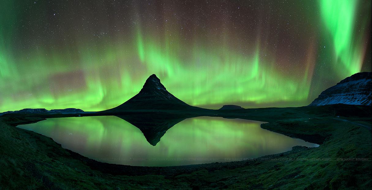
Aurora and starry skies at Mount Kirkjufell, Iceland on April 2, 2014. Credit and copyright: Nanut Bovorn.
Wow! Mount Kirkjufell is a well-known and often-photographed landmark, and there are many who say it is the most beautiful mountain in Iceland. Photographer Nanut Bovorn captured Kirkjufell in all its glory on April 2, 2014, surrounded by starry skies and an incredible aurora. Simply stunning.
Below is another image taken the same night which also shows the beautiful landscape that surrounds Kirkjufell, with a stream and waterfalls, all under the beautiful nights skies in Iceland.
Mount Kirkjufell sits on a little peninsula and is 463 meters high.
Mount Kirkjufell in Iceland surrounded by the aurora on April 2, 2014. Credit and copyright: Nanut Bovorn.
Want to get your astrophoto featured on Universe Today? Join our Flickr group or send us your images by email (this means you’re giving us permission to post them). Please explain what’s in the picture, when you took it, the equipment you used, etc.
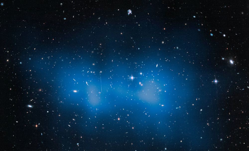
Hubble Space Telescope image of the El Gordo galaxy cluster. This and other gigantic galaxy clusters are challenging the most common theory of the evolution of structure in the Universe. Credit: NASA, ESA, and J. Jee (University of California, Davis)
The Hubble Space Telescope has a new calculation for the huge El Gordo galaxy cluster: 3 million billion times the mass of the Sun. This is even 43 per cent more massive than past estimates that examined the complex in X-rays, NASA stated.
“A fraction of this mass is locked up in several hundred galaxies that inhabit the cluster and a larger fraction is in hot gas that fills the entire volume of the cluster. The rest is tied up in dark matter, an invisible form of matter that makes up the bulk of the mass of the universe,” the Space Telescope Science Institute stated.
“Though galaxy clusters as massive are found in the nearby universe, such as the so-called Bullet Cluster, nothing like this has ever been seen to exist so far back in time, when the universe was roughly half of its current age of 13.8 billion years. The team suspects such monsters are rare in the early universe, based on current cosmological models.”
An intriguing signal could be due to "dark matter annihilations" pops up on the left of this data gathered by NASA's Fermi Gamma-ray Space Telescope. The image on left shows the galactic center in gamma rays with energies between 1 and 3.16 GeV. Red indicates the most activity, and the labels are for pulsars. The image at right has all these gamma-ray sources removed. Credit: T. Linden, Univ. of Chicago
Sometimes a strange signal comes from the dark and it takes a while to figure out what that signal means. In this case, scientists analyzing high-energy gamma rays emanating from the galaxy’s center found an unexplained source of emission that they say is “consistent with some forms of dark matter.”
The data came courtesy of NASA’s Fermi Gamma-ray Space Telescope and was analyzed by a group of independent scientists. They found that by removing all known sources of gamma rays, they were left with gamma-ray emissions that so far, they cannot explain. More observations will be needed to characterize these emissions, they cautioned.
Also, the location of the radiation at the galaxy’s center is an interesting spot, since scientists believe that’s where dark matter would lurk since the insofar invisible substance would be the base of normal structures like galaxies.
“The new maps allow us to analyze the excess and test whether more conventional explanations, such as the presence of undiscovered pulsars or cosmic-ray collisions on gas clouds, can account for it,” stated Dan Hooper, an astrophysicist at Fermilab and lead author of the study.
“The signal we find cannot be explained by currently proposed alternatives and is in close agreement with the predictions of very simple dark matter models.”
The scientists suggest that if WIMPs were destroying each other, this would be “a remarkable fit” for a dark matter signal. They again caution, though, that there could be other explanations for the phenomenon.
“Dark matter in this mass range can be probed by direct detection and by the Large Hadron Collider (LHC), so if this is dark matter, we’re already learning about its interactions from the lack of detection so far,” stated co-author Tracy Slatyer, a theoretical physicist at the Massachusetts Institute of Technology.
“This is a very exciting signal, and while the case is not yet closed, in the future we might well look back and say this was where we saw dark matter annihilation for the first time.”
Climate change is now affecting every continent and ocean says the latest report by the Intergovernmental Panel on Climate Change (IPCC), an international collaboration of more than 2,500 experts. If we don’t act soon to bring greenhouse gas emissions under control, the problems will only grow substantially worse. This isn’t a casual statement from a few fringe scientists: nearly 500 people had to sign off on the exact wording of the summary, including 66 expert authors, 271 officials from 115 countries, and 57 observers.
The report is the second of three installments of the IPCC’s fifth assessment of climate change. The first installment, released last year, covered the physical science of climate change. It stated with certainty that climate change is very real and that we are the cause. The new report focuses on the impacts of climate change and how to adapt to them. The third installment, which will come out in April, will focus on cutting greenhouse emissions.
Ice in the Arctic is collapsing, the oceans are rising, coral reefs are dying, fresh water supplies are diminishing, and the oceans are becoming more acidic, which is killing certain creatures and stunting the growth of others. Heat waves and heavy rains are escalating, food crops are being damaged, disease is spreading, human beings will be displaced due to flooding, animals are migrating toward the poles or going extinct, and the worst is yet to come.
The evidence the world is warming is indubitable.
And yet climate change deniers are still represented the world over. Most notably, the Heartland Institute weighed in on the report by focusing on the benefits of climate change. The group’s take on the matter reads like a crude April Fool’s joke.
A Wall Street Journal op-ed by Matt Ridley has also gained quite a bit of attention. An article in Climate Science Watch refers to his piece as “a laundry list of IPCC misrepresentations.” Ridley fails to cite the data presented in the latest report and even tries to claim that global warming will have net benefits.
From the sweeping opinion articles to the simple comments posted below online articles, the IPCC report is being tragically misinterpreted. One need only take a quick glance at the data to see that the world is warming and catastrophic effects are already occurring.
Climate change is global. It will not only affect the poorest nations but the world. “Nobody on this planet is going to be untouched by the impacts of climate change,” said Rajendra K. Pachauri, chairman of the IPCC in a news conference presenting the report.
Yes this report is sobering. But it also provides an opportunity. We have the power, the intelligence, and the moral duty to protect our home planet. We cannot reverse the damage. We might not even be able to stop it. But we can minimize it. There is still time.
We can act across all scales — local to global — to help reduce greenhouse gas emissions. But first we must learn to adapt to a changing environment. Many governments are well past the state of acknowledging climate change and are in fact starting to find solutions.
“I think that dealing effectively with climate change is just going to be something great nations do,” said Christopher Field, co-chairman of the working group that wrote the report and an earth scientist at the Carnegie Institution for Science in Stanford.
The state of New York recently ordered an electric utility serving Manhattan and its surrounding suburbs, to spend $1 billion upgrading its system to prevent future damage from flooding and other weather disruptions. In a reaction to the blackouts caused by Hurricane Sandy and the acceptance that more extreme weather is to come, the company will raise flood walls, bury vital equipment and determine whether or not emerging climate risks will demand different actions.
Utility regulators across the States are discussing whether to follow New York’s lead.
While greenhouse gas emissions have begun to decline slightly in many countries, including the United States, those gains are being swamped by emissions from other countries such as China and India. We must make greater efforts to adapt or the warming planet will be inevitable.
“There is no question that we live in a world already altered by climate change,” said Field. The time for action is now.
The successful liftoff of Sentinel-1A in April 2014. Credit: ESA-S.Corvaja, 2014
And we have liftoff — two times over! Launch fans got a double treat yesterday when two space missions successfully left Earth. First came a morning launch at 10:46 a.m. Eastern (2:46 p.m. UTC) when DMSP-19 (a satellite of the Defense Meteorological Satellite Program) took off from Vandenberg Air Force Base in California. You can watch the replay below the jump.
“The satellite launched today is equipped with a sophisticated sensor suite that can capture visible and infrared cloud cover; measure precipitation, surface temperature and soil moisture; and collect specialized global meteorological, oceanographic and solar-geophysical information in all weather conditions. DMSP-19 joins six other satellites in polar orbit providing weather information,” stated Lockheed Martin, the long-standing prime contractor of the program.
And just above this paragraph is the French Guiana launch of Sentinel-1A, the first half of a pair of environmental monitoring satellites that should show the Earth in high-definition to the European Space Agency and customers. Then below the jump you can see the successful separation of Sentinel-1A in space. The launch took place at 5:02 p.m. Eastern (9:02 p.m. UTC).
You can enter NASA’s ‘Take the Plunge’ contest and guess LADEE’s impending lunar impact date, expected on or before April 21, 2014. Credit: NASA
You can enter NASA’s ‘Take the Plunge’ contest and guess LADEE’s impending lunar impact date, expected on or before April 21, 2014. Credit: NASA Contest entry details below – deadline soon[/caption]
When will LADEE hit the Moon for its looming end of mission finale?
NASA’s resoundingly successful LADEE lunar dust exploring mission is nearly out of gas – and needs your help, now!
With its inevitable doom approaching, NASA needs you to summon your thoughts and is challenging you to participate in a ‘Take the Plunge’ contest – figuratively not literally – and guess LADEE’s impending impact date.
LADEE, which stand for Lunar Atmosphere and Dust Environment Explorer, will smack violently into the Moon and scatter into zillions of bits and pieces sometime in the next two and a half weeks, on or before about April 21.
But exactly when will it impact the lunar surface? NASA wants to hear your best guess!
The ‘Take the Plunge’ contest was announced by NASA today, April 4, at a media briefing.
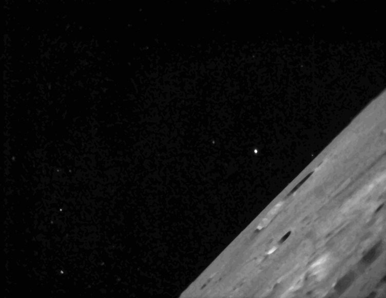
This dissolve animation compares the LRO image (geometrically corrected) of LADEE captured on Jan 14, 2014 with a computer-generated and labeled image of LADEE . LRO and LADEE are both NASA science spacecraft currently in orbit around the Moon. Credit: NASA/Goddard/Arizona State University
Between now and its inevitable doom, mission controllers will command LADEE to continue gathering groundbreaking science.
And it will do so at an even lower attitude that it orbits today by firing its orbit maneuvering thrusters tonight and this weekend.
The couch sized probe seeks to eek out every last smidgeon of data about the Moons ultra tenuous dust and atmospheric environment from an ultra low altitude just a few miles (km) above the pockmarked lunar surface.
But because the moon’s gravity field is so uneven, the probes thrusters must be frequently fired to keep it on course and prevent premature crashes.
“The moon’s gravity field is so lumpy, and the terrain is so highly variable with crater ridges and valleys that frequent maneuvers are required or the LADEE spacecraft will impact the moon’s surface,” said Butler Hine, LADEE project manager at Ames.
“Even if we perform all maneuvers perfectly, there’s still a chance LADEE could impact the moon sometime before April 21, which is when we expect LADEE’s orbit to naturally decay after using all the fuel onboard.”
LADEE will fly as low as fly approximately 1 to 2 miles (2 to 3 kilometers) above the surface.
Everyone of all ages is eligible to enter NASA’s “Take the Plunge: LADEE Impact Challenge.”
The submissions deadline is 3 p.m. PDT Friday, April 11.
NASA says that winners post impact. They will receive a commemorative, personalized certificate from the LADEE program via email.
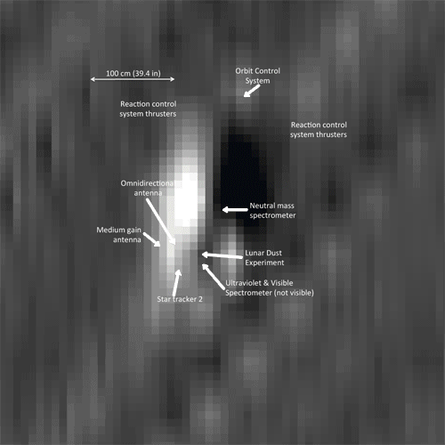
Series of LADEE star tracker images features the lunar terrain. Credit: NASA Ames
Watch for my upcoming story on LADEE’s science accomplishments and what’s planned for her final days.
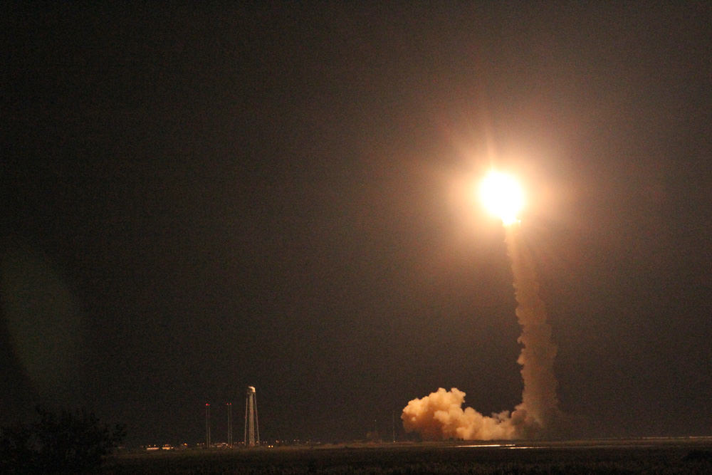
LADEE was launched on Sept. 6, 2013 from NASA Wallops in Virginia on a science mission to investigate the composition and properties of the Moon’s pristine and extremely tenuous atmosphere, or exosphere, and untangle the mysteries of its lofted lunar dust dating back to the Apollo Moon landing era.
Launch of NASA’s LADEE lunar orbiter on Friday night Sept. 6, at 11:27 p.m. EDT on the maiden flight of the Minotaur V rocket from NASA Wallops, Virginia, viewing site 2 miles away. Antares rocket launch pad at left. Credit: Ken Kremer/kenkremer.com
The science mission duration had initially been planned to last approximately 100 days and finish with a final impact on the Moon on about March 24th.
NASA granted LADEE a month long extension since the residual rocket fuel is more than anticipated due to the expertise of LADEE’s navigation engineers and the precision of the launch atop the Orbital Sciences Minotaur V rocket and orbital insertion.
Stay tuned here for Ken’s continuing LADEE, Chang’e-3, Orion, Orbital Sciences, SpaceX, commercial space, Mars rover and more planetary and human spaceflight news.
Learn more at Ken’s upcoming presentations at the NEAF astro/space convention, NY on April 12/13 and at Washington Crossing State Park, NJ on April 6.
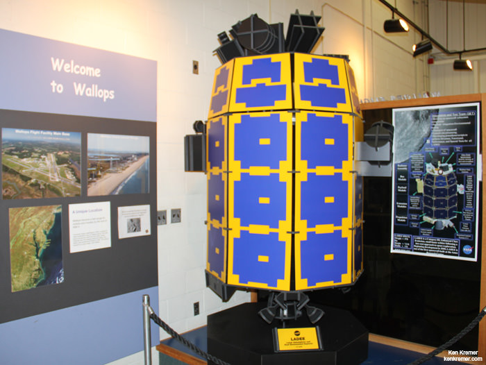
Full scale model of NASA’s LADEE lunar orbiter on display at the free visitor center at NASA’s Wallops Flight Facility in Virginia. Credit: Ken Kremer/kenkremer.com
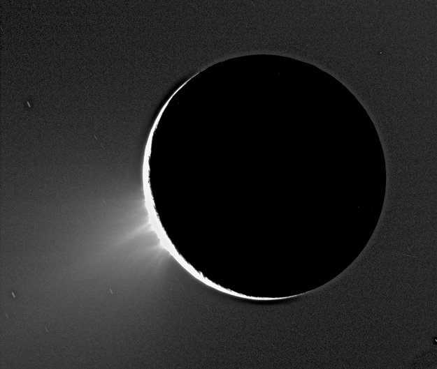
Jets of icy particles bursting from Saturn's moon Enceladus are shown in this Cassini image taken on November 2005. Credit: NASA/ESA/ASI.
Ever since the Cassini spacecraft first spied water vapor and ice spewing from fractures in Enceladus’ frozen surface in 2005, scientists have hypothesized that a large reservoir of water lies beneath that icy surface, possibly fueling the plumes. Now, gravity measurements gathered by Cassini have confirmed that this enticing moon of Saturn does in fact harbor a large subsurface ocean near its south pole.
“For the first time, we have used a geophysical method to determine the internal structure of Enceladus, and the data suggest that indeed there is a large, possibly regional ocean about 50 kilometers below the surface of the south pole,” says David Stevenson from Caltech, a coauthor on a paper on the finding, published in the current issue of the journal Science. “This then provides one possible story to explain why water is gushing out of these fractures we see at the south pole.”
Artist’s impression of the possible interior of Enceladus based on Cassini’s gravity investigation. The data suggest an ice outer shell and a low-density, rocky core with a regional water ocean sandwiched between at high southern latitudes. Cassini images were used to depict the surface geology in this artwork. The mission discovered plumes of ice and water vapour jetting from fractures – nicknamed ‘tiger stripes’ – at the moon’s south pole in 2005. Credit: NASA/JPL-Caltech.
On three separate flybys in 2010 and 2012, the spacecraft passed within 100 km of Enceladus, twice over the southern hemisphere and once over the northern hemisphere.
During the flybys, the gravitational tug altered a spacecraft’s flight path ever so slightly, changing its velocity by just 0.2–0.3 millimeters per second.
As small as these deviations were, they were detectable in the spacecraft’s radio signals as they were beamed back to Earth, providing a measurement of how the gravity of Enceladus varied along the spacecraft’s orbit. These measurements could then be used to infer the distribution of mass inside the moon.
For example, a higher-than-average gravity ‘anomaly’ might suggest the presence of a mountain, while a lower-than-average reading implies a mass deficit.
On Enceladus, the scientists measured a negative mass anomaly at the surface of the south pole, accompanied by a positive one some 30-40 km below.
“By analyzing the spacecraft’s motion in this way, and taking into account the topography of the moon we see with Cassini’s cameras, we are given a window into the internal structure of Enceladus,” said lead author Luciano Iess.
“This is really the only way to learn about internal structure from remote sensing,” Stevenson added.
The only way to get more precise measurements would be to put seismometers on Enceladus’s surface. And that’s not going to happen anytime soon.
Stevenson said the key feature in the gravity data was the negative mass anomaly at Enceladus’s south pole. This happens when there is less mass in a particular location than would be expected in the case of a uniform spherical body. Since there is a known depression in the surface of Enceladus’s south pole, the scientists expected to find a negative mass anomaly. However, the anomaly was quite a bit smaller than would be predicted by the depression alone.
“The perturbations in the spacecraft’s motion can be most simply explained by the moon having an asymmetric internal structure, such that an ice shell overlies liquid water at a depth of around 30–40 km in the southern hemisphere,” Iess said.
While the gravity data cannot rule out a global ocean, a regional sea extending from the south pole to 50 degrees S latitude is most consistent with the moon’s topography and high local temperatures observed around the fractures – called ‘tiger stripes’ at Enceladus south pole.
Many have said Enceladus is one of the best places in the Solar System to look for life. Noted scientist Carolyn Porco and Chris McKay have a recent paper out titled, “Follow the Plume: The Habitability of Enceladus,” where they say that since analysis of the plume by the Cassini mission indicates that the “steady plume derives from a subsurface liquid water reservoir that contains organic carbon, biologically available nitrogen, redox energy sources, and inorganic salts” that samples from the plume jetting out into space are accessible with a low-cost flyby mission. “No other world has such well-studied indications of habitable conditions.”
These latest findings by Cassini make a mission to Enceladus even more enticing.