The movie ‘Gravity’ ended up being a force to reckon with at the 86th Academy Awards on Sunday, with the space thriller pulling in seven Oscars — including Best Director.
Starring Sandra Bullock and George Clooney, the movie followed the aftermath of an orbital disaster. Despite criticism from some about the movie’s accuracy, the film picked up 10 nominations and numerous good vibes from critics. (The movie has a 97% “Fresh” rating on Rotten Tomatoes). You can see congratulations from NASA astronauts Mike Massimino and Cady Coleman below the jump.
“Like any other human endeavor, a film is a transformative experience, and I want to thank Gravity because for many of us involved in this film, it was definitely a transformative experience,” said director Alfonso Cuarón in his acceptance speech last night (March 2).
“And it’s good because it took so long, if not, it would be a waste of time. It really sucks,” he joked, “because for a lot of people, the transformative experience was wisdom. For me, it was just the colour of my hair.”
Among the people Cuarón paid tribute to was Sandra Bullock, who was nominated for ‘Best Lead Actress’ but lost out to Cate Blanchett, who won for her performance in Blue Jasmine.
Sandra Bullock in a still from the movie ‘Gravity.’ Credit: Regency Enterprises/Warner Bros. Entertainment
“You’re Gravity,’ Cuarón said to Bullock from the stage. “You’re the soul, heart of the film. You’re a most amazing collaborator and one of the best people I’ve ever met.”
The movie attracted 7 wins of its 10 Oscar nominations, failing to earn ‘Best Picture’ (which went to 12 Years A Slave), ‘Achievement in Production Design’ (given to American Hustle). and ‘Best Lead Actress’ Its wins were:
Best director (Alfonso Cuarón);
Achievement in cinematography (Emmanuel Lubezki);
Achievement in film editing (Alfonso Cuarón and Mark Sanger);
Achievement in music written for motion pictures (Original score) (Steven Price);
Achievement in sound editing (Glenn Freemantle);
Achievement in sound mixing (Skip Lievsay, Niv Adiri, Christopher Benstead and Chris Munro);
Achivement in visual effects (Tim Webber, Chris Lawrence, Dave Shirk and Neil Corbould).
And if you’re interested in looking back, here’s an archive to all the past Carnivals of Space. If you’ve got a space-related blog, you should really join the carnival. Just email an entry to [email protected], and the next host will link to it. It will help get awareness out there about your writing, help you meet others in the space community – and community is what blogging is all about. And if you really want to help out, sign up to be a host. Send an email to the above address.
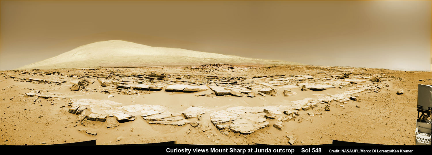
Mars rock rows and Mount Sharp. Martian landscape scene with rows of striated rocks in the foreground and Mount Sharp on the horizon. NASA's Curiosity Mars rover paused mid drive at the Junda outcrop to snap the component images for this navcam camera photomosaic on Sol 548 (Feb. 19, 2014) and then continued traveling southwards towards mountain base. UHF Antenna at right. Credit: NASA/JPL-Caltech/Marco Di Lorenzo/Ken Kremer-kenkremer.com
Mars rock rows and Spectacular Mount Sharp
Martian landscape scene with rows of striated rocks in the foreground and spectacular Mount Sharp on the horizon. NASA’s Curiosity Mars rover paused mid drive at the Junda outcrop to snap the component images for this colorized navcam camera photomosaic on Sol 548 (Feb. 19, 2014) and then continued traveling southwards towards mountain base. UHF Antenna at right.
Credit: NASA/JPL-Caltech/Marco Di Lorenzo/Ken Kremer-kenkremer.com
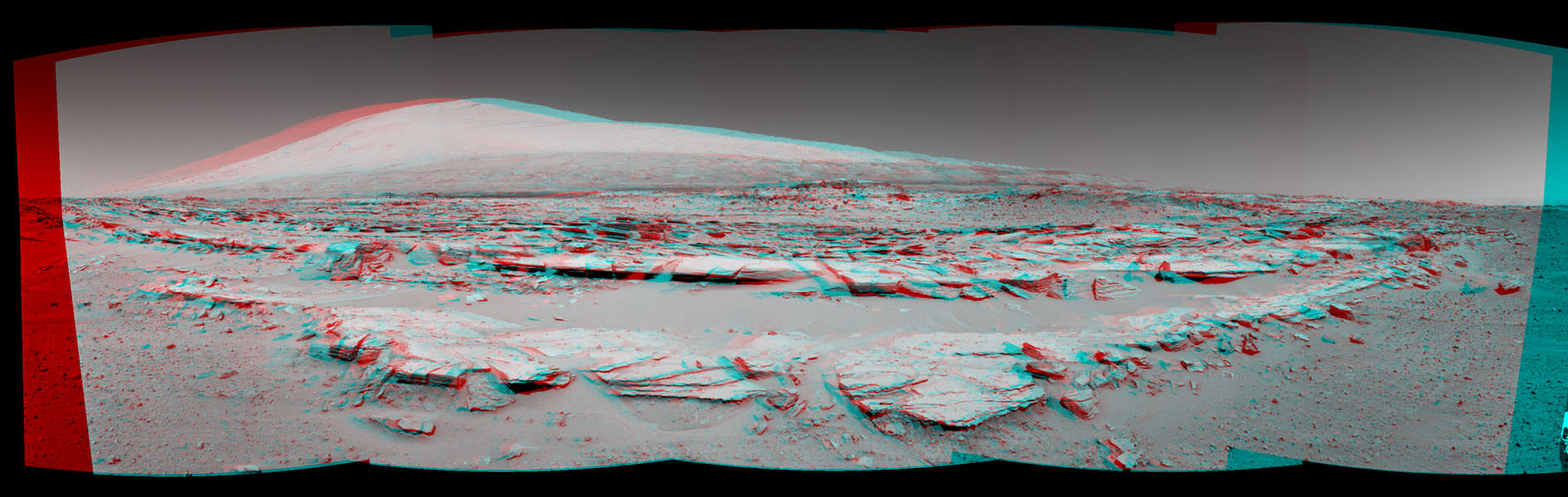
See stereo 3-D and look back views below[/caption]
Like any good tourist, NASA’s rover Curiosity apparently couldn’t resist the photobug urge from a gorgeous Martian mountain scene she happened by recently and decided to pull over and enjoy the view.
So she stopped the dune buggy mid-drive on the sandy road to her daily destination one Sol last week on Feb. 19, powered up the camera suite and excitedly snapped a spectacular landscape view of a striated rock field dramatically back dropped by towering Mount Sharp on the horizon.
See our Mars rocks and Mount Sharp photomosaic above and a 3-D stereoscopic view from NASA below.
The sedimentary foothills of Mount Sharp, which reaches 3.4 miles (5.5 km) into the Martian sky, is the 1 ton robots ultimate destination inside Gale Crater because it holds caches of water altered minerals.
Martian Landscape With Rock Rows and Mount Sharp (Stereo) This stereo landscape scene from NASA’s Curiosity Mars rover on Feb. 19, 2014 shows rows of rocks in the foreground and Mount Sharp on the horizon. It appears three dimensional when viewed through red-blue glasses with the red lens on the left. Credit: NASA/JPL-Caltech
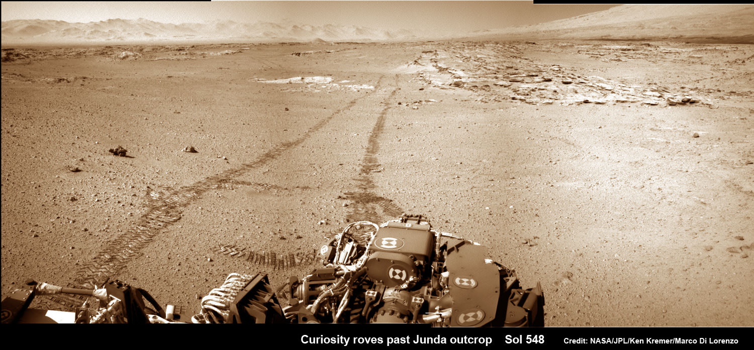
And just for good measure, Curiosity also snapped a series of breathtaking look back photos showing her tracks in the dune filled terrain from whence she came since straddling through the Dingo Gap gateway. See our mosaics below.
The panoramic mountain view taken on Sol 548 shows rows of striated rocks all oriented in a similar direction in the foreground with Mount Sharp in the background.
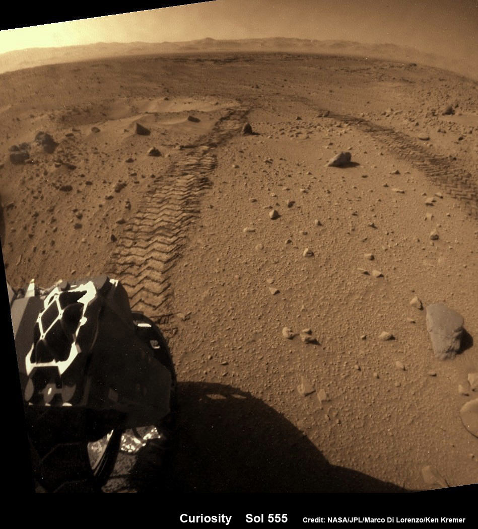
Curiosity looks back across dune field to her wheel tracks and a small crater she just missed. Flattened rear hazcam image, colorized from Sol 555 (Feb 27, 2014). Credit: NASA/JPL-Caltech/Marco Di Lorenzo/Ken Kremer-kenkremer.com
Scientists directed Curiosity to drive by the rock rows nicknamed “Junda” after their interest was piqued by orbital images taken by the powerful telescopic camera on NASA’s Mars Reconnaissance Orbiter (MRO) circling overhead.
The six wheeled rover paused during the planned Feb. 19 drive of 328 feet (100 meters) to capture the imagery.
She then pushed forward to finish the day’s drive and snapped another fabulous look back view – see our mosaic below.
And the next day on Feb. 20 (Sol 549), she also completed her second 100 meter drive in reverse.
Her handlers are occasionally commanding Curiosity to drive backwards in a newly tested bid to minimize serious damage to the six 20 inch diameter wheels in the form of rips and tears caused by rough edged Red Planet rocks – see our wheel mosaic below.
Curiosity looks back at Martian sand dunes and rover tracks after passing by Junda outcrop (right) on Sol 548 (Feb. 19, 2014) with Gale Crater rim and Mount Sharp on the distant horizon. Navcam colorized photomosaic. Credit: NASA/JPL-Caltech/Ken Kremer- kenkremer.com/Marco Di Lorenzo
Curiosity is well on the way to her next near term goal, which is a science waypoint, named Kimberly (formerly called KMS-9), which lies about half a mile ahead.
Kimberly is of interest to the science team because it sits at an the intersection of different rock layers and also features ground with striations like those at “Junda”.
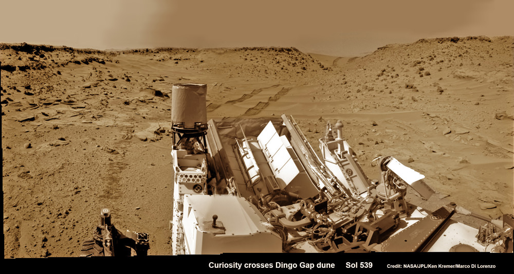
Curiosity looks back eastward to ‘Dingo Gap’ sand dune inside Gale Crater. After crossing over the 3 foot (1 meter) tall dune on Sol 539, Feb. 9, 2014 the rover drove westward into the ‘Moonlight Valley’. The parallel rover wheel tracks are 9 feet (2.7 meters) apart. Assembled from Sol 539 colorized navcam raw images. Credit: NASA/JPL/ Ken Kremer- kenkremer.com/Marco Di Lorenzo
So, after the rover reaches Kimberly, researchers plan to temporarily halt driving for awhile to investigate the location and direct the robot to drill into another rock to collect samples for analysis by the two state- of-the -art chemistry labs.
If drilling is warranted, Kimberly would be the site of Curiosity’s first drilling operation since the Cumberland outcrop target was bored into during the spring of 2013 at Yellowknife Bay.
Curiosity departed the Yellowknife Bay region in July 2013 where she discovered a habitable zone and thereby accomplished the primary goal of the mission.
To date Curiosity’s odometer stands at 5.3 kilometers and she has taken over 125,000 images.
The robot has somewhat less than another 5 km to go to reach the base of Mount Sharp.
She perhaps may arrive sometime in mid 2014.
Arrival time at Mount Sharp depends on driving speed and whether the upcoming terrain is smoother or strewn with sharp edged rocks that have hindered progress due to accumulating wear and tear on the aluminum wheels.
Up close photomosaic view shows lengthy tear in rover Curiosity’s left front wheel caused by recent driving over sharp edged Martian rocks on the months long trek to Mount Sharp. Raw images taken by the MAHLI camera on Curiosity’s arm on Jan. 31, 2014 (Sol 529) were assembled to show some recent damage to several of its six wheels Credit: NASA / JPL / MSSS / Marco Di Lorenzo / Ken Kremer- kenkremer.com See below complete 6 wheel mosaic and further wheel mosaics for comparison
Stay tuned here for Ken’s continuing Curiosity, Opportunity, Chang’e-3, GPM, SpaceX, Orbital Sciences, LADEE, MAVEN, MOM, Mars and more planetary and human spaceflight news. Learn more at Ken’s upcoming presentations at the NEAF convention on April 12/13.
Curiosity’s View Past Tall Dune at edge of ‘Dingo Gap’
This photomosaic from Curiosity’s Navigation Camera (Navcam) taken at the edge of the entrance to the Dingo Gap shows a 3 foot (1 meter) tall dune and valley terrain beyond to the west, all dramatically back dropped by eroded rim of Gale Crater. View from the rover’s current position on Sol 528 (Jan. 30, 2014). The rover team may decide soon whether Curiosity will bridge the dune gap as a smoother path to next science destination. Credit: NASA/JPL-Caltech/Marco Di Lorenzo/Ken Kremer- kenkremer.com
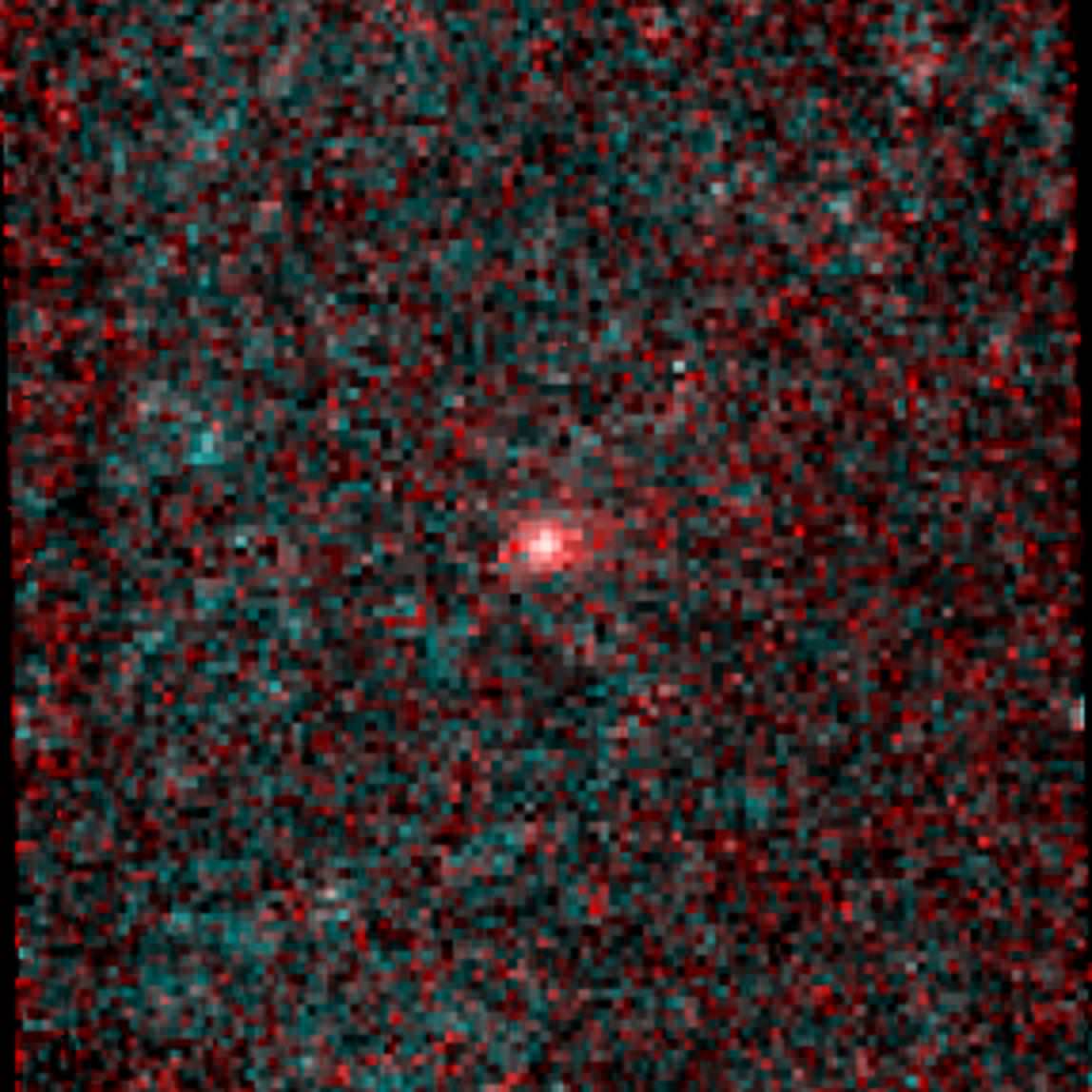
Infrared image of comet NEOWISE (C/2014 C3). Credit: NASA/JPL-Caltech
NASA’s NEOWISE mission — formerly known as just WISE — has identified the first comet of its new near-Earth object hunting career… and, according to mission scientists, it’s a “weirdo.”
In its former life NASA’s WISE (Wide-field Infrared Survey Explorer) spacecraft scanned the entire sky in infrared wavelengths. It helped discover the galaxy’s coldest stars, the Universe’s brightest galaxies, and some of the darkest asteroids lurking in the main asteroid belt between Mars and Jupiter… as well as closer in to Earth’s neck of the woods.
After exhausting its supply of liquid coolant needed to shield itself from its own radiating heat, in 2011 WISE was put into a state of hibernation. It was awoken last year and rebranded NEOWISE, and set upon the task of locating unknown objects with orbits in the proximity of Earth’s.
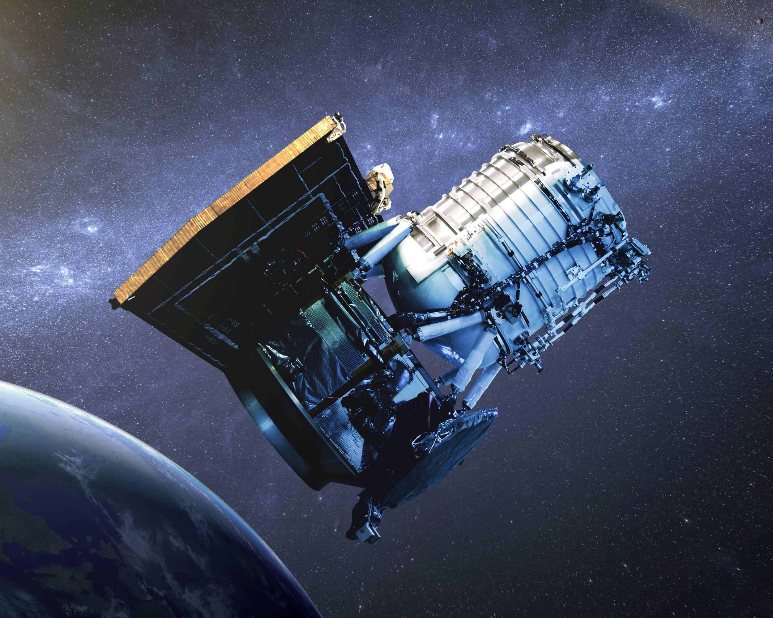
Artist’s impression of the WISE satellite
To date several new asteroids have already been found by NEOWISE, and on February 14, 2014, it spotted its first comet.
“We are so pleased to have discovered this frozen visitor from the outermost reaches of our solar system,” said Amy Mainzer, NEOWISE principal investigator at JPL. “This comet is a weirdo — it is in a retrograde orbit, meaning that it orbits the sun in the opposite sense from Earth and the other planets.”
Designated “C/2014 C3 (NEOWISE),” the comet was 143 million miles (230 million km) away in the image above — a composite made from six infrared exposures. That’s 585 times the distance to the Moon, or about the average distance between the Earth and Mars.
The tail of the comet NEOWISE extends about 25,000 miles (40,000 km) to the right in the image.
Overall, C/2014 C3 (NEOWISE) was spotted six times before it moved out of range of the spacecraft’s view. The comet has a highly-eccentric 20-year orbit that takes it high above the plane of the Solar System and out past the orbit of Jupiter. Technically, with a perihelion distance greater than 1.3 AU, comet C/2014 C3 does not classify as a near-Earth object (and its orbit does not intersect Earth’s.) But it’s still good to know that NEOWISE is looking out for us.
Rise of Venus and the Milky Way in Singapore on Feb. 28, 2014. Credit and copyright: Justin Ng.
“My dream to capture the beautiful Milky Way galaxy in Singapore has finally come true this morning after the monsoon season is over,” said noted astrophotographer Justin Ng, who lives in this island country in South East Asia. Justin noted that since Singapore is known for its heavy light pollution, there are many people who believe it’s impossible to capture stars and the arc of the Milky Way under those conditions. Justin has been taking amazing deep sky and night sky photos for quite some time, but he said with this particular image he’s hoping to prove the naysayers wrong.
“Plus, I hope to inspire more astrophotographers residing in heavily light polluted city to try to capture these ‘impossible’ images,” Justin added.
UPDATE: Below is a new timelapse video from Justin Ng.
This is a single exposure shot of planet Venus and Milky Way Galaxy in Singapore. However, the light pollution near the horizon is also visible.
Justin has now created a timelapse of his Milky Way photography from the same night he took this image, and he says a timelapse like this never been attempted by any photographers in Singapore, this is is the first:
Want to get your astrophoto featured on Universe Today? Join our Flickr group or send us your images by email (this means you’re giving us permission to post them). Please explain what’s in the picture, when you took it, the equipment you used, etc.
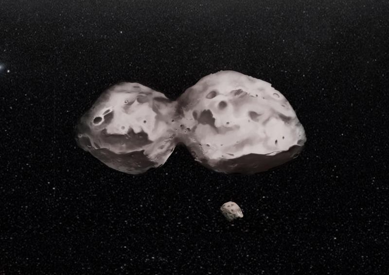
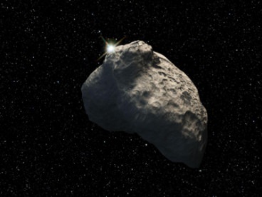
Artist's impression of 624 Hektor, the largest known Trojan asteroid. The dual asteroid is 155 miles (250 kilometers) at its widest. It also has a 7.5-mile (12-mile) moon. Credit: H. Marchis/F. Marchis
Two icy asteroids could have crashed into each other early in the solar system’s history to form the strange-looking 624 Hektor, new research reveals. The 155-mile (250-kilometer) asteroid is the largest known Trojan asteroid, or space rock that follows along with Jupiter in the gas giant’s orbital path.
Hektor also has a moon, which was first discovered in 2006 by another team led by the same lead author, the SETI Institute’s Franck Marchis. It’s taken the astronomers about eight years to get a handle on the complex orbit of the system, a topic that the new research examines in detail. That was partly because the path was so “bizarre”, the team stated, and also because time on the W.M. Keck Observatory telescopes (used to perform the observations) is limited. There are few other observatories that could do the same work, the team added.
The moon, which is about 7.5 miles or 12 kilometers in diameter, orbits its parent asteroid every three days. The moon’s path is about 373 miles (600 km) distant and inclined almost at 45 degrees to the asteroid’s equator.
The Trojan asteroid 624 Hektor is visible in these two adaptive optics observations in July 2006 and October 2008, both performed with the W.M. Keck Observatory’s II telescope. Hektor is in the middle of each picture, and its moon in the circles. Credit: WMKO/Marchis
“The orbit of the moon is elliptical and tilted relative to the spin of Hektor, which is very different from other asteroids with satellites seen in the main-belt,” stated Matija Cuk, a paper co-author who is a scientist at the Carl Sagan Center of the SETI Institute. “However, we did computer simulations, which include Hektor being a spinning football shape asteroid and orbiting the Sun, and we found that the moon’s orbit is stable over billions of years.”
While the artist’s conception above shows Hektor as a peanut, the exact shape is still not known for sure. The models and the adaptive optics suggest that it is likely a dual-lobe asteroid. What is better known, however, is that the asteroid is “extremely elongated” and spins in less than seven hours.
The origin of the moon is unclear, but the researchers suggested it could be because of ejecta associated with the collision that formed the asteroid. They said more simulations are needed on that point. What’s more, Hektor has another mystery associated with its composition.
An artist’s rendering of a Kuiper Belt object. Image: NASA
“We also show that Hektor could be made of a mixture of rock and ices, similar to the composition of Kuiper belt objects, Triton and Pluto. How Hektor became a Trojan asteroid, located at only 5 times the Earth–Sun distance, is probably related to the large scale reshuffling that occurred when the giant planets were still migrating,” stated Julie Castillo-Rogez, a researcher at NASA’s Jet Propulsion Laboratory who participated in the research.
You can read more about the research in Astrophysical Journal Letters. By the way, the moon does not have a name yet, and the researchers said they are looking for any ideas as long as it fulfills a couple of ideas: “the satellite should receive a name closely related to the name of the primary and reflecting the relative sizes between these objects.” Feel free to share your suggestions in the comments.
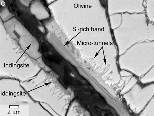
A scanning electron microscope image of a small section of a meteorite found evidence of past water in a Martian meteorite (specifically, in the form of tunnels and microtunnels). The meteorite is called
Yamato 000593. The rock was originally recovered in Antarctica in 2000 and is believed to have come from Mars. Credit: NASA
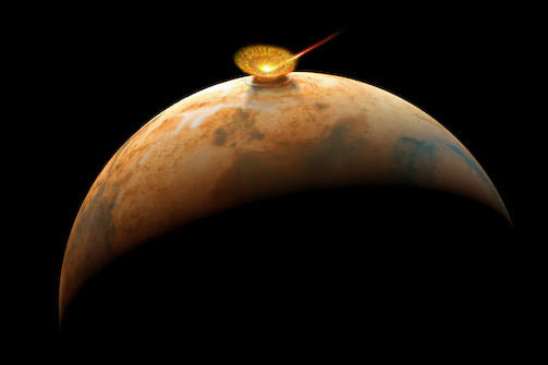
Could this meteorite show evidence of ancient water and life on Mars? That’s one possibility raised in a new paper led by NASA and including members of a team who made a contentious claim about Martian microfossils in another meteorite 18 years ago.
“This is no smoking gun,” stated lead author Lauren White, who is based at NASA’s Jet Propulsion Laboratory, of the findings released this week. “We can never eliminate the possibility of contamination in any meteorite. But these features are nonetheless interesting and show that further studies of these meteorites should continue.”
The new, peer-reviewed work focuses on tunnels and microtunnels the scientists said they found in a meteorite called Yamato 00593. The meteorite is about 30 pounds (13.7 kilograms) and was discovered in Antarctica in 2000. The structures were found deep within the rock, NASA stated, and “suggest biological processes might have been at work on Mars hundreds of millions of years ago.”
Scientists believe the 1.3-billion-year-old rock left Mars about 12 million years ago after an impact threw it off the surface. It reached Antarctica 50,000 years ago and after it was found in 2000, was analyzed and believed to be a “nakhlite”, or a kind of Martian meteorite. “Martian meteoritic material is distinguished from other meteorites and materials from Earth and the moon by the composition of the oxygen atoms within the silicate minerals and trapped Martian atmospheric gases,” NASA stated.
An asteroid impacts ancient Mars and send rocks hurtling to space – some reach Earth
There are two things in the meteorite that caught the attention of scientists. One is the aforementioned tunnels and microtunnels, which they say are similar to those altered by bacteria in basalt on Earth. The second is tiny, carbon-enriched spherules (in the nanometer to micrometer range) between layers in the rock — structures similar to another Martian meteorite (Nakhla) that struck Egypt in 1911. In that case, the rock was recovered quickly after landing and still had the same spherules, the researchers noted.
The authors said it’s possible that these structures could be explained by other mechanisms besides life, but said the similarities to what they have found on Earth “imply the intriguing possibility that the Martian features were formed by biotic activity.”
The research team includes NASA’s David McKay (who died a year ago), Everett Gibson and Kathie Thomas-Keptra. In 1996, these same scientists (then led by McKay) found “biogenic evidence” in a meteorite called Allen Hills 84001, but other science teams have disagreed with the findings. There have been a lot of papers about this particular meteorite, and you can read more about the controversy in this 2011 Universe Today article.
Climate change is one of the defining issues of our time. So begins the latest report by the U.S. National Academy of Sciences and the United Kingdom’s Royal Society. The two institutions agree: climate change is not only indisputable, it’s largely the result of human activities.
The bulk of the 36-page report is presented in a question-and-answer format, making it a good bed-side read. But in case you don’t want to have nightmares about surging temperatures or polar bears alone on breaking ice caps, we’ll leaf through the intriguing points here.
In a forward to the report, Dr. Ralph J. Cicerone, president of the National Academy of Sciences, and Sir Paul Nurse, president of the Royal Society argue that multiple lines of evidence show that humans are changing Earth’s climate. This is now more certain than ever.
They are careful to include a caveat: “The evidence is clear. However, due to the nature of science, not every single detail is ever totally settled or completely certain. Nor has every pertinent question yet been answered.” Areas of active debate include how much warming to expect in the future and the connections between climate change and extreme weather events such as the frequency and intensity of hurricanes, droughts and floods.
Earth’s global average surface temperature has risen as shown in this plot of combined land and ocean measurements from 1850 to 2012, derived from three independent analyses of the available data sets. Image Credit: National Academy of Sciences / The Royal Society
But the first question: is the climate warming? goes without debate. Yes. Earth’s average surface air temperature has increased by about 0.8 degrees Celsius since 1900, and the last 30 years have been the warmest in 800 years. It’s the most rapid period of sustained temperature change in the scale of global history, trumping every ice age cycle.
Recent estimates of the increase in global temperature since the end of the last ice age are four to five degrees Celsius. While this is much greater than the 0.8 degree Celsius change recorded over the last 100+ years, this change occurred over a period of about 7,000 years. So the change in rate is now 10 times faster.
Of course an increase in temperature goes hand in hand with an increase in carbon emissions. Greenhouse gases such as carbon dioxide absorb heat (infrared radiation) emitted from the Earth’s surface. Increases in the atmospheric concentrations of these gases trap most of the outgoing heat, causing the Earth to warm. Human activities, especially the burning of fossil fuels have increased carbon dioxide concentrations by 40 percent between 1880 and 2012. It is now higher than at any time in at least 800,000 years.
And if the rise in carbon emissions continues unchecked, warming of the same magnitude as the increase out of the last ice age can be expected by the end of this century.
The report continues to ask more controversial questions. Take as an example the question: Does the recent slowdown of warming mean that climate change is no longer happening? The short answer is no. Decades of slow warming and accelerated warming occur naturally in the climate system. Despite the slower rate of warming the 2000’s were still warmer than the 1990’s
The new report builds upon the long history of climate-related work from the United Nations’ Intergovernmental Panel on Climate Change. So while some have argued it doesn’t add anything new to the wealth of climate science data available, it does help make that data more succinct and available to the public. Its goal is to help inform decision makers, policy makers, educators and all other individuals.
The report concludes by noting available options to citizens and governments. They can simply wait and accept the losses, they can change their pattern of energy production, they can attempt to adapt to environmental changes as much as possible, or they can seek as yet unproven geoengineering solutions.
No matter which option we choose, one thing remains certain: the Earth is warming at a tremendous rate and we are the cause.
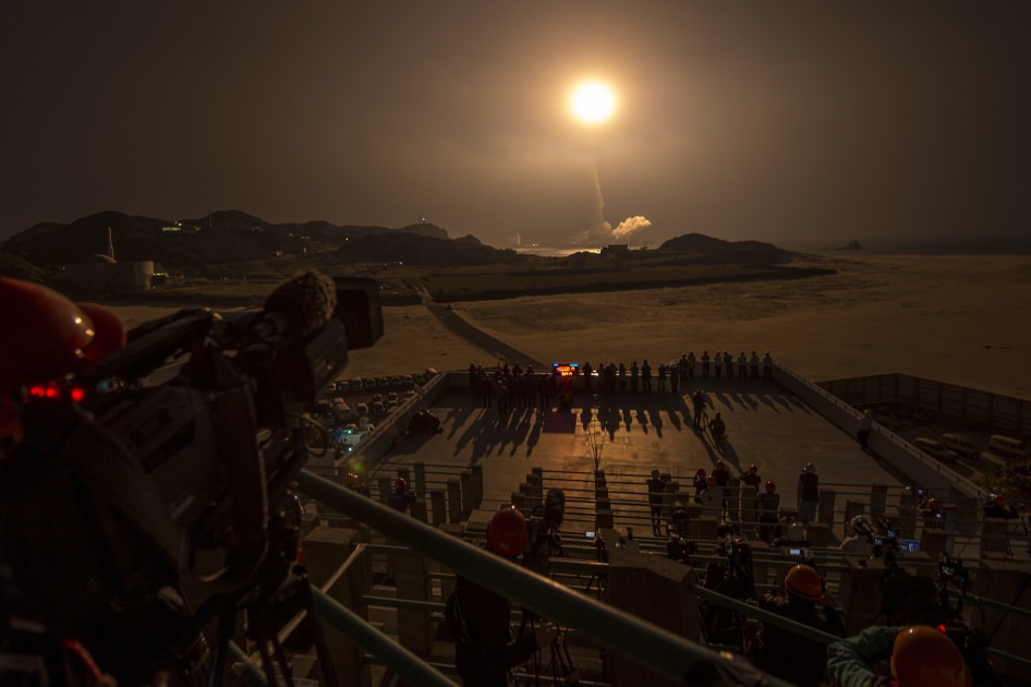
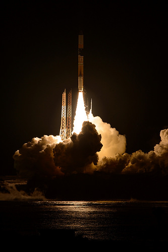
GPM Launch Seen From the Tanegashima Space Center. A Japanese H-IIA rocket with the NASA-Japan Aerospace Exploration Agency (JAXA), Global Precipitation Measurement (GPM) Core Observatory onboard, is seen launching from the Tanegashima Space Center on Friday, Feb. 28, 2014 (Japan Time), in Tanegashima, Japan; Thursday, Feb. 27, EST.. Credit: NASA/Bill Ingalls
GPM Launch Seen From the Tanegashima Space Center
A Japanese H-IIA rocket with the NASA-Japan Aerospace Exploration Agency (JAXA), Global Precipitation Measurement (GPM) Core Observatory onboard, is seen launching from the Tanegashima Space Center on Friday, Feb. 28, 2014 (Japan Time), in Tanegashima, Japan; Thursday, Feb. 27, EST. Credit: NASA/Bill Ingalls[/caption]
NASA GODDARD SPACE FLIGHT CENTER, MARYLAND – A powerful, next generation weather observatory aimed at gathering unprecedented 3-D measurements of global rain and snowfall rates – and jointly developed by the US and Japan – thundered to orbit today (Feb. 27 EST, Feb. 28 JST) ) during a spectacular night time blastoff from a Japanese space port.
The Global Precipitation Measurement (GPM) Core Observatory was launched precisely on time at 1:37 p.m. EST, 1837 GMT, Thursday, Feb. 27 (3:37 a.m. JST Friday, Feb. 28) atop a Mitsubishi Heavy Industries H-IIA rocket from the Tanegashima Space Center on Tanegashima Island off southern Japan.
Viewers could watch the spectacular liftoff live on NASA TV – which was streamed here at Universe Today.
“GPM’s precipitation measurements will look like a CAT scan,” Dr. Dalia Kirschbaum, GPM research scientist, told me during a prelaunch interview with the GPM satellite in the cleanroom at NASA’s Goddard Space Flight Center in Greenbelt, Md.
“The radar can scan through clouds to create a three dimensional view of a clouds structure and evolution.”
GPM lifts off on Feb. 27, EST (Feb. 28, JST) to begin its Earth-observing mission. Credit: NASA/Bill Ingalls
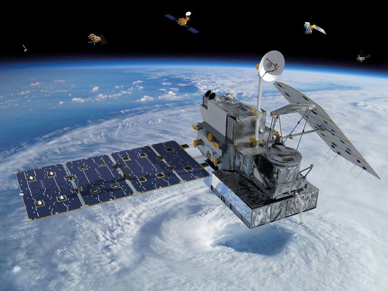
GPM is the lead observatory of a constellation of nine highly advanced Earth orbiting weather research satellites contributed by the US, Japan, Europe and India.
Indeed GPM will be the first satellite to measure light rainfall and snow, in addition to heavy tropical rainfall.
It will collect a treasure trove of data enabling the most comprehensive measurements ever of global precipitation every three hours – and across a wide swath of the planet where virtually all of humanity lives from 65 N to 65 S latitudes.
GPM orbits at an altitude of 253 miles (407 kilometers) above Earth – quite similar to the International Space Station (ISS).
The global precipitation data will be made freely available to climate researchers and weather forecasters worldwide in near real time – something long awaited and not possible until now.
Water and the associated water and energy cycles are the basis of all life on Earth.
Yet scientists lack a clear and comprehensive understanding of key rain and snow fall amounts on most of the globe – which is at the heart of humanity’s existence and future well being on the home planet.
Having an accurate catalog of the water and energy cycles will direct benefit society and impact people’s lives on a daily basis with improved weather forecasts, more advanced warnings of extreme weather conditions, aid farmers, help identify and determine the effects of global climate change.
Researchers will use the GPM measurements to study climate change, freshwater resources, floods and droughts, and hurricane formation and tracking.
“With this launch, we have taken another giant leap in providing the world with an unprecedented picture of our planet’s rain and snow,” said NASA Administrator Charles Bolden, in a NASA statement.
“GPM will help us better understand our ever-changing climate, improve forecasts of extreme weather events like floods, and assist decision makers around the world to better manage water resources.”
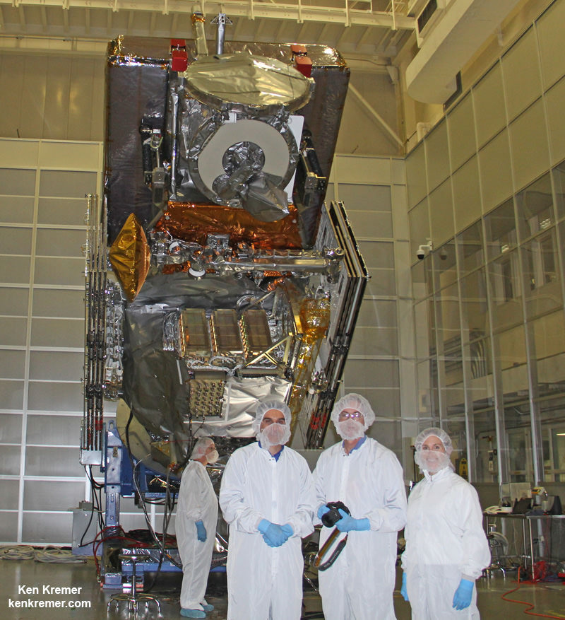
“The GPM spacecraft has been under development for a dozen years,” said GPM Project Manager Art Azarbarzin of NASA’s Goddard Space Flight Center in Greenbelt, Md., in a prelaunch interview with Universe Today conducted inside the clean room with GPM before it’s shipment to Japan.
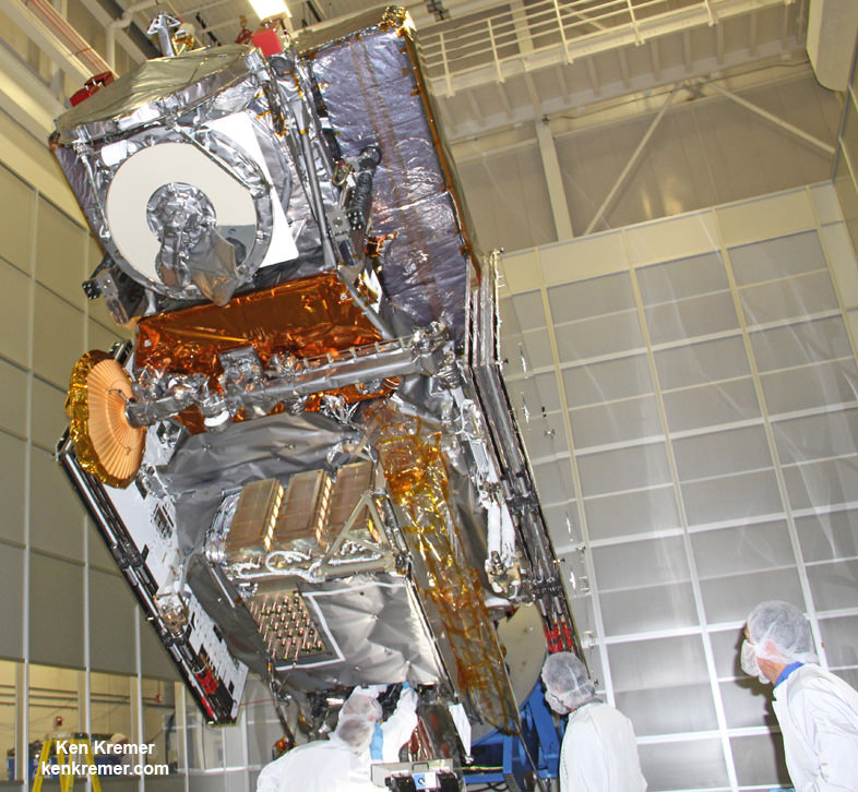
NASA’s next generation Global Precipitation Measurement (GPM) observatory inside the clean room at NASA Goddard Space Flight Center, MD. Technicians at work on final processing during exclusive up-close inspection tour by Universe Today. GPM is slated to launch on February 27, 2014 and will provide global measurements of rain and snow every 3 hours. Credit: Ken Kremer/kenkremer.com
“The GPM satellite was built in house by the dedicated team at NASA’s Goddard Space Flight Center in Maryland,” Azarbarzin told me.
“It’s the largest satellite ever built at Goddard.”
Following the flawless blastoff, the nearly four ton GPM spacecraft separated from the Japanese rocket some 16 minutes later at an altitude of 247 miles (398 kilometers).
10 minutes later both of the spacecrafts life giving solar arrays deployed as planned.
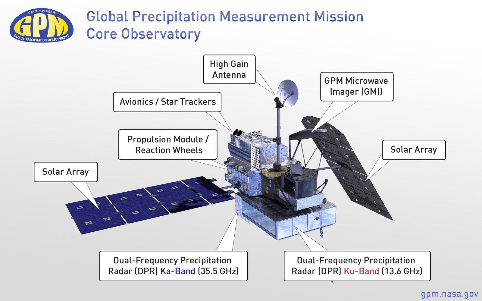
Major components of the GPM Core Observatory labeled, including the GMI, DPR, HGAS, solar panels, and more. Credit: NASA Goddard
“It is incredibly exciting to see this spacecraft launch,” said Azarbarzin, in a NASA statement. He witnessed the launch in Japan.
“This is the moment that the GPM Team has been working toward since 2006.”
“The GPM Core Observatory is the product of a dedicated team at Goddard, JAXA and others worldwide.”
“Soon, as GPM begins to collect precipitation observations, we’ll see these instruments at work providing real-time information for the scientists about the intensification of storms, rainfall in remote areas and so much more.”
The $933 Million observatory is a joint venture between the US and Japanese space agencies, NASA and the Japan Aerospace Exploration Agency (JAXA).
The 3850 kilogram GPM satellite is equipped with two instruments – an advanced, higher resolution dual -frequency precipitation (DPR) radar instrument (Ku and Ka band) built by JAXA in Japan and the GPM microwave imager (GMI) built by Ball Aerospace in the US.
The GPM observatory will replace the aging NASA/JAXA Tropical Rainfall Measuring Mission (TRMM) satellite launched back in 1997 and also jointly developed by NASA and JAXA.
“GPM is the direct follow-up to the currently orbiting TRMM satellite,” Azarbarzin explained to me.
“TRMM is reaching the end of its usable lifetime. After GPM launches we hope it has some overlap with observations from TRMM.”
GPM is vital to continuing the TRMM measurements. It will help provide improved forecasts and advance warning of extreme super storms like Hurricane Sandy and Super Typhoon Haiyan.
“TRMM was only designed to last three years but is still operating today. We hope GPM has a similar long life,” said Azarbarzin.
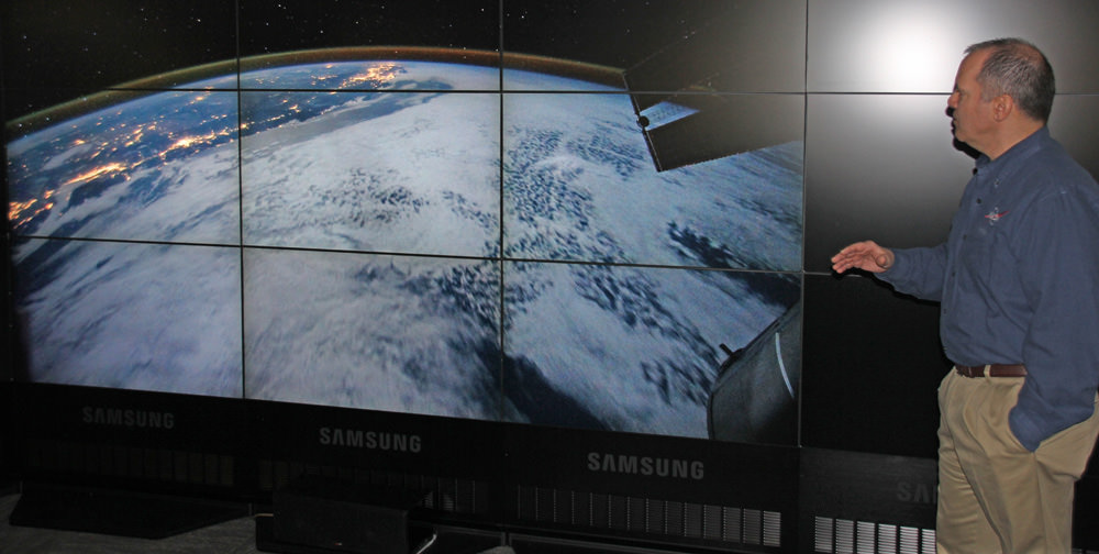
NASA astronaut Paul Richards (STS-102) discusses GPM at NASA Goddard Space Flight Center on Feb. 27, 2014. Credit: Ken Kremer/kenkremer.com
Stay tuned here for Ken’s continuing GPM reports and on-site coverage at NASA Goddard Space Flight Center in Maryland.
And watch for Ken’s continuing planetary and human spaceflight news about Curiosity, Opportunity, Chang’e-3, SpaceX, Orbital Sciences, LADEE, MAVEN, MOM, Mars, Orion and more.
Visualization of the GPM Core Observatory and Partner Satellites. GPM launched on Feb. 27 from Japan. Credit: NASANASA/JAXA Global Precipitation Measurement (GPM) satellite inside the clean room at NASA Goddard Space Flight Center, MD, undergoes final processing during exclusive up-close inspection tour by Universe Today: Dr. Art Azarbarzin/NASA GPM project manager, Dr. Ken Kremer/Universe Today and Dr. Dalia Kirschbaum/NASA GPM research scientist. Credit: Ken Kremer/kenkremer.com