Illustration from Parker et al, 2008, of the decomposition of the main-belt asteroid population into families and background
objects in proper a vs. sin(i) (left panels) and proper a vs. e (right panels). The top panels show all
(background and family) objects in the data subset. The two middle panels show objects from 37 identi?ed
families, and the bottom two panels show the background population. Credit: Parker et al, 2008.
Who knew asteroids could be so beautiful and mesmerizing? In 2008, a group of astronomers led by Alex Parker did a study of the size distribution of asteroid families using data from the Sloan Digital Sky Survey. Asteroid families often have distinctive optical colors, the team said, and they were able to offer an improved way to separate out the family members into their colors. This resultant animation put together just this week by Parker shows the orbital motions of over 100,000 asteroids, with colors illustrating the compositional diversity and relative sizes of the asteroids.
“The compositional gradient of the asteroid belt is clearly visible,” says Parker, “with green Vesta-family members in the inner belt fading through the blue C-class asteroids in the outer belt, and the deep red Trojan swarms beyond that.”
All main-belt asteroids and Trojan asteroids with orbits known to high precision are shown in the video and the animation is rendered with a timestep of 3 days. Via Twitter, Parker said this animation took — from start to finish — 20 hours to render on 8 CPUs.
For reference, the average orbital distances of Mercury, Venus, Earth, Mars, and Jupiter are illustrated with rings.
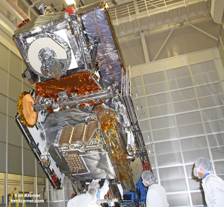
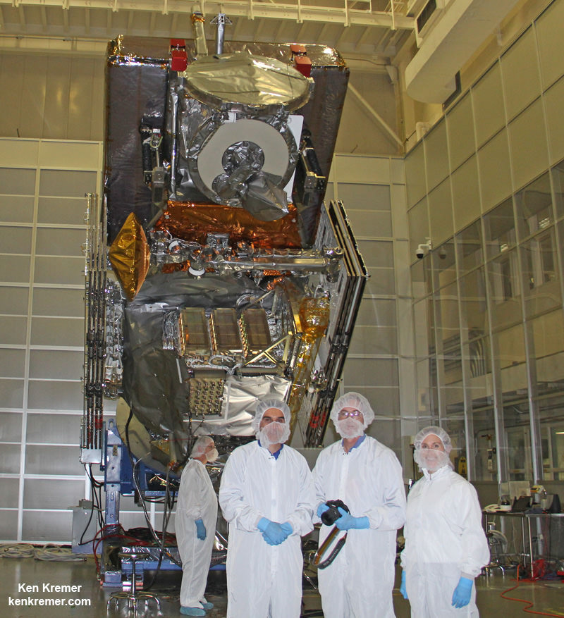
NASA’s next generation Global Precipitation Measurement (GPM) observatory inside the clean room at NASA Goddard Space Flight Center, MD. Technicians at work on final processing during exclusive up-close inspection tour by Universe Today. GPM is slated to launch on February 27, 2014 and will provide global measurements of rain and snow every 3 hours. Credit: Ken Kremer/kenkremer.com
NASA GODDARD SPACE FLIGHT CENTER, MARYLAND – Weather researchers and forecasters worldwide are gushing with excitement in the final days leading to blastoff of the powerful, new Global Precipitation Measurement (GPM) Core Observatory – built by NASA in a joint effort with Japan.
GPM is a next-generation satellite that will provide global, near real time observations of rain and snow from space and thereby open a new revolutionary era in global weather observing and climate science. Therefore it will have a direct impact on society and people’s daily lives worldwide.
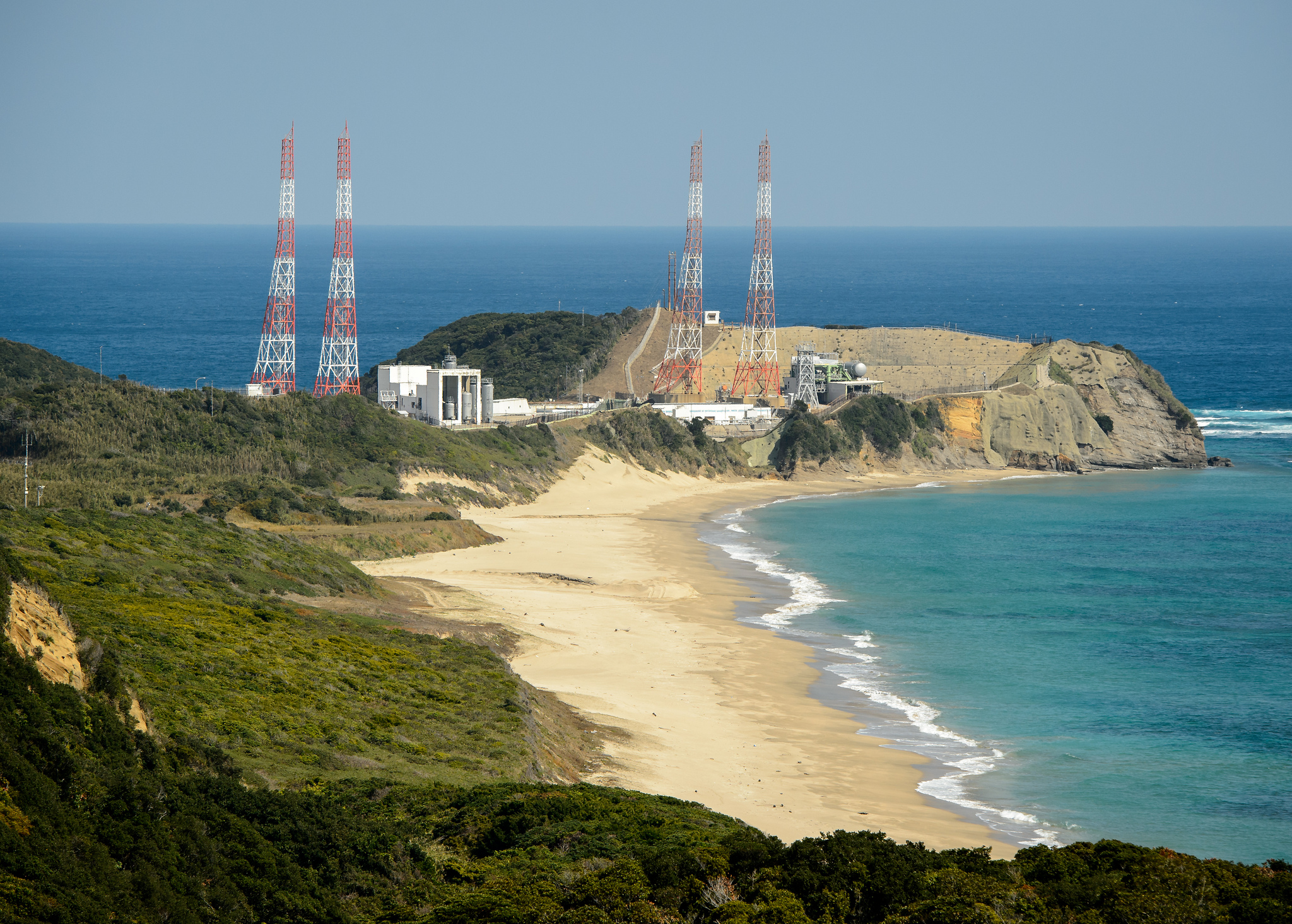
The team is counting down to liftoff in less than 5 days, on Feb. 27 at 1:07 PM EST from the Tanegashima Space Center, on Tanegashima Island off southern Japan, atop the highly reliable Mitsubishi Heavy Industries H-IIA rocket.
The GPM launch to low Earth orbit was delayed by both natural and manmade disasters – namely the 2011 Fukushima earthquake in Japan as well as the ridiculous US government shutdown in Oct. 2013. That’s the same foolish shutdown that also delayed NASA’s new MAVEN Mars orbiter and numerous other US space & science projects.
Visualization of the GPM Core Observatory satellite orbiting the planet earth. Credit: NASA Goddard
The $933 Million mission is a joint venture between NASA and the Japan Aerospace Exploration Agency (JAXA), Japan’s space agency.
The mission will significantly advance our understanding of Earth’s water and energy cycles and improve forecasting of extreme weather events.
It is equipped with an advanced, higher resolution dual -frequency precipitation (DPR) radar instrument (Ku and Ka band) built by JAXA in Japan and the GPM microwave imager (GMI) built by Ball Aerospace in the US.
“The GPM satellite was built in house at NASA’s Goddard Space Flight Center in Maryland,” Art Azarbarzin, GPM project manager, told Universe Today during my exclusive up-close clean room inspection tour of the huge satellite as final processing was underway.
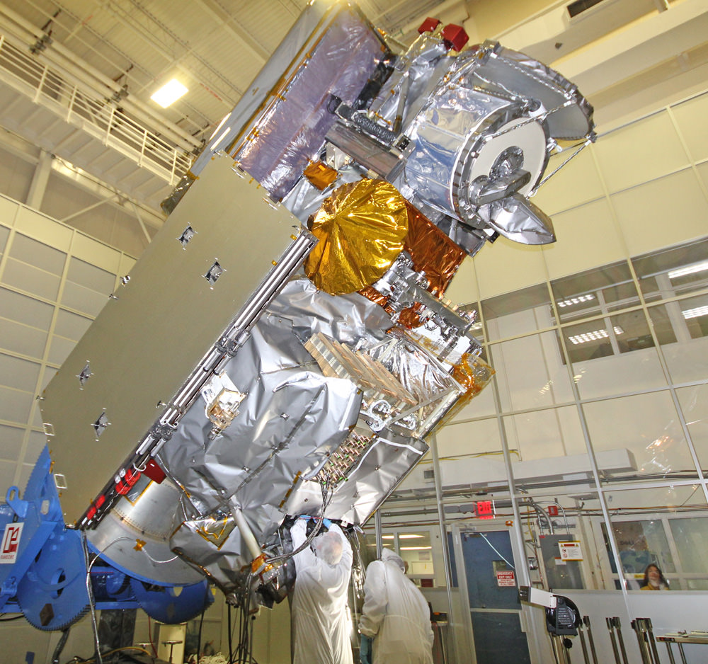
Global Precipitation Measurement (GPM) observatory satellite inside the clean room at NASA Goddard Space Flight Center undergoes final processing – side view. Credit: Ken Kremer/kenkremer.com
Shortly after my tour of GPM, the 3850 kilogram satellite was carefully packed up for shipment to the Japanese launch site.
“GPM will join a worldwide constellation of current and planned satellites,” Azarbarzin told me during an interview in the Goddard cleanroom with GPM.
And the imminent launch to augment the existing satellite constellation can’t come soon enough, he noted.
The GPM observatory will replace the aging NASA/JAXA Tropical Rainfall Measuring Mission (TRMM), satellite launched back in 1997.
“GPM is the direct follow-up to the currently orbiting TRMM satellite,” Azarbarzin explained.
“TRMM is reaching the end of its usable lifetime. GPM launches on February 27, 2014 and we hope it has some overlap with observations from TRMM.”
“The Global Precipitation Measurement (GPM) observatory will provide high resolution global measurements of rain and snow every 3 hours,” Dalia Kirschbaum, GPM research scientist, told me during an interview at Goddard.
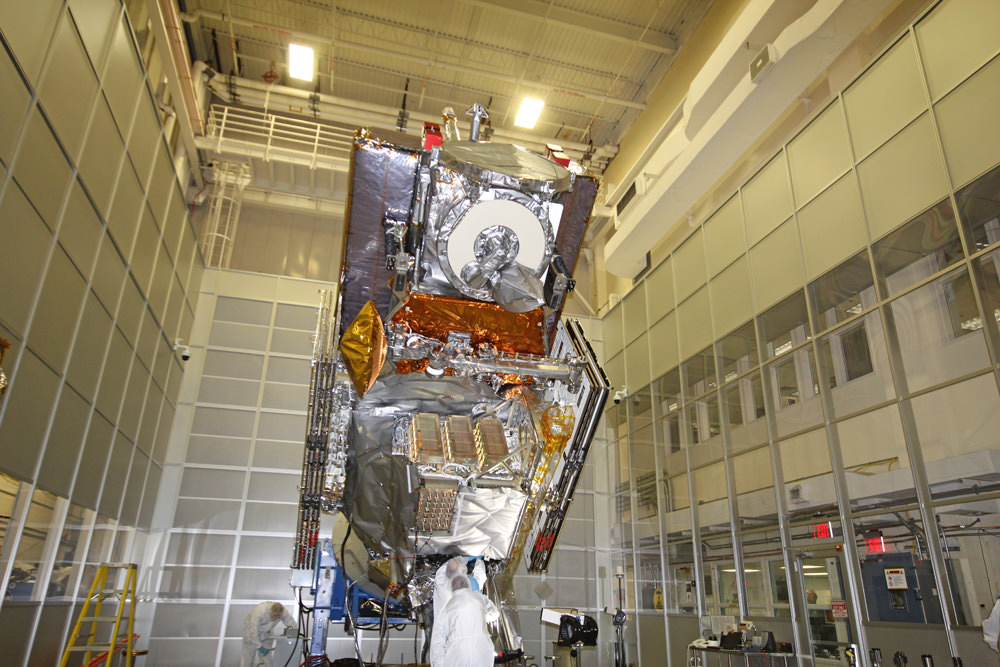
NASA’s next generation Global Precipitation Measurement (GPM) observatory inside the clean room at NASA Goddard Space Flight Center, MD. Technicians at work on final processing during exclusive up-close inspection tour by Universe Today. GPM is slated to launch on February 27, 2014 and will provide global measurements of rain and snow every 3 hours. Credit: Ken Kremer/kenkremer.com
It is vital to continuing the TRMM measurements and will help provide improved forecasts and advance warning of extreme super storms like Hurricane Sandy and Super Typhoon Haiyan, Azarbarzin and Kirschbaum explained.
Researchers will use the GPM measurements to study climate change, freshwater resources, floods and droughts, and hurricane formation and tracking.
“The water-cycle, so familiar to all school-age young scientists, is one of the most interesting, dynamic, and important elements in our studies of the Earth’s weather and climate,” said John Grunsfeld, associate administrator for NASA’s Science Mission Directorate in Washington, in a statement.
“GPM will provide scientists and forecasters critical information to help us understand and cope with future extreme weather events and fresh water resources.”
GPM satellite launch site at Tanegashima Space Center, Tanegashima Island, Japan. Credit: NASA
NASA TV will carry the launch live with commentary starting at 12 Noon EST on Feb. 27.
Stay tuned here for Ken’s continuing GPM reports and onsite coverage at NASA Goddard Space Flight Center in Maryland.
And watch for Ken’s continuing planetary and human spaceflight news about Curiosity, Opportunity, Chang’e-3, SpaceX, Orbital Sciences, LADEE, MAVEN, MOM, Mars, Orion and more.
NASA/JAXA Global Precipitation Measurement (GPM) satellite inside the clean room at NASA Goddard Space Flight Center, MD, undergoes final processing during exclusive up-close inspection tour by Universe Today: Dr. Art Azarbarzin/NASA GPM project manager, Dr. Ken Kremer/Universe Today and Dr. Dalia Kirschbaum/NASA GPM research scientist. Credit: Ken Kremer/kenkremer.com
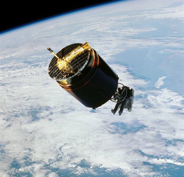
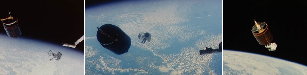
NASA astronaut Dale Gardner captures the malfunctioning WESTAR-VI satellite in 1984. Gardner was using the Manned Maneuvering Unit, a sort of space backpack that was discontinued for astronaut use after the Challenger explosion of 1986. Credit: NASA
I’ll admit it: I’m too young to remember 1984. I wish I did, however, because it was a banner year for the Manned Maneuvering Unit. NASA astronaut Dale Gardner, for example, used this jet backpack to retrieve malfunctioning satellites, as you can see above. (FYI, Gardner died Wednesday (Feb. 19) of a brain aneurysm at the age of 65.)
After three shuttle flights, however, NASA discontinued use of the backpack in space for several reasons — most famously, safety considerations following the shuttle Challenger explosion of 1986. But thirty years on, the problem of dead satellites is growing. There are now thousands of pieces whipping around our planet, occasionally causing collisions and generally causing headaches for people wanting to launch stuff into orbit safely.
Space agencies such as NASA and the European Space Agency have been working hard on reducing debris during launches, but there’s still stuff from decades before. And when a satellite goes dead, if it’s in the wrong orbit it could be circling up there for decades before burning up. How do you fix that?
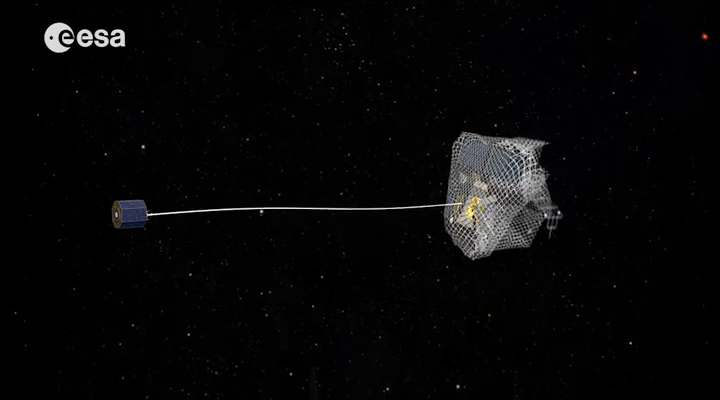
Robotics has come a long way in 30 years, so space agencies are looking to use those instead to pick up derelict satellites since that would pose far less danger to astronauts. One example is the e.DeOrbit mission recently talked about by ESA, which would pick up debris in polar orbits of altitudes between 800 and 1,000 kilometers (about 500 to 620 miles).
One design idea for the e.DeOrbit mission, which would retrieve dead satellites from orbit. Credit: European Space Agency
The mission would use autonomous control and image sensors to get up close to the drifting satellite, and then capture it in some way. Several ideas are being considered, ESA added. A big enough net could easily nab the satellite, or perhaps one could clamp on using tentacles or grab it with a harpoon or robotic arm. Here’s a 2013 proposal with more information on e.DeOrbit. ESA noted there is a symposium coming up May 6 to discuss this in more detail.
e.DeOrbit is one of just several proposals to pick satellites up. A Swiss idea called CleanSpace One appears to use a sort of pincer claw to grab satellites for retrieval. The Phoenix program (proposed by Defense Advanced Research Projects Agency) would take useable parts off of broken satellites for use in new satellites, and in past years DARPA had some ideas to remove satellites from orbit as well. Another option is satellite refueling to make these machines useable again, a possibility that NASA, Canada and many others are taking seriously.
What do you think is the best solution? Leave your thoughts in the comments.
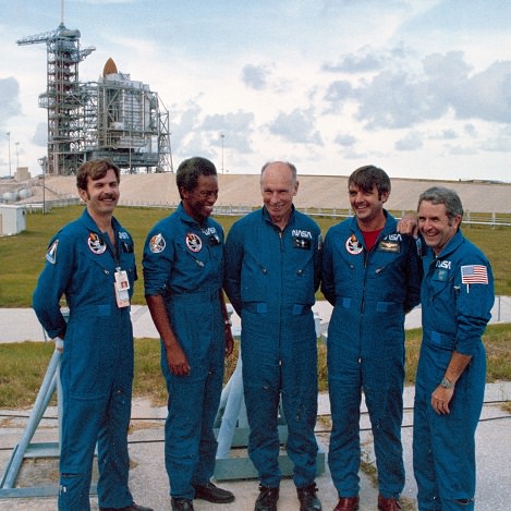
Dale Gardner (left) prior to the launch of STS-8 in 1983, along with the rest of his crew. Moving left, Guy Bluford, Bill Thornton, Daniel Brandenstein and Dick Truly. Credit: NASA
When Dale Gardner smiled for this preflight picture somewhere around 1983, there was another mission on his horizon: picking up a broken satellite … using a jet backpack. And while we believe that all astronauts have an element of derring-do to them, strapping on a device to bring you away from the shuttle’s safety must have taken a special kind of confidence in your equipment.
Gardner, who died Wednesday (Feb. 18) of a brain aneurysm at the age of 65, was one of a handful of astronauts who used the Manned Maneuvering Unit. In his case, it was to retrieve the malfunctioning Westar 6 satellite. Listen to his account of the story (around 9:25 here), however, and you’ll hear a man more focused on favorable sun angles and learning from the experience of another crewmate on STS-51A.
“I essentially just had a lot of fun on Flight Day 7,” he said in the video. And as the sequence of pictures below shows you, technical as the procedure was, the view must have been breathtaking.
Sequence of images showing NASA astronaut Dale Gardner approaching and capturing the malfunctioning Westar 6 satellite in 1984 during STS-51A. Click for a larger version. Credit: NASA (images) / Elizabeth Howell (photo combination)
Gardner, who was born in Minnesota, joined the U.S. Navy after graduating from the University of Illinois in 1970. He earned his wings the following year, then made his way through assignments to the prestigious Naval Air Test Center in Patuxent River, Maryland (the training ground for many future astronauts).
There, he participated in the development and evaluation of the Grumman F-14 Tomcat, an aircraft eventually used in Operation Desert Storm in the 1990s, among many other missions. Gardner was in fact part of the first F-14 squadron from none other than the USS Enterprise (the aircraft carrier, not the Star Trek ship.)
Gardner came to NASA as part of an immense astronaut class in 1978 that was later known as the “Thirty-Five New Guys” (which, it should be noted, also included six women, a first for the agency). With shuttle flights about to begin — a program that was then expected to launch dozens of flights a year — there appeared to be plenty of room for new recruits. Gardner’s first space-based assignment came upon STS-8, which flew in 1983 to deploy an Indian satellite called Insat-1B.
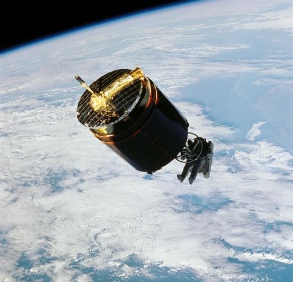
But it was for STS-51A’s eight-day mission in November 1984 where Gardner will be best remembered, because he did this:
NASA astronaut Dale Gardner captures the malfunctioning Westar 6 satellite during STS-51A in 1984. Gardner was using the Manned Maneuvering Unit, a sort of space backpack that was discontinued for astronaut use after the Challenger explosion of 1986. Credit: NASA
The shuttle mission was packed with satellite activity, with crew members deploying the Canadian communications satellite Anik D2, and U.S. defense communications satellite Leasat-1. Then it was time to pick up a couple of broken satellites to haul back to Earth.
Using a sort of grapple tool and his MMU, Joe Allen successfully retrieved Palapa-B2 on Flight Day 5. After Allen told his crewmates that he had some trouble with the sun in his eyes, Gardner used that information on his own MMU trip to pick up Westar 6 two days later. Specifically, Gardner and the crew had him approach in such a way that the shadow of the satellite fell across the astronaut, stopping the sun glare from becoming a problem.
NASA astronaut Dale Gardner holds a “For Sale” sign during STS-51A in 1984, referring to two satellites captured and retrieved on that mission. Credit: NASA
Both satellites had been in improper orbits due to problems with motors, but Gardner and his crew nabbed them safely for a return back to Earth, allowing insurers to resell the satellites for separate launches in 1990. But Gardner had a parting gotcha before handing them back: he held up a “For Sale” sign that you’ve likely seen reprinted somewhere, as it’s among the most famous shots of the shuttle program.
Gardner returned to the Navy in October 1986 (almost a year after the shuttle Challenger explosion), where he joined U.S. Space Command and held several senior positions. He retired from the Navy in 1990 to work in the private sector.
His death this week from a brain aneurysm was said to be sudden, and prompted a Twitter comment from the Association of Space Explorers saying that it was “devastating news.”
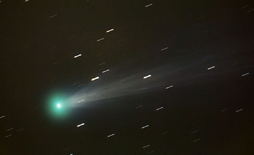
Spectacular photo of Comet ISON taken Nov. 15 from Charleston, Rhode Island, USA showing the recent outburst. Click to enlarge. Credit: Scott MacNeill
Comet ISON — that bright comet last year that broke up around Thanksgiving weekend — included two forms of nitrogen in its icy body, according to newly released observations from the Subaru Telescope.
Of the two types found, the discovery of isotope 15NH2 was the first time it’s ever been seen in a comet. Further, the observations from the Japanese team of astronomers show “there were two distinct reservoirs of nitrogen [in] the massive, dense cloud … from which our Solar System may have formed and evolved,” stated the National Astronomical Observatory of Japan.
Besides being pretty objects to look at, comets are considered valuable astronomical objects because they’re a sort of time capsule of conditions early in the universe. The “fresh” comets are believed to come from a vast area of icy bodies called the Oort Cloud, a spot that has been relatively untouched since the solar system formed about 4.6 billion years ago. Spying elements inside of comets can give clues as to what was present in our neighborhood when the sun and planets were just coming to be.
“Ammonia (NH3) is a particularly important molecule, because it is the most abundant nitrogen-bearing volatile (a substance that vaporizes) in cometary ice and one of the simplest molecules in an amino group (–NH2) closely related to life. This means that these different forms of nitrogen could link the components of interstellar space to life on Earth as we know it,” NAOJ stated.
You can read more details about the finding at the NAOJ website, or in Astrophysical Journal Letters.
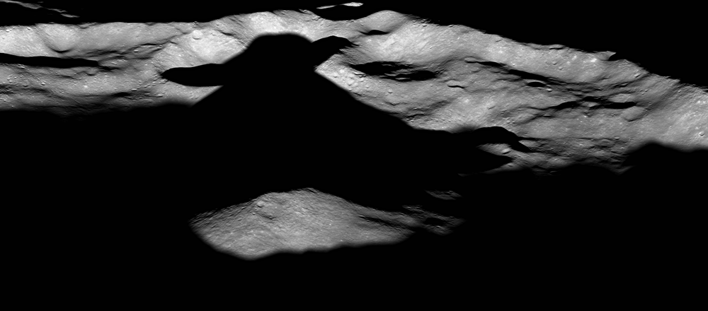
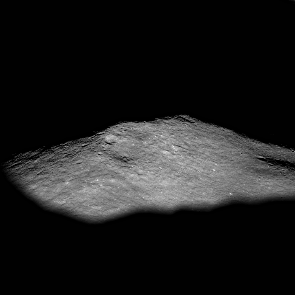
An oblique view from the Lunar Reconnaissance Orbiter of Icarus Crater on the Moon. The shadow created by the unusual central peak in the crater is reminiscent of a certain Star Wars character. Icarus is approximately 94 km in diameter. Credit: NASA/GSFC/Arizona State University.
Scientists from the Lunar Reconnaissance Orbiter say that Icarus Crater is one of a kind on the Moon because its central peak rises higher than about half its rim. Most central peaks rise only about halfway to the crater rim. But at just the ring angle and lighting conditions, the shadow this central peak creates on the rolling and jagged crater rim looks like the Star Wars Character Yoda. Interestingly, this crater is located on what some people erroneously call the “Dark Side” of the Moon – what is actually the lunar farside.
Yoda meditates about moons. Via Blastr.com
Below you can see a closeup of the central peak of Icarus crater rising out of the shadows to greet a new lunar day.
The central peak of Icarus Crater on the Moon’s farside, as seen by LROC. Image width is approximately 10 km, north is to the right. Credit: NASA/GSFC/Arizona State University.
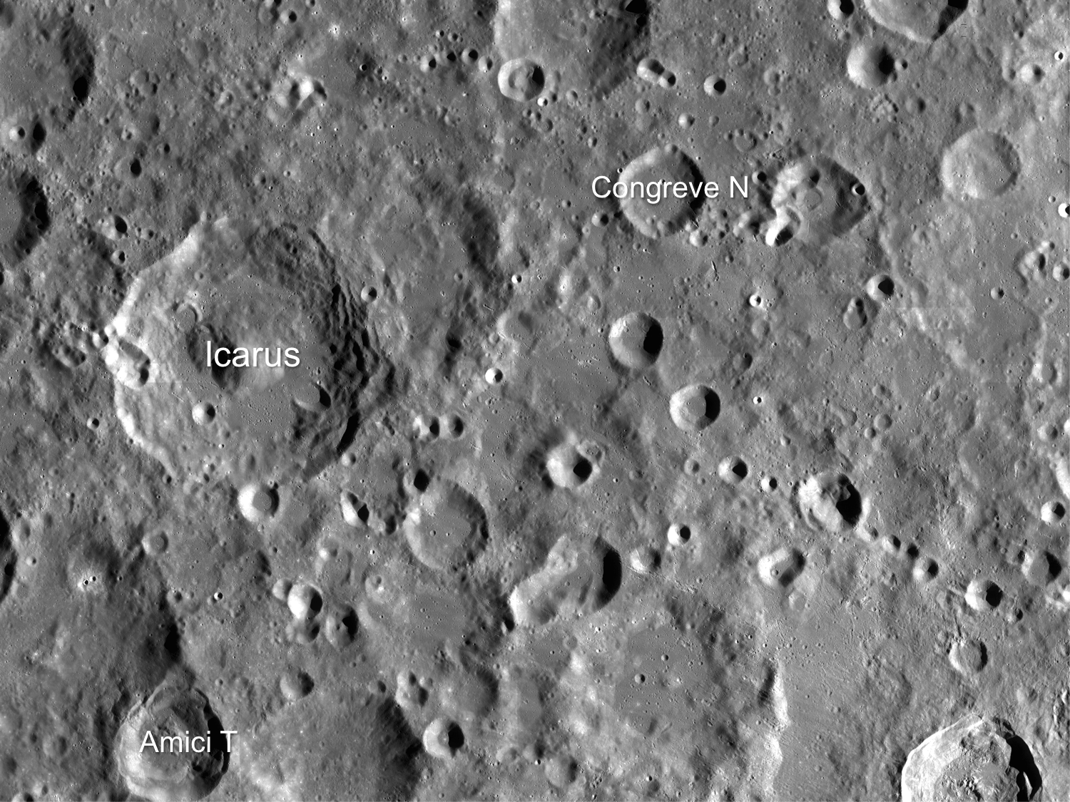
Icarus is located just west of Korolev crater on the lunar farside. The light-colored plains surrounding the craters were deposited during the formation of the Orientale basin, which is located over 1500 km away.
Image from LRO’s Wide Angle Camera of Icarus crater and vicinity. Image width is approximately 365 km. Credit: NASA/GSFC/Arizona State University.
Find out more about these images from LRO and see larger versions at the LROC website.
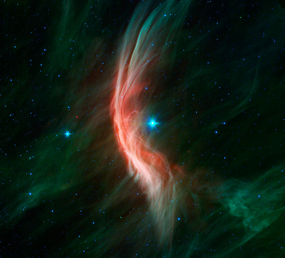
The speeding rogue star Kappa Cassiopeiae sets up a glowing bow shock in this Spitzer image (NASA/JPL-Caltech)
That might seem like a sensational headline worthy of a supermarket tabloid but, taken in context, it’s exactly what’s happening here!
The bright blue star at the center of this image is a B-type supergiant named Kappa Cassiopeiae, 4,000 light-years away. As stars in our galaxy go it’s pretty big — over 57 million kilometers wide, about 41 times the radius of the Sun. But its size isn’t what makes K Cas stand out — it’s the infrared-bright bow shock it’s creating as it speeds past its stellar neighbors at a breakneck 1,100 kilometers per second.
K Cas is what’s called a runway star. It’s traveling very fast in relation to the stars around it, possibly due to the supernova explosion of a previous nearby stellar neighbor or companion, or perhaps kicked into high gear during a close encounter with a massive object like a black hole.
As it speeds through the galaxy it creates a curved bow shock in front of it, like water rising up in front of the bow of a ship. This is the ionized glow of interstellar material compressed and heated by K Cas’ stellar wind. Although it looks like it surrounds the star pretty closely in the image above, the glowing shockwave is actually about 4 light-years out from K Cas… slightly less than the distance from the Sun to Proxima Centauri.
The bow shock of Zeta Ophiuchi, another runaway star observed by Spitzer (NASA/JPL-Caltech)
Although K Cas is visible to the naked eye, its bow shock isn’t. It’s only made apparent in infrared wavelengths, which NASA’s Spitzer Space Telescope is specifically designed to detect. Some other runaway stars have brighter bow shocks — like Zeta Ophiuchi at right — which can be seen in optical wavelengths (as long as they’re not obscured by dust, which Zeta Oph is.)
The bright wisps seen crossing K Cas’ bow shock may be magnetic filaments that run throughout the galaxy, made visible through interaction with the ionized gas. In fact bow shocks are of particular interest to astronomers precisely because they help reveal otherwise invisible features and allow deeper investigation into the chemical composition of stars and the regions of the galaxy they are traveling through. Like a speeding car on a dark country road, runaway stars’ bow shocks are — to scientists — like high-beam headlamps lighting up the space ahead.
Runaway stars are not to be confused with rogue stars, which, although also feel the need for speed, have been flung completely out of their home galaxies.
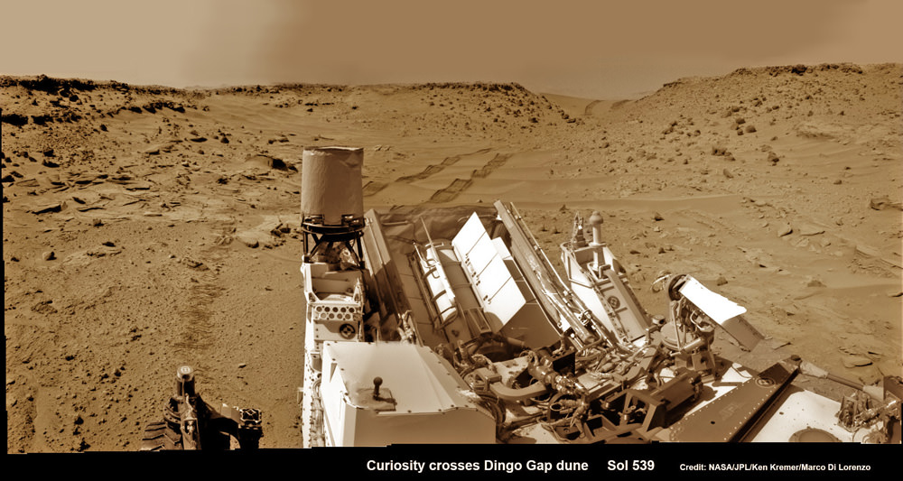
Curiosity looks back eastward to ‘Dingo Gap’ sand dune inside Gale Crater. After crossing over the 3 foot (1 meter) tall dune on Sol 539, Feb. 9, 2014 the rover drove westward into the ‘Moonlight Valley’. The parallel rover wheel tracks are 9 feet (2.7 meters) apart. Assembled from Sol 539 colorized navcam raw images. Credit: NASA/JPL/ Ken Kremer- kenkremer.com/Marco Di Lorenzo
Curiosity looks back eastward to ‘Dingo Gap’ sand dune inside Gale Crater
After crossing over the 3 foot (1 meter) tall dune on Sol 539, Feb. 9, 2014 the rover drove westward into the ‘Moonlight Valley’. The parallel rover wheel tracks are 9 feet (2.7 meters) apart. Assembled from Sol 539 colorized navcam raw images. Credit: NASA/JPL/ Ken Kremer- kenkremer.com/Marco Di Lorenzo
See Dune and Wheel mosaics below – Story updated [/caption]
The team directing the epic trek of NASA’s Curiosity rover across the floor of Gale Crater has adopted new driving strategies and a new way forward in response to the unexpected wheel damage caused by driving over fields of rough edged Red Planet rocks in recent months.
This week, engineers directed dune buggy Curiosity to drive backwards for a lengthy distance over the Martian surface for the first time since landing.
The SUV sized vehicle apparently passed the reverse driving feasibility test with flying colors and is now well on the way to the exciting journey ahead aiming for the sedimentary layers at the base of towering Mount Sharp – the primary mission destination – which reaches 3.4 miles (5.5 km) into the Martian sky and possesses water altered minerals.
“We wanted to have backwards driving in our validated toolkit because there will be parts of our route that will be more challenging,” said Curiosity Project Manager Jim Erickson of NASA’s Jet Propulsion Laboratory, Pasadena, Calif, in a statement.
On Tuesday, Feb. 18, Curiosity not only drove in reverse, but the 329 feet (100.3 meters) distance covered marked her farthest one-day advance in over three months.
And she is also now roving over the much sought after smoother Martian terrain, as hoped, when the team decided to alter the traverse route based on high resolution imaging observations collected by the telescopic camera on NASA’s Mars Reconnaissance Orbiter (MRO) circling overhead.
The goal is to minimize wear and tear on the 20 inch diameter wheels.
This map shows the route driven and route planned for NASA’s Curiosity Mars rover from before reaching “Dingo Gap” — in upper right — to the mission’s next science waypoint, “Kimberley” (formerly referred to as “KMS-9”) — in lower left. Credit: NASA/JPL-Caltech/Univ. of Arizona
Engineers were forced to devise new driving techniques and consider a new route forward after the aluminum wheels accumulated significant punctures and rips during the past few months of driving over fields strewn with sharp edged Martian rocks.
“We have changed our focus to look at the big picture for getting to the slopes of Mount Sharp, assessing different potential routes and different entry points to the destination area,” Erickson said.
“No route will be perfect; we need to figure out the best of the imperfect ones.”
But to reach the smooth terrain and the science rich targets located on the pathway ahead, the six wheeled rover first had to pass through a gateway known as the ‘Dingo Gap’ sand dune.
Curiosity’s View Past Tall Dune at edge of ‘Dingo Gap’
This photomosaic from Curiosity’s Navigation Camera (Navcam) taken at the edge of the entrance to the Dingo Gap shows a 3 foot (1 meter) tall dune and valley terrain beyond to the west, all dramatically back dropped by eroded rim of Gale Crater. View from the rover’s current position on Sol 528 (Jan. 30, 2014). The rover team may decide soon whether Curiosity will bridge the dune gap as a smoother path to next science destination. Credit: NASA/JPL-Caltech/Marco Di Lorenzo/Ken Kremer- kenkremer.com
“Moonlight Valley” is the name of the breathtaking new locale beyond Dingo, Curiosity Principal Investigator John Grotzinger, of Caltech, told Universe Today.
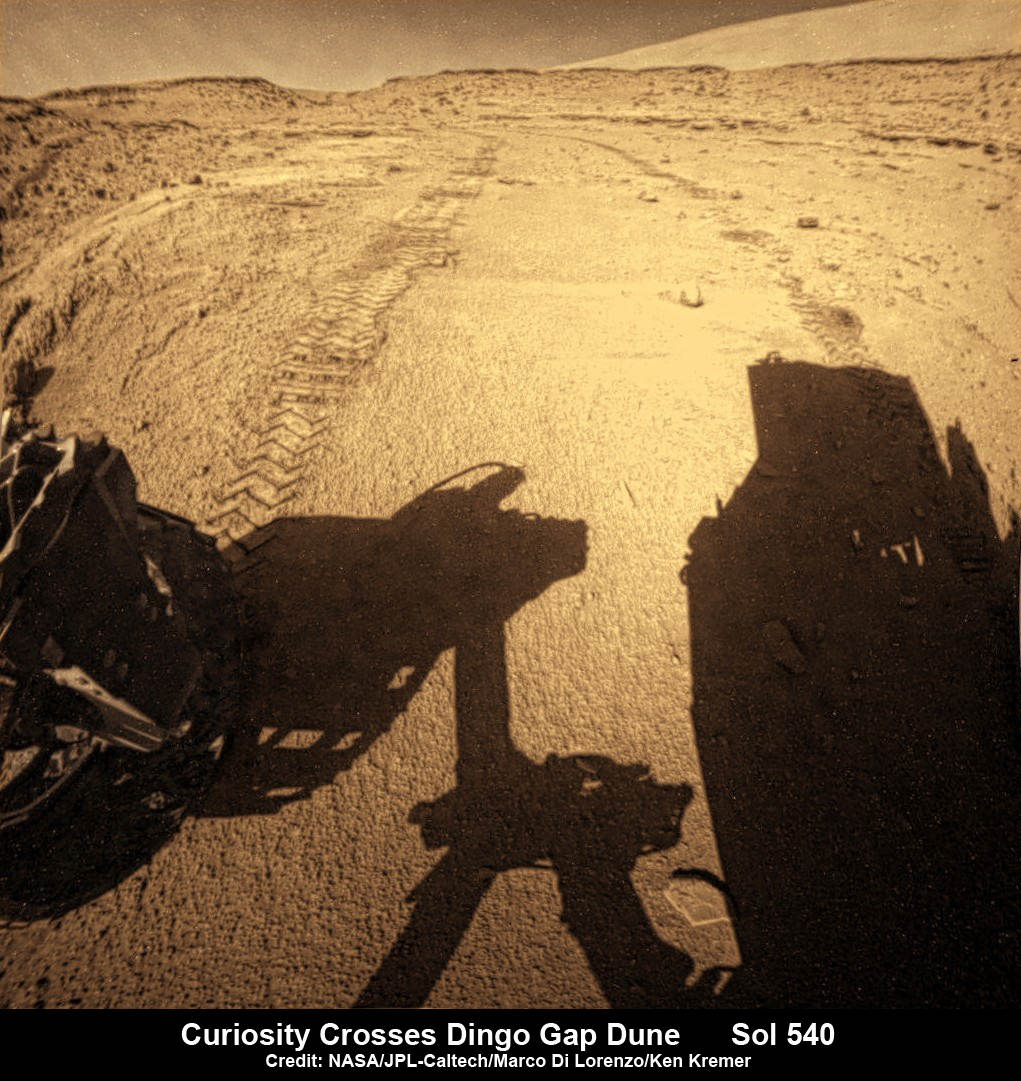
Curiosity crossed through the 3 foot (1 meter) tall Dingo Gap sand dune with ease on Feb. 9 and roved on to targets in the “Moonlight Valley” and the region beyond.
“Moonlight Valley has got lots of veins cutting through it,” Grotzinger told me.
“We’re seeing recessive bedrock.”
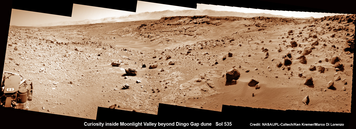
Curiosity scans Moonlight Valley beyond Dingo Gap Dune. Curiosity’s view to “Moonlight Valley” beyond after crossing over ‘Dingo Gap’ sand dune. This photomosaic was taken after Curiosity drove over the 1 meter tall Dingo Gap sand dune and shows dramatic scenery in the valley beyond, back dropped by eroded rim of Gale Crater. Assembled from navigation camera (navcam) raw images from Sol 535 (Feb. 6, 2104) Credit: NASA/JPL-Caltech/Ken Kremer- kenkremer.com/Marco Di Lorenzo
Since passing through the Dingo Gap gateway, Curiosity has traveled another 937 feet (285.5 meters) for a total mission odometry of 3.24 miles (5.21 kilometers) since the nail biting landing on Aug. 6, 2012.
“After we got over the dune, we began driving in terrain that looks like what we expected based on the orbital data. There are fewer sharp rocks, many of them are loose, and in most places there’s a little bit of sand cushioning the vehicle,” Erickson said.
Curiosity looks back to ‘Dingo Gap’ sand dune after crossing over, backdropped by Mount Sharp on Sol 540, Feb. 12, 2014. Rear hazcam fisheye image linearized and colorized. Credit: NASA/JPL/Marco Di Lorenzo/Ken Kremer- kenkremer.com
Curiosity’s near term goal is to reach her next science waypoint, named Kimberly (formerly called KMS-9) which lies about two-thirds of a mile (about 1.1 kilometers) ahead.
Kimberly is of interest to the science team because it sits at an the intersection of different rock layers.
The 1 ton robot may be directed to drill into another rock at Kimberly.
If approved, Kimberly would be her first since drilling operation since boring into Cumberland rock target last spring and since departing the Yellowknife Bay region in July 2013 where she discovered a habitable zone.
Curiosity looks back to ‘Dingo Gap’ sand dune after crossing over, backdropped by Mount Sharp on Sol 535, Feb. 5, 2014. Hazcam fisheye image linearized and colorized. Credit: NASA/JPL/Marco Di Lorenzo/Ken Kremer- kenkremer
To date Curiosity’s odometer stands at 5.2 kilometers and she has taken over 118,000 images. The robot has about another 5 km to go to reach the foothills of Mount Sharp.
Stay tuned here for Ken’s continuing Curiosity, Opportunity, Chang’e-3, SpaceX, Orbital Sciences, LADEE, MAVEN, MOM, Mars and more planetary and human spaceflight news.
Up close photomosaic view shows lengthy tear in rover Curiosity’s left front wheel caused by recent driving over sharp edged Martian rocks on the months long trek to Mount Sharp. Raw images taken by the MAHLI camera on Curiosity’s arm on Jan. 31, 2014 (Sol 529) were assembled to show some recent damage to several of its six wheels Credit: NASA / JPL / MSSS / Marco Di Lorenzo / Ken Kremer- kenkremer.com
Since we started Universe Today almost 15 years ago, we’ve been entirely supported by advertising (and my savings). But now there’s an exciting new service called Patreon which allows fans to directly support the projects they love.
And if you’re a regular reader of Universe Today, you know we’ve got tens of thousands of articles, and a steady stream of podcasts, videos, graphics and interactive applications. We’ve got a pretty big team of writers and this stuff is expensive.
If you’re a serious fan of Universe Today, consider joining our Patreon community. You’ll get:
All the advertising removed from the website.
Early access to our upcoming videos.
Exclusive access to our full-length raw video interviews.