100 Days of MOM – India’s 1st Mars Mission Streaking to Red Planet Rendezvous

India’s Mars Orbiter Mission (MOM) completes 100 days in space on February 12, 2014 on its journey to reach the Red Planet on Sept 24, 2014. Credit ISRO

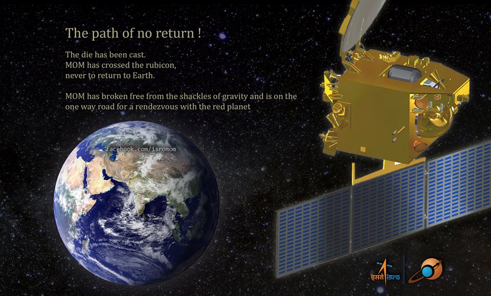
India’s maiden Mars explorer, the Mars Orbiter Mission or MOM, celebrated 100 days speeding through space this past week, racing outwards on its historic journey to the Red Planet.

After streaking through space for some ten and a half months, the 1,350 kilogram (2,980 pound) MOM probe will rendezvous with the Red Planet on September 24, 2014 – where she will study the atmosphere and sniff for signals of methane.

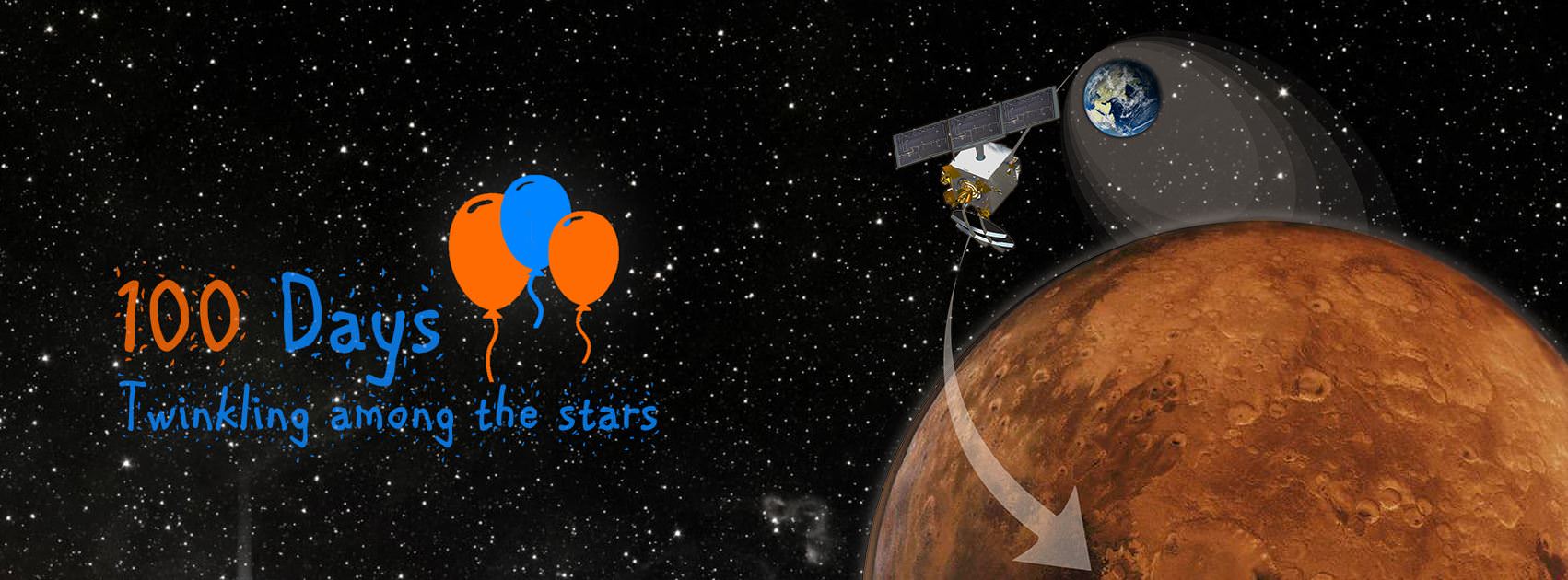
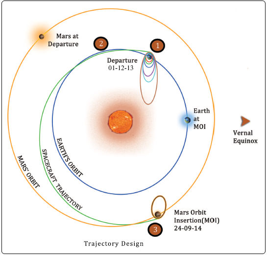
Feb. 12, 2014 marked ‘100 Days of MOM’ since the picture perfect blast off on Nov. 5, 2013 from India’s spaceport at the Satish Dhawan Space Centre, Sriharikota, atop the nations indigenous Polar Satellite Launch Vehicle (PSLV) which placed the probe into its initial Earth parking orbit.

First ever image of Earth Taken by Mars Color Camera aboard India’s Mars Orbiter Mission (MOM) spacecraft while orbiting Earth and before the Trans Mars Insertion firing on Dec. 1, 2013. Image is focused on the Indian subcontinent.  Credit: ISRO
First ever image of Earth Taken by Mars Color Camera aboard India’s Mars Orbiter Mission (MOM) spacecraft while orbiting Earth and before the Trans Mars Insertion firing on Dec. 1, 2013. Image is focused on the Indian subcontinent. Credit: ISRO

A series of six subsequent orbit raising maneuvers ultimately culminated with the liquid fueled main engine firing on Dec. 1, 2013 for the Trans Mars Injection(TMI) maneuver that successfully placed MOM on a heliocentric elliptical trajectory to the Red Planet.

The TMI, affectionately dubbed ‘The mother of all slingshots’ finally provided the craft with sufficient thrust to achieve escape velocity and blast free of the Earth’s sphere of influence forever and begin her nearly yearlong momentous voyage to Mars.

The first of four in flight Trajectory Correction Maneuvers, TCM-1, was conducted by firing the 22 Newton Thrusters for a duration of 40.5 seconds on December 11, 2013. A trio of additional TCM firings are planned around April 2014, August 2014 and September 2014.

Trans Mars Injection (TMI), carried out on Dec 01, 2013 at 00:49 hrs (IST) has moved the spacecraft in the Mars Transfer Trajectory (MTT). With TMI the Earth orbiting phase of the spacecraft ended and the spacecraft is now on a course to encounter Mars after a journey of about 10 months around the Sun. Credit: ISRO

MOM was designed and developed by the Indian Space Research Organization’s (ISRO) at a cost of $69 Million and marks India’s inaugural foray into interplanetary flight.

During the first 100 days, the probe has traveled about 190 million kilometers and has a little less than 500 million kilometers and 205 days to go during her journey of some 680 million kilometers (400 million miles) overall.

A health check on February 6, 2014 confirmed that the 15 kg (33 lb) science payload comprising five Indian built instruments was turned “ON” and is operating well.

MOM is currently some 16 million km distant from Earth and one way radio signals take approximately 55 seconds.

“The round trip time is almost 2 minutes for a communication signal to go to MOM and come back, about the same time mom takes to make noodles!” ISRO noted humorously in a Facebook mission posting.

“Keep going MOM!”

MOM's first Trajectory Correction Manoeuver in Baiju Raj's imagination.
MOM’s first Trajectory Correction Manoeuver in Baiju Raj’s imagination.

Following the ten month cruise through space the orbital insertion engine will fire for the do or die burn on September 24, 2014 placing MOM into an 377 km x 80,000 km elliptical orbit around Mars.

MOM is not alone in the frigid vacuum of space. She is joined by NASA’s MAVEN orbiter in pursuit of Mars.

MOM will reach Mars vicinity just two days after the arrival MAVEN on Sept. 22, 2014.

To date MAVEN has flown over 137 million miles (221 million km) of its total 442 million miles (712 million km) path to Mars.

If all continues to goes well, India will join an elite club of only four who have launched probes that successfully investigated the Red Planet from orbit or the surface – following the Soviet Union, the United States and the European Space Agency (ESA).

Both MAVEN and MOM’s goal is to study the Martian atmosphere, unlock the mysteries of its current atmosphere and determine how, why and when the atmosphere and liquid water was lost – and how this transformed Mars climate into its cold, desiccated state of today.

Together, MOM and MAVEN will fortify Earth’s invasion fleet at Mars. They join 3 current orbiters from NASA and ESA as well as NASA’s pair of sister surface roversCuriosity and Opportunity.

Although they were developed independently and have different suites of scientific instruments, the MAVEN and MOM science teams will “work together” to unlock the secrets of Mars atmosphere and climate history, MAVEN’s top scientist told Universe Today.

“We have had some discussions with their science team, and there are some overlapping objectives,” Bruce Jakosky told me. Jakosky is MAVEN’s principal Investigator from the University of Colorado at Boulder.

“At the point where we [MAVEN and MOM] are both in orbit collecting data we do plan to collaborate and work together with the data jointly,” Jakosky said.

Stay tuned here for Ken’s continuing MOM, Opportunity, Curiosity, Chang’e-3, LADEE, MAVEN, Mars rover and more planetary and human spaceflight news.

Ken Kremer

1452418_1402640509973889_477104420_n

NOvA Experiment Nabs Its First Neutrinos

The NUmI (Neutrinos from the Main Injector) horn at Fermilab, which fires protons that degrade into neutrinos. (Image: Caltech)

Neutrinos are some of the most abundant, curious, and elusive critters in particle physics. Incredibly lightweight — nigh massless, according to the Standard Model — as well as chargeless, they zip around the Universe at the speed of light and they don’t interact with any other particles. Some of them have been around since the Big Bang and, just as you’ve read this, trillions of them have passed through your body (and more are on the way.) But despite their ubiquitousness neutrinos are notoriously difficult to study precisely because they ignore pretty much everything made out of anything else. So it’s not surprising that weighing a neutrino isn’t as simple as politely asking one to step on a scale.

Thankfully particle physicists are a tenacious lot, including the ones at the U.S. Department of Energy’s Fermilab, and they aren’t giving up on their latest neutrino safari: the NuMI Off-Axis Electron Neutrino Appearance experiment, or NOvA. (Scientists represent neutrinos with the Greek letter nu, or v.) It’s a very small-game hunt to catch neutrinos on the fly, and it uses some very big equipment to do the job. And it’s already captured its first neutrinos — even before their setup is fully complete.

Created by smashing protons against graphite targets in Fermilab’s facility just outside Chicago, Illinois, resulting neutrinos are collected and shot out in a beam 500 miles northwest to the NOvA far detector in Ash River, Minnesota, located along the Canadian border. The very first beams were fired in Sept. 2013, while the Ash River facility was still under construction.

One of the first detections by NOvA of Fermilab-made neutrinos (Image courtesy of NOvA collaboration)

“That the first neutrinos have been detected even before the NOvA far detector installation is complete is a real tribute to everyone involved,” said University of Minnesota physicist Marvin Marshak, Ash River Laboratory director. “This early result suggests that the NOvA collaboration will make important contributions to our knowledge of these particles in the not so distant future.”

The 500-mile (800 km) path of the NOvA neutrino beam (Fermilab)
The 500-mile (800 km) subterranean path of the NOvA neutrino beam (Fermilab)

The beams from Fermilab are fired in two-second intervals, each sending billions of neutrinos directly toward the detectors. The near detector at Fermilab confirms the initial “flavor” of neutrinos in the beam, and the much larger far detector then determines if the neutrinos have changed during their three-millisecond underground interstate journey.

Again, because neutrinos don’t readily interact with ordinary particles, the beams can easily travel straight through the ground between the facilities — despite the curvature of the Earth. In fact the beam, which starts out 150 feet (45 meters) below ground near Chicago, eventually passes over 6 miles (10 km) deep during its trip.

According to a press release from Fermilab, neutrinos “come in three types, called flavors (electron, muon, or tau), and change between them as they travel. The two detectors of the NOvA experiment are placed so far apart to give the neutrinos the time to oscillate from one flavor to another while traveling at nearly the speed of light. Even though only a fraction of the experiment’s larger detector, called the far detector, is fully built, filled with scintillator and wired with electronics at this point, the experiment has already used it to record signals from its first neutrinos.”

The 50-foot (15 m) tall detector blocks are filled with a liquid scintillator that’s made of 95% mineral oil and 5% liquid hydrocarbon called pseudocumene, which is toxic but “imperative to the neutrino-detecting process.”  The mixture magnifies any light that hits it, allowing the neutrino strikes to be more easily detected and measured. (Source)

“NOvA represents a new generation of neutrino experiments,” said Fermilab Director Nigel Lockyer. “We are proud to reach this important milestone on our way to learning more about these fundamental particles.”

One of NOvA's 28 detectors  (Fermilab)
One of NOvA’s 28 far detector blocks (Fermilab)

After completion this summer NOvA’s near and far detectors will weigh 300 and 14,000 tons, respectively.

The goal of the NOvA experiment is to successfully capture and measure the masses of the different neutrino flavors and also determine if neutrinos are their own antiparticles (they could be the same, since they lack  specific charge.) By comparing the oscillations (i.e., flavor changes) of muon neutrino beams vs. muon antineutrino beams fired from Fermilab, scientists hope to determine their mass hierarchy — and ultimately discover why the Universe currently contains much more matter than antimatter.

Read more: Neutrino Detection Could Help Paint an Entirely New Picture of the Universe

Once the experiment is fully operational scientists expect to catch a precious few neutrinos every day — about 5,000 total over the course of its six-year run. Until then, they at least now have their first few on the books.

“Seeing neutrinos in the first modules of the detector in Minnesota is a major milestone. Now we can start doing physics.”
– Rick Tesarek, Fermilab physicist

Learn more about the development and construction of the NoVA experiment below:


(Video credit: Fermilab)

Find out more about the NOvA research goals here.

Source: Fermilab press release

The NOvA collaboration is made up of 208 scientists from 38 institutions in the United States, Brazil, the Czech Republic, Greece, India, Russia and the United Kingdom. The experiment receives funding from the U.S. Department of Energy, the National Science Foundation and other funding agencies.

Mystery of the Martian ‘Jelly Doughnut’ Rock – Solved

This image from the panoramic camera (Pancam) on NASA’s rover Opportunity shows the location of a rock called "Pinnacle Island" before it appeared in front of the rover in early January 2014. Arrow at lower left. This image was taken during Sol 3567 of Opportunity's work on Mars (Feb. 4, 2014). Credit: NASA/JPL-Caltech/Cornell Univ./Arizona State Univ.

The mystery of the world famous “Jelly Doughnut” rock on Mars has at last been solved by diligent mission scientists toiling away in dank research labs on Earth.

The “Jelly Doughnut” rock achieved worldwide fame, or better yet infamy, when it suddenly appeared out of nowhere in pictures taken by NASA’s renowned Red Planet rover Opportunity in January.

And the answer is – well it’s not heretofore undetected Martian beings or even rocks falling from the sky.

Rather its ‘Alien Space Invaders’ – in some sense at least.

And that ‘Alien Space Invader’ is from – Earth! And her name is – Opportunity!

Indeed sister rover Curiosity may have unwittingly pointed to the culprit and helped resolve the riddle when she snapped a brand new photo of Earth – home planet to Opportunity and Curiosity and all their makers! See the evidence for yourselves – lurking here!

It turns out that the six wheeled Opportunity unknowingly ‘created’ the mystery herself when she drove over a larger rock, crushing it with the force from the wheels and her 400 pound (185 kg) mass.

Fragments were sent hurtling across the summit of the north facing Solander Point mountain top, where she is currently climbing up ‘Murray Ridge’ along the western rim of a vast crater named Endeavour that spans some 22 kilometers (14 miles) in diameter. See traverse map below.

One piece unwittingly rolled downhill.

That rock fragment – now dubbed ‘Pinnacle Island’ – suddenly appeared in pictures taken by Opportunity’s cameras on Jan, 8, 2014 (Sol 3540).

Mosaic of Opportunity and mysterious Pinnacle Island rock by Solander Point peak.  Mysterious Pinnacle Island rock suddenly appeared out of nowhere in images snapped on Sol 3540.  It was absent in earlier images on Sol 3528.  This mosaic shows the rock nearby the solar panels of NASA’s Opportunity rover.  Assembled from Sol 3528 and 3540 pancam raw images.  Credit: NASA/JPL/Cornell/Marco Di Lorenzo/Ken Kremer-kenkremer.com
Mosaic of Opportunity and mysterious Pinnacle Island rock by Solander Point peak. Mysterious Pinnacle Island rock suddenly appeared out of nowhere in images snapped on Sol 3540. It was absent in earlier images on Sol 3528. This mosaic shows the rock nearby the solar panels of NASA’s Opportunity rover. Assembled from Sol 3528 and 3540 pancam raw images. Credit: NASA/JPL/Cornell/Marco Di Lorenzo/Ken Kremer-kenkremer.com

And that exact same spot had been vacant of debris in photos taken barely 4 days earlier – during which time the rover didn’t move a single millimeter.

Pinnacle Island measures only about 1.5 inches wide (4 centimeters) with a noticeable white rim and red center – hence its jelly doughnut nickname.

The Martian riddle was finally resolved when Opportunity roved a tiny stretch and took some look back photographs to document the ‘mysterious scene’ for further scrutiny.

“Once we moved Opportunity a short distance, after inspecting Pinnacle Island, we could see directly uphill an overturned rock that has the same unusual appearance,” said Opportunity Deputy Principal Investigator Ray Arvidson of Washington University in St. Louis, in a NASA statement.

“We drove over it. We can see the track. That’s where Pinnacle Island came from.”

New pictures showed another fragment of the rock – dubbed ‘Stuart Island’ – eerily similar in appearance to the ‘Pinnacle Island’ doughnut.

Opportunity by Solander Point peak – 2nd Mars Decade Starts here!  NASA’s Opportunity rover captured this panoramic mosaic on Dec. 10, 2013 (Sol 3512) near the summit of “Solander Point” on the western rim of Endeavour Crater where she starts Decade 2 on the Red Planet. She is currently investigating outcrops of potential clay minerals formed in liquid water on her 1st mountain climbing adventure. Assembled from Sol 3512 navcam raw images. Credit: NASA/JPL/Cornell/Marco Di Lorenzo/Ken Kremer-kenkremer.com
Opportunity by Solander Point peak – 2nd Mars Decade Starts here! NASA’s Opportunity rover captured this panoramic mosaic on Dec. 10, 2013 (Sol 3512) near the summit of “Solander Point” on the western rim of Endeavour Crater where she starts Decade 2 on the Red Planet. She is currently investigating outcrops of potential clay minerals formed in liquid water on her 1st mountain climbing adventure. Assembled from Sol 3512 navcam raw images. Credit: NASA/JPL/Cornell/Marco Di Lorenzo/Ken Kremer-kenkremer.com

To gather some up-close clues before driving away, the rover deployed its robotic arm to investigate ‘Pinnacle Island’ with her microscopic imager and APXS mineral mapping spectrometer.

The results revealed high levels of the elements manganese and sulfur “suggesting these water-soluble ingredients were concentrated in the rock by the action of water,” says NASA.

“This may have happened just beneath the surface relatively recently,” Arvidson noted, “or it may have happened deeper below ground longer ago and then, by serendipity, erosion stripped away material above it and made it accessible to our wheels.”

This before-and-after pair of images of the same patch of ground in front of NASA's Mars Exploration Rover Opportunity 13 days apart documents the arrival of a bright rock onto the scene.  Credit: NASA/JPL-Caltech/Cornell Univ./Arizona State Univ.
This before-and-after pair of images of the same patch of ground in front of NASA’s Mars Exploration Rover Opportunity 13 days apart documents the arrival of a bright rock onto the scene. Credit: NASA/JPL-Caltech/Cornell Univ./Arizona State Univ.

The Solander Point mountaintop is riven with outcrops of minerals, including clay minerals, that likely formed in flowing liquid neutral water conducive to life – potentially a scientific goldmine.

Opportunity
is NASA’s 1st ever ‘Decade Old’ living Mars rover.

She has been uncovering and solving Mars’ billion years old secrets for over 10 years now since landing back on January 24, 2004 on Meridiani Planum – although she was only expected to function a mere 90 days!

Today, Feb 15, marks Opportunity’s 3578th Sol or Martian Day roving Mars.

So far she has snapped over 188,700 amazing images on the first overland expedition across the Red Planet.

Her total odometry stands at over 24.07 miles (38.73 kilometers) since touchdown on Jan. 24, 2004 at Meridiani Planum.

Read more about sister Spirit – here and here.

Meanwhile on the opposite side of Mars, Opportunity’s younger sister rover Curiosity is trekking towards gigantic Mount Sharp and just crested over the Dingo Gap sand dune. She celebrated 500 Sols on Mars on New Years Day 2014.

And a pair of new orbiters are streaking to the Red Planet to fortify Earth’s invasion fleet- NASA’s MAVEN and India’s MOM.

Finally, China’s Yutu rover has awoken for her 3rd workday on the Moon.

Stay tuned here for Ken’s continuing Opportunity, Curiosity, Chang’e-3, LADEE, MAVEN, Mars rover, MOM and continuing planetary and human spaceflight news.

Ken Kremer

Traverse Map for NASA’s Opportunity rover from 2004 to 2014  This map shows the entire path the rover has driven during a decade on Mars and over 3560 Sols, or Martian days, since landing inside Eagle Crater on Jan 24, 2004 to current location by Solander Point summit at the western rim of Endeavour Crater. Rover will spend 6th winter here atop Solander. Opportunity discovered clay minerals at Esperance – indicative of a habitable zone. Credit: NASA/JPL/Cornell/ASU/Marco Di Lorenzo/Ken Kremer – kenkremer.com
Traverse Map for NASA’s Opportunity rover from 2004 to 2014
This map shows the entire path the rover has driven during a decade on Mars and over 3560 Sols, or Martian days, since landing inside Eagle Crater on Jan 24, 2004 to current location by Solander Point summit at the western rim of Endeavour Crater. Rover will spend 6th winter here atop Solander. Opportunity discovered clay minerals at Esperance – indicative of a habitable zone. Credit: NASA/JPL/Cornell/ASU/Marco Di Lorenzo/Ken Kremer – kenkremer.com

Happy 1st Anniversary Chelyabinsk! The Fireball that Woke Up the World

Chelyabinsk fireball recorded by a dashcam from Kamensk-Uralsky north of Chelyabinsk where it was still dawn. A study of the area near this meteor air burst revealed similar signatures to the Tall el_Hammam site.

Wonder and terror. Every time I watch the dashcam videos of the Chelyabinsk fireball it sends chills down my spine. One year ago today, February 15, 2013, the good citizens of Chelyabinsk, Russia and surrounding towns collectively experienced these two powerful emotions as they witnessed the largest meteorite fall in over 100 years. 


Incredible compilation of dashcam and security camera videos of the fireball

The Chelyabinsk fall, the largest witnessed meteorite fall since the Tunguska event in 1908, exploded with 20-30 times the force of the atomic bomb over Hiroshima at an altitude of just 14.5 miles (23 km). Before it detonated into thousands of mostly gravel-sized meteorites and dust,  it’s estimate the incoming meteoroid was some 66 feet (20-meters) end to end, as tall as a five-story building. The shock wave from the explosion shattered windows up and down the city, injuring nearly 1,500 people.

Friction and enormous pressures placed upon the Chelyabinsk meteoroid by the atmosphere caused it to explode to pieces and send a shock wave across the cities below. This is a selection of typical small, fusion-crust covered Chelyabinsk meteorites. The U.S. penny is 9mm in diameter. Credit: Bob King
Atmospheric friction pressure on the Chelyabinsk meteoroid caused it to explode to pieces and send a shock wave across the land below. Pictured is a selection of typical small, fusion-crust covered Chelyabinsk meteorites recovered shortly after the fall. The U.S. penny is 9mm in diameter. Credit: Bob King

For nearby observers it briefly appeared brighter than the sun.  NASA Meteorite researcher Peter Jenniskens conducted an Internet survey of eyewitnesses and found that eye pain and temporary blindness were the most common complaints from those who looked directly at the fireball.  20 people also reported sunburns including one person burned so badly that his skin peeled:

Trajectory projection and strewnfield map showing the main fireball (and two additional explosions) at top and the elliptical shaped area where the densest concentration of meteorites were found. Credit: Svend  Buhl and K. Wimmer
Map showing the trajectory of the main fireball in yellow (and two additional explosions at top left). The pink oval, called the strewnfield, is where the densest concentration of meteorites were found. Click to see additional maps. Credit: Svend Buhl and K. Wimmer

“We calculated how much UV light came down and we think it’s possible,” Jenniskens said. Perhaps surprisingly, most of the meteoroid’s mass – an estimated 76% – burned up and was converted to dust during atmospheric entry. It’s estimated that only 0.05% of the original meteoroid or 9,000 to 13,000 pounds of meteorites fell to the ground.


No video I’ve seen better captures the both the explosion of the fireball and ensuring confusion and chaos better than this one.

The largest fragment, weighing 1,442 lbs. (654 kg), punched a hole in the ice of Lake Chebarkul. Divers raised it from the bottom muck on Oct. 16 last year and rafted it ashore, where scientists and excited onlookers watched as the massive space rock was hoisted onto a scale and promptly broke into three pieces. Moments later the scale itself broke from the weight.

The 26-foot-wide (8-meter) hole punched in the ice of Chebarkul Lake by the largest fragment of the Chelyabinsk meteorite. Credit: Eduard Kalinin

There were plenty of meteorite to go around as local residents tracked down thousands of fragments by looking for holes pierced in the snow cover by the hail of space rocks. Working with hands and trowels, they dug out mostly small, rounded rocks covered in fresh black fusion crust, a 1-2 mm thick layer of rock blackened and melted rock from frictional heating by the atmosphere. According to the Meteoritical Bulletin Database entry,  the total mass of the recovered meteorites to date comes to 1,000 kg (2,204 lbs.) with locals finding up to more than half of that total.


Animation of the orbit Chelyabinsk meteoroid via Ferrin and Zuluaga. Meteoroid is the name given a meteor while still orbiting the sun before it enters Earth’s atmosphere.

Thanks to the unprecedented number of observations of the fireball recorded by dashcams, security cameras and eyewitness accounts, astronomers were able to determine an orbit for  Although some uncertainties remain, the object is (was) a member of the Apollo family of asteroids, named for 1862 Apollo, discovered in 1932. Apollos cross Earth’s orbit on a routine basis when they’re nearest the sun. Chelyabink’s most recent crossing was of course its last.

Chelyabinsk meteorites exhibit many signs of  shock created during an asteroid impact long ago. Many specimens show a typical pale white color with small chondrules typical of LL5 chondrite. A closer look shows fine, dark shock veins of melted glass. Other fragments are made of impact melt, rock shocked-heated and blackened by impact. Credit: Bob King
Chelyabinsk meteorites tell the tale of an earlier impact with another asteroid 4.452 billion years ago. Many specimens are pale white with small chondrules typical of LL5 chondrites. A closer look shows fine, dark shock veins of melted glass. Other fragments are made of pure impact melt, rock shocked-heated, melted and blackened by impact. Credit: Bob King

Chelyabinsk belongs to a class of meteorites called ordinary chondrites, a broad category that includes most stony meteorite types. The chondrites formed from dust and metals whirling about the newborn sun some 4.5 billion years ago; they later served as the building blocks for the planets, asteroids and comets that populate our solar system. Chondrites are further subdivided into many categories. Chelyabinsk belongs to the scarce LL5 class — a low iron, low metal stony meteorite composed of silicate materials like olivine and plagioclase along with small amounts of iron-nickel metal.


Most of the Chelyabinsk meteorites were shattered and broken during the explosion / shock blast, revealing brecciation, metal and shock veins in their interiors. Credit: Bob King
A thin slice of Chelyabinsk impact melt breccia. Flows of once-molten rock (gray) surround islands of less altered material. A small iron nickel nodule is seen at lower left. Credit: Bob King
A thin slice of Chelyabinsk impact melt breccia. Flows of once-molten rock (paler gray) surround islands of less altered material. A small iron nickel nodule is seen at lower left. Credit: Bob King


A closer look at Chelyabinsk meteorites reveals a fascinating story of ancient impact. Remarkably, the seeds of the meteoroid’s atmospheric destruction were sown 115 million years after the solar system’s formation when ur-Chelyabinsk was struck by another asteroid, suffering a powerful shock event that heated, fragmented and partially melted its interior. Look inside a specimen and the signs are everywhere – flows of melted rock, spider webby shock veins of melted silicates and peculiar, shiny cleavages called “slickensides” where meteorites broke along  pre-existing fracture planes.

Slickensides on a Chelyabinsk meteorite fragment where the fragment broke along a pre-existing fracture plane. Credit: Bob King

Jenniskens calculated that the object may have come from the Flora family of S-type or stony asteroids in the belt between Mars and Jupiter. Somehow Chelyabinsk held together after the impact until nearly the time it met its fate with Earth’s atmosphere. Researchers at University of Tokyo and Waseda University in Japan discovered that the meteorite had only been exposed to cosmic rays for an unusually brief time for a Flora member – just 1.2 million years. Typical exposures are much longer and indicate that the Chelyabinsk parent asteroid only recently broke apart. Jenniskens speculates it was likely part of a loosely-bound, rubble pile asteroid that may have broken apart during a previous close encounter with Earth in the last 1.2 million years. The rest of the rubble pile might still be orbiting relatively nearby as part of the larger population of near-Earth asteroids.

Rivulets of melted rock line the fusion crust of melted rock on this small Chelyabinsk meteorite. Credit: Bob King

Good thing Chelyabinsk arrived pre-fractured. Had it been solid through and through, more of the original asteroid might have survived its fiery descent and wreaked even more havoc in in its wake.

We’re fortunate that Chelyabinsk contains a fantastic diversity of features and that we have so many pieces for study. Surveys have found some 500 near-Earth asteroids. No doubt some are part of the parent body of Chelyabinsk and may grace our skies on some future date. Whatever happens, Feb. 15, 2013 will go down as a very loud “wake-up call” for our species to implement more asteroid-hunting programs both in space and on the ground. Enjoy a few more photos of this incredible gift from space:

This Chelyabinsk "nosecone" or "bullet" weighs just 0.35g. It displays a beautiful streamlined form from its flight through the atmosphere. Credit: Bob King
This Chelyabinsk “nosecone” or “bullet” weighs just 0.35g. It displays a beautiful streamlined form from its flight through the atmosphere. Credit: Bob King
Check out the bubble texture on this one. Heated by friction with the air, this fragment shows bubbly crust from escaping gases. Credit: Bob King
Slice of Chelyabinsk showing relatively unshocked areas (light brown) cut by thick dark veins of shock-darkened material. Credit: Bob King
Slice of Chelyabinsk showing mildy shocked areas (light brown) cut by thick dark veins of shock-darkened material. Credit: Bob King
Some Chelyabinsk individuals show interesting variations in color that have nothing to do with rusting. It's believed that varying amounts of oxygen available to the speeding rocks during the meteorite break up created the brownish-red coloration on some fusion crusts. Credit: Bob King
Some Chelyabinsk individuals show interesting variations in color that have nothing to do with rusting. It’s believed that varying amounts of oxygen available to the speeding rocks during the meteorite break up created the brownish-red coloration on some fusion crusts. Credit: Bob King
OK, I saved the weirdest for last - a smaller Chelyabinsk meteorite appears to have followed closely enough behind the larger for there liquid fusion crusts to have welded them together. Just my speculation. Credit: Bob King
I saved the weirdest for last – a smaller Chelyabinsk meteorite appears to have followed closely enough behind the larger for their still-molten fusion crusts to have welded them together. Just my speculation. Credit: Bob King

Low-Flying Moon Probe Spies Craters And Mountains While Seeking Stars

LADEE post launch news briefing at NASA Wallops, VA with Air Force Col. Urban Gillespie, Minotaur mission director from the Space Development and Test Directorate, John Grunsfeld, Astronaut and NASA Associate Administrator for Science, Pete Worden, Director of NASA’s Ames Research Center. Credit: Ken Kremer/kenkremer.com
A series of images from NASA's Lunar Atmosphere and Dust Environment Explorer (LADEE) in Februrary 2014 showing the moon. Credit: NASA Ames
A series of images from NASA’s Lunar Atmosphere and Dust Environment Explorer (LADEE) in Februrary 2014 showing the moon. Credit: NASA Ames

While NASA’s newest lunar probe was tracking the stars, it also captured the moon! This series of star tracker images shows Earth’s closest large neighbour from a close-up orbit. And as NASA explains, the primary purpose of these star-tracking images from the Lunar Atmosphere and Dust Environment Explorer (LADEE) was not the lunar pictures themselves.

Continue reading “Low-Flying Moon Probe Spies Craters And Mountains While Seeking Stars”

Ghostly Cat’s Eye Nebula Shines In Space Telescope Calibration Image

A view of the Cat's Eye Nebula during the calibration phase of Gaia, a Milky Way-mapping telescope. Credit: ESA/DPAC/Airbus DS

Here’s a glimpse of how a telescope gets ready for its main mission. The European Space Agency’s Gaia telescope is in the middle of a commissioning phase before mapping out the locations of stars and other objects in the Milky Way. While the nominal mission is not to take pictures, it is through these images that controllers can verify that the telescope is tuned properly to do its work.

What you’re seeing is data from the Gaia camera’s “sky-mapper strips” that are actually intensity maps rendered in black and white, ESA explained. You can see in the picture above that the shot on the left is a bit blurry, while the one on the right looks a bit sharper. That’s because controllers better calibrated the charged coupled devices to the spacecraft’s spin rate, ESA said.

Lucky for us, ESA is sharing those images so we can see the process in action. This set of pictures below follows on from a calibration image of the Large Magellanic Cloud that was released last week. More details are available at ESA and also in this Dec. 19 Universe Today story.

A calibration image of M94 taken by Gaia, a Milky Way-mapping telescope, in early 2014. The gap is due to the image appearing on two separate CCDs. Credit: ESA/DPAC/Airbus DS
Writes the European Space Agency in February 2014: "This is a rotated Gaia image section (left; extracted from the cluster image of NGC 2516 above), compared to a Digital Sky Survey image taken from the ground (right)." Credit: ESA/DPAC/Airbus DS/DSS
Writes the European Space Agency in February 2014: “This is a rotated Gaia image section (left; extracted from the cluster image of NGC 2516 above), compared to a Digital Sky Survey image taken from the ground (right).” Credit: ESA/DPAC/Airbus DS/DSS

For Valentine’s Day, Enjoy These Hearts On Earth, Mars And Other Places

A heart-shaped feature in the Arabia Terra region of Mars taken by NASA's Mars Reconnaissance Orbiter. Image Credit: NASA/JPL-Caltech/MSSS.

While we’re unsure about the status of chocolates and flowers in locations far beyond Earth, there certainly is no lack of hearts for us to look at to enjoy Valentine’s Day. If you look at enough geologic features or gas clouds, statistically some of them will take on shapes that we recognize (such as faces).

Below, we’ve collected some hearts on Mars and other places in the universe. Have we missed any? Share other astronomy hearts in the comments!

This heart-shaped feature on Mars "is actually a pit formed by collapse within a straight-walled trough known in geological terms as a graben," wrote Malin Space Systems in 1999. Picture taken by Mars Global Surveyor. Credit: Malin Space Science Systems, MGS, JPL, NASA
This heart-shaped feature on Mars “is actually a pit formed by collapse within a straight-walled trough known in geological terms as a graben,” wrote Malin Space Systems in 1999. Picture taken by Mars Global Surveyor. Credit: Malin Space Science Systems, MGS, JPL, NASA
A heart-shaped mesa captured by Mars Global Surveyor in 1999, in the Promethei Rupes region. Credit: Malin Space Science Systems, MGS, JPL, NASA
The Heart and Soul nebulae in an infrared mosaic from NASA's Wide-field Infrared Survey Explorer (WISE). It is located about about 6,000 light-years from Earth. Credit: NASA/JPL-Caltech/UCLA
The Heart and Soul nebulae in an infrared mosaic from NASA’s Wide-field Infrared Survey Explorer (WISE). It is located about about 6,000 light-years from Earth. Credit: NASA/JPL-Caltech/UCLA


Deadly Monster Winter Storm Batters US Eastern Seaboard – More Snow and Ice on the Way!

This visible image of the winter storm over the U.S. south and East Coast was taken by NOAA's GOES-13 satellite on Feb. 13 at 1455 UTC/9:45 a.m. EST. Snow covered ground can be seen over the Great Lakes region and Ohio Valley. Image Credit: NASA/NOAA GOES Project

This visible image of the winter storm over the U.S. south and East Coast was taken by NOAA’s GOES-13 satellite on Feb. 13 at 1455 UTC/9:45 a.m. EST. Snow covered ground can be seen over the Great Lakes region and Ohio Valley. Image Credit: NASA/NOAA GOES Project
Story updated[/caption]

A deadly monster storm is battering virtually the entire US Eastern seaboard today, Thursday, Feb. 13, as it moves from the Southeast to the Northeast and into the New England states, wreaking havoc and causing miserable weather conditions for over 100 million Americas.

This afternoon, NASA and NOAA published a new image taken by a GOES satellite that showed the extent of the clouds associated with the massive winter storm over the US East Coast – see above and below.

Blizzard, white out and slippery conditions have already caused more than 18 deaths.

The killer storm has brought relentless waves of snow, sleet and ice over the past two days covering a vast swath stretching from inland to coastal areas as it moved up from the southern to northern states.

More than a foot of snow has already fallen in many areas today stretching from the Mid-Atlantic into the entire Northeast region.

Several states have declared states of emergency.

This is the season’s 12th snow storm. In many Northeast localities, the accumulated snowfall totals are three times the normal average. As a result many municipalities are running out of road salt.

And to add insult to injury, much more icy snow is falling overnight into Friday on top of the massive existing mounds and piles of frozen ice and snow that’s accumulated over the past few weeks of subfreezing temperatures.

There are also predictions for patches of “thunder snow” — which is a snow storm mixed with thunder and lightning!

Full disk image of the winter storm over the U.S. south and East Coast was taken by NOAA's GOES-13 satellite on Feb. 13 at 1455 UTC/9:45 a.m. EST. Credit:  NASA/NOAA GOES Project
Full disk image of the winter storm over the U.S. south and East Coast was taken by NOAA’s GOES-13 satellite on Feb. 13 at 1455 UTC/9:45 a.m. EST. Credit: NASA/NOAA GOES Project

Incredibly, another round of snow is forecast for Saturday.

Much of the I-95 corridor where I also live has been especially hard hit.

The image above was created from data captured by NOAA’s GOES-East satellite today, Feb. 13 at 1455 UTC/9:45 a.m. EST by a team from the NASA/NOAA’s GOES Project at NASA’s Goddard Space Flight Center in Greenbelt, Md.

“The clouds and fallen snow data from NOAA’s GOES-East satellite were overlaid on a true-color image of land and ocean created by data from the Moderate Resolution Imaging Spectroradiometer or MODIS instrument that flies aboard NASA’s Aqua and Terra satellites,” said NASA in a statement.

An eight months pregnant 36 year old women was tragically killed in New York City accident today by a snowplow. Thank God the unborn baby was saved and delivered by cesarean section.

The storm has caused thousands of traffic accidents and several deaths.

Video Caption: This animation of NOAA’s GOES satellite data shows the progression of the major winter storm in the U.S. south from Feb. 10 at 1815 UTC/1:15 p.m. EST to Feb. 12 to 1845 UTC/1:45 p.m. EST. Credit: NASA/NOAA GOES Project, Dennis Chesters

Hundreds of thousands of customers have lost power due to fallen tree limbs on exposed power lines, mostly in the southeast. In recent days, hundreds of thousands of us here in the Northeast lost power after a severe ice storm.

Mountains of snow inundate the Northeast. Credit: Mark Usciak

Most of those affected were left with no heat in subfreezing temperatures. It’s definitely no fun when you can see you exhaled breath – indoors.

Many school districts were closed today. But not in NYC where the new Mayor Bill DeBlasio kept schools open, and faced a hail of criticism – including from NBC News weatherman Al Roker.

Over 6500 airplane flights have been cancelled, stranding over a half million people.

So after days of shoveling, even more is on tap for the morning. Be careful, pace yourself and don’t overdo it – as several people died from heart attacks digging out the heavy slushy mess


Here is this evenings forecast (Feb 13) from the National Weather Service (NWS):

STORM SUMMARY NUMBER 09 FOR SOUTHERN PLAINS TO EAST COAST WINTER STORM
NWS WEATHER PREDICTION CENTER COLLEGE PARK MD – – 1000 PM EST THU FEB 13 2014

…LOW PRESSURE CENTER HAS MOVED OFF THE NEW JERSEY COAST AND IS
RAPIDLY INTENSIFYING…HEAVY SNOW BANDS IMPACTING INTERIOR
NORTHEAST AND I 95 CORRIDOR…WINDS INCREASING ACROSS THE AFFECTED
REGION…

WINTER STORM WARNINGS AND WINTER WEATHER ADVISORIES ARE IN EFFECT
FOR THE NORTHERN MID ATLANTIC AND NORTHEAST….

FOR A DETAILED GRAPHICAL DEPICTION OF THE LATEST
WATCHES…WARNINGS AND ADVISORIES…PLEASE SEE WWW.WEATHER.GOV

AT 900 PM EST…THE MAIN CENTER OF A RAPIDLY INTENSIFYING LOW
PRESSURE SYSTEM WITH ESTIMATED CENTRAL PRESSURE OF 986 MB…29.12
INCHES…WAS LOCATED JUST EAST OF THE SOUTHERN NEW JERSEY COAST.
NATIONAL WEATHER SERVICE DOPPLER RADAR AND SURFACE OBSERVATIONS
INDICATED THAT OVER THE PAST FEW HOURS…A BAND OF HEAVY SNOW WAS
IMPACTING CENTRAL PENNSYLVANIA ACROSS NORTHERN NEW ENGLAND TO
NORTHERN MAINE. MEANWHILE…ANOTHER BAND OF MODERATE TO HEAVY
SNOW WAS LOCATED ALONG THE I 95 CORRIDOR FROM WASHINGTON DC TO NEW YORK CITY. EAST OF I 95 THE PRECIPITATION TYPE IS MAINLY RAIN…BUT A CHANGEOVER BACK TO SNOW IS EXPECTED.

Stay tuned here for Ken’s continuing planetary and human spaceflight news.

Ken Kremer

Recent ice and snow storms caused hundreds of thousands to lose power and heat in the Northeast. Credit: Ken Kremer
Recent ice and snow storms caused hundreds of thousands to lose power and heat in the Northeast in subfreezing temperatures. Credit: Ken Kremer
Mountains of snow inundate the Northeast. Credit: Mark Usciak

How Would Earth Send Messages To A Starship — Or A Distant Civilization?

USS Enterprise-D, a starship of the Star Trek: The Next Generation era. Credit: MemoryAlpha.Org/Paramount Pictures/CBS Studios

I have a new exercise routine where I watch Star Trek: The Next Generation most mornings of the week while doing my thing. Besides serving as awesome distraction, the episodes do get me thinking about how humans would talk to extraterrestrials. It likely wouldn’t be as easy as the show portrays to zoom across space to conduct diplomatic negotiations at the planet “Parliament”, for example, so interstellar communication would be a problem.

Luckily for non-engineers such as me, there are folks out there (on Earth, at least) that are examining the problem of talking between stars. David Messerschmitt, of the University of California at Berkeley, is one of those people. A new paper by him on Arxiv examines the issue. Note this is a preprint site and not a peer-reviewed journal, but all the same it provides an intriguing addition to how to communicate outside of Earth.

Messerschmitt explains that humans already communicate with probes that are a fair distance from Earth (say, Voyager 1 in interstellar space) at radio frequencies, and there is some usage now of laser/optical communications (namely between the Earth and the moon).

Across greater distances, however, you lose information, the interstellar medium gets in the way, and stars shift due to relative motion. Besides all that, at first you wouldn’t know how the other civilization designs its systems and you could therefore send a message that wouldn’t be picked up.

This sequence of images, showing a region where fewer stars are forming near the constellation of Perseus, illustrates how the structure and distribution of the interstellar medium can be distilled from the images obtained with Planck. Credit: ESA / HFI and LFI Consortia

He further explains that starships and civilizations would have different communications requirements. Starship communication would be two-way and based on a similar design, so success comes by having high “uplink and downlink transmit times”. The more information, the better it would be for scientific observations and keeping down errors.

Civilization-to-civilization chats, however, would present headaches. As with all diplomatic negotiations, crafting suitable messages would take time. Then we’d have to send the message out repeatedly to make sure it is heard (which actually means that reliability is not as big of a problem.) Then the ISM would have to be contended with (something that pulsar astronomers and astrophysicists are already working on, he said).

In either case — talking to starships or other civilizations — one can assume there’d be a lot of energy involved, he added. “Starships are likely to be much closer than the nearest civilizations, but the cost of either a large transmit antenna or transmit energy is likely to be considerably greater for the starship than for a terrestrial-based transmitter,” he said, suggesting that a solution would be to minimize the energy delivered to the receiver. Other civilizations may have found more efficient ways to overcome this problem, he added.

You can read more details of the research on Arxiv, where Messerschmitt talks about Gaussian noise, channel coding and other parameters to keep in mind during communication.