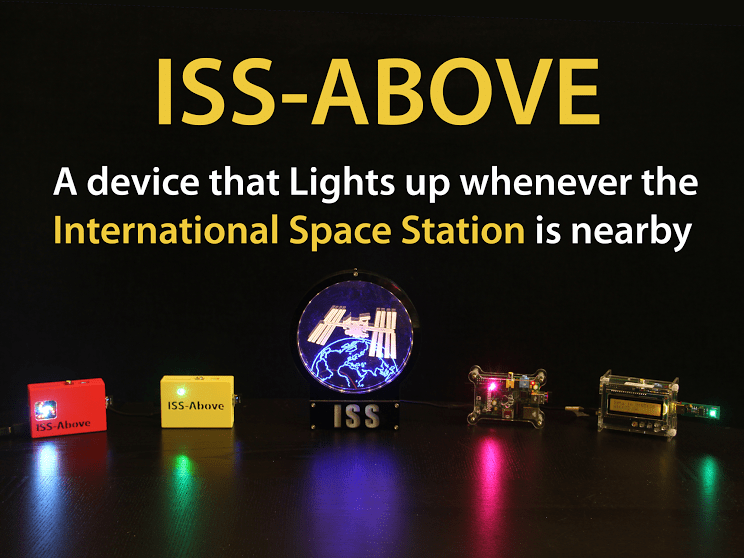
ISS-Above lights up when the International Space Station is going to fly over your location.
There’s a coffee shop in Pasadena, California that has a cool little device that lights up whenever the International Space Station is going to passover head, providing a little science lesson for patrons of the cafe. Called “ISS-Above,” the device is the brainchild of Liam Kennedy, a web designer, amateur astronomer and space enthusiast, and there’s a new Kickstarter for the project that will make the device available to anyone.
“It’s both an awareness thing, so more people get to know the Space Station is in their sky,” says Kennedy, “and it’s also to let those who are “up there” know that we know and appreciate what they are doing!”
That’s because not only does it light up when the ISS is nearby, it can also Tweet a message to the Space Station. Plus it has its own built-in web server to give you a ton of information about current and future passes.
It runs on a Raspberry Pi system with a memory card that can be loaded with your location information, so if you are a computer geek, this is totally up your alley! LEDs light up to alert you to the space station’s presence. There are different case options depending on how you’d like your own personal ISS-Above to look, including some colorful 3D-printed options.
But aren’t there already apps available that do this?
“True,” said Kennedy, “and I probably have almost all of them,” talking about the apps that will tell you when the ISS is going to be passing by. ”
“Those are great – BUT – that’s not what ISS-Above is about,” Kennedy said. “I wanted something small; a physical device that can just sit on a window sill or on a shelf beside the TV and light up every time the ISS is making a pass in my sky. Having these in my house for the past few months really has me understand the difference it makes to see just how frequently it passes nearby.”
For this Kickstarter, there are reward options that contain a complete ISS-Above and one of two types of colorful LED display devices, the PiGlow or the Ledborg. The PiGlow is unique with it’s circular/spiral layout while the Ledborg is intensely bright.
A complete ISS-Above device preloaded with your location is available for kicking in to the Kickstarter for $115. If you just want the memory card with your location and custom Twitter login for sending a Tweet to the ISS, then the price is just $42. There are several other options as well. The project has until February 27 to meet its funding goal of $5,000.
The device got its start when Kennedy decided to build his grandkids a device that would alert them when the ISS was going over their own backyards. He brought a sample of ISS-Above to the San Diego Mini Maker’s Faire and people went absolutely crazy for the device. (here’s their writeup about it) Then ISS-Above got noticed by Hackaday and Reddit
Why a Kickstarter? Kennedy said that while the hardware for the device can be assembled by anyone, he still has many people who have asked him to provide a complete package already setup for their location. But he can only do that if there is enough volume. “Volume means I can purchase the components with lower shipping costs and more efficiently configure and assemble complete units,” he said.
His ultimate goal is to have ISS-Above devices in all space/science museums and public observatories around the world, and for that he needs to develop public display versions of ISS-Above utilizing more extensive LED/graphics capabilities. But again, he needs support to make that possible.
You can read more about the ISS-Above Kickstarter and the pledge rewards here.
How the ISS-Above works. Image courtesy Liam Kennedy.
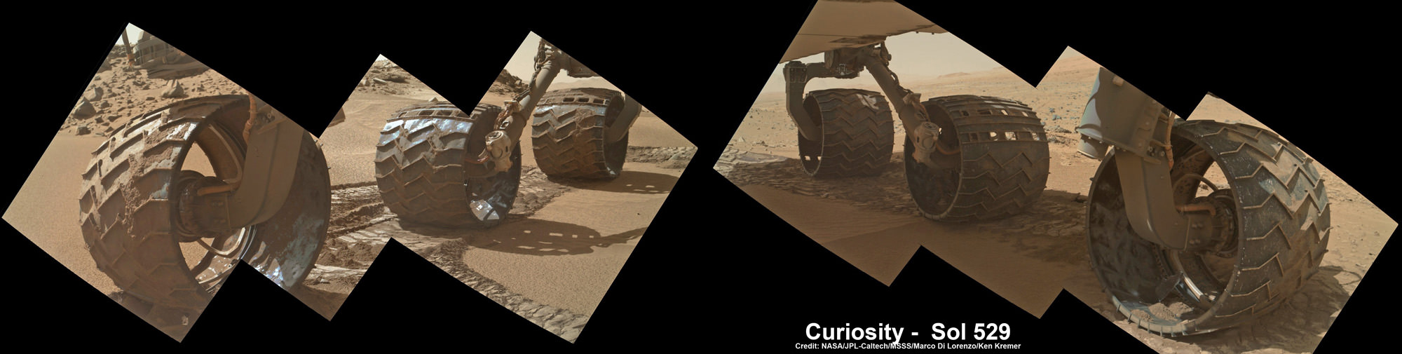
Up close photomosaic view shows lengthy tear in rover Curiosity’s left front wheel caused by recent driving over sharp edged Martian rocks on the months long trek to Mount Sharp. Raw images taken by the MAHLI camera on Curiosity’s arm on Jan. 31, 2014 (Sol 529) were assembled to show some recent damage to several of its six wheels Credit: NASA / JPL / MSSS / Marco Di Lorenzo / Ken Kremer- kenkremer.com See below complete 6 wheel mosaic and further wheel mosaics for comparison
Up close photomosaic view shows lengthy tear in rover Curiosity’s left front wheel caused by recent driving over sharp edged Martian rocks on the months long trek to Mount Sharp. The team is evaluating an alternate, smoother way forward to next science target. Raw images taken by the MAHLI camera on Curiosity’s arm on Jan. 31, 2014 (Sol 529) were assembled to show some recent damage to several of its six wheels.
Credit: NASA / JPL / MSSS / Marco Di Lorenzo / Ken Kremer- kenkremer.com
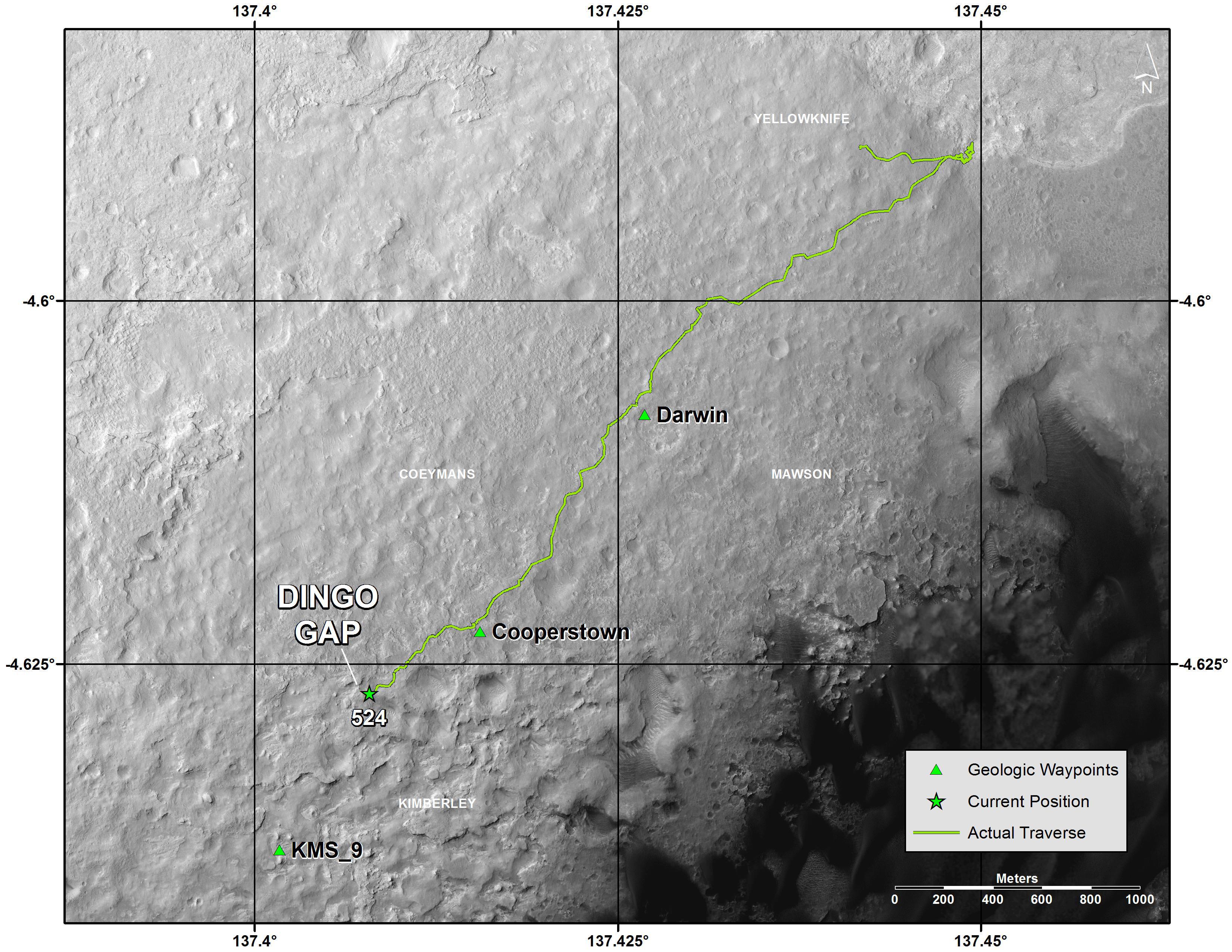
See below complete 6 wheel mosaic and ‘Dingo Gap’ dune alternate route mosaic plus 3-D view[/caption]
Continuing wheel damage from hoards of sharp edged Martian rocks are forcing engineers to seek a smoother pathway forward – potentially through a treacherous dune field – for NASA’s Curiosity rover on the jagged rock strewn road to Mount Sharp, her primary science destination.
Ever since rover engineers noticed holes and tears to the robots six aluminum wheels this past fall and winter 2013, the team has been photographing the wheels much more frequently and carefully assessing their condition. See our mosaics above and below.
Curiosity’s handlers are now considering diverting the SUV-sized robot to an alternate path crossing into a dune field and the valley beyond that entails traversing through much smoother Martian terrain to reach a highly desirable and nearby science destination called “KMS-9.”
Newly received images taken by the robot only on Friday, Jan. 31, reveal a very significant ragged looking puncture at least 2 to 3 inches (5 to 8 cm) in length and a inch or so (3 cm) wide that’s bent back to the inside of the left front wheel.
Curiosity’s View Past Tall Dune at edge of ‘Dingo Gap’
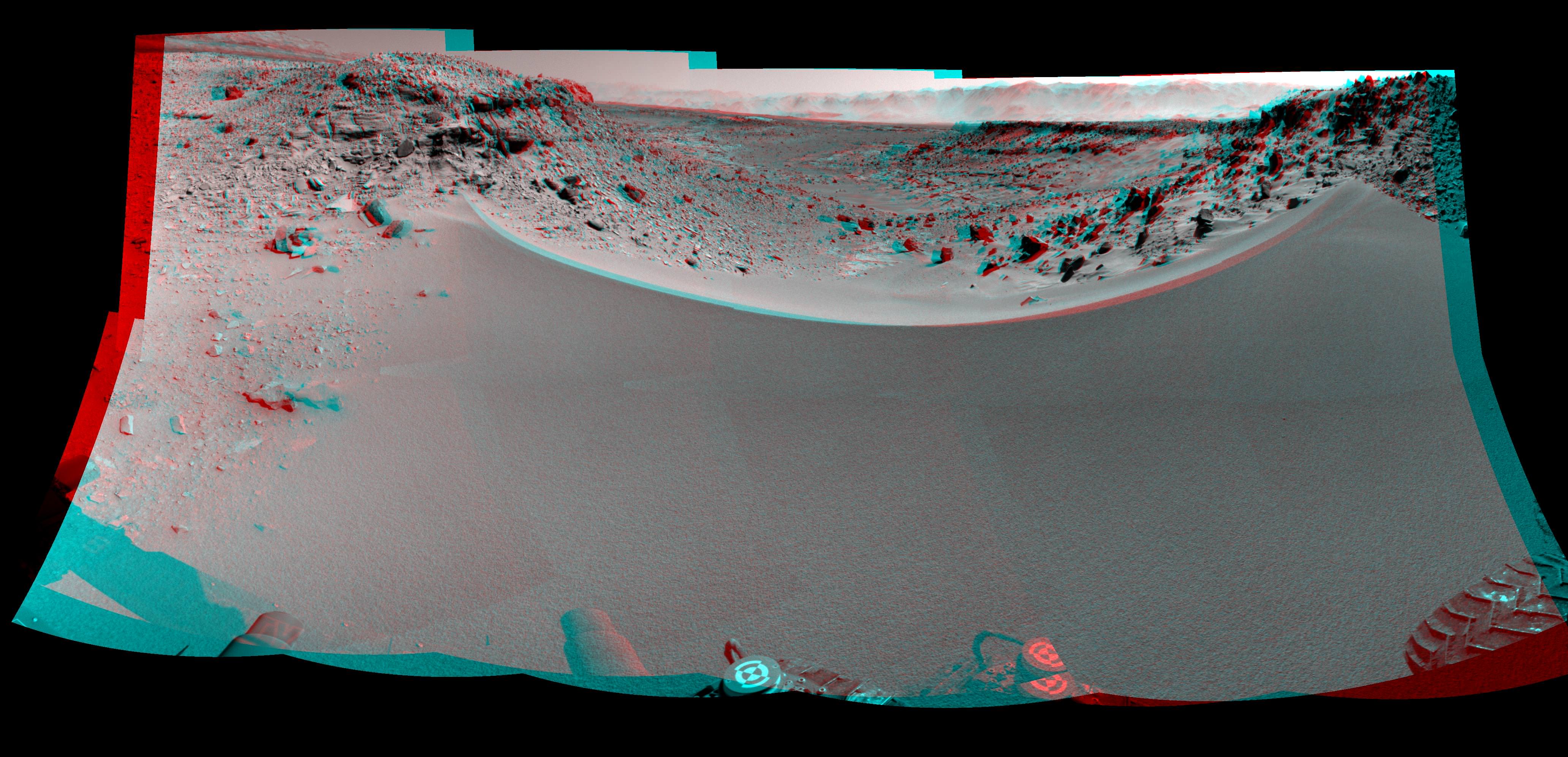
This photomosaic from Curiosity’s Navigation Camera (Navcam) taken at the edge of the entrance to the Dingo Gap shows a 3 foot (1 meter) tall dune and valley terrain beyond to the west, all dramatically back dropped by eroded rim of Gale Crater. View from the rover’s current position on Sol 528 (Jan. 30, 2014). The rover team may decide soon whether Curiosity will bridge the dune gap as a smoother path to next science destination. Credit: NASA/JPL-Caltech/Marco Di Lorenzo/Ken Kremer- kenkremer.com
See NASA’s 3-D view of Dingo Gap below
Unfortunately, the fields of rough Red Planet rocks have not been a blessing to the 1 ton behemoth.
See our new underbelly mosaic view of Curiosity’s holy wheels (above and below) snapped on Jan. 31, (Sol 529), that’s aimed at the interior and which vividly shows the extent of the injury to the 20 inch diameter wheel.
Photomosaic shows new holes and tears in several of rover Curiosity’s six wheels caused by recent driving over sharp edged Martian rocks on the months long trek to Mount Sharp. Raw images taken by the MAHLI camera on Curiosity’s arm on Jan. 31, 2014 (Sol 529) were assembled to show some recent damage to several of its six wheels. Credit: NASA / JPL / MSSS / Marco Di Lorenzo / Ken Kremer- kenkremer.com
The rate of wheel damage has picked up dramatically as the driving pace accelerated across the rugged, rock filled Martian terrain over the past six months and put over 4.89 kilometers (3.04 mi.) on the odometer to date since the nailbiting August 2012 landing.
The mega robot is now standing at the edge of the dune field by the picturesque entrance known as the “Dingo Gap” after driving another 865 feet (264.7 meters) during January 2014.
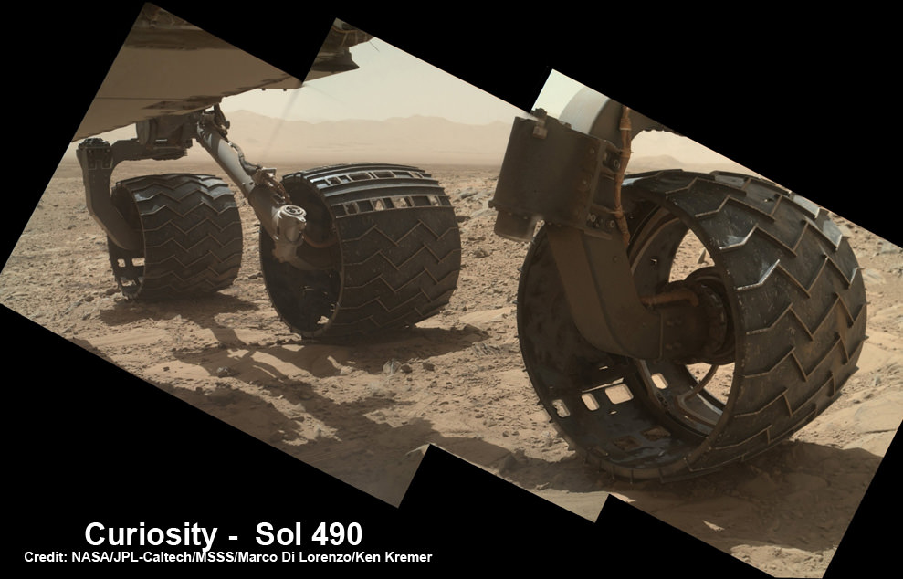
You can see the increased damage resulting from the past months drive by comparing the new Sol 529 view with our underbelly mosaic from Sol 490 in December 2013.
Photomosaic shows new holes and tears in several of rover Curiosity’s six wheels caused by recent driving over sharp edged Martian rocks on the months long trek to Mount Sharp. Raw images taken by the MAHLI camera on Curiosity’s arm on Dec. 22, 2013 (Sol 490) were assembled to show some recent damage to several of its six wheels – most noticeably the two here in middle and front. Credit: NASA / JPL / MSSS / Marco Di Lorenzo / Ken Kremer- kenkremer.com
However, the dune cutting across “Dingo Gap” measures about 3 feet (1 meter) in height.
Look at this 3-D “Dingo Gap” mosaic view from NASA and you can judge for yourself the choices the team faces.
Curiosity’s 3-D View Past Tall Dune at edge of ‘Dingo Gap’
This stereo mosaic of images from the Navigation Camera (Navcam) on Curiosity shows the terrain to the west from the rover’s position on Sol 528 (Jan. 30, 2014). The scene appears three dimensional when viewed through red-blue glasses with the red lens on the left. The view was taken just after Curiosity had arrived at the eastern edge of a location called “Dingo Gap.” A dune across the gap is about 3 feet (1 meter) high in the middle and tapered at south (left) and north (right) ends onto low scarps on either side of the gap. The rover team is evaluating possible driving routes on the other side before a decision whether the cross the gap. Credit: NASA/JPL-Caltech
So the team is evaluating whether that’s safe to bridge because they don’t want to get stuck in a hidden sand trap like the one that ultimately led to Spirit’s demise a few years back.
“The decision hasn’t been made yet, but it is prudent to go check,” said Jim Erickson of NASA’s Jet Propulsion Laboratory, Pasadena, Calif., project manager for Curiosity, in a NASA statement.
Up close view of hole in one of rover Curiosity’s six wheels caused by recent driving over rough Martian rocks. Mosaic assembled from Mastcam raw images taken on Dec. 22, 2013 (Sol 490). Credit: NASA/JPL/MSSS/Ken Kremer -kenkremer.com/Marco Di Lorenzo
“We’ll take a peek over the dune into the valley immediately to the west to see whether the terrain looks as good as the analysis of orbital images implies,” Erickson added, based on orbital images snapped by the High Resolution Imaging Science Experiment (HiRISE) camera on NASA’s Mars Reconnaissance Orbiter (MRO) circling overhead.
The team is also testing an array of different driving techniques to minimize the accumulation of wheel punctures, such as driving backwards or using only four of the six wheels to reduce the force of the wheels pushing against jagged rocks.
The “Dingo Gap” could offer a safer gateway to “KMS-9” along the journey of the rovers southwestwardly route to breathtaking foothills of Mount Sharp.
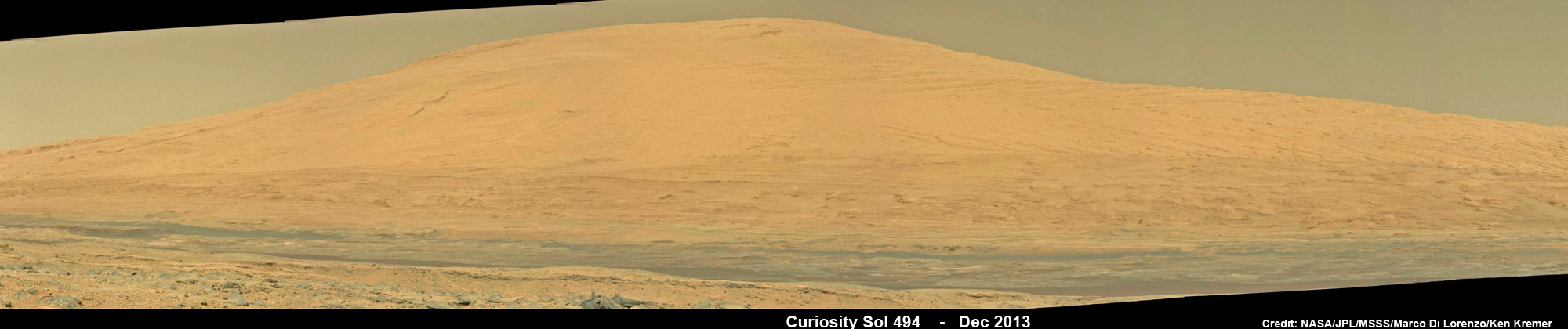
Curiosity Celebrates 500 Sols on Mars on Jan. 1, 2014. NASA’s Curiosity rover snaps fabulous new mosaic spying towering Mount Sharp destination looming dead ahead with her high resolution color cameras, in this cropped view. Imagery assembled from Mastcam raw images taken on Dec. 26, 2013 (Sol 494). Credit: NASA/JPL/MSSS/Marco Di Lorenzo/Ken Kremer- kenkremer.com
Dingo Gap lies between two low scarps and that is tapered off at both sides to the north and south.
KMS-9 is a potentially science rich target where the team hopes to conduct the first rock drilling operations since departing the Yellowknife Bay quadrant in July 2013.
The candidate drilling site lies only about half a mile (800 meters) away as the martian crow flies and features geology that’s appealing to the science team. But the roving routes under consideration are all much farther in actual distance.
“At KMS-9, we see three terrain types exposed and a relatively dust-free surface,” said science team collaborator Katie Stack of the California Institute of Technology, Pasadena.
Curiosity has already accomplished her primary goal of discovering a habitable zone on Mars that could support Martian microbes if they ever existed.
NASA’s rover Curiosity uncovered evidence that an ancient Martian lake had the right chemical ingredients, including clay minerals that could have sustained microbial life forms for long periods of time – and that these habitable conditions persisted on the Red Planet until a more recent epoch than previously thought.
As a result, the science team has shifted the missions focus to include the search for organic molecules – the building blocks of life as we know it – which may be preserved in the sedimentary rock layers of Mount Sharp.
“Really what we’re doing is turning the corner from a mission that is dedicated to the search for habitable environments to a mission that is now dedicated to the search for that subset of habitable environments which also preserves organic carbon,” Curiosity Principal Investigator John Grotzinger, of the California Institute of Technology in Pasadena, said recently at the Dec. 2013 annual meeting of the American Geophysical Union (AGU).
Meanwhile, NASA’s Opportunity rover is exploring clay mineral outcrops by the summit of Solander Point on the opposite side of the Mars at the start of her 2nd Decade investigating the Red Planets mysteries.
Read my new story about the Top 10 Decade 1 discoveries of Spirit and Opportunity – here.
Artist rendering of a supermassive black hole. Credit: NASA / JPL-Caltech.
A recent paper by Stephen Hawking has created quite a stir, even leading Nature News to declare there are no black holes. As I wrote in an earlier post, that isn’t quite what Hawking claimed. But it is now clear that Hawking’s claim about black holes is wrong because the paradox he tries to address isn’t a paradox after all.
It all comes down to what is known as the firewall paradox for black holes. The central feature of a black hole is its event horizon. The event horizon of a black hole is basically the point of no return when approaching a black hole. In Einstein’s theory of general relativity, the event horizon is where space and time are so warped by gravity that you can never escape. Cross the event horizon and you are forever trapped.
This one-way nature of an event horizon has long been a challenge to understanding gravitational physics. For example, a black hole event horizon would seem to violate the laws of thermodynamics. One of the principles of thermodynamics is that nothing should have a temperature of absolute zero. Even very cold things radiate a little heat, but if a black hole traps light then it doesn’t give off any heat. So a black hole would have a temperature of zero, which shouldn’t be possible.
Then in 1974 Stephen Hawking demonstrated that black holes do radiate light due to quantum mechanics. In quantum theory there are limits to what can be known about an object. For example, you cannot know an object’s exact energy. Because of this uncertainty, the energy of a system can fluctuate spontaneously, so long as its average remains constant. What Hawking demonstrated is that near the event horizon of a black hole pairs of particles can appear, where one particle becomes trapped within the event horizon (reducing the black holes mass slightly) while the other can escape as radiation (carrying away a bit of the black hole’s energy).
While Hawking radiation solved one problem with black holes, it created another problem known as the firewall paradox. When quantum particles appear in pairs, they are entangled, meaning that they are connected in a quantum way. If one particle is captured by the black hole, and the other escapes, then the entangled nature of the pair is broken. In quantum mechanics, we would say that the particle pair appears in a pure state, and the event horizon would seem to break that state.
Artist visualization of entangled particles. Credit: NIST.
Last year it was shown that if Hawking radiation is in a pure state, then either it cannot radiate in the way required by thermodynamics, or it would create a firewall of high energy particles near the surface of the event horizon. This is often called the firewall paradox because according to general relativity if you happen to be near the event horizon of a black hole you shouldn’t notice anything unusual. The fundamental idea of general relativity (the principle of equivalence) requires that if you are freely falling toward near the event horizon there shouldn’t be a raging firewall of high energy particles. In his paper, Hawking proposed a solution to this paradox by proposing that black holes don’t have event horizons. Instead they have apparent horizons that don’t require a firewall to obey thermodynamics. Hence the declaration of “no more black holes” in the popular press.
But the firewall paradox only arises if Hawking radiation is in a pure state, and a paper last month by Sabine Hossenfelder shows that Hawking radiation is not in a pure state. In her paper, Hossenfelder shows that instead of being due to a pair of entangled particles, Hawking radiation is due to two pairs of entangled particles. One entangled pair gets trapped by the black hole, while the other entangled pair escapes. The process is similar to Hawking’s original proposal, but the Hawking particles are not in a pure state.
So there’s no paradox. Black holes can radiate in a way that agrees with thermodynamics, and the region near the event horizon doesn’t have a firewall, just as general relativity requires. So Hawking’s proposal is a solution to a problem that doesn’t exist.
What I’ve presented here is a very rough overview of the situation. I’ve glossed over some of the more subtle aspects. For a more detailed (and remarkably clear) overview check out Ethan Seigel’s post on his blog Starts With a Bang! Also check out the post on Sabine Hossenfelder’s blog, Back Reaction, where she talks about the issue herself.
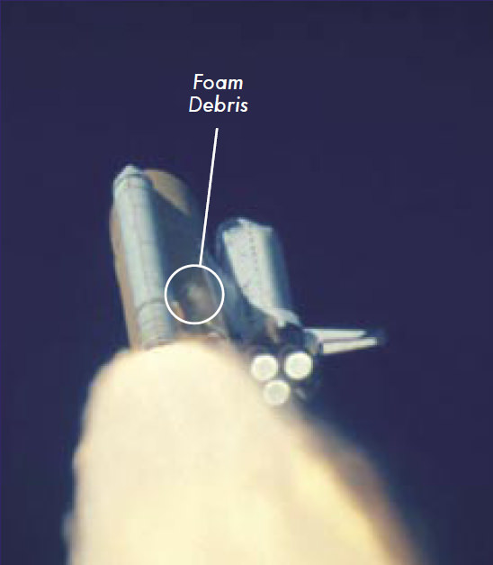
A shower of foam debris after the impact on Columbia?s left wing. The event was not observed in real time. Credit: NASA
The Columbia’s shuttle fiery end came as the STS-107 astronauts’ families were waiting runway-side for everyone to come home. NASA’s oldest space shuttle broke up around 9 a.m. Eastern (2 p.m. UTC) on Feb. 1, 2003, scattering debris along east Texas and nearby areas. Its demise was captured on several amateur video cameras, many of which were rebroadcast on news networks.
In the next four months, some 20,000 volunteers fanned out across the southwest United States to find pieces of the shuttle, coming up with 85,000 pieces (38% of the shuttle) as well as human remains. Meanwhile, investigators quickly zeroed in on a piece of foam that fell off of Columbia’s external tank and struck the wing. A seven-month inquiry known as the Columbia Accident Investigation Board eventually yielded that as the ultimate cause of the shuttle’s demise, although there were other factors as well.
The disaster killed seven people: Rick Husband, Willie McCool, Michael Anderson, Kalpana Chawla, David Brown, Laurel Clark and Ilan Ramon (who was Israel’s first astronaut.) At a time when most shuttles were focused on building the International Space Station, this crew’s mandate was different: to spend 24 hours a day doing research experiments. Some of the work was recoverable from the crew’s 16 days in space.
Columbia’s demise brought about several design changes in the external tank as NASA zeroed in on “the foam problem.” NASA put in a new procedure in orbit for astronauts to scan the shuttle’s belly for broken tiles using the robotic Canadarm and video cameras; shuttles also flew to the International Space Station in such a way so that astronauts on station could take pictures of the bottom.
Return-to-flight mission STS-114 in July-August 2005 yielded more foam loss than expected. Then NASA found something. For a long time, workers at the Michoud Assembly Facility were blamed for improper foam installation after partial tests on external tanks, but an X-ray analysis on an entire tank (done for reasons that are explained in this blog post from then-shuttle manager Wayne Hale) revealed it was actually due to “thermal cycles associated with filling the tank.”
“Discovery flew on July 4, 2006; no significant foam loss occurred. I consider that to be the real return to flight for the space shuttle,” he wrote. “So were we stupid? Yes. Can you learn from our mistake? I hope so.”
The Columbia crew. From the left: Mission Specialist David Brown, Commander Rick Husband, Mission Specialists Laurel Clark, Kalpana Chawla and Michael Anderson, Pilot William McCool and Payload Specialist Ilan Ramon. Credit: NASA.
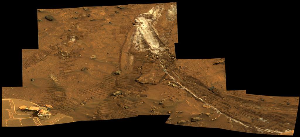
Carbonate-Containing Martian Rocks discovered by Spirit Mars Rover. Spirit collected data in late 2005 which confirmed that the Comanche outcrop contains magnesium iron carbonate, a mineral indicating the past environment was wet and non-acidic, possibly favorable to life. This view was captured during Sol 689 on Mars (Dec. 11, 2005). The find at Comanche is the first unambiguous evidence from either Spirit or Opportunity for a past Martian environment that may have been more favorable to life than the wet but acidic conditions indicated by the rovers' earlier finds. Credit: NASA/JPL-Caltech/Cornell University
A Top 10 Decade 1 Discovery by NASA’s Twin Mars Exploration Rovers
Carbonate-Containing Martian Rocks discovered by Spirit Mars Rover
Spirit collected data in late 2005 which confirmed that the Comanche outcrop contains magnesium iron carbonate, a mineral indicating the past environment was wet and non-acidic, possibly favorable to life. This view was captured during Sol 689 on Mars (Dec. 11, 2005). The find at Comanche is the first unambiguous evidence from either Spirit or Opportunity for a past Martian environment that may have been more favorable to life than the wet but acidic conditions indicated by the rovers’ earlier finds. Credit: NASA/JPL-Caltech/Cornell University Story updated[/caption]
January 2014 marks the 10th anniversary since the nail biting and history making safe landings of NASA’s renowned Mars Explorations Rovers – Spirit and Opportunity – on the Red Planet barely three weeks apart during January 2004.
Due to their completely unforeseen longevity, a decade of spectacular and groundbreaking scientific discoveries continuously flowed from the robot sisters that have graced many articles, magazine covers, books, documentaries and refereed scientific papers.
What are the Top 10 Decade 1 discoveries from Spirit and Opportunity?
Find out below what a top Mars rover team scientist told Universe Today!
Ray Arvidson, the rovers Deputy Principal Investigator and professor at Washington University in St. Louis, has kindly shared with me his personal list of the Top 10 discoveries from Spirit and Opportunity for the benefit of readers of Universe Today.
The Top 10 list below are Ray’s personal choices and does not necessarily reflect the consensus of the Mars Explorations Rover (MER) team.
First some background.
The dynamic duo were launched on their interplanetary voyages from Cape Canaveral Florida atop Delta II rockets during the summer of 2003.
The now legendary pair landed on opposite sides of the Red Planet. Spirit landed first on Jan. 3 inside Gusev Crater and twin sister Opportunity landed second on Jan. 24 on the dusty plains of Meridiani Planum.
A Moment Frozen in Time
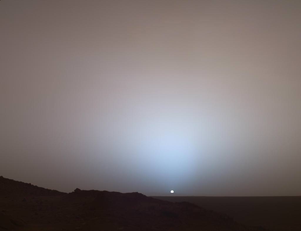
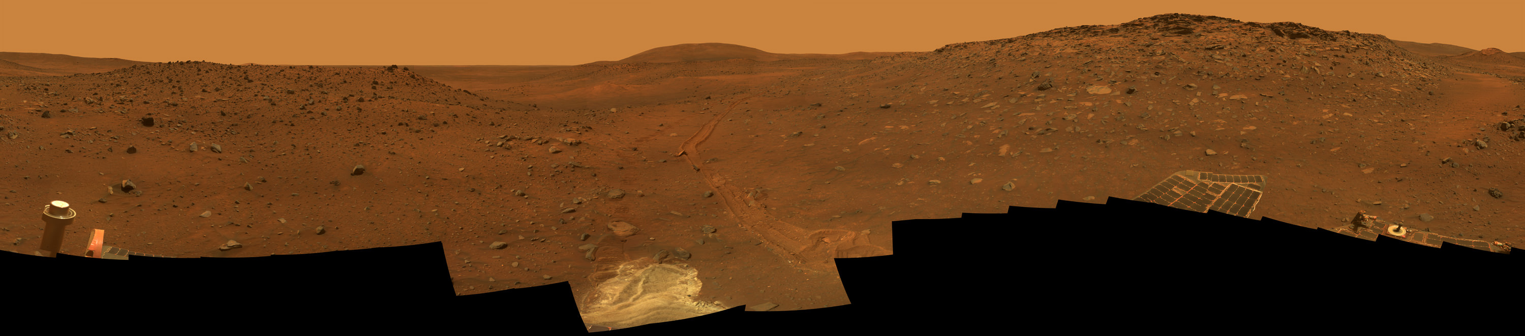
On May 19th, 2005, NASA’s Mars Exploration Rover Spirit captured this stunning view as the Sun sank below the rim of Gusev crater on Mars. This Panoramic Camera (Pancam) mosaic was taken around 6:07 in the evening of Sol 489. The terrain in the foreground is the rock outcrop “Jibsheet,” a feature that Spirit has been investigating for several weeks (rover tracks are dimly visible leading up to “Jibsheet”). The floor of Gusev crater is visible in the distance, and the Sun is setting behind the wall of Gusev some 80 km (50 miles) in the distance. Credit: NASA/JPL-Caltech/Texas A&M/Cornell
The goal was to “follow the water” as a potential enabler for past Martian microbes if they ever existed.
Together, the long-lived, golf cart sized robots proved that early Mars was warm and wet, billions of years ago – a key finding in the search for habitats conducive to life beyond Earth.
The solar powered robo duo were expected to last a mere three months – with a ‘warrenty’ of 90 Martian days (Sols).
Spirit endured the utterly extreme Red Planet climate for more than six years until communications ceased in 2010.
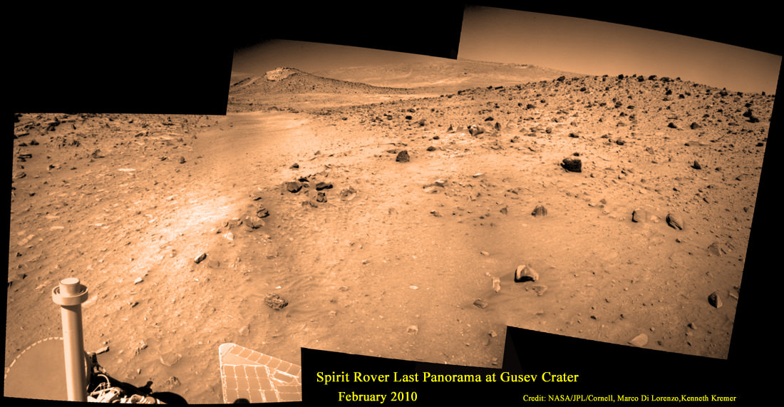
Last View from Spirit rover on Mars
Spirit’s last panorama from Gusev Crater was taken during February 2010 before her death from extremely low temperatures during her 4th Martian winter. Spirit was just 500 feet from her next science target – dubbed Von Braun – at center, with Columbia Hills as backdrop. Mosaic Credit: Marco Di Lorenzo/ Kenneth Kremer/ NASA/JPL/Cornell University.
Mosaic featured on Astronomy Picture of the Day (APOD) on 30 May 2011 – http://apod.nasa.gov/apod/ap110530.html
Opportunity lives on TODAY and is currently exploring by the summit of Solander Point on the western rim of a vast crater named Endeavour that spans some 22 kilometers (14 miles) in diameter.
“Because of the rovers’ longevity, we essentially got four different landing sites for the price of two,” says the rovers’ Principal Investigator, Steve Squyres of Cornell University, Ithaca, N.Y.
Here are the Top 10 MER discoveries from Ray Arvidson, Deputy Principal Investigator
1. Opportunity: Ancient Acidic Martian Lakes
The Meridiani plains Burns formation as sulfate-rich sandstones with hematitic concretions formed in ancient acidic and oxidizing shallow lakes and reworked into sand dunes and cemented by rising groundwaters.
‘Burns Cliff’ Color Panorama Opportunity captured this view of “Burns Cliff” after driving right to the base of this southeastern portion of the inner wall of “Endurance Crater.” The view combines frames taken by Opportunity’s panoramic camera between the rover’s 287th and 294th martian days (Nov. 13 to 20, 2004). The mosaic spans more than 180 degrees side to side. Credit: NASA/JPL-Caltech/Cornell
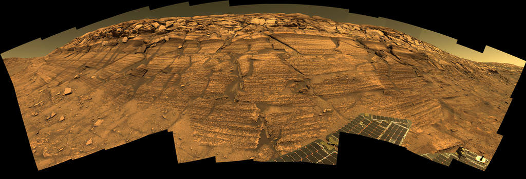
2. Opportunity: Phyllosilicate Clays at ‘Whitewater Lake’ at Endeavour Crater indicate Ancient Habitable Zone
At the rim of Endeavour crater and the Cape York rim segment the discovery of ferric and aluminous smectite [phyllosilicate] clays in the finely-layered Matijevic formation rocks that pre-exist the Endeavour impact event.
Pancam false-color view acquired on Sol 3066 (Sept. 8 2012) of fine-scale layering in the Whitewater Lake locality that is indicative of an ancient aqueous environment on Mars. Veneers have been resistant to wind erosion and enhanced the layered appearance of the outcrop. Layers are typically several millimeters thick. Credit: NASA/JPL-Caltech/Cornell/Arizona State University
Alteration in moderately acidic and reducing waters, perhaps mildly oxidizing for ferric smectites. These are the oldest rocks examined by Opportunity and the waters are much more habitable than waters that led to Burns formation.
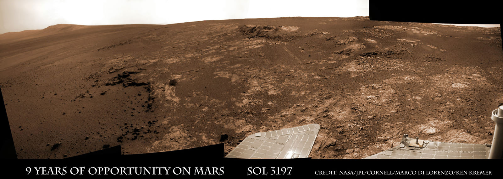
Opportunity rover discovered phyllosilicate clay minerals and calcium sulfate veins at the bright outcrops of ‘Whitewater Lake’, at right, imaged by the Navcam camera on Sol 3197 (Jan. 20, 2013, coinciding with her 9th anniversary on Mars. “Copper Cliff” is the dark outcrop, at top center. Darker “Kirkwood” outcrop, at left, is site of mysterious “newberries” concretions. This panoramic view was snapped from ‘Matijevic Hill’ on Cape York ridge at Endeavour Crater. Credit: NASA/JPL-Caltech/Cornell/Marco Di Lorenzo/Ken Kremer
3. Opportunity: Martian Meteorites
Many meteorites were found [throughout the long traverse] that are dispersed across the Meridiani plains landing site
4. Opportunity: Wind-blown sand ripples
Wind-blown sand ripples throughout the Meridiani plains relict from the previous wind regime, probably when Mars spin axis tilt was different than today’s value
5. Spirit: Opaline silica indicates Ancient Hydrothermal system
Discovery of Opaline silica at Home Plate, Gusev Crater. This formed in volcanic fumeroles and/or hydrothermal vents indicating that water was interacting with magma.
Spirit acquired this mosaic on Sol 1202 (May 21, 2007), while investigating the area east of the elevated plateau known as “Home Plate” in the “Columbia Hills.” The mosaic shows an area of disturbed soil, nicknamed “Gertrude Weise” by scientists, made by Spirit’s stuck right front wheel. The trench exposed a patch of nearly pure silica, with the composition of opal. It could have come from either a hot-spring environment or an environment called a fumarole, in which acidic, volcanic steam rises through cracks. Either way, its formation involved water, and on Earth, both of these types of settings teem with microbial life. Credit: NASA/JPL-Caltech/Cornell
6. Spirit: Carbonates at Comanche – see lead image above
The discovery of Fe-Mg [iron-magnesium] carbonates at the Comanche outcrop on Husband Hill, Gusev Crater, again showing that water interacted with magma.
Note: Carbonates form in neutral, non-acid water. This was the first time they were found and investigated examined on the surface Mars during Dec. 2005.
7. Spirit: Ferric sulfates moved by modern water
Ferric sulfates moved down the soil column by modern waters at Troy and Husband Hill in Gusev Crater.
‘Calypso’ Panorama of Spirit’s View from ‘Troy’. This full-circle view from the panoramic camera (Pancam) on NASA’s Mars Exploration Rover Spirit shows the terrain surrounding the location called “Troy,” where Spirit became embedded in soft soil during the spring of 2009. The hundreds of images combined into this view were taken beginning on the 1,906th Martian day (or sol) of Spirit’s mission on Mars (May 14, 2009) and ending on Sol 1943 (June 20, 2009). Credit: NASA/JPL-Caltech/Cornell University
8. Spirit: Modern water alters rocks
Complex coatings on olivine basalts on the Gusev Crater plains showing modern water or frost has altered rock surfaces
9. Both rovers: Martian Dust Devils
The finding [and imaging] of dust devil frequency and dynamics, showing how dust and sand are moved by wind in the very thin Martian atmosphere.
Note: Wind action occasionally cleaning off the solar panels led to their unexpected longevity
See a dust devil imaged in our Solander Point mosaic below
Spirit Mars rover – view from Husband Hill summit – panels cleaned by wind action
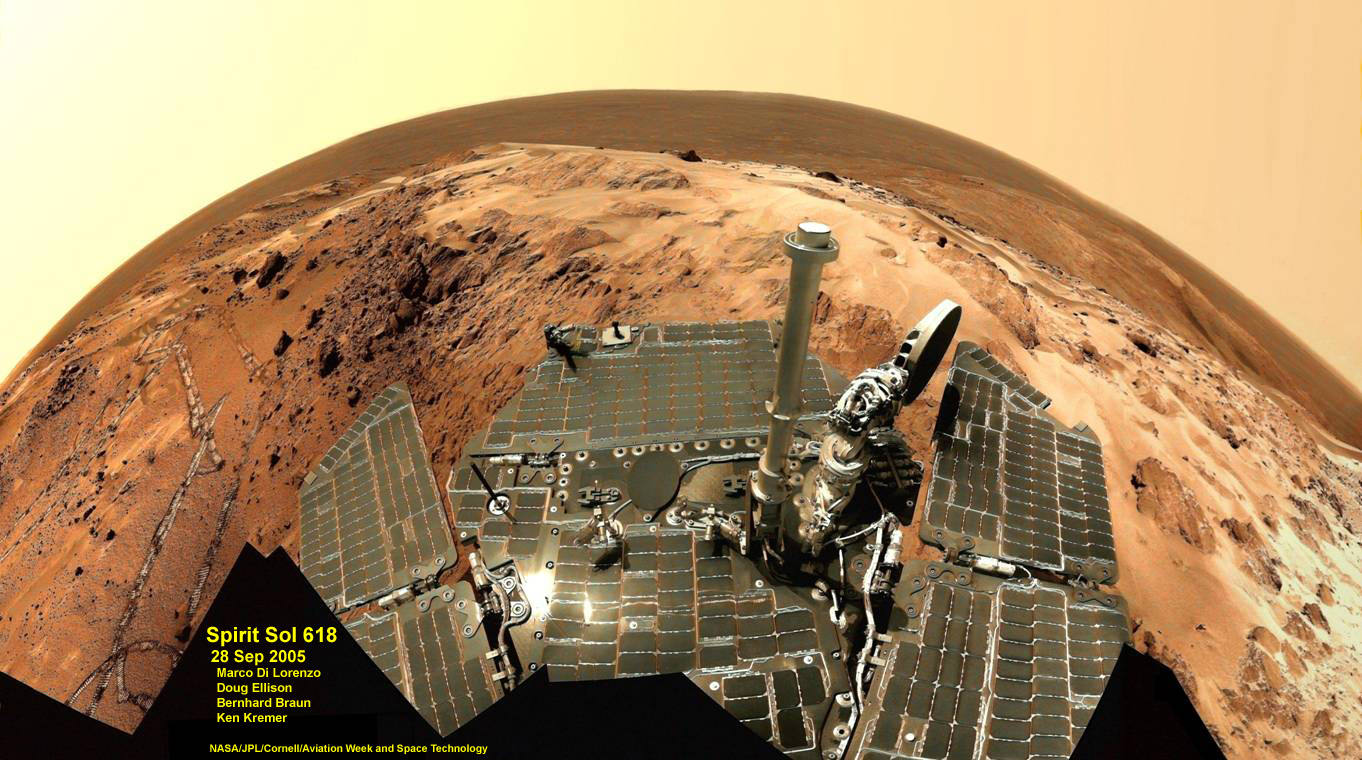
Spirit snapped this unique self portrait view from the summit of Husband Hill inside Gusev crater on Sol 618 on 28 September 2005. The rovers were never designed or intended to climb mountains. It took more than 1 year for Spirit to scale the Martian mountain. This image was created from numerous raw images by an international team of astronomy enthusiasts and appeared on the cover of the 14 November 2005 issue of Aviation Week & Space Technology magazine and the April 2006 issue of Spaceflight magazine. Also selected by Astronomy Picture of the Day (APOD) on 28 November 2005. Credit: NASA/JPL/Cornell/ Marco Di Lorenzo/Doug Ellison/Bernhard Braun/Ken Kremer – kenkremer.com
10. Both rovers: Atmospheric Argon measurements
Argon gas was used as a tracer of atmospheric dynamics by both rovers. It was measured by using the APXS (Alpha Particle X-Ray Spectrometer) on the robotic arm to measure the Martian atmosphere and detect argon
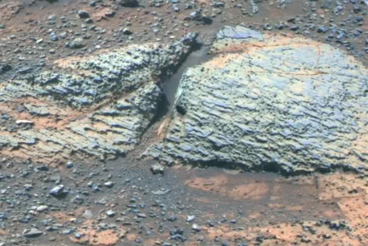
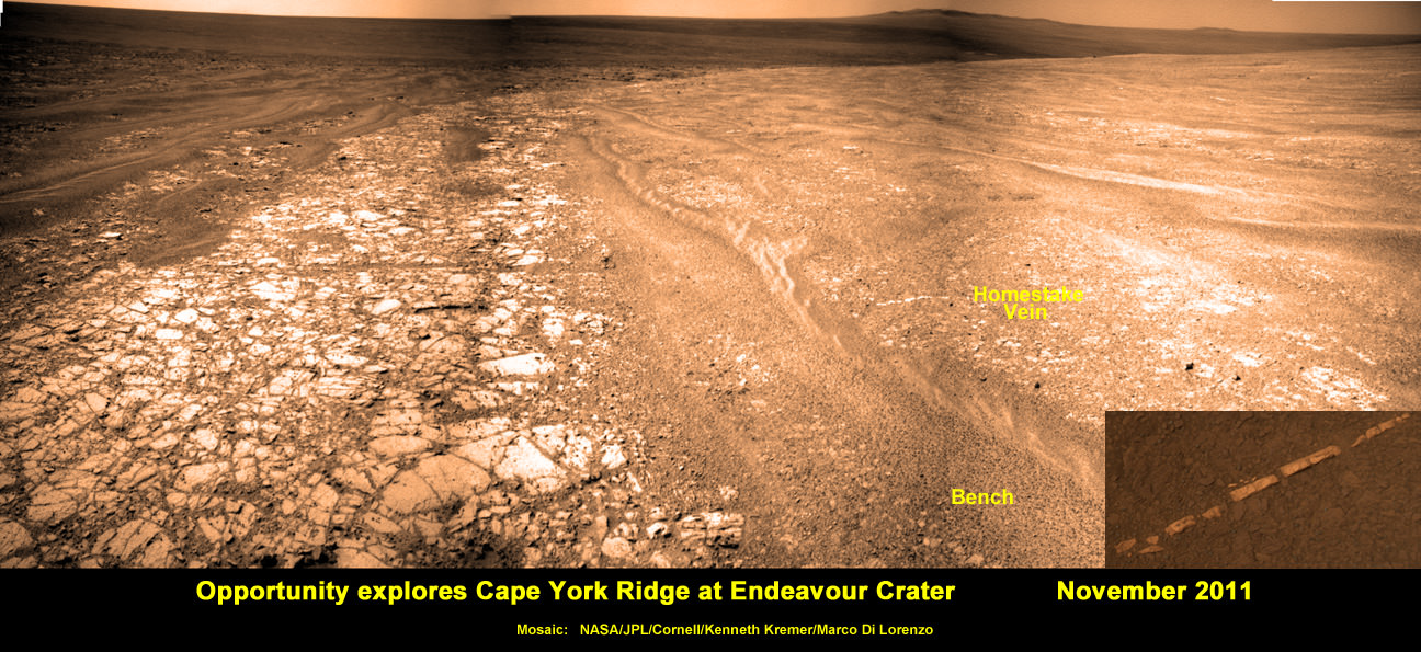
Another major discovery by Opportunity was the finding of hydrated mineral veins of calcium sulfate in the bench surrounding Cape York. The vein discovery is another indication of the ancient flow of liquid water in this region on Mars.
Opportunity discovers hydrated Mineral Vein at Endeavour Crater – November 2011. Opportunity determined that the ‘Homestake’ mineral vein was composed of calcium sulfate,or gypsum, while exploring around the base of Cape York ridge at the western rim of Endeavour Crater. The vein discovery indicates the ancient flow of liquid water at this spot on Mars. This panoramic mosaic of images was taken on Sol 2761, November 2011, and illustrates the exact spot of the mineral vein discovery. Featured on NASA Astronomy Picture of the Day (APOD) on 12 Dec 2011 – http://apod.nasa.gov/apod/ap111212.html. Credit: NASA/JPL/Cornell/Kenneth Kremer/Marco Di Lorenzo.
Altogether, Spirit snapped over 128,000 raw images, drove 4.8 miles (7.7 kilometers) and ground into 15 rock targets.
Opportunity is currently investigating a new cache of exposed clay mineral outcrops by the summit of Solander Point, a rim segment just south of Cape York and Matejivic Hill.
These new outcrops at ‘Cape Darby’ like those at ‘Esperance’ at Matijevic Hill were detected based on spectral observations by the CRISM spectrometer aboard NASA’s Mars Reconnaissance Orbiter (MRO) circling overhead, Arvidson told me.
Opportunity by Solander Point peak – 2nd Mars Decade Starts here!
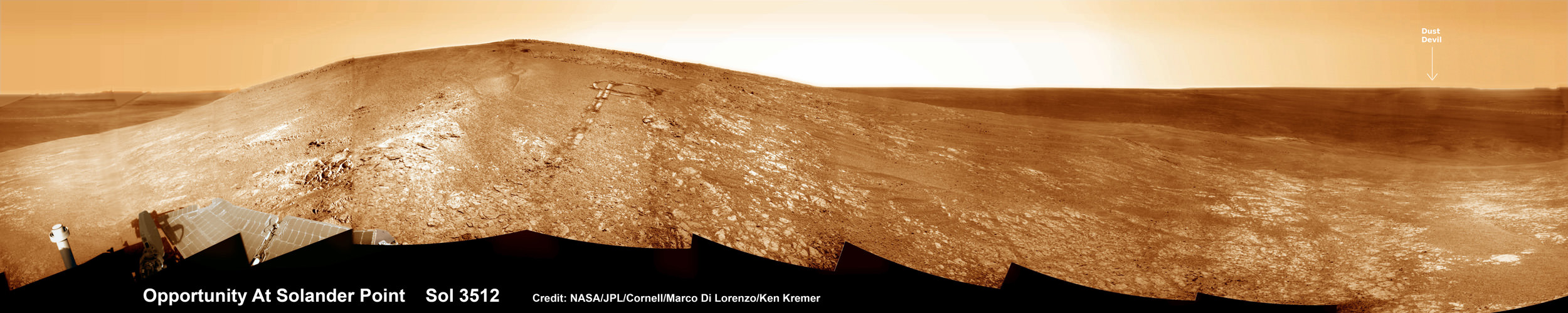
NASA’s Opportunity rover captured this panoramic mosaic on Dec. 10, 2013 (Sol 3512) near the summit of “Solander Point” on the western rim of vast Endeavour Crater where she starts Decade 2 on the Red Planet. She is currently investigating summit outcrops of potential clay minerals formed in liquid water on her 1st mountain climbing adventure. See wheel tracks at center and dust devil at right. Assembled from Sol 3512 navcam raw images. Credit: NASA/JPL/Cornell/Marco Di Lorenzo/Ken Kremer-kenkremer.com
Today, Jan. 31, marks Opportunity’s 3563rd Sol or Martian Day roving Mars – for what was expected to be only a 90 Sol mission.
So far she has snapped over 188,200 amazing images on the first overland expedition across the Red Planet.
Her total odometry stands at over 24.07 miles (38.73 kilometers) since touchdown on Jan. 24, 2004 at Meridiani Planum.
Meanwhile on the opposite side of Mars, Opportunity’s younger sister rover Curiosity is trekking towards gigantic Mount Sharp. She celebrated 500 Sols on Mars on New Years Day 2014.
What’s Ahead for Opportunity in Decade 2 on Mars ?
Many more ground breaking discoveries surely lie ahead for Opportunity since she is currently exploring ancient terrain at Endeavour crater that’s chock full of minerals indicative of a Martian habitable zone.
She remains healthy and the solar panels are generating enough power to actively continue science investigations throughout her 6th frigid Martian winter!
NASA’s Opportunity Mars rover recorded the component images for this self-portrait near the peak of Solander Point and about three weeks before completing a decade of work on Mars. The rover’s panoramic camera (Pancam) took the images during the interval Jan. 3, 2014, to Jan. 6, 2014. Credit: NASA/JPL-Caltech/Cornell/Arizona State University
Therefore – Stay tuned here for Ken’s continuing Opportunity, Curiosity, Chang’e-3, LADEE, MAVEN, Mars rover and MOM news.
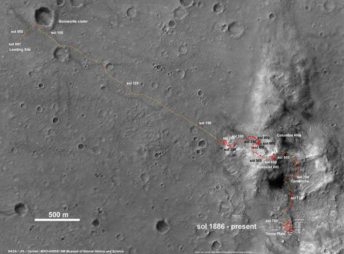
Spirit Rover traverse map from Gusev Crater landing site to Home Plate: 2004 to 2011Traverse Map for NASA’s Opportunity rover from 2004 to 2014
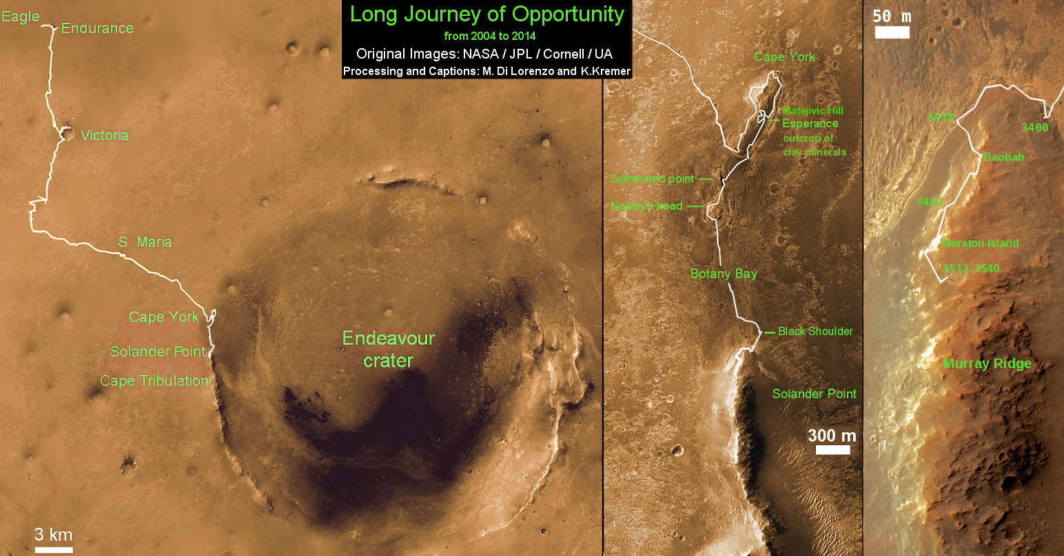
This map shows the entire path the rover has driven during a decade on Mars and over 3560 Sols, or Martian days, since landing inside Eagle Crater on Jan 24, 2004 to current location by Solander Point summit at the western rim of Endeavour Crater. Rover will spend 6th winter here atop Solander. Opportunity discovered clay minerals at Esperance – indicative of a habitable zone. Credit: NASA/JPL/Cornell/ASU/Marco Di Lorenzo/Ken Kremer – kenkremer.com
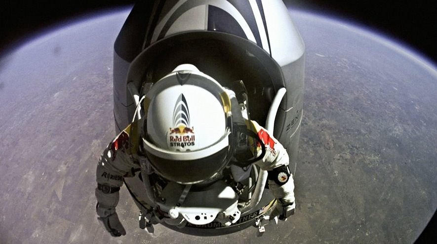
Felix Baumgartner about to step out of his pressurized capsule on October 14, 2012 (Credit: Red Bull)
Remember BASE jumper Felix Baumgartner’s incredible freefall from the “edge of space” in October 2012? The highly anticipated (and highly publicized) Red Bull-sponsored stunt was watched live by viewers around the world (including me — it was very cool!) and set new records for highest jump, fastest freefall, and highest balloon-powered human flight. That day Baumgartner even broke the long-standing record held by his mentor Col. Joe Kittinger, who jumped from 102,800 feet in August 1960… and with seven GoPro Hero2 cameras mounted to Felix’s high-tech suit and helmet, you can see what he saw during every one of the 127,852 feet that he fell down to Earth.
(That’s ah, over 24 miles/39 km. *Gulp.*)
The video above was released today by GoPro, and is a more polished and edited version than the one released by Red Bull this past October. Check it out above, or for full vertigo-inducing* freefall effect watch it in fullscreen HD on YouTube. *Consider yourself warned!
Artist's conception of Kepler 34b, which orbits two stars. Credit: David A. Aguilar (CfA)
Binary star systems are downright dangerous due to their complex gravitational interactions that can easily grind a planet to pieces. So how is it that we have found a few planets in these Tattooine-like environments?
Research led by the University of Bristol show that most planets formed far away from their central stars and then migrated in at some point in their history, according to research collected concerning Kepler-34b and other exoplanets.
The scientists did “computer simulations of the early stages of planet formation around the binary stars using a sophisticated model that calculates the effect of gravity and physical collisions on and between one million planetary building blocks,” stated the university.
“They found that the majority of these planets must have formed much further away from the central binary stars and then migrated to their current location.”
You can read more about the research in Astrophysical Journal Letters. It was led by Bristol graduate student Stefan Lines with participation from advanced research fellow and computational astrophysicst Zoe Lienhardt, among other collaborators.
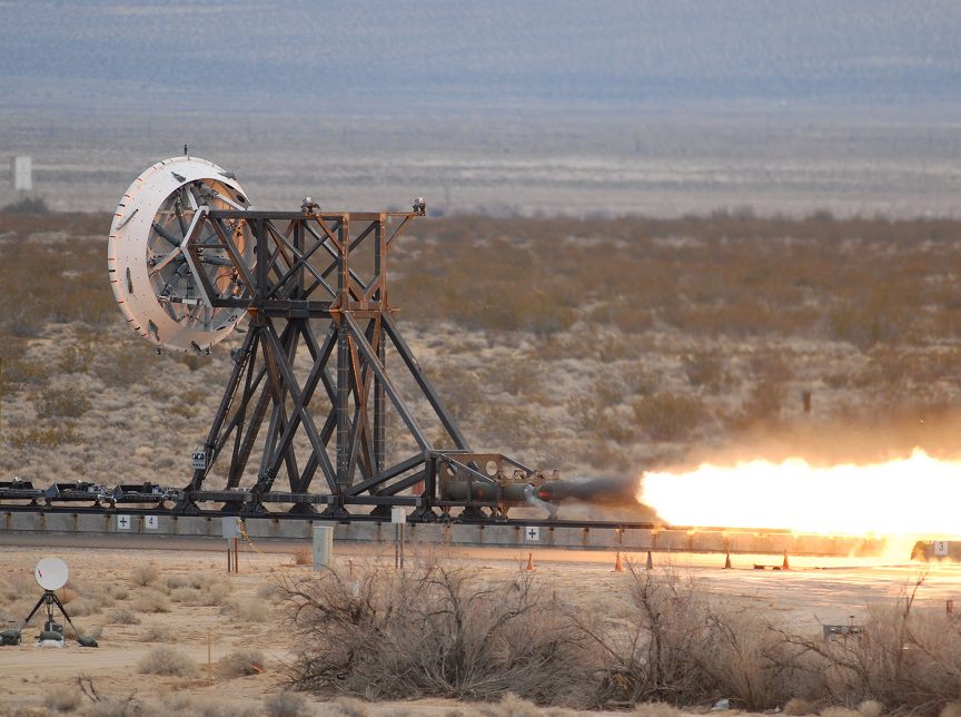
The "rocket sled" that is a part of the Low-Density Supersonic Decelerator Project testing methods to slow spacecraft before they land. Credit: NASA
Watch the video above to the two-minute mark (and beyond) and we guarantee a brilliant start to your Friday. “Enter Sandman” indeed, Metallica. Look past the flames and thrust, however, and you will see a parachute test in action that could help spacecraft land safely on Mars one day.
This is an undated “rocket sled” test of the Low-Density Supersonic Decelerator, a technology aiming to be a more advanced way to bring spacecraft to Mars besides the 1970s-era Viking parachutes that were used as late as the Curiosity mission.
And supersonic flight tests of this technology will take place this year and next, according to NASA. The technology could be used on spacecraft as early as 2018, the agency added.
“NASA seeks to use atmospheric drag as a solution, saving rocket engines and fuel for final maneuvers and landing procedures,” the agency states on the project’s web page. “The heavier planetary landers of tomorrow, however, will require much larger drag devices than any now in use to slow them down — and those next-generation drag devices will need to be deployed at higher supersonic speeds to safely land vehicle, crew and cargo.”
“One of the tests on my LDSD project, which combines the Navy version of a Blackhawk helicopter, a giant 110 foot parachute, 3000 pounds of rope, a very big pulley, four rockets, and a railroad track in the desert. The test successfully uncovered a design flaw in the parachute before we flew one like it on a much more expensive test — which is exactly what this test was for,” wrote collaborator Mark Adler (a fellow at the Jet Propulsion Laboratory who was a mission manager for the Spirit rover) on Google Plus.
As part of this project, NASA is testing three devices. The first is a huge parachute (30.5 meters, or 100 feet) that will deploy when the spacecraft is at about 1.5 to 2 times the speed of sound to slow it down.
NASA’s Curiosity rover heads for a successful landing Aug. 6 under its parachute. Picture snapped by NASA’s Mars Reconnaissance Orbiter’s High-Resolution Imaging Science Experiment (HiRISE). Credit: NASA/JPL-Caltech/Univ. of Arizona
At faster speeds, NASA also plans inflatable aerodynamic decelerators, which it describes as “very large, durable, balloon-like pressure vessels.” These devices are being tested in two versions: six-meter and eight-meter (19.7 feet and 26.2 feet). They are designed to balloon around the spacecraft to slow it down from 3.5 times the speed of sound to at least twice the speed of sound, if not lower.
“All three devices will be the largest of their kind ever flown at speeds several times greater than the speed of sound,” NASA stated.
The project is a NASA technology demonstration mission led by the Jet Propulsion Laboratory. This test and similar ones were conducted at the conducted at the U.S. Naval Air Weapons Station at China Lake, Calif. More videos and information are available at LDSD’s webpage.
Huge hat-tip to @marsroverdriver for highlighting this on his Twitter account yesterday (Thursday).
“What sort of gear did you use to capture that?” folks ask, imagining that I’m using a setup that required a second mortgage to pay for.
People are often surprised at the fact that I’m simply using a converted off-the-shelf webcam modified to fit into the eyepiece-holder of a telescope, along with freeware programs to control the camera, stack,and clean up images. And while there are multi-thousand dollar rigs available commercially that yield images that would have been the envy of professional observatories even a decade ago, you may just find that you have the gear lying around to start doing planetary and lunar photography tonight.
OK, I’ll admit: you do need a laptop and telescope, (things that we typically have “laying around” our house!) but these are the two priciest items on the list to get started. Living the vagabond life of a veteran, a teacher, and a freelance science writer assures that our preferred cameras for conversion are always in the double-digit dollar range.
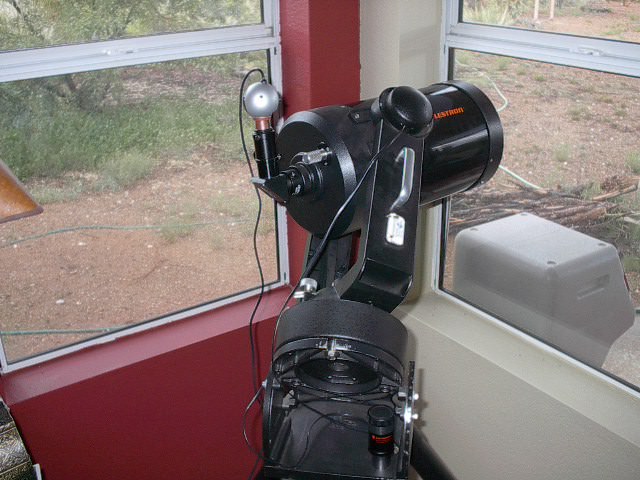
Our first converted “Planetcam” installed on the ‘scope.
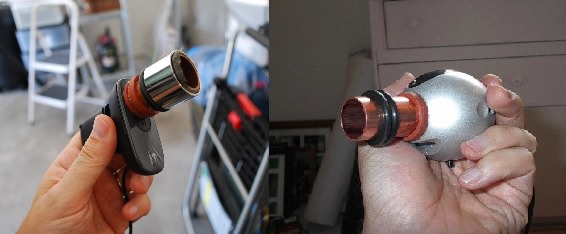
But converted webcam imaging is not new. We first read about the underground movement over a decade ago. Back in the day, amateur astrophotographers were hacking their Phillips Vesta and ToUcam Pro webcams with stunning results. Celestron, Meade and Orion later caught up to the times and released their own commercial versions for planetary imaging some years later.
A few freeware installations and the modification of a Logitech 3000 that I bought on rebate for 50$ later, and I was soon imaging planets that same night.
Modified webcams, old (right) and new (left).
Just about any webcam will yield decent results, though the discontinued Phillips ToUcam Pro webcams are still the heavily sought after Holy Grail of webcam astrophotography. The modification simply consists of removing the camera lens (don’t do this with any camera that you don’t want to gut and void the warranty) and attaching a standard 1 ¼” eyepiece barrel in its place using cement glue.
For camera control, I use a program called K3CCDTools. This was freeware once upon a time, now the program costs $50 to install. I still find it well worth using, though I’ve been turned on to some equally useful programs out there that are still free. (more on that in a bit).
K3CCDTools will process your images from start to finish, but I find that Registax is great for post-image processing. Plus, you don’t want to waste valuable scope time processing images: I do the maximum number of video captures in the field, and then tinker with them later on cloudy nights.
A screen capture of K3CCD tools during a daytime alignment test. Note the focusing dialog (FFT) box to the right.
Stacking video captures enables you to “grab” those brief moments of fine atmospheric seeing. Many astrophotographers will manually select the best frames from thousands one by one, but I’ll have to admit we’re often impatient and find the selection algorithm on Registax does an acceptable job of selecting the top 10% of images in a flash.
And like Photoshop, a college course could be taught around Registax. Don’t be intimidated, but do feel free to experiment! After stacking and optimizing, we find the true power in making the images “pop” often lies in the final step, known as wavelet processing. A round of sharpening and contrast boosting in Photoshop can also go a long way, just remember that the goal is to apply the minimum to get the job done, rather than looking unnatural and over-processed.
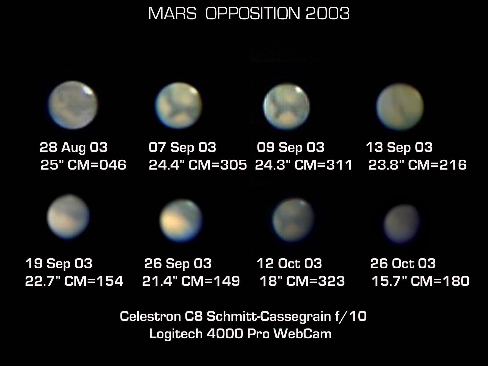
A photo mosaic of the historic Mars opposition of 2003.
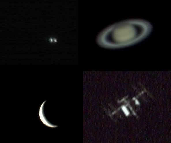
At the eyepiece, the first target hurdle is object acquisition. A standard webcam can go after bright targets such as the Moon, the Sun (with the proper filter) planets, and bright double stars. We’ve even nabbed the International Space Station with our rig using a low-tech but effective tracking method. Your field of view, however, will typically be very narrow; my webcam coupled to a Celestron C8” Schmidt-Cassegrain typically yields a field of view about 10’ on a side. You’ll want to center the object in the eyepiece at the highest power possible, then plop the camera in place.
The next battle is centering and focusing the object on the screen. An out-of-focus planet scatters light: tweaking the focus back and forth sometimes reveals the silvery “doughnut” of the planet lurking just out of view.
From there, you’ll want the object in as razor sharp a focus as possible. K3CCDTools has a great feature for this known as a Fine Focusing Tool (FFT). Some observers also using focusing masks, which can also be easily built — remember, were being cheapskates! — out of cardboard. Be sure those reflector mirrors are properly collimated as well.
Objects shot over the years (clockwise from the upper left): the close double star Porrima, Saturn, the International Space Station, and Venus.
Don’t be surprised if the planet initially looks over-saturated. You’ll want to access the manual controls of via the camera software to take the brightness, contrast and color saturation down to acceptable levels. I typically shoot at about 15 frames a second. Fun Fact: the “shutter speed” of the dark adapted “Mark 1 human eyeball” is generally quoted around 1/20th of a second, slower than you’d think!
Note: all those thousands of frames of video go somewhere… be sure to occasionally clean them off your hard-drive, as it will swiftly fill up!
When you image makes a big difference as well. The best time to shoot an object is when it transits the local north-south meridian and is at its highest point above the horizon. The reason for this is that you’re looking through the thinnest possible cross-section of the often turbulent atmosphere.
Universe Today reader Scott Chapman of Montpelier, Virginia also recently shared with us his exploits in planetary webcam imaging and his technique:
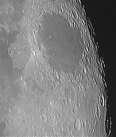
A webcam image of the Mare Crisium region on the Moon. Credit-Scott Chapman
“Recently, while looking for an affordable basic telescope, to see if I really had any interest in astronomy, searches and reviews led me to purchase a 70mm refractor. The last thing on my mind was that I could expect to take any pictures of what I might see.
Previously, I had assumed that the only way to take even basic pictures of sky objects was with equipment that was way out of my price range. Imagine my surprise to learn that I could use a simple webcam that I already had sitting around!”
Like many of us mere mortal budget astrophotographers, Scott’s goal was great images at low cost. He also shared with us the programs he uses;
–SharpCap2: For capturing .avi video files from the webcam connected to the telescope.
–AutoStakkert2: Selects and stacks the best frames into a single .tiff file using a simple 3-step process. Scott notes that its “MUCH easier for a beginner to use than Registax!”
-Registax6: The latest version of the software mentioned above.
–JPEGView: For final cropping and file conversion. (I sometimes also use ye ole Paint for this).
Even after a decade of planetary imaging, some of these were new to us as well, a testament to just how far the technique has continued to evolve. Astrophotography and astronomy are lifelong pursuits, and we continue to learn new things every day.
The current camera I’m shooting with is a Logitech c270 that I call my “Wal-Mart 20$ Blue Light Special.” (Yes, I know that’s Kmart!) Lots of discussion forums exist out there as well, including the QuickCam and Unconventional Imaging Astronomy Group (QCUIAG) on Yahoo!
Some observers have even taken to gutting and modifying their webcams entirely, adding in cooling fans, more sensitive chips, longer exposure times and more.
All great topics for a future post. Let us know of your trials and triumphs in webcam planetary photography!
-Watch Dave Dickinson pit his 20$ webcam against multi-thousand dollar rigs weekly in the Virtual Star Party.
-Be sure to send those webcam pics in to Universe Today!


![MER10-SpiritAndOpportunity_ByTheNumbers[1]](https://www.universetoday.com/wp-content/uploads/2014/01/MER10-SpiritAndOpportunity_ByTheNumbers1.jpg)