The Moon Occults Saturn in the Dawn this Weekend

Saturn and the waning crescent Moon rising to the SE at about 4 AM local on January 25th, 2014. Created using Stellarium

 Mark your calendars: the first in a series of interesting occultations of Saturn by the Moon for 2014 starts this weekend.

The year 2014 features 11 occultations of the planet Saturn by the Moon, and there are 23 total for 2014 of every planet except Neptune and Jupiter.

An occultation occurs when one foreground celestial object completely obscures another. Technically, a total solar eclipse is an occultation of the Sun by the Moon, although it’s never referred to as such. The term finds modern usage mainly for the blocking of stars and planets by the Moon. Very occasionally, an asteroid or planet can occult a distant star as well.

And yes, the modern astronomical term “occultation” traces its hoary roots back to the days when astronomy was intertwined with the pseudoscience of astrology.  To this day, the term still makes some folks wonder if astronomers are secretly casting horoscopes. Trust us, you’re still on a solid astronomical footing to use the term “occultation.”

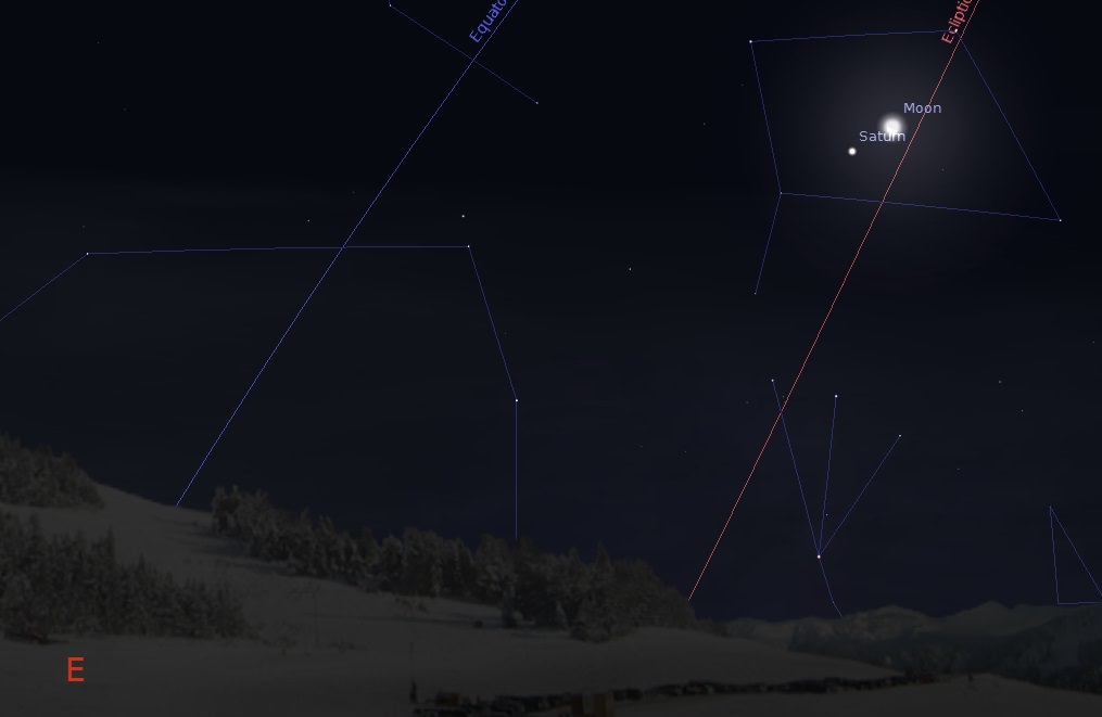
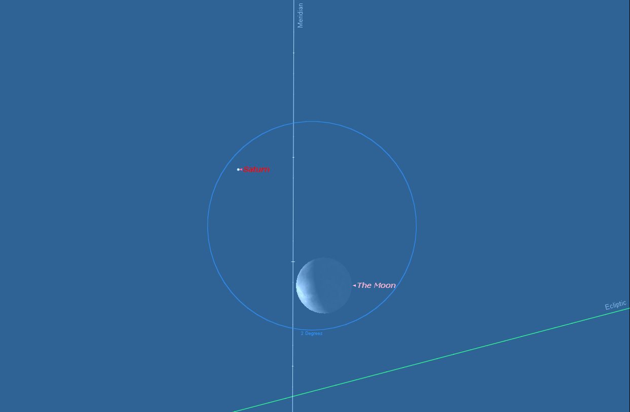
Unfortunately, the January 25th occultation of Saturn by the Moon will only grace part of Antarctica, southern Argentina and Chile, and the Falkland Islands post-sunrise. The rest of us still will see a very photogenic pass of Saturn near the waning crescent Moon on the morning of Saturday, January 25th. The Moon will pass just about a degree — two times its apparent width — south of Saturn for northern hemisphere observers.

The footprint for the January 25th occultation of Saturn by the Moon. dashed lines indicate where the events occurs in the daytime sky. (Created using Occult 4.0.11 software)
The footprint for the January 25th occultation of Saturn by the Moon. dashed lines indicate where the events occurs in the daytime sky. (Created using Occult 4.0.11 software)

Both the Moon and Saturn will reside in the astronomical constellation of Libra this weekend during closest passage. The pair will rise around 2 AM local. After their brief tryst, the Moon will head towards New on January 30th while Saturn will continue to rise successively earlier as its heads towards opposition and the start of evening Saturn observing season on May 10th, 2014.

January 2014 is also notable for having two New Moons, an occurrence informally known as a Black Moon. This occurs again this year in March, and February 2014 is devoid of a New Moon. February is the only month that can be “missing a Moon phase” as it’s the only one shorter the synodic period of 29.5 days, in which the Moon returns to like phase.

Saturn as imaged by the author in 2012.

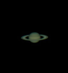
In the telescope, Saturn will present a +0.8 magnitude disk 16” across (38” with rings from tip-to-tip). Saturn’s rings are tipped open to our line of sight by about 22 degrees in 2014, and are widening towards a maximum of 27 degrees in 2016 through 2017. If you have an equatorial telescope with tracking capability, it may be possible this weekend to follow Saturn up into the daytime sky. Though Saturn isn’t quite bright enough to see in the daytime unaided, it might just be possible to spy using binoculars on the 25th using the nearby crescent Moon as a guide.  Saturn is a tough daytime target to be sure, but it’s not impossible to acquire with a little skill and patience.

The current cycle of occultations of Saturn began on December 1st, 2013 and ends on November 22nd, 2014. The cycle will move progressively northward through the year.

The Moon and Saturn put on a repeat performance over almost the same exact location (this time in darkness) on April 17th, 2014, and the best event in the cycle for North America will be the August 31st daytime occultation of Saturn by the waxing crescent Moon.

Now for the wow factor of what you’re seeing. On Saturday morning, the Moon is just over 371,000 kilometres distant, or a little over a light second away. Saturn is over four thousand times more remote at just over 10.1 astronomical units (AUs) distant, which works out to 1.5 billion kilometres, or over 83 light minutes away.  And although the Moon is over a 112 times larger in apparent diameter than Saturn as seen from the Earth, the globe of Saturn is actually over 34 times bigger.

Saturn and the Moon crossing the local meridian shortly after sunset on January 25th. Created using Starry Night Education Software.

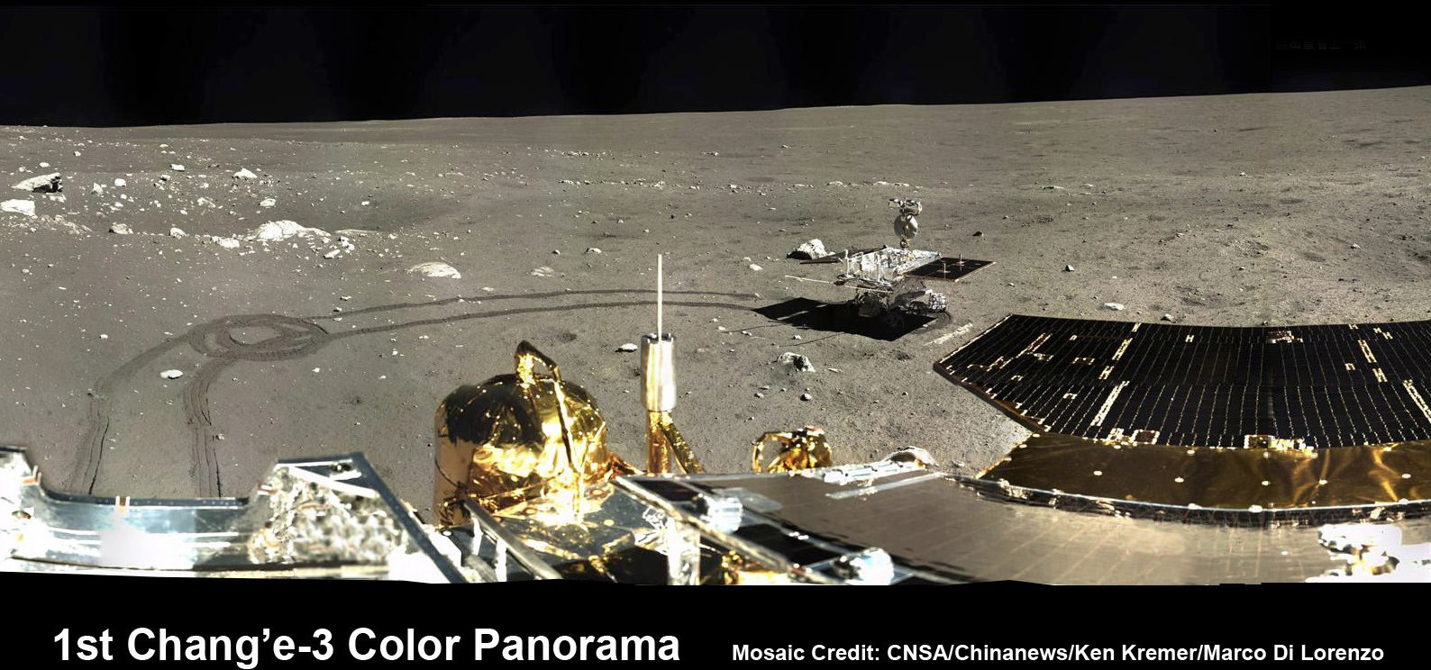
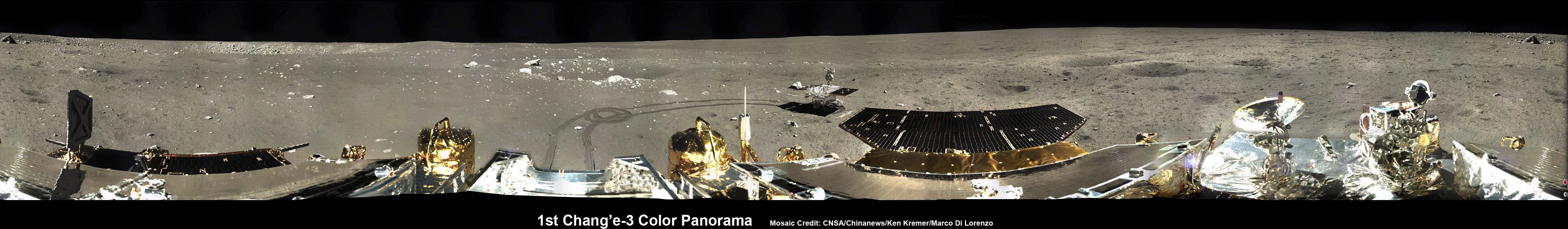
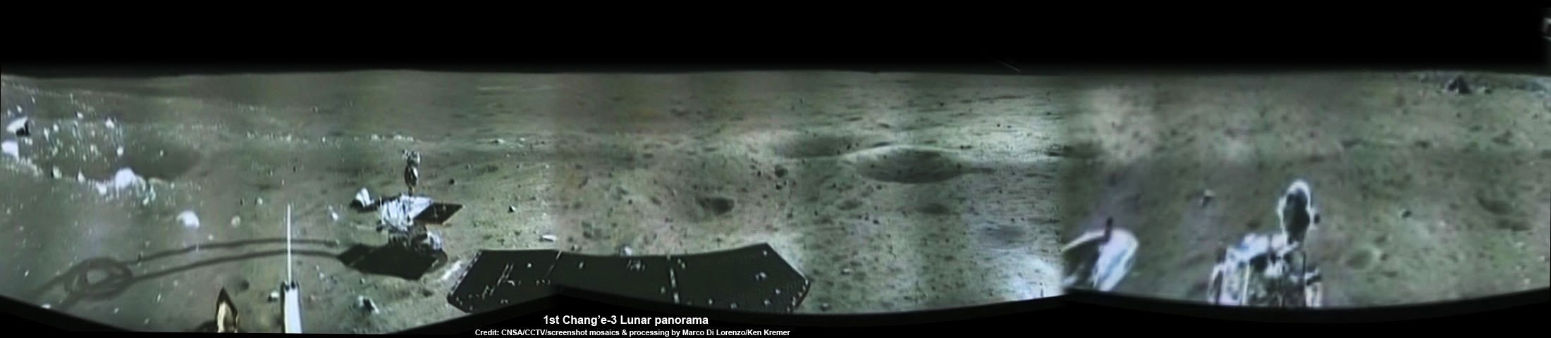
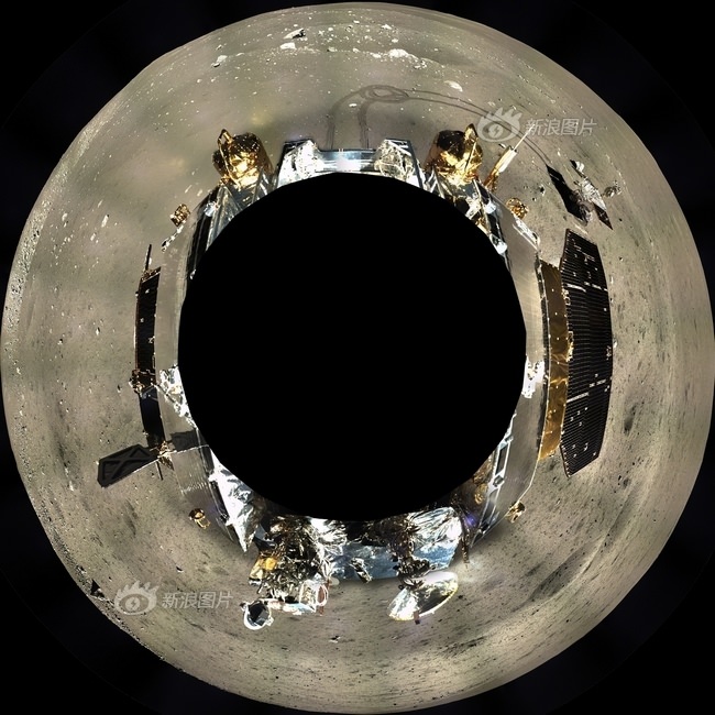
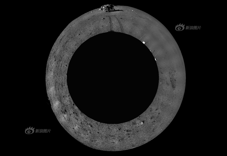
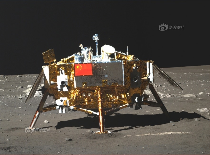
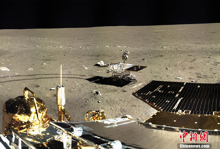
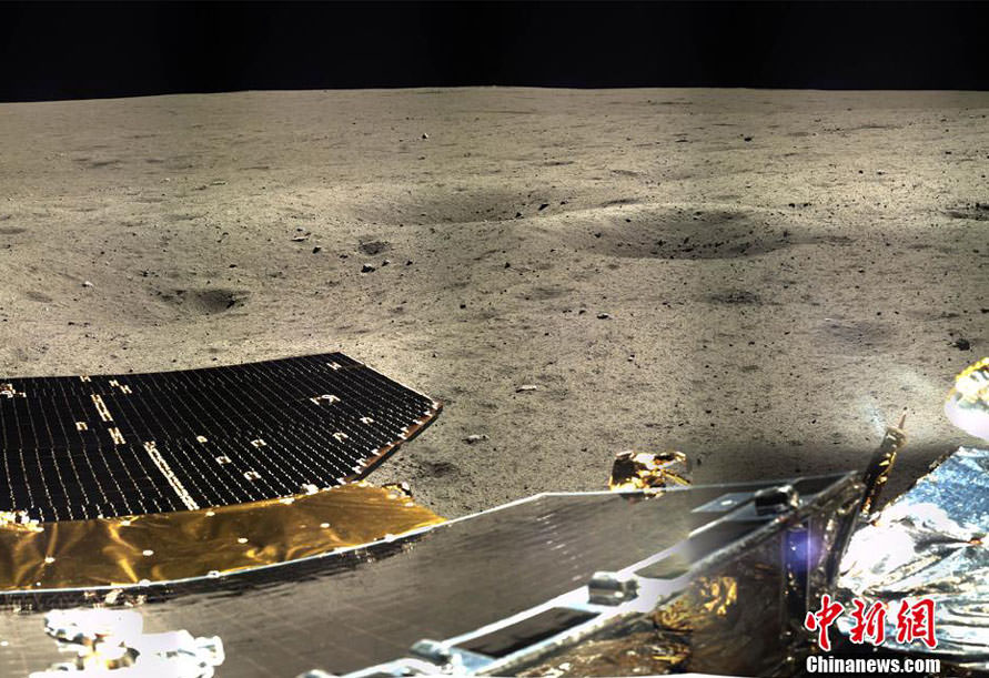
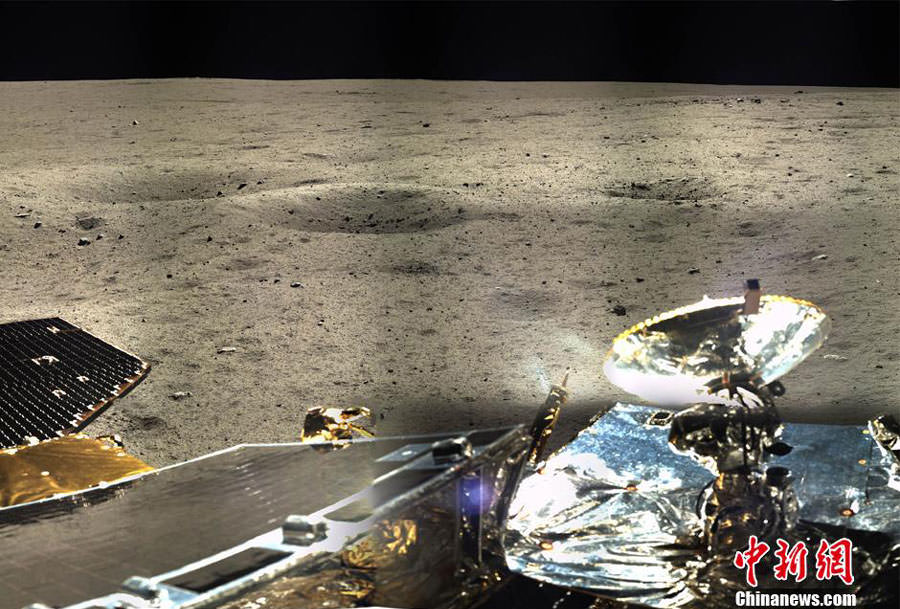
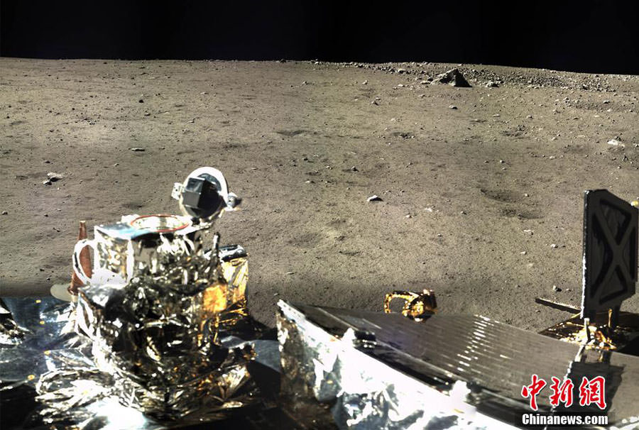
And though we’ve been to the Moon lots since the dawn of the Space Age, only two spacecraft (Voyagers 1 and 2) have made brief flybys of the ringed world, and only one – Cassini – has orbited it. Note that China’s Chang’e-3 lander and rover are about to experience their second sunset this weekend as well from the lunar surface since landing on the Moon last month.

And although lots of planets get occulted by the Moon in 2014, no stars brighter than +1st magnitude lie in its path. In fact, the next cycle of bright star occultations by the Moon doesn’t resume until the Moon meets Aldebaran in January 29th, 2015.

There are, however, over a 100 lesser events involving the Moon occulting naked eye stars worldwide in 2014. Two such events occur this week as well, when the 48% illuminated Moon occults the +4.5th magnitude star Lambda Virginis for west-central South America on the morning of January 24th, and the occultation of the +2.8th magnitude star Alpha Librae  (Zubenelgenubi) for central Asia on January 25th.

Don’t miss these celestial events, and be sure to send those pics in to Universe Today… there’s something for everyone happening in the sky this week worldwide!

Watch Live: ESA Waits for Signal from Comet-Chasing Spacecraft

Rosetta
Rosetta

Watch live streaming video from eurospaceagency at livestream.com

UPDATE: Rosetta woke up! Read our full story about the acquisition of signal here.

For the first time, a spacecraft will follow a comet as it approaches the Sun and land on its nucleus. But today is key to the success of the mission. After nearly two and a half years in hibernation, its time for Rosetta to wake up!

Rosetta has been soaring through the inner solar system for nearly a decade –flying past Mars and Earth several times and even briefly visiting a couple of asteroids. A special ‘hibernation mode’ for the spacecraft was designed by engineers to allow it to survive the large distances from the Sun during its cruise. Since it went into hibernation on June 9, 2011, Rosetta has orbited entirely on its own completely out of contact. But now the Rosetta spacecraft is finally entering the home stretch of its mission to orbit the 4-km-wide comet 67P/Churyumov-Gerasimenko.

Watch live, above, as mission controllers at ESA await for a signal from the spacecraft. The Rosetta mission control team at ESOC is expecting to receive the signal between 17:30-18:30 UTC.
Continue reading “Watch Live: ESA Waits for Signal from Comet-Chasing Spacecraft”

What Is A Solar Sail?

What Is A Solar Sail?

I’m Fraser Cain, and I’m a sailor. Well, okay, I’ve got a sailboat that I take out on the water when its warm and the weather’s nice here on Vancouver Island. I think it’s one of the reasons I absolutely love the idea of a solar sail.

Here’s how they work: Light is made up of photons. Even though they have no mass at rest, they have momentum when they’re moving, well, light speed. When they reflect off a surface, like a mirror or a shiny piece of metal, they impart some of this momentum to that surface. This effect is negligible here on Earth, but out in space, with forces perfectly in balance, that additional momentum can really add up.

A spacecraft flying to Mars gets pushed off course by several thousand kilometers because of light pressure from the Sun.If mission planners didn’t compensate for this drift, their spacecraft would miss the planet, or even worse, crash into it. Even though the total amount of pressure per square meter on a solar sail is minuscule, it’s constantly streaming from the Sun, and it’s totally free….And propulsion that you don’t have to carry with you is the best kind there is.

This is more than just an idea. Solar sails have already been launched and deployed in space. The Japanese Ikaros satellite unfurled a 14-meter solar sail back in 2010. NASA launched its own Nanosail-D spacecraft in 2011. An even bigger solar sail, the Sunjammer, is planned for launch in 2014. The Planetary Society is working on a solar sail project as well.

The closer to the Sun you are, the better they work. In fact, a solar sail would be an ideal vehicle to explore the regions of Mercury and Venus, since they receive so much radiation. But you’re probably wondering how a solar sail could get down to those planets because light is streaming from the Sun in all directions. It’s all about raising and lowering your orbit. If you want to raise your orbit around an object, all you have to do is speed up. And if you want to lower your orbit, you just need to slow down.

A solar sail launched from Earth would start out with the same orbital velocity around the Sun as the Earth. To get into a higher orbit, it tilts the sail so that the light from the Sun speeds it up. And to get into a lower orbit, it tilts in the opposite direction, and the light from the Sun acts like a brake.

Solar Sail.  Image Credit:  NASA
Solar Sail. Image Credit: NASA

A solar sail might even be the ideal spacecraft to make the journey to another star. An interstellar solar sail could lower its orbit so that it’s just above the surface of the Sun. Then, it would unfurl the full sail and capture the most possible photons. A series of powerful laser beams would then target the sail and increase its velocity to a significant fraction of the speed of light.

Of course, you’d need a solar sail thousands of kilometers across, made of a material thinner than a human hair, and lasers putting out more energy than all of humanity. The idea is still intriguing, even though it’s well outside our current technology. Once this technology gets better tested, we’ll to see many more missions employ solar sails as part of their propulsion system.

1st 360 Degree Color Panorama from China’s Chang’e-3 Lunar Lander

1st 360 Degree Color Panorama from China’s Chang’e-3 Lunar Lander. Portion of 1st color panorama from Chang’e-3 lander focuses on the ‘Yutu’ lunar rover and the impressive tracks it left behind after initially rolling all six wheels onto the pockmarked and gray lunar terrain on Dec. 15, 2013. Mosaic Credit: CNSA/Chinanews/Ken Kremer/Marco Di Lorenzo

1st 360 Degree Color Panorama from China’s Chang’e-3 Lunar Lander
Portion of 1st color panorama from Chang’e-3 lander focuses on the ‘Yutu’ lunar rover and the impressive tracks it left behind after initially rolling all six wheels onto the pockmarked and gray lunar terrain on Dec. 15, 2013. Mosaic Credit: CNSA/Chinanews/Ken Kremer/Marco Di Lorenzo
See below – the complete panoramic version as well as a 360 degree interactive version
Will humans follow?[/caption]

Chinese space officials have at last released much higher quality versions of the 1st color imagery captured by China’s first spacecraft to soft land on the surface of the Earth’s Moon; Chang’e-3.

For the enjoyment of space enthusiasts worldwide, we have assembled the newly released imagery to create the ‘1st 360 Degree Color Panorama from China’s Chang’e-3 Lunar Lander.’ See above and below two versions in full resolution, as well as an interactive version – showing the fabulous view on the 1st Lunar Day.

The moonscape panorama shows the magnificent desolation of the pockmarked gray lunar plains at the mission’s touchdown site at Mare Imbrium. It is starkly reminiscent of NASA’s manned Apollo lunar landing missions which took place over 4 decades ago – from 1969 to 1972.

And this spectacular view may well be a harbinger of what’s coming next – as China’s leaders consider a manned lunar landing perhaps a decade hence, details here.

See above a cropped portion – focusing on the piggybacked ‘Yutu’ lunar rover and the impressive tracks it left behind after it initially rolled all six wheels onto the surface; and which cut several centimeters deep into the loose lunar regolith on Dec. 15, 2013.

The beautiful imagery snapped by China’s history making Chang’e-3 lunar lander on 17 and 18 December 2013 – during its 1st Lunar day – was released in six separate pieces on the Chinese language version of the Chinanews website, over the weekend.

See below the compete version of the 360 degree panorama stitched together by the imaging team of scientists Ken Kremer and Marco Di Lorenzo.

1st 360 Degree Color Panorama from China’s Chang’e-3 Lunar Lander. This 1st color panorama from Chang’e-3 lander shows the view all around the landing site after the ‘Yutu’ lunar rover left impressive tracks behind when it initially rolled all six wheels onto the pockmarked and gray lunar terrain on Dec. 15, 2013. Mosaic Credit: CNSA/Chinanews/Ken Kremer/Marco Di Lorenzo – kenkremer.com
1st 360 Degree Color Panorama from China’s Chang’e-3 Lunar Lander
This 1st color panorama from Chang’e-3 lander shows the moonscape view all around the landing site after the ‘Yutu’ lunar rover left impressive tracks behind when it initially rolled all six wheels onto the pockmarked and gray lunar terrain on Dec. 15, 2013. Mosaic Credit: CNSA/Chinanews/Ken Kremer/Marco Di Lorenzo – kenkremer.com

We have also enhanced the imagery to improve contrast, lighting and uniformity to visibly reveal further details.

For comparison, below is the initial black and white panoramic version seen by the landers navigation camera – which we assembled from screenshots taken as it was twirling about in a CCTV news video report.

1st panorama around Chang’e-3 landing site after China’s Yutu rover drove onto the Moon’s surface on Dec. 15, 2013. The images were taken by Chang’e-3 lander following Dec. 14 touchdown. Panoramic view was created from screen shots of a news video assembled into a mosaic. Credit: CNSA/CCTV/screenshot mosaics & processing by Marco Di Lorenzo/Ken Kremer

Alas, one bit of sad news is that it appears the 1200 kg lander’s color camera apparently did not survive the 1st frigid night since it reportedly wasn’t protected by a heater.

For a collection of new and higher quality Chang’e-3 mission photos – including the 1st portraits of the Earth taken from the Moon’s surface in some 40 years – please check my recent article; here.

Check this link – to view a 360 degree interactive version of the first Chang’e-3 color panorama – created by space enthusiast Andrew Bodrov. He has added in a separate image of the Earth snapped by the lander.

China’s action to release higher quality imagery is long overdue and something I have urged the Chinese government to do on several occasions here so that everyone can marvel at the magnitude of China’s momentous space feat.

We applaud the China National Space Administration (CNSA) for this new release and hope they will publish the higher resolution digital versions of all the imagery taken by the Chang’e-3 mothership and the Yutu rover and place everything onto a dedicated mission website – just as NASA does.

Here’s the pair of polar views of the 360 degree lunar landing site panoramas (released last week) – taken by each spacecraft and showing portraits of each other.

This digitally-combined polar panorama shows a 360 degree color view of the moonscape around the Chang’e-3 lander after the Yutu moon rover drove onto the lunar surface leaving visible tracks behind.  Images were taken from Dec. 17 to Dec. 18, 2013.  Credit: Chinese Academy of Sciences
This digitally-combined polar panorama shows a 360 degree color view of the moonscape around the Chang’e-3 lander after the Yutu moon rover drove onto the lunar surface leaving visible tracks behind. Images were taken from Dec. 17 to Dec. 18, 2013. Credit: Chinese Academy of Sciences
This digitally-combined polar panorama shows a 360 degree black and white view of the moonscape around the Yutu moon rover after it drove off the Chang’e-3 lander at top and left visible tracks behind.  Images were taken on Dec. 23, 2013.  Credit: Chinese Academy of Sciences
This digitally-combined polar panorama shows a 360 degree black and white view of the moonscape around the Yutu moon rover after it drove off the Chang’e-3 lander at top and left visible tracks behind. Images were taken on Dec. 23, 2013. Credit: Chinese Academy of Sciences

China’s history making moon robots – the Chang’e-3 lander and Yutu rover – are now working during their 2nd Lunar Day. They have resumed full operation – marking a major milestone in the new mission.

It’s remarkable to consider that although they were just awoken last weekend on Jan. 11 and Jan. 12 from the forced slumber of survival during their long frigid 1st lunar night, they are now already half way through Lunar Day 2 – since each day and night period on the Moon lasts two weeks.

Photo of Chang'e-3 moon lander emblazoned with Chinese national flag taken by the panoramic camera on the Yutu moon rover on Dec. 22, 2013. Credit: CNSA
Photo of Chang’e-3 moon lander emblazoned with Chinese national flag taken by the panoramic camera on the Yutu moon rover on Dec. 22, 2013. Credit: CNSA

China is only the 3rd country in the world to successfully soft land a spacecraft on Earth’s nearest neighbor after the United States and the Soviet Union.

Meanwhile as China’s Yutu rover trundles across pitted moonscapes, NASA’s Opportunity rover is in the midst of Martian mountaineering at the start of Decade 2 on the Red Planet and younger sister Curiosity is speeding towards the sedimentary layers of Mount Sharp.

Stay tuned here for Ken’s continuing Chang’e-3, Orbital Sciences, SpaceX, commercial space, LADEE, Mars and more news.

Ken Kremer

Opportunity Rover Starts 2nd Decade by Spectacular Mountain Summit and Mineral Goldmine

Opportunity by Solander Point peak – 2nd Mars Decade Starts here! NASA’s Opportunity rover captured this panoramic mosaic on Dec. 10, 2013 (Sol 3512) near the summit of “Solander Point” on the western rim of Endeavour Crater where she starts Decade 2 on the Red Planet. She is currently investigating outcrops of potential clay minerals formed in liquid water on her 1st mountain climbing adventure. Assembled from Sol 3512 navcam raw images. Credit: NASA/JPL/Cornell/Marco Di Lorenzo/Ken Kremer-kenkremer.com

Opportunity by Solander Point peak – 2nd Mars Decade Starts here!
NASA’s Opportunity rover captured this panoramic mosaic on Dec. 10, 2013 (Sol 3512) near the summit of “Solander Point” on the western rim of Endeavour Crater where she starts Decade 2 on the Red Planet. She is currently investigating outcrops of potential clay minerals formed in liquid water on her 1st mountain climbing adventure. Assembled from Sol 3512 navcam raw images. Credit: NASA/JPL/Cornell/Marco Di Lorenzo/Ken Kremer-kenkremer.com
See full mosaic with Dust Devil and 10 Year Route Map – below
Story updated[/caption]

NASA’s long-lived Opportunity Mars rover has accomplished what absolutely no one expected.

Opportunity is about to embark on her 2nd decade exploring the Red Planet since her nail biting touchdown in 2004.

And to top that off she is marking that miraculous milestone at a spectacular outlook by the summit of the first mountain she has ever scaled!

See our Solander Point summit mosaic showing the robots current panoramic view – in essence this is what her eyes see today; above and below.

And that mountaintop is riven with outcrops of minerals that likely formed in flowing liquid neutral water conducive to life – potentially a scientific goldmine.

“We expect we will reach some of the oldest rocks we have seen with this rover — a glimpse back into the ancient past of Mars,” says the rover principal investigator, Steve Squyres of Cornell University, Ithaca, N.Y.

“It’s like starting a whole new mission.”

Back on sol 3365 we took this image of Solander Point as we approached it. Here I have plotted the subsequent route that Opportunity has taken in climbing up the ridge. The outcrop shown I the images below are near the end of the yellow traverse line.  Caption and mosaic by Larry Crumpler/NASA/JPL/
Back on sol 3365 we took this image of Solander Point as we approached it. Here I have plotted the subsequent route that Opportunity has taken in climbing up the ridge. The outcrop shown I the images below are near the end of the yellow traverse line. Caption and mosaic by Larry Crumpler/NASA/JPL

Opportunity is nearly at the peak of Solander Point, an eroded segment on the western flank of vast Endeavour Crater, that spans some 22 kilometers (14 miles) in diameter.

The six wheeled rover reached the top section of Solander on Sol 3512, just before Christmas in December 2013. It’s situated nearly 40 meters (130 feet) above the crater plains.

There she began inspecting and analyzing an area of exposed outcrops called ‘Cape Darby’ that scientists believe holds caches of clay minerals which form in drinkable water and would constitute a habitable zone.

Opportunity by Solander Point peak – 2nd Mars Decade Starts here!  NASA’s Opportunity rover captured this panoramic mosaic on Dec. 10, 2013 (Sol 3512) near the summit of “Solander Point” on the western rim of vast Endeavour Crater where she starts Decade 2 on the Red Planet. She is currently investigating summit outcrops of potential clay minerals formed in liquid water on her 1st mountain climbing adventure. See wheel tracks at center and dust devil at right. Assembled from Sol 3512 navcam raw images. Credit: NASA/JPL/Cornell/Marco Di Lorenzo/Ken Kremer-kenkremer.com
Opportunity by Solander Point peak – 2nd Mars Decade Starts here!
NASA’s Opportunity rover captured this panoramic mosaic on Dec. 10, 2013 (Sol 3512) near the summit of “Solander Point” on the western rim of vast Endeavour Crater where she starts Decade 2 on the Red Planet. She is currently investigating summit outcrops of potential clay minerals formed in liquid water on her 1st mountain climbing adventure. See wheel tracks at center and dust devil at right. Assembled from Sol 3512 navcam raw images.
Credit: NASA/JPL/Cornell/Marco Di Lorenzo/Ken Kremer-kenkremer.com

The science team directed Opportunity to ‘Cape Darby’ based on predictions from spectral observations collected from the CRISM spectrometer aboard one of NASA’s spacecraft circling overhead the Red Planet – the powerful Mars Reconnaissance Orbiter (MRO).

Opportunity is using all its cameras and instruments as well as those on the robotic arm to inspect the outcrop area, including the rock abrasion tool, spectrometers and microscopic imager.

As reported earlier this week, the rover is also investigating a mysterious rock that suddenly appeared in images nearby the robot. ‘Pinnacle Island’ rock may have been flung up by the wheels. No one knows for sure – yet.

Mosaic of Opportunity and mysterious Pinnacle Island rock by Solander Point peak.  Mysterious Pinnacle Island rock suddenly appeared out of nowhere in images snapped on Sol 3540.  It was absent in earlier images on Sol 3528.  This mosaic shows the rock nearby the solar panels of NASA’s Opportunity rover.  Assembled from Sol 3528 and 3540 pancam raw images.  Credit: NASA/JPL/Cornell/Marco Di Lorenzo/Ken Kremer-kenkremer.com
Mosaic of Opportunity and mysterious Pinnacle Island rock by Solander Point peak. Mysterious Pinnacle Island rock suddenly appeared out of nowhere in images snapped on Sol 3540. It was absent in earlier images on Sol 3528. This mosaic shows the rock nearby the solar panels of NASA’s Opportunity rover. Assembled from Sol 3528 and 3540 pancam raw images. Credit: NASA/JPL/Cornell/Marco Di Lorenzo/Ken Kremer-kenkremer.com

Solander Point is the first mountain she has ever climbed along her epic 10 year journey across the plains of Meridiani. Heretofore she toured a string of Martian craters. See 10 Years Route map below.

In mid-2013, the scientists used similar orbital observations to find a rock called “Esperance’ – which was loaded with clay minerals and located along another Endeavour crater rim segment called Cape York.

Squyres ranked “Esperance” as one of the “Top 5 discoveries of the mission.”

The team hopes for similar mineralogical discoveries at Solander.

The northward-facing slopes at Solander also afford another major benefit to Opportunity. They will tilt the rover’s solar panels toward the sun in the southern-hemisphere winter sky thereby providing an important energy boost.

The power boost will enable continued mobile operations through the upcoming frigidly harsh winter- her 6th since landing 10 years ago.

Opportunity rover’s 1st mountain climbing goal is dead ahead in this up close view of Solander Point at Endeavour Crater. Opportunity has ascended the mountain looking for clues indicative of a Martian habitable environment. This navcam panoramic mosaic was assembled from raw images taken on Sol 3385 (Aug 2, 2013).  Credit: NASA/JPL/Cornell/Marco Di Lorenzo/Ken Kremer (kenkremer.com)
Opportunity rover’s 1st mountain climbing goal is dead ahead in this up close view of Solander Point at Endeavour Crater. Opportunity has ascended the mountain looking for clues indicative of a Martian habitable environment. This navcam panoramic mosaic was assembled from raw images taken on Sol 3385 (Aug 2, 2013). Credit: NASA/JPL/Cornell/Marco Di Lorenzo/Ken Kremer (kenkremer.com)

So Opportunity will be moving from outcrop to outcrop around the summit during the Martian winter. Daily sunshine reaches a minimum in February 2014.

As of Wednesday, Jan. 15, 2014, or Sol 3547, the solar array energy production on the rover is 353 watt-hours, compared to 900 watt-hours after landing. But that is sufficient to keep moving and actively conduct research throughout the winter at the mountaintop.

Opportunity’s long and winding road on the Red Planet began when she safely settled upon the alien world on 24 January 2004, following a harrowing plummet through the thin Martian atmosphere and an airbag assisted, bouncing ball landing.

She arrived barely 3 weeks after her twin sister, Spirit on 3 January 2004.

Today marks Opportunity’s 3551st Sol or Martian Day roving Mars – for what was expected to be only a 90 Sol mission.

So far she has snapped over 188,100 amazing images on the first overland expedition across the Red Planet.

Her total odometry stands at over 24.07 miles (38.73 kilometers) since touchdown on Jan. 24, 2004 at Meridiani Planum.

Read more about sister Spirit – here and here.

Meanwhile on the opposite side of Mars, Opportunity’s younger sister rover Curiosity is trekking towards gigantic Mount Sharp. She celebrated 500 Sols on Mars on New Years Day 2014.

And a pair of new orbiters are streaking to the Red Planet to fortify the Terran fleet- NASA’s MAVEN and India’s MOM.

Finally, China’s Yutu rover is trundling across pitted moonscapes.

Stay tuned here for Ken’s continuing Opportunity, Curiosity, Chang’e-3, LADEE, MAVEN, Mars rover and MOM news.

Ken Kremer

Opportunity starts scaling Solander Point  See the tilted terrain and rover tracks in this look-back mosaic view from Solander Point peering across the vast expanse of huge Endeavour Crater.  Moasic assembled from navcam raw images taken on Sol 3431 (Sept.18, 2013).  Credit: NASA/JPL/Cornell/Marco Di Lorenzo/Ken Kremer - kenkremer.com
Opportunity starts scaling Solander Point
See the tilted terrain and rover tracks in this look-back mosaic view from Solander Point peering across the vast expanse of huge Endeavour Crater. Moasic assembled from navcam raw images taken on Sol 3431 (Sept.18, 2013). Credit: NASA/JPL/Cornell/Marco Di Lorenzo/Ken Kremer – kenkremer.com
Traverse Map for NASA’s Opportunity rover from 2004 to 2014.  This map shows the entire path the rover has driven during a decade on Mars and over 3540 Sols, or Martian days, since landing inside Eagle Crater on Jan 24, 2004 to current location by f Solander Point summit at the western rim of Endeavour Crater.  Rover will spnd 6th winter here atop Solander.  Opportunity discovered clay minerals at Esperance - indicative of a habitable zone.  Credit: NASA/JPL/Cornell/ASU/Marco Di Lorenzo/Ken Kremer
Traverse Map for NASA’s Opportunity rover from 2004 to 2014 – A Decade on Mars
This map shows the entire path the rover has driven during a decade on Mars and over 3552 Sols, or Martian days, since landing inside Eagle Crater on Jan 24, 2004 to current location by f Solander Point summit at the western rim of Endeavour Crater. Rover will spnd 6th winter here atop Solander. Opportunity discovered clay minerals at Esperance – indicative of a habitable zone. Credit: NASA/JPL/Cornell/ASU/Marco Di Lorenzo/Ken Kremer

Wake Up, Rosetta!

Artist's impression (not to scale) of the Rosetta orbiter deploying the Philae lander to comet 67P/Churyumov–Gerasimenko. Credit: ESA–C. Carreau/ATG medialab.


It’s being called “the most important alarm clock in the Solar System” —  this Monday, January 20, at 10:00 GMT (which is 5:00 a.m. for U.S. East Coasters like me) the wake-up call will ring on ESA’s Rosetta spacecraft, bringing it out of hibernation after over two and a half years in preparation of its upcoming and highly-anticipated rendezvous with a comet.

The wake-up will incite the warming of Rosetta’s star trackers, which allow it to determine its orientation in space. Six hours later its thrusters will fire to stop its slow rotation and ensure that its solar arrays are receiving the right amount of sunlight. Using its thawed-out star trackers Rosetta will aim its transmitter towards Earth and, from 500 million miles (807 million km) away, will send a thumbs-up signal that everything is OK and it’s time to get back to work.

From that distance the transmission will take 45 minutes to reach us. Rosetta’s first signal is expected between 17:30 – 18:30 GMT (12:30 – 1:30 p.m. ET). Once we’re assured all is well, Rosetta has a very exciting year ahead!

After nearly a decade of soaring through the inner solar system, flying past Mars and Earth several times and even briefly visiting a couple of asteroids (2867 Steins on September 5, 2008 and 21 Lutetia on July 10, 2010) Rosetta is finally entering the home stretch of its mission to orbit the 4-km-wide comet 67P/Churyumov-Gerasimenko.

Once Rosetta enters orbit around the comet — the first time a spacecraft has ever done so — it will map its surface and, three months later in November, deploy the 220-lb (100-kg) Philae lander that will intimately investigate the surface of the nucleus using a suite of advanced science instruments. (Watch a video here of how all this will happen… using Legos!)

Read more: Spider-Like Spacecraft Aims To Touch A Comet Next Year After Rosetta Reactivates

With Philae firmly attached to the comet, Rosetta will follow it around the Sun as it makes its closest pass in August 2015 and then heads back out towards the orbit of Jupiter. Rosetta will provide the most detailed observations ever of a comet’s composition and dramatic evolution as it encounters the heat and energy of our home star.

Of course, before all this can happen Rosetta first has to… WAKE UP! It entered hibernation in July 2011 and has remained silent in a slow spin ever since, with only its computer and some heaters kept running. Waking up from a 31-month nap can’t be easy, so ESA is inviting people around the world to help Wake Up Rosetta (and possibly even win a trip to Germany for the landing in November) by sharing their short movies of how best to awaken a sleeping spacecraft and sharing them to the contest page on Facebook or to Twitter, Vine, or Instagram with the #WakeUpRosetta hashtag.

See more about the contest below:

Video submissions to the Wake Up Rosetta video contest will be accepted until 17:30 GMT on Monday so if you haven’t already, get your cameras out and your imaginations going… this spacecraft isn’t going to wake itself! (Well, actually it kinda is but you can still show off your creativity!)

And even if you don’t send in a video, you can watch the live feed of Monday’s events from ESA starting at 09:15 GMT (4:15 a.m. ET) here and here. (Also follow @ESA_Rosetta on Twitter — currently it’s “still sleeping.”)

Want to find out where Rosetta is right now? Check out this cool interactive map from Daniel Scuka, Senior Editor of Spacecraft Operations at ESOC.

Rosetta launched on March 2, 2004 by an Ariane-5 G+ from Europe’s spaceport in Kourou, French Guiana. Read more on the mission page and the Rosetta blog here.

___________

UPDATE Jan. 20: Rosetta has awoken! This afternoon at 18:18 UTC, after 48 minutes of increasingly tense anticipation, a signal from the spacecraft was received by both NASA’s Deep Space Network in Goldstone, CA and the ground station in Canberra, Australia. Rosetta is up and running and so far seems to be in good condition — Go Rosetta and Philae! Read the full story here.

Chang’e 3 Lander Beams Back New Lunar Panorama Photos

AfricaCredit: Chinanews.com

Little by little we’re getting sharper, clearer pictures from the Chinese Chang’e 3 moon mission. Yesterday the lander beamed back a series of new photos taken with its panoramic camera. Stitched together, they give us a more detailed and colorful look of the rover’s surroundings in northern Mare Imbrium. I’ve ordered the images starting with a nice crisp view of the Yutu rover; from there we turn by degree to the right across the five frames. The final mosaic unfortunately doesn’t have the resolution yet of the other images. Perhaps one will be published soon.

The lander's solar panels stand out in the foreground with a smattering of small craters nearby. Credit: Chinanews.com
The lander’s solar panels stand out in the foreground with a smattering of small craters nearby. Credit: Chinanews.com
Right of the rover we see more panels and a radio communications dish. Credit: Chinanews.com
A larger crater surrounded by what appears to be excavated impact ejecta is visible near the horizon at upper right. Credit: Chinanews.com
Yutu's tracks stand out in this final image. Credit: Chinanews.com
Yutu’s tracks and another crater with ejecta stand out in this final image. Credit: Chinanews.com


Complete, if small, panorama stitched from the single images. Credit: Chinanews.com


One thing that stands out to my eye when looking at the photos is the brown color of the lunar surface soil or regolith. Color images of the moon’s surface by the Apollo astronauts along with  their verbal descriptions indicate a uniform gray color punctuated in rare spots by patches of more colorful soils.

Apollo 15 astronauts salutes next to the American flag in 1971. The moon's regolith or soil appears a variety of shades of gray. Credit: NASA
Apollo 15 astronauts salutes next to the American flag in 1971. The moon’s regolith or soil appears a variety of shades of gray. Credit: NASA

The famous orange soil scooped up by Apollo 17 astronaut Eugene Cernan comes to mind. Because Apollo visited six different moonscapes – all essentially gray – it makes me wonder if the color balance in the Chinese images might be off. Or did Chang’e 3 just happen to land on browner soils?

The orange soil found by Apollo 17 astronauts really stands out against a uniform gray moonscape. Credit: NASA


Enduring Quests and Daring Visions: NASA Lays Out a Roadmap for Astrophysics

An artist's concept of Kepler-69c, a super-Earth in the habitable zone of a sun-like star.

Three decades ago we were unaware that exoplanets circled other stars. We had just started talking about dark matter but remained blissfully ignorant of dark energy. The Hubble Space Telescope was still on the drawing board and our understanding of the life cycle of stars, the evolution of galaxies, and the history of the Universe was shaky.

But over the past three decades we have discovered thousands of exoplanets around other stars. We have mapped the life cycle of stars from their formation in beautiful stellar nurseries to their sometimes explosive deaths. We have seen deep into the history of the Universe allowing us to paint a picture of galaxies growing from mere shreds to the incredible spiral structures we see today. We now believe dark matter dominates the underlying framework of the Universe, while dark energy drives its accelerating expansion.

The amount of growth over the past three decades has been dramatic. To better access what the next three decades will bring, NASA has laid out a roadmap — a long-term vision for future missions — necessary to advance our understanding of the Universe.

In March 2013, the NASA Advisory Council/Science Committee assembled a group of astronomers who would determine the goals and aims of NASA for the next 30 years. The final product is this so-called roadmap officially titled “Enduring Quests Daring Visions — NASA Astrophysics in the Next Three Decades.”

The roadmap first notes three defining questions NASA should continue to pursue:
— Are we alone?
— How did we get here?
— How does the Universe work?

“Seeking answers to these age-old questions are enduring quests of humankind,” the roadmap states. “The coming decades will see giant strides forward in finding earthlike habitable worlds, in understanding the history of star and galaxy formation and evolution, and in teasing out the fundamental physics of the cosmos.”

In order to better address these questions, the roadmap defines three broad categories of time: the Near-Term Era, defined by missions that are currently flying or planned for this coming decade, the Formative Era, defined by missions that are designed and built in the 2020s, and the Visionary Era, defined by advanced missions for the 2030s and beyond.

Image Credit: NASA 2014
A schematic of the next 30 years subdivided into three decades across the entire electromagnetic spectrum. Image Credit: NASA 2014

Are we alone?

The Near-Term Era’s goal is to develop a comprehensive understanding of the demographics of planetary systems. The Kepler mission has already supplied a plethora of information on hot planets orbiting close to their parent stars. The WFIRST-AFTA mission — a wide-field infrared survey planned to launch in 2024 — will compliment this by supplying information on cold and free-floating planets.

The Formative Era’s goal is to characterize the surfaces and atmospheres of nearby stars. This will allow us to move beyond characterizing planets as Earth-like in mass and radius to truly being Earth-like in planetary and atmospheric composition. A proposed mission that allows a large star-planet contrast will directly measure oxygen, water vapor, and other molecules in the atmospheres of Earth-like exoplanets.

The Visionary Era’s goal is to produce the first resolved images of Earth-like planets around other stars. The roadmap team hopes to identify continents and oceans on distant worlds using optical telescopes orbiting hundreds of kilometers apart.

How did we get here?

The Near-Term Era will use the James Webb Space Telescope to supply unprecedented views of protostars and star clusters. It will resolve nearby stellar nurseries and take a closer look at the earliest galaxies.

The Formative Era will trace the origins of planets, stars and galaxies across a spectrum of wavelengths. An infrared surveyor will resolve protoplanetary disks while an X-ray surveyor will observe supernova remnants and trace how these incredible explosions affected the evolution of galaxies. Gravitational wave detectors will untangle the complicated dance between galaxies and the supermassive black holes at their centers.

The Visionary Era will peer nearly 14 billion years into the past when ultraviolet photons from the first generation of stars and black holes flooded spaced with enough energy to free electrons. The James Webb Space Telescope will provide an extraordinary means to better view this threshold.

How does the Universe work?

The Universe is full of extremes. Conditions created in the first nanoseconds of cosmic time and near the event horizons of black holes cannot be recreated in the lab. But the Near-Term and Formative Era’s goals will be to measure the cosmos with such precision that scientists can probe the underlying physics of cosmic inflation and determine the exact mechanisms driving today’s accelerating expansion.

The Visionary Era may use gravitational wave detectors to detect space-time ripples produced during the early stages of the Universe or map the shadow cast by a black hole’s event horizon.

The past 30 years have shown a dramatic growth in knowledge with unimaginable turns. Even with such a detailed framework laid out for the next 30 years, it’s likely that many missions are currently beyond the edge of the present imagination. The most exciting results will be drawn from the questions we haven’t even thought to ask yet.

And as with any of the recent “roadmaps” that the various divisions throughout NASA have presented, the biggest question will be if the funding will be available to make these missions a reality.

Again, this 110-page read may be found here.

The roadmap team consists of Chryssa Kouveliotou (NASA/MSFC), Eric Agol (University of Washington), Natalie Batalha (NASA/Ames), Jacob Bean (University of Chicago), Misty Bentz (Georgia State University), Neil Cornish (Montana State University), Alan Dressler (The Observatories of the Carnegie Institution for Science), Scott Gaudi (Ohio State University), Olivier Guyon (University of Arizona/Subaru Telescope), Dieter Hartmann (Clemson University), Enectali Figueroa-Feliciano (MIT), Jason Kalirai (STScI/Johns Hopkins University), Michael Niemack (Cornell University), Feryal Ozel (University of Arizona), Christopher Reynolds (University of Maryland), Aki Roberge (NASA/GSFC), Kartik Sheth (National Radio Astronomy Observatory/University of Virginia), Amber Straughn (NASA/GSFC), David Weinberg (Ohio State University), Jonas Zmuidzinas (Caltech/JPL), Brad Peterson (Ohio State University) and Joan Centrella (NASA Headquarters).