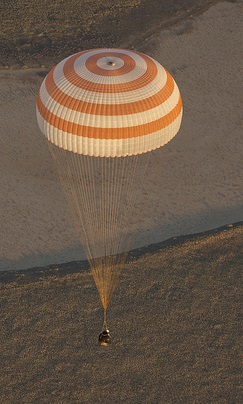
Expedition 37's Fyodor Yurchikhin (Roscosmos), Karen Nyberg (NASA) and Luca Parmitano (European Space Agency) as their Soyuz TMA-09M spacecraft safely descends to Earth on Nov. 10, 2013. Credit: NASA/Carla Cioffi
“It’s only in the moment that you’re in your spacesuit, and that the hatches are closing, that you know that four hours later, you will be back on Earth.”
That’s European Space Agency astronaut Frank De Winne talking about the emotions an astronaut or cosmonaut feels as they leave the International Space Station in a Soyuz spacecraft. The new ESA video, posted above, shows just how hard the astronauts and ground teams have to work to make sure the spacecraft gets to the right spot.
From training, to calculating orbital trajectories, to making sure the landing site in Kazakhstan is free of debris, it’s easy to see how easily those landing teams get up to dozens and dozens of people.
The undocking itself can be complex; depending on which port the Soyuz is attached to, the International Space Station itself may have to change its position to make sure the spacecraft is in the right orientation to head back to Earth.
After navigating the hazards of space, sometimes the landing site can be treacherous as well. In Kazakhstan, the mounds of snow can build up in the area in the winter time; crews need to be prepared to retrieve the spacefarers in just about any weather condition.
With an annual cost of $30.8 million, the Keck Observatory costs $53.7 thousand for a single night’s worth of operation. It will cost the James Webb Space Telescope approximately $8.8 billion to reach orbit. And the Space Launch System that will carry the Orion capsule is expected to cost $38 billion.
Why should we be spending such a vast amount of money on astronomy? How is it useful and beneficial to society?
Astronomers face this question on a daily basis. Recently a ream of European astronomers have provided tangible answers relating advancements in astronomy to advancements in industry, aerospace, energy, medicine, international collaboration, everyday life and humankind.
“I get this question quite often,” Dr. Marissa Rosenberg, lead author on the paper, told Universe Today. “One very personal reason for writing this article is that I wanted to share with my parents (both business people) why what I am doing is important and a necessary facet of society.”
Today, millions of people across the world are affected by advances in astronomy.
Industry
— Your iPhone’s camera is a charge-coupled device (CCD) — an instrument, which converts the movement of electrical charge into a digital value. Originally developed for astronomy, CCD’s are now used in most cameras, webcams and cell phones.
Every iPhone with has a built-in CCD
— The computer language Forth, originally developed for the 36-foot telescope on Kitt Peak is now used by FedEx to track packages.
— AT&T uses IRAF — software written by the National Optical Astronomy Observatory — to analyze computer systems.
— Kodak film, originally created by astronomers studying the sun, is used extensively by the medical and industrial industries, photographers and artists.
Aerospace
— Space-based telescopes have advanced defense satellites, which require identical technology and hardware.
— Global Positioning System satellites rely on astronomical objects — quasars and distant galaxies — to determine accurate positions.
Energy
— Technology gained from imaging X-rays is now used to monitor fusion — where two atomic nuclei combine to form a heavier nucleus — that may prove to be our answer for clean energy.
Medicine
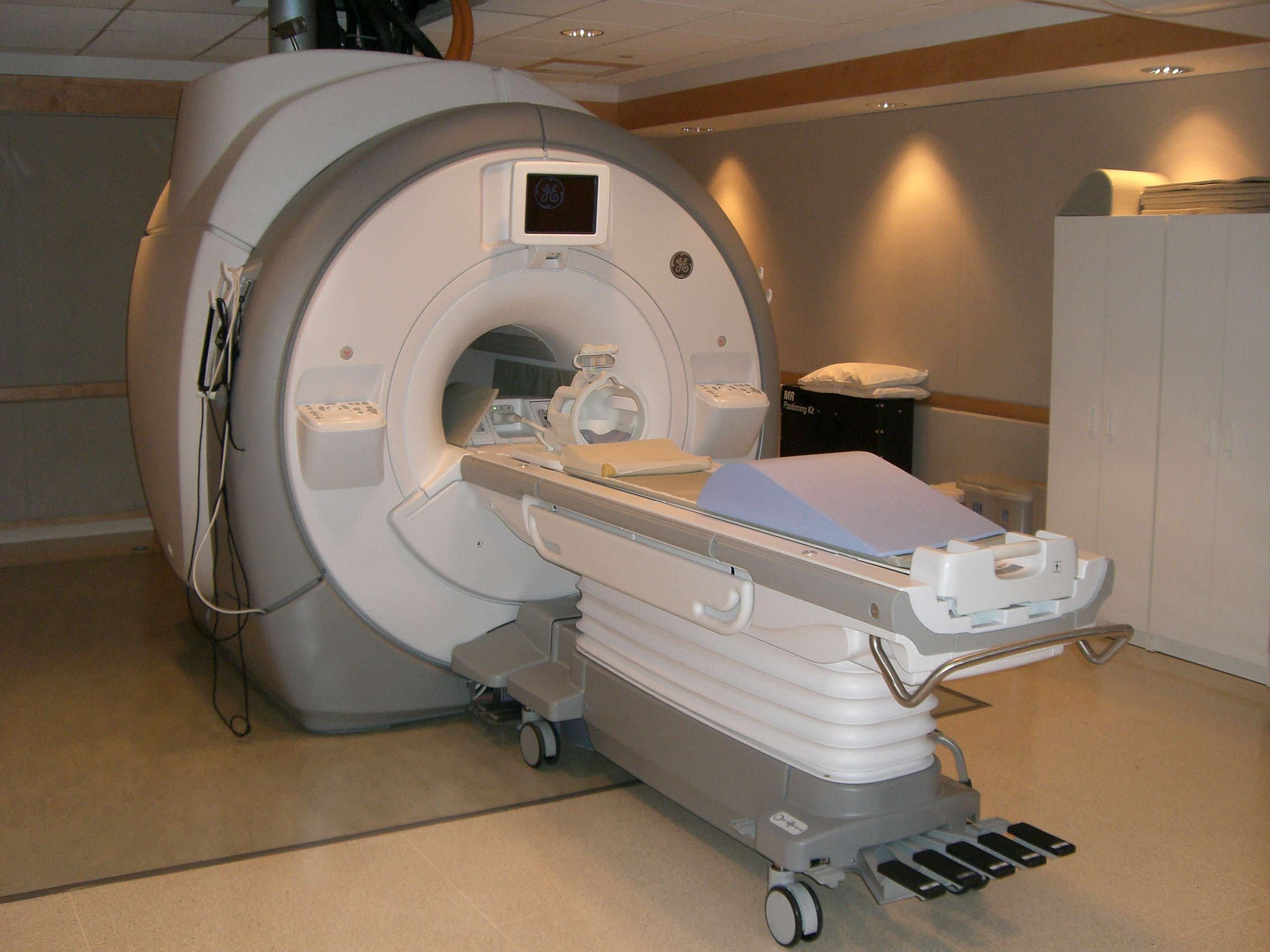
Magnetic resonance imaging utilizes aperture synthesis – first an astronomical technique and now a medical technique.
Astronomy struggles to see increasingly faint objects; Medicine struggles to see things obscured within the human body.
— Aperture synthesis — the process of combining data from multiple telescopes to produce a single image seemingly created from a telescope the size of the entire collection — first developed by a radio astronomer has been used for multiple medical imaging tools, including CAT scanners and MRIs.
— Building space-based telescopes requires an extremely clean environment in order to avoid dust particles from obscuring the mirrors or instruments. Similar methods and instruments are now used in hospitals and pharmaceutical labs.
International Collaboration
— Collaboration also inspires competition. The Space Race — a competition between the Soviet Union and the United States for supremacy in space exploration — landed Neil Armstrong, Michael Collins and Buzz Aldrin on the moon.
— Astronomy is a collaborative effort. In 1887 astronomers from around the world pooled their telescope images in order to create the first map of the entire sky. Today, astronomers travel around the globe to attend conferences, learn from one another, and utilize telescopes elsewhere.
Everyday Life
— Airports utilize advances in technology designed for astronomy. X-ray observatory technology is used in X-ray luggage belts. A gas chromatograph — an instrument designed for a Mars mission — is used to analyze luggage for explosives.
— Stephen Hawking’s “A Brief History of Time” has sold over 10 million copies. Carl Sagan’s television series “Cosmos: A Personal Voyage” has been watched in over 60 countries.
Humankind
“Perhaps the most important reason to study astronomy is that astronomy seeks to satisfy our fundamental curiosity about the world we live in, and answer the ‘big’ questions,” Dr. Rosenberg told Universe Today. “How was the universe created? Where did we come from? Are there other intelligent life forms?”
Every advance in astronomy moves society closer to being able to answer these questions. With advanced technology — increasingly complex CCDs and larger ground- and space-based telescopes — we have peered into the distant, early universe, we have searched for habitable worlds, and we have come to the conclusion that we, ourselves, are stardust.
“Astronomy constantly reminds people of two seemingly contradictory things. First that the universe is infinite and we are of but the tiniest fraction of importance. And Second that life is rare and precious. A home as beautiful and unique as earth does not come often. We must protect it.”
An upcoming version of this paper will not only cover the tangible aspects of astronomy discussed here, but also the intangible aspects of astronomy.
The paper has been accepted has been published on the International Astronomical Union website and is available for download here.
This article was originally written in 2010, but we’ve now updated it and added this spiffy new video.
As you probably know, the Earth is rotating on its axis. This gives us day and night. Of course it’s impossible, but what would happen if the Earth stopped spinning? Remember, this isn’t possible, it can’t happen, so don’t worry.
Everything would be launched in a ballistic trajectory sideways
The first thing to think about is the momentum of everything on the surface of the Earth. You’re held down by gravity and you’re whizzing through space at a rotational velocity of 1,674.4 km/h (at the equator). You can’t feel it because of momentum. Just like how you can’t feel that you’re moving in a car going down the highway. But you feel the effects when you stop, or get into an accident. And so, if the Earth suddenly stopped spinning, everything on the surface of the Earth at the equator would suddenly be moving at more than 1,600 km/hour sideways. The escape velocity of Earth is about 40,000 km/hour, so that isn’t enough to fly off into space; but it would cause some horrible damage as everything flew in a ballistic trajectory sideways. Imagine the oceans sloshing sideways at 1,600 km/hour.
The rotational velocity of the Earth decreases as you head away from the equator, towards the poles. So as you got further away from the equator, your speed would decrease. If you were standing right on the north or south pole, you’d barely even feel it.
A day would last 365 days
The next problem is that day and night wouldn’t work the same any more. Right now the Earth is rotating on its axis, returning the Sun to the same position every 24 hours. But if the Earth stopped spinning, it would then take 365 days for the Sun to move through the sky and return to the same position. Half of the Earth would be baked for half a year, while the other hemisphere was in darkness. It would get very hot on the sunny side, and very cold in the shadowed side. You can imagine how that would be devastating to plants and animals. We get a hint of this at the poles, where you can experience weeks of permanent night and then weeks of permanent day. But imagine 6 months of night, followed by 6 months of day.
The Earth would become a perfect sphere
This might seem minor compared to the other catastrophes, but the Earth would become an almost perfect sphere. The Earth is currently rotating on its axis, completing one turn approximately every 24 hours. This rotational velocity causes the Earth to bulge out around its equator, turning our planet into an oblate spheroid (a flattened ball). Without this spin, gravity would be able to pull the Earth into a nice perfect sphere. This sounds interesting and probably harmless, but it’s actually a *big* problem. Because of the Earth’s bulge in the middle, the oceans are held out at the equator by 8 km. On perfect sphere Earth, the world’s oceans would redistribute, flooding many regions of the planet with an immense volume of water. We’d end up with a single continent around the middle of the planet, with oceans surrounding the north and south poles.
The Earth would no longer be tilted
The Earth’s tilt is defined by how the planet is rotating compared to the Sun. This axis of rotation defines the Earth’s seasons. But without any rotation, the concept doesn’t make sense any more. There’s still a north pole of the planet, where the radiation from the Sun is at its lowest angle, and an equator, where the light hits most directly. But there would no longer be seasons.
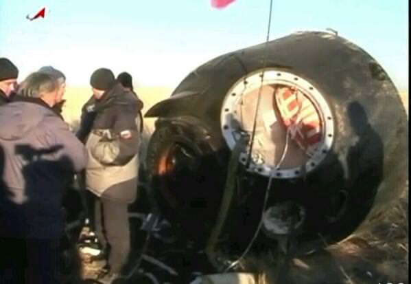
The Soyuz TMA09 on the ground in Kazakhstan after returning home on Nov 11, 2013. Via Twitter.
Expedition 37 crew members Karen Nyberg of NASA, Fyodor Yurchikhin of the Russian Federal Space Agency and Luca Parmitano of the European Space Agency have returned to Earth from the International Space Station, landing at 9:49 p.m. EST Sunday, Nov. 10 (02:49 UTC, 8:49 a.m. Kazakhstan time, Nov. 11), after spending 166 days in space.
The crew brought with them an Olympic torch which was launched to the station Nov. 6 and taken on a spacewalk Saturday as part of the torch relay. The torch was not lit in space, but will be used to light the Olympic flame at the Fisht Stadium in Sochi, Russia, at the start of the 2014 Winter Games in February.
Nyberg, Parmitano and Yurchikhin arrived at the station in May, and during their extended stay in space orbited Earth 2,656 times and traveled more than 112 million km (70 million miles). Parmitano conducted a spacewalk in July, becoming the first Italian to walk in space.
The crew will undergo post-landing medical evaluations and then return to their respective countries.
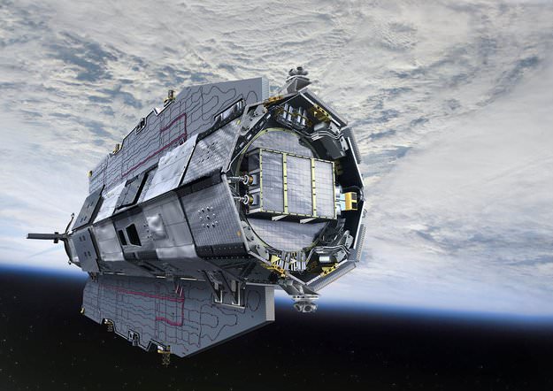
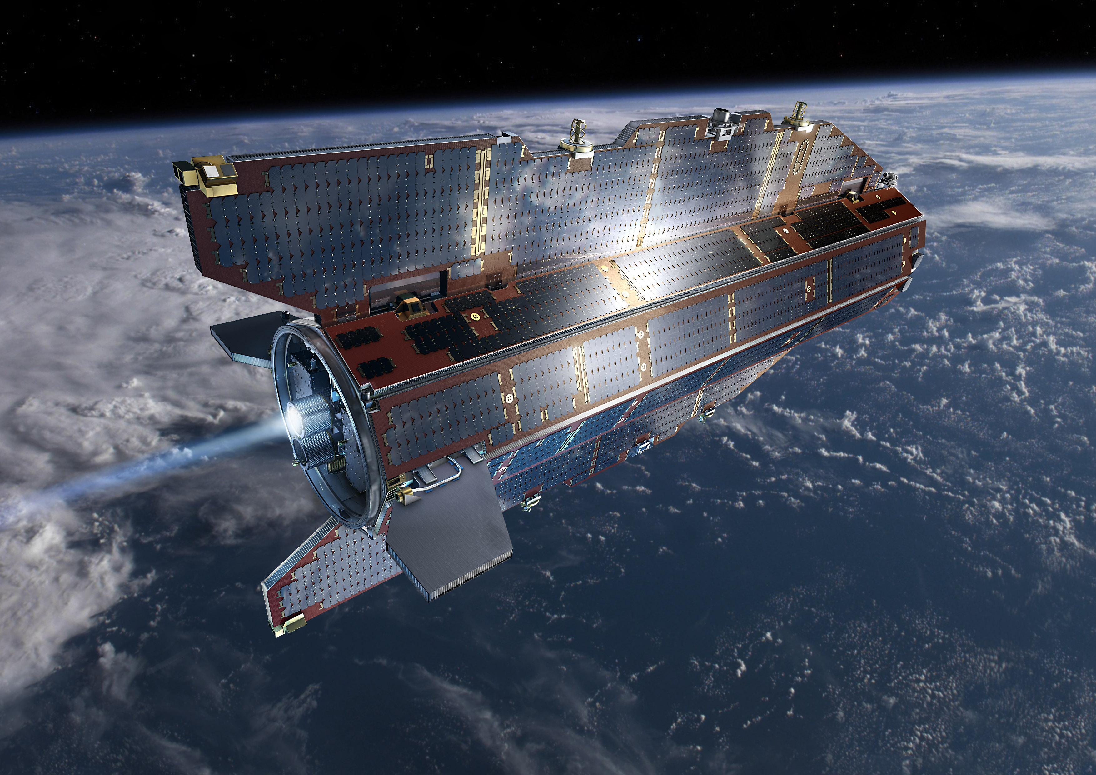
Artist rendition of the GOCE Satellite in orbit. Credit: ESA
ESA’s GOCE satellite has reentered Earth’s atmosphere, with most of the spacecraft disintegrating high in the atmosphere. There have been no reports of damage to property or sightings of debris. Astrophysicist and satellite watcher Jonathan McDowell reported that the spacecraft came down at approximately 00:16 UTC on November 11, 2013 over the South Atlantic Ocean east of Tierra del Fuego – an archipelago off the southernmost tip of the South America.
The last visible sighting of GOCE was at 22:42 UTC on Nov. 10 as it passed 121km (75 miles) above Antarctica, BBC reported.
While most of the 1100 kg satellite disintegrated in the atmosphere, an estimated 25% reached Earth’s surface, likely falling in the ocean.
“The one-ton GOCE satellite is only a small fraction of the 100–150 tons of man-made space objects that reenter Earth’s atmosphere annually,” said Heiner Klinkrad, Head of ESA’s Space Debris Office. “In the 56 years of spaceflight, some 15,000 tons of man-made space objects have reentered the atmosphere without causing a single human injury to date.”
The GOCE spacecraft was designed to fly low and has spent most of its mission roughly 500 km below most other Earth-observing missions, at an altitude of 255 km (158 miles), but has recently been at the lowest altitude of any research satellite at 224 km (139 miles).
Its durable construction and sleek design allowed it to stay in space for longer than expected; it nearly tripled its planned lifetime.
With GOCE data, scientists created the first global high-resolution map of the boundary between Earth’s crust and mantle – called the Moho – and to detect sound waves from the massive earthquake that hit Japan on 11 March 2011, among other results.
Read more about GOCE at ESA.
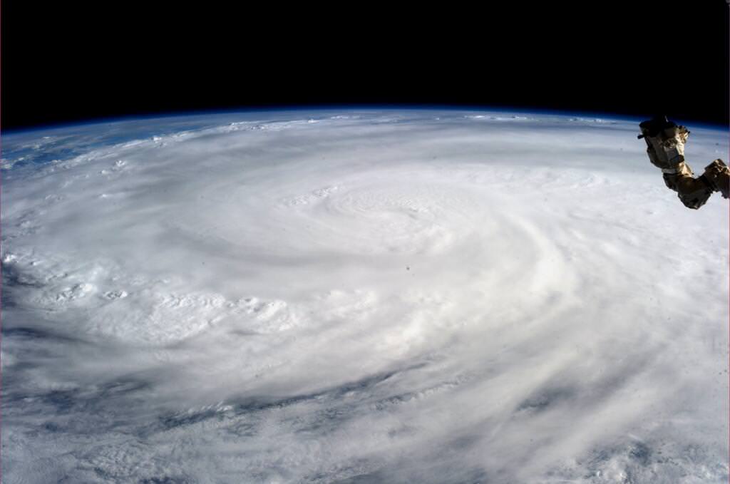
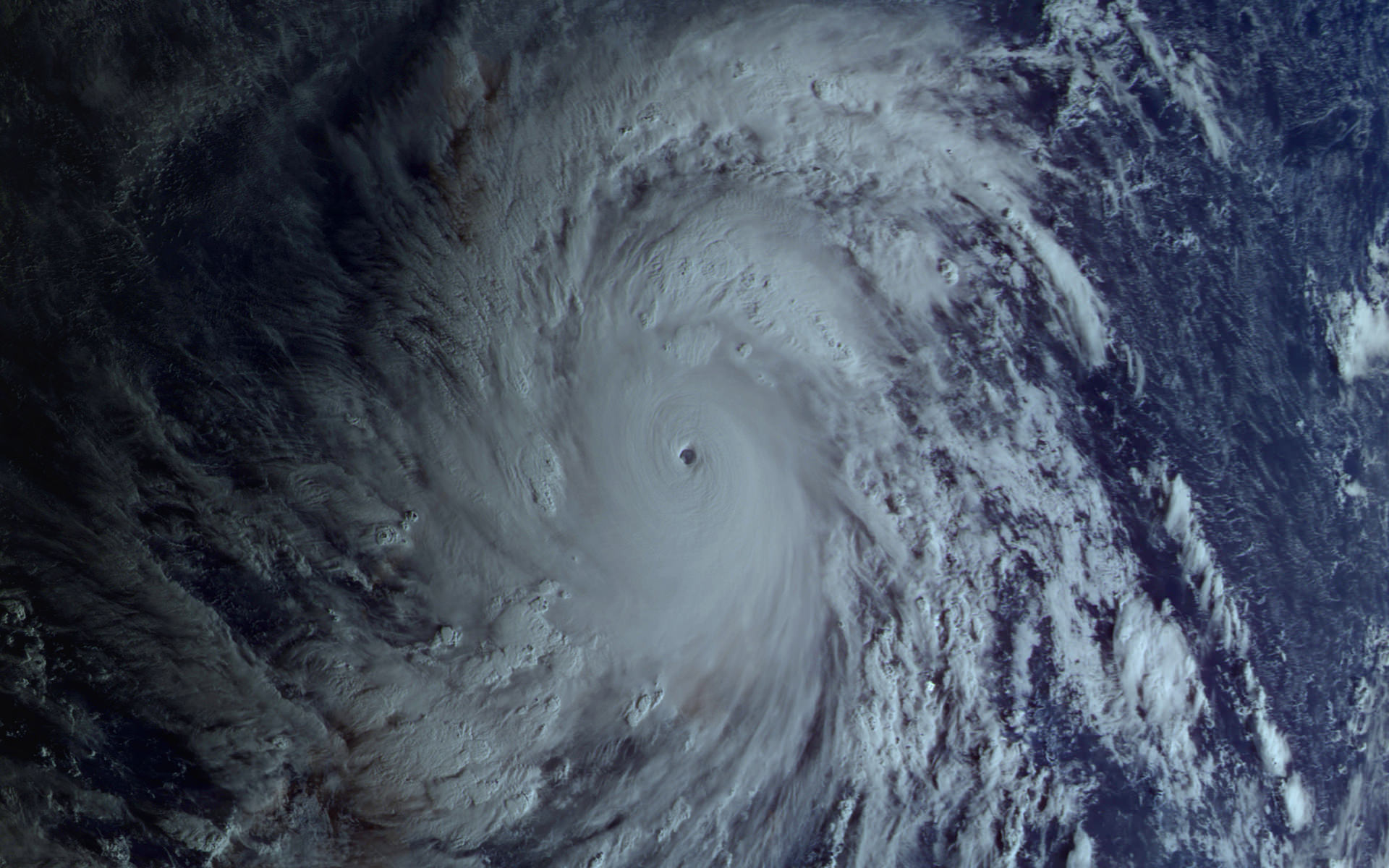
Super Typhoon Haiyan over the Philippines on November 9, 2013 as imaged from Earth orbit by NASA Astronaut Karen Nyberg aboard the International Space Station. Credit: NASA/Karen Nyberg
Super Typhoon Haiyan over the Philippines on November 9, 2013 as imaged from Earth orbit by NASA Astronaut Karen Nyberg aboard the International Space Station.Category 5 killer storm Haiyan stretches across the entire photo from about 250 miles (400 kilometer) altitude. Credit: NASA/Karen Nyberg See more Super Typhoon Haiyan imagery and video below
[/caption]
NASA GODDARD SPACE FLIGHT CENTER, MARYLAND – Super Typhoon Haiyan smashed into the island nation of the Philippines, Friday, Nov. 8, with maximum sustained winds estimated at exceeding 195 MPH (315 kilometer per hour) by the U.S. Navy Joint Typhoon Warning Center – leaving an enormous region of catastrophic death and destruction in its terrible wake.
The Red Cross estimates over 1200 deaths so far. The final toll could be significantly higher. Local media reports today say bodies of men, women and children are now washing on shore.
The enormous scale of Super Typhoon Haiyan can be vividly seen in space imagery captured by NASA, ISRO and Russian satellites – as well as astronaut Karen Nyberg flying overhead on board the International Space Station (ISS); collected here.
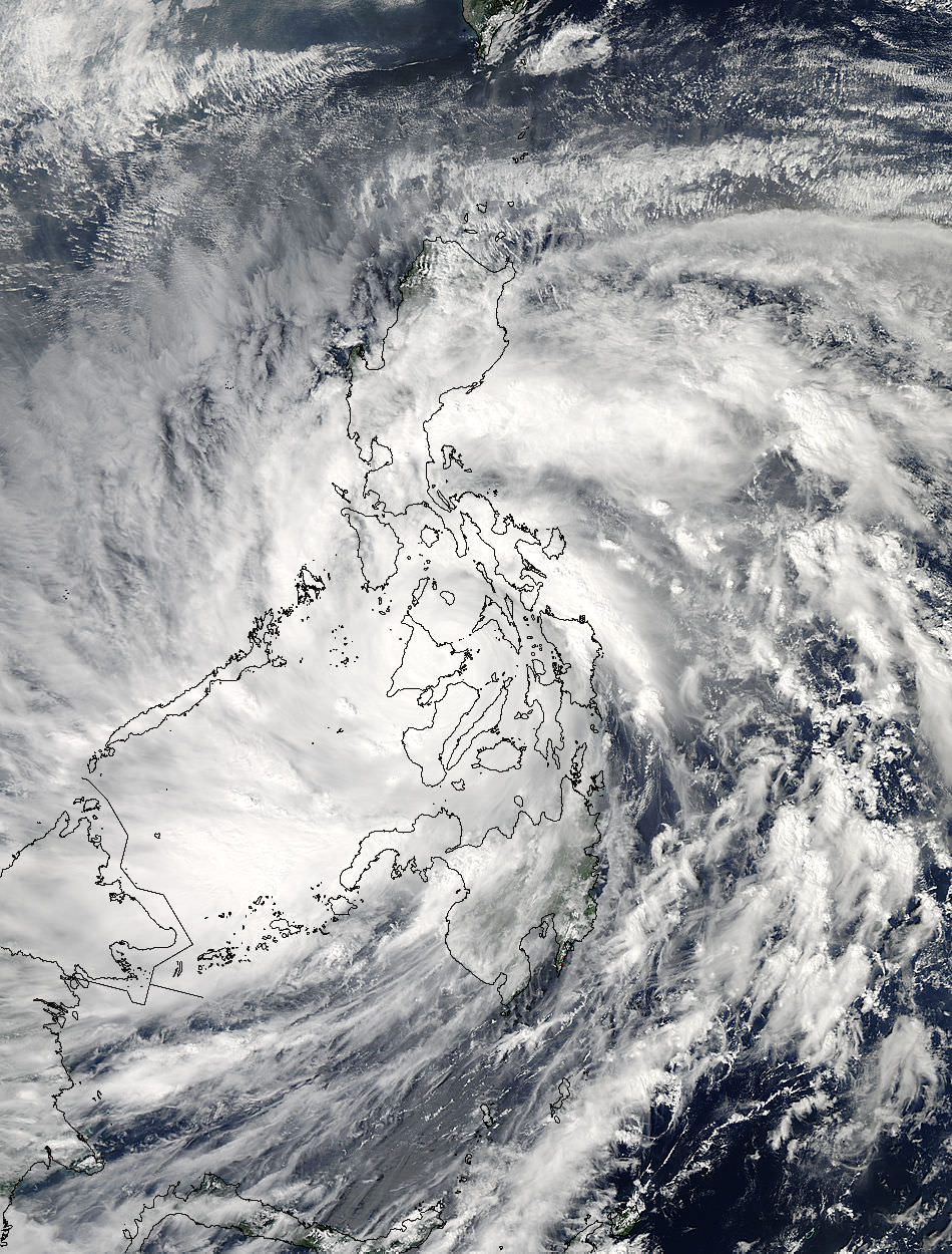
As Super-Typhoon Haiyan moved over the central Philippines on Nov. 8 at 05:10 UTC/12:10 a.m. EDT, the MODIS instrument aboard NASA’s Aqua satellite captured this visible image. Credit: NASA Goddard MODIS Rapid Response Team
Super Typhoon Haiyan is reported to be the largest and most powerful storm ever to make landfall in recorded human history.
Haiyan is classified as a Category 5 monster storm on the U.S. Saffir-Simpson scale.
It struck the central Philippines municipality of Guiuan at the southern tip of the province of Eastern Samar early Friday morning Nov. 8 at 20:45 UTC (4:45 am local time).
As Haiyan hit the central Philippines, NASA says wind gusts exceeded 235 mph (379 kilometers per hour).
The high resolution imagery and precise measurements provided by the worlds constellation of Earth observing space satellites (including NASA, Roscosmos, ISRO, ESA, JAXA) are absolutely essential to tracking killer storms and providing significant advance warning to evacuate residents in affected areas to help minimize the death toll and damage.
More than 800,000 people were evacuated. The storm surge caused waves exceeding 30 feet (10 meters), mudslides and flash flooding.
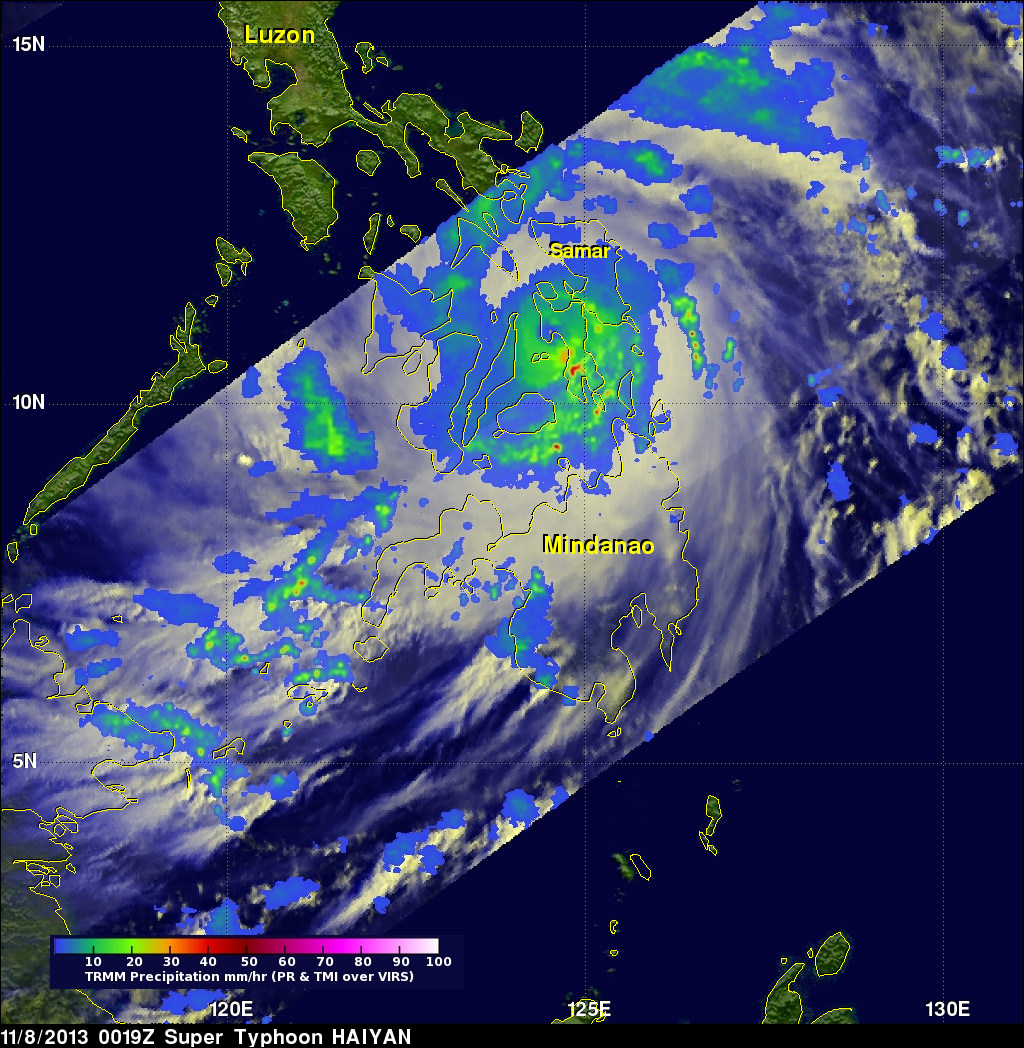
NASA’s Tropical Rainfall Measuring Mission (TRMM) satellite captured visible, microwave and infrared data on the storm just as it was crossing the island of Leyte in the central Philippines, reports NASA – see image below.
NASA’s TRMM satellite data on Nov. 8 at 00:19 UTC showed Haiyan had a well-defined eye surrounded by a symmetric area of moderate rain (green ring with a blue center) with several rainbands wrapping in from the south (green arcs) while crossing the island of Leyte in the central Philippines. Credit: NASA/SSAI, Hal Pierce
TRMM data from rain rates are measured by the TRMM Precipitation Radar (PR) and TRMM Microwave Imager (TMI) and combined with infrared (IR) data from the TRMM Visible Infrared Scanner (VIRS) by science teams working at NASA’s Goddard Space Flight Center in Greenbelt, Md.
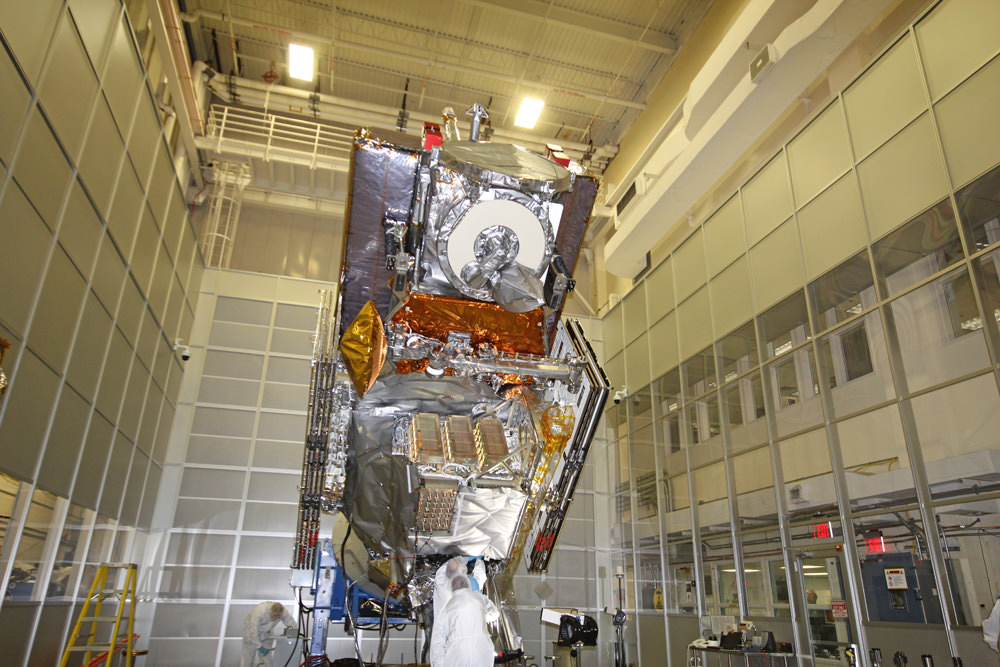
Coincidentally NASA Goddard has just completed assembly of the next generation weather satellite Global Precipitation Measurement (GPM) observatory that replaces TRMM – and where I inspected the GPM satellite inside the Goddard clean room on Friday.
“GPM is a direct follow-up to NASA’s currently orbiting TRMM satellite,” Art Azarbarzin, GPM project manager, told Universe Today during my exclusive clean room inspection of the huge GPM satellite.
NASA’s next generation Global Precipitation Measurement (GPM) observatory inside the clean room at NASA Goddard Space Flight Center. GPM is slated to launch In February 2014 and will provide global measurements of rain and snow every 3 hours – as a direct follow-up to NASA’s currently orbiting TRMM satellite; reaching the end of its usable lifetime.
Credit: Ken Kremer/kenkremer.com
“TRMM is reaching the end of its usable lifetime. GPM launches in February 2014 and we hope it has some overlap with observations from TRMM.”
“The Global Precipitation Measurement (GPM) observatory will provide high resolution global measurements of rain and snow every 3 hours,” Dalia Kirschbaum, GPM research scientist, told me at Goddard.
GPM is equipped with advanced, higher resolution radar instruments. It is vital to continuing the TRMM measurements and will help provide improved forecasts and advance warning of extreme super storms like Hurricane Sandy and Super Typhoon Haiyan, Azarbarzin and Kirschbaum explained.
Video Caption: Super Typhoon Haiyan imaged on Nov 6 – 8, 2013 by the Russian Elektro-L satellite operating in geostationary orbit. Credit: Roscosmos via Vitaliy Egorov
The full magnitude of Haiyan’s destruction is just starting to be assessed as rescue teams reach the devastated areas where winds wantonly ripped apart homes, farms, factories, buildings and structures of every imaginable type vital to everyday human existence.
Typhoon Haiyan is moving westward and is expected to forcefully strike central Vietnam in a day or two. Mass evacuations are underway at this time
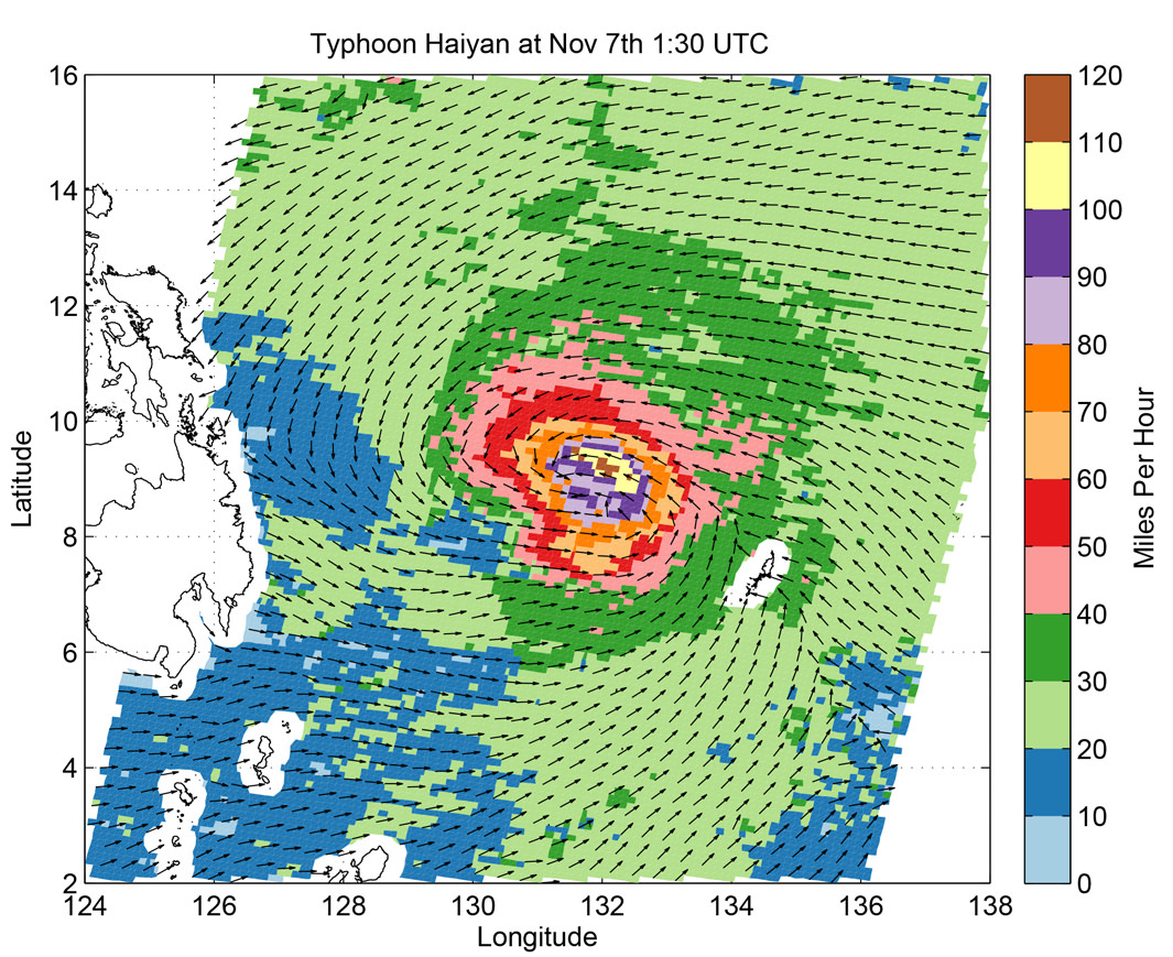
Super Typhoon Haiyan imaged by the Russian Elektro-L satellite operating in geostationary orbit. Credit: Roscosmos via Vitaliy EgorovSuper Typhoon Haiyan’s ocean surface winds were measured by the OSCAT radar scatterometer on the Indian Space Research Organization’s (ISRO) OceanSAT-2 satellite at 5:30 p.m. PST on Nov. 6. The colors indicate wind speed and arrows indicate wind direction. Credit: ISRO/NASA/JPL-Caltech
Artist rendition of the GOCE Satellite in orbit. Credit: ESA
The Gravity field and steady-state Ocean Circulation Explorer (GOCE) satellite has been orbiting Earth in super-low orbits since 2009, mapping out variations in Earth’s gravity in extreme detail. But its fuel ran out in mid-October and the satellite began its slow descent towards Earth, being brought lower and lower by the effects of the atmosphere. Engineers predict it will re-enter completely and fall back to Earth sometime this weekend.
But no one can say for sure when or where the 1-ton satellite will fall.
With no remaining fuel to guide its re-entry there’s no way to nudge or steer its descent. And while most of GOCE is predicted to disintegrate in the atmosphere, several parts might reach Earth’s surface. Experts predict as much as 25% of the spacecraft will survive reentry, as many parts are made of advanced materials, such as carbon-carbon composites.
Today, engineers from the GOCE mission said that the spacecraft is predicted to enter into Earth’s atmosphere sometime during the night between Sunday and Monday, November 10-11, 2013. Break-up of the spacecraft will occur at an altitude of approximately 80 km. “At the moment, the exact time and location of where the fragments will land cannot be foreseen,” says ESA.
The GOCE spacecraft was designed to fly low and has spent most of its mission roughly 500 km below most other Earth-observing missions, at an altitude of 255 km (158 miles), but has recently been at the lowest altitude of any research satellite at 224 km (139 miles).
Its durable construction and sleek design allowed it to stay in space for longer than expected; it nearly tripled its planned lifetime.
With GOCE data, scientists created the first global high-resolution map of the boundary between Earth’s crust and mantle – called the Moho – and to detect sound waves from the massive earthquake that hit Japan on 11 March 2011, among other results.
Heiner Klinkrad, Head of ESA’s Space Debris Office at ESOC, Darmstadt, Germany said that when the spacecraft reaches altitudes below 100 km, then atmospheric density will drastically increase on the spacecraft. It will enter at about 25,000 km/hour, and aerodynamic pressure and heating will cause a break-up of the spacecraft at approximately 80km altitude, causing a large number of fragments.
“The risk to the population on ground will be minute,” said Klinkrad. “Statistically speaking, it is 250,000 times more probable to win the jackpot in the German Lotto than to get hit by a GOCE fragment. In 56 years of space flight, no man-made space objects that have re-entered into Earth’s atmosphere have ever caused injury to humans.”
An international campaign will be monitoring the descent, involving the Inter-Agency Space Debris Coordination Committee. The situation is being continuously watched by ESA’s Space Debris Office, which will issue re-entry predictions and risk assessments.
ESA says they will keep the relevant safety authorities permanently updated.
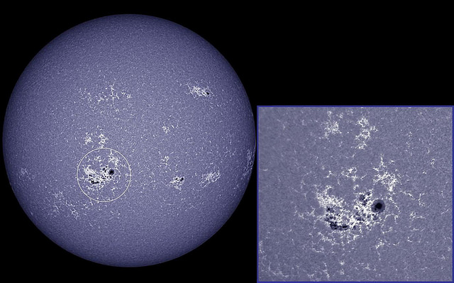
Monster sunspot group 1890 now faces Earth. Taken on Nov. 8, 2013. Credit and copyright: Ron Cottrell.
The Sun is finally acting like it’s in solar maximum. Our Sun has emitted dozens of solar flares in since Oct. 23, 2013, with at least six big X-class flares. Just today it blasted out a X1.1 flare at 04:32 UT (11:32 p.m. EST on Nov. 7, 2013). While old Sol had been fairly quiet for the time where it was supposed to be active in its normal 11-year cycle, only recently has activity ramped up with increased flares and sunspots. During 2013, there has been intermittent strong activity (like this and this in May), but the activity since mid-October is really the first extended period of activity.
Speaking of sunspots, a huge group called designated as AR 1890 has turned to face Earth. Thanks to astrophotographer Ron Cottrell for capturing the group today, above. Spaceweather.com reports that this sunspot has a trend of producing very brief flares. The X1-flare today was no exception as it lasted barely a minute. NOAA is forecasting a 60% chance of M-class solar flares and a 20% chance of X-flares on Nov. 8th from this sunspot group.
You can see an image from the Solar Dynamics Observatory below, as it recorded a flash of extreme UV radiation from the blast site:
NASA’s Solar Dynamics Observatory captured this image of the sun showing an X1.1 class flare that peaked at 11:26 p.m. EST on Nov. 7, 2013. Increased numbers of flares are quite common at the moment as the sun’s normal 11-year activity cycle is ramping up toward solar maximum conditions. Image Credit: NASA/SDO
NASA describes a solar flare as such:
A flare is defined as a sudden, rapid, and intense variation in brightness. A solar flare occurs when magnetic energy that has built up in the solar atmosphere is suddenly released. Radiation is emitted across virtually the entire electromagnetic spectrum, from radio waves at the long wavelength end, through optical emission to x-rays and gamma rays at the short wavelength end. The amount of energy released is the equivalent of millions of 100-megaton hydrogen bombs exploding at the same time.
While solar flares are powerful bursts of radiation, harmful radiation from a flare cannot pass through Earth’s atmosphere to physically affect humans on the ground. But when they are intense enough, they can disturb the atmosphere in the layer where GPS and communications signals travel.
Host: Fraser Cain
Guests: Thad Szabo, Scott Lewis, Ian O’Neill, Alan Boyle, Nancy Atkinson, David Dickinson, Jason Major, Matthew Francis, Nicole Gugliucci