Tracking Comet C/2013 R1 Lovejoy through November

Comet R1 Lovejoy passes the Beehive Cluster: (Credit Damian Peach).

Tired of comets yet? Right now, northern hemisphere observers have four (!) comets within range of binoculars in the dawn sky. Comet C/2012 S1 ISON, is, of course, expected to dazzle towards month’s end. Comet 2P/Encke is an “old standby,” with the shortest orbital period of any comet known at 3.3 years, and is making a favorable appearance this Fall. And comet C/2012 X1 LINEAR added to the morning display recently, reaching about +8th magnitude in an unexpected outburst…

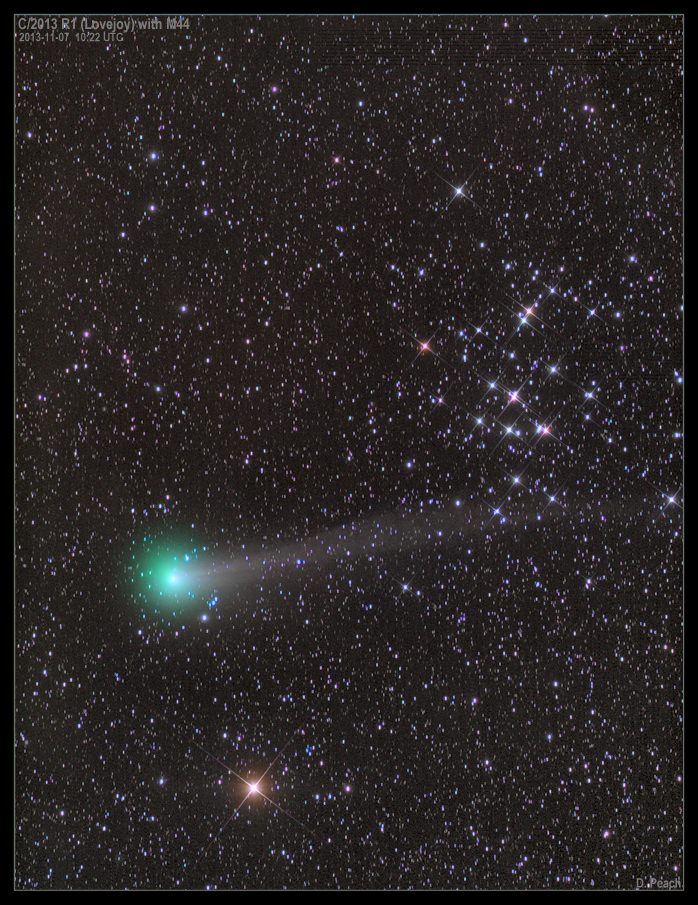
But the brightest and best placed comet for morning viewing is currently Comet C/2013 R1 Lovejoy. Shining at +6th magnitude, R1 Lovejoy just passed into the constellation Leo after a photogenic pass near the Beehive Cluster (M44) in Cancer last week. We caught sight of R1 Lovejoy a few mornings ago, and it’s an easy binocular object, looking like a fuzzy unresolved globular cluster with barely the hint of a tail.

If the name sounds familiar, that’s because the comet was discovered by Australian observer Terry Lovejoy, the prolific discoverer of four comets, including the brilliant sungrazing Comet C/2011 W3 Lovejoy that survived its 140,000 kilometre perihelion passage above the surface of the Sun on December 16th and went on to dazzle southern hemisphere observers in late 2011 and early 2012.

Comet R1 Lovejoy as imaged by Rob Sparks (@HalfAstro) from Tucson, Arizona near the Beehive cluster. (Credit: Rob Sparks).
Comet R1 Lovejoy as imaged by Rob Sparks (@HalfAstro) from Tucson, Arizona passing near the Beehive cluster. (Credit: Rob Sparks).

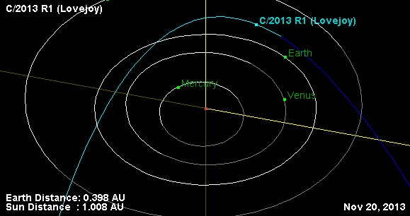
Terry discovered R1 Lovejoy on September 7th, 2013 while it was still at magnitude +14.4. The comet is expected to top out at +4th magnitude in late November as it passes 61.4 million kilometres from Earth on November 19th and heads for perihelion at 0.877 AUs from the Sun on December 25nd, 2013. Comet R1 Lovejoy is on a 64 degree orbit highly inclined to the ecliptic, and has a period roughly 7,000 years long. The last time R1 Lovejoy graced Earthly skies, our early ancestors still thought copper smelting was a pretty hip idea!

The orbital path of Comet R1 Lovejoy through the inner solar system.
The orbital path of Comet R1 Lovejoy through the inner solar system. (Credit: NASA/JPL Solar System Dynamics explorer).

And unlike comets Encke and ISON that are plunging near the Sun, Comet R1 Lovejoy never gets closer than 19 degrees elongation from our nearest star in late December. It also reaches a maximum northern declination of 43 degrees on November 28th, the same day that ISON reaches perihelion. For mid-latitude northern hemisphere observers, R1 Lovejoy will remain well placed at 35 to 45 degrees above the northeastern horizon about an hour before sunrise through late November.

Here are some key dates to aid you in your quest to spy Comet R1 Lovejoy in late November:

November 11th: Passes near +4.5 Kappa Leonis.

November 14th: Passes from Leo into the constellation Leo Minor & passes near the +5.3 star 20 Leonis Minoris.

November 16th: Passes near the +5th magnitude stars 28, 30, and 34 Leonis Minoris.

November 18th: Passes into the constellation Ursa Major.

November 19th: Passes near the +4.8 magnitude star 55 Ursae Majoris & +5.3 magnitude star 57 Ursae Majoris.

November 19th: Closest to Earth, at 0.4 AUs distant.

The celestial path of Comet R1 Lovejoy spanning November 11th to the 30th. (Created using Starry Night Education software).

November 21st: Passes into the constellation Canes Venatici.

November 22nd: Passes near the +6th magnitude star 4 Canum Venaticorum & the +4.2 magnitude star Chara (Beta Canum Venaticorum).

November 24th: Passes near the Sunflower Galaxy (M63).

November 27th: Passes into the constellation Boötes.

December 1st: Passes near +3.5 magnitude star Nekkar (Beta Boötis).

December 4th: crosses into Corona Borealis.

Note that passes on the list above denote passages closer than one degree of Comet R1 Lovejoy near bright objects.

Perihelion for the comet is December 25th at 0.877 AU, and its closest approach to Earth is November 19th. On this date, it will also be moving at its maximum apparent speed as seen from Earth, covering about 3 degrees of the sky every 24 hours, or the angular span of the Full Moon every 4 hours.

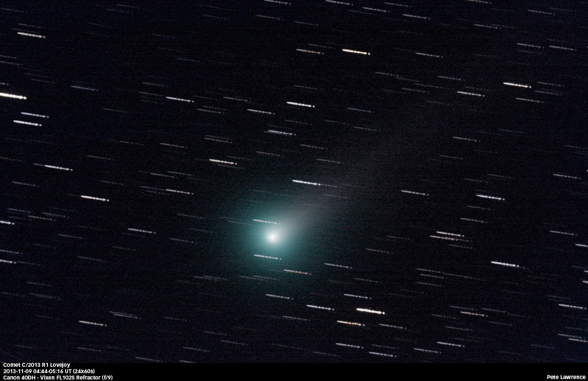
United Kingdom observer Pete Lawrence imaged Comet R1 Lovejoy this past weekend from his backyard garden using a 4-inch apochromatic refractor and a Canon 40D DSLR:

Comet R1 Lovejoy as imaged by Pete Lawrence on November 9th. (Credit: Pete Lawrence).

He also made his first confirmed binocular sighting of Comet ISON using a pair of 15×70 binocs, noting to Universe Today that “ISON’s head appears to be small and stellar compared to Lovejoy’s extended coma, which is obvious in binoculars, and also brighter!”

It’s worth noting that all four of these morning comets are on separate orbital paths, and only seem to be in the same general region of the sky as seen from our Earthly vantage point… and none of them are passing near the Earth!

This week is also a good time to hunt for comets in the pre-dawn sky for another reason: the Moon reaches Full this coming weekend on Sunday, November 17th. After this week, it will start to creep into the morning sky and interfere with deep sky observations for the next two weeks.

Comet R1 Lovejoy imaged on November 10th by astrophtographer Justin Ng. (Credit: Justin Ng).

It’s also interesting to note that amateur observers discovered two more faint comets this past weekend. Though comets C/2013 V3 Nevski and C/2013 V2 Borisov aren’t slated to be anything spectacular, that brings the number of amateur discoveries to 13 for 2013. Are amateur comet hunters mounting a comeback?

In this age of automated surveys, the question is often raised as to whether amateurs can still discover comets. Keep in mind, Terry Lovejoy found Comet R1 Lovejoy with a medium-sized 8-inch Schmidt Cassegrain reflecting telescope… the age of amateur comet hunters seemes far from over in 2013!

Carnival of Space #327

Carnival of Space. Image by Jason Major.

The tent is up! This week’s Carnival of Space is hosted by Pamela Hoffman at the Everyday Spacer blog.

Click here to read Carnival of Space #327.

And if you’re interested in looking back, here’s an archive to all the past Carnivals of Space. If you’ve got a space-related blog, you should really join the carnival. Just email an entry to [email protected], and the next host will link to it. It will help get awareness out there about your writing, help you meet others in the space community – and community is what blogging is all about. And if you really want to help out, sign up to be a host. Send an email to the above address.

How Much Science Data Has The Mars Reconnaissance Orbiter Sent To Earth?

Artist's conception of NASA's Mars Reconnaissance Orbiter. Credit: NASA/JPL

Imagine being able to watch three months’ worth of high-definition space video sequentially — maybe real-time coverage on the International Space Station, or getting to watch the Mars Reconnaissance Orbiter zoom across the Red Planet over and over again. Well, that’s how much science data MRO itself has sent back  in 10 years of operations, NASA said.

“The sheer volume is impressive, but of course what’s most important is what we are learning about our neighboring planet,” stated the Jet Propulsion Laboratory’s Rich Zurek, the project scientist for the Mars Reconnaissance Orbiter.

MRO has sent back 200 terabits, all told. It’s a wealth of science data on its own merits as it examined evidence of water, ancient volcanoes and other parts of the Red Planet’s history from above. The spacecraft, however, also serves as a relay for the NASA Curiosity and Opportunity rovers on the surface.

A crater imaged by the Mars Reconnaissance Orbiter's HiRISE (High Resolution Imaging Science Experiment). Credit: NASA/JPL/University of Arizona
A crater imaged by the Mars Reconnaissance Orbiter’s HiRISE (High Resolution Imaging Science Experiment). Credit: NASA/JPL/University of Arizona

“Data gathered by the orbiter’s instruments and relayed from rovers are recorded onto the orbiter’s central memory. Each orbit around Mars takes the spacecraft about two hours. For part of each orbit, Mars itself usually blocks the communication path to Earth,” NASA stated.

“When Earth is in view, a Deep Space Network antenna on whichever part of Earth is turned toward Mars at that hour can be listening. Complex preparations coordinate scheduling the use of the network’s antennas by all deep-space missions — 32 of them this month. Mars Reconnaissance Orbiter typically gets several sessions every day.”

Once the Deep Space Network antennas in Spain, California and Australia pick up the data, JPL organizes them into their separate “products”, ranging from radar measurements from above to data picked up by a rover below. The information is then sent to various organizations around the world that have interests in the work.

MRO arrived at Mars in 2006 and its mission has been extended three times, with the latest one taking place in 2012. NASA also relays information from the planet using Mars Odyssey, which has been there since 2002.

Source: NASA

Soyuz Spacecraft Landing: ‘The Ultimate Roller-Coaster Ride Back To Earth’

Expedition 37's Fyodor Yurchikhin (Roscosmos), Karen Nyberg (NASA) and Luca Parmitano (European Space Agency) as their Soyuz TMA-09M spacecraft safely descends to Earth on Nov. 10, 2013. Credit: NASA/Carla Cioffi

“It’s only in the moment that you’re in your spacesuit, and that the hatches are closing, that you know that four hours later, you will be back on Earth.”

That’s European Space Agency astronaut Frank De Winne talking about the emotions an astronaut or cosmonaut feels as they leave the International Space Station in a Soyuz spacecraft. The new ESA video, posted above, shows just how hard the astronauts and ground teams have to work to make sure the spacecraft gets to the right spot.

From training, to calculating orbital trajectories, to making sure the landing site in Kazakhstan is free of debris, it’s easy to see how easily those landing teams get up to dozens and dozens of people.

The undocking itself can be complex; depending on which port the Soyuz is attached to, the International Space Station itself may have to change its position to make sure the spacecraft is in the right orientation to head back to Earth.

After navigating the hazards of space, sometimes the landing site can be treacherous as well. In Kazakhstan, the mounds of snow can build up in the area in the winter time; crews need to be prepared to retrieve the spacefarers in just about any weather condition.

Luckily for the returning Expedition 36/37 crew yesterday, conditions were clear — albeit pretty cold, at 26 degrees Fahrenheit (-3 degrees Celsius). Check out Universe Today‘s full coverage of the successful crew and Olympic torch landing here.

How Astronomy Benefits Society and Humankind

Our ever-increasing technology.

With an annual cost of $30.8 million, the Keck Observatory costs $53.7 thousand for a single night’s worth of operation. It will cost the James Webb Space Telescope approximately $8.8 billion to reach orbit. And the Space Launch System that will carry the Orion capsule is expected to cost $38 billion.

Why should we be spending such a vast amount of money on astronomy? How is it useful and beneficial to society?

Astronomers face this question on a daily basis. Recently a ream of European astronomers have provided tangible answers relating advancements in astronomy to advancements in industry, aerospace, energy, medicine, international collaboration, everyday life and humankind.

“I get this question quite often,” Dr. Marissa Rosenberg, lead author on the paper, told Universe Today. “One very personal reason for writing this article is that I wanted to share with my parents (both business people) why what I am doing is important and a necessary facet of society.”

Today, millions of people across the world are affected by advances in astronomy.

Industry

— Your iPhone’s camera is a charge-coupled device (CCD) — an instrument, which converts the movement of electrical charge into a digital value. Originally developed for astronomy, CCD’s are now used in most cameras, webcams and cell phones.

IPhone with a CCD
Every iPhone with has a built-in CCD

— The computer language Forth, originally developed for the 36-foot telescope on Kitt Peak is now used by FedEx to track packages.

— AT&T uses IRAF —  software written by the National Optical Astronomy   Observatory — to analyze computer systems.

— Kodak film, originally created by astronomers studying the sun, is used extensively by the medical and industrial industries, photographers and artists.

Aerospace

— Space-based telescopes have advanced defense satellites, which require identical technology and hardware.

— Global Positioning System satellites rely on astronomical objects — quasars and distant galaxies — to determine accurate positions.

Energy

— Technology gained from imaging X-rays is now used to monitor fusion — where two atomic nuclei combine to form a heavier nucleus — that may prove to be our answer for clean energy.

Medicine

Magnetic resonance imaging utilizes
Magnetic resonance imaging utilizes aperture synthesis – first an astronomical technique and now a medical technique.

Astronomy struggles to see increasingly faint objects;  Medicine struggles to see things obscured within the human body.

— Aperture synthesis — the process of combining data from multiple telescopes to produce a single image seemingly created from a telescope the size of the entire collection — first developed by a radio astronomer has been used for multiple medical imaging tools, including CAT scanners and MRIs.

— Building space-based telescopes requires an extremely clean environment in order to avoid dust particles from obscuring the mirrors or instruments. Similar methods and instruments are now used in hospitals and pharmaceutical labs.

International Collaboration

— Collaboration also inspires competition. The Space Race — a competition between the Soviet Union and the United States for supremacy in space exploration — landed Neil Armstrong, Michael Collins and Buzz Aldrin on the moon.

— Astronomy is a collaborative effort. In 1887 astronomers from around the world pooled their telescope images in order to create the first map of the entire sky. Today, astronomers travel around the globe to attend conferences, learn from one another, and utilize telescopes elsewhere.

Everyday Life

— Airports utilize advances in technology designed for astronomy. X-ray observatory technology is used in X-ray luggage belts. A gas chromatograph — an instrument designed for a Mars mission — is used to analyze luggage for explosives.

— Stephen Hawking’s “A Brief History of Time” has sold over 10 million copies. Carl Sagan’s television series “Cosmos: A Personal Voyage” has been watched in over 60 countries.

Humankind

“Perhaps the most important reason to study astronomy is that astronomy seeks to satisfy our fundamental curiosity about the world we live in, and answer the ‘big’ questions,” Dr. Rosenberg told Universe Today. “How was the universe created? Where did we come from? Are there other intelligent life forms?”

Every advance in astronomy moves society closer to being able to answer these questions. With advanced technology — increasingly complex CCDs and larger ground- and space-based telescopes — we have peered into the distant, early universe, we have searched for habitable worlds, and we have come to the conclusion that we, ourselves, are stardust.

“Astronomy constantly reminds people of two seemingly contradictory things. First that the universe is infinite and we are of but the tiniest fraction of importance. And Second that life is rare and precious. A home as beautiful and unique as earth does not come often. We must protect it.”

An upcoming version of this paper will not only cover the tangible aspects of astronomy discussed here, but also the intangible aspects of astronomy.

The paper has been accepted has been published on the International Astronomical Union website and is available for download here.

What Would Happen if the Earth Stopped Turning?

What Would Happen if the Earth Stopped Turning?

This article was originally written in 2010, but we’ve now updated it and added this spiffy new video.

As you probably know, the Earth is rotating on its axis. This gives us day and night. Of course it’s impossible, but what would happen if the Earth stopped spinning? Remember, this isn’t possible, it can’t happen, so don’t worry.

Everything would be launched in a ballistic trajectory sideways
The first thing to think about is the momentum of everything on the surface of the Earth. You’re held down by gravity and you’re whizzing through space at a rotational velocity of 1,674.4 km/h (at the equator). You can’t feel it because of momentum. Just like how you can’t feel that you’re moving in a car going down the highway. But you feel the effects when you stop, or get into an accident. And so, if the Earth suddenly stopped spinning, everything on the surface of the Earth at the equator would suddenly be moving at more than 1,600 km/hour sideways. The escape velocity of Earth is about 40,000 km/hour, so that isn’t enough to fly off into space; but it would cause some horrible damage as everything flew in a ballistic trajectory sideways. Imagine the oceans sloshing sideways at 1,600 km/hour.

The rotational velocity of the Earth decreases as you head away from the equator, towards the poles. So as you got further away from the equator, your speed would decrease. If you were standing right on the north or south pole, you’d barely even feel it.

A day would last 365 days
The next problem is that day and night wouldn’t work the same any more. Right now the Earth is rotating on its axis, returning the Sun to the same position every 24 hours. But if the Earth stopped spinning, it would then take 365 days for the Sun to move through the sky and return to the same position. Half of the Earth would be baked for half a year, while the other hemisphere was in darkness. It would get very hot on the sunny side, and very cold in the shadowed side. You can imagine how that would be devastating to plants and animals. We get a hint of this at the poles, where you can experience weeks of permanent night and then weeks of permanent day. But imagine 6 months of night, followed by 6 months of day.

The Earth would become a perfect sphere
This might seem minor compared to the other catastrophes, but the Earth would become an almost perfect sphere. The Earth is currently rotating on its axis, completing one turn approximately every 24 hours. This rotational velocity causes the Earth to bulge out around its equator, turning our planet into an oblate spheroid (a flattened ball). Without this spin, gravity would be able to pull the Earth into a nice perfect sphere. This sounds interesting and probably harmless, but it’s actually a *big* problem. Because of the Earth’s bulge in the middle, the oceans are held out at the equator by 8 km. On perfect sphere Earth, the world’s oceans would redistribute, flooding many regions of the planet with an immense volume of water. We’d end up with a single continent around the middle of the planet, with oceans surrounding the north and south poles.

The Earth would no longer be tilted
The Earth’s tilt is defined by how the planet is rotating compared to the Sun. This axis of rotation defines the Earth’s seasons. But without any rotation, the concept doesn’t make sense any more. There’s still a north pole of the planet, where the radiation from the Sun is at its lowest angle, and an equator, where the light hits most directly. But there would no longer be seasons.

We have written many articles about the Earth for Universe Today. Here’s an article about why the Earth has seasons, and here’s an article about how the Earth protects us from space.

If you’d like more info on Earth, check out NASA’s Solar System Exploration Guide on Earth. And here’s a link to NASA’s Earth Observatory.

We’ve also recorded an episode of Astronomy Cast all about planet Earth. Listen here, Episode 51: Earth.

References:
NASA: Escape Velocity
NASA Ask Us: Earth and Moon
NASA: What would happen if the Earth stopped spinning?

Soyuz Lands Safely with Space Station Crew and Olympic Torch

The Soyuz TMA09 on the ground in Kazakhstan after returning home on Nov 11, 2013. Via Twitter.

Expedition 37 crew members Karen Nyberg of NASA, Fyodor Yurchikhin of the Russian Federal Space Agency and Luca Parmitano of the European Space Agency have returned to Earth from the International Space Station, landing at 9:49 p.m. EST Sunday, Nov. 10 (02:49 UTC, 8:49 a.m. Kazakhstan time, Nov. 11), after spending 166 days in space.

The crew brought with them an Olympic torch which was launched to the station Nov. 6 and taken on a spacewalk Saturday as part of the torch relay. The torch was not lit in space, but will be used to light the Olympic flame at the Fisht Stadium in Sochi, Russia, at the start of the 2014 Winter Games in February.

Nyberg, Parmitano and Yurchikhin arrived at the station in May, and during their extended stay in space orbited Earth 2,656 times and traveled more than 112 million km (70 million miles). Parmitano conducted a spacewalk in July, becoming the first Italian to walk in space.

The crew will undergo post-landing medical evaluations and then return to their respective countries.

GOCE Satellite Plunges Back to Earth Without Incident

Artist rendition of the GOCE Satellite in orbit. Credit: ESA

ESA’s GOCE satellite has reentered Earth’s atmosphere, with most of the spacecraft disintegrating high in the atmosphere. There have been no reports of damage to property or sightings of debris. Astrophysicist and satellite watcher Jonathan McDowell reported that the spacecraft came down at approximately 00:16 UTC on November 11, 2013 over the South Atlantic Ocean east of Tierra del Fuego – an archipelago off the southernmost tip of the South America.

The last visible sighting of GOCE was at 22:42 UTC on Nov. 10 as it passed 121km (75 miles) above Antarctica, BBC reported.

While most of the 1100 kg satellite disintegrated in the atmosphere, an estimated 25% reached Earth’s surface, likely falling in the ocean.

“The one-ton GOCE satellite is only a small fraction of the 100–150 tons of man-made space objects that reenter Earth’s atmosphere annually,” said Heiner Klinkrad, Head of ESA’s Space Debris Office. “In the 56 years of spaceflight, some 15,000 tons of man-made space objects have reentered the atmosphere without causing a single human injury to date.”

The GOCE spacecraft was designed to fly low and has spent most of its mission roughly 500 km below most other Earth-observing missions, at an altitude of 255 km (158 miles), but has recently been at the lowest altitude of any research satellite at 224 km (139 miles).

Its durable construction and sleek design allowed it to stay in space for longer than expected; it nearly tripled its planned lifetime.

With GOCE data, scientists created the first global high-resolution map of the boundary between Earth’s crust and mantle – called the Moho – and to detect sound waves from the massive earthquake that hit Japan on 11 March 2011, among other results.

Read more about GOCE at ESA.

Super-Typhoon Haiyan Causes Catastrophic Death & Destruction – Space Images from NASA, ISRO, Roscosmos & ISS

Super Typhoon Haiyan over the Philippines on November 9, 2013 as imaged from Earth orbit by NASA Astronaut Karen Nyberg aboard the International Space Station. Credit: NASA/Karen Nyberg

Super Typhoon Haiyan over the Philippines on November 9, 2013 as imaged from Earth orbit by NASA Astronaut Karen Nyberg aboard the International Space Station.Category 5 killer storm Haiyan stretches across the entire photo from about 250 miles (400 kilometer) altitude. Credit: NASA/Karen Nyberg
See more Super Typhoon Haiyan imagery and video below
[/caption]

NASA GODDARD SPACE FLIGHT CENTER, MARYLAND – Super Typhoon Haiyan smashed into the island nation of the Philippines, Friday, Nov. 8, with maximum sustained winds estimated at exceeding 195 MPH (315 kilometer per hour) by the U.S. Navy Joint Typhoon Warning Center – leaving an enormous region of catastrophic death and destruction in its terrible wake.

The Red Cross estimates over 1200 deaths so far. The final toll could be significantly higher. Local media reports today say bodies of men, women and children are now washing on shore.

The enormous scale of Super Typhoon Haiyan can be vividly seen in space imagery captured by NASA, ISRO and Russian satellites – as well as astronaut Karen Nyberg flying overhead on board the International Space Station (ISS); collected here.

As Super-Typhoon Haiyan moved over the central Philippines on Nov. 8 at 05:10 UTC/12:10 a.m. EDT, the MODIS instrument aboard NASA's Aqua satellite captured this visible image.   Credit: NASA Goddard MODIS Rapid Response Team
As Super-Typhoon Haiyan moved over the central Philippines on Nov. 8 at 05:10 UTC/12:10 a.m. EDT, the MODIS instrument aboard NASA’s Aqua satellite captured this visible image. Credit: NASA Goddard MODIS Rapid Response Team

Super Typhoon Haiyan is reported to be the largest and most powerful storm ever to make landfall in recorded human history.

Haiyan is classified as a Category 5 monster storm on the U.S. Saffir-Simpson scale.

It struck the central Philippines municipality of Guiuan at the southern tip of the province of Eastern Samar early Friday morning Nov. 8 at 20:45 UTC (4:45 am local time).

As Haiyan hit the central Philippines, NASA says wind gusts exceeded 235 mph (379 kilometers per hour).

The high resolution imagery and precise measurements provided by the worlds constellation of Earth observing space satellites (including NASA, Roscosmos, ISRO, ESA, JAXA) are absolutely essential to tracking killer storms and providing significant advance warning to evacuate residents in affected areas to help minimize the death toll and damage.

More than 800,000 people were evacuated. The storm surge caused waves exceeding 30 feet (10 meters), mudslides and flash flooding.

NASA’s Tropical Rainfall Measuring Mission (TRMM) satellite captured visible, microwave and infrared data on the storm just as it was crossing the island of Leyte in the central Philippines, reports NASA – see image below.

NASA's TRMM satellite data on Nov. 8 at 00:19 UTC showed Haiyan had a well-defined eye surrounded by a symmetric area of moderate rain (green ring with a blue center) with several rainbands wrapping in from the south (green arcs) while crossing the island of Leyte in the central Philippines.  Credit:  NASA/SSAI, Hal Pierce
NASA’s TRMM satellite data on Nov. 8 at 00:19 UTC showed Haiyan had a well-defined eye surrounded by a symmetric area of moderate rain (green ring with a blue center) with several rainbands wrapping in from the south (green arcs) while crossing the island of Leyte in the central Philippines. Credit: NASA/SSAI, Hal Pierce

TRMM data from rain rates are measured by the TRMM Precipitation Radar (PR) and TRMM Microwave Imager (TMI) and combined with infrared (IR) data from the TRMM Visible Infrared Scanner (VIRS) by science teams working at NASA’s Goddard Space Flight Center in Greenbelt, Md.

Coincidentally NASA Goddard has just completed assembly of the next generation weather satellite Global Precipitation Measurement (GPM) observatory that replaces TRMM – and where I inspected the GPM satellite inside the Goddard clean room on Friday.

“GPM is a direct follow-up to NASA’s currently orbiting TRMM satellite,” Art Azarbarzin, GPM project manager, told Universe Today during my exclusive clean room inspection of the huge GPM satellite.

NASA’s next generation Global Precipation Managemnet Measurement (GPM) observatory inside the clean room at NASA Goddard Space Flight Center. GPM is slated to launch In February 2014 and will provide global measurements of rain and snow every 3 hours - as a direct follow-up to NASA’s currently orbiting TRMM satellite; reaching the end of its usable lifetime. Credit: Ken Kremer/kenkremer.com
NASA’s next generation Global Precipitation Measurement (GPM) observatory inside the clean room at NASA Goddard Space Flight Center. GPM is slated to launch In February 2014 and will provide global measurements of rain and snow every 3 hours – as a direct follow-up to NASA’s currently orbiting TRMM satellite; reaching the end of its usable lifetime.
Credit: Ken Kremer/kenkremer.com

“TRMM is reaching the end of its usable lifetime. GPM launches in February 2014 and we hope it has some overlap with observations from TRMM.”

“The Global Precipitation Measurement (GPM) observatory will provide high resolution global measurements of rain and snow every 3 hours,” Dalia Kirschbaum, GPM research scientist, told me at Goddard.

GPM is equipped with advanced, higher resolution radar instruments. It is vital to continuing the TRMM measurements and will help provide improved forecasts and advance warning of extreme super storms like Hurricane Sandy and Super Typhoon Haiyan, Azarbarzin and Kirschbaum explained.

Video Caption: Super Typhoon Haiyan imaged on Nov 6 – 8, 2013 by the Russian Elektro-L satellite operating in geostationary orbit. Credit: Roscosmos via Vitaliy Egorov

The full magnitude of Haiyan’s destruction is just starting to be assessed as rescue teams reach the devastated areas where winds wantonly ripped apart homes, farms, factories, buildings and structures of every imaginable type vital to everyday human existence.

Typhoon Haiyan is moving westward and is expected to forcefully strike central Vietnam in a day or two. Mass evacuations are underway at this time

Ken Kremer

SuperTyphoon Haiyan imaged by the Russian Elektro-L satellite operating in geostationary orbit. Credit: Roscosmos via Vitaliy Egorov
Super Typhoon Haiyan imaged by the Russian Elektro-L satellite operating in geostationary orbit. Credit: Roscosmos via Vitaliy Egorov
Super Typhoon Haiyan's ocean surface winds were measured by the OSCAT radar scatterometer on the Indian Space Research Organization's (ISRO) OceanSAT-2 satellite at 5:30 p.m. PST on Nov. 6. The colors indicate wind speed and arrows indicate wind direction. Credit: ISRO/NASA/JPL-Caltech
Super Typhoon Haiyan’s ocean surface winds were measured by the OSCAT radar scatterometer on the Indian Space Research Organization’s (ISRO) OceanSAT-2 satellite at 5:30 p.m. PST on Nov. 6. The colors indicate wind speed and arrows indicate wind direction. Credit: ISRO/NASA/JPL-Caltech