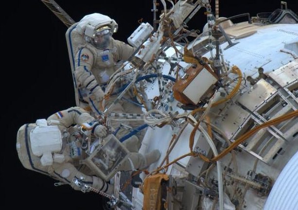
Russian cosmonauts Fyodor Yurchikhin and Alexander Misurkin attempted to install UrtheCast cameras on the space station on Dec. 27, 2013, but the cameras did not send telemetry as expected. At the time, the cause of the problem was not known. The Expedition 38 astronauts were instructed to bring the cameras back inside for more analysis. Credit: Rick Mastracchio (Twitter)
Customers eager to watch live, high-definition images of Earth may have to wait a bit longer. Two Russian spacewalkers were unable to get two UrtheCast cameras to function despite spending eight hours and seven minutes outside yesterday (Dec. 27) — the longest spacewalk in Russian history.
The cause of the problem is not known. Oleg Kotov and Sergey Ryazanskiy followed all the steps as instructed, but controllers did not see telemetry or data flowing from the cameras as expected. The spacewalkers tried unplugging and replugging cables and other steps to fix the problem, but were eventually told to take some pictures of the equipment and then bring the cameras back inside for more analysis.
“So it appears we have seen an unsuccessful attempt at bringing those two cameras to life,”said Rob Navias, NASA’s Mission Control commentator, in live remarks published on CBS.
“The exact cause of the problem is not known at this point. The Russian flight control team will spend some time, obviously, analyzing the data and trying to understand from the analysis of these photographs whether or not the problem lies in the electrical connectors themselves or in the cameras, which of course would be a more significant issue.”
In remarks on Twitter, UrtheCast said it was preparing an official statement to release. ” ‘Tis the nature of space tech,” the British Columbia-based company said in response to a comment talking about the challenges of doing high-tech work in space. The company also made a comment to Reuters saying there was a problem with camera connectivity.
NASA astronaut Mike Hopkins during a spacewalk Dec. 24, 2013 to replace a malfunctioning ammonia pump on the International Space Station. He and fellow Expedition 38 astronaut Rick Mastracchio took two spacewalks to perform the repair job. Credit: NASA
UrtheCast plans to use the two cameras to broadcast live views of the Earth to paying customers (particularly government and private agencies), while also serving as an educational platform for young students. The company is working directly with Russian aerospace giant RSC Energia and has no agreement with NASA for the work, according to this past Universe Today report.
The longest spacewalk in history took place on March 11, 2001 and took eight hours, 56 minutes. NASA astronauts Jim Voss and Susan Helms were doing work on the International Space Station during the record-setting jaunt.
This was the third spacewalk in a week on station. The other two were performed by Rick Mastracchio and Mike Hopkins, who replaced an ammonia pump needed to keep one of the station’s two cooling loops functioning. Experiments are gradually coming back online, NASA said, after the equipment spent two weeks in a forced shutdown.
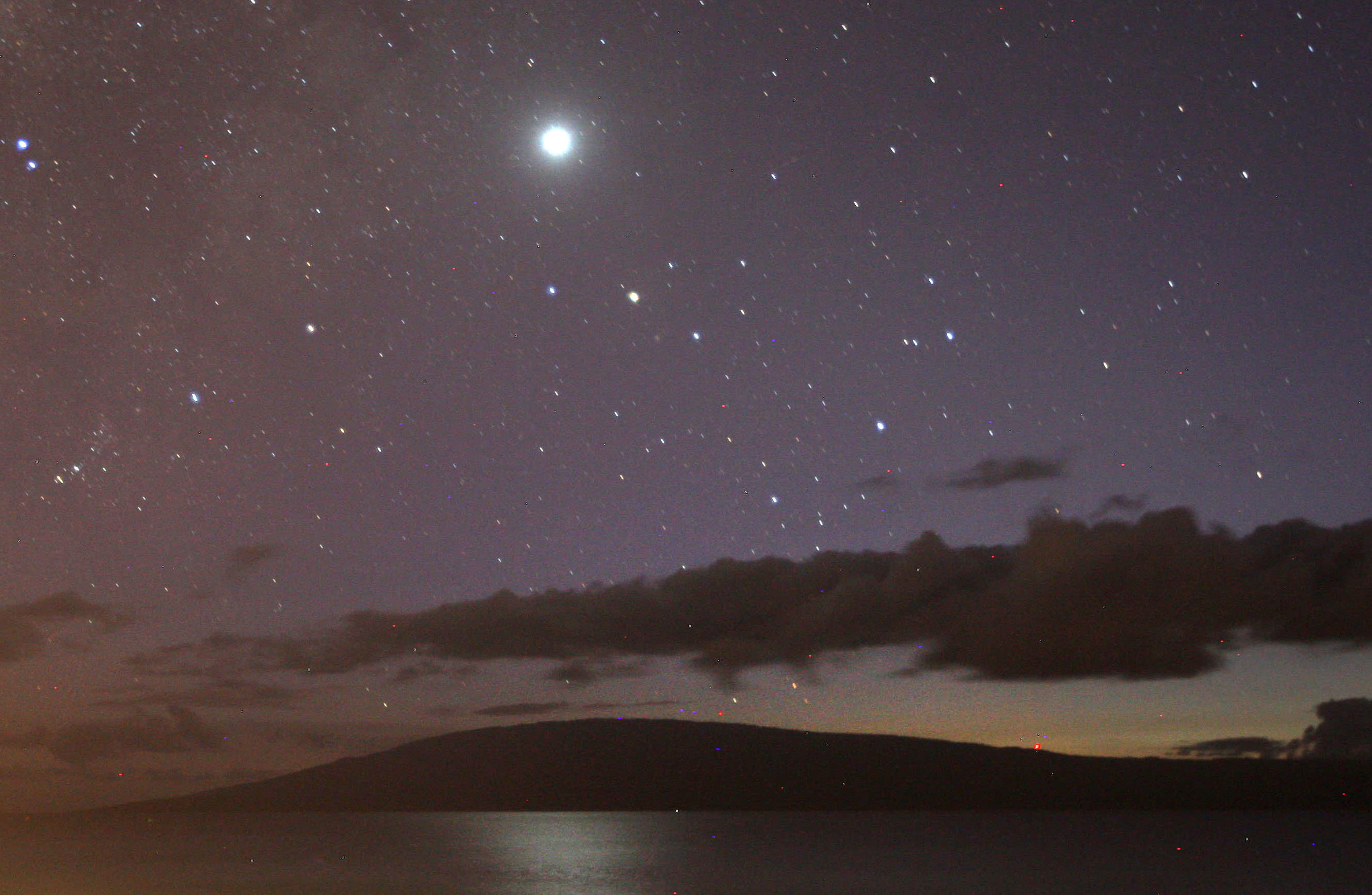
Venus reflected in the Pacific Ocean late this fall seen from the island of Maui, Hawaii. The planet is now quickly dropping toward the sun. Credit: Bob King
I put down down the snow shovel to give my back a rest yesterday evening and couldn’t believe what I saw. Or didn’t see. Where was Venus? I looked to the south above the tree line and the goddess was gone! Sweeping my gaze to the right I found her again much closer to the western horizon point and also much lower.
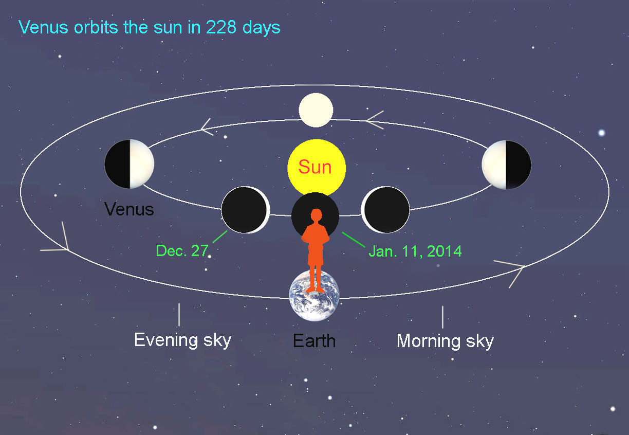
As Venus revolves around the sun interior to Earth’s orbit, we see it pass through phases just like the moon. Tonight it’s still to the east of the sun (left side) and visible in the evening sky. On Jan. 11 it passes through conjunction and then appears on the other side of the sun in the morning sky. Illustration: Bob King
As 2013 gives way to the new year, Venus winds up its evening presentation as it prepares to transition to the morning sky. Catch it while you can. Each passing night sees the planet dropping ever closer to the horizon as its apparent distance from the sun shrinks. On January 11 it will pass through inferior conjunction as it glides between Earth and sun. Come the 12th, Venus nudges into the dawn sky – don’t expect to see it with the naked eye until around midmonth, when it’s far enough from the sun to bust through the twilight glare.
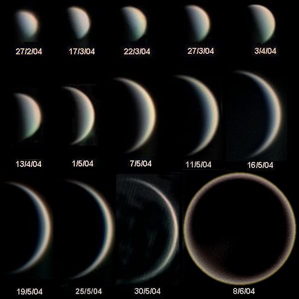
Phases of Venus during 2004 photographed through a telescope. When very close to inferior conjunction (bottom right) the crescent is seen to extend fully around the planet. Credit: Statis Kalyva / Wikipedia
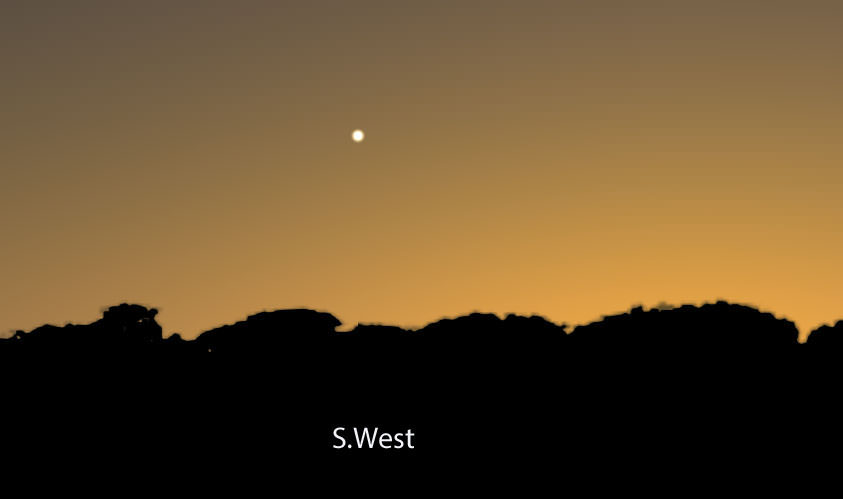
Though the planet is departing, don’t let it disappear without at least a glance through binoculars. As conjunction approaches, Venus gets as close (and as large) as it can get to Earth and displays a most attractive crescent phase. Even 7x binoculars will show its thinning sickle shortly at dusk. Tonight (Dec. 27) Venus measures nearly 1 arc minute in diameter or 1/30 the width of the full moon and shines brightly at magnitude -4.5.
Venus is only about 12 degrees high in the southwestern sky some 20 minutes after sunset this evening Dec. 27. Stellarium
As the planet drops ever lower, the crescent grows both larger and thinner. A few days before conjunction, a telescope will show it extending beyond the usual 180-degree arc as sunlight beaming from behind Venus is scattered by the planet’s thick cloudy atmosphere.
When the air is transparent and seeing steady, amateur astronomers have photographed and observed the crescent wrapping a full 360 degrees around the planet’s disk – a sight quite unlike anything else in the sky.
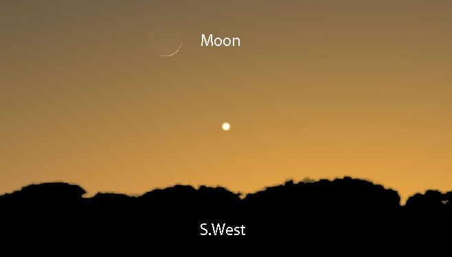
Before Venus departs the evening sky, watch for it to pair up with a very thin crescent moon shortly after sunset on Jan. 2, 2014. Stellarium
In the coming week, watch for Venus starting about 15 minutes after sunset low in the southwestern sky. With each day, the planet becomes slightly less conspicuous as it competes against the twilight glow.
After final farewells late next week, we’ll look forward in the new year to welcoming the goddess in her new guise as morning star.
This image shows Nova Centauri 2013, a bright naked eye nova in the Southern constellation of Centaurus. The nova appears pink because of emissions from ionised hydrogen. Credit and copyright: Rolf Wahl Olsen.
A recent naked-eye visible nova that erupted the first week in December 2013 is still showing its stuff, and this new “hot off the press” image from Rolf Wahl Olsen in New Zealand reveals its unusual color. “I managed to grab a close-up of Nova Centauri 2013 with my new 12.5″ f/4 scope,” Rolf said via email to Universe Today. “Curiously, I have only so far seen wide field images of this nova, and none that actually show it’s very unusual strong pink colour.”
Nova Centauri 2013 (in the Southern constellation of Centaurus) was discovered by John Seach from Australia on December 2, 2013, and it was visible at about magnitude 5.5. It subsequently brightened to reach a peak at magnitude 3.3.
Rolf’s image was taken today (it’s already Dec. 28, 2013 in New Zealand!) when the nova had faded to around magnitude 4.5. You can see a larger version here on Flickr or click the image above for a larger version on Rolf’s website.
Why is it pink?
“The nova appears pink because we are really viewing the light from an expanding shell of ionized hydrogen which emits strongly in both the red and blue part of the optical spectrum,” Rolf explained. “These emissions give the nova its strong pinkish colour, similar to emission nebulae which are also predominantly pink/magenta in hue.”
A nova is the result of a thermonuclear explosion on the surface of a white dwarf star in a tight binary system. The white dwarf accretes matter from its nearby companion and eventually the pressure from nuclear fusion blows off the accreted layers from the surface of the white dwarf. Contrary to a supernova where the star itself is blown apart and ceases to exist, a nova does not result in the destruction of the host star. The white dwarf may continue to accrete matter from its companion and the process may repeat itself sometime in the future.
Image details:
Date: 28th Dec 2013
Exposure: LRGB: 17:7:6:6 mins, total 36 mins @ -25C
Telescope: 12.5″ f/4 Serrurier Truss Newtonian
Camera: QSI 683wsg with Lodestar guider
Filters: Astrodon LRGB E-Series Gen 2
Taken from Auckland, New Zealand
Dr. Ian O’Neill is one of the coolest scientists we know, so we sat him down at the YouTube spaces and asked him a real zinger – when will we humans become an interstellar race, like the ones we’re used to seeing on Star Trek? Here’s what he had to say to us! Continue reading “When Will We Become Interstellar?”
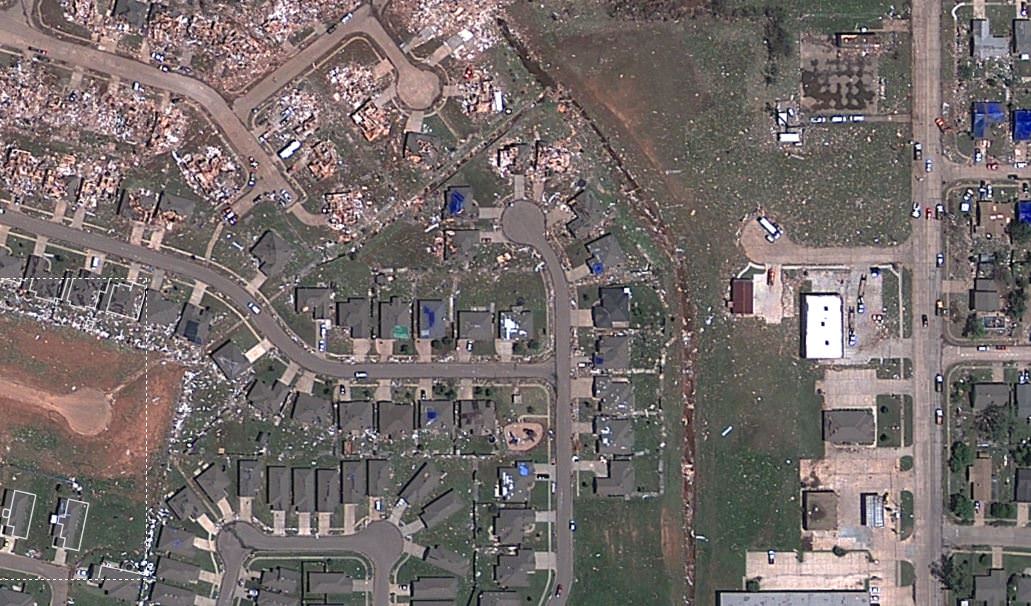
Sceenshot of a satellite view from Google/Digital Globe of the destruction in Moore, Oklahoma after the May 20, 2013 tornado. Click image to have access to an interactive, zoomable version via NPR.
For all you Earth observation geeks out there, we have some good news — two Russian astronauts are going to install a camera on Friday (Dec. 27) that will beam live images of Earth back to your browser.
The UrtheCast camera is the headline task for Expedition 38 astronauts Oleg Kotov and Sergey Ryazanskiy to perform, on top of installing a foot restraint and doing some equipment swapouts. This spacewalk, by the way, is not related in any way to the two successful contingency ones earlier this week to replace a faulty pump on station.
The spacewalk is supposed to start at 8 a.m. EST (1 p.m. UTC) and will be carried live on NASA Television, which you can view in the media player above or at this alternate link. The spacewalk is scheduled for seven hours, but could be longer or shorter as events arise.
“Imagine you have a nearly live Google Earth, but it isn’t four-year-old data – you have data that is being refreshed all the time, with videos coming down over interesting areas where interesting events are going on, showing you what is changing, what is going on,” said George Tyc, the chief technology officer at UrtheCast, in an interview with Universe Today earlier this year.
“What we really hope to pull off is to change the paradigm, get the everyday person interacting and seeing the data coming down from space to see the Earth and how it is evolving over time in a way that isn’t available right now.”
NASA astronaut Mike Hopkins during his first spacewalk on Dec. 21, 2013 during Expedition 38. He tweeted the next day: “Wow . . . can’t believe that is me yesterday. Wish I could find the words to describe the experience, truly amazing.” Credit: NASA
It’s been a busy week for spacewalkers on station as Rick Mastracchio and Mike Hopkins successfully replaced a pump that shut down two weeks ago and crippled one of the station’s two cooling loops for regulating the temperature of systems on station. With that work completed Tuesday (Dec. 24), a NASA update today (Dec. 26) said systems are slowly coming back online.
“Early on Christmas Day, the heat exchangers for the Destiny laboratory, the Harmony and Tranquility nodes and the Japanese Kibo laboratory were reintegrated to enable experiments racks and other systems affected by the partial Cooling Loop A shutdown Dec. 11 to come back on line,” NASA stated.
“The Columbus laboratory heat exchanger will remain down until the European Space Agency, at its own request, conducts that module’s integration next week when personnel return from the holiday.”
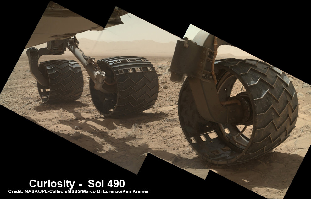
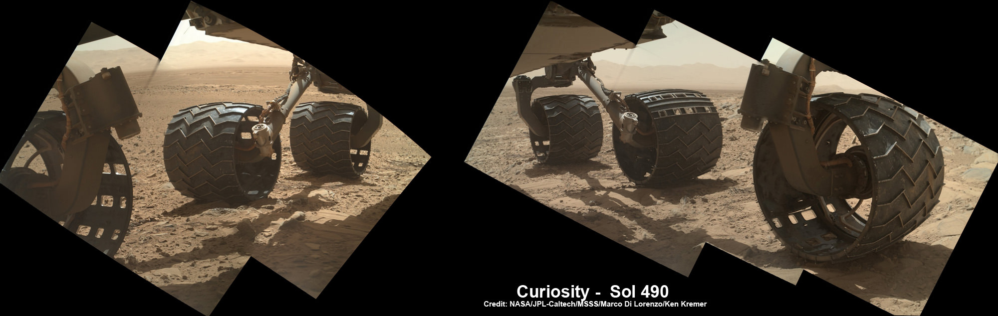
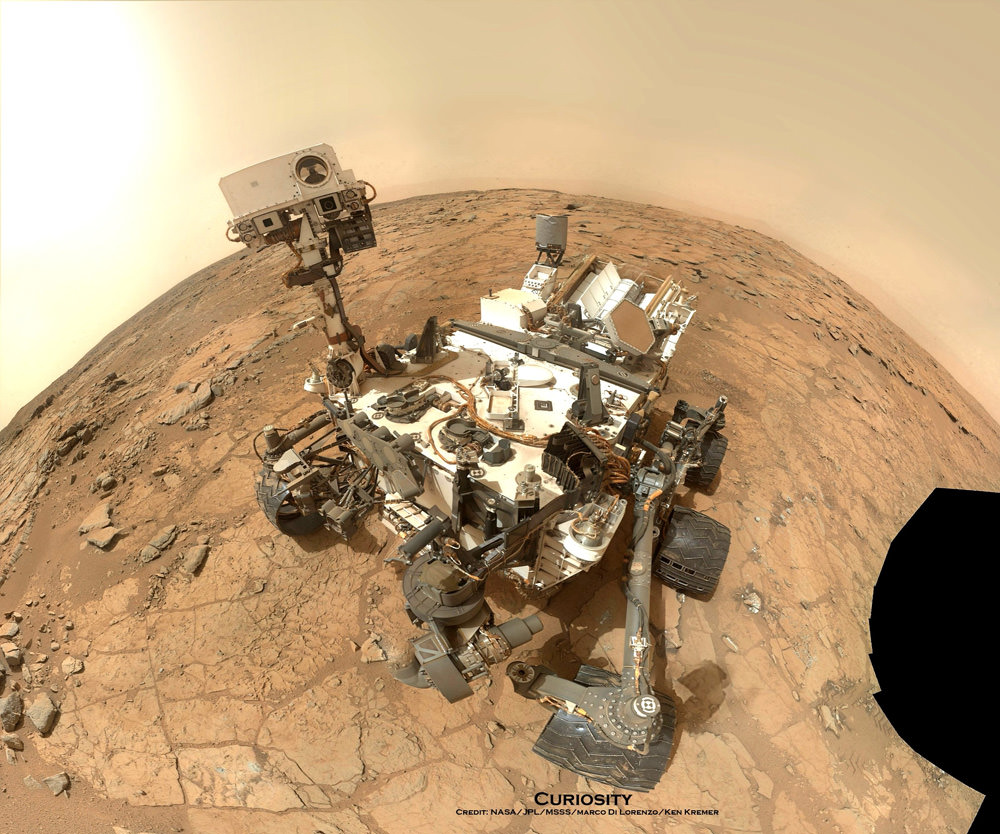
Photomosaic shows new holes and tears in several of rover Curiosity’s six wheels caused by recent driving over sharp edged Martian rocks on the months long trek to Mount Sharp. Raw images taken by the MAHLI camera on Curiosity’s arm on Dec. 22, 2013 (Sol 490) were assembled to show some recent damage to several of its six wheels – most noticeably the two here in middle and front. Credit: NASA / JPL / MSSS / Marco Di Lorenzo / Ken Kremer- kenkremer.com
See below complete 6 wheel mosaic and further wheel mosaics for comparison
Photomosaic shows new holes and tears in several of rover Curiosity’s six wheels caused by recent driving over sharp edged Martian rocks on the months long trek to Mount Sharp. Raw images taken by the MAHLI camera on Curiosity’s arm on Dec. 22, 2013 (Sol 490) were assembled to show some recent damage to several of its six wheels – most noticeably the two here in middle and front. Credit: NASA / JPL / MSSS / Marco Di Lorenzo / Ken Kremer- kenkremer.com See below complete 6 wheel mosaic and further wheel mosaics for comparison [/caption]
Several of the NASA rovers six big aluminum wheels have suffered some significant sized rips, tears and holes up to several centimeters wide – in addition to numerous dents – as she has picked up the driving pace across the rugged, rock filled Martian terrain this past fall and put over 4.5 kilometers (3 mi.) on the odometer to date.
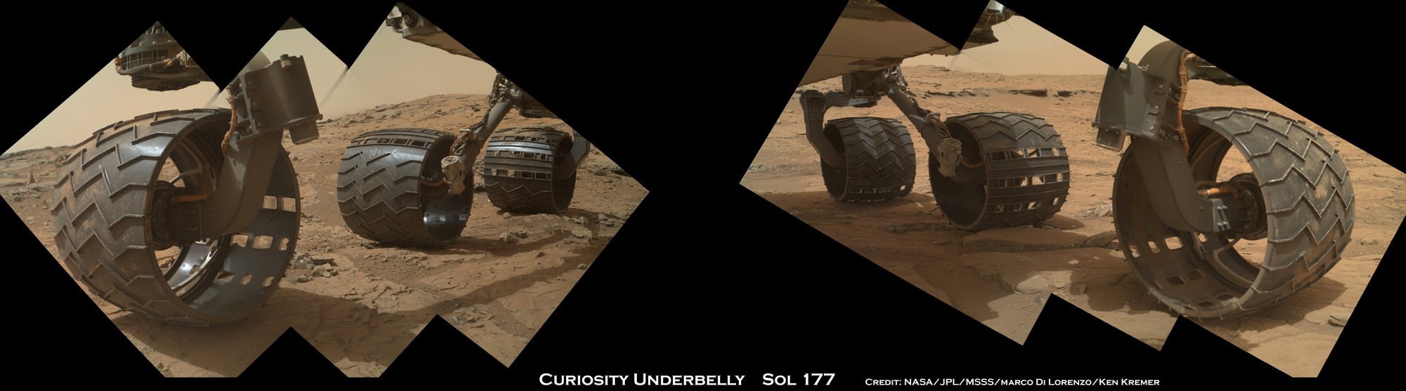
It’s rather easy to spot the wheel damage to the 1 ton behemoth by examining the mosaic imagery we have created – See above and below – from newly transmitted raw imagery and comparing that to older imagery taken at earlier points in the mission. Check our Sol 177 wheels mosaic below.
The latest imagery from Mars captured just prior to Christmas is delivering an undesired holiday present of sorts to team members that might well cause the scientists and engineers to alter Curiosity’s extraterrestrial road trip to traverse smoother terrain and thereby minimize future harm.
So the wheel damage is certainly manageable at this point but will require attention.
The team of Marco Di Lorenzo and Ken Kremer have assembled the new Mastcam and MAHLI raw images of the wheels captured on Sol 490 (Dec. 22) into fresh color mosaics – shown herein.
Photomosaic shows new holes and tears in several of rover Curiosity’s six wheels caused by recent driving over sharp edged Martian rocks on the months long trek to Mount Sharp. Raw images taken by the MAHLI camera on Curiosity’s arm on Dec. 22, 2013 (Sol 490) were assembled to show some recent damage to several of its six wheels – most noticeably the two at right in middle and front. Credit: NASA / JPL / MSSS / Marco Di Lorenzo / Ken Kremer- kenkremer.com
See below more wheel mosaics for comparisonPhotomosaic from Sol 177 (Feb. 3, 2013) shows rover Curiosity’s six wheels relatively intact with far fewer holes and dents compared to Sol 490 mosaic taken on Dec 22. 2013. Rover is working in Yellowknife Bay here and had not yet begun long trek to Mount Sharp. Sol 177 raw images assembled to mosaic were taken by the MAHLI camera on Curiosity’s arm. Credit: NASA/JPL/MSSS/Marco Di Lorenzo/Ken Kremer- kenkremer.com
Indeed the rovers handlers have already directed the SUV sized Curiosity to snap close up images of the 20 inch diameter wheels with the high resolution color cameras located on the Mast as well as the Mars Hand Lens Imager (MAHLI) camera at the end of the rover’s maneuverable robotic arm.
“We want to take a full inventory of the condition of the wheels,” said Jim Erickson of NASA’s Jet Propulsion Laboratory, project manager for the NASA Mars Science Laboratory Project, in a NASA statement.
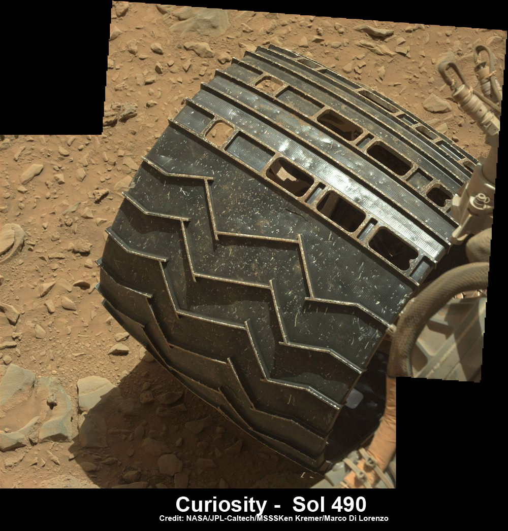
Up close view of hole in one of rover Curiosity’s six wheels caused by recent driving over rough Martian rocks. Mosaic assembled from Mastcam raw images taken on Dec. 22, 2013 (Sol 490) Credit: NASA/JPL/MSSS/Ken Kremer -kenkremer.com/Marco Di Lorenzo
The rover team certainly expected some wear and tear to accumulate along the rock strewn path to the base of Mount Sharp – which reaches 5.5 km (3.4 mi) into the Martian sky.
But the volume of sharp edged rocks encountered in the momentous trek across the floor of Curiosity’s Gale Crater landing site apparently has picked up- as evidenced by the new pictures – and consequently caused more damage than the engineers anticipated.
“Dents and holes were anticipated, but the amount of wear appears to have accelerated in the past month or so,” Erickson noted.
“It appears to be correlated with driving over rougher terrain. The wheels can sustain significant damage without impairing the rover’s ability to drive. However, we would like to understand the impact that this terrain type has on the wheels, to help with planning future drives.”
The team is now inspecting the new imagery acquired of the wheels and will decide if a course alteration to Mount Sharp is in order.
The left front wheel may have suffered the most harm.
Up close view shows a tear in one of rover Curiosity’s six wheels caused by recent driving over rough Martian rocks. Mosaic assembled from Mastcam raw images taken on Dec. 22, 2013 (Sol 490) Credit: NASA/JPL/MSSS/Ken Kremer -kenkremer.com/Marco Di Lorenzo
“Routes to future destinations for the mission may be charted to lessen the amount of travel over such rough terrain, compared to smoother ground nearby,” says NASA.
Following a new, post Christmas drive today, Dec. 26, 2013 (Sol 494) Curiosity’s odometer stands at 4.6 kilometers.
Curiosity has already accomplished her primary goal of discovering a habitable zone on Mars that could support Martian microbes if they ever existed.
NASA’s rover Curiosity uncovered evidence that an ancient Martian lake had the right chemical ingredients that could have sustained microbial life forms for long periods of time – and that these habitable conditions persisted on the Red Planet until a more recent epoch than previously thought.
Right now the researchers are guiding Curiosity along a 10 km (6 mi) path to the lower reaches of Mount Sharp – which they hope to reach sometime in mid 2014.
NASA’s Mars rover Curiosity took this self-portrait, composed of more than 50 images using its robotic arm-mounted MAHLI camera, on Feb. 3. The image shows Curiosity at the John Klein drill site. A drill hole is visible at bottom left. Credit: NASA / JPL / MSSS / Marco Di Lorenzo / Ken Kremer- kenkremer.com
Stay tuned here for Ken’s continuing Curiosity, Chang’e-3, LADEE, MAVEN, Mars rover and MOM news.
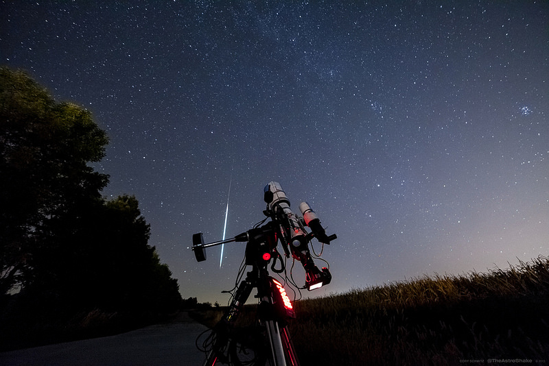
An early Draconid meteor caught by astrophotographer Cory Schmitz. (Used with permission?)
It’s here!
As 2013 draws to a close, we once again cast our thoughts to all things astronomical for the coming year. For the past five years, I’ve been constructing this list of all things astronomical for the coming year, lovingly distilling the events transpiring worldwide down to a 101 “best events of the year”. This is the first year this list has been featured on Universe Today, so we’ll lay out our ground rules and reasoning a bit as to selection criteria.
Events selected run the gamut from conjunctions and eclipses that are visible worldwide or over a good swath of the planet, to asteroid occultations of stars that are only visible along a thin path along the surface of the Earth. Geocentric conjunction times for occultations are quoted. Generally, only conjunctions involving bright stars, planets & the Moon are noted. The intent of this list is to bridge the gap between the often meager “10 Best Astronomy Events of 2014” listicles that make their rounds this time of year and the more tedious laundry lists of Moon phases and wide conjunctions.
As always, we look at the coming year with an eye out for the astronomically curious and the bizarre. Times are quoted in Universal Time (UT) using a 24-hour clock, which is identical to Greenwich Mean Time (GMT) and Zulu for those in the military.
Some caveats as to how selections were made:
-To make the cut, asteroid occultations must have a rank of 99 or greater, and occult a star brighter than +8th magnitude.
– We only selected major annual meteor showers with a Zenithal Hourly Rate (ZHR) projected to be 20 or greater.
– Only lunar occultations of planets and bright stars are listed.
– Solstice seasons where the International Space Station reaches full illumination are approximate; the ISS gets boosted periodically, and therefore it’s impossible to project its precise orbit months in advance.
– Comets come and go. The comets included on this list are some of the “best bets” that are forcasted to reach binocular visibility for 2014. A big bright one could come up and steal the show at any time!
This list was meant to “whet the appetite” for what’s coming to skies worldwide in 2014 with a succinct rapid fire listing by month. Where an online resource exists that expands on the event, we linked to ‘em. A full resource list, both paper and cyber, is given at the end of the post. Print these events, post it on your refrigerator and/or observatory wall, and expect us to feature many these fine events on Universe Today in the coming year!
Some notes on 2014:
2014 sees Mars reach opposition in early April, which is sure to be a highlight as we head towards an exceptionally close opposition in 2018.
The month of February is also missing a New Moon, which last occurred in 1995 and won’t happen again until 2033. February is the only calendar month which can be missing the same moon phase twice!
We’re also coming off a profoundly weak solar maximum in 2014, though as always, the Sun may have some surprises in store for solar observers and aurora watchers worldwide.
The motion of the Moon in 2014 is headed towards a “shallow” year in 2015 relative to the ecliptic; it will then begin to slowly open back up and ride high around 2025.
2014 also contains the minimum number of eclipses that can occur in one year, 2 solar and 2 lunar. And while there are no total solar eclipses in 2014, there are two fine total lunar eclipses, both visible from North America.
And here’s the month by month rundown:
The view looking west from the US east coast at 6 PM on January 1st from latitude 30 degrees north. (Created in Stellarium).
03- Quadrantid meteors peak with a ZHR=120 at ~05:00 UT, best seen from the Atlantic region. Favorable in 2014, with the Moon a 2 day old waxing crescent.
04- Earth reaches perihelion at 12:00 UT, 147.1 million kilometres from the Sun.
04- Mars passes 1.3’ from the +11.5th magnitude galaxy NGC 4684.
10- A Possible meteor shower due to dust from the Comet (formerly known as) ISON over the next few days?
11- Venus reaches inferior conjunction between the Sun and the Earth, shining at -4th magnitude. It may be just possible to spot it five degrees north of the solar limb from high northern latitudes.
13- Moon reaches its farthest northern declination for 2014 a 19.4 degrees.
16- The most distant Full Moon, and visually smallest Full Moon of 2014 occurs, with the Moon reaching Full within two hours of apogee. MiniMoon!
25- The Moon occults Saturn for the South Pacific at ~13:58 UT.
27- The Moon reaches its farthest southern declination for 2014, at -19.3 degrees.
30- ABlack Moon occurs, as reckoned as the second New Moon in a month with two.
31- Mercury reaches a favorable elongation, shining at magnitude -0.9, 18.4 degrees east of the Sun.
Venus occultation footprint for February 26th. (Created using Occult v4.1.0).
February
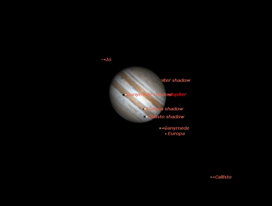
06- Twoshadows transit the cloud tops of Jupiter from 10:20 UT-12:44 UT, favoring western North America.
21- The Moon occults Saturn for the Indian Ocean at ~22:18 UT.
26- The 14% waning crescent Moon occults Venus for central Africa at ~5:23 UT.
March
07- Asteroid 9 Metis occults a +7.9 magnitude star for Europe ~3:14 UT.
10- The 70% illuminated waxing gibbous Moon occults the +3.6 magnitude star Lambda Geminorum for North America in the evening sky.
14- Mercury reaches greatest morning elongation at 27.5 degrees west of the Sun shining at magnitude +0.1. Mercury’s best morning apparition in 2014 for southern hemisphere observers.
16- A double shadow transit of Jupiter’s moons occurs from 22:20 to 00:35 UT, visible from Atlantic Canada after sunset.
20- The Northward Equinox occurs at 16:57 UT.
20- GEO satellite eclipse season occurs, as geostationary satellites enter Earth’s shadow near the equinox.
20- Regulus is occulted by asteroid 163 Erigone for the NE United States and Canada at ~6:07 UT, The brightest star occulted by an asteroid in 2014.
21- The Moon occults Saturn for the South Atlantic at ~3:18 UT.
24- A double shadow transit of Jupiter’s moons occurs from 2:08 to 2:28 UT, favoring eastern North America.
24- Asteroid172 Baucisoccults a +6.7 magnitude star for South America at ~9:27 UT.
22- Venus reaches greatest morning elongation, at 47 degrees west of the Sun.
28- Asteroid 51 Nemausa occults a +7.7 magnitude star for Africa at 20:02 UT.
30- A Black Moon occurs, as reckoned as the second New Moon in one month.
The viewing prospects for the April 15th Total Lunar Eclipse. (Credit: NASA/GSFC/Espenak/Meeus).
April
08- Mars reaches opposition for 2014, shining at magnitude -1.5.
12- A close conjunction of Venus and Neptune occurs, with the planets just 0.7 degrees apart at 2:00 UT.
15- A Total Lunar Eclipse occurs, visible from the Americas and centered on 7:47 UT.
17- The Moon occults Saturn for South America at ~7:19 UT.
29- An Annular Solar Eclipse visible from Australia and the southern Indian Ocean occurs, centered on 6:05 UT. This is a unique, non-central antumbral eclipse!
May
03- Asteroid 105 Artemis occults a +7.7 magnitude star for NW Brazil and Peru at ~9:17 UT.
04- Asteroid 34 Circe occults a +7.4 magnitude star for Peru and Ecuador at ~10:12 UT.
06- The closest lunar apogee of 2014 occurs at 404,318 km distant at 10:23 UT.
07- Eta Aquariid meteors peak, with a ZHR=55 at 4:00 UT. Best observed from the Atlantic Region. Favorable in 2014, with the 7-day old Moon at waxing gibbous.
07- Asteroid 206 Hersilia occults a +7.5 magnitude star for Australia and Indonesia at ~17:49 UT.
10- Saturn reaches opposition for 2014, shining at magnitude +0.1. Saturn’s rings are tipped open a maximum of 23 degrees to our line of sight on February 11th, and widening overall in 2014.
13- A double shadow transit of Jupiter’s moons occurs from 9:20-9:32 UT favoring NW North America.
14- The Moon occults Saturn for Australia and New Zealand at ~12:18 UT.
24- Ameteor shower outburst may be in the offing, courtesy of Comet 209P LINEAR. Will the “Camelopardalids” perform?
24- Asteroid 33 Polyhymnia occults a +5.5 magnitude star for South America at ~8:30 UT.
25- Mercury reaches maximum dusk elongation, 22.7 degrees east of the Sun. Mercury’s best evening apparition for 2014 for northern hemisphere viewers.
The triple shadow transit of June 3rd, as seen at 19:00 UT. (Created by the author using Starry Night).
June
3- A triple Jovian shadow transit occurs from 18:05-19:44 UT, favoring eastern Europe and Africa. This is the only triple shadow transit for 2014.
10- The Moon occults Saturn for the southern Indian Ocean at ~18:48 UT.
21- The Northward Solstice occurs at ~10:51 UT.
22- The International Space Station enters a period of full illumination near the June solstice, favoring multiple views for northern hemisphere viewers.
26- The Moon occults Mercury just 20 hours prior to New… a tough catch, but may visible from the SE US and Venezuela just before sunrise.
27- The June Boötid meteors peak, with a ZHR variable from 0-100 at ~15:00 UT, favoring the Central Pacific. Optimal in 2014, as the Moon is at New phase.
July
04- Earth reaches aphelion at 2:00 UT, at 152,098,232 kilometres from the Sun.
04- Pluto reaches opposition at 3:00 UT.
05– 1 Ceres passes just 10’ from 4 Vesta in the constellation Virgo.
06– The Moon occults Mars for South America at ~01:21 UT
08– The Moon occults Saturn for Argentina & Chile at ~2:25 UT.
12- Mercury reaches its maximum elongation of 20.9 degrees west of the Sun, shining at magnitude +0.4 in the dawn.
12– The first Full Proxigean “Super” Moon (1 of 3) for 2014 occurs at 11:27 UT. The Moon reaches Full 21 hours prior to perigee.
30– The Southern Delta Aquarids peak, with a ZHR=20. Time variable, favorable in 2014 with the waxing crescent Moon 4 days past New.
20– Asteroid 451 Patientia occults a +7.1 magnitude star for South Africa at ~17:15 UT.
28- The farthest lunar apogee of 2014 occurs, with the Moon 406,568 kilometres distant at 3:28 UT.
30– Asteroid 103 Hera occults a +6.1 magnitude star for west Africa and central South America at ~1:11 UT.
A tri-conjunction of the Moon, Venus & Jupiter on the morning of August 23rd- A “Skewed Smiley face” conjunction!” Credit: Stellarium).
August
02– A close conjunction of Mercury and Jupiter occurs, with the planets just 0.9 degrees apart at 19:00 UT. Visible in SOHO’s LASCO C3 camera.
10– The closest lunar perigee of 2014 occurs, with the Moon 356,896 kilometres distant at 17:44 UT.
10- The Closest Full Moon of the year & “Super” Moon (2 of 3) for 2014 occurs, with Full Moon occurring just 27 minutes after perigee.
13– The Perseid meteors peak, with a ZHR=100 at ~04:00 UT favoring The Atlantic region. Unfavorable in 2014, with the 17 day old Moon at waning gibbous.
18- A conjunction of Venus and Jupiter occurs 5:00 UT, the closest conjunction of two naked eye planets in 2014, with the two just 15’ apart.
29- Neptune reaches opposition at 14:00 UT, shining at +7.8 magnitude.
31– The Moon occults Saturn for Africa and the eastern US (in the daytime) at ~18:59.
September
05- Venus passes 0.7 degrees from the bright star Regulus.
09– The final Full “Super” Moon (3 of 3) for 2014 occurs at 1:39 UT, just 22 hours after perigee.
15– Comet C/2013 V5 Oukaimeden may reach +5.5th magnitude for southern hemisphere observers.
20– Mercury passes 0.5 degrees south of the bright star Spica at 21:00 UT.
21- Mercury reaches its greatest elongation of 26.4 degrees east of the Sun shining at magnitude +0.0 in the dawn sky. Mercury’s best sunset apparition for 2014 for southern hemisphere observers.
23- The Southward Equinox occurs at 2:29 UT.
23- GEO satellite eclipse season occurs, as geostationary satellites enter Earth’s shadow near the equinox.
28– The Moon occults Saturn for the northern Pacific at ~4:25 UT. The Moon also occults 1 Ceres and 4 Vesta on the same day!
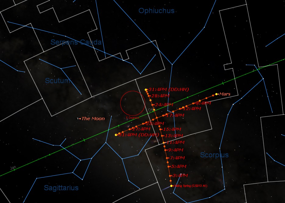
The path of Comet C/2013 A1 Siding Springs versus the planet Mars through October, 2014. (Created by the author using Starry Night).
October
04- 1 Ceres passes just 30’ north of Saturn.
06- PossibleDraconid meteor shower, highly variable in terms of rates and timing, but unfavorable in 2014, with the Moon just two days from Full.
08- A Total Lunar Eclipse visible from the Pacific Rim region occurs, centered on 10:56 UT. The planet Uranus will also lie less than a degree away from the eclipsed Moon!
14- Comet C/2012 K1 PanSTARRS may reach +5th magnitude for southern hemisphere viewers.
13– The Moon reaches it shallowest northern declination for 2014 at +18.5 degrees.
19- Comet C/2013 A1 Siding Spring passes just 7’ from the planet Mars. Globular cluster NGC 6401 also lies nearby.
22– The Orionid meteor shower peaks at ~05:00 UT, with a predicted ZHR=25 favoring the Americas. Optimal in 2014, with the Moon at waning crescent.
22– The Moon occults Mercury for Australia just 24 hours prior to New as seen from Australia.
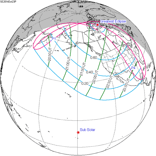
23- A Partial Solar Eclipse visible from western North America occurs centered on 21:46 UT.
25- The Moon occults Saturn for the northern Atlantic at ~15:43 UT.
25- The Moon reaches its shallowest southern point for 2014, at a declination of -18.6 degrees.
The partial solar eclipse of October 23rd, 2014. (Credit: NASA/GSFC/Fred Espenak).
November
01- Mercury reaches its greatest elongation 18.7 degrees west of the Sun, shining at magnitude -0.5. The best morning apparition of Mercury for 2014 as seen from the northern hemisphere.
18– Leonid meteors peak at 05:00 UT with a ZHR=20 favoring the Atlantic region. Optimal in 2014, with the 25 day old Moon at waning crescent phase.
20- Asteroid 3 Juno occults a +7.4 magnitude star for the US NE and eastern Canada.
27- The farthest lunar perigee of 2014 occurs with the Moon 369,824 km distant at 23:12 UT.
December
09- A double shadow transit of Jupiter’s moons occurs from 4:18 to 4:27 UT favoring eastern North America.
12- A double shadow transit of Jupiter’s moons occurs from 16:19 to 16:44 UT favoring NW North America.
13- The Geminid meteors peak with a ZHR=120 at ~01:00 UT, favoring the Middle East & Eastern Europe. Unfavorable in 2014, with the 20 day old Moon at waning gibbous.
18- Asteroid 702 Alauda occults a +6.2 magnitude star at 14:12 UT for eastern Australia.
21- The Southward Solstice occurs at 23:03 UT.
21- The International Space Station enters period of full illumination around the solstice, with multiple nightly views favoring the southern hemisphere.
21- A double shadow transit of Jupiter’s moons occurs from 14:17 to 15:55 UT, favoring the Far East and Australia.
Don’t see your favorite or most anticipated event of 2014 on the list? Drop us a line and let us know!
And finally, thanks to all of those too numerous to name who provided discussions/diatribes/input via Twitter/G+/message boards/etc to make this listing possible… let another exciting year of astronomy begin!
If you’ve got a space-related blog, you should really join the carnival. Just email an entry to [email protected], and the next host will link to it. It will help get awareness out there about your writing, help you meet others in the space community – and community is what blogging is all about. And if you really want to help out, sign up to be a host. Send an email to the above address.
NASA astronaut Mike Hopkins holds a spare ammonia pump module during a spacewalk Dec. 24, 2013. Hopkins and fellow Expedition 38 Rick Mastracchio (top) performed two spacewalks to replace a pump blamed for crippling one of the International Space Station's two cooling loops Dec. 11. Credit: NASA TV (screenshot)
Toxic snowflakes in space were just one obstacle astronauts faced down today (Dec. 24) as they successfully replaced an ammonia pump that will, if all goes to plan, put the space station back in full service in a few hours.
“They’re just completely surrounding us now,” radioed NASA astronaut Rick Mastracchio of the ammonia flakes as the astronauts clipped four fluid lines into place on to the spare pump. NASA said the ammonia was just residual fluid and not indicative of a leak. “Some little ones, some big ones,” he added.
Within a few minutes, however, the ammonia dissipated. Some flakes did strike the spacesuits of Mastracchio and fellow NASA spacewalker Mike Hopkins, causing NASA to do a modified decontamination procedure where the astronauts stayed in a vacuum for a few extra minutes inside the airlock. (The sun’s heat bakes off ammonia over time, and the crew was outside long enough for most ammonia to dissipate, NASA said.)
The spacewalk completed with no further drama at 7 hours and 30 minutes, earning high praise for the participating astronauts from Mission Control in Houston.
“It’s the best Christmas ever,” radioed CapCom and NASA astronaut Doug Wheelock from the ground as the spacewalkers entered the International Space Station’s Quest airlock at the end of the repair job. “We got it,” Mastracchio responded.
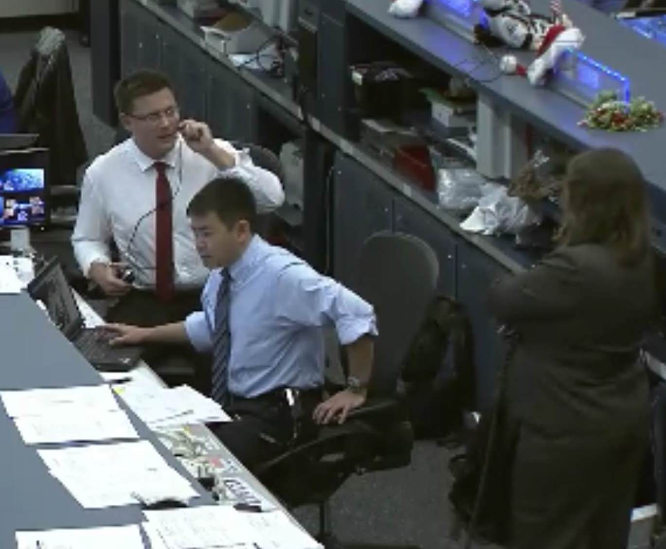
NASA astronaut Doug Wheelock (left) and Japanese astronaut Aki Hoshide served as CapComs during two tricky ammonia pump replacements in December 2013. Wheelock assisted Expedition 38 spacewalking astronauts Mike Hopkins and Rick Mastracchio, while Hoshide helped Japanese astronaut Koichi Wakata with robotic maneuvers. Credit: NASA TV (screenshot)
Preliminary tests show the spare pump is working perfectly. The pump is a welcome present for the six-person Expedition 38 crew, which saw a reduction in science and backup systems for two weeks after a valve in the last pump failed, causing one of the station’s two cooling loops to shut down automatically. The loops are needed to regulate the temperatures of electronics and systems on station.
The Expedition 38 crew was so quick with the repair that they finished the job in two spacewalks instead of the planned three. The astronauts fell behind the timeline today as they struggled with some of the fluid connections to the new pump, but the final steps — putting the electrical connections in place — took just minutes. The pump was brought from another location on station today, and installed into its permanent spot to help ammonia flow through the cooling system.
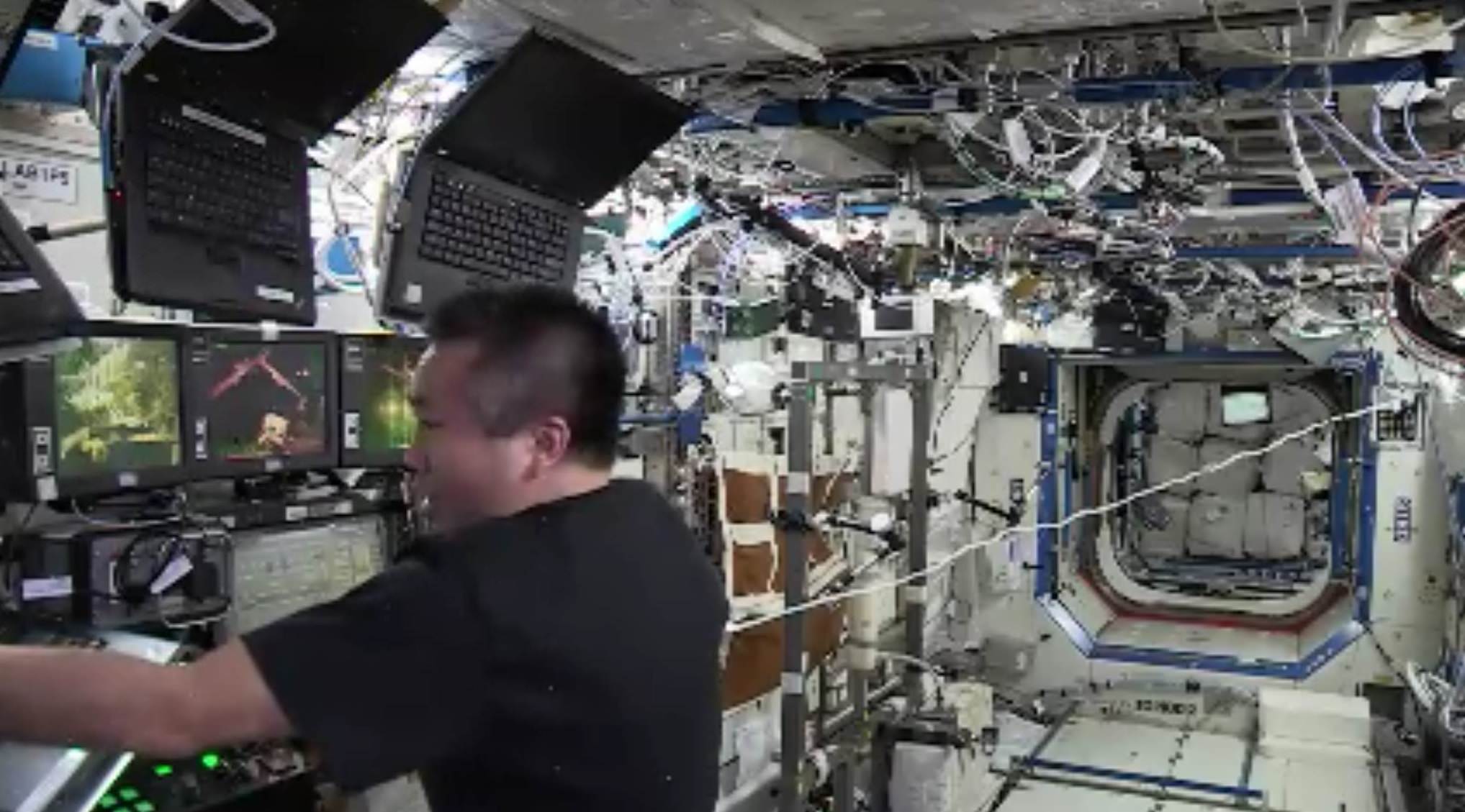
Anywhere between hundreds and thousands of people at NASA and international partners scrambled to put spacewalks together to fix the cooling problem after it happened. Wheelock, himself a veteran of a tricky ammonia pump repair in 2010, communicated with the spacewalkers. Japanese astronaut Aki Hoshide filled the other CapCom slot, helping Japanese astronaut Koichi Wakata who handled robotics in orbit.
Japanese astronaut Koichi Wakata controlled Canadarm2 during two spacewalks to replace a faulty ammonia pump in December 2013. Credit: NASA TV (screenshot)
Mastracchio marked his eighth spacewalk with today’s repair while Hopkins, who rode Canadarm2 for the first time in a last-minute decision, was on his second. As with a spacewalk on Saturday (Dec. 21), the astronauts reported no helmet water leaks — comforting words for agency officials who put in new procedures and parts after an incident in July. (Mastracchio experienced a water problem during repressurization Saturday that was unrelated to the first incident, and wore a backup suit today to let the primary one dry out.)
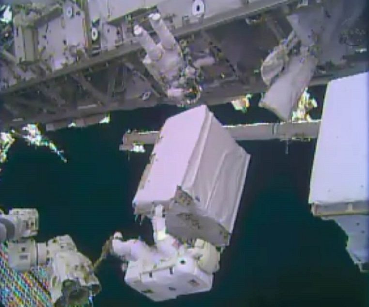
Should the ammonia pump work as planned, this clears the way for the Russians to do a spacewalk Dec. 27 to install the Urthecast high-resolution camera that will beam live views of Earth, among other tasks. Expedition 38 has the day off tomorrow (Dec. 25), NASA TV added.
The only other Christmas Eve spacewalk in NASA history took place Dec. 24, 1999 during Hubble Space Telescope servicing mission STS-103. Another Christmas Eve milestone for NASA took place 45 years ago today, when the Apollo 8 crew made a now-famous broadcast while orbiting above the moon.