Opportunity Scaling Solander Mountain Searching for Science and Sun

Opportunity starts scaling Solander Point See the tilted terrain and rover tracks in this look-back mosaic view from Solander Point peering across the vast expanse of huge Endeavour Crater. Moasic assembled from navcam raw images taken on Sol 3431 (Sept.18, 2013). Credit: NASA/JPL/Cornell/Marco Di Lorenzo/Ken Kremer - kenkremer.com

Opportunity starts scaling Solander Point – her 1st mountain climbing goal
See the tilted terrain and rover tracks in this look-back mosaic view from Solander Point peering across the vast expanse of huge Endeavour Crater. Opportunity will ascend the mountain looking for clues indicative of a Martian habitable environment. This navcam camera mosaic was assembled from raw images taken on Sol 3431 (Sept.18, 2013). Credit: NASA/JPL/Cornell/Marco Di Lorenzo/Ken Kremer (kenkremer.com). See the complete panoramic view below[/caption]

NASA’s intrepid Opportunity rover has begun an exciting new phase in her epic journey – the ascent of Solander Point, the first mountain she will ever climb, after roving the Red Planet for nearly a decade. See the rovers tilted look-back view in our Sol 3431 mosaic above.

Furthermore, ground breaking discoveries providing new clues in search of the chemical ingredients required to sustain life are sure to follow as the rover investigates intriguing stratographic deposits distributed amongst Solander’s hills layers.

Why ? Because NASA’s powerful Mars Reconnaissance Orbiter (MRO) circling overhead has also recently succeeded in collecting “really interesting” new high resolution survey scans of Solander Point! Read my prior pre-survey account – here.

So says Ray Arvidson, the mission’s deputy principal scientific investigator, in an exclusive Opportunity news update to Universe Today. The new MRO data are crucial for targeting the rover’s driving in coming months.

After gaining approval from NASA, engineers successfully aimed the CRISM mineral mapping spectrometer aboard MRO at Solander Point and captured reams of new high resolution measurements that will inform the scientists about the mineralogical make up of Solander.

“CRISM data were collected,” Arvidson told Universe Today.

“They show really interesting spectral features in the [Endeavour Crater] rim materials.”

Opportunity starts scaling Solander Point - her 1st mountain climbing goal. See the tilted terrain and rover tracks in this panoramic view from Solander Point peering across the vast expanse of huge Endeavour Crater.  Opportunity will ascend the mountain looking for clues indicative of a Martian habitable environment.  This navcam camera mosaic was assembled from raw images taken on Sol 3431 (Sept.18, 2013).  Credit: NASA/JPL/Cornell/Marco Di Lorenzo/Ken Kremer (kenkremer.com).
Opportunity starts scaling Solander Point – her 1st mountain climbing goal
See the tilted terrain and rover tracks in this look-back panoramic view from Solander Point peering across the vast expanse of huge Endeavour Crater. Opportunity will ascend the mountain looking for clues indicative of a Martian habitable environment. This navcam camera mosaic was assembled from raw images taken on Sol 3431 (Sept.18, 2013). Credit: NASA/JPL/Cornell/Marco Di Lorenzo/Ken Kremer (kenkremer.com).

Solander Point is an eroded ridge located along the western rim of huge Endeavour Crater where Opportunity is currently located.

“Opportunity is on the bench at the tip of Solander Point,” Ray Arvidson told Universe Today exclusively. Arvidson is the mission’s deputy principal scientific investigator from Washington University in St. Louis, Mo.

At the bench, the long lived rover has begun scaling Solander in search of science and life giving sun.

“The CRISM data are being discussed by the MER [Mars Exploration Rover] Team this week,” Arvidson told me.

And it will take some time to review and interpret the bountiful new spectral data and decide on a course of action.

“For the CRISM data analysis we will have the MER Team see the results and agree.”

Expect that analysis to take a “couple of weeks” said Arvidson.

The new CRISM survey from Mars orbit will vastly improve the spectral resolution – from 18 meters per pixel down to 5 meters per pixel.

Above is the Pancam panorama acquired on sol 3375 when Opportunity was still approaching Solander Point. On it I have plotted the subsequent drives along the east side of the point, and the location on the contact as of September 18. The approximate places where we need to be by later this fall are shown here for anyone following along. It's a new unexplored land with new scenes. Caption and Credit: NASA/JPL/Larry Crumpler
Above is the Pancam panorama acquired on sol 3375 when Opportunity was still approaching Solander Point. On it I have plotted the subsequent drives along the east side of the point, and the location on the contact as of September 18. The approximate places where we need to be by later this fall are shown here for anyone following along. It’s a new unexplored land with new scenes. Caption and Credit: NASA/JPL/Larry Crumpler

Another important point about ‘Solander Point’ is that it also offers northerly tilted slopes that will maximize the power generation during Opportunity’s upcoming 6th Martian winter.

In order to survive those Antarctic like, ‘bone chilling” winter temperatures on the Red Planet and continue with her epic mission, the engineers must drive the rover so that the solar wings are pointed favorably towards the sun.

And don’t forget that winter’s last six full months – that’s twice as long on Mars as compared to Earth.

The daily solar power output has been declining as Mars southern hemisphere enters late fall.

In the above Navcam panorama acquired on mid-morning on September 18 (sol 3431), you can see the contact between the younger Burns Formation sulfate-rich sands on the right and the older rocks of Endeavour crater on the left. We will probably follow this contact for ways to the south before starting the climb next week. Caption and Credit: NASA/JPL/Larry Crumpler

After traversing several months across the crater floor from the Cape York rim segment to Solander, Opportunity arrived at the foothills of Solander Point.

Solander and Cape York are part of a long chain of eroded segments of the crater wall of Endeavour crater which spans a humongous 14 miles (22 kilometers) wide.

Solander Point may harbor deposits of phyllosilicate clay minerals – which form in neutral pH water – in a thick layer of rock stacks indicative of a past Martian habitable zone.

The science team is looking at the new CRISM measurements, hunting for signatures of phyllosilicate clay minerals and other minerals and features of interest.

“Opportunity is on the bench on the northwest side of the tip of Solander Point,” Arvidson explained.

Since pulling up to Solander, the robot has spent over a month investigating the bench surrounding the mountain to put it the entire alien Martian terrain in context for a better understanding of Mars geologic history over billions of years.

Eons ago, Mars was far warmer and wetter and more hospitable to life.

“The rover is finishing up work on defining the stratigraphy, structure, and composition of the bench materials.”

“We are working our way counterclockwise on the bench to reach the steep slopes associated with the Noachian outcrops that are part of the Endeavour rim,” Arvidson elaborated.

“Opportunity is slightly tipped to the north to catch the sun.”

“Probably this week we will direct the rover to head south along the western boundary between the bench and the rim materials, keeping on northerly tilts,” Arvidson told me.

How does the bench at Solander compare to other areas investigated at Endeavour crater, I asked.

“The Solander Bench looks like the bench we saw around Cape York and around Sutherland Point and Nobbys Head,” replied Arvidson.
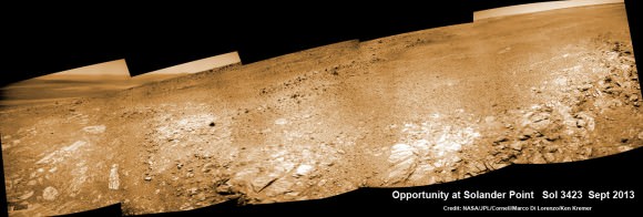
Opportunity scans Solander Point from a slope at the northern tip as she circles around the surrounding bench.  This navcam camera mosaic was assembled from raw images taken on Sol 3423 (Sept. 2013).  Credit: NASA/JPL/Cornell/Marco Di Lorenzo/Ken Kremer
Opportunity scans Solander Point from a slope at the northern tip as she circles around the surrounding bench. This navcam camera mosaic was assembled from raw images taken on Sol 3423 (Sept. 2013). Credit: NASA/JPL/Cornell/Marco Di Lorenzo/Ken Kremer

The rover recently investigated an outcrop target called ‘Poverty Bush’. She deployed her 3 foot long (1 meter) robotic arm and collected photos with the Microscopic Imager (MI) and collected several days of spectral measurements with the Alpha Particle X-ray Spectrometer (APXS).

Thereafter she resumed driving to the west/northwest around Solander.

“On September 13, Opportunity finally landed on the bed rock of Solander Point,” wrote Larry Crumpler, a science team member from the New Mexico Museum of Natural History & Science, in his latest field report about the MER mission.

“The terrain right here is awesome,” according to Crumpler.

“There are several geologic units that are overlapping here. And Opportunity is sitting on the contact.”

“On the east side of the contact are rocks maybe a billion years older than those on the west side of the contact. This sort of age progression is what geologists look for when trying to understand the past by reading the rocks.”

“Opportunity is allowing us for the first time to do not only fundamental geographic exploration, but it is enabling on the ground geologic study of past climatic history on Mars,” notes Crumpler.

Today marks Opportunity’s 3441st Sol or Martian Day roving Mars – for what was expected to be only a 90 Sol mission.
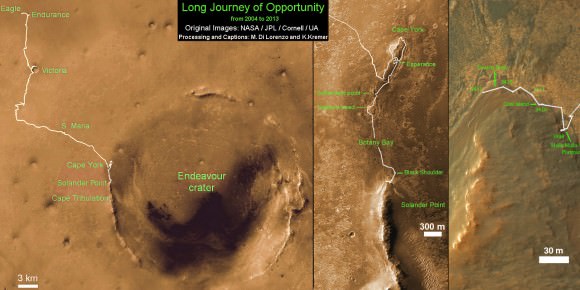
Traverse Map for NASA’s Opportunity rover from 2004 to 2013.  This map shows the entire path the rover has driven during more than 9 years and over 3431 Sols, or Martian days, since landing inside Eagle Crater on Jan 24, 2004 to current location at foothills of Solander Point at the western rim of Endeavour Crater.  Rover is now ascending Solander.  Opportunity discovered clay minerals at Esperance - indicative of a habitable zone.  Credit: NASA/JPL/Cornell/ASU/Marco Di Lorenzo/Ken Kremer
Traverse Map for NASA’s Opportunity rover from 2004 to 2013
This map shows the entire path the rover has driven during more than 9 years and over 3431 Sols, or Martian days, since landing inside Eagle Crater on Jan 24, 2004 to current location at foothills of Solander Point at the western rim of Endeavour Crater. Rover is now ascending Solander. Opportunity discovered clay minerals at Esperance – indicative of a habitable zone. Credit: NASA/JPL/Cornell/ASU/Marco Di Lorenzo/Ken Kremer

So far she has snapped over 184,500 amazing images on the first overland expedition across the Red Planet.

Her total odometry stands at over 23.82 miles (38.34 kilometers) since touchdown on Jan. 24, 2004 at Meridiani Planum.

Meanwhile on the opposite side of Mars, Opportunity’s younger sister rover Curiosity is trekking towards gigantic Mount Sharp and just discovered water altered pebbles at the intriguing ‘Darwin’ outcrop.

And NASA is in the final stages of processing of MAVEN, the agencies next orbiter, scheduled to blast off from Cape Canaveral on Nov.18 – see my upcoming up close article.

Ken Kremer

…………….

Learn more about Curiosity, Mars rovers, MAVEN, Orion, Cygnus, Antares, LADEE and more at Ken’s upcoming presentations

Oct 3: “Curiosity, MAVEN and the Search for Life on Mars – (3-D)”, STAR Astronomy Club, Brookdale Community College & Monmouth Museum, Lincroft, NJ, 8 PM

Oct 8: NASA’s Historic LADEE Lunar & Antares/Cygnus ISS Rocket Launches from Virginia”; Princeton University, Amateur Astronomers Assoc of Princeton (AAAP), Princeton, NJ, 8 PM

NASA’s MAVEN Mars orbiter, chief scientist Prof. Bruce Jakosky of CU-Boulder and Ken Kremer of Universe Today inside the cleanroom at the Kennedy Space Center on sept 27, 2013. MAVEN launches to Mars on Nov. 18, 2013 from Florida. Credit: Ken Kremer/kenkremer.com
NASA’s MAVEN Mars orbiter, chief scientist Prof. Bruce Jakosky of CU-Boulder and Ken Kremer of Universe Today inside the cleanroom at the Kennedy Space Center on Sept. 27, 2013. MAVEN launches to Mars on Nov. 18, 2013 from Florida. Credit: Ken Kremer/kenkremer.com

Comet ISON Goes Green

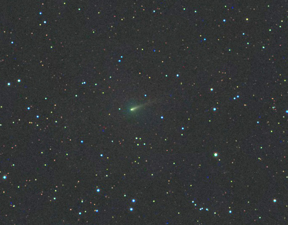
Comet ISON, photographed with a 3-inch (80mm) telescope on this morning Sept. 28 shows a circular green coma and short dust tail pointing northwest. Click to enlarge. Credit: Michael Jaeger

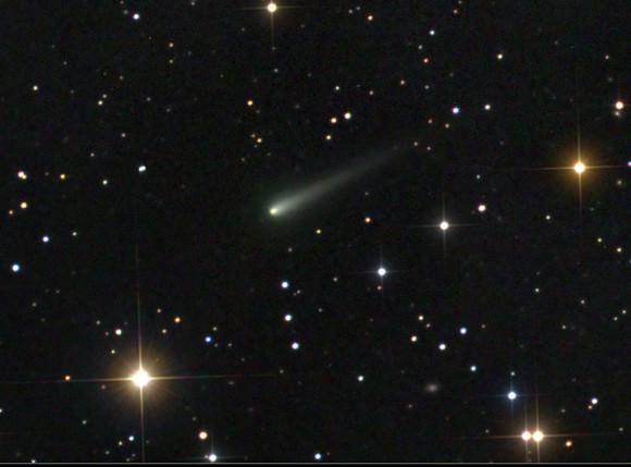
As NASA and the European Space Agency prepare  their remote photojournalists – Mars Express, Mars Reconnaissance Orbiter and the Curiosity and Opportunity rovers – to capture photos of Comet ISON’s flyby of Mars early next week, amateur astronomers continue to monitor and photograph the comet from backyard observatories across the blue Earth. Several recent color photos show ISON’s bright head or nucleus at the center of  a puffy, green coma. Green’s a good omen – a sign the comet’s getting more active as it enters the realm of the inner solar system and sun’s embrace.

Another  photo of a "greening" Comet ISON taken on Sept. 24 with a 17-inch (43-cm) telescope. Click to enlarge. Credit: Damian Peach
Another great photo of the “greening” of Comet ISON taken on Sept. 24 with a 17-inch (43-cm) telescope. Click to enlarge. Credit: Damian Peach

Sunlight beating down on the comet’s nucleus (core) vaporizes dust-impregnated ice to form a cloud or coma, a temporary atmosphere of water vapor, dust, carbon dioxide, ammonia and other gases. Once liberated , the tenuous haze of comet stuff rapidly expands into a huge spherical cloud centered on the nucleus. Comas are typically hundreds of thousands of miles across but are so rarified you could wave your hand through one and not feel a thing. The Great Comet of 1811 sported one some 864,000 miles (1.4 million km) across, nearly the same diameter as the sun!

Among the materials released by solar heating are cyanogen and diatomic carbon. Both are colorless gases that fluoresce a delicious candy-apple green when excited by energetic ultraviolet light in sunlight.

Sounds like a plan. Newspaper clipping from 1910.

Cyanogen smells pleasantly of almonds, but it’s a poisonous gas composed of one atom each of carbon and nitrogen. Diatomic carbon or C2 is equally unpleasant. It’s a strong, corrosive acid found not only in comets but also created as a vapor in high-energy electric arcs. But nature has a way of taking the most unlikely things and fashioning them into something beautiful. If you’re concerned about the effects of cometary gas and dust on people, rest easy. They’re spread too thinly to touch us here on Earth. That didn’t stop swindlers from selling “comet pills” and gas masks to protect the public from poisoning during the 1910 return of Halley’s Comet. Earth passed through the tail for six hours on May 19 that year. Amazingly, those who took the pills survived … as did everyone else.

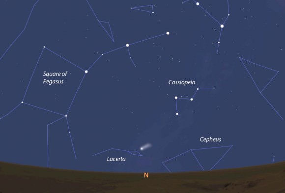
Comet ISON's location and approximate appearance on October 1 seen from the Curiosity Rover. ISON will pass only 6.7 million miles (10.8 million km) from Mars on Tuesday Oct. 1. Stellarium
Comet ISON’s location and approximate appearance on October 1 seen from the Curiosity Rover. ISON will pass only 6.7 million miles (10.8 million km) from Mars on Tuesday Oct. 1. Stellarium

While Comet ISON is still too faint for visual observers to discern its Caribbean glow, that will change as it beelines for the sun and brightens. If you could somehow wish yourself to Mars in the next few days, I suspect you’d easily see the green coma through a telescope. The comet – a naked eye object at magnitude 2.5-3 – glows low in the northern sky from the Curiosity rover’s vantage point 4.5 degrees south of the Martian equator.

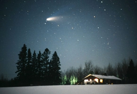
Comet Hale-Bopp shows off its whitish dust tail and fainter, blue ion tail in early 1997. Credit: Bob King
Comet Hale-Bopp shows off its bright dust tail and fainter, blue ion tail in early spring 1997. Credit: Bob King

I’ve noticed that when a comet reaches about 7th magnitude, the green coloration becomes apparent in 8-inch (20 cm) and larger telescopes. Bright naked eye comets often display multiple subtle colors that change chameleon-like over time. Dust tails, formed when sunlight pushes dust particles downwind from the coma, glow pale yellow. Gusty solar winds sweep back molecules from the coma into a second “ion” tail that glows pale blue from jazzed up carbon monoxide ions fluorescing in solar UV.

The highlight of seeing the comet through the telescope was its brilliant, pea-like false nucleus glowing yellow from sunlit dust. The real comet nucleus – the actual comet – lies within the false nucleus and shrouded by dust. Drawing: Bob King
One of the highlights of seeing Comet L4 PANSTARRS through a small telescope was its brilliant, pea-like false nucleus glowing yellow from sunlit dust. The real comet nucleus – the actual comet – lies within the false nucleus and hidden by dust. Drawing: Bob King

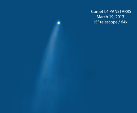
During close encounters with the sun, millions of pounds of  dust per day boil off a comet’s nucleus, forming a small, intensely bright, yellow-orange disk in the center of the coma called a false nucleus. Earlier this year, when Comet C/2011 L4 PANSTARRS emerged into the evening sky after perihelion, not only was its yellow tail apparent to binocular users but the brilliant false nucleus glowed a lovely shade of lemon in small telescopes.

With ISON diving much closer to the sun than L4 PANSTARRS, expect a full color palette in the coming weeks. While it may not be easy being green for Sesame Street’s Kermit the Frog, comets do it with aplomb.

Pakistan’s “Earthquake Island” Seen From Space

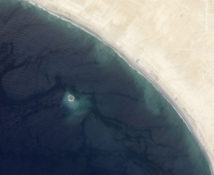
Mud island off the coast of Gwadar imaged by NASA's EO-1 satellite on Sept. 26, 2013

On the afternoon of Tuesday September 24, 2013, a 7.7-magnitude earthquake struck Balochistan province in southern Pakistan, causing widespread destruction across several districts during more than 2 minutes of powerful tremors and shaking. Sadly at least 400 people were killed (some reports say 600) and over 100,000 have been left homeless. But a weirder — if much less tragic — effect of the quake that was soon reported worldwide was the sudden appearance of a new island off the coast, a mound of mud and bubbling methane seeps rising nearly 20 meters (70 feet) from the ocean surface.

The image above, taken by NASA’s Earth Observing-1 satellite, shows the newly-formed mud island a kilometer (0.6 miles) off the Gwadar coast.

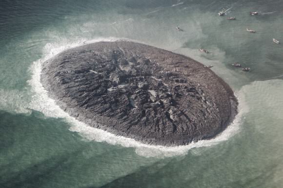
According to an article by the Pakistani news site Dawn.com, the 250-by-100-foot-long pile of mud and rocks is leaking flammable gases.

“Our team found bubbles rising from the surface of the island which caught fire when a match was lit and we forbade our team to start any flame,” said Mohammad Danish, a marine biologist from Pakistan’s National Institute of Oceanography. “It is methane gas.”

Aerial photo of the Gwadar mud volcano (National Institute of Oceanography, Pakistan)

Pakistan’s many earthquakes are the result of collisions between the Indian, Arabian, and Eurasian tectonic plates. These sorts of mud volcanoes are not particularly unusual after large quakes there… it just so happened that this one occurred near a populated coast and in relatively shallow water. (Source)

(In fact two days later another mud island was spotted off the coast of the nearby coastal town of Ormara.)

The mud volcano, which is being called “Zalzala Jazeera” (earthquake island) is not expected to last long. Wave action will eventually sweep the sediment away over the course of several months. (Dawn.com.)

Unfortunately earthquake relief efforts in the remote Taliban-dominated region are being hampered by militant activity.

Image source: NASA Earth Observatory

Watch Live on September 29: Orbital’s Cygnus Capsule Rendezvous with ISS

Artist rendering of Cygnus spacecraft approaching the International Space Station. Credit: Orbital Sciences Corp.

NASA and Orbital Sciences Corporation have announced a new date and time for the targeted arrival and berthing of the Cygnus spacecraft for its demonstration cargo resupply mission to the International Space Station. All the action will now take place on Sept. 29, a week later than originally planned, after a software glitch on the first rendezvous attempt, and a subsequent scheduling conflict due to the arrival of a Soyuz spacecraft with additional crew.

You can see the schedule of events below, as well as watch live on NASA TV’s UStream feed:

Here’s the current schedule of the Cygnus rendezvous, grapple and berthing activities, but check this link for any updates or changes:

Sunday, September 29

08:30 UTC (4:30 a.m. EDT: Cygnus rendezvous, grapple and berthing coverage begins on NASA Television.

11:15 UTC (7:15 a.m. EDT): Grapple of Cygnus by International Space Station’s Canadarm2 robotic arm
13:15 UTC (9:15 a.m. EDT): Cygnus berthing to Earth-facing port of Harmony node begins
17:00 UTC (1 p.m. EDT): Cygnus Post-Capture News Conference


Live streaming video by Ustream

ISS astronauts Karen Nyberg and Luca Parmitano are scheduled to grapple Cygnus with the station’s Canadian built robotic arm, working from the robotic work station in the Cupola module. They will install the cargo carrier at an Earth-facing docking port on the Harmony pressurized module.

Cygnus will deliver about 1,300 pounds (589 kilograms) of cargo, including student experiments, food and clothing, to the space station. Future Cygnus flights will ensure a robust national capability to deliver critical science research to orbit, significantly increasing NASA’s ability to conduct new science investigations to the only laboratory in microgravity.

Weekly Space Hangout – September 27, 2013: Buran, Comet ISON, Water on Mars

Is it Friday already? Then it’s time for another Weekly Space Hangout. Join a team of dedicated space journalists to discuss the big space and astronomy news stories that broke this week. This time around, we discussed Amy Shira Teitel’s Buran article, ISON Watch 2013, and the re-re-discovery of water on Mars.

Host: Fraser Cain

Journalists: Amy Shira Teitel, David Dickinson, Jason Major, Dr. Nicole Gugliucci, and Scott Lewis.

And here are the stories we covered:

The Life and Death of Buran
Comet ISON Viewing Guide
Water on Mars
Split Personality Pulsar
Asteroid Was Actually Space Junk
Cat’s Paw Nebula in APEX
Spitzer for Exoplanets
Mindblowing Spaceship Chart

We record the Weekly Space Hangout every Friday at 12:00 pm Pacific / 3:00 pm Eastern, 2000 GMT. You can watch from here on Universe Today, or over on Google+ or YouTube.

NASA Astronaut Helped Actors Prepare for “Gravity”

Sandra Bullock as Ryan Stone in Warner Bros. Pictures' dramatic thriller "Gravity," a Warner Bros. Pictures release. Image Credit: Courtesy of Warner Bros. Pictures

Actors for a new movie coming out in October 2013 received tips about life in space from NASA astronaut Cady Coleman. “Gravity” is the story of two astronauts (played by George Clooney and Sandra Bullock) whose shuttle is destroyed by a run-in with space junk during an EVA, stranding them both in orbit and struggling for survival.

While developing her role, Bullock gave Coleman a call while she was aboard the space station. At the time, the actress asked Coleman to elaborate on what it’s like living and moving about in microgravity. “I told her that I had long hair, and if you pulled a hair out and pushed it against something, you could move yourself across the space station,” said Coleman. “That’s how little force it takes.”

You can see more of their discussion below, as well as the heart-pounding trailer for the movie:

NASA says that although this dire scenario makes for gripping Hollywood entertainment, NASA actively works to protect its astronauts and vehicles from the dangers portrayed in the movie. From protective shielding and meticulous and methodical training on the ground and in space covering everything from spacewalking to fires or decompression inside the space station, NASA’s ground crews and astronauts are as prepared as they can be for potential anomaly, no matter how remote they may be.

Read more about aspects of the International Space Station that you’ll see in the movie in this feature article from NASA.

How Do Black Holes Form?

How Do Black Holes Form?

Black holes are the most exotic and awe inspiring objects in the Universe.

Take the mass of an entire star. Compress it down into an object so compact that the force of gravity defies comprehension.

Nothing, not even light, can escape the pull of gravity from a black hole.

The idea was first conceived in the 18th century by the geologist John Mitchell. He realized that if you could compress the Sun down by several orders of magnitude, it would have gravity so strong that you’d need to be going faster than the speed of light to escape it.

Initially, black holes were considered nothing more than abstract mathematical concepts; even Einsten assumed they didn’t actually exist. But in 1931, the astronomer Chandrasekhar calculated that certain high mass stars might be able to collapse into black holes after all.

They turned out to be real, and over the next few decades, astronomers found many examples out in the Universe.

Stars are held in perfect balance by two opposing forces. There’s the inward pressure of gravity, attempting to collapse the star, counteracted by the outward pressure of the emitted radiation.

This artist's concept illustrates a supermassive black hole with millions to billions times the mass of our sun. Supermassive black holes are enormously dense objects buried at the hearts of galaxies. Image credit: NASA/JPL-Caltech
This artist’s concept illustrates a supermassive black hole with millions to billions times the mass of our sun. Supermassive black holes are enormously dense objects buried at the hearts of galaxies. Image credit: NASA/JPL-Caltech
At the core, millions of tonnes of hydrogen are being converted into helium every second, releasing gamma radiation. This fusion process is an exothermic reaction, meaning it releases more energy than it requires.

As the star consumes the last of its hydrogen, it switches to the stockpiles of helium that it has built up. After it runs out of helium, it switches to carbon, and then oxygen.

Since the star continues to pump out radiation, it balances out the gravitational forces trying to compress it.

eso1244aStars with the mass of our Sun pretty much stop there. Not massive enough to continue the fusion reaction, beyond oxygen, they become a white dwarf and cool down.

But for stars with about 5 times the mass of our Sun, the fusion process continues further up the periodic table to silicon, aluminum, potassium, and so on, all the way to iron.

No energy can be produced by fusing iron atoms together. It’s the stellar equivalent of ash.

A supernova remnant and pulsar located 6000 light years from Earth.And so, in a fraction of a second, the radiation from the star turns off. Without that outward pressure from the radiation, gravity wins out and the star implodes. An entire star’s mass collapses down into a smaller and smaller volume of space.

The velocity you would need to escape from the star goes up, until not even light is going fast enough to escape.

And this is how you form a black hole.

Well, that’s the main way.

You can also get black holes when dense objects, like neutron stars, collide with one another.

And then there are the supermassive black holes at the heart of every galaxy. And to be honest, astronomers still don’t know how those monsters formed.

A Mindblowing Spaceship Chart Every Sci-Fi Fan Needs to See

This chart provides and accurate size comparison for every science fiction starship imaginable. Credit: Dirk Loechel. Click for original large version.

Have you always wanted to know how a Xurian Scout Fighter compares to a Valor-class Type-2 Valkyrie Attack Fighter? Wonder no more. DeviantARTist Dirk Loechel has created what is likely the most accurate and complete size comparison chart of almost every science fiction starship, from famous Star Trek and Stars Wars battle cruisers to ships from games like Halo to vessels from obscure sci-fi books. This new chart is an updated version of one Loechel made earlier. It looks like Loechel is taking suggestions for doing another update if you find he’s missed some.

Click on the image above to have access to the large original version on DeviantART, and enjoy the diversion.

Dinosaurs in Spaaaace!

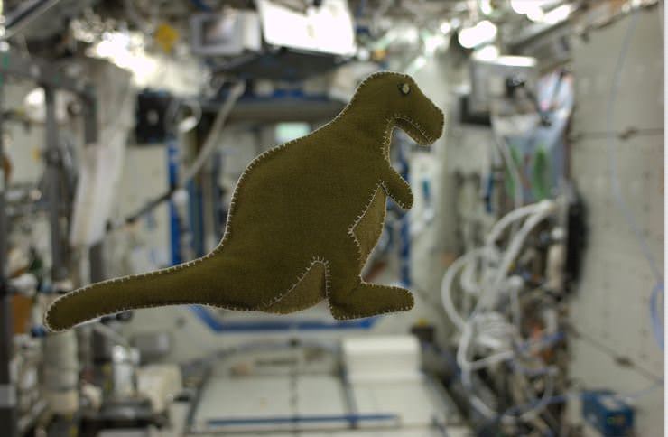
While on the ISS, astronaut Karen Nyberg made this dinosaur for her son, created from reclaimed velcro-like fabric that lines the Russian food containers. Credit: Karen Nyberg via Pinterest.

Astronaut Karen Nyberg wins Pinterest. Not only has she made her 3-year old son a dinosaur toy, she created it while IN SPACE, and scored a super-coup by making it from the reclaimed velcro-like fabric that lines the Russian food containers on the International Space Station. Nyberg said the dinosaur is stuffed with scraps from a used t-shirt.

Upcycling in space … wow. She’s clearly now outdone every crafter both on and off the planet. As one commenter on Pinterest said, “How awesome to have someone promoting/demonstrating crafting, science and education and a mother’s love from the ISS!”

You can see more of Nyberg’s handiwork while she’s been in space, as well as pictures she’s taken of planet Earth, the science experiments she’s doing and more on her Pinterest page. She will be on the ISS until November 11.

This Earth-Like Mars Rock Shows Diversity of Red Planet Geology

The rock chosen for the first contact science investigations for the Curiosity rover. Credit: NASA/JPL-Caltech

A strange rock encountered by the Mars Curiosity rover early in its mission has few similarities to other rocks found on the Red Planet, a new study says. In fact, the “Jake_M” rock is most similar to a rare kind of Earth rock called a mugearite, which is often found in ocean islands and continental rift zones.

“Such rocks are so uncommon on Earth that it would be highly unlikely that, if you landed a spacecraft on Earth in a random location, the first rock you encountered within a few hundred meters of your landing site would be an alkaline rock like Jake_M,” stated Edward Stolper, a geology professor at the California Institute of Technology.

Jake_M is named after Jacob “Jake” Matijevic, a Curiosity operations systems chief engineer who died two weeks after the rover landed last year. The rock was sampled about two weeks after Curiosity hit the surface, and was revealed to have sodium and potassium in it (which makes it chemically alkaline.)

The NASA team threw in every bit of data they could to model the Mars Curiosity landing. Credit: NASA

It’s probable that the rock came to be, the scientists said, after partially melting in the interior of Mars and then coming up to the surface. “As it cooled, crystals formed, and the chemical composition of the remaining liquid changed (just as, in the making of rock candy, a sugar-water solution becomes less sweet as it cools and sugar crystallizes from it),” CalTech stated.

Models examining the formation conditions suggest that Jake_M originated from an area some tens of miles or kilometers in the interior of Mars relative to the surface, and that the magma  it formed in might have had a reasonably high proportion of dissolved water. This type of magma (called alkaline magma) is uncommon on Earth, but may be more common on Mars than previously believed.

You can read more details about the rock, as well as a series of four other papers published about science from MSL in the Sept. 27 edition of Science.

Source: CalTech