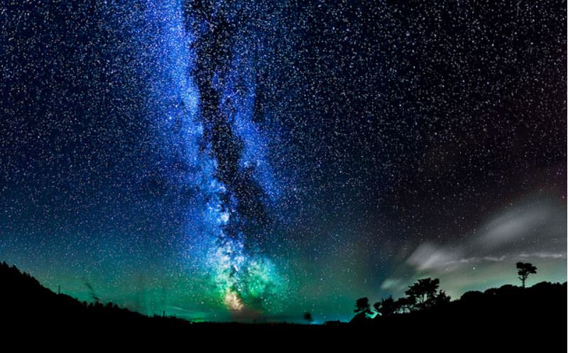
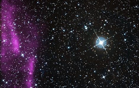
A night sky over the Isle of Wight that is bright with the Milky Way and green airglow. Credit and copyright: Chad Powell.
Here’s a beautiful view of the Milky Way arching through the sky over the Isle of Wight, an island just off the south coast of England, known for having limited light pollution. This gorgeous image was taken by photographer Chad Powell. You can see more of Chad’s work on his website or his Facebook page.
Want to get your astrophoto featured on Universe Today? Join our Flickr group or send us your images by email (this means you’re giving us permission to post them). Please explain what’s in the picture, when you took it, the equipment you used, etc.
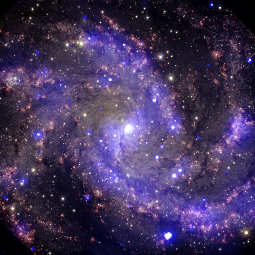
Composite image of NGC 6946, a spiral galaxy 22 million light years from Earth. At least eight supernova have exploded in this galaxy in the past century, including three spotted by Chandra (purple). Optical data is also visible in red, yellow and cyan from the Gemini Observatory. Credit: X-ray: NASA/CXC/MSSL/R.Soria et al, Optical: AURA/Gemini OBs
You know that moment when you’re flipping through old digital pictures (on your computer or phone or whatever) and you realize there are some pretty awesome ones in there that you should share on social media? The Chandra X-Ray Observatory team also decided to plumb THEIR archive of astrophysical image magic, and came up with several beauties. Such as the one above this text.
Chandra has been in space since July 23, 1999 — yes, that’s well over 14 years ago — and is considered one of NASA’s telescopes under the “Great Observatories” programs. The other telescopes, by the way, are the Hubble Space Telescope, the Compton Gamma-Ray Observatory and the Spitzer Space Telescope. Hubble and Spitzer are also still active today.
Check out more from the new set of images below. There are eight all told, representing a tiny fraction of the unprocessed thousands of images available to the public in the Chandra Source Catalog.
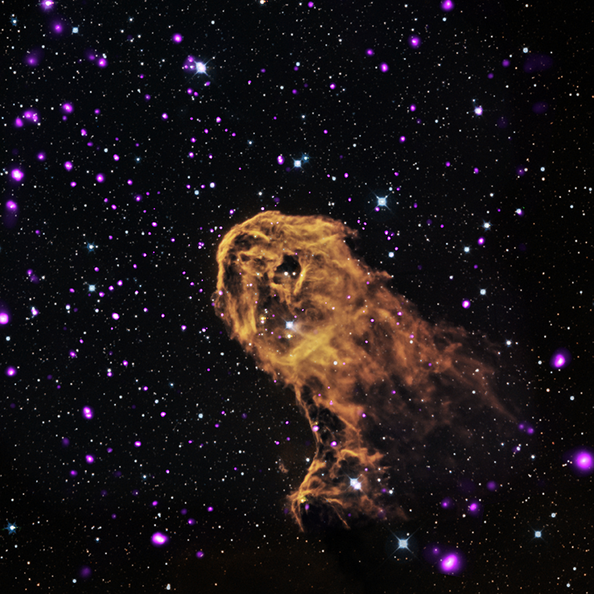
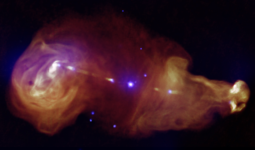
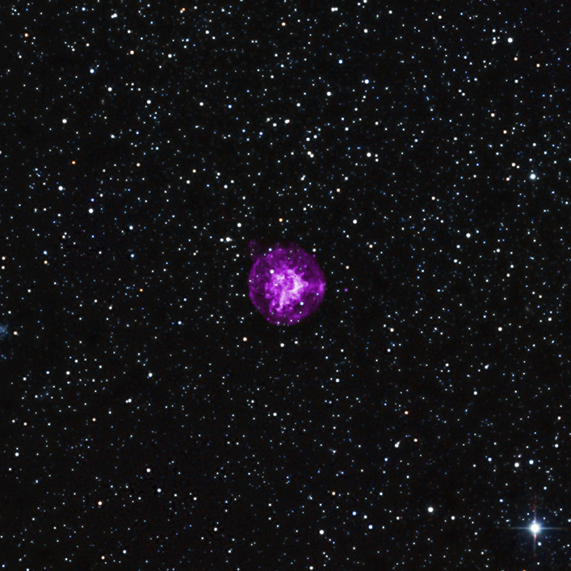
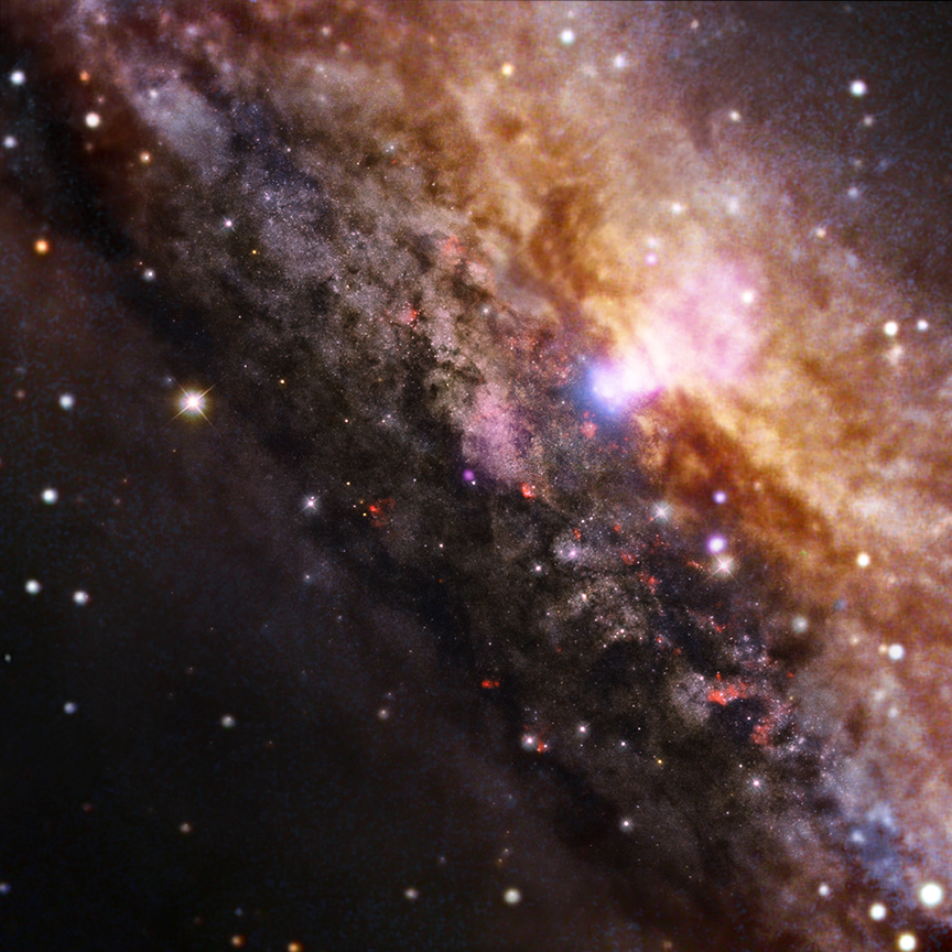
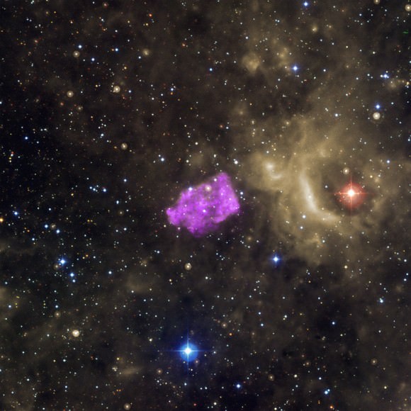
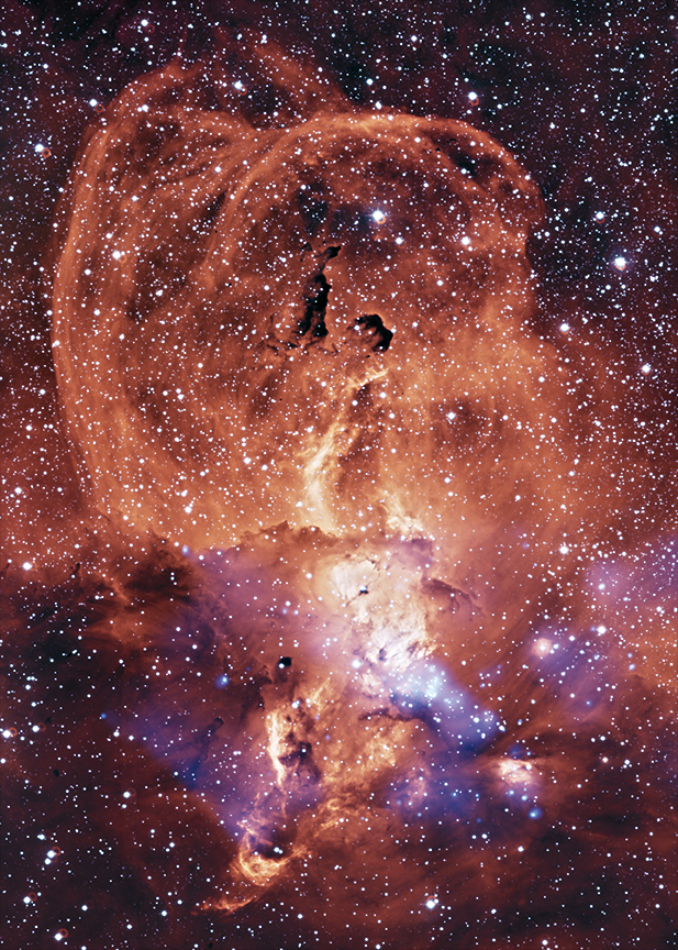
The Elephant Trunk Nebula (IC 1396A) in X-ray, optical and infrared light. Astronomers believe they are seeing winds from large, young stars hitting cooler gas around it, possibly triggering new starbirth. X-ray data from Chandra is in purple, with optical data (red, green and blue) and infrared (orange and cyan). Credit: X-ray: NASA/CXC/PSU/Getman et al, Optical: DSS, Infrared: NASA/JPL-Caltech3C353 looks a bit like a tadpole. In the center of this image is a galaxy powered by a supermassive black hole, which is transmitting energy across the expanse. Radiation is visible in X-rays from Chandra (purple) and radio from the Very Large Array (orange.) Credit: X-ray: NASA/CXC/Tokyo Institute of Technology/J.Kataoka et al, Radio: NRAO/VLASNR B0049-73.6 in X-ray and infrared light. Chandra’s observations (purple) revealed that the explosion seen here was likely from a star’s central core collapse. Infrared data from the 2MASS survey is also visible in red, green and blue. Credit: X-ray: NASA/CXC/Drew Univ/S.Hendrick et al, Infrared: 2MASS/UMass/IPAC-Caltech/NASA/NSFNGC 4945, a galaxy 13 million light years from Earth. This galaxy is similar to the Milky Way, but has a more active supermassive black hole in the center (visible in white). Chandra X-ray data is in blue, overlaid on European Space Observatory optical information. Credit: X-ray: NASA/CXC/Univ degli Studi Roma Tre/A.Marinucci et al, Optical: ESO/VLT & NASA/STScI3C 397, sometimes called G41.1-0.3, is a supernova leftover that looks a little funny. It’s possible that the shape comes from heated remains of the star’s shell bump into cooler gas surrounding it. X-ray data from Chandra is purple, infrared data from the Spitzer Space Telescope is yellow, and optical data from the Digitized Sky Survey is in red, green and blue. Credit: X-ray: NASA/CXC/Univ of Manitoba/S.Safi-Harb et al, Optical: DSS, Infrared: NASA/JPL-CaltechNGC 3576, a nebula 9,000 light-years from Earth, in X-ray (blue) and optical data. Chandra spotted evidence of strong winds coming from young stars in the nebula. Optical data from the European Space Observatory is shown in orange and yellow. Credit: X-ray: NASA/CXC/Penn State/L.Townsley et al, Optical: ESO/2.2m telescopeG266.2-1.2 in X-ray (purple) and optical light. Chandra spotted high-energy particles shooting out from this supernova leftover. The optical data comes from the Digitized Sky Survey and is available in red, green, and blue. Credit: X-ray: NASA/CXC/Morehead State Univ/T.Pannuti et al, Optical: DSS
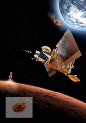
A European Space Agency-designed container that could be used one day to bring Martian samples back to Earth. Credit: ESA-Anneke Le Floc'h
Could this be as surprising as Forrest Gump’s box of chocolates? What you’re looking at here is a container that could one day contain samples of Mars. Yup, even though a “sample return” mission is still years away, the European Space Agency is already designing a container so that when the time comes, they’ll be ready for the trip.
This 11-pound (five kilogram) container absolutely needs to keep whatever is inside protected and at a constant temperature of 14 Fahrenheit (-10 Celsius) as it journeys from the Martian surface to Earth, which takes several months at the least. And the journey won’t be an easy one, ESA says:
“First, the sample container must be landed on Mars, along with a rover to retrieve a cache of samples carefully selected by a previous mission, according to current mission scenarios,” the agency stated.
A Mars sample return mission is still quite a ways away. Credit: European Space Agency
“Then, once filled, it will be launched back up to Mars orbit. There it will remain for several days until a rendezvous spacecraft captures it … Before being returned to Earth, the container will be enclosed in another larger bio-sealed vessel to ensure perfect containment of any returned martian material. This container will then be returned to Earth for a high-speed entry.”
Why not use a parachute? Well, if the samples contain life it would be awkward if the parachute malfunctioned and the capsule scattered stuff all over Earth. That’s why it’s designed for a crash landing; it can in fact withstand forces of at least 400 times the force of gravity, tests of the capsule have revealed.
The prime contractor for this project was French company Mecano I&D. ESA emphasizes this is just a proof of concept so far, and that further refinements are expected. Plus, this little machine needs a ride to and from Mars. When do you think that will happen, and how?
Artist's conception of a comet exploding in the Earth’s atmosphere above Egypt. Credit: Terry Bakker
Speak about destruction. A comet slammed into Earth’s atmosphere 28 million years ago and basically killed everything with fire below, leaving a huge deposit of yellow silica glass in its wake, a team of astronomers say.
The evidence — a black pebble found by an Egyptian geologist within this vast tract of glass — is believed to be a part of the comet’s nucleus or heart and not just an ordinary meteorite. The team says this could be the first hard evidence, so to speak, of a comet striking Earth.
The temporary “shockwave of fire” hit 2,300 square miles (roughly 6,000 square kilometers) of Egyptian sand, turning the grains into glass. Given the area’s rich archaeological history, it’s probably not too much of a surprise that a small portion of this is visible in a brooch that belonged to ancient boy-king Tutankhamun.
A brooch that belonged to the Egyptian boy-king Tutankhamun, which reportedly contains a silica glass stone that originated from a comet explosion. Credit: University of the Witwatersrand, Johannesburg
“It’s a typical scientific euphoria when you eliminate all other options and come to the realization of what it must be,” said lead author Jan Kramers of the University of Johannesburg in a statement.
Besides silica, the cosmic blast furnace left teeny-tiny diamonds in its wake, forming from carbon. “Normally they form deep in the earth, where the pressure is high, but you can also generate very high pressure with shock. Part of the comet impacted and the shock of the impact produced the diamonds,” said Kramers.
More information on this find should be available soon when the discovery is published in Earth and Planetary Science Letters. The authors first discussed their find in a public lecture Oct. 10. It will be interesting to see what other scientific teams think of this hypothesis, so stay tuned for the reaction.
Source: University of the Witwartersrand, Johannesburg
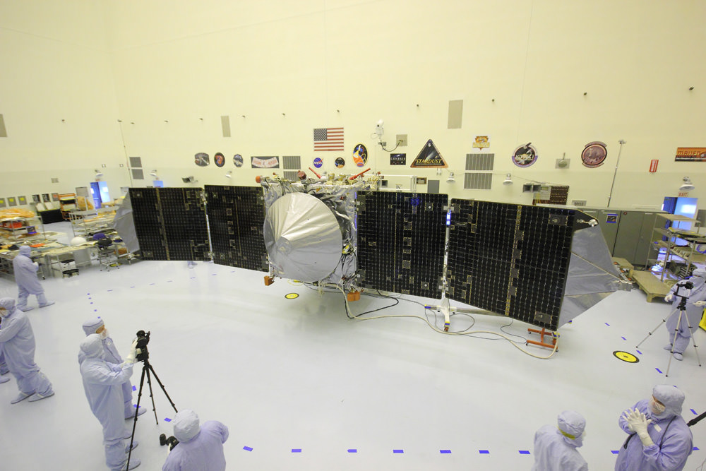
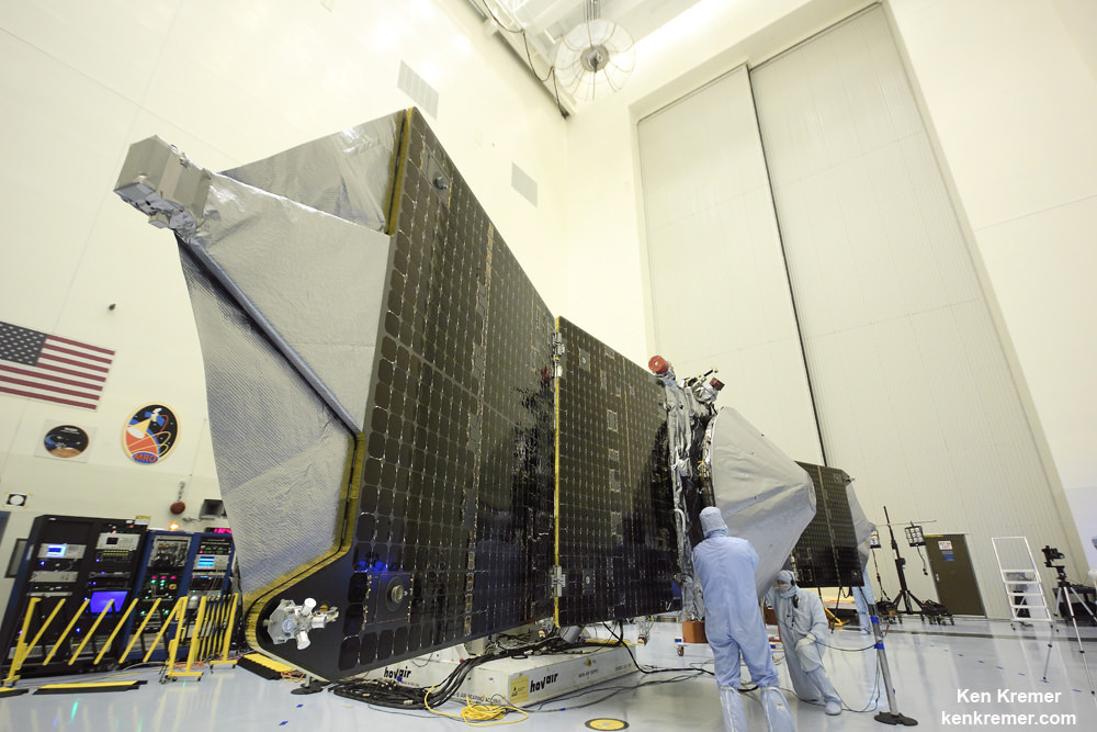
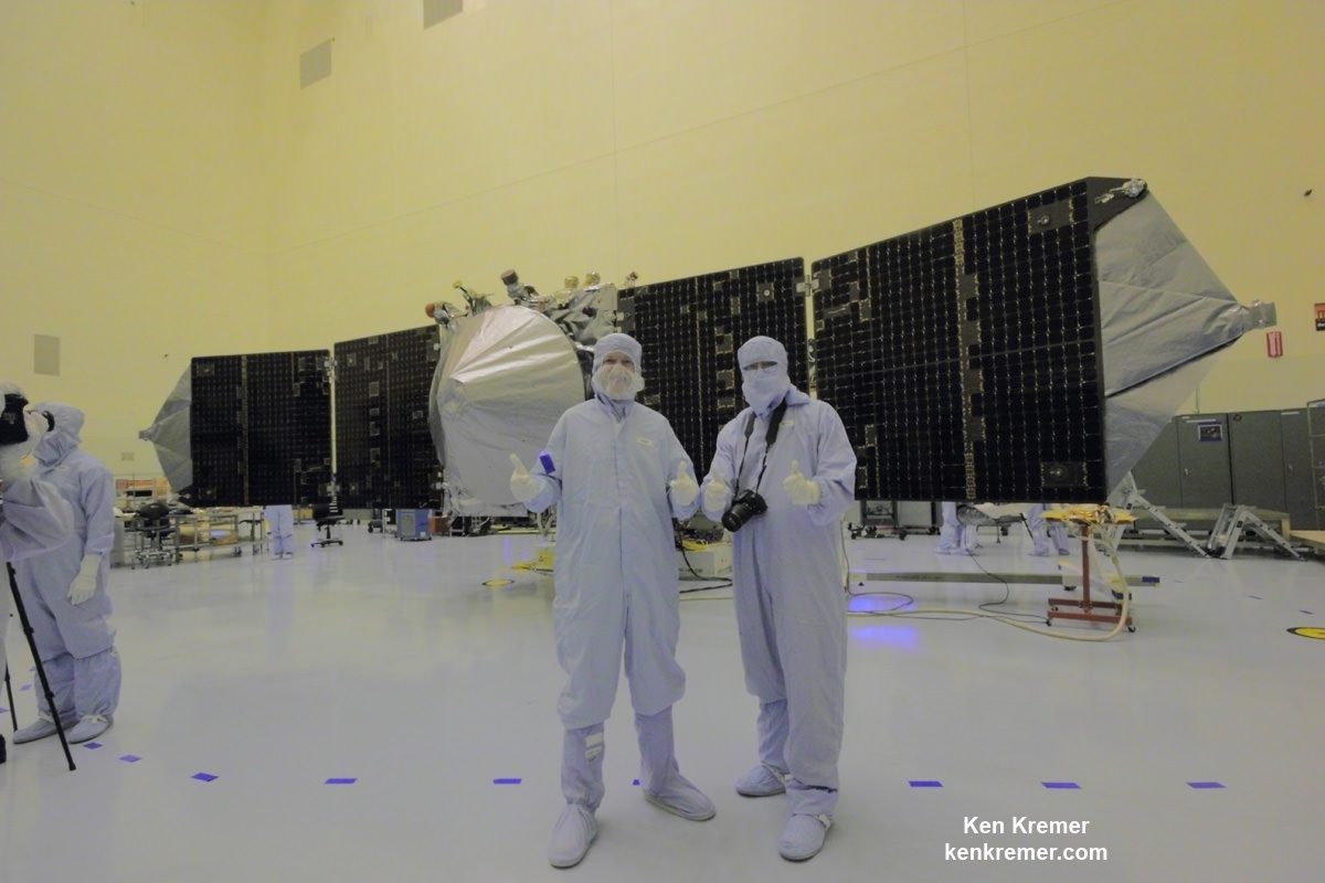
MAVEN is NASA’s next Mars orbiter and is due to blastoff on Nov. 18 from Cape Canaveral, Florida. It will study the evolution of the Red Planet’s atmosphere and climate. Universe Today visited MAVEN inside the clean room at the Kennedy Space Center. With solar panels unfurled, this is exactly how MAVEN looks when flying through space and circling Mars. Credit: Ken Kremer/kenkremer.com
After years of hard work by dedicated science and engineering teams, a new pair of Mars orbiter science missions from Earth are in the final stages of prelaunch processing and are nearly set to blast off for the Red Planet in November.
If all goes well, NASA’s MAVEN orbiter and India’s MOM (Mars Orbiter Mission) will “work together” to help solve the mysteries of Mars atmosphere, the chief MAVEN scientist told Universe Today at a NASA briefing today (Oct. 28).
“We plan to collaborate on some overlapping objectives,” Bruce Jakosky told me. Jakosky is MAVEN’s principal Investigator from the University of Colorado at Boulder.
MAVEN and MOM will join Earth’s armada of five operational orbiters and surface rovers currently exploring the Red Planet.
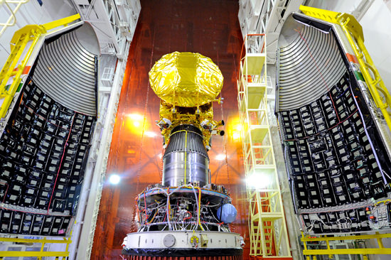
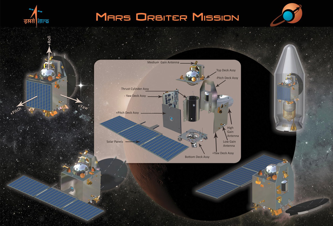
India’s Mars Orbiter Mission (MOM) Spacecraft attached to the 4th stage of PSLV-C25 and ready for heat shield closure. It is slated to launch on Nov. 5, 2013. Credit: ISRO
MOM is India’s first mission to Mars. Its also first in line to this year’s Martian on ramp and is slated to lift off in barely one week on Nov. 5 atop the most powerful version of the Polar Satellite Launch Vehicle (PSLV) rocket from a seaside launch pad in Srihanikota, India.
The 1,350 kilogram (2,980 pound) MOM orbiter, also known as ‘Mangalyaan’, is the brainchild of ISRO, the Indian Space Research Organization.
NASA’s Mars Atmosphere and Volatile EvolutioN Mission (MAVEN) spacecraft launches in three weeks on Nov. 18 atop a United Launch Alliance Atlas V 401 rocket from a seaside pad on Cape Canaveral Air Force Station, Florida.
Both MAVEN and MOM will study the Red Planets atmosphere. Although they are independent and carrying different science payloads the two missions do have some common goals.
“There are some overlapping objectives between MAVEN and MOM,” Jakosky said.
“We have had some discussions with the MOM science team.”
Magnetometer science instrument boom juts out from MAVEN solar panel during launch processing inside the clean room at the Kennedy Space Center. Credit: Ken Kremer/kenkremer.com
Both orbiters are due to arrive at Mars in September 2014 after 10 month interplanetary cruises and will enter different elliptical orbits after main engine braking burns.
MAVEN is the first spacecraft from Earth devoted to investigating and understanding the upper atmosphere of Mars.
The purpose is to study specific processes and determine how and why Mars lost virtually all of its atmosphere billions of years ago and what effect that had on the history of climate change and habitability.
“The major questions about the history of Mars center on the history of its climate and atmosphere and how that’s influenced the surface, geology and the possibility for life,” said Jakosky.
“MAVEN will focus on understanding the history of the atmosphere, how the climate has changed through time, and how that influenced the evolution of the surface and the potential for habitability by microbes on Mars.”
“We don’t know the driver of the change.”
“Where did the water go and where did the carbon dioxide go from the early atmosphere? What were the mechanisms?”
“That’s what driving our exploration of Mars with MAVEN,” said Jakosky.
One of the significant differences between MOM and MAVEN regards methane detection – which is a potential marker for Martian life. Some 90% of Earth’s atmospheric methane derives from living organisms.
MOM has a methane sensor but not MAVEN.
“We just had to leave that one off to stay focused and to stay within the available resources ,” Jakosky told me.
MAVEN carries nine sensors in three instrument suites.
The Particles and Fields Package, provided by the University of California at Berkeley with support from CU/LASP and NASA’s Goddard Space Flight Center in Greenbelt, Md., contains six instruments to characterize the solar wind and the ionosphere of Mars. The Remote Sensing Package, built by CU/LASP, will determine global characteristics of the upper atmosphere and ionosphere. The Neutral Gas and Ion Mass Spectrometer, built by Goddard, will measure the composition of Mars’ upper atmosphere.
MOM’s science complement comprises the tri color Mars Color Camera to image the planet and its two moons, Phobos and Deimos; the Lyman Alpha Photometer to measure the abundance of hydrogen and deuterium and understand the planets water loss process; a Thermal Imaging Spectrometer to map surface composition and mineralogy, the MENCA mass spectrometer to analyze atmospheric composition, and the Methane Sensor for Mars to measure traces of potential atmospheric methane down to the ppm level.
Graphic outlines India’s first ever probe to explore the Red Planet known as the Mars Orbiter Mission (MOM). Launch is set for Nov. 5 from the Satish Dhawan Space Centre SHAR, Srihairkota, India. Credit: ISRO
“At the point where we [MAVEN and MOM] are both in orbit collecting data we do plan to collaborate and work together with the data jointly,” Jakosky told me.
“We agreed on the value of collaboration and will hold real discussions at a later time,” he noted.
NASA is providing key communications and navigation support to ISRO and MOM through the agency’s trio of huge tracking antennas in the Deep Space Network (DSN).
Over the course of its one-Earth-year primary mission, MAVEN will observe all of Mars’ latitudes at altitudes ranging from 93 miles to more than 3,800 miles.
MAVEN will execute five deep dip maneuvers during the first year, descending to an altitude of 78 miles. This marks the lower boundary of the planet’s upper atmosphere.
MAVEN has sufficient fuel reserves on board to continue observations for more than a decade.
The spacecraft will function as an indispensible orbital relay by transmitting surface science data through the “Electra” from NASA’s ongoing Curiosity and Opportunity rovers as well as the planned 2020 rover.
Stay tuned here for continuing MAVEN and MOM news and my launch reports from on site at the Kennedy Space Center press center.
Learn more about MAVEN, Mars rovers, Orion and more at Ken’s upcoming presentations
Nov 15-19: “MAVEN Mars Launch and Curiosity Explores Mars, Orion and NASA’s Future”, Kennedy Space Center Quality Inn, Titusville, FL, 8 PM
NASA’s MAVEN Mars orbiter, chief scientist Prof. Bruce Jakosky of CU-Boulder and Ken Kremer of Universe Today inside the clean room at the Kennedy Space Center on Sept. 27, 2013. MAVEN launches to Mars on Nov. 18, 2013 from Florida. Credit: Ken Kremer/kenkremer.com
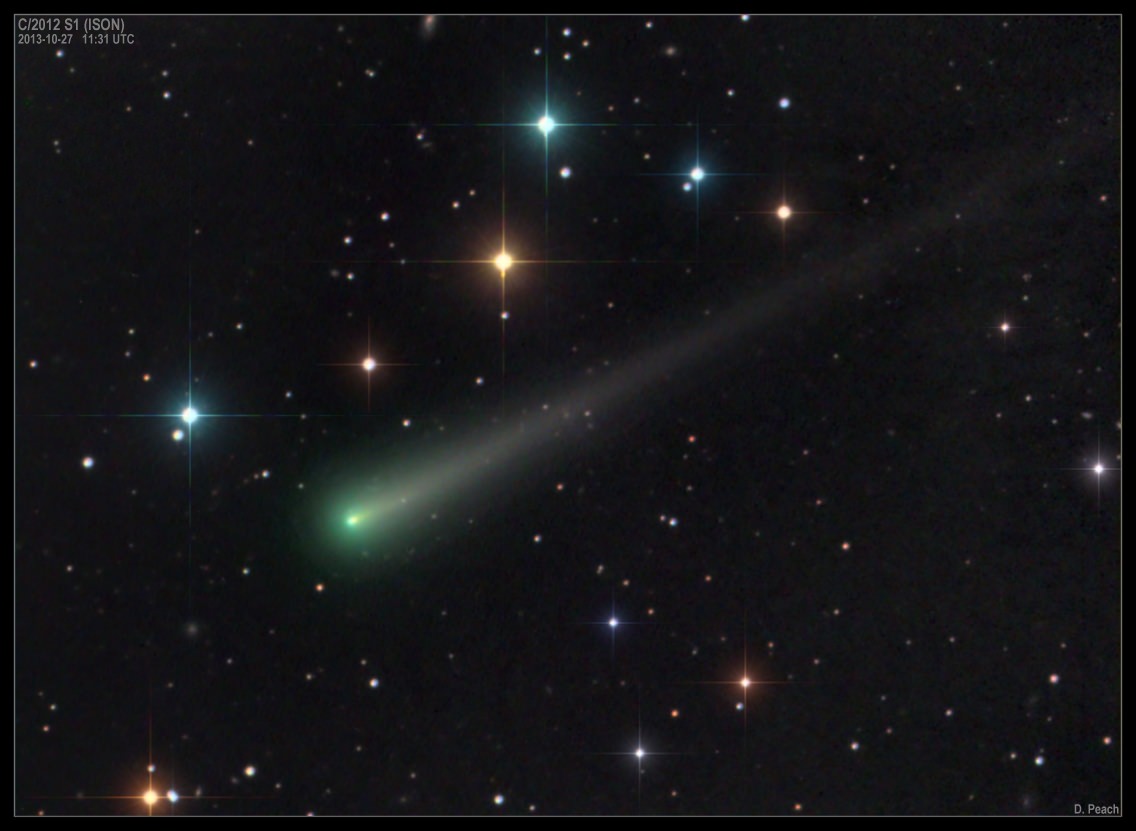
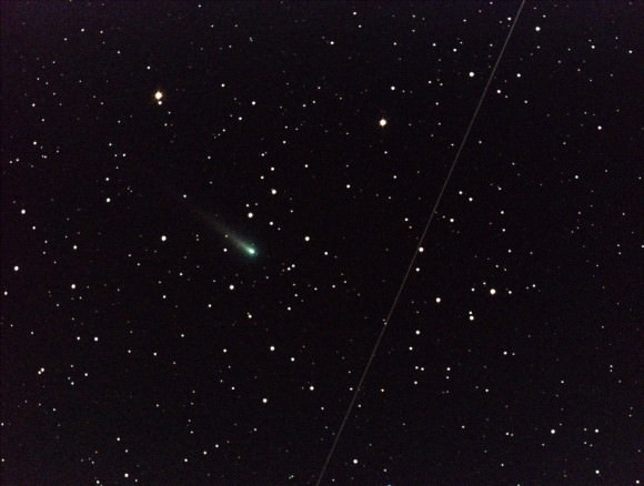
Color image of Comet ISON on October 27, 2013. Credit and copyright: Damian Peach.
Astrophotographers were out in full force this weekend to try and capture the bonanza of comets now visible in the early morning skies! You’ll need a good-sized telescope to see these comets for yourself, however, but with the Moon now waning means darker skies and better observing conditions. Above is an absolutely gorgeous image of Comet ISON taken by Damian Peach. See below for more images of not only Comet ISON, but also Comet Encke, Comet Lovejoy and Comet LINEAR — now in outburst.
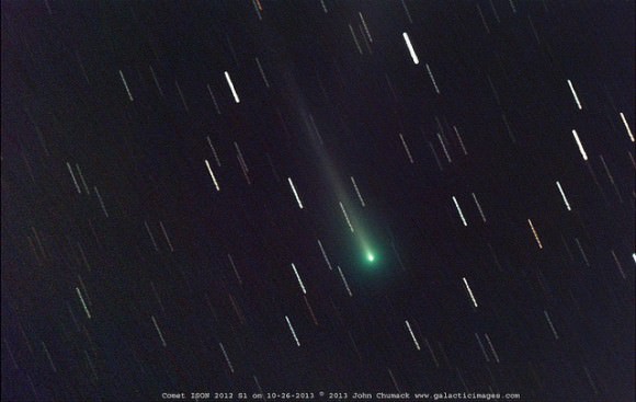
In fact, one of our “regular” contributors, John Chumack, captured all four comets in one morning, on Saturday October 26!
Four comets captured in one morning! Clockwise from top left: Comet ISON 2012 S1; Lovejoy C/2103 R1;, 2P ENCKE, Linear 2012 X1. Credit and copyright: John Chumack/Galactic Images.
Here’s what John said about his Comet ISON image: “The tail extends off the frame it is at least 20 arc minutes long now and the coma is still around 3-4 arc minutes in diameter. The comet is looking good at about 12th magnitude and continues to slowly brighten, just 30 more days to perihelion — closest point to the Sun. Hopefully it puts on a good show for all of December too!”
And Comet Linear 2012 X1 was at 14th magnitude, but now in outburst, John said, “it is over 100-fold brighter at 8th magnitude and expanding! It was low on the horizon at dawn, and tough to get. It just cleared the trees at 7:07am in bright dawn light! I managed a couple of quick shots before my CCD was flooded completely with light!”
Of Comet Lovejoy, John said, “I found it has developed a faint long tail…it is at least 12 arc minutes in length and the comet’s coma is now around 6 arc minutes in diameter. I already notified Terry Lovejoy in Australia and he was excited to hear his comet has developed a new tail!”
Here’s a timelapse video from John of Comet Lovejoy moving through the constellation of Canus Minor:
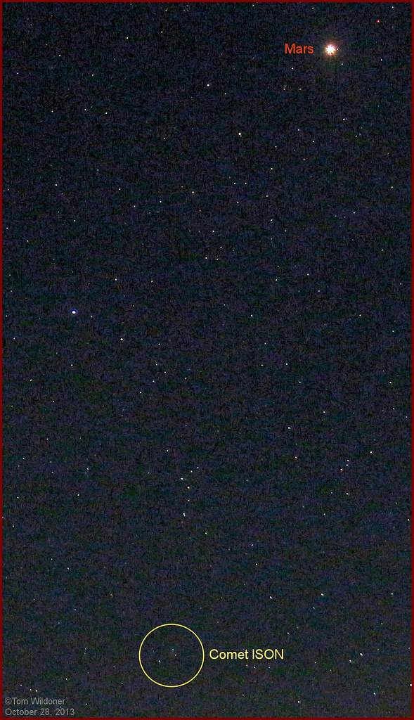
Here’s a view from a smaller telescope from Tom Wildoner, to give a better idea of what “most of us” would see with our humbler telescopes!
The view of Mars and Comet ISON on the morning of October 28, 2013. taken using a 75mm lens, 30 seconds at ISO 800. Look for the small blur inside the yellow circle. Credit and copyright: Tom Wildoner.Comet 2012 1X (LINEAR) on October 28, 2013 following its recent outburst. Obtained under bright twilight, low altitude and moonlight! Credit and copyright: Damian Peach.Comet ISON Nucleus on October 26, 2013 at 9:43 – 10:27 U.T. Taken with QHY8 CCD & Homemade 16″ Newtonian telescope. A total of 40 minutes of exposure (20 x 120 second exposures). Credit and copyright: John Chumack/Galactic Images.
Even NASA astronomers were out trying to take images of these comets. Here’s an image taken from NASA’s Marshall Spaceflight Center:
Comet ISON on October 25, 2013, taken with a 14 inch telescope at NASA’s Marshall Space Flight Center in Huntsville, Alabama. Credit: NASA/MSFC/Aaron Kingery
NASA explains the image:
In the early morning of Oct. 25 (6:45 a.m. EDT), NASA’s Marshall Space Flight Center in Huntsville, Ala., used a 14″ telescope to capture this image of Comet C/2012 S1 (ISON), which is brightening as it approaches the sun. The comet shines with a faint green color just to the left of center. The diagonal streak right of center was caused by the Italian SkyMed-2 satellite passing though the field of view. At magnitude 8.5, the comet is still too faint for the unaided eye or small binoculars, but it’s an easy target in a small telescope.
At this time of this image, ISON was located in the constellation of Leo the Lion, some 132 million miles from Earth and heading in toward the sun at 87,900 miles per hour.
Want to get your astrophoto featured on Universe Today? Join our Flickr group or send us your images by email (this means you’re giving us permission to post them). Please explain what’s in the picture, when you took it, the equipment you used, etc.
A partially eclipsed setting Sun as seen from Dallas, Texas on May 20th, 2012. This weekend's eclipse will offer U.S. East Coast residents a similar sunrise view. (Credit: Jason Major/Lights in the Dark).
It’s almost upon us. The final eclipse of 2013 occurs this coming weekend on Sunday, November 3rd. This will be the fifth eclipse overall, and the second solar eclipse of 2013. This will also be the only eclipse this year that features a glimpse of totality.
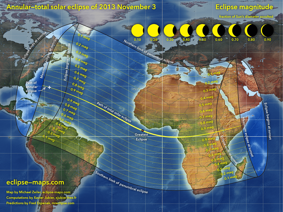
This eclipse is of the rare hybrid variety— that is, it will be an annular eclipse along the very first 15 seconds of its track before transitioning to a total as the Moon’s shadow sweeps just close enough to the Earth to cover the disk of the Sun along the remainder of its track.
An animation of the path of the November 3rd hybrid solar eclipse. (Credit: NASA/Goddard Space Flight Center).
How rare are hybrid solar eclipse? Of the 11,898 solar eclipses listed over a 5,000 year span from 1999 BC to 3000 AD in Fred Espenak’s Five Millennium Catalog of Solar Eclipses, only 569, or 4.8% are hybrids.
Who can see this eclipse?
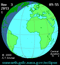
People from northern South America, across the U.S. Eastern Seaboard and up through the Canadian Maritimes will see a brief partial solar eclipse finishing up around 30 minutes after local sunrise. The brief annular “ring of fire” portion of the eclipse begins at sunrise just ~1,000 kilometres east of Jacksonville, Florida, as it races eastward across the Atlantic. See our timeline, below.
Eclipse prospects for the US East Coast. (Courtesy of Michael Zeiler @EclipseMaps)
Nearly all of Africa and the southern Mediterranean region including Spain will see partial phases of the eclipse, while greatest totality occurs just off of the coast of Liberia and heads for first landfall on the African continent over Wonga Wongue Reserve in Gabon. At this point, the duration of totality will already have shrunk back down to 1 minute and 7 seconds. The shadow of the Moon will then cross central Africa, headed for a short but brilliant sunset total eclipse over Uganda, Ethiopia, Kenya and Somalia.
The global path of this weekends eclipse-click to enlarge. (Credit: Michael Zeiler, @EclipseMaps).
This particular eclipse part of saros series 143 and is member 23 of the 72 eclipses in the cycle. The first eclipse in this saros occurred on March 7th, 1617, and the last one will occur on April 23rd, 2897.
Saros 143 also has a checkered place in eclipse history. The last eclipse in this series crossed south eastern Asia on October 24th, 1995.
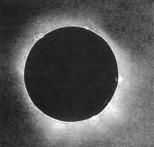
The first detailed picture of a solar eclipse was also taken of a saros 143 member on July 28, 1851. And one saros later, a total solar eclipse on August 7th, 1869 may have saved the butt of astronomer and explorer George Davidson while traversing the wilds of Alaska. And one more saros period later, Dmitri Mendeleev (he of the modern periodic table) observed the total solar eclipse of August 19th, 1887 from a balloon.
A daguerreotype image of the 1851 eclipse captured by Berkowski of the Royal Observatory in Königsberg, Prussia. (Public domain image).
We’ve compiled a brief worldwide timeline for the November 3rd hybrid eclipse. Keep in mind, the shift back off of Daylight Saving Time occurs on the same morning as the eclipse for North America, putting the U.S. East Coast once again back to -5 hours off of Universal Time (UT):
10:04 UT: The partial phases of the eclipse begin.
11:05:17 UT: annular phases of the eclipse begin.
11:05:36 UT: The eclipse transitions from an annular to a total along its track.
12:46: The point of greatest eclipse, occurring off of the SW coast of Liberia along the coast of Africa. The path will be 57 kilometres wide at this point with a maximum duration for totality at 1 minute & 40 seconds.
14:27 UT: The total phases of the eclipse end.
15:28 UT: Partial phases end.
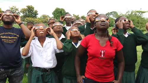
Remember that solar safety is paramount while observing an eclipse during all partial phases. This is especially critical, as millions of viewers along the U.S. East Coast are poised to catch the eclipse at sunrise over the Atlantic on Sunday. Use only glasses designed specifically for eclipse viewing or welder’s glass #14. One project headed by Astronomers Without Borders is also working to provide eclipse glasses to schools in Africa.
Students in Tanzania demonstrating proper eclipse viewing safety. (Credit: Astronomers Without Borders).
Projecting the Sun onto a wall or a piece of paper is also a safe method to observe the eclipse. Construction of a Sun Gun, a pinhole projector, or even using a spaghetti strainer or colander to project the partially eclipsed sun are all fun projects to try.
Shooting pictures of the rising eclipse is also possible using a DSLR. To capture the disk of the Sun plus an outline of the foreground, you’ll want to use a combination of low ISO 100 and a fast shutter speed (1/4000 or faster) and a zoom lens of at least 200mm or greater. Keep in mind, DO NOT look at the Sun through the camera’s view finder— simply set the focus to infinity and aim via projection. It’s worth practicing your technique a morning or two prior to the main event!
As the partial phase of the eclipse progresses, keep an eye out for “tiny crescents” that may litter the ground. These are caused by gaps in things such as leaves, latticework, etc that may act as natural “pinhole projectors”. Those lucky enough to stand in the path of totality may snare a look at shadow bands sweeping across the landscape as totality approaches, as well as catch a brief glimpse of Baily’s Beads and the pearly white corona of the Sun.
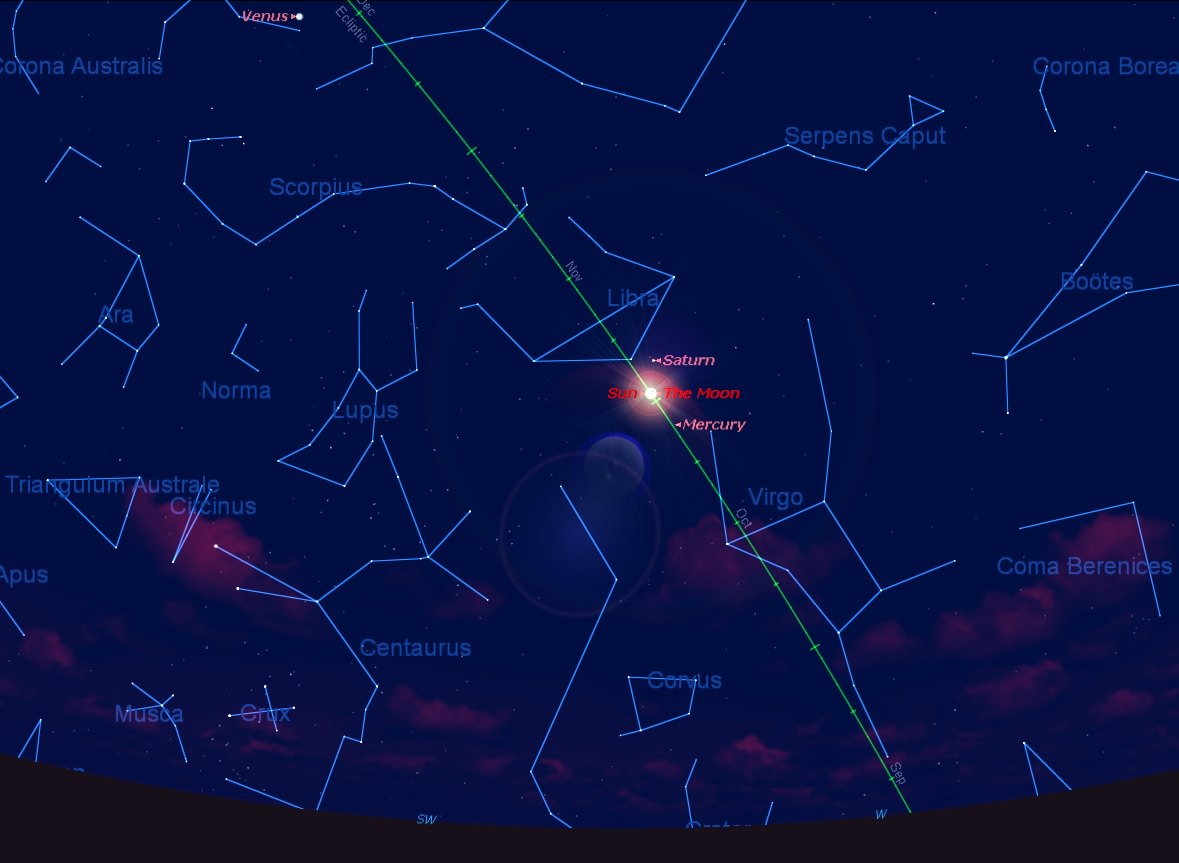
Totality will last less than a minute across most of central Africa, giving viewers a very hurried view before partial phases commence once more. Venus will be easily visible at magnitude -4.4 just 47 degrees east of the Sun. Unfortunately, prospects aren’t great for air or seaborne viewers in the mid-Atlantic to catch sight of comet ISON during the frenzied moments of totality, which will sit 50 degrees from the Sun between magnitude +7 & +8.
The sky over Gabon during mid-eclipse. (Created by the author using Starry Nite).
Weather prospects are an all-important consideration when planning for an eclipse. Jay Anderson maintains an outstanding site with projections tailor-made for each eclipse. For the U.S. East Coast, clear skies right down to the crucial eastern horizon will be key!
A recent surge in piracy off of the West Coast of Africa may also factor into travel considerations for eclipse chasers. You can actually monitor such activities on the high seas now in near real time. Perhaps one could take a page from Mark Twain’s A Connecticut Yankee in King Arthur’s Court, and impress any would-be-brigands with the glory of an impending solar eclipse…
Unfortunately, the International Space Station will have an orbit nearly perpendicular to the Earth-Moon-Sun syzygy, and won’t lend itself to any great prospects of a transit during the partial phases of the eclipse. ESA’s Proba-2 and JAXA’s Hinode will, however, see several partial eclipses from orbit:
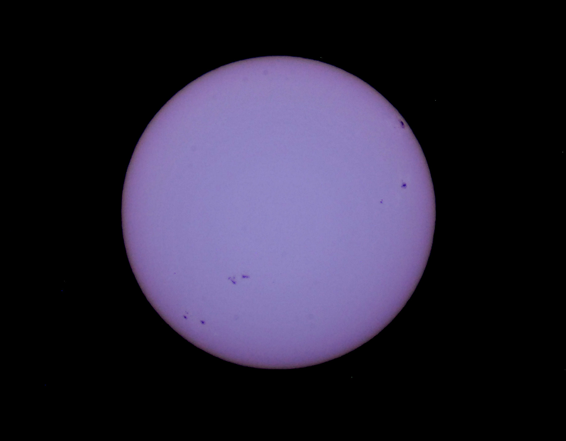
Sunspot activity has also been on the upswing as of late, making for a photogenic Sun heading into the partial phases of the eclipse. A well-placed, naked eye Coronal Mass Ejection on the solar limb also isn’t out of the question. Eclipse historian and expert Michael Zeiler notes that a CME last occurred during a total solar eclipse way back in 1860.
Sunspot activity as of October 28th… will it stay active until this weekend’s eclipse? (Photo by author).
Totality for this eclipse passes over some wild and largely wifi free areas; few plans to broadcast the eclipse live have surfaced thus far.
Slooh plans a broadcast, as did a proposed Indiegogo project whose current status is unclear. BRCK also plans to broadcast the eclipse live from the shores of Lake Turkana, Kenya. Got plans to webcast even the partial phases of the eclipse? Let us know!
And speaking of eclipse chasing, we plan on heading to the Florida Space Coast Sunday morning at o’dark thirty to nab the partial sunrise eclipse over the Atlantic.
And as always, the question posed immediately after totality is: when’s the next one? Well, the next annular eclipse graces Australia on April 29th, 2014. The U.S. will also see a partial solar eclipse on October 23rd next year… but totality will not touch the surface of our fair planet until a high Arctic eclipse on March 20th, 2015.
Good luck, clear skies, and safe journeys to all who are chasing after this one near and far, and don’t forget to post those pics to Universe Today’s Flickr page!
-See more of Michael Zeiler’s work at Eclipse Maps.
Although the Zodiac is best known for astrology nonsense, it has a purpose in astronomy too. The constellations of the Zodiac define the plane of the ecliptic: the region where the Sun, Moon and planets appear to travel through the sky. What are the constellations of the Zodiac, and how do astronomers use them as way points?
We record Astronomy Cast as a live Google+ Hangout on Air every Monday at 12:00 pm Pacific / 3:00 pm Eastern. You can watch here on Universe Today or from the Astronomy Cast Google+ page.
Screenshot from "Back To The Moon For Good", a dome show from the Google Lunar XPRIZE. The show covers the history of lunar exploration with an emphasis on the XPRIZE teams planning to make robotic journeys there themselves. Credit: Google Lunar XPRIZE
To drum up publicity for the Google Lunar XPRIZE missions, the organization has produced a “dome film” about exploring the moon through the past to the future — and is giving away the product for free to dozens of dome theaters and planetariums worldwide.
Among Back To the Moon For Good’s first appearances will be the National Science Center at Leicester, United Kingdom on Nov. 6, and a United States premiere is on its way shortly. A full list of participating venues so far is at this website. The target audience for the show (which is designed for a wraparound theater) is elementary and secondary school students.
“It was Mercury, Gemini and Apollo that took the us into space, and ultimately to the moon, and this was incredibly exciting and was responsible for lots of folks going into science and technology over the years,” said Bob Weiss, who is XPRIZE’s president and executive producer of the film, in a Universe Today interview.
“We would like to provide a 21st century version of that, but as a new kind of space mission, more interactive and participatory,” he added, saying that social media and Internet websites would be a couple of ways people at home can stay engaged in the mission or missions to the moon. (That definitely wasn’t possible generally when Apollo 11, the first moon mission, landed in 1969!)
Screenshot from “Back To The Moon For Good”, a Google Lunar XPRIZE dome movie. Credit: Google Lunar XPRIZE
The narrator of the show is Tim Allen, an actor best known for the Home Improvementseries of the 1990s. Allen, by the way, is a fan of space himself (says Weiss) and also appeared in a 1999 parody science fiction film called Galaxy Quest. Weiss said the desire was to find somebody who was family-friendly, well-known and enthusiastic about the project.
By the way, loyal fans of Home Improvement will recall that astronauts appeared on the “Tool Time” segment of the show on several occasions, usually after Hubble Space Telescope repair missions. (NASA astronaut Ken Bowersox appeared three times himself, in 1994, 1996 and 1998.)
In Season 3 show “Reality Bytes” in 1994, Tim Allen’s character asked STS-61 commander Dick Covey what the difference was between repairs in space and repairs on Earth. “It’s actually a lot like using tools here on Earth. Except there’s no gravity, so you don’t have to worry about dropping a tool on your foot,” Covey quipped.
If “Tool Time” was taking place now, we wonder if Allen would also be interviewing private companies working on robotic and human spaceflight. XPRIZE is still chugging along well, Weiss said, and added some of the teams have signed launch contracts to send their robots to the moon. (He declined to provide many details, citing confidentiality reasons.)
NASA astronaut Story Musgrave rides the Canadarm during the Hubble Space Telescope repair mission STS-61, in 1993. Credit: NASA
“We have folks who have launch contracts to go to the moon, and another serious sign is when there is real flight hardware that is being built and tested. I have seen myself some of this hardware, and there are teams that are really racing to beat each other,” he said.
“There are approximately 20 teams around the world competing to do this. It has been an interesting competition, watching some teams drop off and some devolve and recombine with each other.”
Teams have until Dec. 31, 2015 to send a robotic spacecraft to the moon, travel 500 meters (whether on, below or above the surface), and transmit two “mooncasts” for Earth. At least $40 million in “incentive-based prizes” are up for grabs. We’ve covered a few of the concepts on Universe Today before, such as one team seeking to send robots into moon caves, and a college group trying to put a rover on the surface.
Universe Today and Royal Observatory Greenwich are pleased to offer one free copy of Astronomy Photographer of the Year: Collection Two!
Universe Today Review by Dave Dehetre
Astronomy Photographer of the Year is a large format glossy book that covers the Royal Observatory, Greenwich’s annual astrophotography competition. It covers the competition years from 2009 to 2012 and subject categories: Earth and Space, Our Solar System, Deep Space, Young Astronomy Photographer, People and Space, Best Newcomer, and Robotic Scope. It also includes a brief how-to primer on astrophotography which, while fine, seemed perfunctory and tacked on.
The book is organized by years and then by category, with nice double page section breaks and clear detailed info alongside each image. However, within each year, the categories aren’t delineated, either through typographic means, such as headers or section breaks, or through any indication alongside the images themselves. Usually the category was obvious enough, but it was somewhat confusing at times. Each category contains images by the winner, runner-up, and sometimes one or more ‘highly-commended’ entrants. Some categories also had other images without any designation of why they were included. This could be a typographic omission of some sort, or it could be that they were just additional entrants worthy of inclusion.
I was happy to see the consistently high caliber of work that came out of the competition. There isn’t one image in the book that was less than outstanding. I’ve spent many a night far out in the countryside doing astrophotography as a hobby, and I’ve never come up with an image to compare.
I was also happy to see the competition segmented into subject areas as well as the more expected age/experience categories. This seems to acknowledge that there are different metrics and merit for the broad scope of styles/subjects in astrophotography.
One other point worth mentioning is that I found that many of the astrophotographers presented were people I was already familiar with, some from Flickr, some from Youtube, and some from periodicals like Sky at Night. I knew these people, and not because they produce great images, but because they are some of the people I learned astrophotography from. I think this points out one of the great underlying aspects of astrophotography: that it is collaborative in nature. And I find it heartening that the people who share the most, who help others and communicate, seem to be the ones who do the best work and are the most successful.
I’m of two minds about Astronomy Photographer of the Year though. On the one hand, it’s very well done, beautiful, and stunning. Really everything you could ask for in a book on this subject. But against it, in part it is trying to document something (astrophotography) that is bigger and richer than can be captured in a book.
While the images are flawlessly presented, they lack the backlit brilliance provided by a computer screen, and they aren’t zoomable to view fine details. Many astrophotography images are available on-line at resolutions equivalent to wall-size if they were printed out.
There is also the problem of completeness. While the book is cover-to-cover with great images, in large part it is singular images from outstanding photographers who have dozens or hundreds of stunning images on-line. I found myself flipping a few pages at a time, and then being overcome with a desire to go search out a photographer’s other images. This is perhaps an inevitable outcome of the fact that the competition was conducted on-line (via Flickr), so it’s hard to see it as a negative.
So it really is a fantastic book, I love having it on my shelf, and I often flip through at random and find myself getting inspired, but I don’t think I would have searched it out for that purpose, and I’m not sure who the target customer is supposed to be. It seems incomplete and cursory, especially in the technical details, for someone already involved with the hobby and yet it has a price tag and scope that seem inconsistent with an introductory level book. It would make a great addition to a library collection.
~
If you want to purchase a copy of Astronomy Photographer of the Year: Collection Two, it is available on Amazon.com.
Universe Today and Royal Observatory Greenwich are pleased to be able to offer one free copy of Astronomy Photographer of the Year: Collection Two to our readers. In order to be entered into the giveaway drawing, just put your email address into the box at the bottom of this post (where it says “Enter the Giveaway”) before Monday, November 4, 2013. If this is the first time you’re registering for a giveaway from Universe Today, you’ll receive a confirmation email immediately where you’ll need to click a link to be entered into the drawing. For those who have registered previously, you’ll receive an email later where you can enter this drawing.