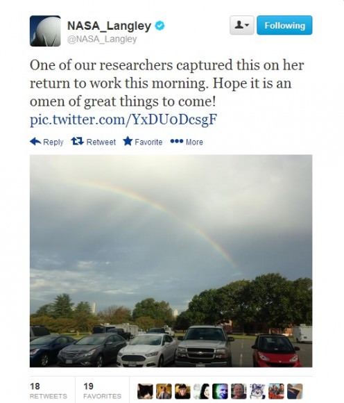
A message on the NASA 360 Twitter feed the day employees returned to work after a 16-day government shutdown in October 2013.
After 16 days off the job, most employees at NASA returned to work today (Oct. 17). The good news came after a late-night deal by U.S. politicians to reopen government activities until Jan. 15 and raise the debt limit — originally expected to expire today — until Feb. 7. Democrats and Republicans were battling over the implementation of a new health care law; more details on how the deal was reached are available in this New York Times article.
During the shutdown, only mission-essential functions at NASA were completed except at areas such as the Jet Propulsion Laboratory, which are run by contractors. Twitter, Facebook and social media updates went silent. Missions were run on a needs-only basis, and for a while it looked as though the upcoming MAVEN mission to Mars might be delayed (although it got an exception due to its role as a communications relay for NASA’s rovers.)
So you can imagine the happiness on social media when NASA employees returned to work.
Given the length of the shutdown, not all work can just start immediately. Experiments have been left unattended for more than two weeks. Equipment needs to be powered back on. Cancelled meetings and travel arrangements need to, as it is possible, be rebooked.
At NASA’s Marshall Space Flight Center, spokesperson Don Amatore asked employees to be mindful of safety precautions, according to All Alabama. He also stated that “liberal leave” is in effect for employees today and on Friday, meaning that employees are able to take time off without requesting it beforehand — as long as their supervisors know.
Several Twitter reports from NASA contractors on Thursday also indicated that they were unsure if they would be coming back to work on that day, or at some point in the near future. The agency, however, was reportedly sending automated telephone updates to employees and contractors advising them to check with their supervisors for information.
The Stratospheric Observatory for Infrared Astronomy, or SOFIA, 747SP basks in the light of a full moon shining over California’s Mojave Desert. Photo / Tom Tschida
The long-term effects of the shutdown are still coming to light. Certain NASA researchers who planned Antarctic work this year may lose their entire field season. Also, some researchers using NASA or government telescopes missed their “window” of telescope time. “SOFIA remains grounded as a testament to stupidity. Europa keeps her secrets,” wrote Mike Brown, a professor of planetary astronomy at the California Institute of Technology, on Twitter Oct. 13 about NASA’s Stratospheric Observatory for Infrared Astronomy.
Additionally, the S&P ratings agency noted that the U.S. economy lost $24 billion due to the shutdown, which is more than the initial $17.7 billion request for NASA’s budget in fiscal 2014. Given the agency is in the midst of budget negotiations and is worried about the viability of the commercial crew program, among other items, any long-term economic damage could hurt NASA for a while.
NASA and other government agencies also have only three months of relative stability until the government reaches another funding deadline. What do you think will happen next? Let us know in the comments.
The evidence that the Universe began with the Big Bang is very compelling. 13.8 billion years ago, the entire Universe was compressed into a microscopic singularity that grew exponentially into the vast cosmos we see today. But what does the future hold? How will the Universe end?
Astronomers have been pondering the ultimate fate of the Universe for thousands of years. In the last century, cosmologists considered three outcomes for the end of everything, and it all depended on the critical density of the Universe. If this critical density was high, then there was enough mutual gravity to slow and eventually halt the expansion. Billions of years in the future, it would then collapse in on itself again, perhaps creating another Big Bang. This is known as a closed Universe, and the final result is the Big Crunch.
If the critical density was low, then there wouldn’t be enough gravity to hold things together. Expansion would continue on forever and ever. Stars would die, galaxies would be spread apart, and everything would cool down to the background temperature of the Universe. This is an open Universe, and the end is known as the Big Freeze.
And if the critical density was just right, the Universe’s expansion goes on forever, but it’s always slowing down, reaching a dead stop in an infinite amount of time. This creates a Flat Universe… also a Big Freeze.
Fortunately, astronomers were able to measure the critical density of the Universe, using NASA’s WMAP spacecraft, and they discovered that the actual density of the Universe predicts a flat Universe. So that’s it, right? Of the three choices, the answer is #3.
Unfortunately, nature had other plans, and came up with a reality that nobody expected. In 1998, a team of astronomers were observing distant supernovae to get a sense of how fast the Universe is slowing down and they made an amazing discovery. Instead of decelerating, as predicted by the critical density of the Universe, the expansion of the Universe is actually speeding up.
Some mysterious force is pushing galaxies faster and faster away from each other, accelerating the expansion of the Universe. We now call this force “dark energy”, and for the time being, astronomers have no idea what it is. All we know is that it’s pushing the Universe apart. Distant galaxies are being accelerated away from us, and in trillions of years from now, they will cross the beyond the cosmic horizon and disappear from view. The evidence that we live in a vast Universe will disappear with them.
Galaxies spinning farther and farther away from each other
But there’s a further unsettling possibility about dark energy. Maybe the expansion pressure will increase, eventually overwhelming gravity on a local level. Galaxies will get torn apart, and then Solar Systems, and eventually atoms themselves will be shredded by the increasing dark energy – this idea is known as the Big Rip.
So how will the Universe end? The force of dark energy will continue to accelerate the expansion of the Universe until distant galaxies disappear. Galaxies will use up all the gas and dust for stars and go dark, perhaps becoming black holes. Those black holes will decay and maybe matter itself will decay into pure energy. The entire Universe will become a cold, quiet place, where single photons are stretched across light years of space.
Don’t worry, though, that won’t be for quadrillions of years from now.
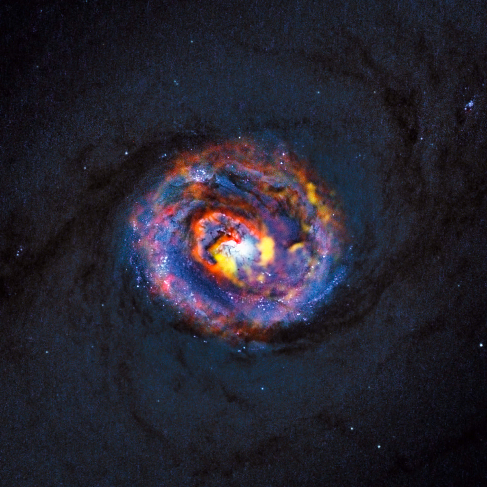
This detailed view shows the central parts of the nearby active galaxy NGC 1433. The dim blue background image, showing the central dust lanes of this galaxy, comes from the NASA/ESA Hubble Space Telescope. The coloured structures near the centre are from recent ALMA observations that have revealed a spiral shape, as well as an unexpected outflow, for the first time. Credit: ALMA (ESO/NAOJ/NRAO)/NASA/ESA/F. Combes
Did you ever wonder what it would be like to observe what happens to a galaxy near a black hole? For all of us who remember that wonderful Disney movie, it would be a remarkable – if not hypnotic – experience. Now, thanks to the powerful observational tools of the Atacama Large Millimeter/submillimeter Array (ALMA), two international astronomy teams have had the opportunity to study the jets of black holes near their galactic cores and see just how they impact their neighborhood. The researchers have captured the best view so far of a molecular gas cloud surrounding a nearby, quiescent black hole and were gifted with a surprise look at the base of a massive jet near a distant one.
These aren’t lightweights. The black holes the astronomers are studying weigh in a several billion solar masses and make their homes at the center of nearly all the galaxies in the Universe – including the Milky Way. Once upon a time, these enigmatic galactic phenomena were busy creatures. They absorbed huge amounts of matter from their surroundings, shining like bright beacons. These early black holes thrust small amounts of the matter they took in through highly powerful jets, but their current counterparts aren’t quite as active. While things may have changed a bit with time, the correlation of black hole jets and their surroundings still play a crucial role in how galaxies evolve. In the very latest of studies, both published today in the journal Astronomy & Astrophysics, astronomers employed ALMA to investigate black hole jets at very different scales: a nearby and relatively quiet black hole in the galaxy NGC 1433 and a very distant and active object called PKS 1830-211.
“ALMA has revealed a surprising spiral structure in the molecular gas close to the center of NGC 1433,” says Françoise Combes (Observatoire de Paris, France), who is the lead author of the first paper. “This explains how the material is flowing in to fuel the black hole. With the sharp new observations from ALMA, we have discovered a jet of material flowing away from the black hole, extending for only 150 light-years. This is the smallest such molecular outflow ever observed in an external galaxy.”
Need feedback? Well, that’s exactly what this process is called. “Feedback” may enlighten us to the relationship between black hole mass and the mass of the surrounding galactic bulge. The black hole consumes gas and becomes active, but then it creates jets which purge gas from its proximity. This halts star formation and controls the growth of the central bulge. In PKS 1830-211, Ivan Marti-Vidal (Chalmers University of Technology, Onsala Space Observatory, Onsala, Sweden) and his team witnessed a supermassive black hole with a jet, “but a much brighter and more active one in the early universe. It is unusual because its brilliant light passes a massive intervening galaxy on its way to Earth, and is split into two images by gravitational lensing.”
Are supermassive black holes messy eaters? You bet. There have been occasions when a supermassive black hole will unexpectedly consume a staggering amount of mass which, in turn, turbo-charges the power of the jets and lights up the radiation output to the very pinnacle of energy output. This energy is emitted as gamma rays, the shortest wavelength and highest energy form of electromagnetic radiation. And now ALMA has, by chance, caught one of these events as it happened in PKS 1830-211.
“The ALMA observation of this case of black hole indigestion has been completely serendipitous. We were observing PKS 1830-211 for another purpose, and then we spotted subtle changes of color and intensity among the images of the gravitational lens. A very careful look at this unexpected behavior led us to the conclusion that we were observing, just by a very lucky chance, right at the time when fresh new matter entered into the jet base of the black hole,” says Sebastien Muller, a co-author of the second paper.
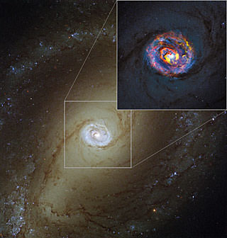
The main image, showing the nearby active galaxy NGC 1433, comes from the NASA/ESA Hubble Space Telescope. The coloured structures near the centre shown in the insert are from recent ALMA observations that have revealed a spiral shape, as well as an unexpected outflow, for the first time. Credit: ALMA (ESO/NAOJ/NRAO)/NASA/ESA/F. CombesAs with all astronomical observations, the key to discovery is confirmation. Did the ALMA findings show up on other telescopic observations? The answer is yes. Thanks to monitoring observations with NASA’s Fermi Gamma-ray Space Telescope, there was a definite gamma ray signature exactly where it should be. Whatever was responsible for the scaling up of radiation at ALMA’s long wavelengths was also responsible for making the light of the black hole jet flare impressively.
“This is the first time that such a clear connection between gamma rays and submillimeter radio waves has been established as coming from the real base of a black hole’s jet,” adds Sebastien Muller.
It isn’t the end of the story, however. It’s just the beginning. ALMA will continue to probe into the mysterious workings of supermassive black hole jets – both near and far. Combes and her investigative team are already observing close active galaxies with ALMA, and even a unique object cataloged as PKS 1830-211. The research will continue, and with it we may one day have answers to many questions.
“There is still a lot to be learned about how black holes can create these huge energetic jets of matter and radiation,” concludes Ivan Marti-Vidal. “But the new results, obtained even before ALMA was completed, show that it is a uniquely powerful tool for probing these jets — and the discoveries are just beginning!”
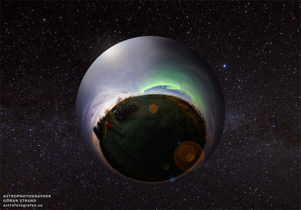
A unique panoramic image from of the aurora seen over Norway on October 14. Credit and copyright: Göran Strand.
How fun is this?! “Here’s a panoramic image from the aurora on October 14,” wrote Swedish astrophotographer Göran Strand. “I’ve made a small world trapped inside a bubble floating in space. And a lonely photographer is trying to capture the ongoing aurora with his camera.”
Synthetic view of the waxing Moon as viewed from Earth on 2013-10-15 17:00:00 UTC [NASA/GSFC/Arizona State University].
Take a look around the Moon… no, really, take a good look AROUND the Moon! This is a fantastic animation of our planetary partner in space made by the folks on the Lunar Reconnaissance Orbiter team at Arizona State University. Assembled from reflectance maps and digital terrain models created from data gathered by LRO’s wide-angle camera, this full 360-degree portrait of the Moon shows its surface as if it were receiving direct top-down sunlight on all points — a physical impossibility, yes, but it gives us a great view of pretty much everything (including the far side, which for obvious reasons most of us never get a good look at.)
In addition to shining a light on the lunar landscape (pun intended) the vast amounts of data used to create the view above can also be used to calculate the type of illumination that would be found on any point on the Moon, at any time, allowing for better targeted observation planning with LRO’s narrow-angle camera.
Read more about how this process was engineered here, and see a more recent result of these new capabilities below:
While the image above wouldn’t have been visible from anywhere on North America on October 15, 2013 at 2 p.m. EDT, it’s what would have been seen in the night sky above Mumbai — but no international calls to India were needed, as the view could simply be generated from the LRO WAC data and a ray-tracing algorithm that plots the angles of light and shadow across the lunar terrain. Voilà — it’s Insta-Moon*!
*Some assembly required.
Read more on the Arizona State University LROC site here (and to really blow your mind, watch the high-resolution version here.)
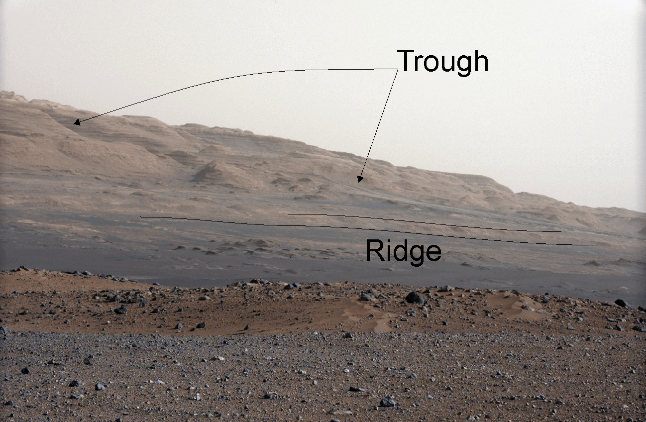
Curiosity is only eight miles (five kilometers) from a hematite-rich ridge at the bottom of Mount Sharp (Aeolis Mons). Credit: NASA/JPL-Caltech/MSSS
So Curiosity has been on Mars for an Earth year and is now, slowly, making its way over to that ginormous mountain — Mount Sharp, or Aeolis Mons — in the distance. The trek is expected to take at least until mid-2014, if not longer, because the rover will make pit stops at interesting science sites along the way. But far-thinking scientists are already thinking about what areas they would like to examine when it gets there.
One of those is an area that appears to have formed in water. There’s a low ridge on the bottom of the mountain that likely includes hematite, a mineral that other Mars rovers have found. (Remember the “blueberries” spotted a few years ago?) Hematite is an iron mineral that comes to be “in association with water”, a new study reports, and could point the way to the habitable conditions Curiosity is seeking.
The rub is scientists can’t say for sure how the hematite formed until the rover is practically right next to the ridge. There are plenty of pictures from orbit, but not high-resolution enough for the team to make definitive answers.
Colors map percentages of hematite in the surface materials in Meridiani Planum on Mars from 5 percent (aqua) to 25 percent (red). Opportunity landed within the black oval. MER scientists say the rocks there had once been drenched in water. Credit: NASA
“Two alternatives are likely: chemical precipitation within the rocks by underground water that became exposed to an oxidizing environment — or weathering by neutral to slightly acidic water,” wrote Arizona State University’s Red Planet Report. Either way, it shows the ridge likely hosted iron oxidation. Earth’s experience with this type of oxidation shows that it happens “almost exclusively” with microorganisms, but that’s not a guarantee on Mars.
Mars Reconnaissance Orbiter images show that the ridge is about 660 feet (200 meters) wide and four miles (6.5 kilometers) long, with strata or layers in the ridge appearing to be similar to those of layers in Mount Sharp.
While Curiosity is not designed to seek life, it can ferret out details of the environment. Just a few weeks ago, for example, it uncovered pebbles that likely formed in the presence of water. Other Mars missions have also found evidence of that liquid, with perhaps some of it once arising from the subsurface. Where the water came from, and why the environment of Mars changed so much in the last few billion years, are ongoing scientific questions.
Planets everywhere. So where are all the aliens? Credit: ESO/M. Kornmesser
A quiet milestone in modern astronomy may soon come to pass. As of today, The Extrasolar Planets Encyclopedia lists a current tally of 998 extrasolar planets across 759 planetary systems. And although various tabulations differ slightly, very soon we should be living in an era where over one thousand exoplanets are known.
The history of exoplanet discovery has paralleled the course of the modern age of astronomy. It’s strange to think that a generation has already grown up over the past two decades in a world where knowledge of extrasolar planets is a given. I remember hearing of the promise of such detections growing up in the 1970’s, as astronomers put the odds at detection of planets beyond our solar system in our lifetime at around 50%.
A “Periodic Table of Exoplanets” Credit: PHL @ UPR Arecibo.
Sure, there were plenty of false positives long before the first true discovery was made. 70 Ophiuchi was the site of many claims, starting with that of W.S. Jacob of the Madras Observatory way back in 1855. The high proper motion exhibited by Barnard’s Star at six light years distant was also highly scrutinized throughout the 20th century for claims of an unseen companion causing it to wobble. Ironically, Barnard’s Star still hasn’t made it into the pantheon of stars boasting planetary worlds.
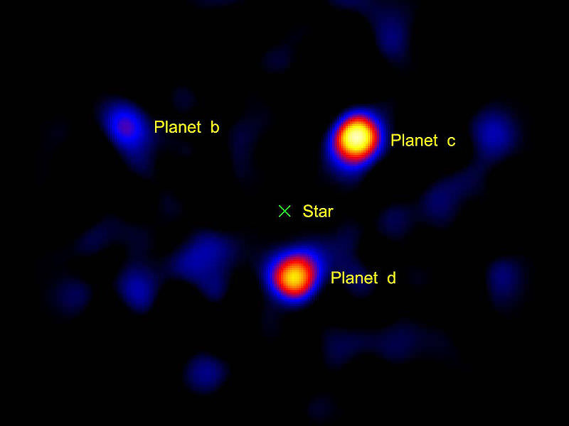
A portrait of the HR8799 planetary system as imaged by the Hale Telescope. (Credit: NASA/JPL-Caltech/Palomar Observatory).
But the first verified claim of an exoplanetary system came from a bizarre and unexpected source: a pulsar known as PSR B1257+12, which was discovered to host two worlds in 1992. This was followed by the first discovery of a world orbiting a main sequence star, 51 Pegasi in 1994. I still remember getting my hands on the latest issue of Astronomy magazine— we got our news, often months later, from actual paper magazines in those days —announcing “Planet Discovered!” on the cover.
Most methods and techniques used to discover exoplanets rely on either radial velocity or dips in the light output of a star from a transiting world. Both have their utility and drawbacks. Radial velocity looks for shifts in the star’s spectra as an unseen companion tugs it around a common center of mass. Though effective, it can only place a lower limit on the planet’s mass… and it’s biased towards worlds in short orbits. This is one reason that “hot Jupiters” have dominated the early exoplanet catalog: we hadn’t been looking for all that long.
Another method famously employed by surveys such as the Kepler space telescope is the transit detection method. This allows a much more refined estimate of a planet’s mass and orbit, assuming it transits the disk of its host star as seen from our Earthly vantage point in the first place, which most don’t.
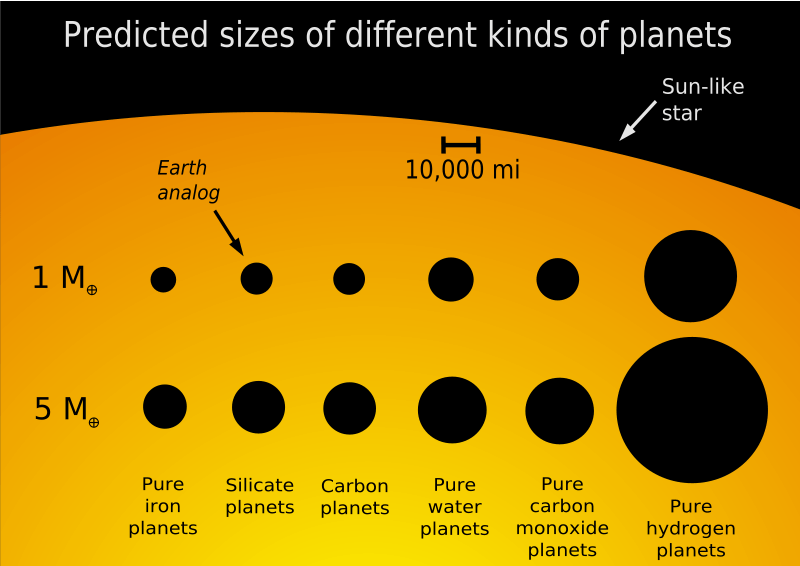
A size comparision of exoplanets versus composition. (Credit: Marc Kuchner/NASA/GSFC).
Direct detection via occulting the host star is also coming of age. One of the first exoplanets directly imaged was Fomalhaut b, which can be seen changing positions in its orbit from 2004 to 2006.
Gravitational microlensing has also bared planetary fruit, with surveys such as MOA (Microlensing Observations in Astrophysics) and OGLE (the Optical Gravitational Lensing Experiment) catching brief lensing events as an unseen body passes in front of a background star. Distant free-ranging rogue planets can only be detected via this method.
More exotic techniques also exist, such as relativistic beaming (sounding like something out of Star Trek). Other methods include searches for tiny light variations as an illuminated planet orbits its host star, deformities caused by ellipsoidal variations as massive planets orbit a star, and infrared detections of circumstellar disks. We’re always amazed at the wealth of data that can be teased out of a few dim photons of light.
A scatter plot of exoplanet discoveries as of 2010 displaying mass versus semi-major axis. Select exoplanets are labeled. A majority were detected via radial velocity (blue) and the transiting method (green). The remainder were detected by other methods (click here for a full description). Graph in the Public Domain.
Universe Today has grown up with exoplanet science, from reporting on the hottest, fastest, and other notable “firsts”. A bizarre menagerie of worlds are now known, many of which defy the imagination of science fiction writers of yore. Want a world made of diamond, or one where it rains glass? There’s now an “exoplanet for that”.
Exoplanet news has almost gone from the incredible to the routine, as Tatooine-like worlds orbiting binary stars and systems with worlds in bizarre resonances are announced with increasing frequency.
Exoplanet surveys also have a capacity to peg down that key fp factor in the famous Drake equation, which asks us “what fraction of stars have planets”. It’s been long suspected that stars with planets are the rule rather than the exception, and we’re just now getting hard data to back that assertion up.
Missions, such as NASA’s Kepler space telescope and CNES/ESA CoRoT space telescope have swollen the ranks of extrasolar worlds. Kepler recently ended its career staring off in the direction of the constellations Cygnus, Hercules and Lyra and still has over 3,200 detections awaiting confirmation.
Exoplanet discoveries by year as of October 2013, color coded by method. Blue=radial velocity, Green=transiting, Yellow=timing, Red=direct imaging, Orange=microlensing
But is a given world Earthlike, or just Earth-sized? That’s the Holy Grail of modern exoplanet detection: an Earth-sized world orbiting in a star’s habitable zone. We’re cautious every time the latest “Earth-twin” makes its way into the headlines. From the perspective of an intergalactic astronomer, Venus in our own solar system might appear to fit the bill, though I wouldn’t bank the construction of an interstellar ark on it and head there just yet.
Exoplanet science has definitely come of age, allowing us to finally begin characterization of solar systems and give us some insight into solar system formation.
But perhaps what will be the most enduring legacy is what the discovery of extrasolar planets tells us about ourselves. How common (or rare) is the Earth? How typical is the story of our solar system? If the “first 1,000” are any indication, we strongly suspect that terrestrial planets come in enough distinct varieties or ”flavors” to make Baskin Robbins envious.
And the future of exoplanet science looks bright indeed. One proposed mission, known as the Fast INfrared Exoplanet Spectroscopy Survey Explorer, or FINESSE, would target exoplanet atmospheres, if given the go ahead for a 2017 launch. Another proposal, known as the Wide Field Infrared Survey Telescope, or WFIRST, would search for microlensing events starting in 2023. A mission that scientists would love to fly that always seems to be shelved is known as the Terrestrial Planet Finder.
But the exoplanet hunting mission that’s closest to launch is the Transiting Exoplanet Survey Satellite, or TESS. Unlike Kepler, which stares at a single patch of sky, TESS will be an all-sky survey looking at a half million stars.
We’re also just approaching an era where spectroscopy may allow us to detect exomoons and the chemistry taking place on these far off exoworlds. An example of an exciting discovery would be the detection of a chemical such as chlorophyll, a chemical that we know on Earth only exists as the result of life. But what a tantalizing discovery a blip on a graph would be, when what we humans really want to see is the vista of those far-flung alien forests!
Such is the exciting era we live in. Congratulations, humanity, on detecting 1,000 exoplanets… here’s to a thousand more!
Felix Baumgartner celebrates after successfully completing his record-breaking jump. Credit: Red Bull Stratos.
A year ago, BASE jumper Felix Baumgartner dove out of a balloon-borne capsule in the stratosphere (not space), 39 kilometers (24 miles) up. It was what I called “part science experiment, part publicity stunt, part life-long ambition,” with Baumgartner attempting to break the speed of sound with his body in a record-setting freefall. He accomplished just that, although many have questioned the usefulness of this “stunt” (read Amy Shira Teitel’s great piece from last year.)
But, in some sense, you gotta admire Baumgartner’s courage.
Red Bull has now released a new full 9.5-minute video of the entire dive, showing several views, including what Baumgartner saw during the dive, along with real-time readouts of his altitude, airspeed, G-force load, heart rate and other data. It’s interesting to watch how he got himself out of the incredible spin he was in, and fun to see how he opened up his visor before hitting the ground.
Here’s what Baumgartner said about the spin in the post-jump press conference last year:
“It started out really good because my exit was perfect, I did exactly what I was supposed to do… It looked like for a second I was going to tumble two more times and then get it under control, but for some reason that spin became so violent over all axis and it was hard to know how to get out of it, because, if you are trapped in a pressurized suit – normally as a skydiver you can feel the air and get direct feedback from the air — but here you are trapped in a suit that is pressurized at 3.5 PSI so you don’t know how to feel the air. It is like swimming without touching the water. And it’s hard because every when time it turns you around you have to figure out what to do. So I was sticking my arm out and it became worse and then I stuck arm out the other side and it became less, so I was fighting all the way down to regain control because I wanted to break the speed of sound. And I hit it. I don’t know how many seconds, but I could feel air was building up and then I hit it.”
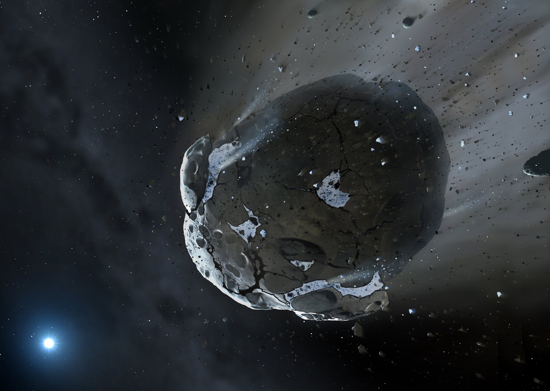
Artist's impression of a rocky and water-rich asteroid being torn apart by the strong gravity of the white dwarf star GD 61. Credit: Mark A. Garlick, space-art.co.uk, University of Warwick and University of Cambridge
Remains of a water-filled asteroid are circling a dying white dwarf star, right now, about 150 light-years from us. The new find is the first demonstration of water and a rocky surface in a spot beyond the solar system, researchers say.
The discovery is exciting to the astronomical team because, according to them, it’s likely that water on Earth came from asteroids, comets and other small bodies in the solar system. Finding a watery rocky body demonstrates that this theory has legs, they said. (There are, however, multiple explanations for water on Earth.)
“The finding of water in a large asteroid means the building blocks of habitable planets existed – and maybe still exist – in the GD 61 system, and likely also around substantial number of similar parent stars,” stated lead author Jay Farihi, from Cambridge’s Institute of Astronomy.
Earth’s oxygen and water as detected by Venus Express (ESA)
“These water-rich building blocks, and the terrestrial planets they build, may in fact be common – a system cannot create things as big as asteroids and avoid building planets, and GD 61 had the ingredients to deliver lots of water to their surfaces. Our results demonstrate that there was definitely potential for habitable planets in this exoplanetary system.”
More intriguing, however, is researchers found this evidence in a star system that is near the end of its life. So the team is framing this as a “look into our future”, when the Sun evolves into a white dwarf .
The water likely came from a “minor planet” that was at least 56 miles (90 kilometers) in diameter. Its debris was pulled into the atmosphere of the star, which was then examined by spectroscopy. This study revealed the ingredients of rocks inside the star, including magnesium, silicon and iron. Researchers then compared these elements to how abundant oxygen was, and found that there was in fact more oxygen than expected.
White Dwarf Star
“This oxygen excess can be carried by either water or carbon, and in this star there is virtually no carbon – indicating there must have been substantial water,” stated co-author Boris Gänsicke, from the University of Warwick.
“This also rules out comets, which are rich in both water and carbon compounds, so we knew we were looking at a rocky asteroid with substantial water content – perhaps in the form of subsurface ice – like the asteroids we know in our solar system such as Ceres.”
The measurements were obtained in ultraviolet with the Hubble Space Telescope’s cosmic origins spectrograph. What’s more, the researchers suspect there are giant exoplanets in the area because it would take a huge push to move this object from the asteroid belt — a push that most likely came from big planet.
“This supports the idea that the star originally had a full complement of terrestrial planets, and probably gas giant planets, orbiting it – a complex system similar to our own,” Farihi added.
Have you ever wondered what it’s like to visit one of the big research observatories, like Keck, Gemini, or the European Southern Observatory? What’s it like to use gear that powerful? What’s the facility like? What precautions do you need to take when observing at such a high altitude?
We record Astronomy Cast as a live Google+ Hangout on Air every Monday at 12:00 pm Pacific / 3:00 pm Eastern. You can watch here on Universe Today or from the Astronomy Cast Google+ page.