New topography map of Antarctica by the British Antarctic Survey's Bedmap2 (NASA/GSFC)
Although it sits isolated at the “bottom of the world” Antarctica is one of the most influential continents on Earth, affecting weather, climate, and ocean current patterns over the entire planet. But Antarctica is also one of the most enigmatic landmasses too, incredibly remote, extremely harsh, and covered by a layer of ice over 2 km thick. And as Earth’s global temperature continues to climb steadily higher, the future of ice in Antarctica — a continent half again as large as the contiguous United States — is a big concern for scientists… but in order to know exactly how its ice will behave to changing conditions, they need to know what’s under it.
This is where the British Antarctic Survey — using data gathered by NASA’s ICESat and Operation IceBridge missions — comes in, giving us a better view of what lies beneath the southern continent’s frozen veil.
A new dataset called Bedmap2 gives a clearer picture of Antarctica from the ice surface down to the bedrock below. Bedmap2 is a significant improvement on the previous collection of Antarctic data — known as Bedmap — that was produced more than 10 years ago. The product was a result of work led by the British Antarctic Survey, where researchers compiled decades worth of geophysical measurements, such as surface elevation measurements from NASA’s Ice, Cloud and Land Elevation Satellite (ICESat) and ice thickness data collected by Operation IceBridge.
Bedmap2, like the original Bedmap, is a collection of three datasets—surface elevation, ice thickness and bedrock topography. Both Bedmap and Bedmap2 are laid out as grids covering the entire continent, but with a tighter grid spacing Bedmap2 includes many surface and sub-ice features too small to be seen in the previous dataset. Additionally, the extensive use of GPS data in more recent surveys improves the precision of the new dataset.
Improvements in resolution, coverage and precision will lead to more accurate calculations of ice volume and potential contribution to sea level rise.
Ice sheet researchers use computer models to simulate how ice sheets will respond to changes in ocean and air temperatures. An advantage of these simulations is that they allow testing of many different climate scenarios, but the models are limited by how accurate the data on ice volume and sub-ice terrain are.
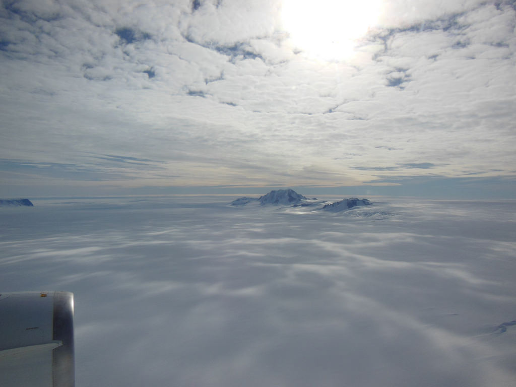
Only the tips of many of Antarctica’s mountains are visible above thousands of feet of ice. (Oct. 2012 IceBridge photo. Credit: NASA / Christy Hansen)
“In order to accurately simulate the dynamic response of ice sheets to changing environmental conditions, such as temperature and snow accumulation, we need to know the shape and structure of the bedrock below the ice sheets in great detail,” said Michael Studinger, IceBridge project scientist at NASA Goddard.
Knowing what the bedrock looks like is important for ice sheet modeling because features in the bed control the ice’s shape and affect how it moves. Ice will flow faster on a downhill slope, while an uphill slope or bumpy terrain can slow an ice sheet down or even hold it in place temporarily. “The shape of the bed is the most important unknown, and affect how ice can flow,” said Nowicki. “You can influence how honey spreads on your plate, by simply varying how you hold your plate.” The vastly improved bedrock data included in Bedmap2 should provide the level of detail needed for models to be realistic.
Bedmap2 data of Antarctica’s bedrock. Verical elevation has been exaggerated by 17x. (NASA/GSFC)
“It will be an important resource for the next generation of ice sheet modelers, physical oceanographers and structural geologists,” said Peter Fretwell, BAS scientist and lead author.
The BAS’ work was published recently in the journal The Cryosphere. Read more on the original release by George Hale here.
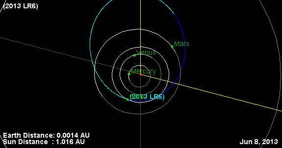
Orbit diagram of Asteroid 2013 LR6. Credit: JPL Small Body Database.
A truck-sized asteroid just discovered yesterday (Thursday, June 6) will give Earth a relatively close shave later today/early tomorrow, depending on your time zone. Asteroid 2013 LR6 is somewhere between 5- 16 meters (16 to 54 feet) in diameter and will be flying by at only about 111,000 kilometers (69,000 mi, 0.29x Lunar Distances) from Earth at 4:43UTC/12:43AM EDT on June 8, 2013.
This is similar in size to the space rock that exploded over Russia back in February of this year. The Russian asteroid was about 15 meters (50 feet) in diameter before it exploded in an airburst event about 20-25 km (12-15 miles) above Earth’s surface.
Find out how you can watch the flyby live online, below.
This flyby is not at close as February’s 2012 DA14 flyby, but it indeed is quite close by Solar System standards. It will be speeding by 9.8 km a second (6.14 mi/s). The asteroid was first spotted by the Catalina Sky Survey and now several other observatories have made follow-up observations to verify and help determine its size and orbit.
According to the Minor Planet Center’s Twitter feed, 2013 LR6 is the 167th minor planetary object discovered so far in the month of June 2013! That is incredible, and as astronomer Nick Howes said via Twitter, “That number should give people a good heads up as to why searching is important.”
According to our David Dickinson, 2013 LR6 will be plunging thru the constellation Vela at closest approach tonight, but it will be a faint one, as it won’t break +13 magnitude.
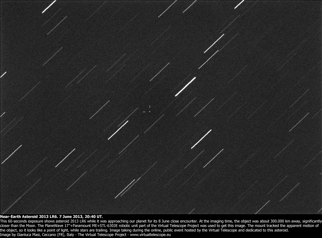
Since this discovery is so new, Gianluca Masi and the Virtual Telescope Project in Italy has put together a last-minute opportunity to watch the flyby live, online via their telescopes.
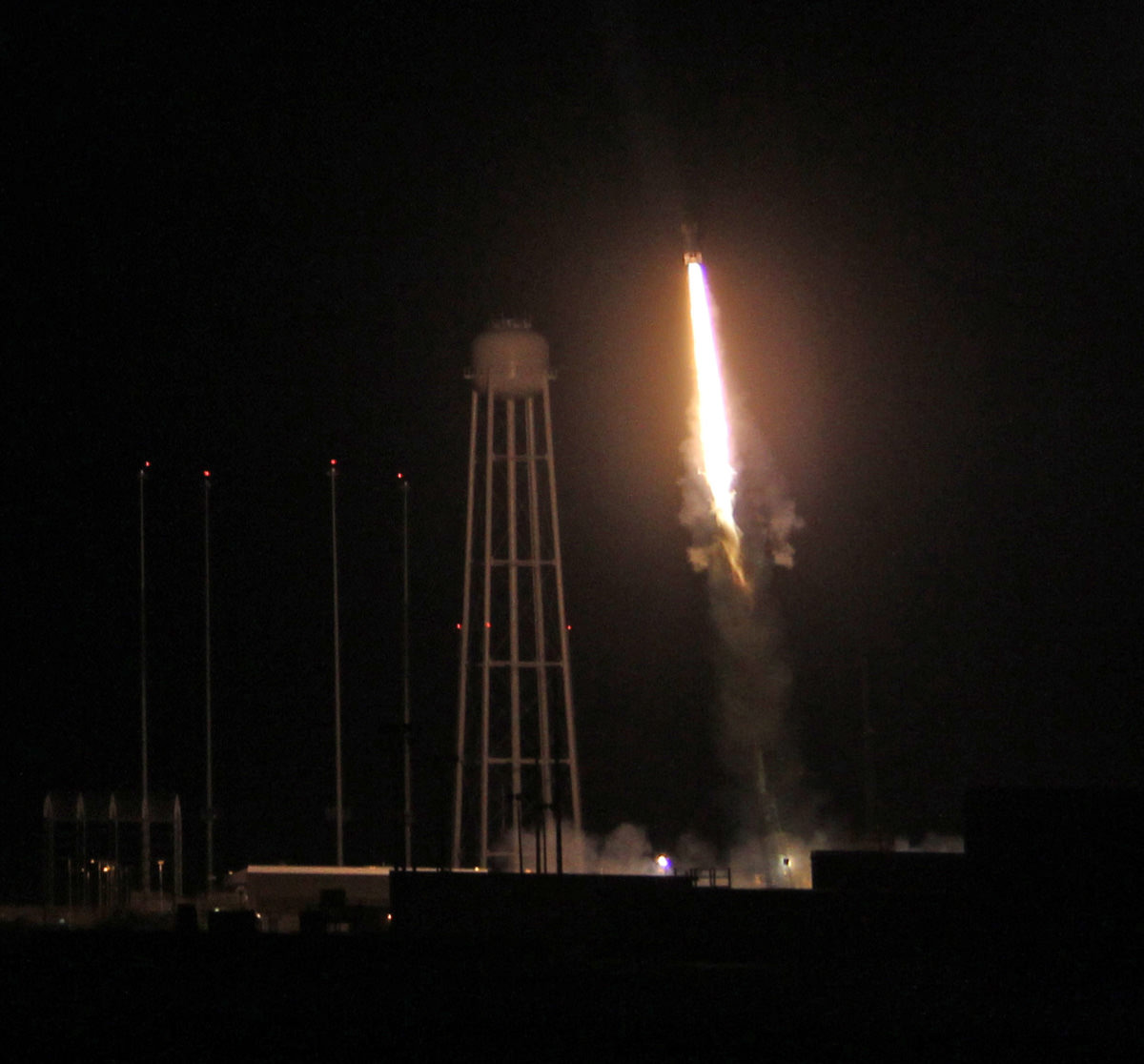
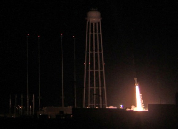
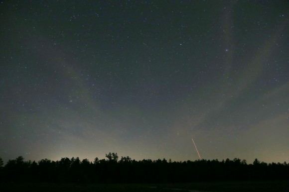
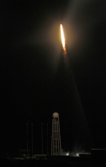
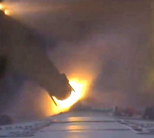
Night time blast off of 4 stage NASA Black Brant XII suborbital rocket at 11:05 p.m. EDT on June 5, 2013 from the NASA Wallops Flight Facility carrying the CIBER astronomy payload to study when the first stars and galaxies formed in the universe. The Black Brant soars above huge water tower at adjacent Antares rocket launch pad at NASA Wallops. Credit: Ken Kremer- kenkremer.com
Night time blast off of 4 stage NASA Black Brant XII suborbital rocket at 11:05 p.m. EDT on June 5, 2013 from the NASA Wallops Flight Facility carrying the CIBER astronomy payload to study when the first stars and galaxies formed in the universe. The Black Brant soars above huge water tower at adjacent Antares rocket launch pad at NASA Wallops. Credit: Ken Kremer- kenkremer.com Updated with more photos[/caption]
WALLOPS ISLAND, VA – The spectacular night time launch of a powerful Black Brant XII suborbital rocket from NASA’s launch range at the Wallops Flight Facility on Virginia’s Eastern Shore at 11:05 p.m. June 5 turned darkness into day as the rocket swiftly streaked skyward with the Cosmic Infrared Background ExpeRiment (CIBER) on a NASA mission to shine a bright beacon for science on star and galaxy formation in the early Universe.
A very loud explosive boom shook the local launch area at ignition that was also heard by local residents and tourists at distances over 10 miles away, gleeful spectators told me.
“The data looks good so far,” Jamie Bock, CIBER principal investigator from the California Institute of Technology, told Universe Today in an exclusive post-launch interview inside Mission Control at NASA Wallops. “I’m very happy.”
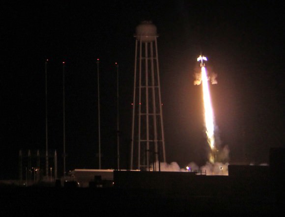
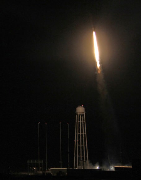
Ignition of NASA Black Brant XII suborbital rocket following night time launch at 11:05 p.m. EDT on June 5, 2013 from the NASA Wallops Flight Facility at the eastern Virginia shoreline. The launch pad sits in front of the Antares rocket Launch Complex 0A dominated by the huge water tower. The rocket carried the CIBER astronomy payload to an altitude of approximately 358 miles above the Atlantic Ocean to study when the first stars and galaxies formed in the universe and how brightly they burned their nuclear fuel. Credit: Ken Kremer- kenkremer.com
The four stage Black Brant XII is the most powerful sounding rocket in America’s arsenal for scientific research.
“I’m absolutely thrilled with this launch and this is very important for Wallops,” William Wrobel, Director of NASA Wallops Flight Facility, told me in an exclusive interview moments after liftoff.
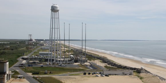
Wallops is rapidly ramping up launch activities this year with two types of powerful new medium class rockets – Antares and Minotaur V- that can loft heavy payloads to the International Space Station (ISS) and to interplanetary space from the newly built pad 0A and the upgraded, adjacent launch pad 0B.
“We have launched over 16,000 sounding rockets.”
“Soon we will be launching our first spacecraft to the moon, NASA’s LADEE orbiter. And we just launched the Antares test flight on April 21.”
I was delighted to witness the magnificent launch from less than half a mile away with a big group of cheering Wallops employees and Wallops Center Director Wrobel. See my launch photos and time lapse shot herein.
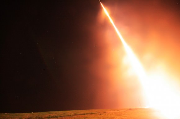
Everyone could hear piercing explosions as each stage of the Black Brant rocket ignited as it soared to the heavens to an altitude of some 358 miles above the Atlantic Ocean.
Seconds after liftoff we could see what looked like a rain of sparkling fireworks showing downward towards the launch pad. It was a fabulous shower of aluminum slag and spent ammonium perchlorate rocket fuel.
A powerful NASA Black Brant XII suborbital rocket streaks spectacularly into the night sky following its launch at 11:05 p.m. EDT on June 5, 2013 from the NASA Wallops Flight Facility at the eastern Virginia shoreline. The launch pad sits in front of the Antares rocket Launch Complex 0A dominated by the huge water tower. The rocket carried the Cosmic Infrared Background ExpeRiment (CIBER) to an altitude of approximately 358 miles above the Atlantic Ocean to study when the first stars and galaxies formed in the universe and how brightly they burned their nuclear fuel. Side firing thrusters have ignited to impart stabilizing spin as rocket ascends above launch rail. Credit: Ken Kremer- kenkremer.com
The awesome launch took place on a perfectly clear night drenched with brightly shining stars as the Atlantic Ocean waves relentlessly pounded the shore just a few hundred feet away.
The rocket zoomed past the prominent constellation Scorpius above the Atlantic Ocean.
In fact we were so close that we could hear the spent first stage as it was plummeting from the sky and smashed into the ocean, perhaps 10 miles away.
After completing its spectral collection to determine when did the first stars and galaxies form and how brightly did they shine burning their nuclear fuel, the CIBER payload splashed down in the Atlantic Ocean and was not recovered.
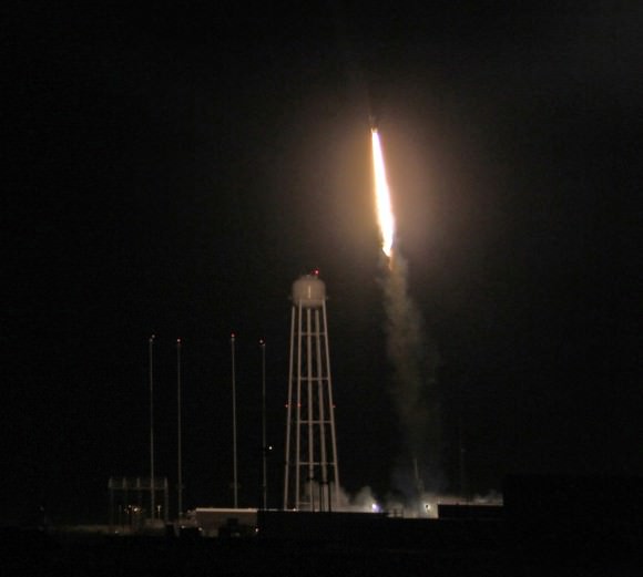
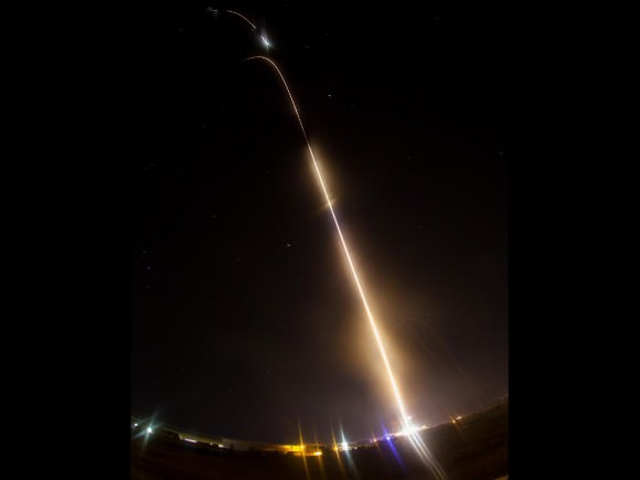
Time lapse view of night launch of NASA Black Brant XII suborbital rocket zooming past constellation Scorpius (left) at 11:05 p.m. EDT above Atlantic Ocean on June 5, 2013 from the NASA Wallops Flight Facility carrying the CIBER astronomy payload. Credit: Ken Kremer- kenkremer.comNight time launch of NASA Black Brant XII suborbital rocket at 11:05 p.m. EDT on June 5, 2013 from the NASA Wallops Flight Facility carrying the CIBER astronomy payload. Credit: Ken Kremer- kenkremer.com
NASA said the launch was seen from as far away as central New Jersey, southwestern Pennsylvania and northeastern North Carolina.
One of my astronomy friends Joe Stieber, did see the launch from about 135 miles away in central New Jersey and captured beautiful time lapse shots (see below).
Time lapse view of June 5 launch of Blank Brant XII sounding rocket from Wallops Island as seen from Carranza Field in Wharton State Forest, NJ (about 135 miles north from Wallops). Scorpius is above the trees at the far left. Credit: Joe Stieber- sjastro.com
Everything with the rocket and payload went exactly as planned.
“This was our fourth and last flight of the CIBER payload,” Bock told me. “We are still analyzing data from the last 2 flights.”
“CIBER first flew in 2009 atop smaller sounding rockets launched from White Sands Missile Range, N.M. and was recovered.”
“On this flight we wanted to send the experiment higher than ever before to collect more measurements for a longer period of time to help determine the brightness of the early Universe.”
CIBER is instrumented with 2 cameras and 2 spectrometers.
“The payload had to be cooled to 84 Kelvin with liquid nitrogen before launch in order for us to make the measurements,” Bock told me.
“The launch was delayed a day from June 4 because of difficulty both in cooling the payload to the required temperature and in keeping the temperature fluctuations to less than 100 microkelvins,” Bock explained
The CIBER experiment involves scientists and funding from the US and NASA, Japan and South Korea.
Bock is already thinking about the next logical steps with a space based science satellite.
Space.com has now featured an album of my CIBER launch photos – here
Night launch of NASA Black Brant XII suborbital rocket at 11:05 p.m. EDT on June 5, 2013 from NASA Wallops Flight Facility, VA carrying CIBER astronomy payload. Credit: Ken Kremer
And don’t forget to “Send Your Name to Mars” aboard NASA’s MAVEN orbiter- details here. Deadline: July 1, 2013
June 23: “Send your Name to Mars on MAVEN” and “CIBER Astro Sat, LADEE Lunar & Antares Rocket Launches from Virginia”; Rodeway Inn, Chincoteague, VA, 8 PM
Aerial view of NASA Wallops launch site on Virginia shore shows launch pads for both suborbital and orbital rockets. CIBER’s Black Brant XII rocket blasted off just behind the Pad 0A water tower. This photo was snapped from on top of Pad 0B that will soon launch NASA‘s LADEE orbiter to the Moon. Credit: Ken Kremer- kenkremer.comNASA’s CIBER experiment seeks clues to the formation of the first stars and galaxies. CIBER blasted off on June 5 from the NASA Wallops Flight Facility, Virginia. It will study the total sky brightness, to probe the component from first stars and galaxies using spectral signatures, and searches for the distinctive spatial pattern seen in this image, produced by large-scale structures from dark matter. This shows a numerical simulation of the density of matter when the universe was one billion years old. Galaxies formation follows the gravitational wells produced by dark matter, where hydrogen gas coalesces, and the first stars ignite. Credit: Volker Springel/Virgo Consortium.NASA Time lapse view shows multiple stages firing during night launch of NASA Black Brant XII suborbital rocket at 11:05 p.m. EDT above Atlantic Ocean on June 5, 2013 from the NASA Wallops Flight Facility carrying the CIBER astronomy payload. Credit: NASA/Jamie AdkinsNASA Black Brant XII suborbital rocket streaks skyward after blastoff at 11:05 p.m. EDT on June 5, 2013 from NASA Wallops Flight Facility, VA carrying CIBER astronomy payload. Credit: Ken Kremer
You might just see a few meteors from the combined Arietids and Zeta Perseid showers that peak Friday and Saturday mornings. This map shows the sky facing northeast at dawn for the mid-section of the U.S. Created with Stellarium
I’ve never seen an Arietid meteor and chances are you haven’t either. Peaking on June 7-8, the Arietid (AIR-ee-uh-tid) meteor shower is one of the strongest of the year with a maximum rate of 50-80 per hour. But there’s a rub. The shower radiant, the point in the sky from which the meteors appear to radiate, is near the sun and best seen during daylight hours. When was the last time you saw meteors in daylight?
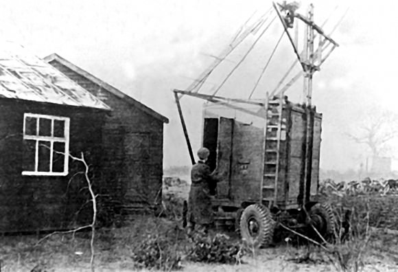
Early scientific exploration of the sky in radio waves at Jodrell Bank Observatory in 1945. Credit: Jodrell Bank, University of Manchester
If you’re wondering how anyone could discover a meteor shower when the sun is out, it’s impossible unless your eyes can see radio waves. The Arietids were first “seen” in 1947 by operators of radio equipment at Jodrell Bank Observatory in England. Meteors leave trails of ionized gases when they rip through our upper atmosphere at tens of thousands of miles per hour and briefly make ideal reflectors of radio waves.
You can even hear them yourself by tuning to a “blank” spot between stations on an FM radio and listening for sudden bursts of talk or music when the meteor trail boosts a neighboring station into audibility. Click HERE for simple instructions if you’d like to give it a try.
The Arietids are joined by a second daytime shower at the same time by the Zeta Perseids, a smaller shower, to guarantee a couple busy days of meteor-listening — and potential meteor-watching — on and around June 7-8. Most meteor showers are tied to a particular comet, since they’re swarms of dusty detritus left behind in a comet’s wake as it travels ’round the sun. When Earth intersects the stream, tiny comet bits slam into the atmosphere, heat up to 3,000 F or more and self-immolate in glowing streaks we call meteors. Occasionally a shower’s parent can be an asteroid as in the case of the January Quadrantid meteor shower. It’s suspected that the asteroid 2003 EH1 may be a extinct comet.
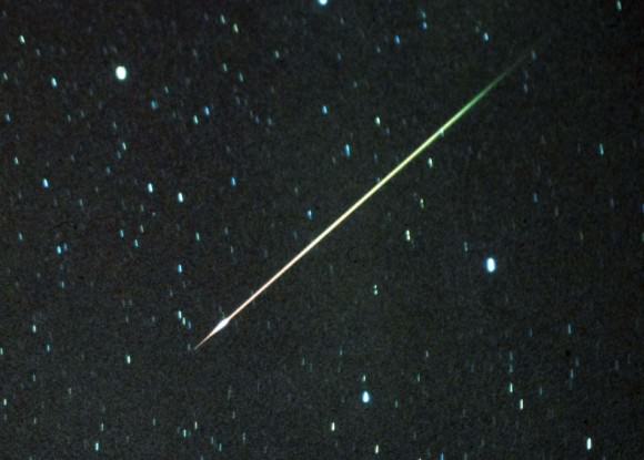
Most meteors are comet dust striking at the atmosphere at speeds so high, they vaporiz in a blaze of light. This is a meteor from the Leonid shower in 2001. Credit: Bob King
No one’s certain of the Arietids’ parentage. Likely candidates include the near-Earth asteroid 1566 Icarus and Comet 96P/Machholz, both of which have orbits that resemble the shower’s.
After ignoring May’s Eta Aquarid meteor shower for years because of its very low radiant at dawn, I was pleasantly surprised by the many meteors I saw when I happened to catch the shower at maximum on May 6 this year. Circumstances are only slightly worse for the Arietids. That’s why I think it’s worth your while to check out this shower tomorrow (Friday) and Saturday morning(June 7-8). Face east and start watching an hour or two before the start of dawn and continue your vigil until the sky brightens in the east.
The lesser Zeta Perseids are also active, adding to the fun. Since the two shower radiants are close to each other in the sky, it may be hard to tell which you’re seeing. No matter. Any fiery streaks you can trace back toward the east-northeast horizon will likely be one or the other.
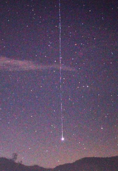
Earth-grazing meteor photographed by Manuel Conde of Barcelona, Spain.
Whenever a radiant is near the horizon, many of the meteors approaching us do so at a very shallow angle almost horizontal to the Earth’s atmosphere. From our perspective they travel slowly and last a much longer time than do meteors striking the air at a steeper angle, typical for radiants that are higher in the sky.
Astronomers use the poetic “Earth-grazers” to describe them. Having seen a handful of these unique beauties during the May Aquarid shower, I’m hungry for more. Since the Arietids / Zeta Perseids also originate low in the sky, we should expect similar sights Friday and Saturday mornings.
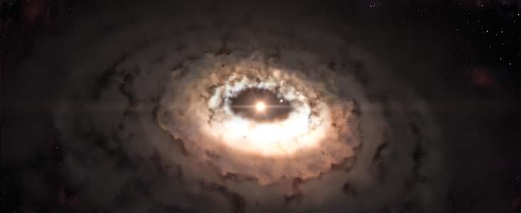
This artist’s impression shows the dust trap in the system Oph-IRS 48. The dust trap provides a safe haven for the tiny rocks in the disc, allowing them to clump together and grow to sizes that allow them to survive on their own. Credit: ESO/L. Calçada
“Ooompah, loompah, roopity rust… ALMA finds comets hiding in dust.” According to many studies over recent years, astronomers are aware planets seem to be everywhere around stars. However, just how these rocky bodies, including comets, are created is something of an enigma. Now, thanks to one sweet telescope, the Atacama Large Millimeter/submillimeter Array (ALMA), science has taken a big step forward in understanding how minuscule dust grains in a protoplanetary disk can one day evolve into a larger format.
A little less than 400 light years from Earth is a youthful solar system cataloged as Oph IRS 48. In images taken of its outer perimeters, astronomers have picked up a vital clue in its swirling masses of dust – a crescent-shaped region dubbed a “dust trap”. Researchers feel this area may be a protective cocoon which allows rocky formations to take shape. Why is such a region important? It’s the smash-factor. When astronomers try to model dust to rocky formations, they have found the particles self-destruct… either by crashing into each other, or being drawn into the central star. In order for them to progress past a certain size, they simply must have an area of protection to allow them to grow.
“There is a major hurdle in the long chain of events that leads from tiny dust grains to planet-sized objects,” said Til Birnstiel, a researcher at the Harvard-Smithsonian Center for Astrophysics in Cambridge, Mass., and co-author on the paper published in the journal Science. “In computer models of planet formation, dust grains must grow from submicron sizes to objects up to ten times the mass of the Earth in just a few million years. But once particles grow larger enough, they begin to pick up speed and either collide, sending them back to square one, or slowly drift inward, thwarting further growth.”
So where can a newborn planet, comet or asteroid hide? Nienke van der Marel, a PhD student at Leiden Observatory in the Netherlands, and lead author of the article, was using ALMA along with her co-workers, to take a close look at Oph IRS 48 and discovered a torus of gas with a central hole. This absence of dust particles was very different from earlier results picked up on ESO’s Very Large Telescope.
“At first the shape of the dust in the image came as a complete surprise to us,” says van der Marel. “Instead of the ring we had expected to see, we found a very clear cashew-nut shape! We had to convince ourselves that this feature was real, but the strong signal and sharpness of the ALMA observations left no doubt about the structure. Then we realised what we had found.”
A surprise? You bet. What the team uncovered was a region where large dust grains remained captive and could continue to gain mass as more and more grains collided and melded together. Here was the “dust trap” which theorists predicted.
Loading player…
So what makes it up? To keep the dust grains together and forming requires a vortex – an area of high pressure to protect them. To form this vortex, there needs to be a large object present, either a companion star or a gas-giant. Like a boat sluicing through algae-filled waters, the secondary object in the planetary disk would clear a path in its wake, producing the critical eddies and vortices needed to fashion the dust trap. While previous studies of Oph IRS 48 uncovered a rigid ring of carbon monoxide gas combined with dust, there was no observed “trap”. However, that doesn’t mean the observation was negative. Astronomers also uncovered a gap between the inner and outer portions of the solar system – a clue to the presence of the necessary large body.
The conditions were right for a possible dust trap. Enter ALMA. Now the researchers were able to see both the gas and larger dust grains at the same time. These new observations led to a discovery no other telescope had yet revealed… a lopsided bulge in the outer portion of the disk.
As van der Marel explains: “It’s likely that we are looking at a kind of comet factory as the conditions are right for the particles to grow from millimetre to comet size. The dust is not likely to form full-sized planets at this distance from the star. But in the near future ALMA will be able to observe dust traps closer to their parent stars, where the same mechanisms are at work. Such dust traps really would be the cradles for new-born planets.”
As larger particles migrate towards the areas of higher pressure, the dust trap takes shape. To validate their findings the researchers employed computer modeling to show that a high pressure region could arise from the motion of the gas at the opening edges. It matches with the observation of the Oph IRS 48 disc.
“The combination of modelling work and high quality observations of ALMA makes this a unique project”, says Cornelis Dullemond from the Institute for Theoretical Astrophysics in Heidelberg, Germany, who is an expert on dust evolution and disc modelling, and a member of the team. “Around the time that these observations were obtained, we were working on models predicting exactly these kinds of structures: a very lucky coincidence.”
“This structure we see with ALMA could be scaled down to represent what may be happening in the inner solar system where more Earth-like rocky planets would form,” said Birnstiel. “In the case of these observations, however, we may be seeing something analogous to the formation of our Sun’s Kuiper Belt or Oort Cloud, the region of our solar system where comets are believed to originate.”
Like that dream factory of our childhood, ALMA is still under construction. These unique observations were taken with the ALMA Band 9 receivers – European-made instrumentation which permits ALMA to deliver its sharpest, most detailed images so far.
“These observations show that ALMA is capable of delivering transformational science, even with less than half of the full array in use,” says Ewine van Dishoeck of the Leiden Observatory, who has been a major contributor to the ALMA project for more than 20 years. “The incredible jump in both sensitivity and image sharpness in Band 9 gives us the opportunity to study basic aspects of planet formation in ways that were simply not possible before.”
Will NASA's stellar education and outreach programs be cut?
The first Moon landing inspired a whole generation of scientists and engineers. And NASA, to its great credit, didn’t rest on those laurels: Outreach programs attached to the different NASA missions became a standard mode of operation. Some have reached legendary status. Without outreach, and the broad public support it engendered, the Hubble Space Telescope quite probably wouldn’t have had its faulty vision corrected.
And, not least thanks to the Internet, many NASA resources are available worldwide, and have a substantial impact on outreach efforts in other countries. (And in case you were wondering: yes, that’s the reason that I as a German am writing this blog post about NASA and, later on, about US policy. We profit from NASA resources – thanks! – and if NASA outreach loses, you lose, and we lose.)
One of the reasons science outreach by NASA and similar organizations is so powerful is the sheer fascination of black holes, distant galaxies, planets around distant stars, human space-travel, the big bang, or plucky little rovers exploring Mars. But there is another important factor, and that is the direct involvement of scientists and engineers who are immersed in, and passionate about, what they do. Quoting from a slightly different context:
“[The] ability to impart knowledge, it seems to me, has very little to do with technical method. […] It consists, first, of a natural talent for dealing with children, for getting into their minds, for putting things in a way that they can comprehend. And it consists, secondly, of a deep belief in the interest and importance of the thing taught, a concern about it amounting to a sort of passion.
A man who knows a subject thoroughly, a man so soaked in it that he eats it, sleeps it and dreams it—that man can always teach it with success, no matter how little he knows of technical pedagogy. That is because there is enthusiasm in him, and because enthusiasm is almost as contagious as fear of the barber’s itch. […] This passion, so unordered and yet so potent, explains the capacity for teaching that one frequently observes in scientific men of high attainments in their specialties […]”
We might not fear the barber’s itch quite as much as they did in the 1920s, when American journalist and essayist, H. L. Mencken, wrote those lines. But Mencken’s main message is as true now as it was back then. The best science outreach projects I’ve seen — and as managing scientist of a Center for Astronomy Education and Outreach I try to keep reasonably up to date — directly involve people whose enthusiasm for their subject is contagious — scientists communicating their own research, or outreach scientists and educators working closely with researchers.
That’s the reason why I’m worried about the future of NASA education and public outreach. There is, right now, a major effort by the Obama administration to restructure federal STEM education efforts (STEM being Science, Technology, Engineering, and Math). Apparently, the committee known as CoSTEM that is the driving force of this initiative didn’t do a very good job in engaging outreach practitioners in a dialogue about the changes, because the first thing many of those active in the field heard about the sweeping changes were ominous statements in the administration’s NASA Budget Proposal for Fiscal Year 2014, published on April 10 (PDF 34 MB).
NASA’s Leland Melvin talks with Tweet-up participants at the STS-133 launch in February, 2011. Credit: Nancy Atkinson.
The proposal is somewhat sketchy on the details, but what was there was worrying enough for a number stakeholders to speak up: Phil Plait, who used to be himself involved in mission-based outreach, has commented on the “bad news”, and Pamela Gay, whose group is responsible for CosmoQuest, among other projects, has weighed in (also here) — her group largely depends on the kind of NASA funding that could be eliminated in the restructuring. More recently, the American Astronomical Society has issued a Statement on Proposed Elimination of NASA Science Education & Public Outreach Programs.
On June 4, there was a hearing of the House Committee on Science, Space and Technology (the link has an archived webcast of the hearing, as well as some written statements). Judging by some of the answers at the hearing, the implementation of the restructuring hasn’t been fully worked out yet — but what information is out there is indeed somewhat worrying. It sounds like an efficiency-and-evaluation drive with little regard for the power of scientific passion.
The proposal calls for slashing NASA’s budget for education by almost a third. It promises that NASA’s “education efforts will be fundamentally restructured into a consolidated education program funded through the Office of Education, which will coordinate closely with the Department of Education, the National Science Foundation, and the Smithsonian Institution”. In particular, the consolidation concerns the outreach activities connected directly to the various missions: “mission-based K-12 education, public outreach, and engagement activities, traditionally funded within programmatic accounts, will be incorporated into the Administration’s new STEM education paradigm in order to reach an even wider range of students and educators”.
The Smithsonian Institution will take the lead on informal outreach and engagement. It’s not quite clear what that means, but they will get $25 million to do it. They have apparently promised to interact very closely with the mission agencies they would be “helping” in their role of “clearing house” for this kind of activity. Does that mean that they will become the main agency to develop outreach materials — will NASA missions have to provide them with information about their science, and receive custom-made (or not) outreach kits in return? Or will they have more of an advisory capacity — will they somehow assist NASA outreach units to develop material, and help with the distribution? Your guess is as good as mine.
A number of committee members expressed their concern in this direction, as well, asking about the role of their local institutions such as science museums, STEM initiatives and the like in the new scheme. The answers weren’t very encouraging. There was talk of strong partnerships being developed, but apparently the desire to build partnerships didn’t go as deep as actually trying to communicate with those stakeholders beforehand.
Committee member Elizabeth Esty (D-CT) actually raised the matter that is my main concern in this blog post: she talked about the importance of engaging science practitioners and engineers directly, having them interact with school students; she also talked about the excitement for science that NASA has been so good at generating.
Again, the answers weren’t very encouraging (this is around 1h 40m into the hearing). The NSF representative (Joan Ferrini-Mundy) talked about the increased reach the Department of Education could provide, and the NASA representative (Leland D. Melvin) went down the same road, praising how the Department of Education was helping NASA to make their hands-on activities available in more states than ever before. Neither appeared to have understood that the question was about something altogether different than mere efficiency in the distribution of educational materials.
Participation in classrooms from NASA personel might be a thing of the past. Here, Kristyn Damadeo from a project called SAGE III on ISS project reads to students during Earth Science Week. Credit: NASA
And while the inspiration by astronauts interacting with school students, or the excitement generated by the direct contact with researchers, was at least mentioned during the hearing, the role of outreach scientists — as mediators with a background in science and a job in science communication — was completely absent from the hearing and, incidentally, from the CoSTEM documents.
To me, all of this appears to add up to a move into precisely the wrong direction. For powerful science outreach, you want to channel the passion of the researchers/engineers through the educators and outreach scientists; to that end, you want the connections between those groups to be as close as possible.
A small-to-medium-size outreach team working directly with one or a few missions fits the bill. Replace local teams with large, centralized entities responsible for a much wider portfolio of activities and missions, and you are bound to lose those immediate connections. So, by all means, consolidate where consolidation makes sense — centralized distribution, centralized services such as graphics or video editing, web services, consultation with experienced educators, a school partnership network coordinated by the Department of Education, or what have you — but mission-based outreach scientists and educators do not fall into that category.
If the “new paradigm” widens the gap between the scientists and engineers on the one hand and the educators and outreach scientists on the other, that’s bad news for NASA outreach.
The good news is that the committee demonstrated considerable interest in the matter — and a healthy dose of skepticism. Several members talked about the questions they had received from constituents and stakeholders about the reform. Some remarked on having seldomly seen the meeting room as crowded.
After June 4, committee members apparently still have two weeks to submit their written questions to the witnesses: to presidential science advisor John Holdren, NSF assistant director in the Directorate for Education and Human Resources, Joan Ferrini-Mundy, and Leland D. Melvin, who’s the Associate Administrator for Education at NASA. And a number of committee members (watch the webcast!) seemed quite aware that there are open questions, reasons for skepticism, and room for discussion.
So there’s your chance to do something for NASA (and other agencies’) outreach:Here is a list of the committee members. Express your concern. Ask them what the changes will mean for existing programs (here is a complete list of the programs concerned). Remind them that this is not only about abstract numbers, but about people. The way things are organized right now, there are many individual outreach scientists, researchers, engineers, educators who’ve spent years gaining experience with, and coming up with innovative ideas for, communicating their science. That’s a considerable resource right there — so what will happen with those people and their expertise under the new scheme?
If you have a favourite mission, outreach program or activity (Chandra, CosmoQuest, Hubble, …), ask the committee members how it will be affected by the consolidation. What will happen to the people who made the program/activity what it is? And do so soon, so the committee members can pass their questions and concerns on to the people responsible for this restructuring. This restructuring seems to be something of a turning point for federally funded science outreach in the US (and, yes, for all of us in the rest of the world who profit from that outreach as well). If you or your children have profited from any of those outreach activities, here’s your chance to give something back.
Image taken by Italian astronaut Luca Parmitano from the International Space Station, who said, 'Maybe one day our settlements on Mars will look like this." Credit: NASA/ASI
This sure looks like a futuristic settlement on the Red Planet, as Italian astronaut Luca Parmitano pondered on Twitter yesterday when he shared this image taken from the International Space Station, saying, “Maybe one day our settlements on Mars will look like this.”
But what is this facility — which must be huge and looks to be out in the middle of absolutely nowhere? A secret new branch at Area 51? A mock-up of a base from the “Legion of Space” sci-fi books?
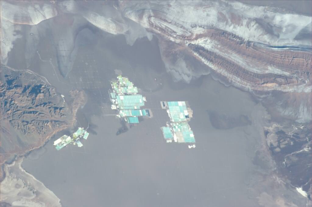
It’s actually one of the world’s largest lithium salt production facilities, located in the “lithium triangle” of Argentina, Chile and Bolivia, high in the Atacama desert in Chile. Below is an aerial view:
An aerial view of the brine pools and processing areas of the Soquimich lithium mine on the Atacama salt flat, the largest lithium deposit currently in production, in the Atacama desert of northern Chile, on Jan. 10, 2013. Credit: Ivan Alvarado / Reuters.
You can read a great article here (with more great images) about the lithium mining operations, enabling all your electronic gizmos to be powered.
This is an article from our archive, but we’ve updated it with this spiffy video.
Every now and then I go looking for a free aerial view of my home. It’s amazing what’s available through the internet now, totally free. Thanks to commercial Earth observation satellites, and internet tools that make these photos accessible through the internet, it’s easy to see your house from space.
In our modern space age, there are more than 8,000 satellites currently orbiting the Earth. The vast majority of these are relaying data to and from the Earth, and many are equipped with high power cameras. Just look up into the sky any night, and you’re sure to see satellite after satellite passing overhead. But what are some ways you can get access to these satellite and aerial images of your house?
Satellite Images of the Whole Earth
If you want to go way out and just see a satellite image of the entire planet, there are some solutions for you: weather satellites. For example, NOAA’s Geostationary Operational Environmental Satellites (GOES) release images of an entire hemisphere of planet Earth every 3 hours. From these images you can see major weather patterns affecting parts of the Earth. But you really can’t see any specific spot on Earth with any detail.
What is really cool about these satellite views is that they’re live. The weather systems you’re seeing in those images are happening on the planet right now.
If you don’t want a live view, and really just want to see a beautiful view of the Earth’s hemisphere, check out these images produced by NASA. Here’s a composite photograph that shows the Earth’s Western Hemisphere, and here’s a view of the Earth’s Eastern Hemisphere.
Zoom in. Let’s see Satellite Pictures of Houses
If those whole Earth pictures don’t give you enough detail, let’s zoom in, and see some pictures of houses from space. The best tool on the market, in my opinion, is the service from Google Maps. All you need is a web browser and a connection to the internet. When you first start up, Google Maps displays a satellite view of North America. You can then zoom in, or pan the camera around to see any location on Earth. You can also type in the address of the location that you want to see. Once you do that, you’ll get a free satellite view of your house. You can save the image or print it off.
Another cool tool from Google is Google Earth. You can access by going to http://earth.google.com. The main difference between Google Maps and Google Earth is that you have to download and install Earth on your local computer (they have a version for PCs, Mac, Linux, and even the iPhone). Once you’ve downloaded and installed Google Earth, you can see a 3-dimensional view of Earth that you can zoom in and out and spin around. You can type in your address and get a view of your house from above. I actually like the printing function of Google Earth better, since it’s using your printer directly, and not going through the web browser.
And if you really hate using products from Google, no problem. There are similar services from Yahoo and Microsoft. Microsoft’s mapping service used to be called MSN Maps, and now it’s been changed to Bing Maps with their new identity. The Yahoo service is called Yahoo Maps, and it’s very similar to Google Maps. The two services do have some big differences, though, and there’s a cool application that lets you see the two of them side-by-side. I used it for my home and found that Google Maps has better resolution maps for my city.
Where Do All these Pictures Come From?
Google Maps and the other internet mapping services are really just customers for the satellite services that actually take these photographs from space. There are a few major services on the market, including GeoEye. GeoEye’s main competitors include DigitalGlobe and Spot Image.
Each company has a fleet of Earth observation satellites, with a capability of resolving features on the surface of the Earth as small as about 45 cm (18 inches). In other words, an object 45 centimeters across would appear as a single pixel in their photographs.
Each of these services allow customers to purchase satellite imagery directly, but I’ll warn you, the prices are extremely high: hundreds or even thousands of dollars for satellite imagery. You typically can’t buy directly from the satellite company itself, but through their international partners.It’s better to stick to the free sources.
Are These Live Satellite Views?
When you look at these amazing views of your house from space, you might wonder if this is live. If you walk outside and look up, will you be able to see yourself from space? Unfortunately, no. All of the free satellite images you’re accessing were captured by various spacecraft over the last couple of years.
You can actually get a pretty good sense of when the picture was taken by the image of your property. For example, in the photo of my house from space, I can see a car that I sold a couple of years ago. Obviously, this image isn’t live, it’s at least a couple of years old – even a decade old in some cases. A live satellite view of your house, is still a few years off.
There are some services which will give you a live view of Earth from space. For example, you can access a live broadcast from NASA’s International Space Station. About 40% of the time, if you follow this link you can see a live view of Earth from the space station. Another service called Urthecast will be attaching a high definition camera to the International Space Station in 2013 to broadcast a live view of Earth from space.
Yesterday, June 5, the European Space Agency launched their ATV-4 Albert Einstein cargo vessel from their spaceport in French Guiana. Liftoff occurred at 5:52 p.m. EDT (2152 GMT), and in addition to over 7 tons of supplies for the ISS a special payload was also included: the DLR-developed STEREX experiment, which has four cameras attached to the Ariane 5ES rocket providing a continuous 3D view of the mission, from liftoff to separation to orbit and, eventually, docking to the Station on June 15.
The dramatic video above is the first-ever of an ATV vehicle going into free-flight orbit — check it out!
“The highlight of the STEREX deployment will be observing the settling of ATV-4 in orbit. STEREX for this event will include three-dimensional video sequences to study the dynamic behavior of the spacecraft during the separation phase. This opens up for the ATV project engineers an entirely new way to monitor the success of their work and also to gain important new experiences for the future.” – DLR blog (translated)
If you look along the horizon at around 5:20, you can make out the plume from the launch.
At 20,190 kg (44, 511 lbs) ATV Albert Einstein is the heaviest spacecraft ever launched by Ariane. Read more here.
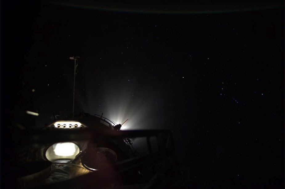
An image from the ISS in 2012 showing re-boost thrusters firing. Credit: NASA.
Here’s a follow-up on an interesting image we posted last year, during Don Pettit’s stay on the International Space Station during Expedition 30/31. Pettit had posted this beautiful, sci-fi-looking image on his Google+ page, but didn’t say what it was, only describing it as “Orion in the headlights.” The constellation Orion is off in the distance, but there was some debate about what the light source was: was it light coming from a window on the ISS or a thruster burn?
It turns out this is likely one of the first ever-images of a thrust-burn taken (or released) from the ISS. An Debris Avoidance Maneuver took place at 10.12 GMT (5:12 a.m. EST) on February 29, 2012 and G+ commenter Peter Caltner pointed out, “the scenic lighting effect ends exactly in [the series of images that Pettit took] at the end of the 76 seconds of the burn duration.”
Engineers at Johnson Space Center confirmed to Universe Today this was in fact a thruster burn from the thrusters located on the aft end of the Zvezda Service Module.
The JSC team told us that during a burn, most of the windows are covered so they don’t get damaged so there’s not a lot of opportunity to take a picture like this. But the astronaut or cosmonaut that took this image was in the Pirs module looking toward the aft end of the Service Module, where the reboost engines are located. The “downward” -facing window (looks “up” in this image) is the large observation window in the Russian Zvezda Service Module.
But does this actually show a thruster plume?
Very likely, the light seen here is not actually the light from the rockets after igniting for lifting the station. Caltner, who regularly answers questions from the public on Twitter and G+ about images from space, said the light probably comes from the docking headlights, switched on deliberately for illuminating the exhaust gases of the booster rockets.
It’s an intriguing shot, and the debate on it (and finding out more about it) has been fascinating and interesting!


