This question comes from Andrew Bumford and Steven Stormont.
In a previous episode I’ve talked about how the entire Solar System collapsed down from a cloud of hydrogen and helium left over from the Big Bang. And yet, we stand here on planet Earth, with all its water. So, how did that H20 get to our planet? The hydrogen came from the solar nebula, but where did the oxygen come from?
Here’s the amazing part.
The oxygen came from stars that lived and died before our Sun was even born. When those stars puffed out their final breaths of oxygen, carbon and other “metals”, they seeded new nebulae with the raw material for new worlds. We owe our very existence to the dead stars that came before.
When our Sun dies, it’ll give up some of its heavier elements to the next generation of stars. So, mix hydrogen together with this donated oxygen, and you’ll get H20. It doesn’t take any special process or encouragement, when those two elements come together, water is the result.
But how did it get from being spread across the early Solar System to concentrating here on Earth, and filling up our oceans, lakes and rivers? The exact mechanism is a mystery. Astronomers don’t know for sure, but there are a few theories:
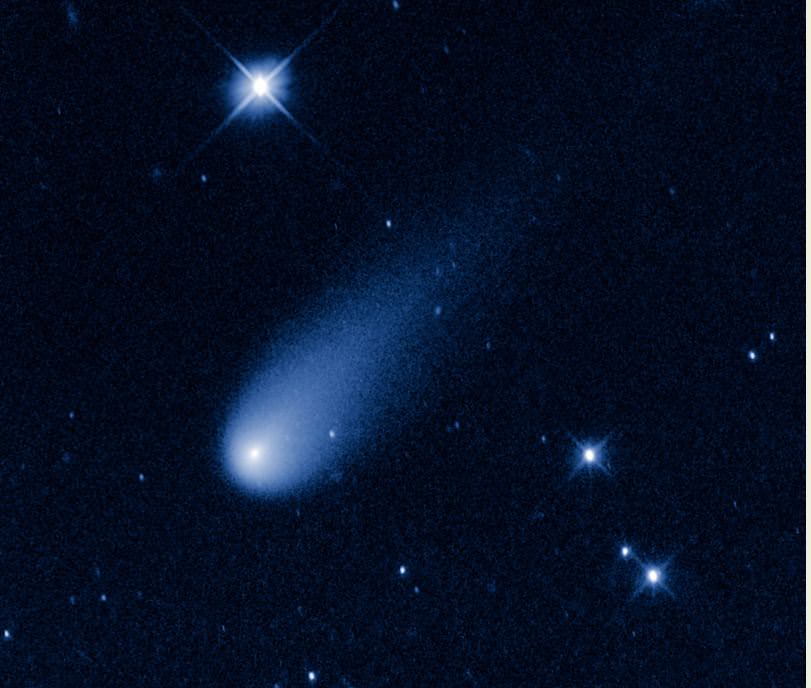
Idea #1: impacts. Take a look at the craters on the Moon and you’ll see that the Solar System was a busy place, long ago. Approximately 3.8 to 4.1 billion years ago was the Late Heavy Bombardment period, when the entire inner Solar System was pummeled by asteroids. The surfaces of the planets and their moons were heated to molten slag because of the non-stop impacts. These impactors could have been comets or asteroids.
Comets are 80% water, and would deliver vast amounts of water to Earth, but they’re also volatile, and would have a difficult time surviving the harsh radiation of the young Sun. Asteroids have a lower ratio of water, but they could protect that water a little better, delivering less with each catastrophic impact.
A false-color, visible-light image of Comet ISON taken with Hubble’s Wide Field Camera 3. Credit: NASA, ESA, and the Hubble Heritage Team (STScI/AURA)
Astronomers have also found many hybrid objects which contain large amounts of both rock and water. It’s hard to classify them either way.
Idea #2 is that large amounts of water just came directly from the solar nebula. As we orbited around the young Sun, it passed through the water-rich material in the nebula and scooped it up. Gravitational interactions between the planets would have transferred material around the Solar System, and it would have added to the Earth’s volume of water over hundreds of millions of years.
Of course, it’s entirely possible that the answer is “all of the above”. Asteroids and comets and the early solar nebula all delivered water to the Earth. Where did the Earth’s water come from? Astronomers don’t know for sure. But I’m sure glad the water is here; life here wouldn’t exist without it.
We’ve got a pretty bright Moon, but that just means we’ve got another target for the Virtual Star Party.
Tonight we had beautiful views of the Moon from David Dickinson and Cory Schmitz, and then some deep sky objects from Gary Gonella and Cory. We saw Andromeda Galaxy, Bubble Nebula, Swan Nebula, Lagoon Nebula, Dumbbell Nebula. And some viewers shared their photographs, including some amazing images of the International Space Station.
Host: Fraser Cain
Astronomers: Cory Schmitz, Gary Gonella, David Dickinson
We hold the Virtual Star Party every Sunday night as a live Google+ Hangout on Air. We begin the show when it gets dark on the West Coast. If you want to get a notification, make sure you circle the Virtual Star Party on Google+. You can watch on our YouTube channel or here on Universe Today.
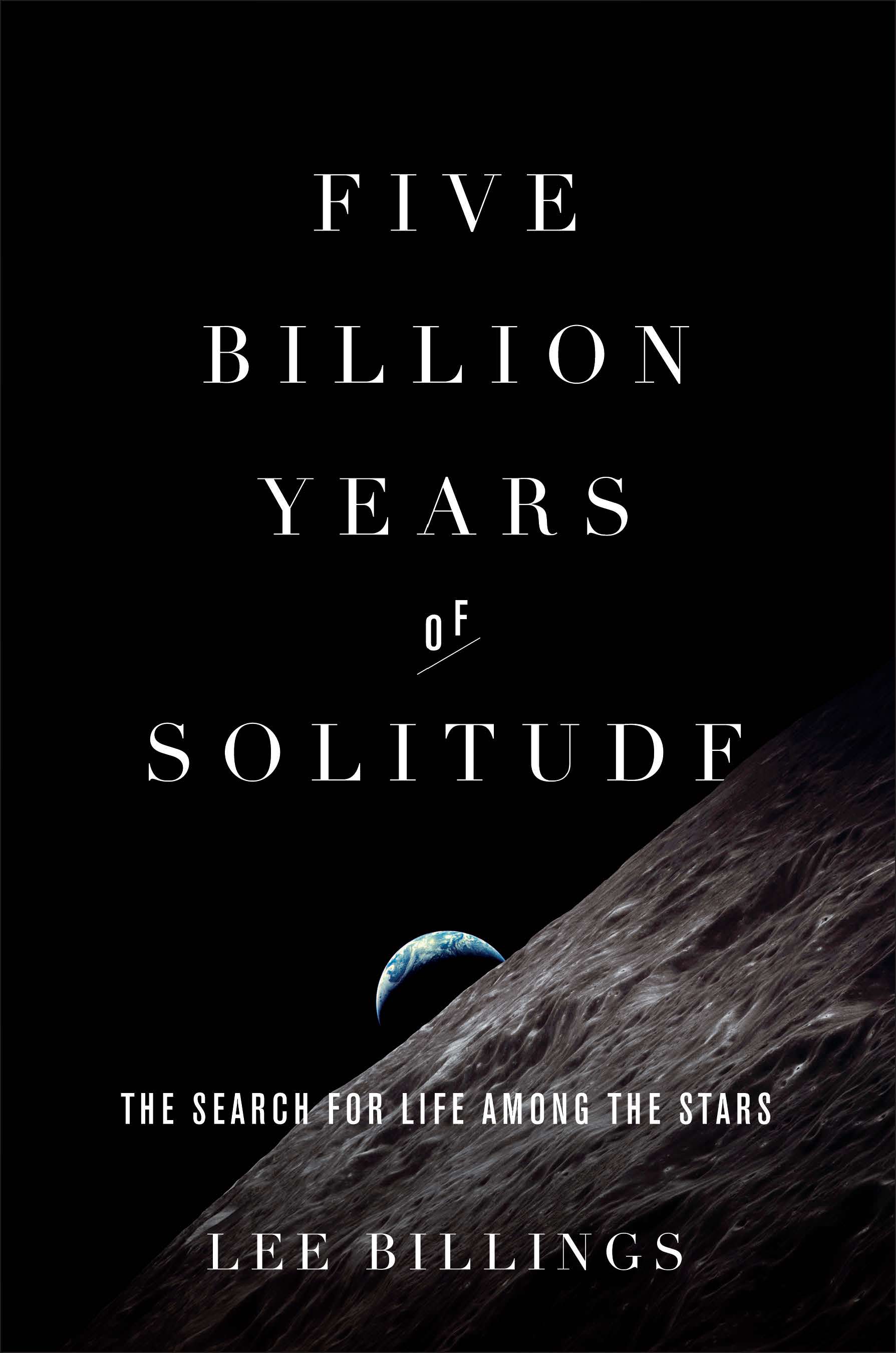
A new book, “Five Billion Years of Solitude,” takes reader from the earliest SETI searches and discoveries in astrobiology to the latest detections of thousands of planets orbiting other stars — all while giving us a glimpse inside the minds of some of the field’s most notable scientists.
You can read our full review of the book here and our Q&A interview with author and journalist Lee Billings here.
Universe Today is proud to announce we have three copies of this engaging book to give away. The publisher has specified that for this contest, winners chosen from the US will be sent a copy of the book, while winners chosen from other countries will receive an ebook.
In order to be entered into the giveaway drawing, just put your email address into the box at the bottom of this post (where it says “Enter the Giveaway”) before Wednesday, October 16, 2013. We’ll send you a confirmation email, so you’ll need to click that to be entered into the drawing.
We’re only going to use these email addresses for Universe Today giveaways/contests and announcements. We won’t be using them for any other purpose, and we definitely won’t be selling the addresses to anyone else. Once you’re on the giveaway notification list, you’ll be able to unsubscribe any time you like.
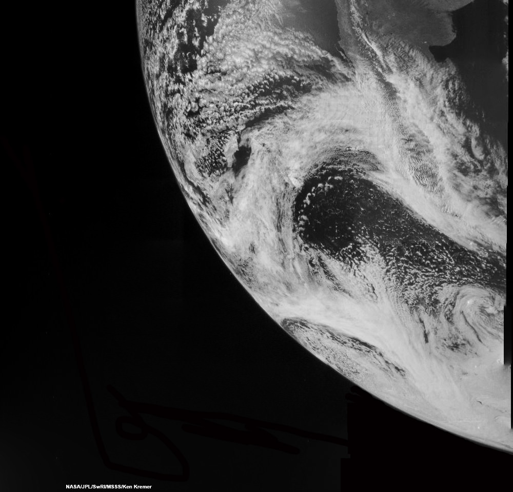
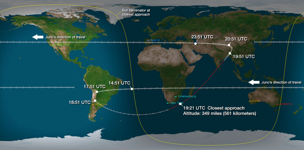
Juno swoops over Argentina This reconstructed day side image of Earth is one of the 1st snapshots transmitted back home by NASA’s Jupiter-bound Juno spacecraft during its speed boosting flyby on Oct. 9, 2013. It was taken by the probes Junocam imager and methane filter at 12:06:30 PDT and an exposure time of 3.2 milliseconds. Juno was flying over South America and the southern Atlantic Ocean. The coastline of Argentina is visible at top right. Credit: NASA/JPL/SwRI/MSSS/Ken Kremer
Juno swoops over Argentina
This reconstructed day side image of Earth is one of the 1st snapshots transmitted back home by NASA’s Jupiter-bound Juno spacecraft during its speed boosting flyby on Oct. 9, 2013. It was taken by the probes Junocam imager and methane filter at 12:06:30 PDT and an exposure time of 3.2 milliseconds. Juno was flying over South America and the southern Atlantic Ocean. The coastline of Argentina is visible at top right. Credit: NASA/JPL/SwRI/MSSS/Ken Kremer
See another cool Junocam image below[/caption]
Engineers have deftly managed to successfully restore NASA’s Jupiter-bound Juno probe back to full operation following an unexpected glitch that placed the ship into ‘safe mode’ during the speed boosting swing-by of Earth on Wednesday, Oct. 9 – the mission’s top scientist told Universe Today late Friday.
“Juno came out of safe mode today!” Juno principal investigator Scott Bolton happily told me Friday evening. Bolton is from the Southwest Research Institute (SwRI), San Antonio, Texas.
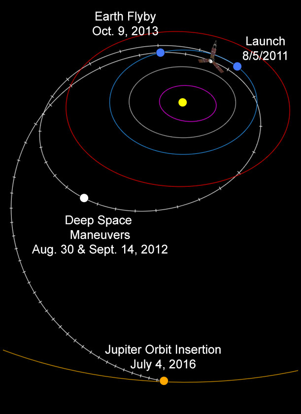
The solar powered Juno spacecraft conducted a crucial slingshot maneuver by Earth on Wednesday that accelerated its velocity by 16,330 mph (26,280 km/h) thereby enabling it to be captured into polar orbit about Jupiter on July 4, 2016.
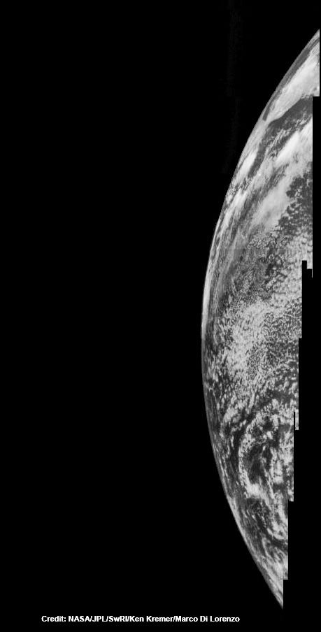
Dayside view of a sliver of Earth snapped by Juno during flyby on Oct. 9, 2013. This mosaic has been reconstructed from raw image data captured by methane infrared filter on Junocam imager at 11:57:30 PDT. Credit: NASA/JPL/SwRI/MSSS/Ken Kremer/Marco Di Lorenzo
“The safe mode did not impact the spacecraft’s trajectory one smidgeon!”
Juno exited safe mode at 5:12 p.m. ET Friday, according to a statement from the Southwest Research Institute. Safe mode is a designated fault protective state that is preprogrammed into spacecraft software in case something goes amiss.
“The spacecraft is currently operating nominally and all systems are fully functional,” said the SwRI statement.
Although the Earth flyby did accomplish its primary goal of precisely targeting Juno towards Jupiter – within 2 kilometers of the aim point ! – the ship also suffered an unexplained anomaly that placed Juno into ‘safe mode’ at some point during the swoop past Earth.
“After Juno passed the period of Earth flyby closest approach at 12:21 PM PST [3:21 PM EDT] and we established communications 25 minutes later, we were in safe mode,” Juno Project manager Rick Nybakken, told me in a phone interview soon after Wednesday’s flyby of Earth. Nybakken is from NASA’s Jet Propulsion Lab in Pasadena, CA.
Credit: NASA/JPL
Nybakken also said that the probe was “power positive and we have full command ability.”
So the mission operations teams at JPL and prime contractor Lockheed Martin were optimistic about resolving the safe mode issue right from the outset.
“The spacecraft acted as expected during the transition into and while in safe mode,” acording to SwRI.
During the flyby, the science team also planned to observe Earth using most of Juno’s nine science instruments since the slingshot also serves as an important dress rehearsal and key test of the spacecraft’s instruments, systems and flight operations teams.
“The Juno science team is continuing to analyze data acquired by the spacecraft’s science instruments during the flyby. Most data and images were downlinked prior to the safe mode event.”
Juno’s closest approach took place over the ocean just off the tip of South Africa at about 561 kilometers (349 miles).
Juno launched atop an Atlas V rocket two years ago from Cape Canaveral Air Force Station, FL, on Aug. 5, 2011 on a journey to discover the genesis of Jupiter hidden deep inside the planet’s interior.
The $1.1 Billion Juno probe is continuing on its 2.8 Billion kilometer (1.7 Billion mile) outbound trek to the Jovian system.
During a one year long science mission – entailing 33 orbits lasting 11 days each – the probe will plunge to within about 3000 miles of the turbulent cloud tops and collect unprecedented new data that will unveil the hidden inner secrets of Jupiter’s origin and evolution.
“Jupiter is the Rosetta Stone of our solar system,” says Bolton. “It is by far the oldest planet, contains more material than all the other planets, asteroids and comets combined and carries deep inside it the story of not only the solar system but of us. Juno is going there as our emissary — to interpret what Jupiter has to say.”
Read more about Juno’s flyby in my articles – at NBC News; here, and Universe Today; here, here and here
After last week’s non-episode, the Weekly Space Hangout roared back to life. We had big news on the Government Shutdown, the Earth flyby from the Juno spacecraft, and a big update on Comet ISON.
We also had a special guest, author and journalist Lee Billings, who was here to talk about his newest book, Five Billion Years of Solitude. Lee talked about his work on the book, and the state of extrasolar planet research in general.
Here was the team:
Host: Fraser Cain
Panel: Casey Dreier, Nancy Atkinson, Amy Shira Teitel, Jason Major, and David Dickinson
We broadcast the Weekly Space Hangout every Friday afternoon as a Google+ Hangout on Air. You can watch us live on Google+, or on YouTube, or right here on Universe Today. We start at 12:00 pm Pacific / 3:00 pm Eastern.
Researchers work in the Antarctic polar night during a storm (Credit: Stefan Hendricks, Alfred Wegner Institute)
Some day, human explorers will land a spacecraft on the surface of Europa, Enceladus, Titan, or some other icy world and investigate first-hand the secrets hidden beneath its frozen surface. When that day comes — and it can’t come too soon for me! — it may look a lot like this.
One of a series of amazing photos by Stefan Hendricks taken during the Antarctic Winter Ecosystem & Climate Study (AWECS), a study of Antarctica’s sea ice conducted by the Alfred Wegener Institute in Germany, the image above shows researchers working on the Antarctic ice during a winter snowstorm. It’s easy to imagine them on the night-side surface of Europa, with the research vessel Polarstern standing in for a distant illuminated lander (albeit rather oversized).
Hey, one can dream!
One of the goals of the campaign, called CryoVex, was to look at how ESA’s CryoSat mission can be used to understand the thickness of sea ice in Antarctica. The extent of the Antarctic sea ice in winter is currently more than normal, which could be linked to changing atmospheric patterns.
Antarctica’s massive shelves of sea ice in winter are quite dramatic landscapes, and remind us that there are very alien places right here on our own planet.
See this and more photos from the mission on the ESA website (really, go check them out!)
As far as our understanding of life in the Universe goes, right now, we’re it. But the past decade has brought discoveries of hundreds of planets orbiting other stars, some of which could potentially host life. Fellow science journalist Lee Billings has written a new book about the exciting field of searching for extrasolar planets. Five Billion Years of Solitude (read our review here) takes a look at some of the remarkable scientists and the incredible discoveries being made.
Earlier this week, we talked with Lee about the book and the future of how we might find a mirror of Earth.
Universe Today: What was the impetus behind writing this book – was there a specific event or moment where you said, ‘I want to write about astrobiology and the search for exoplanets,’ or was it a more gradual thing over time, where you were just intrigued by the whole expanding field?
Lee Billings
Lee Billings: A little bit of both. I was definitely intrigued by the expanding field of searching for exoplanets, but it came all together for me after interviewing astronomer Greg Laughlin from the University of California, Santa Cruz in 2007 for an infographic about exoplanets. Near the end of our conversation, he mentioned — rather off the cuff — that if you tracked the smallest exoplanets found year by year and graphed them out over time, the trend-line would indicate that we would find an Earth-sized exoplanet by 2011. And I thought, “Holy crap, that’s just four years away!”
I was struck by the disconnect where we could see this plain-as-day data, but the wider world didn’t realize or appreciate this. It also bothered me that we’d soon be finding potentially habitable other worlds, and yet have great difficulty actually determining if they were habitable or even inhabited. And so there was this observational disconnect too, and a lot of people who didn’t seem to care there was this disconnect.
UT: And now that finding exoplanets has made front page news, are you encouraged by how people from afar are viewing this field?
LB: Yes and no. Exoplanets have been in the news for years now. 10 to 15 years ago when astronomers like Geoff Marcy and Michel Mayor were finding the first exoplanets — honkin’ huge balls of gas orbiting close to their stars — it would make front page news. Right now, there’s kind of been ‘exoplanet fatigue,’ where every couple of days a new exoplanet is being announced and exoplanets are even less in the news now because of this overload. And it’s going to keep happening, and I feel like by 2020 finding an Earth-sized planet in the habitable zone isn’t going to make front-page news because it’s going to be happening all the time and people are getting used to it.
UT: Kind of like the Apollo program all over again, where people soon got tired of watching people walk on the Moon?
LB: Yes! Even though I feel like more people in the public are aware of exoplanets being discovered and they even think exoplanets are cool, many think that finding thousands of exoplanets is just like stamp collecting — oh, we found another planet, let’s put it in the book and isn’t that one really pretty — that’s not what this is about. It’s about finding signs of life, finding a sense of context for ourselves in the wider universe, figuring out where Earth and all life upon it fits in this greater picture. I don’t think people are attuned to that side, but are being seduced by the stamp-collecting, horse-race nature of how finding exoplanets are depicted in the media. The emphasis isn’t on what it is going to take to really go out and find out more details about these exoplanets.
Frank Drake and the Drake Equation,
UT: You had the opportunity to talk with some of the great minds of our time — of course, Frank Drake is just such an icon of SETI and the potential for finding life out there in the Universe. But I think one of the most amazing things in your book that I’d never heard of before comes in one of the first chapters where you’re talking with Frank Drake and his idea for a spacecraft that uses the Sun as a gravitational lens to be able to see distant planets incredible detail. That’s amazing!
LB: If you use the Sun as a gravitational lens as sort of an ultimate telescope is really fascinating. As Drake said in the book, you can get some mind-boggling, insane data if you used the Sun as a gravitational lens, and align that with another gravitational lens in the Alpha Centauri system and you can send a high bandwidth radio signal in between those two stars with just the power of a cell phone. In visible light, you could possibly see things on a nearby exoplanet like night-time lighting, the boundary between land and sea, clouds, and weather patterns. It just boggles the mind.
There are other techniques out there that could in theory deliver these sorts of similar observations, but there’s just kind of a technical sweetness to the notion that the stars themselves could be the ultimate telescopes that we use to explore the universe and understand our place in it. I think that’s kind of a wild, poetic and elegant idea.
UT: Wow, that is so compelling. And speaking of compelling, can you talk about Sara Seager and the time you were able to spend with her, getting to know her and her work? Her story is quite compelling not to mention heartbreaking.
LB: She’s a remarkable woman and a brilliant scientist and I feel deeply privileged and honored to be able to tell her story — and that she shared so many details of her personal story with me. Really, she’s kind of a microcosm of the field at large. She crossed over from what she originally studied — from cosmology to exoplanetolgy — and her career seems to be defined by the refusal to accept that certain things might be impossible. She is always pushing the envelope and just keeps her eyes on the prize, so to speak, of finding smaller more Earth-like planets that could be habitable and finding ways of determining what they are actually like. There’s a parallel there between her path and astronomy at large, where there is tension between parts of the professional community. A lot of astronomy is concerned with studying how the universe began and the ancient, the distant, the dead. Exoplanetology is more concerned with the nearest stars to Earth and the planets — the new, the nearby and the living. I feel like she represents that shift and embodies some of that tension.
There’s also an element of tragedy, where she suffered a significant loss with the death of her husband, and had to find a way to get through it and get stronger coming out on the other side. I see similarities between that and what has happened in the field at large where we’ve seen big federally funded plans for future, next-generation telescopes like the Terrestrial Planet Finder, be scuttled on the rocky reefs of politics — and other things. It’s complicated why that’s happened, but there’s no denying that is HAS happened. 15 years ago we were talking about launching TPS by 2014 and now here we are, almost to 2014 and the James Webb telescope isn’t even launched and its eating up all the money for everything else. And now the notion of doing these big kinds of life-finding missions have fallen by the wayside. There’s been kind of the death of a dream, and the bright future that was forecast for what was going to happen for exoplanets doesn’t seem like it’s going to be. The community has had to respond to that and rebuild from that, and there doesn’t seem to be a lot of unity on what the best path forward is.
And also, Sara Seager is walking the line between the old way of big, federally funded projects and a new private, philanthropic path that may or may not be sustainable or successful, but it’s different and trying to do science in a new way. So maybe we don’t need to rely on big government or NASA to do this. Maybe we could ask philanthropists or crowd-funding or new enterprises that could help finance the projects in going forward. She’s got her feet in both worlds and is emblematic of the field right now.
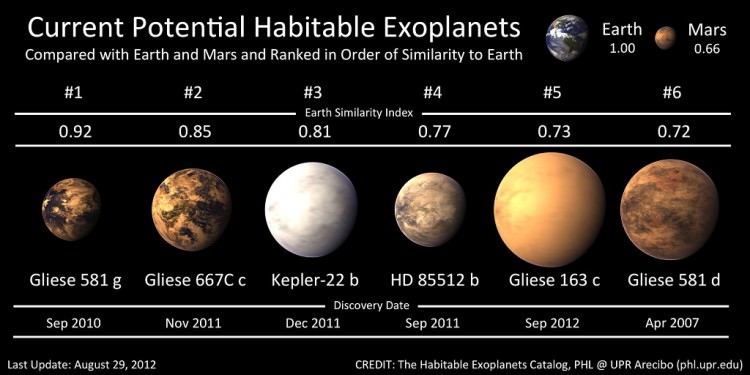
Artistic representations of the only known planets around other stars (exoplanets) with any possibility to support life as we know it. Credit: Planetary Habitability Laboratory, University of Puerto Rico, Arecibo.
UT: Yes, as you mention in the book, there is this tragic possibility that we may never find the things that these scientists are searching for — “mirror Earths, alien life, extraterrestrial intelligence, or a future beyond our lonely, isolated planet.” What do you see as the future of the search for exoplanets, in this age of funding cuts?
LB: What seems to be happening is that astronomers and planet hunters are needing to change their baselines and move their goalposts. In the past when people talked about space telescopes and finding signs of life, they were thinking of directly imaging planets around Sun-like stars and finding indications of life through studying the atmosphere and even surface features. The new way that is coming about and will likely happen in the next few decades, is an emphasis on smaller, cooler, less sun-like stars — the Red Dwarf or M-Dwarf stars. And it won’t be about directly imaging planets, but looking at transiting planets because it is easier to look at planets around lower-mass stars and at super-Earths that are easier to find and study. But these are rather alien places and we don’t know much about them, so it’s an exciting frontier.
But while transits are jackpots — in that you get all sorts of information like period, mass, radius, density and measures of the planet’s upper atmosphere — transits are very rare. If you think about the nearest thousand stars and if we are just looking for transits, that sort of search will only yield a fraction of the planets and the planetary diversity that exist. If you’re looking for life and potentially habitable planets, we really need a bigger sample and more than just transits to fill out the census of planets orbiting the stars around us.
I think missions like TESS and James Webb are going to be important, but I don’t think it will be enough. It will only leave us on the cusp of answering these bigger questions. I hope I’m wrong and that the emphasis on M-dwarfs and super-Earths and transits will be far more productive and surprising than anyone could have imagined or that there will be technology developed that are orders of magnitude cheaper, more affordable and better than these big telescopes.
But to answer the big questions more robustly in a way that is more satisfying to the public and data-hungry scientists, we’re probably going to have to make big investments, and invest the blood sweat and tears into building one of these big space telescopes. People in the astronomy community have been kicking and screaming about this because they realize the money just isn’t there.
But as someone once told me, there an economic inevitability to this in terms of how much the public can be engaged by these questions and how much they might hunger and thirst for finding other planets and life beyond our solar system. I feel like there is a strong push that could be made. I feel that the public would offer more support for these types of investments rather than for other projects, such as a a big space-based gravitational wave observatory or a big telescope devoted to studying dark energy.
Of course, we are living in this era of constrained and falling budgets, it’s going to be a really hard sell for any of these investments in astronomy, but pursuing the ancient, distant and dead instead of the new, nearby and living is probably a losing proposition, I do I wish astronomers the best of luck, but I hope they make the smart choice to prioritize the most publicly engaging science.
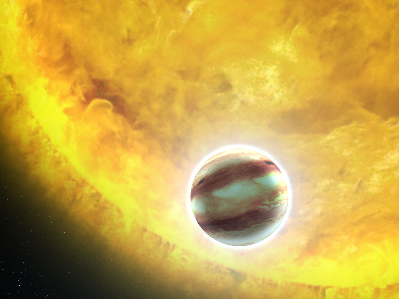
Artist’s impression of the transiting exoplanet HAT-P-7b. Credit: NASA/ESA
UT: You write about the competition and sometimes the disdain that competing astronomers have for each other. Is this competition good, or should there be more unity in the field?
LB: In the interest of the community at large, I’d have to say unity is better and that some people have to wait their turn or reduce their expectations. I’m biased; I’m an advocate of exoplanet missions and these investments. But this is publicly funded science and I think it’s important for the community to be unified because it’s all too easy for the bean-counters in Washington to hear the discordant cacophony coming from the various astronomer hatchlings in the nest, and that there is no consensus except they are hungry and they want more.
They need to be unified to withstand the anti-scientific trends in funding we are seeing in our federal government right now. On the other hand, competition is important. But when you are doing publicly funded science, the scientists need to do a good job of making their case of why they should be funded.
UT: What was the most memorable experience in writing this book?
LB: That’s a really hard question! One of my great privileges and joys of writing the book was having access to these scientists and their work. But one of the most memorable things was visiting California’s Lick Observatory on Mount Hamilton in 2012 for the Transit of Venus. It was the last transit of Venus in our lifetime and it was amazing to stand there and think that the last time the transit was visible from Mount Hamilton was a century before, and realize all the changes that had happened in astronomy since then. This transit happened slowly over hours and it was amazing to stand there and realize, this is the last time in your life you’re going to see it and to wonder what is going to happen in the intervening years until this event occurs again.
But Lick Observatory was an appropriate place to be since that’s where some of the first exoplanets were found. When the last Transit of Venus took place, we hadn’t walked on the Moon, there were no computers, and we’ve had all these great discoveries in astronomy. I was thinking about what the world will be like in another hundred years or so, and thinking how while that is a long time for us, in the scale of planetary time, it is nothing at all! The Sun won’t have significantly aged and Venus will likely look exactly the same in 2117 for the next transit, but I would guess the Earth will be very different then. It’s kind of indicative of this transitional era we’re in. It was a very poignant moment for me.
UT: It’s similar to how Frank Drake talked about how he and his colleagues thought that searching for radio emissions from other civilizations would be so important in the search for extraterrestrial intelligence, but realizing that Earth’s radio emissions from our technology is waning and only lasted a short period of time.
LB: Yeah, perhaps when people look back at my book in the future, they might say, ‘wow, this guy was so blinkered and stupid — he didn’t see this technologies X, Y and Z coming and didn’t see monumental discoveries A, B, and C coming.’ I kind of hope that’s actually the case, because it will mean the search for extraterrestrial life and intelligence will have surpassed my wildest dreams. However, I didn’t try to predict what was going to happen, but just wanted to capture this strange and seemingly unique moment in time in which we are poised on the threshold of these immense discoveries that could totally transform our conception of the Universe and our place in it.
UT: Talking to you today, we can obviously tell how passionate you are about this subject and you were the perfect person to write about it!
It is like coming around a corner and seeing the most magnificent sunset of your life, from one horizon to the other where it looks like the whole sky is on fire and there are all those colors, and the sun’s rays look like some great painting up over your head. You just want to open your eyes wide and try to look around at the image, and just try and soak it up. It’s like that all the time. Or maybe the most beautiful music just filling your soul. Or seeing an absolutely gorgeous person where you can’t just help but stare. It’s like that all the time.
Late in Hadfield’s final mission to space this May, when the Canadian Space Agency (CSA) astronaut was commanding the International Space Station Expedition 35 crew, an ammonia leak happened and NASA had to scramble a plan for a spacewalk, or extravehicular activity (EVA), to fix it. (The fix succeeded.) When Hadfield was apprised of the plan, he says in an excerpt from his forthcoming book, he was disappointed:
I wasn’t going out. I had a moment where I allowed myself to experience the full force of my disappointment. This would have been the heroic climax of my stint as commander: helping to save the ISS by doing an emergency spacewalk. I’d never have another chance to do an EVA—I’d already informed the CSA that I planned to retire shortly after returning to Earth.
But Chris [Cassidy] and Tom [Marshburn] had both done three previous EVAs, two of them together, on the same part of the station where ammonia was now leaking. They were the obvious people for the job. All this went through my head and heart for a minute or two, then I made a resolution: I was not going to hint that I’d had this pang of envy, or say, even once, that I wished I was doing the EVA. The right call had been made, and I needed to accept it and move on so that we could all focus on the main thing—the only thing, really: working the problem.
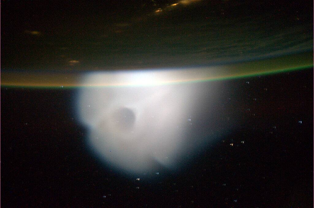
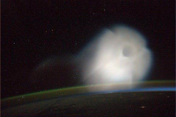
A strange but amazing cloud seen from the International Space Station. Credit: Mike Hopkins/NASA
The astronauts on board the International Space Station saw a strange and unexpected view out their windows yesterday. “Saw something launch into space today. Not sure what it was but the cloud it left behind was pretty amazing,” tweeted NASA astronaut Mike Hopkins.
ESA astronaut Luca Parmitano also got a shot of the cloud, as well as another picture of a contrail left from the launch.
So what launched into space? Of course, there was no launch from NASA because of the government shutdown, and I couldn’t find any other launches on the docket anywhere else, so I checked in with Robert Christy at the Zarya.info website, who usually knows of everything going up (or down) in space.
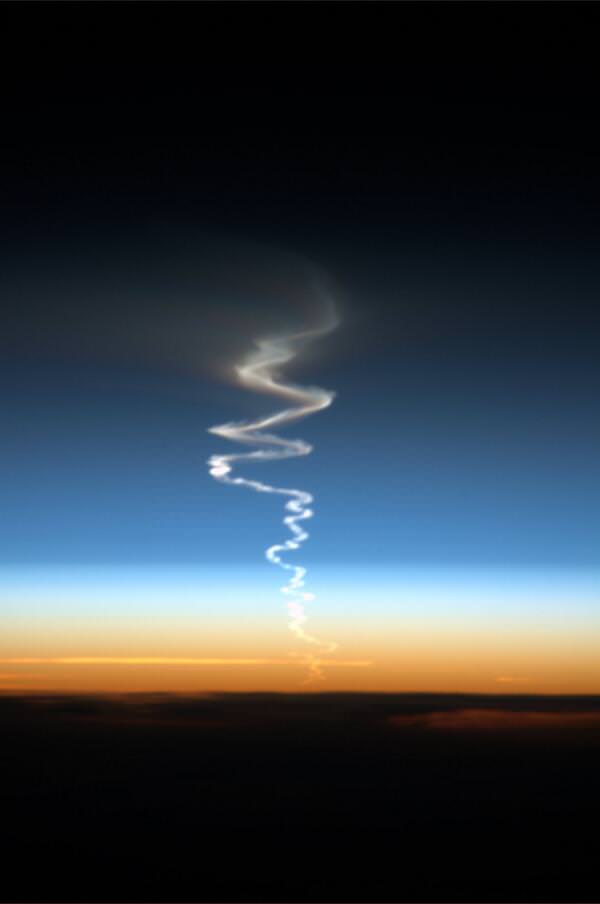
‘A missile launch seen from space: an unexpected surprise!’ tweeted ESA astronaut Luca Parmitano. Credit: ESA/Luca Parmitano.
“Without precise date, time and location it’s not possible to say for sure,” Christy replied, “I believe there was a missile launch from Kapustin Yar (Kazakhstan) on October 10 so if the photo was taken over the Eastern Europe or central Asia region than that might be what he saw.”
Strategic Rocket Forces carried out a successful test launch of a Topol/SS-25 missile on October 10, 2013. The missile was launched at 17:39 MSK (13:39 UTC) from Kapustin Yar to the Sary Shagan test site in Kazakhstan. According to a representative of the Rocket Forces, the test was used to confirm characteristics of the Topol missile, to test the systems of the Sary Shagan test site, and “to test new combat payload for intercontinental ballistic missiles.”
I had thought ICBM’s were a relic of the Cold War, but according to Wikipedia, “As of 2009, all five of the nations with permanent seats on the United Nations Security Council have operational long-range ballistic missile systems: all except China have operational submarine-launched missiles, and Russia, the United States and China also have land-based ICBMs (the US’ missiles are silo-based, China and Russia have both silo and road-mobile missiles).” Additionally, Israel launched an ICBM test in 2008, India test-fired one in 2012 and there was much speculation that a launch by North Korea in December 2012 to put a satellite into orbit was really a way to test an ICBM.
Parmitano also got an image of the cloud:
Another view of the cloud in space from the missile launch. Credit: ESA/Luca Parmitano.
“An immense cloud forms outside the atmosphere after the disintegration,” Parmitano said via Twitter.
Robert Christy noted that at the launch time noted by the RussianForces website, the ISS was over Iran, heading northeast towards Mongolia, and the Sun was about to set at Kapustin Yar.
“The view from the ISS would have been with a low sun angle, shining ‘over the photographer’s shoulder’ – hence the rather striking image against a darkish background with no glare from the Sun,” Christy told Universe Today via email.
Oh, the things you can see out your window in space!
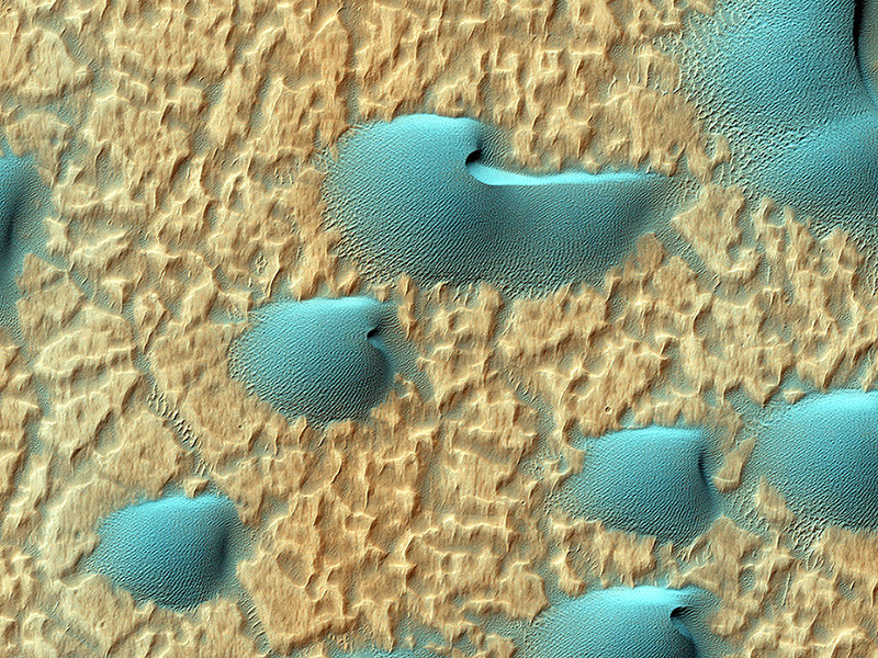
Dunes in Noachis Terra on Mars. Credit: NASA/JPL/University of Arizona
Who doesn’t love Mars? Amid the bad news of a U.S. government shutdown now stretching towards Day 12, there are still several spacecraft from NASA and the European Space Agency taking pictures of that red dot in the sky. Here are some recent stunners from the Red Planet.
Above is an infrared view of Noachis Terra as seen through the eyes of the Mars Reconnaissance Orbiter. The High Resolution Imaging Science Experiment (HiRISE) camera website (from the University of Arizona) released the picture on its website Oct. 2, with this description (in part):
“When there are perfect conditions for producing sand dunes — steady wind in one direction and just enough sand — barchan sand dunes form. The word ‘barchan’ is a Russian term because this type of dune was first described in the desert regions of Turkistan.”
MRO is run under a contract from NASA and is still operating, although its Twitter feed warns funds are running low.
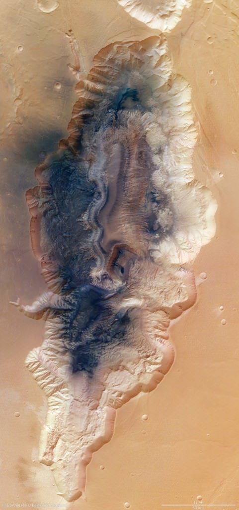
Mosaic of Hebes Chasma by ESA’s Mars Express. Credit: ESA/DLR/FU Berlin (G. Neukum)
Mars Express is a European Space Agency spacecraft and is thus not affected by the shutdown. This mosaic of eight images released Oct. 8 (above) shows Hebes Chasma, which is about 186 miles (300 kilometers) north of Valles Marineris. The trench is about five miles (eight kilometers) deep at its utmost, and hundreds of miles long. “A flat-topped mesa is located in the center of Hebes Chasma, which was likely shaped by the action of wind and water,” ESA wrote.
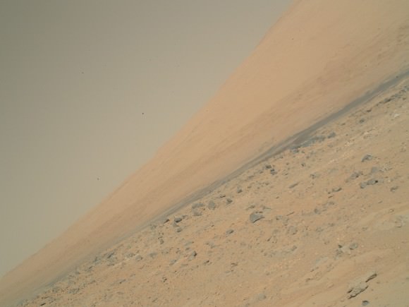
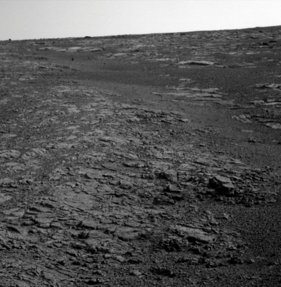
Meanwhile, the Curiosity and Opportunity rovers are still trundling away on Mars. NASA’s Jet Propulsion Laboratory is a contract operation and is still running its missions for the time being. These pictures were downloaded from the raw image sites for the rovers (here and here) as all press updates are suspended amid the shutdown.
Raw Mars Curiosity image on Oct. 3 of Mount Sharp (Aeolis Mons) using its Mars Hand Lens Imager (MAHLI). Credit: NASA/JPL-Caltech/MSSSRaw image of Opportunity’s view of the Martian horizon on Sol 3450 earlier in October. Credit: NASA/JPL-Caltech