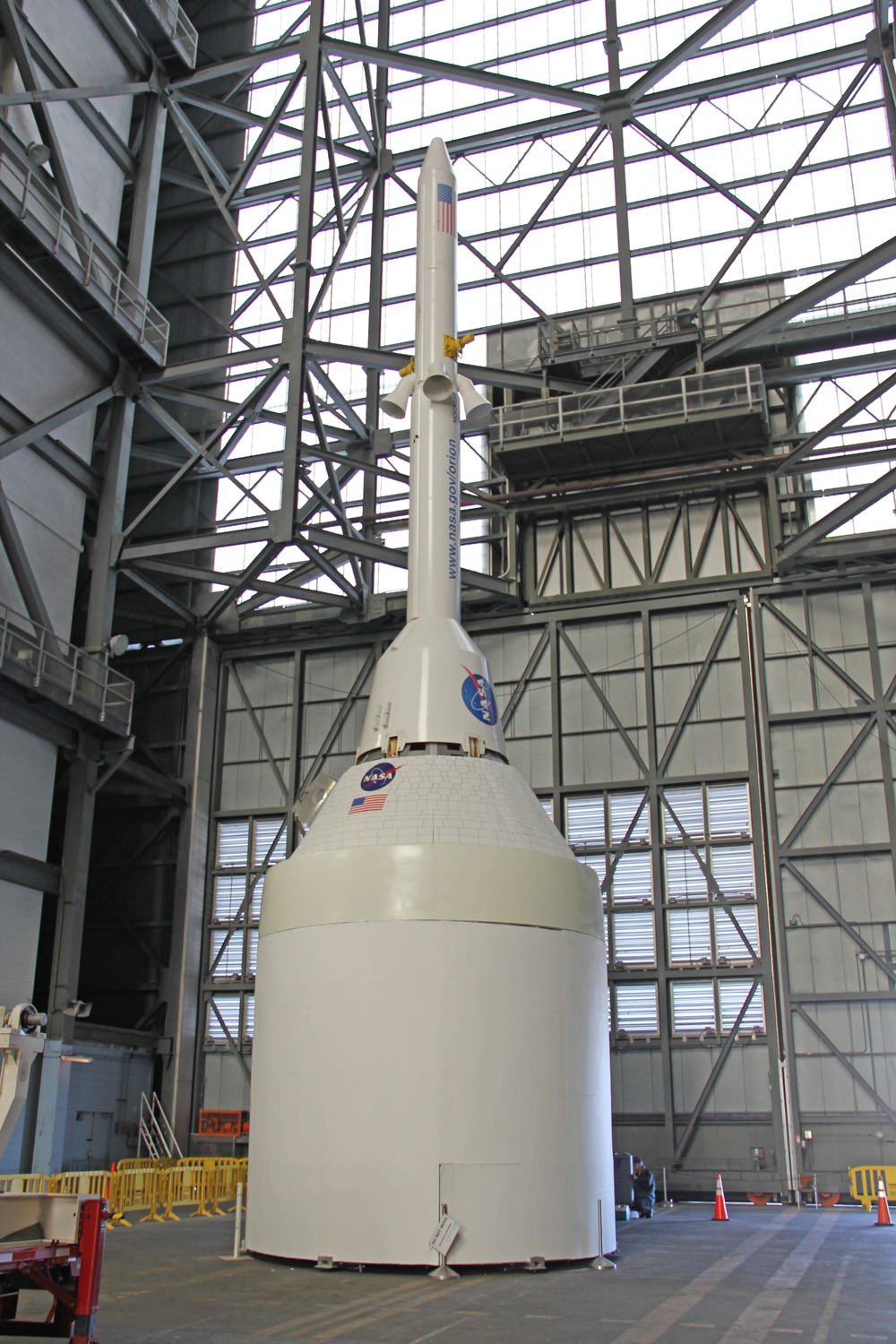
Orion crew capsule, Service Module and 6 ton Launch Abort System (LAS) stack inside the transfer aisle of the Vehicle Assembly Building (VAB) at the Kennedy Space Center (KSC) in Florida. Powerful quartet of LAS abort motors will fire in case of launch emergency to save astronauts lives. Credit: Ken Kremer/kenkremer.com
NASA is testing out the parachutes for the new Orion crew vehicle, and in a first, is broadcasting it live as a Google+ Hangout from the U.S. Army’s Yuma Proving Ground in Arizona. They are also going to make something bad happen, and will be happy if it works! Watch live above (from 10:30 to 11:30 a.m. EDT July 24) or watch the replay later as an Orion test capsule is dropped from a plane at 10,700 meters (35,000 feet) to evaluate its parachutes.
Engineers will simulate a failure of one of the spacecraft’s three main parachutes, releasing it before Orion has landed.
Update: Despite a bad video feed, the test was a success.
“The closer we can get to actual flight conditions, the more confidence we gain in the system,” said Chris Johnson after the test. Johnson is project manager for the Orion capsule parachute assembly system at NASA’s Johnson Space Center in Houston. “What we saw today — other than the failures we put in on purpose — is very similar to what Orion will look like coming back during Exploration Flight Test-1’s Earth entry next year.”
One of three massive main parachutes was cut away early on purpose, and so the spacecraft was left with just two parachutes. However, the capsule still landed safely. Wednesday’s test was the highest-altitude test of a human spacecraft parachute since NASA’s Apollo Program.
During previous tests for Orion’s parachutes, a mock capsule was dropped from a height of 25,000 feet and the parachutes deployed at no higher than 22,000 feet. The extra 10,000 feet of altitude at the beginning of Wednesday’s test made the demonstration the best so far of Orion’s parachute flight and landing.
This test was in preparation for the Exploration Flight Test-1, an uncrewed test of the spacecraft that will send Orion 5,800 km (3,600 miles) away from Earth, scheduled for September 2014. Orion’s parachutes are being tested to ensure they can slow the capsule for a safe landing in the Pacific Ocean as the spacecraft reenters Earth’s atmosphere from deep space missions at speeds of up to 32,000 km/h (20,000 mph.)
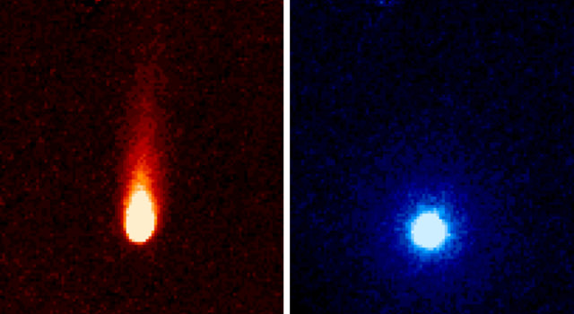
These images from NASA's Spitzer Space Telescope of C/2012 S1 (Comet ISON) were taken on June 13, when ISON was 310 million miles (about 500 million kilometers) from the sun. Image credit: NASA/JPL-Caltech/JHUAPL/UCF
As part of the Comet ISON Observing Campaign, the Spitzer Space Telescope was used to “stare” at the comet for 24 hours on Jun 13, 2013. Images from Spitzer’s “ISON-a-thon” indicate that carbon dioxide and dust are spewing out of the comet at a fairly large rate.
“We estimate ISON is emitting about 2.2 million pounds (1 million kilograms) of what is most likely carbon dioxide gas and about 120 million pounds (54.4 million kilograms) of dust every day,” said Carey Lisse, leader of NASA’s Comet ISON Observation Campaign and a senior research scientist at the Johns Hopkins University Applied Physics Laboratory.
That amount of dust is about the mass of one aircraft carrier every two days or so, tweeted the Sungrazing Comets Twitter feed,, and the amount of carbon dioxide released per day would be enough for about 625 million cans of soda.
The images were taken by the Spitzer’s Infrared Array Camera showing the comet’s tail, which is about 186,400 miles (300,000 kilometers) long.
Comet ISON was about 312 million miles (502 million kilometers) from the Sun, 3.35 times farther than Earth, when the observations were made.
Comet ISON (C/2012 S1) is less than 3 miles (4.8 kilometers) in diameter (about the size of a small mountain) and weighs between 7 billion and 7 trillion pounds (3.2 billion and 3.2 trillion kilograms). However, its true size and density have not yet been accurately determined because of its distance from Earth. Like all comets, ISON is a dirty snowball made up of dust and frozen gases such as water, ammonia, methane and carbon dioxide. These are some of the fundamental building blocks, which scientists believe led to the formation of the planets 4.5 billion years ago.
“This observation gives us a good picture of part of the composition of ISON, and, by extension, of the proto-planetary disk from which the planets were formed,” said Lisse. “Much of the carbon in the comet appears to be locked up in carbon dioxide ice. We will know even more in late July and August, when the comet begins to warm up near the water-ice line outside of the orbit of Mars, and we can detect the most abundant frozen gas, which is water, as it boils away from the comet.”
The comet will pass within 724,000 miles (1.16 million kilometers) of the Sun on Nov. 28.
Astronomers are wondering if the comet will survive its close pass of the Sun, and also if it will live up to expectations of becoming bright enough to be seen in the daytime, as some have predicted.
Only time will tell … and we’ll be here to share the news.
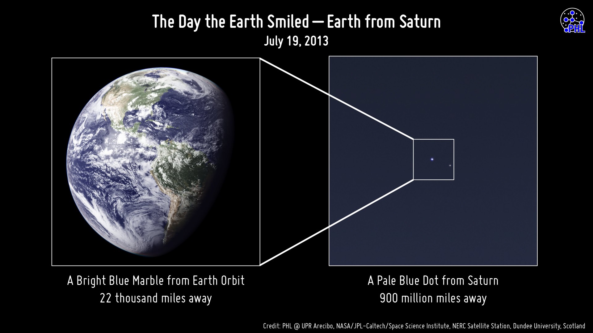
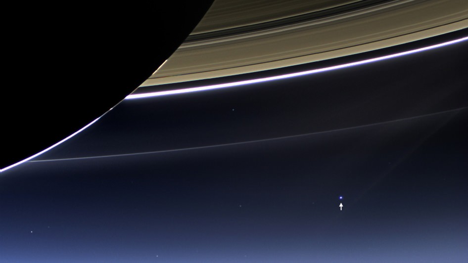
The face of Earth aimed toward Cassini during imaging on July 19, 2013
So along with the rest of the world, you smiled. You waved. You went outside on July 19, wherever you were, and looked upwards and out into the solar system knowing that our robotic representative Cassini would be capturing a few pixels’ worth of photons bouncing off our planet when they eventually reached Saturn, 900 million miles away. But did Cassini actually capture any photons coming from where you were? The image above will tell you.
Assembled by the Planetary Habitability Laboratory at the University of Puerto Rico at Arecibo (where the enormous 305-meter radio telescope is located) this image shows what side of Earth was facing Cassini when its “pale blue dot” images were obtained, at approximately 22:47 UTC (Cassini time.)
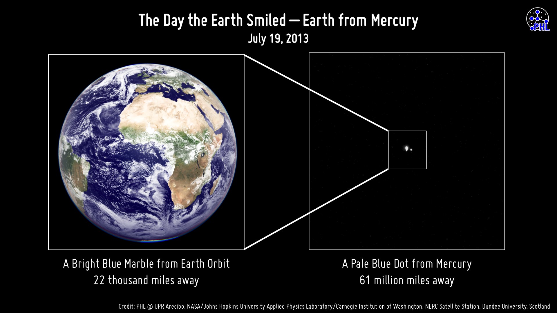
Didn’t make it into Cassini’s photo? That’s ok… maybe MESSENGER had already caught you earlier that very same day:
The view of Earth seen by MESSENGER from Mercury on July 19, 2013
Before Cassini took its images — several hours before, in fact — the MESSENGER spacecraft was holding some photo shoots of its own from 61 million miles in the other direction!
The image above shows the side of Earth that was facing Mercury on the morning of July 19, 2013, when MESSENGER was acquiring images in our direction during a hunt for any possible satellites of the innermost planet.
Earth was as bright (-4.8 magnitude) as the maximum brightness of Venus at the moment the image was taken from Mercury.
Of course, in both series of images specific details of our planet can’t be made out — Earth was barely more than a pixel in size (regardless of any bloom caused by apparent brightness.) Clouds, countries, continents, oceans… the entire population of our world, reduced to a single point of light — a “mote of dust suspended in a sunbeam.”
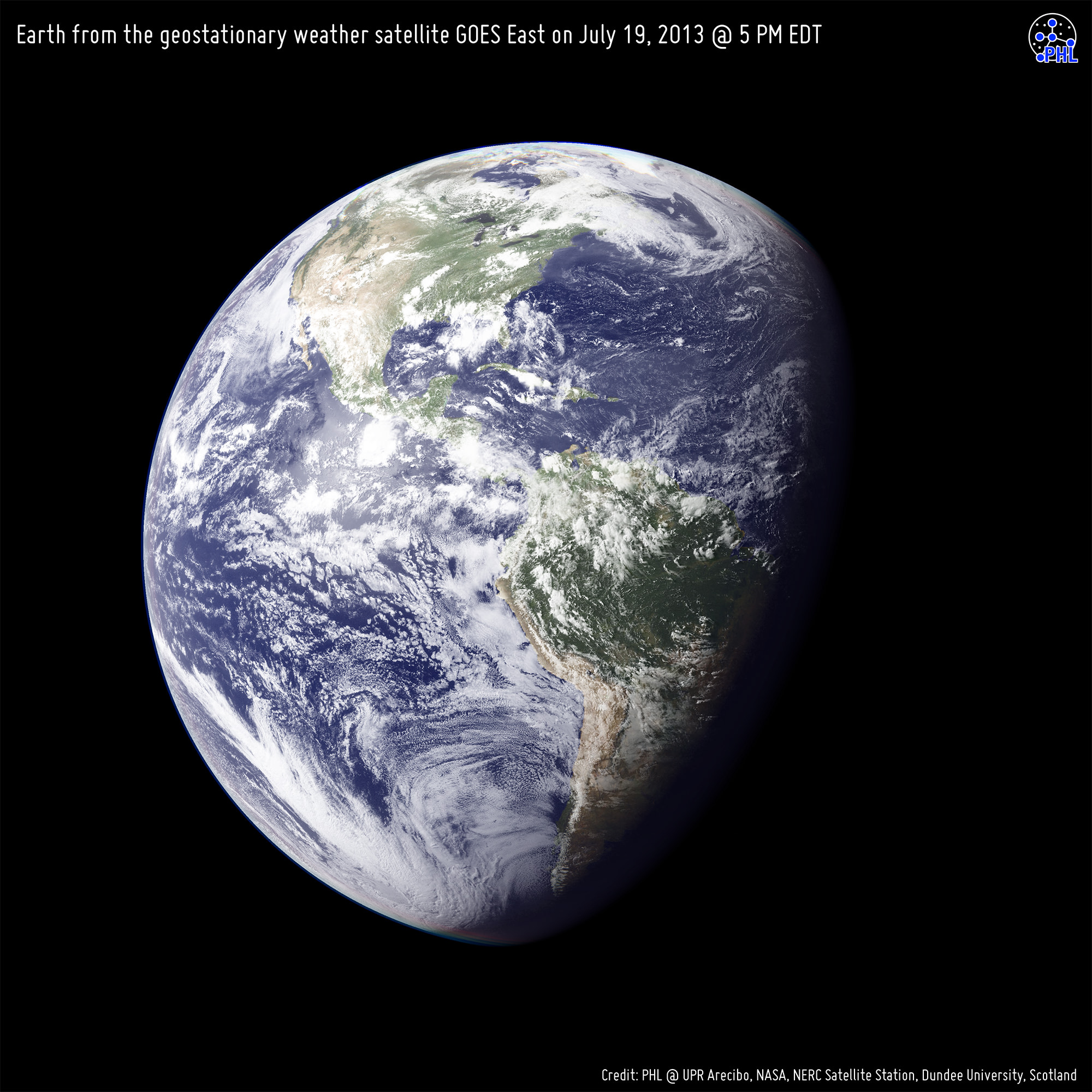
For both portrayals, high-resolution black and white images from the GOES East and Meteosat meteorological satellites were combined with color information from NASA Visible Earth to generate true-color images of our planet as it would have looked to each respective imaging spacecraft… if they had the impossibly-precise optics to resolve Earth from such distances, of course.
But it’s ok that they don’t… we can still use our imaginations.
Earth from the geostationary weather satellite GOES East on July 19, 2013 at 5 PM EST. This is approximately the view that Cassini would have had of Earth during imaging.
Image credits: PHL @ UPR Arecibo, NASA/Johns Hopkins University Applied Physics Laboratory/Carnegie Institution of Washington, NERC Satellite Station, Dundee University, Scotland. Thanks to Prof. Abel Méndez (PHL/UCR) for the heads-up on these.
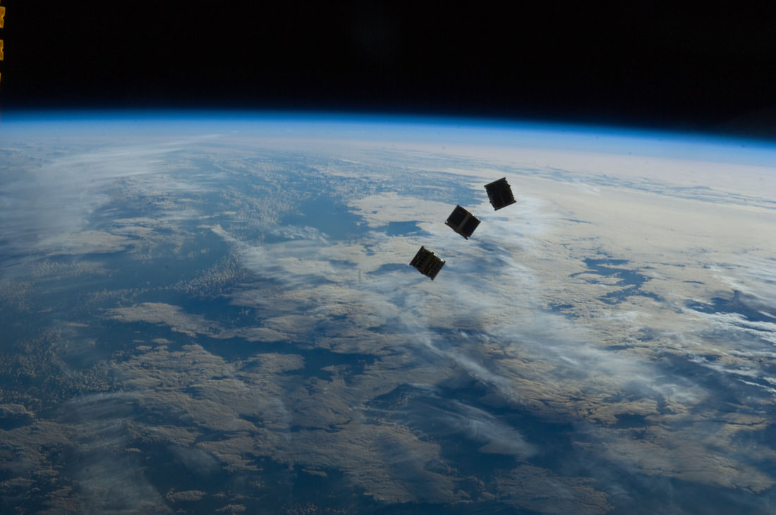
Three small CubeSats are deployed from the International Space Station on October 4, 2012. Credit: NASA
We’ve had several articles recently cubesats — low-cost satellites that seem to be the wave of the future. As technology becomes miniaturized, this allows for inexpensive and quick-to-build satellites. Additionally, they can tag along on launches already scheduled for other things. All this enables students and smaller companies to send equipment and experiments into space.
But the people from DIY Space Exploration say don’t let the small size of a cubesat fool you. The types of missions Cubesats can perform may surprise you and they’re becoming the satellite of choice for anyone looking for a low cost quick response option.
If you visit the DIY Space Exploration website, they have tutorials on how you can put your own cubesat together, and lots of other information. They’ve also put together a great infograhic about what all you can do with a cubesat:
Why do we explore? Is it the desire to break through boundaries, or to probe the perimeters of possibilities? With his lightning-fast mind, self-professed wonder junkie Jason Silva can quickly list all the great quotes about space exploration and why it is important for the human species to explore; and he does it in this new video from his “Shots of Awe” series on You Tube.
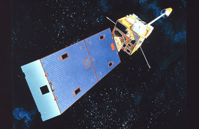
Artist's concept of a GOES spacecraft in orbit. (Credit: NOAA.gov).
It’s sometimes tough being a satellite in Earth orbit these days.
An interesting commentary came our way recently via NASA’s Orbital Debris Program Office’s Orbital Debris Quarterly News. The article, entitled High-Speed Particle Impacts Suspected in Two Spacecraft Anomalies, highlights a growing trend in the local space environment.
The tale begins with GOES 13 located in geostationary orbit over longitude 75° West. Launched on May 24th, 2006 atop a Delta IV rocket, GOES 13 is an integral part of the U.S. National Oceanic and Atmospheric Administration (NOAA’s) Geostationary Operational Environmental Satellite network.
The problems began when GOES-13 began to suffer an “attitude disturbance of unknown origin” on May 22nd of this year, causing it to drift about two degrees per hour off of its required nadir (the opposite of zenith) pointing.
The anomaly was similar to a problem encountered by the NOAA 17 spacecraft on November 20th, 2005. At the time, the anomaly was suspected to be due to a micrometeoroid impact. The Leonid meteors, which peak right around the middle of November, were a chief suspect. However, NOAA 17 suffered a second failure 18 days later, which was later traced down to a hydrazine leak from its errant thrusters.
GOES-13 has weathered hard times before. Back in December of 2006, GOES-13’s Solar X-Ray Imager suffered damage after being struck by a solar flare shortly after initial deployment. GOES-13 also began returning degraded imagery in September 2012, forcing it into backup status for Hurricane Sandy.
GOES-13 was restored to functionality last month. Current thinking is that the satellite was struck by a micrometeorite. No major meteor showers were active at the time.
Loss of a GOES satellite would place a definite strain on our weather monitoring and Earth observing capability. Begun with the launch of GOES-1 in 1975, currently six GOES satellites are in operation, including one used to relay data for PeaceSat (GOES-7) and one used as a communications relay for the South Pole research station (GOES-3).
The GOES program cost NOAA billions in cost overruns to execute. The next GOES launch is GOES-R scheduled in 2015.
But the universe seems to love coincidences.
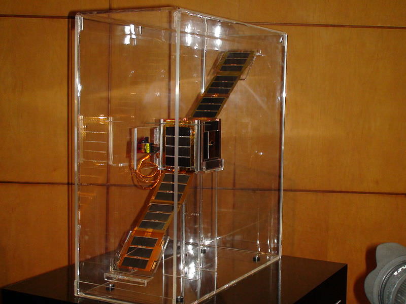
NEE-01 Pegaso before deployment. (Credit: Wikimedia Commons image in the Public Domain).
Less than 26 hours after the GOES 13 anomaly, Ecuador’s first satellite, NEE-01 Pegaso began to have difficulties keeping a stable attitude. The event happened shortly after passage near an old Soviet rocket booster (NORAD designation 1986-058B) which launched Kosmos 1768 on August 2nd, 1986. The U.S. Joint Space Operations Center had warned the fledgling Ecuadorian Space Agency that conjunction was imminent, but of course, there’s not much that could’ve been done to save the tiny CubeSat.
Although the main mass passed Pegaso at a safe distance, current thinking is that the discarded booster may have left a cloud of debris in its wake. Researchers have tracked small “debris clouds” around objects it orbit before- the collision of Iridium 33 and the defunct Kosmos 2251 on February 10th, 2009 left a ring of debris in its wake, and the Chinese anti-satellite test carried out on January 11th, 2007 showered low-Earth orbit with debris for years to come.
The loss represents a blow to Ecuador and their first bid to become a space-faring nation. Launched less than a month prior atop a Long March 2D rocket, Pegaso was a small 10 centimetre nanosatellite equipped with solar panels and dual infrared and visible Earth imaging systems.
A translation from the Ecuadorian Space Agencies site states that;
“The NEE-01 survived the crash and remains in orbit; however it has entered uncontrolled rotation due to the event.
Due to this rotation, (the satellite) cannot point its antenna correctly and stably to the Earth station and although still transmitting and running, the signal cannot be decoded. The Ecuadorian Civilian Space Agency is working tirelessly to stabilize the NEE-01 and recover the use of their signal.
The PEGASUS aired for 7 days your signal to the world via EarthCam, millions could see the Earth seen from space in real time, many for the first time, the files in those 7 days have been published after transmission.”
Ecuador plans to launch another CubeSat, NEE 02 Krysaor later in 2013. A carrier has not yet been named.
While both events suffered by the GOES-13 and NEE-01 Pegaso satellites were unrelated, they underscore problems with space junk and space environmental hazards that are occurring with a higher frequency.
Gabbard diagram displaying a sample disintegration of a Long March 4 booster in 2000. (Credit: the NASA Orbital Debris Office).
Such is the modern hazardous environment of low Earth orbit that new satellites must face. With a growing amount of debris, impact threats are becoming more common. The International Space Station must perform frequent debris avoidance maneuvers to avoid hazards, and more than once, the crew has waited out a pass in their Soyuz escape modules should immediate evacuation become necessary. Punctures from micro-meteoroids or space junk have even been seen recently on the ISS solar panel arrays.
Plans are on the drawing board to deal with space junk, involving everything from “space nets” to lasers and even more exotic ideas. Probably the most immediate solution that can be implemented is to assure new payloads have a way to “self-terminate” via de-orbit at the end of their life span. Solar sail technologies, such as NanoSailD2 launched in 2010 have already demonstrated this capability.
Expect reentries also pick up as we approach the peak of solar cycle #24 at the end of 2013 and the beginning of 2014. Increased solar activity energizes the upper atmosphere and creates increased drag on low Earth satellites.
It’s a brave new world “up there,” and hazards, both natural and man-made, are something that space faring nations will have to come to terms with.
-Read and subscribe to the latest edition of NASA’s Orbital Debris Quarterly News for free here.
Italian astronaut Luca Parmitano during a spacesuit fit check before his mission. Credit: NASA
In the wake of a spacesuit water leak that sent two astronauts back to the airlock early during a spacewalk last week, NASA has convened a board to look at “lessons learned” from the mishap.
The cause of the leak, which filled Luca Parmitano’s helmet with water, is still being investigated. Some media reports say it may have been a fault within the spacesuit’s cooling system. NASA stated it plans to “develop a set of lessons learned from the incident and suggest ways to prevent a similar problem in the future.”
Chairing the board will be Chris Hansen, the International Space Station’s chief engineer at NASA’s Johnson Space Center in Houston. The other four members, who are all from NASA, include:
Mike Foreman, NASA astronaut, Johnson Space Center;
Richard Fullerton, International Space Station safety and mission assurance lead, Office of Safety and Mission Assurance, NASA headquarters;
Sudhakar Rajula, human factors specialist, Johnson Space Center;
Joe Pellicciotti, chief engineer, NASA Engineering and Safety Center, Goddard Space Flight Center.
The July 16 spacewalk stopped early at 1 hour, 32 minutes, far shorter than the crew’s planned 6.5-hour outing. All of the tasks can be easily pushed off to another time, NASA has said. The astronauts were preparing data cables and power for a Russian laboratory module that should reach the station by early 2014, among other tasks.
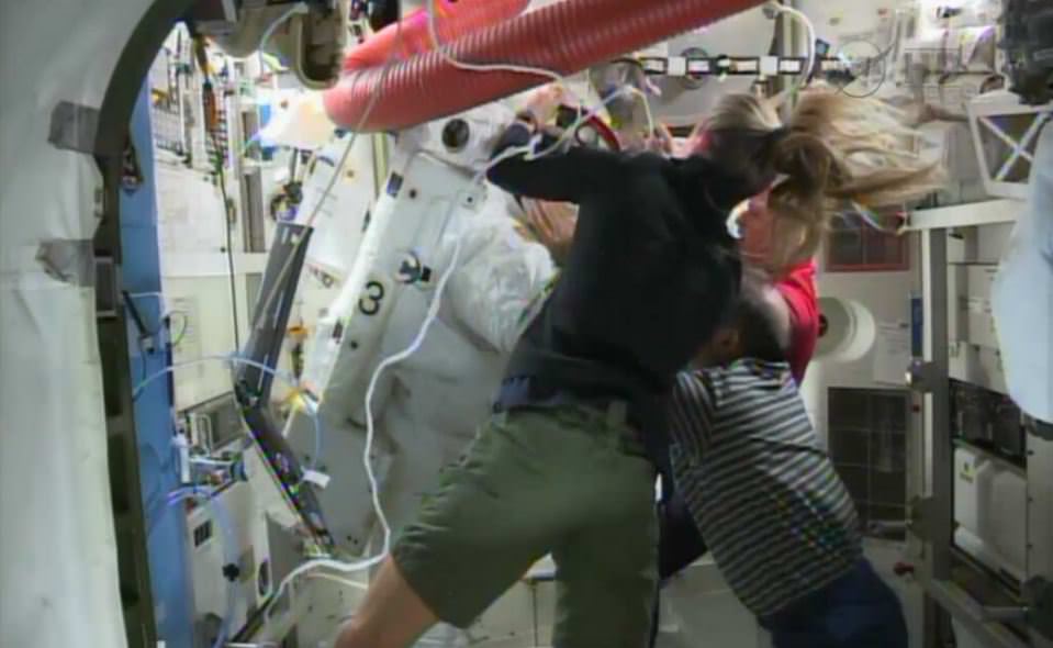
ISS Astronauts had to scramble to get Luca Parmitano out of his spacesuit after water leaked inside the suit, covering his face. Via NASA TV.
During and immediately after the spacewalk, NASA said the crew was in no immediate danger. A few days afterwards, Parmitano reassured officials at the European Space Agency. “Guys, I am doing fine and thanks for all the support. I am really okay and ready to move on,” he said, as reported in an ESA blog post.
Still, there was so much water inside the helmet that after a time, Parmitano had trouble hearing and communicating with his crewmates. “Squeeze my hand if you’re fine,” fellow EVA member Chris Cassidy said to Parmitano during the spacewalk.
NASA also noted there is an engineering analysis happening that is “focused on resolving equipment trouble in an effort to enable U.S. spacewalks to resume.” The board, by contrast, will be looking at aspects such as quality assurance, flight control, operations and maintenance with an eye to improving NASA human spaceflight activities in general.
NASA did not immediately release a date by which it expects the investigation to finish. Meanwhile, at least one news outlet reported that the agency is rushing some spacesuit repair tools on to a Russian Progress supply ship that will leave Kazakhstan for the International Space Station on Saturday.
The Day the Earth Smiled: Sneak Preview. In this rare image taken on July 19, 2013, the wide-angle camera on NASA's Cassini spacecraft has captured Saturn's rings and our planet Earth and its moon in the same frame. Image Credit: NASA/JPL-Caltech/Space Science Institute
The Day the Earth Smiled: Sneak Preview
In this rare image taken on July 19, 2013, the wide-angle camera on NASA’s Cassini spacecraft has captured Saturn’s rings and our planet Earth and its moon in the same frame. Image Credit: NASA/JPL-Caltech/Space Science Institute
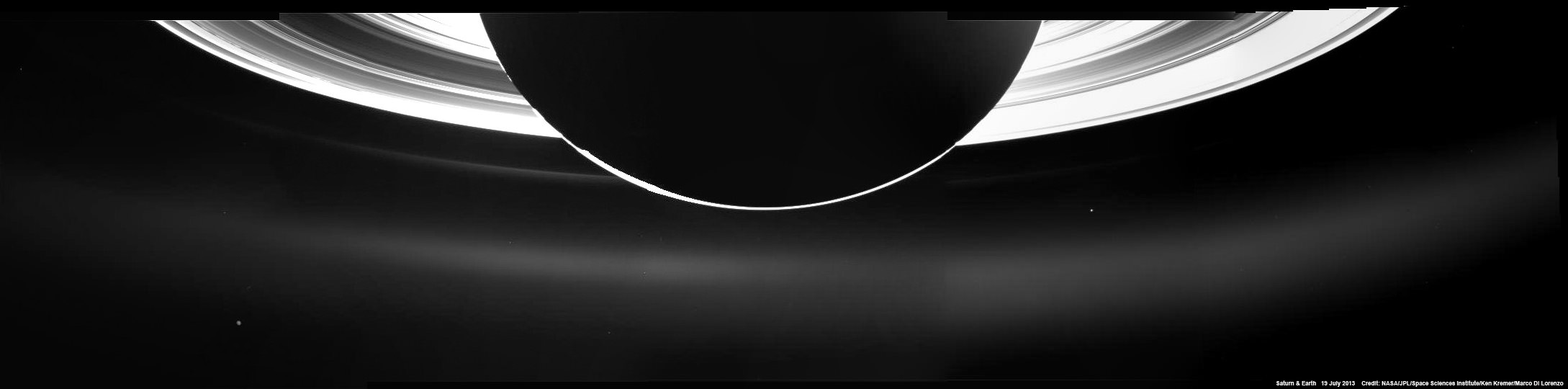
See below our wider context mosaic of the Earth, Saturn and its majestic rings[/caption]
Breathtaking raw images of the Earth and Saturn system snapped by NASA’s Cassini spacecraft on July 19 during the worldwide ‘Wave at Saturn’ campaign are streaming back across 1 billion miles of interplanetary space.
Science team members are now busily processing the images to create individual color composites and a panoramic view of the ‘pale blue dot’ and the entire Saturnian system.
NASA just released the first individual color composite focusing on Earth – see above. And its spectacular!
See below our preliminary mosaic showing the Earth in context with nearly half of Saturn and floating in between its incomparably majestic rings.
Partial context mosaic of the Earth and Saturn taken by NASA’s Cassini orbiter on July 19, 2013. This mosaic was assembled from five wide angle camera raw images and offers a sneak peek of the complete panorama. Credit: NASA/JPL-Caltech/Ken Kremer/Marco Di Lorenzo
To capture all of Saturn and its wide swath of rings, Cassini’s wide angle camera snapped a mosaic of 33 footprints.
“At each footprint, images were taken in different spectral filters for a total of 323 images,” says Carolyn Porco, Cassini Imaging Team leader of the Space Science Institute in Boulder, Colo.
Cassini took the pictures of Earth between 2:27 and 2:42 p.m. PDT on Friday, July 19 from a distance of about 898 million miles (1.44 billion kilometers) away from the home to every human being that has ever lived.
The images show the Earth and the Moon as dots barely about a pixel wide but do reveal the ‘pale blue dot’ that is home to all of humanity and our whitish colored neighbor.
Distant views of the Earth from our robotic explorers, especially from the outer reaches of our Solar System, are few and far between, and are therefore events for space and astronomy enthusiasts and everyone else to savor.
“One of the most exciting Cassini events in 2013 will be the unusual opportunity on July 19 to image the whole Saturn system as it is backlit by the sun,” explained Linda Spilker, Cassini project scientist of NASA’s Jet Propulsion Laboratory, Pasadena, Calif.
“With Saturn covering the harsh light of the sun, we will be gathering unique ring science and also catching a glimpse of our very own home planet.”
Cassini previously took an absolutely fabulous mosaic of Saturn and Earth back in 2006 that stands as one of the landmark images of the space age.
Besides being picturesque, such mosaics also serve science. For example, the 2006 image “revealed that the dusty E ring, which is fed by the water-ice plume of the moon Enceladus, had unexpectedly large variations in brightness and color around its orbit,” says Spilker.
“We’ll want to see how that looks seven Earth years and a Saturnian season later, giving us clues to the forces at work in the Saturn system. We’ll do this analysis by collecting data from our visual and infrared mapping spectrometer, composite infrared mapping spectrometer and ultraviolet imaging spectrograph in addition to the imaging cameras.”
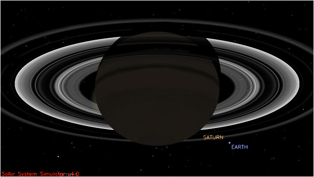
This simulated view from NASA’s Cassini spacecraft shows the expected positions of Saturn and Earth on July 19, 2013, around the time Cassini will take Earth’s picture. Cassini will be about 898 million miles (1.44 billion kilometers) away from Earth at the time. That distance is nearly 10 times the distance from the sun to Earth. Image credit: NASA/JPL-Caltech
“July 19 marked the first time people on Earth had advance notice their planet’s portrait was being taken from interplanetary distances,” says NASA.
I waved fondly at Saturn and hope you had the chance to wave at Saturn from all across the globe. NASA reports that nearly 20,000 participated in organized events. Countless others waved too.
Cassini was launched in 1997 and achieved orbit at Saturn in 2004. The mission is scheduled to continue until 2017 when it will commit a suicide death dive into the gas giant.
“We can’t see individual continents or people in this portrait of Earth, but this pale blue dot is a succinct summary of who we were on July 19,” said Spilker in a NASA statement.
“Cassini’s picture reminds us how tiny our home planet is in the vastness of space, and also testifies to the ingenuity of the citizens of this tiny planet to send a robotic spacecraft so far away from home to study Saturn and take a look-back photo of Earth.”
JPL Waves at Saturn
As NASA’s Cassini spacecraft turned its imaging cameras to Earth, scientists, engineers and visitors at NASA’s Jet Propulsion Laboratory, Pasadena, Calif., gathered to wave at our robotic photographer in the Saturn system on July 19, 2013. Credit: NASA/JPL-Caltech
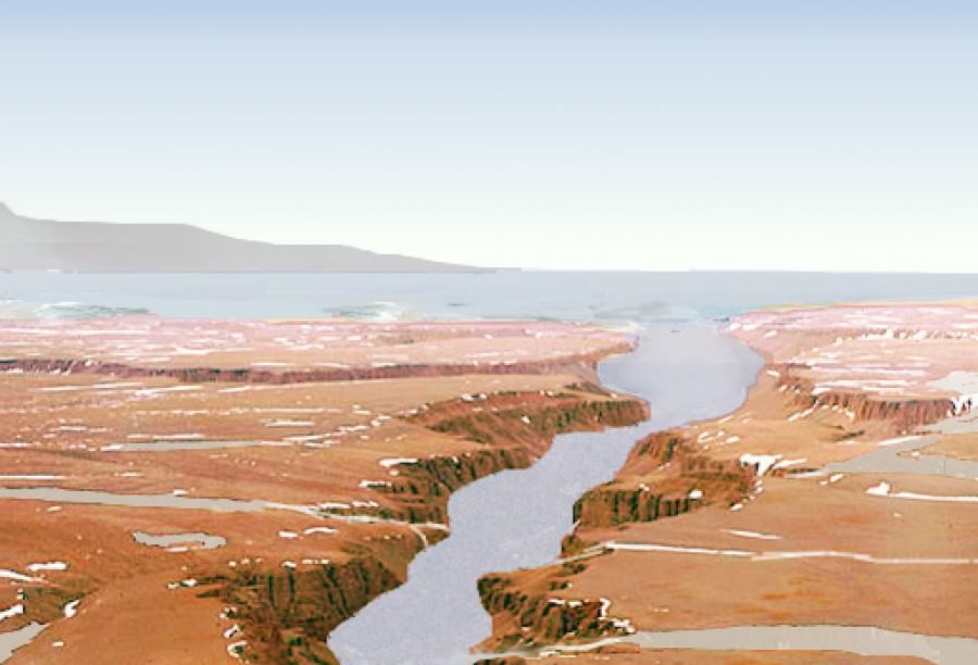
An artist's rendition of what water on Mars may have looked like. Source Credit: NASA
When it comes to Mars, the hot topic of study is water – a prerequisite for life.
While liquid water is currently not stable on the surface of Mars, there is extensive evidence that it may have been in the past. Astronomers have discovered dried up riverbeds, lake deltas, and evidence of widespread glaciers – to name but a few examples.
However, evidence for a massive standing body of water, such as an ocean, is hard to come by. Early climate models struggle to create circumstances under which liquid water would be stable at all. Nonetheless, an ocean spanning the northern lowlands (approximately one third of the planet) has been long hypothesized.
Scientists at Caltech may have just now confirmed this long-held hope in finding recent evidence for a vast Martian ocean.
The region under investigation is known as Aeolis Dorsa – a plain located at the border between the northern lowlands and the southern highlands. This plain contains many ridges, which are interpreted as ancient river channels.
“These ‘inverted’ channels are now elevated because the coarse sand and gravel carried by the channels is more resistant to erosion than the surrounding mud and silt making up the floodplain material,” Dr. Roman DiBiase, lead author on the study, told Universe Today.
Satellite images of Aeolis Dorsa were collected using the HiRISE camera aboard the Mars Reconnaissance Orbiter. The resolution was so precise scientists could distinguish features as small as 25 centimeters – an impressive feat even when compared to images of the Earth.
For certain locations “repeat pictures taken with a slight offset enable the creation of stereo-images from which we can determine the relative elevations of features on the planet’s surface,” explains DiBiase. This impressive technique led to high-resolution topographic models, allowing the team to analyze the geometry and patterns of these inverted channels in unprecedented detail.
Not only do the channels spread out toward the end, they also slope steeply downward, forming a delta – a sedimentary deposit that forms where rivers flow into lakes or oceans.
While deltas have been identified on Mars before, all lie within distinct topographic boundaries, such as an impact crater. This is the most compelling evidence for a delta leading into an unconfined region – an ocean.
Final proof of a Martian ocean will advance our knowledge of the intricate interplay between water, climate, and life. “The history of water on Mars has implications not only for the evolution of Martian climate, but also for learning about the early evolution of Earth and Earth’s climate,” explains DiBiase.
As always, further research is needed. Perhaps in the nearby future the Mars Reconnaissance Orbiter and Curiosity will compliment each other quite well – the orbiter taking images from above while Curiosity plays in the dirt, gathering samples in the riverbed.
The study was published in the Journal of Geophysical Research and may be found here.
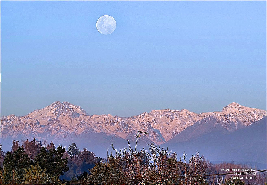
The gibbous Moon rising rising over the Andes Mountains in Chile. (Credit: @WladimirPulgarG/Flickr).
“Once more into the breach, my dear friends…”
Such a quip may be deemed appropriate as we endured the media onslaught this past weekend for the third and final perigee Full Moon of 2013.
Tonight, on Monday, July 22nd, the Moon reaches Full at 18:15 Universal Time (UT)/4:15 PM EDT. This is only 21.9 hours after reaching perigee, or the closest point in its orbit at 358,401 kilometres from the Earth on the Sunday evening at 20:28 UT. Continue reading “Super-Moon Monday: The 3rd (& Final?) Act”