When we heard that the Alan Parsons Project song “Eye in the Sky” was beamed to humanity’s constant eye in the sky — the International Space Station — we just about exploded with space geekiness. It’s even more awesome that the video accompanying the song has tons of space scenes to enjoy.
Turns out the band’s song is Expedition 36 astronaut Luca Parmitano’s favorite, which is why Parsons dedicated that to him during a July 23 Alan Parsons Live Project concert at the Foro Italico in Rome.
Projected vs observed sunspot numbers for solar cycles #23 & #24. (Credit: Hathaway/NASA/MSFC).
Our nearest star has exhibited some schizophrenic behavior thus far for 2013.
By all rights, we should be in the throes of a solar maximum, an 11-year peak where the Sun is at its most active and dappled with sunspots.
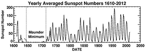
Thus far though, Solar Cycle #24 has been off to a sputtering start, and researchers that attended the meeting of the American Astronomical Society’s Solar Physics Division earlier this month are divided as to why.“Not only is this the smallest cycle we’ve seen in the space age, it’s the smallest cycle in 100 years,” NASA/Marshall Space Flight Center research scientist David Hathaway said during a recent press teleconference conducted by the Marshall Space Flight Center.
Cycle #23 gave way to a profound minimum that saw a spotless Sol on 260 out of 365 days (71%!) in 2009. Then, #Cycle 24 got off to a late start, about a full year overdue — we should have seen a solar maximum in 2012, and now that’s on track for the late 2013 to early 2014 time frame. For solar observers, both amateur, professional and automated, it seems as if the Sun exhibits a “split-personality” this year, displaying its active Cycle #24-self one week, only to sink back into a blank despondency the next.
This new cycle has also been asymmetrical as well. One hallmark heralding the start of a new cycle is the appearance of sunspots at higher solar latitudes on the disk of the Sun. These move progressively toward the Sun’s equatorial regions as the cycle progresses, and can be mapped out in what’s known as a Spörer’s Law.
The sunspot number “butterfly” graph, illustrating Spörer’s Law that susnpots gradually migrate towards the equator of the Sun as the solar cycle progresses. (Credit: NASA/MSFC).
But the northern hemisphere of the Sun has been much more active since 2006, with the southern hemisphere experiencing a lag in activity. “Usually this asymmetry lasts a year or so, and then the hemispheres synchronize,” said Giuliana de Toma of the High Altitude Observatory.
So far, several theories have been put forth as to why our tempestuous star seems to be straying from its usual self. Along with the standard 11-year cycle, it’s thought that there may be a longer, 100 year trend of activity and subsidence known as the Gleissberg Cycle.
The Sun is a giant ball of gas, rotating faster (25 days) at the equator than at the poles, which rotate once every 34.5 days. This dissonance sets up a massive amount of torsion, causing the magnetic field lines to stretch and snap, releasing massive amounts of energy. The Sun also changes polarity with every sunspot cycle, another indication that a new cycle is underway.
But predictions have run the gamut for Cycle #24. Recently, solar scientists have projected a twin peaked solar maximum for later this year, and thus far, Sol seems to be following this modified trend. Initial predictions by scientists at the start of Cycle #24 was for the sunspot number to have reached 90 by August 2013; but here it is the end of July, and we’re sitting at 68, and it seems that we’ll round out the northern hemisphere Summer at a sunspot number of 70 or so.
Some researchers predict that the following sunspot Cycle #25 may even be absent all together.
“If this trend continues, there will be almost no spots in Cycle 25,” Noted Matthew Penn of the National Solar Observatory, hinting that we may be on the edge of another Maunder Minimum.
Looking back over solar cycles for the past 500 years. (Credit: D. Hathaway/NASA/MSFC).
The Maunder Minimum was a period from 1645 to 1715 where almost no sunspots were seen. This span of time corresponded to a medieval period known as the Little Ice Age. During this era, the Thames River in London froze, making Christmas “Frost Fairs” possible on the ice covered river. Several villages in the Swiss Alps were also consumed by encroaching glaciers, and the Viking colony established in Greenland perished. The name for the period comes from Edward Maunder, who first noted the minimum in papers published in the 1890s. The term came into modern vogue after John Eddy published a paper on the subject in the journal of Science in 1976. Keep in mind, the data from the period covered by the Maunder Minimum is far from complete— Galileo had only started sketching sunspots via projection only a few decades prior to the start of the Maunder Minimum. But tellingly, there was a span of time in the early 18th century when many researchers supposed that sunspots were a myth! They were really THAT infrequent…
Just what role a pause in the solar cycle might play in the climate change debate remains to be seen. Perhaps, humanity is getting a brief (and lucky) reprieve, a chance to get serious about controlling our own destiny and doing something about anthropogenic climate-forcing. On a more ominous note, however, an extended cooling phase may give us reason to stall on preparing for the inevitable while giving ammunition to deniers, who like to cite natural trends exclusively.
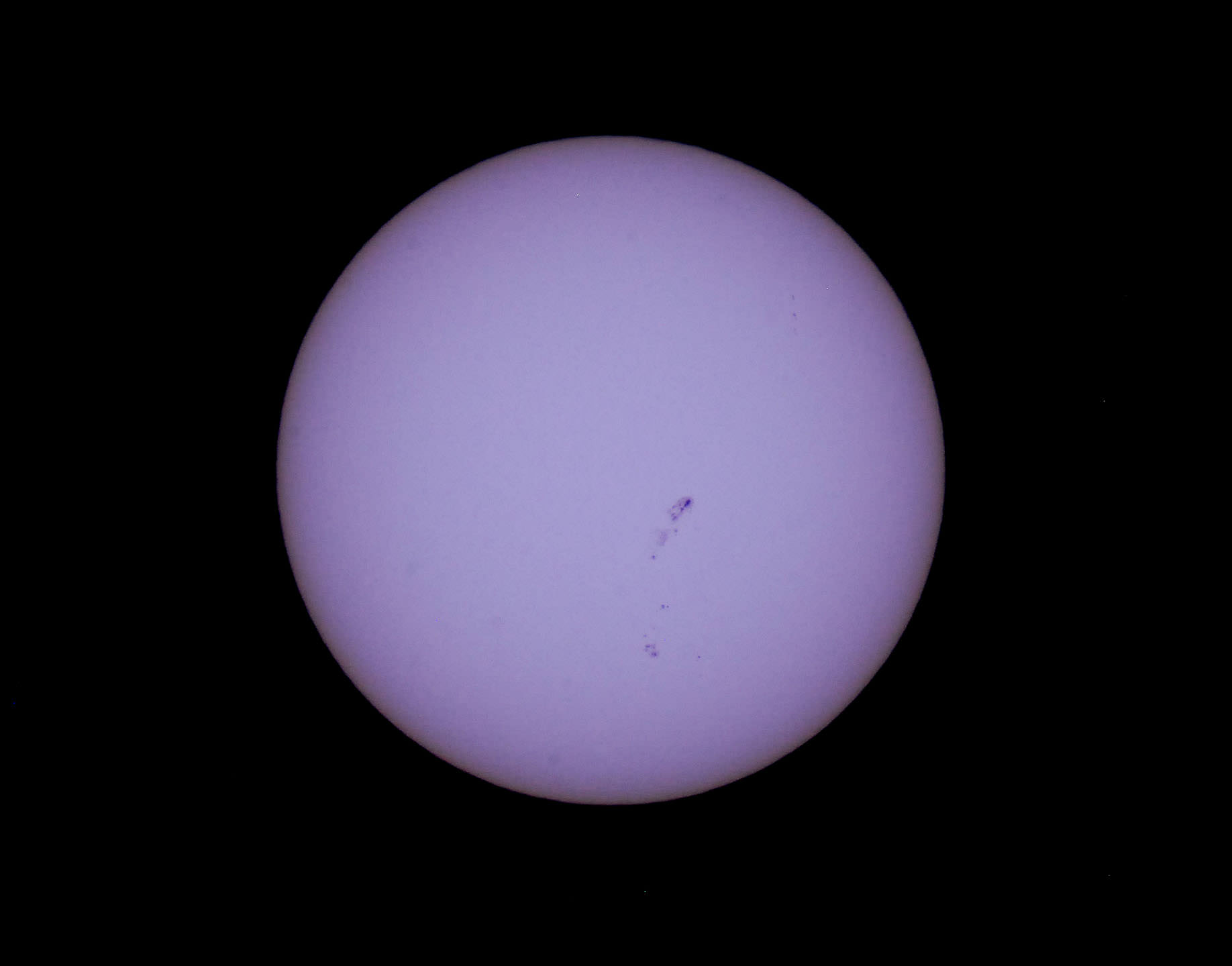
Down but not out? Sol looking more like its solar max-self earlier this month on July 8th. (Photo by author).
Whatever occurs, we now have an unprecedented fleet of solar monitoring spacecraft on hand to watch the solar drama unfold. STEREO A & B afford us a 360 degree view of the Sun. SOHO has now monitored the Sun for the equivalent of more than one solar cycle, and NASA’s Solar Dynamics Observatory has joined it in its scrutiny. NASA’s Interface Region Imaging Spectrograph (IRIS) just launched earlier this year, and has already begun returning views of the solar atmosphere in unprecedented detail. Even spacecraft such as MESSENGER orbiting Mercury can give us vital data from other vantage points in the solar system.
Cycle #24 may be a lackluster performer, but I’ll bet the Sun has a few surprises in store. You can always get a freak cloud burst, even in the middle of a drought. Plus, we’re headed towards northern hemisphere Fall, a time when aurora activity traditionally picks up.
Be sure to keep a (safely filtered) eye on ol’ Sol— it may be the case over these next few years that “no news is big news!”
China's now-industrialized Pearl River Delta, seen in October 1973 (top) and January 2003 (bottom)
Since the launch of its first satellite in 1972, the eight NASA/USGS Landsat satellites have made the longest continuous observations of Earth’s surface, providing invaluable data for research in agriculture, geology, forestry, regional planning, education, mapping, global change research, as well as important emergency response and disaster relief information. In addition, having such a long span of data allows us to easily see the expansion of human development in many areas — unprecedented before-and-after views of city growth seen from space.
These images, taken over the course of the Landsat program, illustrate the visible impact of over three decades of human development:
Chandler, Arizona imaged in 1985 (top) and 2011 (bottom.) As its economy shifted from agriculture to manufacturing and electronics, Chandler’s population multiplied 8 times to over 236,000.The explosion of Istanbul’s population from 2 to 13 million people is evident in these Landsat images, comparing 1975 to 2011. Vegetation appears red in the imaging wavelengths used here.A few years ago one of the fastest-growing cities in the US, Las Vegas is seen here in images taken in 1984 (top) and 2011 (bottom.) The sprawling development — as well as the decrease in water level of Lake Mead — is evident.Some of the most dramatic — and rapid — changes have occurred in Dubai, whose palm- and continent-shaped artificial islands suddenly appear between images taken in 2000 (top) and 2010 (bottom.) Once barely visible against the desert landscape, Dubai is now an international center of business, tourism, and oil production.
The Landsat Program is a series of Earth-observing satellite missions jointly managed by NASA and the U.S. Geological Survey. In 1972, the launch of ERTS-1 (Earth Resources Technology Satellite, later renamed Landsat 1) started the era of a series of satellites that have since continuously acquired space-based land remote sensing data.
The latest satellite in the Landsat series, the Landsat Data Continuity Mission (LDCM) — now named Landsat 8 — was launched on February 11, 2013. Landsat 8 data is now available free to the public online here.
Shhhh, shhh. You can stop screaming. That’s because nobody can hear you … in space. But why not? How does sound work here on Earth, and what would it sound like on other planets?
And the podcast is also available as a video, as Fraser and Pamela now record Astronomy Cast as part of a Google+ Hangout (usually recorded every Monday at 3 pm Eastern Time):
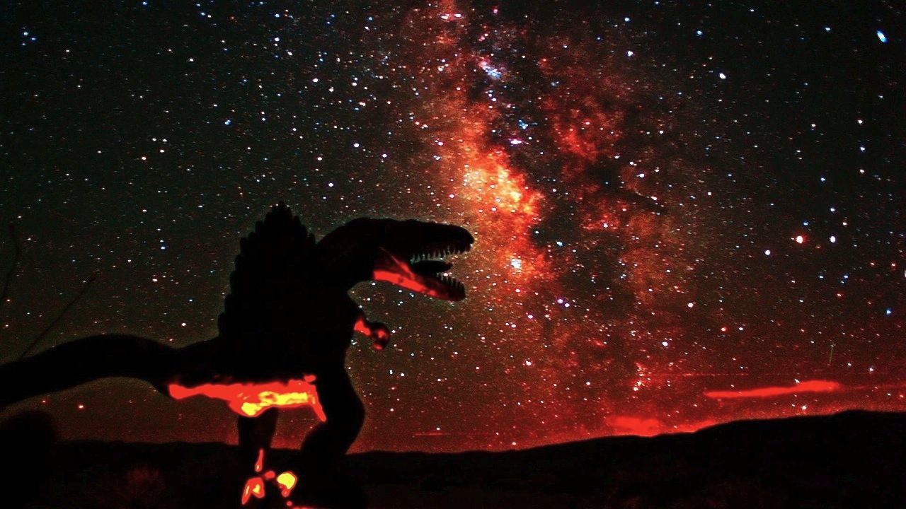
A still from the new timelapse, 'Borrego Stardance' by Gavin Heffernan/Sunchaser Pictures.
Just outside of Borrego Springs, California, monsters lurk. Life-size metal statues of dinosaurs, dragons, and wooly mammoths stand among giant insects, birds and several other creatures. But the 600,000 acre Anzo-Borrego State Park is also an astronomer’s dream, since it is one of four communities in the world to be classified a “Dark Sky Community” by the International Dark Sky Association.
Timelapse maven Gavin Heffernan from Sunchaser Pictures has now combined these monsters and the beautiful dark sky for his latest astronomical timelapse video, Borrego Stardance. It’s an unusual and fanciful look at the night sky –- where else can you see dragons and star trails at the same time? Watch below — and crank the volume for added effect!
“Despite the grueling 112 degree temperatures, my team and I had an amazing shoot, with some of the clearest Milky Way footage we’ve ever captured” Gavin wrote Universe Today via email, “as well as some exciting creature-filled star trails, and more experiments with “Starscaping” (switching from stars to trails mid-shot).”
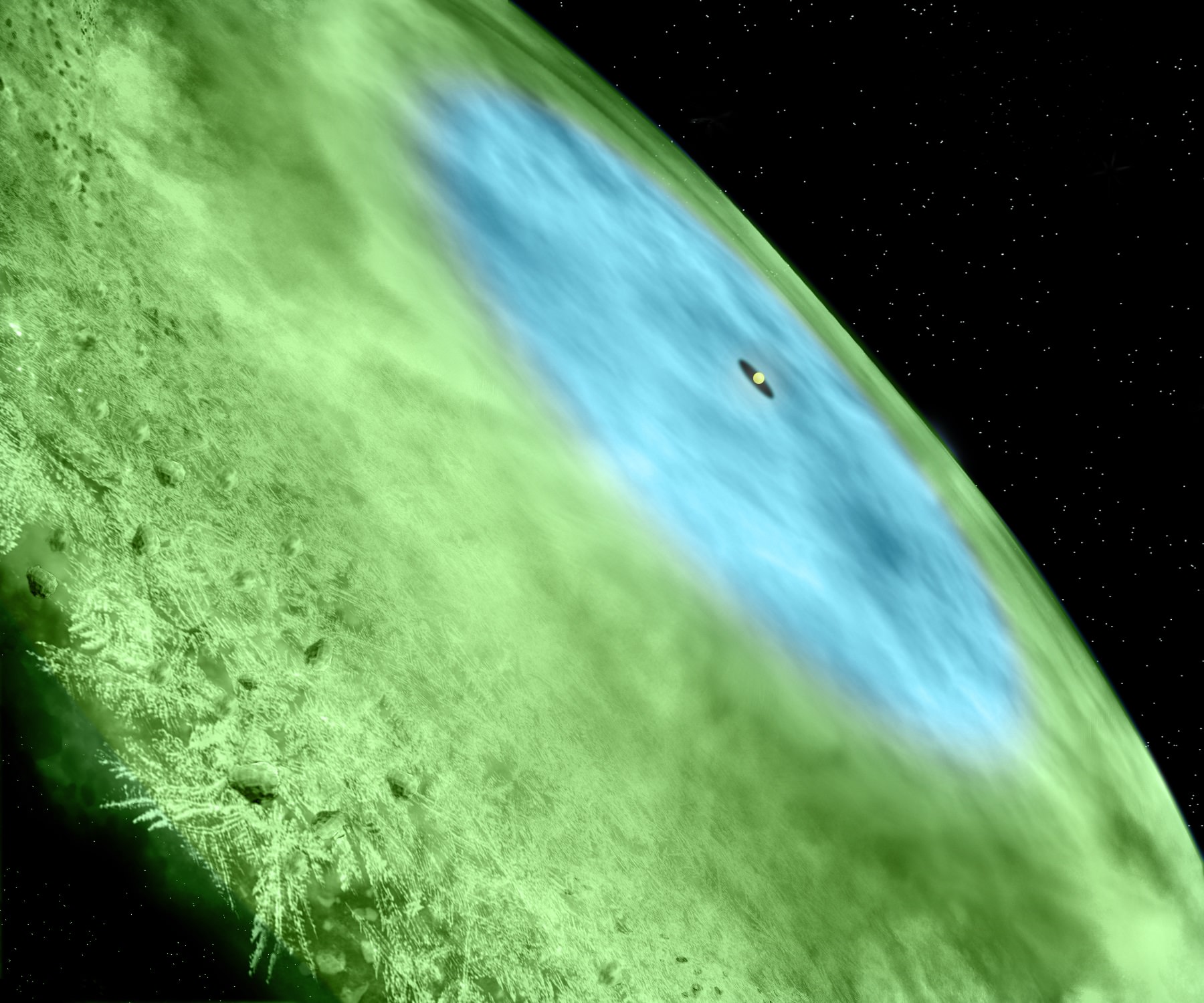
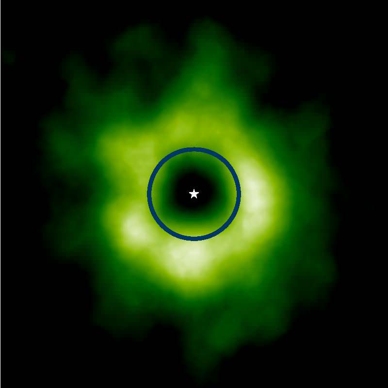
Artist's conception of the snow line in TW Hydrae. Credit: Bill Saxton/Alexandra Angelich, NRAO/AUI/NSF
There’s an excellent chance of frost in this corner of the universe: astronomers have spotted a “snow line” in a baby solar system about 175 light-years away from Earth. The find is cool (literally and figuratively) in itself. More importantly, however, it could give us clues about how our own planet formed billions of years ago.
“[This] is extremely exciting because of what it tells us about the very early period in the history of our own solar system,” stated Chunhua Qi, a researcher with the Harvard-Smithsonian Center for Astrophysics who led the research.
“We can now see previously hidden details about the frozen outer reaches of another solar system, one that has much in common with our own when it was less than 10 million years old,” he added.
The real deal enhanced-color picture of TW Hydrae is below, courtesy of a newly completed telescope: the Atacama Large Millimeter/submillimeter Array in Chile. It is designed to look at grains and other debris around forming solar systems. This snow line is huge, stretching far beyond the equivalent orbit of Neptune in our own solar system. See the circle? That’s Neptune’s orbit. The green stuff is the snow line. Look just how far the green goes past the orbit.
The carbon monoxide line on TW Hydrae as seen by the Atacama Large Millimeter/submillimeter Array (ALMA) telescope. The circle represents the equivalent orbit of Neptune when comparing it to our own solar system. Credit: Karin Oberg, Harvard University/University of Virginia
Young stars are typically surrounded by a cloud of gas and debris that, astronomers believe, can in many cases form into planets given enough time. Snow lines form in young solar systems in areas where the heat of the star isn’t enough to melt the substance. Water is the first substance to freeze around dust grains, followed by carbon dioxide, methane and carbon monoxide.
It’s hard to spot them: “Snow lines form exclusively in the relatively narrow central plane of a protoplanetary disk. Above and below this region, stellar radiation keeps the gases warm, preventing them from forming ice,” the astronomers stated. In areas where dust and gas are more dense, the substances are insulated and can freeze — but it’s difficult to see the snow through the gas.
In this case, astronomers were able to spot the carbon monoxide snow because they looked for diazenylium, a molecule that is broken up in areas of carbon monoxide gas. Spotting it is a “proxy” for spots where the CO froze out, the astronomers said.
Here are some more of the many reasons this is exciting to astronomers:
Snow could help dust grains form faster into rocks and eventually, planets because it coats the grain surface into something more stickable;
Carbon monoxide is a requirement to create methanol, considered a building block of complex molecules and life;
The snow was actually spotted with only a small portion of ALMA’s 66 antennas while it was still under construction. Now that ALMA is complete, scientists are already eager to see what the telescope will turn up the next time it gazes at the system.
And if you’re interested in looking back, here’s an archive to all the past Carnivals of Space. If you’ve got a space-related blog, you should really join the carnival. Just email an entry to [email protected], and the next host will link to it. It will help get awareness out there about your writing, help you meet others in the space community – and community is what blogging is all about. And if you really want to help out, sign up to be a host. Send an email to the above address.
Trying to explain the topology of the Universe is really complicated… for humans. But it clearly comes naturally to Zogg the Alien from Betelgeuse. In this 10-minute video, the plucky alien vividly describes how we could have a Universe which is flat and finite, but doesn’t have an edge. How we could travel in one direction and return to our starting point, never bumping into the outside of the Universe.
What is the Universe expanding into? Nothing, it’s just expanding.
Dig a little further through Zogg’s YouTube channel, and you’ll see a great collection of explainers on eating, vision; and even esoteric topics like imagination and beauty.
I’d love to see more in this series Zogg… hint, hint.
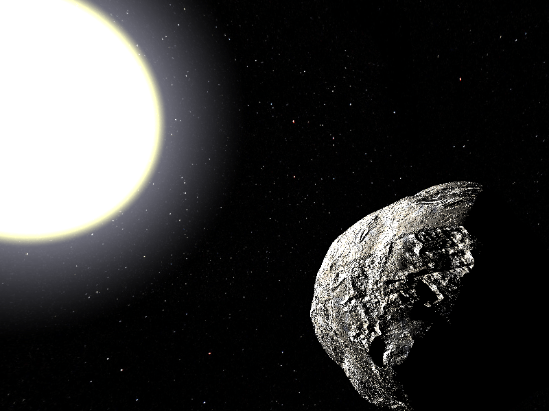
A hypothetical Vulcanoid asteroid in orbit about the Sun. ( Artist's impression in the Public Domain).
One of the most fascinating stories in modern astronomy involves the pursuit of a world that never was.
Tomorrow marks the 135th anniversary of the total solar eclipse of July 29th, 1878. With a maximum totality of 3 minutes 11 seconds, this eclipse traced a path across western Canada and the United States from the territory of Montana to Louisiana.
A curious band of astronomers also lay in wait along the path of totality, searching for an elusive world known as Vulcan.
Long before Star Trek or Mr. Spock, Vulcan was a hypothetical world thought to inhabit the region between the planet Mercury and the Sun.
The tale of Vulcan is the story of the birth of modern predictive astronomy. Vulcan was a reality to 18th century astronomers- it can be seen and the astronomy textbooks and contemporary art and culture of the day. Urbain J.J. Le Verrier proposed the existence of the planet in 1859 to explain the anomalous precession of the perihelion of the planet Mercury. Le Verrier was a voice to be taken seriously — he had performed a similar feat of calculation to lead observers to the discovery of the planet Neptune from the Berlin Observatory on the night of September 23, 1846. Almost overnight, Le Verrier had single-handedly boosted astronomy into the realm of a science with real predictive power.
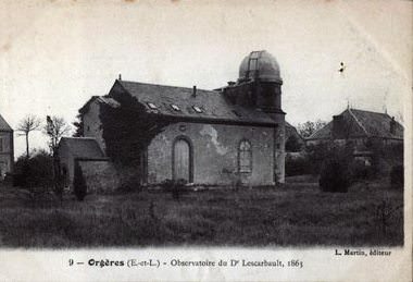
An 1863 photograph of Lescarbault’s country house observatory. (Wikimedia Commons image in the public domain).
The idea of Vulcan gained traction when a French doctor and amateur astronomer Edmond Lescarbault claimed to have seen the tiny world transit the Sun while viewing it through his 95 millimetre refractor on the sunny afternoon of March 26th, 1859. Keep in mind, this was an era when solar observations were carried out via the hazardous method of viewing the Sun through a smoked or oil-filled filter, or the via safer technique of projecting the disk and sketching it onto a piece of paper.
A early right-angle solar viewer from Robert Ariail collection at the South Carolina State Museum in Columbia, South Carolina. Note the vent holes in the back to dissipate heat, and word SUN stenciled on the side! (Photo by author).
A visiting Le Verrier was sufficiently impressed by Lescarbault’s observation, and went as far as to calculate and publish orbital tables for Vulcan. Soon, astronomers everywhere were “seeing dots” pass in front of the Sun. Astronomer F. A. R. Russell spotted an object transiting the Sun from London on January, 29th, 1860. Sightings continued over the decades, including a claim by an observer based near Peckeloh Germany to have witnessed a transit of Vulcan on April 4th, 1876.
Incidentally, we are not immune to this effect of “contagious observations” even today — for example, when Comet Holmes brightened to naked eye visibility in October 2007, spurious reports of other comets brightening flooded message boards, and a similar psychological phenomena occurred after amateur astronomer Anthony Wesley recorded an impact on Jupiter in 2010. Though the event that triggered the initial observation was real, the claims of impacts on other bodies in the solar system that soon followed turned out to be bogus.
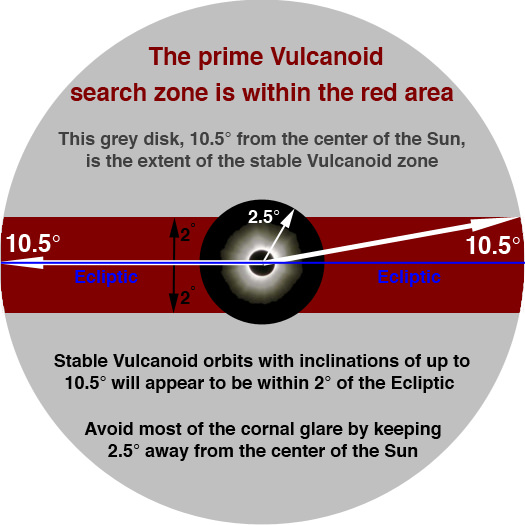
Possible “target zone” for the existence of Vulcan, and later Vulcanoid asteroids. (Graphic in the public domain).
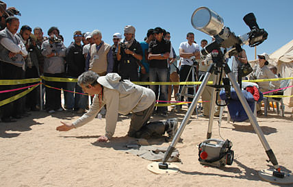
Still, reports of the planet Vulcan were substantial enough for astronomers to mount an expedition to the territory of Wyoming in an attempt to catch dim Vulcan near the Sun during the brief moments of totality. Participants include Simon Newcomb of the Naval Observatory, James Craig Watson and Lewis Swift. Inventor Thomas Edison was also on hand, stationed at Rawlins, Wyoming hoping to test his new-fangled invention known as a tasimeter to measure the heat of the solar corona.
Conditions were austere, to say the least. Although the teams endured dust storms that nearly threatened to cut their expeditions short, the morning of the 29th dawned, as one newspaper reported, “as slick and clean as a Cheyenne free-lunch table.” Totality began just after 4 PM local, as observers near the tiny town of Separation, Wyoming swung their instruments into action.
Such a quest is difficult under the best of circumstances. Observers had to sweep the area within 3 degrees of the Sun (six times the diameter of a Full Moon) quickly during the fleeting moments of totality with their narrow field refractors, looking for a +4th magnitude star or fainter among the established star fields.
Map of the path of the total solar eclipse of July 29th, 1878. (Credit: Fred Espenak/NASA/GSFC).
In the end, the expedition was both a success and a failure. Watson & Swift both claimed to have identified a +5th magnitude object similar in brightness to the nearby star Theta Cancri. Astronomer Christian Heinrich Friedrich Peters later cast doubt on the sighting and the whole Vulcan affair, claiming that “I refuse to go on a wild goose chase after Le Verrier’s mythical birds!”
And speaking of birds, Edison ran into another eclipse phenomenon while testing his device, when chickens, fooled by the approaching false dusk came home to roost at the onset of totality!
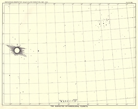
Vulcan search map for the Smithsonian Observatory’s 1900 eclipse expedition. (From the collection of Michael Zeiler@EclipseMaps, used with permission).
But such is the life of an eclipse-chaser. Albert Einstein’s general theory of relativity explained the precession of Mercury’s orbit in 1916 and did away with a need for Vulcan entirely.
But is the idea of intra-Mercurial worldlets down for the count?
The search strategy for NASA’s high-altitude mission to hunt for Vulcanoids in 2002. (Credit: NASA/Dryden).
Amazingly, the quest for objects inside Mercury’s orbit goes on today, and the jury is still out. Dubbed Vulcanoids, modern day hunters still probe the inner solar system for tiny asteroids that may inhabit the region close to the Sun. In 2002, NASA conducted a series of high altitude flights out of the Dryden Flight Research Center at Edwards Air Force Base, California, sweeping the sky near the Sun for Vulcanoids at dawn and dusk. Now, there’s a job to be envious of — an F-18 flying astronomer!
One of NASA’s fleet of high-performance F-18 aircraft. (Credit: NASA).
NASA’s MESSENGER spacecraft was also on the lookout for Vulcanoids on its six year trek through the inner solar system prior to orbital insertion on March 18th, 2011.
Thus far, these hunts have turned up naught. But one of the most fascinating quests is still ongoing and being carried out by veteran eclipse-chaser Landon Curt Noll.
Mr. Noll last conducted a sweep for Vulcanoids during total phases of the long duration total solar eclipse of July 22nd, 2009 across the Far East. He uses a deep sky imaging system, taking pictures in the near-IR to accomplish this search. Using this near-IR imaging technique during a total solar eclipse requires a stable platform, and thus performing this feat at sea or via an airborne platform is out. Such a rig has been successful in catching the extremely thin crescent Moon at the moment it reaches New phase.
Mr. Noll explains the aspects of an eclipse during a 2006 expedition to Libya. (Coutesy of Landon Curt Noll, used with permission).
To date, no convincing Vulcanoid candidates have been found. Mr. Noll also notes that the European Space Agency/NASA’s joint Solar Heliospheric Observatory (SOHO) spacecraft has, for all intents and purposes, eliminated the possibility of Vulcanoids brighter than +8th magnitude near the Sun. Modern searches during eclipses conducted in this fashion scan the sky between wavelengths of 780 to 1100 nanometres down to magnitude +13.5. Mr. Noll told Universe Today that “Our improved orbital models show that objects as small as 50m in diameter could reside in a zone 0.08 A.U. to 0.18 AU (1.2 to 2.7 million kilometers) from the Sun.” He also stated that, “there is plenty of ‘room’ for (Vulcanoids) in the 50 metre to 20 kilometre range.”
The modern day Vulcanoid search strategy. (Diagram courtesy of Landon Curt Noll, used with permission).
Mr. Noll plans to resume his hunt during the August 21st, 2017 total solar eclipse spanning the continental United States. Totality for this eclipse will have a maximum duration of 2 minutes and 40 seconds. Circumstances during the next solar eclipse (a hybrid annular-total crossing central Africa on November 3rd, 2013) will be much more difficult, with a max totality located out to sea of only 1 minute and 40 seconds.
Mr. Noll talks with a local reporter during the 2006 total solar eclipse expedition to Libya. (Photograph courtesy of Landon Curt Noll, used with permission).
Still, we think it’s amazing that the quest for Vulcan (or at least Vulcanoids) is alive and well and being spearheaded by adventurous and innovative amateur astronomers. In the words of Vulcan’s native fictional son, may it “Live Long & Prosper!”
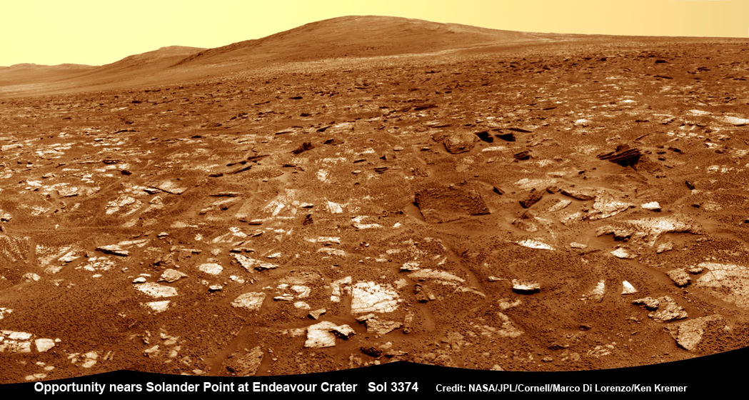
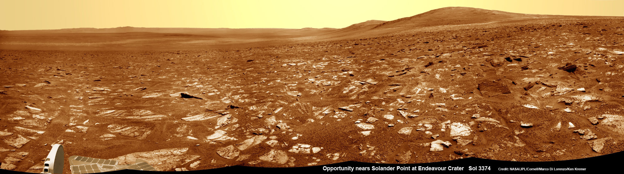
Opportunity rover’s view from very near the foothills of Solander Point looking along the rim and vast expanse of Endeavour Crater. Solander Point is the 1st Martian Mountain NASA’s Opportunity will climb and the rovers next destination. Solander Point may harbor clay minerals indicative of a past Martian habitable environment. This navcam mosaic was assembled from raw images taken on Sol 3374 (July 21, 2013). Credit: NASA/JPL/Cornell/Marco Di Lorenzo/Ken Kremer (kenkremer.com) See complete panoramic mosaic below
Opportunity rover’s view from very near the foothills of Solander Point looking along the rim and vast expanse of Endeavour Crater. This area exhibits gypsum signatures and numerous blocks of intriguing rock. Solander Point is the 1st Martian Mountain NASA’s Opportunity will climb and the rovers next destination. Solander Point may harbor clay minerals indicative of a past Martian habitable environment. This navcam mosaic was assembled from raw images taken on Sol 3374 (July 21, 2013). Credit: NASA/JPL/Cornell/Marco Di Lorenzo/Ken Kremer (kenkremer.com).
See complete panoramic mosaic below. Story updated with further details[/caption]
Exactly a decade after blasting off for the Red Planet and discovering a wide swath of water altered rocks and minerals in the ensuing years by exploring countless craters large and small, NASA’s intrepid Opportunity rover is just days away from arriving at her next big quest – a Martian mountain named Solander Point that may possess the key chemical ingredients necessary to sustain Martian life forms.
“We are parked 200 meters away from the bench at Solander Point,” Ray Arvidson told Universe Today exclusively. Arvidson is the mission’s deputy principal scientific investigator from Washington University in St. Louis, Mo. Furthermore, this area exhibits signatures related to water flow.
Solander Point also represents ‘something completely different’ – the first mountain the intrepid robot will ever climb.
“This will be Opportunity’s first mountain and the view from the ridge crest should be spectacular,” wrote Larry Crumpler, a science team member from the New Mexico Museum of Natural History & Science, in his latest field report about the 10 years ongoing Mars Exploration Rover (MER) mission.
Indeed the rover is now just a few short drives southward from making landfall on the northern tip of the point in her current trek across the relatively flat plains around the rim of Endeavour crater.
“We are now only about 180 meters from the new mountain, Solander Point.”
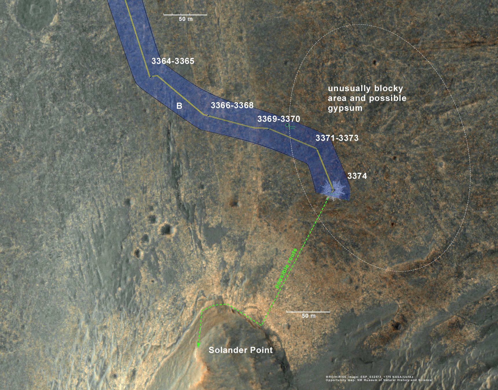
Opportunity rover location in the latest MRO/HiRISE color image. The green line shows more or less the route we hope to take to the base of Solander point. Since it is only a couple of hundred meters away, the rover could be there is a couple of drives. Maybe by the end of next week. The label say “3374” but this is also roughly the location through 3379. NASA/JPL/Larry Crumpler
But before moving onward, Arvidson explained that the rover will briefly pause here “at dark terrain” for some exciting science due to water related spectral observations from the CRISM instrument captured by NASA’s Mars Reconnaissance Orbiter (MRO) circling overhead.
“CRISM data [from Mars orbit] shows a relatively deep 1.9 micrometer absorption feature due to H2O-bearing minerals,” said Arvidson.
This past spring, Opportunity made the historic discovery of clay minerals and a habitable environment on a low hill called Cape York at the rover’s prior stop along the rim of Endeavour crater.
Solander was selected as the robot’s next destination because it simultaneously offers a goldmine of science as well as north facing slopes – where Opportunity’s solar wings can more effectively soak up the sun’s rays to generate life giving electrical power during the next Martian winter.
But since Opportunity is currently generating plenty of power from her solar arrays and arriving with a bonus cushion of time before the looming onset of her 6th Martian winter, the team decided to take a small detour to the southeast and spend several sols (or Martian days) exploring an area of intriguing geology of outcrops, gypsum signatures and more on the bench surrounding the base of the mountain.
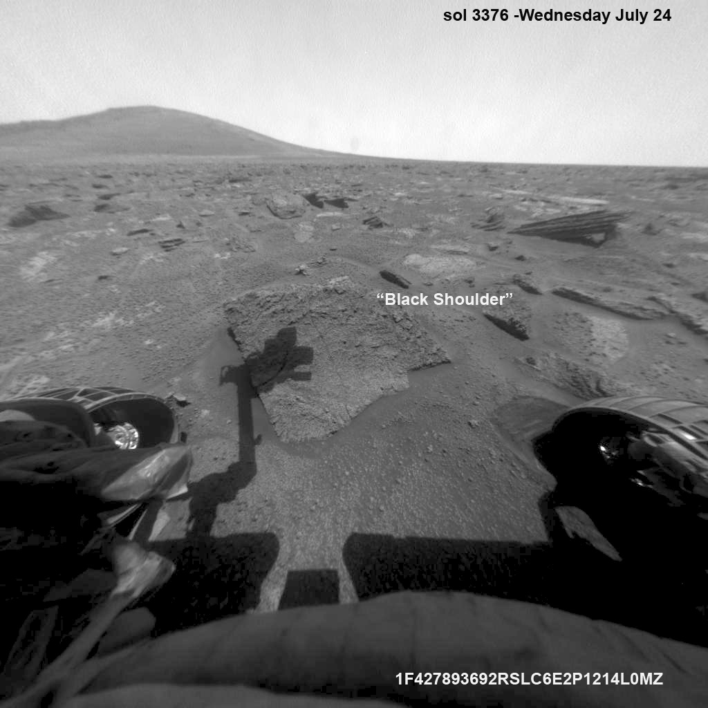
“We slowed down this week so that we could check out the rocks here where there is a strange hydration signature from orbital remote sensing,” says Crumpler.
“This is also an area that appears to have more large blocks in the HiRISE images [from Mars orbit], so we are checking out one of the blocks, “Black Shoulder”.
“We are hoping that the rocks on the ridge crest will be spectacular too,” notes Crumpler.
Opportunity rover’s view very near the foothills of Solander Point along the rim and vast expanse of Endeavour Crater. This area exhibits gypsum signatures and numerous blocks of intriguing rock. Solander Point is the 1st Martian Mountain NASA’s Opportunity will climb and the rovers next destination. Solander Point may harbor clay minerals indicative of a past Martian habitable environment. This navcam panoramic mosaic was assembled from raw images taken on Sol 3374 (July 21, 2013). Credit: NASA/JPL/Cornell/Marco Di Lorenzo/Ken Kremer (kenkremer.com)
Opportunity is using the science instruments on her 3 foot ( 1 meter) long robotic arm to conduct brief in-situ investigations of “Black Shoulder” with the Microscopic Imager (MI) and the Alpha Particle X-ray Spectrometer (APXS).
And …. it’s ‘Mountains Galore’ from here on out for the remainder of Opportunity’s Magnificent Mission to Mars.
Why? Because Opportunity is nearing the foothills of a long chain of eroded segments of the crater wall of Endeavour crater which spans a humongous 14 miles (22 kilometers) wide.
Solander Point may harbor deposits of phyllosilicate clay minerals – which form in neutral pH water – in a thick layer of rock stacks indicative of a past Martian habitable zone.
The rover team is discussing the best way to approach and drive up Solander.
“One idea is to drive part way up Solander from the west side of the rim, turn left and then drive down the steeper north facing slopes with the stratographic sections,” Ray Arvidson explained to Universe Today.
“That way we don’t have to drive up the relatively steeper slopes.”
“The rover can drive up rocky surfaces inclined about 12 to 15 degrees.”
“We want to go through the stratographic sections on the north facing sections,” Arvidson told me.
Opportunity rover moves closer to the foothills of Solander Point along the rim and vast expanse of Endeavour Crater. The rover investigated one of the large rocks near here with her microscopic imager and X-Ray spectrometer. Soon she will start climbing up Solander – her 1st Martian Mountain ascent. This navcam panoramic mosaic was assembled from raw images taken on Sol 3376 (July 23, 2013).
Credit: NASA/JPL/Cornell/Marco Di Lorenzo/Ken Kremer (kenkremer.com)
Today (July 28) is Sol 3380 for a mission that was only warrantied to last 90 Sols!
Opportunity’s total driving distance exceeds 23.6 miles (37.9 kilometers). She has snapped over 182,000 images.
The “work volume”. This view from the front hazcams shows the rock target that is being checked out before the final slog to the south. With luck, by the end of next week we will be plinking around the base of yonder mountain. “Plinking” is a geological term for wandering around with your hammer trying to get a handle on the local outcrops before plunging ahead with mapping and asking the rocks serious questions. Credit: NASA/JPL/Larry Crumpler
Meanwhile on the opposite side of Mars at Gale Crater, Opportunity’s younger sister rover Curiosity also discovered a habitable environment originating from a time when the Red Planet was far warmer and wetter billions of years ago.
And like Opportunity, Curiosity is also trekking towards a mountain rich in sedimentary layers hoping to unveil the mysteries of Mars past. But Curiosity likely won’t arrive at 3.4 mile (5.5 km) high Mount Sharp for another year.
Traverse Map for NASA’s Opportunity rover from 2004 to 2013
This map shows the entire path the rover has driven during more than 9 years and over 3374 Sols, or Martian days, since landing inside Eagle Crater on Jan 24, 2004 to current location near foothills of Solander Point at the western rim of Endeavour Crater. Opportunity discovered clay minerals at Esperance – indicative of a habitable zone. Credit: NASA/JPL/Cornell/ASU/Marco Di Lorenzo/Ken Kremer
…………….
Learn more about Mars, Curiosity, Opportunity, LADEE, MAVEN, Antares and more at Ken’s upcoming lecture presentations
Aug 12: “RockSat-X Suborbital Launch, LADEE Lunar & Antares Rocket Launches from Virginia”; Rodeway Inn, Chincoteague, VA, 8 PM