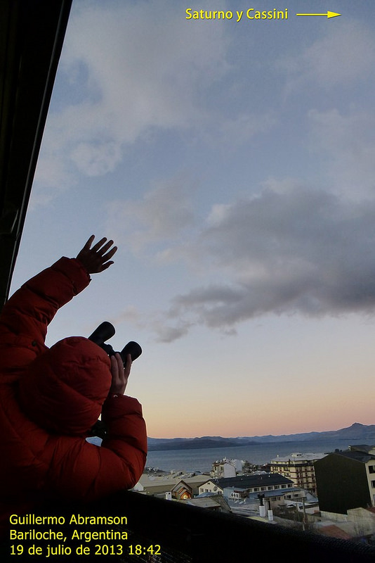
Guillermo Abramson from Argentina takes a picture of himself waving at Saturn on July 19, 2013 during 'The Day the Earth Smiled' event. Credit and copyright: Guillermo Abramson.
For all our astrophotographer friends out there: If you haven’t heard about the Saturn Mosaic Project, you’ll want to take note of this. In cooperation with Astronomers Without Borders, the special project for the recent Cassini image of planet Earth, called The Day The Earth Smiled (TDTES) is sponsoring a Saturn Mosaic project, where you can submit an image you’ve taken of Saturn. Those received will be compiled into a mosaic that will look like image that Cassini took on July 19, showing Earth just below Saturn’s rings (see below). But when you zoom in you’ll see all the pictures from Earth that the mosaic is made of.
I received a note from AWB President Mike Simmons saying they need more submissions, and the deadline for submitting a photo has been extended to July 29, 2013.
“I know a lot more people will want to be a part of this if they know about it,” Mike said via email. “It’s something to tide everyone over and keep the buzz going while we wait for the final mosaic from Cassini.”
But you don’t have to be a seasoned astrophotographer to take part in the Saturn Mosaic. The image you submit doesn’t have to be one taken with a large telescope – just take a picture of Saturn as a “star” in the sky with an ordinary camera, capturing your surroundings as well. Or it could be an image you took earlier this year.
“There are other kinds of photos that anyone can submit that don’t even requiring imaging the sky,” Simmons added. “We didn’t want to limit this to only those with the ability and weather to image Saturn itself. Photos of outreach events or people waving at Saturn from JPL’s Wave at Saturn are good, too. Or just a portrait taken with the Lord of the Rings — a live view projected from a telescope or even a photo. Like a couple getting married at the time Cassini was taking their photo (and everyone else’s) posed with Saturn. I took the easy way and took a shot of me and Saturn in my office.”
These can be taken any time, so people can still take a shot and get into the mosaic (the image does need to have been taken in 2013, however.)
“It’s all about sharing and commemorating the excitement of the moment when the photo was taken, and the anticipation of the release of Cassini’s historic photos,” Simmons said. “Like all Astronomers Without Borders project, it’s open to everyone on Earth. And beyond.”
For a slide show of some of the great shots people have submitted so far, visit the Saturn Mosaic Project page to see things like Saturn with a T-Rex, outreach in Iran, kids drawings of Saturn in Ghana, and more.
Simmons said The World at Night will create the final mosaic, which is expected to be online and ready to view and zoom in on by August 4 or earlier.
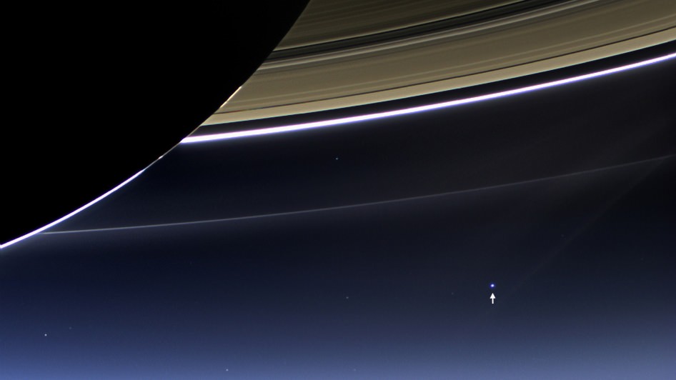
The Day the Earth Smiled: Sneak Preview. In this rare image taken on July 19, 2013, the wide-angle camera on NASA’s Cassini spacecraft has captured Saturn’s rings and our planet Earth and its moon in the same frame. Image Credit: NASA/JPL-Caltech/Space Science Institute
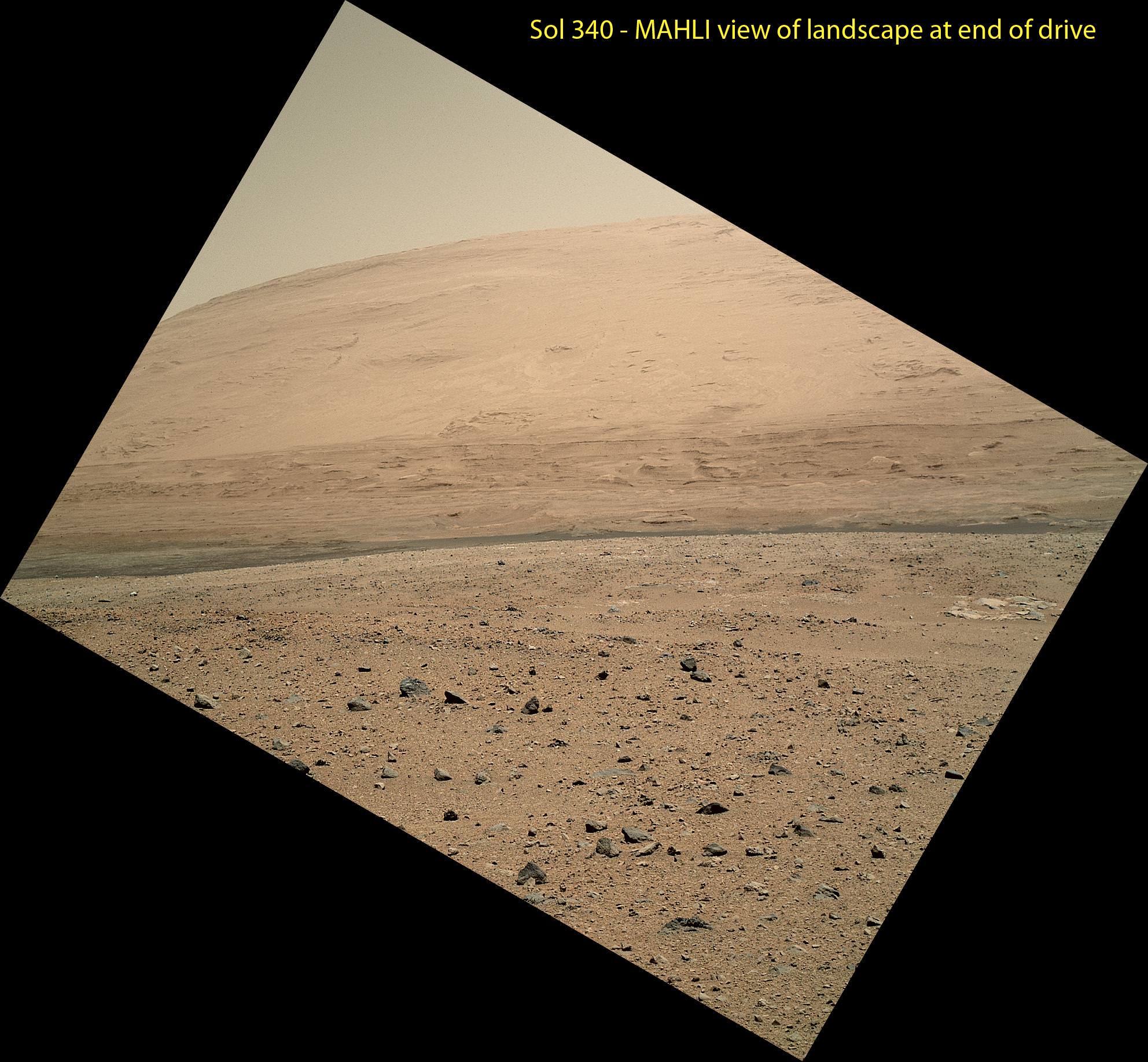
The scene taken on Sol 340 was taken shortly after Curiosity finished her longest yet. The 329.1-foot (100.3-meter) drive was twice as long as any previous sol's drive by Curiosity. The view is toward the south, including a portion of Mount Sharp and a band of dark dunes in front of the mountain. The Mars Hand Lens Imager (MAHLI) camera on NASA's Curiosity rover is carried at an angle when the rover's arm is stowed for driving. Still, the camera is able to record views of the terrain Curiosity is crossing in Gale Crater, and rotating the image 150 degrees provides this right-side-up scene. Credit: NASA/JPL-Caltech/MSSS
This scene was taken on Sol 340 shortly after Curiosity finished her longest drive yet
The 329.1-foot (100.3-meter) drive was twice as long as any previous sol’s drive by Curiosity. The view is toward the south, including a portion of Mount Sharp and a band of dark dunes in front of the mountain. The Mars Hand Lens Imager (MAHLI) camera on NASA’s Curiosity rover is carried at an angle when the rover’s arm is stowed for driving. Still, the camera is able to record views of the terrain Curiosity is crossing in Gale Crater, and rotating the image 150 degrees provides this right-side-up scene. Credit: NASA/JPL-Caltech/MSSS
See updated Traverse Map below[/caption]
NASA’s car-sized Curiosity rover is now blazing across the Red Planet’s surface and moving at a record setting pace towards a towering Martian mountain loaded with mineral caches that could potentially support a habitable environment.
On Sunday, July 21 (or Sol 340), Curiosity drove the length of a football field – 109.7 yards (100.3 meters) – a span that’s twice as far as she had ever driven before since the dramatic touch down on Mars nearly a year ago.
The previous record for a one-day drive was about half a football field – 54 yards (49 meters) – and achieved on Sol 50 (Sept. 26, 2012), roughly seven weeks after the pulse pounding landing inside Gale Crater on Aug. 6, 2012.
The 6 wheeled robot was able to move so far because on the prior drive she wound up atop a rise offering an uncommonly good view of the surrounding landscape and the road ahead across the crater floor towards Mount Sharp – the ultimate driving goal.
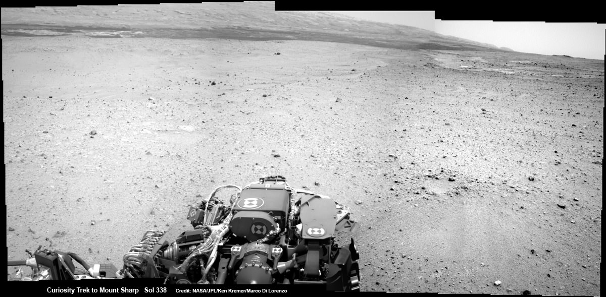
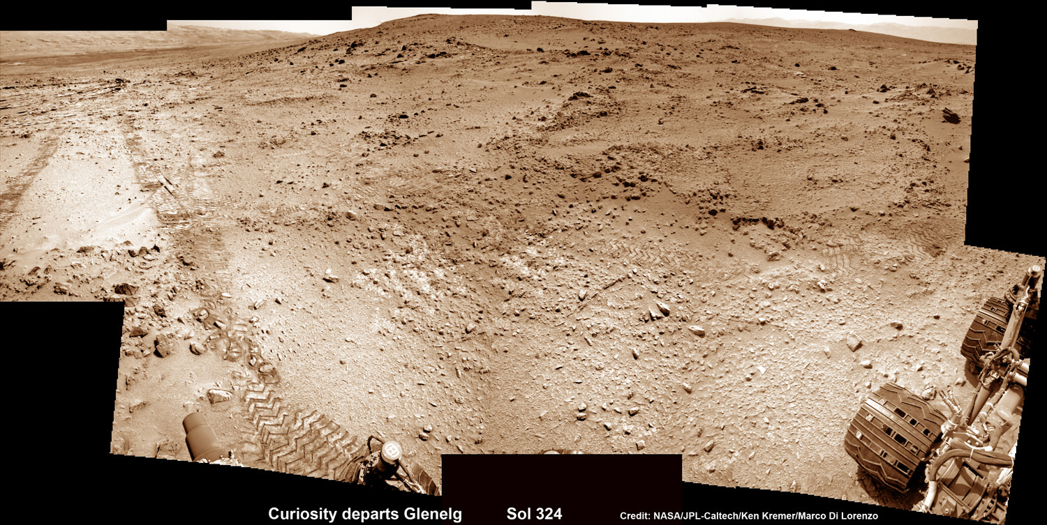
Curiosity On the Road to Mount Sharp and treacherous Sand Dunes – Sol 338 – July 19
Curiosity captured this panoramic view of the path ahead to the base of Mount Sharp and potentially dangerous sand dunes after a recent drive on July 19, 2013. She must safely cross over the dark dune field to climb and reach the lower sedimentary layers of Mount Sharp.
Credit: NASA/JPL-Caltech/Ken Kremer-(kenkremer.com)/Marco Di Lorenzo
“What enabled us to drive so far on Sol 340 was starting at a high point and also having Mastcam images giving us the size of rocks so we could be sure they were not hazards,” said rover planner Paolo Bellutta of NASA’s Jet Propulsion Laboratory, Pasadena, Calif, in a NASA statement.
“We could see for quite a distance, but there was an area straight ahead that was not clearly visible, so we had to find a path around that area.”
Following another lengthy drive of 68.2 yards (62.4 meters) on Wednesday, July 23 (Sol 342), the mission’s total driving distance so far stands at 0.81 mile (1.23 kilometers).
Mount Sharp lies about 5 miles (8 kilometers) distant – as the Martian crow flies.
On July 4, Curiosity embarked on the epic trek to Mount Sharp after completing more than seven months of science investigations and historic interplanetary drilling and sample analysis at an area known as Glenelg and Yellowknife Bay. There she discovered a habitable environment with the chemical ingredients that could sustain Martian microbes- thereby already accomplishing the primary goal of NASA’s flagship mission to Mars.
A combination of increased experience by the engineers directing the mega rover as well as intermediate software upgrades also play key roles in speeding Curiosity towards 3.4 mile (5.5 km) high Mount Sharp.
A huge leap in roving across Mars is in the works soon using new driving software called autonomous navigation, or autonav, that will hasten the overland journey.
“We have put some new software – called autonav, or autonomous navigation – on the vehicle right after the conjunction period back in March 2013,” said Jim Erickson, Curiosity Project Manager, in exclusive interview with Universe Today. Erickson is from NASA’s Jet Propulsion Laboratory (JPL) in Pasadena, Calif.
“This will increase our ability to drive.”
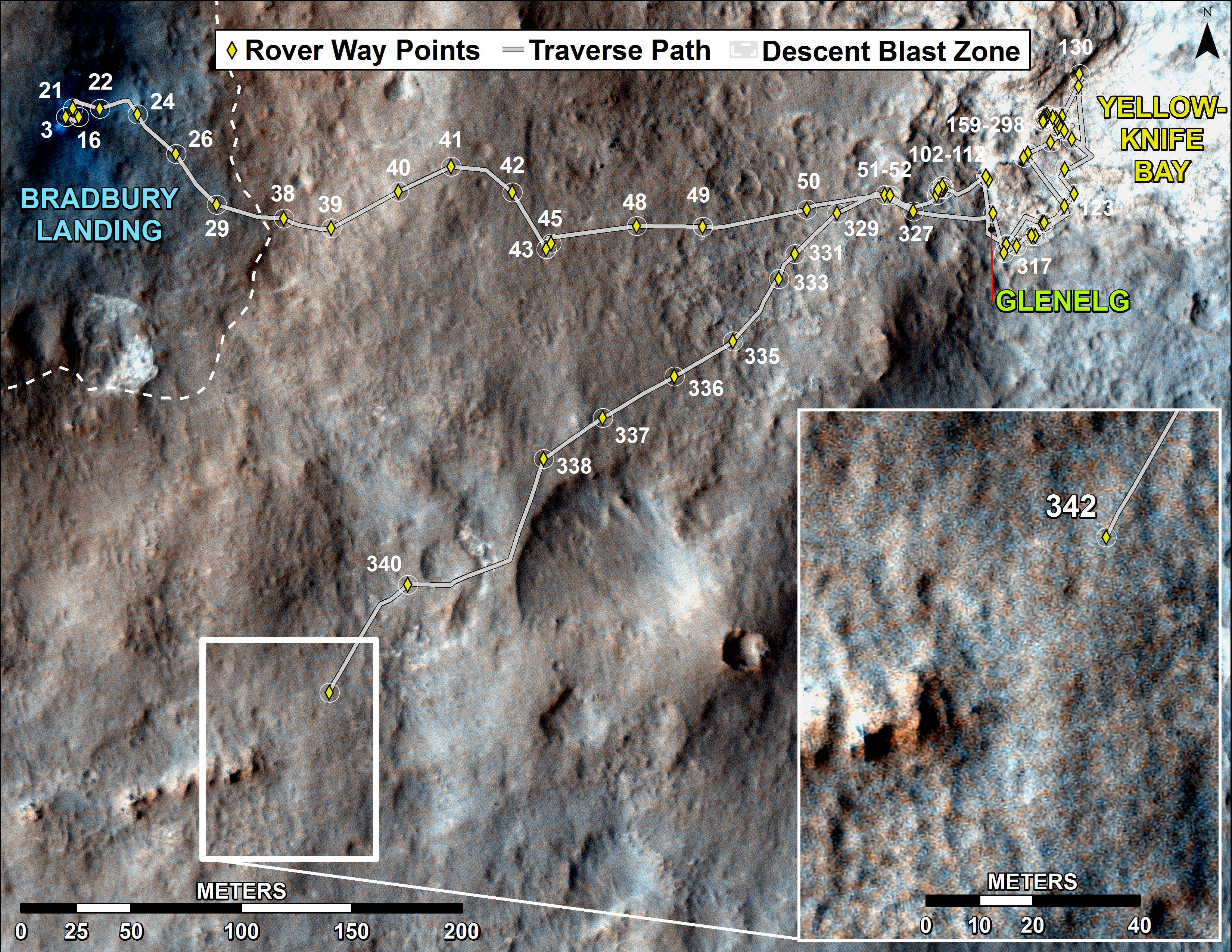
Curiosity’s Traverse Map Through Sol 342
This map shows the route driven by NASA’s Mars rover Curiosity through the 342 Martian day, or sol, of the rover’s mission on Mars (July 21, 2013). Numbering of the dots along the line indicate the sol number of each drive. North is up. The scale bar is 200 meters (656 feet). From Sol 340 to Sol 342, Curiosity had driven a straight line distance of about 191.9 feet (58.49 meters). The base image from the map is from the High Resolution Imaging Science Experiment Camera (HiRISE) in NASA’s Mars Reconnaissance Orbiter. Image Credit: NASA/JPL-Caltech/Univ. of Arizona
Implementing the new driving software will make Curiosity smarter as well as more capable, productive and independent than ever before.
“With autonav the rover will have the ability to understand how far it’s driving, whether its slipping or not, and it improves safety,” Erickson told me.
The rover’s route is on a southwestward heading towards the ancient sedimentary layers at the foothills of the mountain in the middle of Gale Crater.
In addition to setting new driving records, the 1 ton rover is also driving more frequently and on repeated days too.
When everything synchs up, Curiosity can drive two or more days in row.
“We can drive two days in a row now if the timing is right. If we get the results of the day’s drive (n) in time before we have to plan the next day’s drive (n+1) – almost as if you’re on Mars time. Then that would work fine,” Erickson explained.
“Also, when we get the autonav capability we can plan two days in row. One day of directed driving and the second day can be ‘OK here’s your target from wherever you end up, try and go to this spot’.”
“This will increase the productivity!”
Erickson says the team is testing autonav now and should it be up and running within weeks, or sooner.
Read Part 1 & Part 2 of my interview with Jim Erickson for further details.
This photomosic shows NASA’s Curiosity departing at last for Mount Sharp- her main science destination. Note the wheel tracks on the Red Planet’s surface. The navcam camera images were taken on July 4, 2013 (Sol 324). Credit: NASA/JPL-Caltech/Ken Kremer (kenkremer.com)/Marco Di Lorenzo
Meanwhile Curiosity’s older sister rover Opportunity is making fast tracks towards her own mountain goal and should arrive at the base of Solander Point rather soon in August.
Solander Point is a segment of the eroded rim of huge Endeavour crater and may also possess key ingredients essential to support an environment favorable for possible Martian microbes.
And it’s worth noting that older sis Opportunity stills holds the 1 day Martian distance driving world record of 219.89 meters – established more than 8 years ago on Sol 410 (March 20, 2005)!!
Stay tuned for more on NASA’s sojourning pair of Martian robots.
When it comes to carbon dioxide, just a little goes a long way to warming the planet. Unfortunately, we’ve been dumping vast amounts into the atmosphere, recently passing 400 parts per million. Let’s look at the science of the greenhouse effect, and how it’s impacting our global climate.
And the podcast is also available as a video, as Fraser and Pamela now record Astronomy Cast as part of a Google+ Hangout (usually recorded every Monday at 3 pm Eastern Time):
If you’ve ever been involved in one, you know that even a minor vehicle accident is a confusing and scary event. Trying to desperately regain control of your own movement as you’re suddenly subjected to forces beyond your control is stressful and terrifying… now imagine it happening at 17,500 mph and 230 miles up and you’ve got an idea of what the upcoming film “Gravity” is about.
Still can’t quite picture it? Check out the latest trailer below:
Directed and written by Alfonso Cuarón and co-written with his son Jonas, “Gravity” is the story of two astronauts (played by George Clooney and Sandra Bullock) whose shuttle is destroyed by a run-in with space junk during an EVA, stranding them both in orbit.
If that wasn’t bad enough, their oxygen is running out and they have lost communication with the ground. Cast adrift in orbit, they have to figure out how to survive and get back home.
It’s like “Open Water” in space. Without the sharks. (Let’s hope things turn out better for them!)
I enjoy sci-fi and I especially enjoy when they try to get the “sci” part right. How do things move in microgravity? (Hint: really fast.) What happens when stuff smashes together? What would happen to the human body in that situation? And, most importantly for any movie, how do the people involved handle the experience?
Above all, “Gravity” is still a movie so it has to take us on a two-hour, candy-munching, soda-slurping ride. Based on this latest trailer, I’m confident that they’ve done their homework on the mechanics of movement in orbit… now let’s see if Cuarón (Children of Men, Y Tu Mamá También, Harry Potter and the Prisoner of Azkaban) has once again worked his storytelling magic to bring the characters to free-falling life.
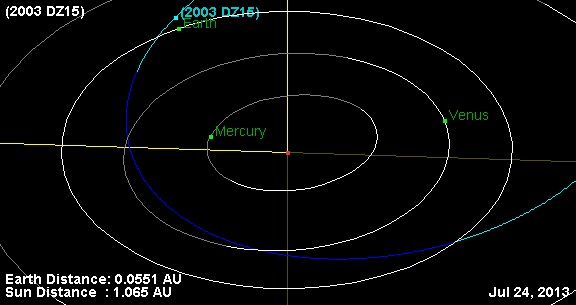
The currnet orbital position of asteroid 2003 DZ15. (Created by the author using JPL's Small-Body Database Browser).
The Earth will get another close shave Monday, when the 152 metre asteroid 2003 DZ15 makes a pass by our fair planet on the night of July 29th/30th at 3.5 million kilometres distant. This is over 9 times the Earth-Moon distance and poses no threat to our world.
This is much smaller than 2.75 kilometre 1998 QE2, which sailed by (bad pun intended) our fair world at 5.8 million kilometres distant on May 31st, 2013. The Virtual Telescope Project will be presenting a free online event to monitor the passage of NEA 2003 DZ15 starting Monday night July 29th at 22:00 UT/6:00 PM EDT.
As of this writing, no efforts are currently known of by professional observatories to monitor its passage via radar, though Arecibo may attempt to ping 2003 DZ15 on Thursday.
An Apollo asteroid, 2003 DZ15 was confirmed by the Lowell Observatory and NEAT’s Mount Palomar telescope upon discovery in February 2003. This is its closest approach to the Earth for this century, although it will make a pass nearly as close to the Earth in 2057 on February 12th.
With a perihelion (closest approach to the Sun of) 0.63 A.U.s, 2003 DZ15 can also make close passes by the planet Venus as well, which it last did in 1988 and will do again on 2056.
Closest approach of 2003 DZ15 is set for 00:37 UT July 30th, or 8:37 PM EDT the evening of Monday, July 29th. Although it will only reach about +14th magnitude (based on an absolute magnitude of +22.2), and hence be out of range to all but the very largest Earthbound backyard telescopes, it’ll be fun to watch as it slowly drifts across the starry background live on the internet. Our own, “is worth tracking down from our own backyard” limit is an asteroid passing closer than our Moon, or is farther, but is brighter than +10th magnitude… such are the limitations of humid Florida skies!
Of course, an asteroid the size of 2003 DZ15 would spell a bad day for the Earth, were it headed our way. At an estimated 152 metres in size, 2003 DZ is over seven times the size of the Chelyabinsk meteor that exploded over Russia the day after Valentine ’s on February 15th of this year. While not in the class of an Extinction Level event, 2003 DZ15 would be in 60 to 190 metre size of range of the Tunguska impactor that struck Siberia in 1908.
All enough for us to take notice as 2003 DZ15 whizzes by, at a safe distance this time. NASA plans to launch a crewed mission sometime over the next decade to study an asteroid, and perhaps retrieve a small NEA and place it in orbit about Earth’s Moon. Such efforts may go a long way in understanding and dealing with such potentially hazardous space rocks, when and if the “big one” is discovered heading our way. We’re the Earth’s first line of defense- and unlike the ill-fated dinosaurs, WE’VE got a space program and can do something about it!
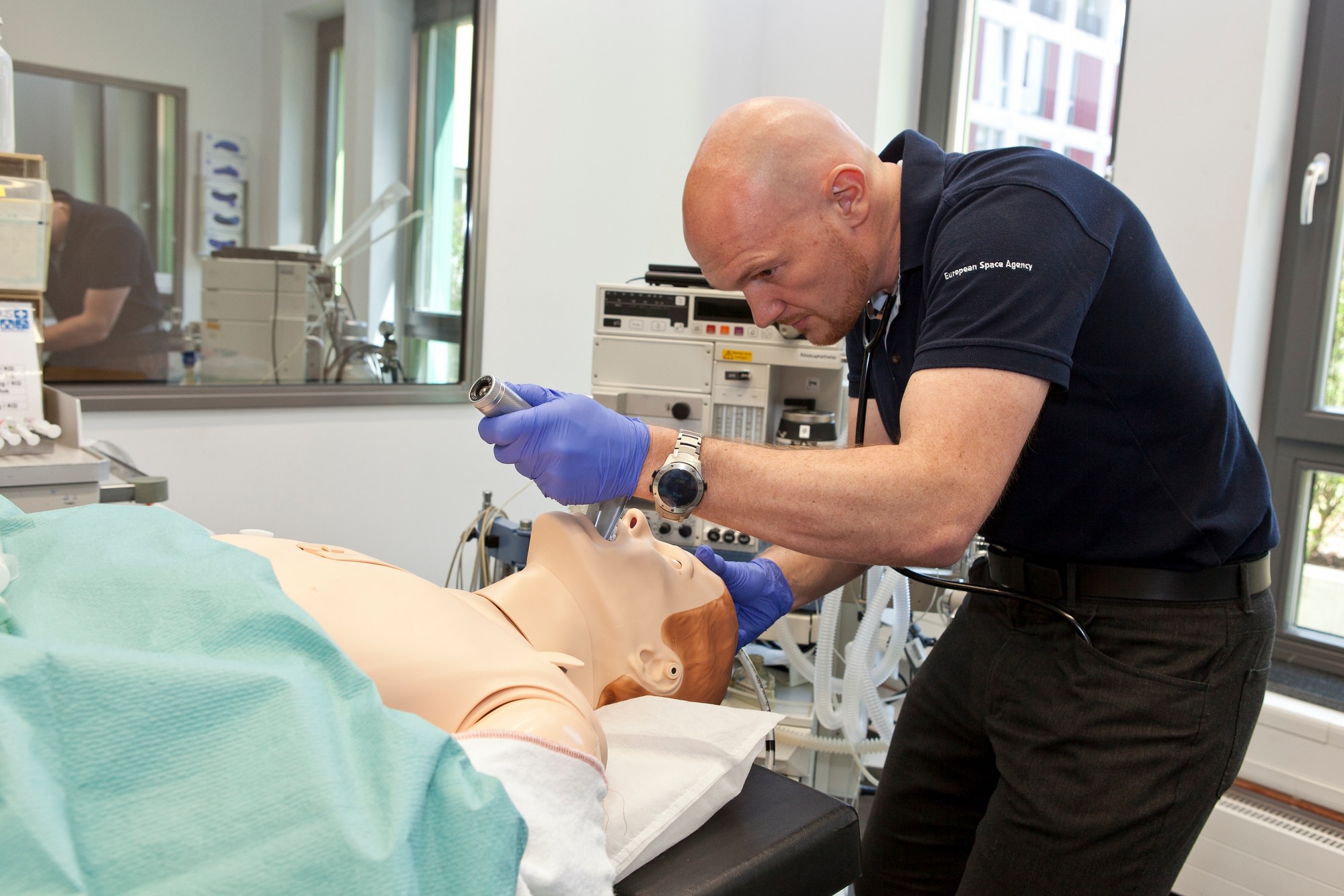
ESA astronaut Alexander Gerst practicing his medical skills on a mannequin. Credit: European Space Agency
Should an astronaut get sick on the International Space Station, that could be a bad scene given the nearest hospital requires a spaceship ride. That’s why every crew has at least two medical officers on board that can deal with some routine procedures, getting to items as complex as filling teeth, for example.
How to get that training done?
Here’s an example: above is Alexander Gerst, an astronaut with the European Space Agency, recently working with a mannequin at the Uniklinik Köln, a hospital in Cologne, Germany. The mannequin is at least as realistic as some baby dolls you can buy in stores: “it blinks, breathes and responds to injections”, ESA stated.
That’s in addition to three days Gerst spent in operating theatres, emergency and the intensive care unit at the hospital. He has about another year to do medical training before going to station for Expedition 40/41 in May 2014.
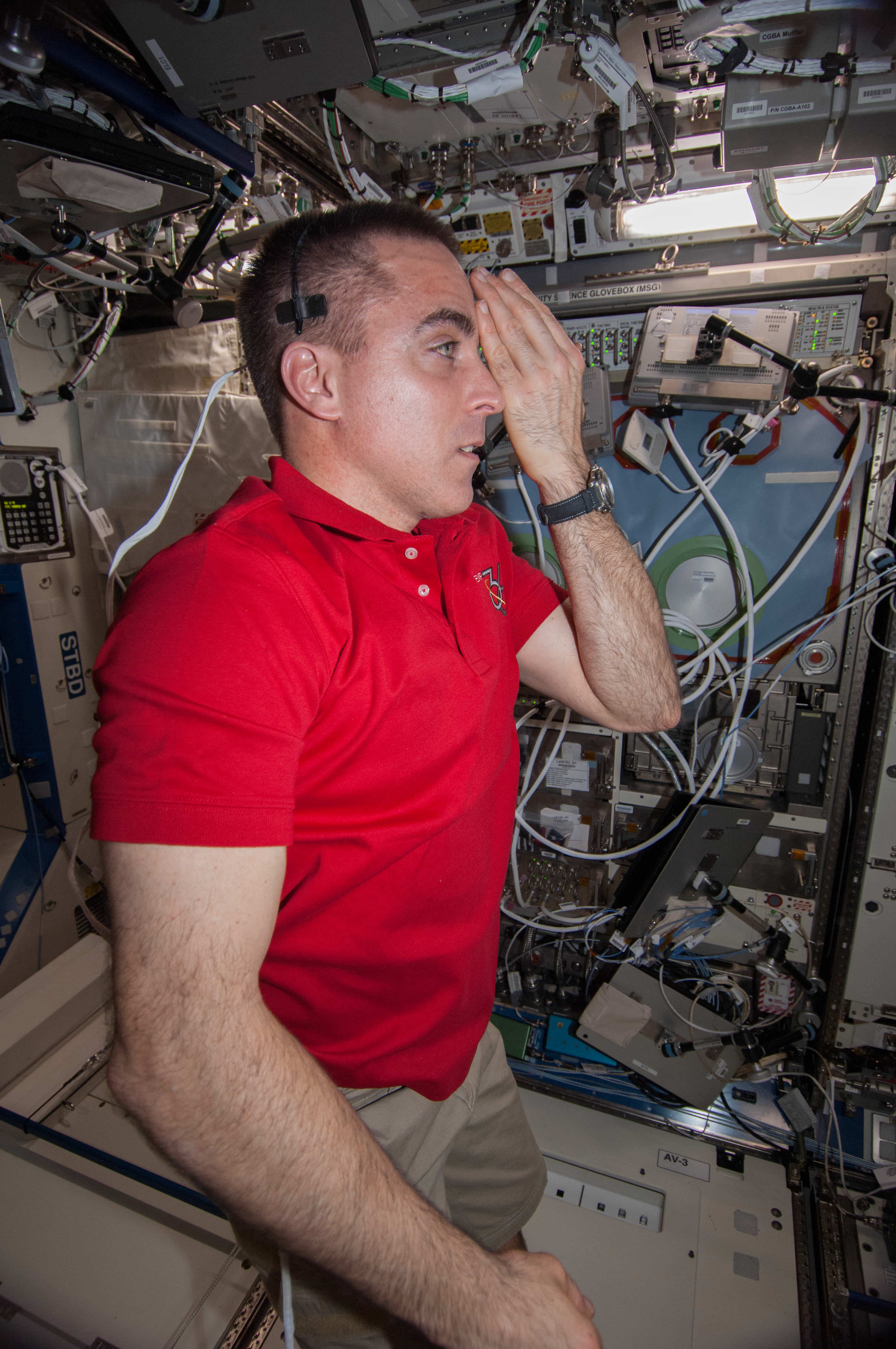
Chris Cassidy, an Expedition 36 flight engineer, tests his eyesight aboard the International Space Station. Credit: NASA
Mind you, help is also a phone call away to a ground control station, who has doctors on site. Also, there are a lot of medical doctors or similarly trained personnel that fly in space.
On board the International Space Station right now is a trained Navy SEAL, for example: Chris Cassidy. He would have been trained to treat injuries during combat. In May, he told Universe Today that he expects “muscle memory” would kick in during an emergency, whether medical or station-related:
“I think just the training that I got in the field, training in the early part of my Navy career, and during my time being an astronaut will all combine together,” he said.
“What I know from combat in the Navy, there’s a sort of calmness that comes over people who are well-trained and know what to do. Muscle memory kicks in, and it’s not until after the thing is over that you realize what you went through.”
While those who fly in space train for medical emergencies, they also serve as medical guinea pigs for ongoing experiments. Turns out microgravity simulates aging processes on Earth, so the research could have benefits on the ground in future decades. Here’s a couple of experiments happening right now on station:
Space Headaches: “Current, pre, in-flight and post-flight data via questionnaires to evaluate the prevalence and characteristics of crewmembers’ headaches in microgravity.”
Reaction Self Test: “A portable 5-minute reaction time task that will allow the crewmembers to monitor the daily effects of fatigue on performance while on board the International Space Station.”
Looking at the medical aspect alone, it’s abundantly clear why astronauts spend years in training before flying to the station. Remember, though, this is on top of other science experiments they do there, not to mention repairs, maintenance and the occasional spacewalk or catching a supply spacecraft.
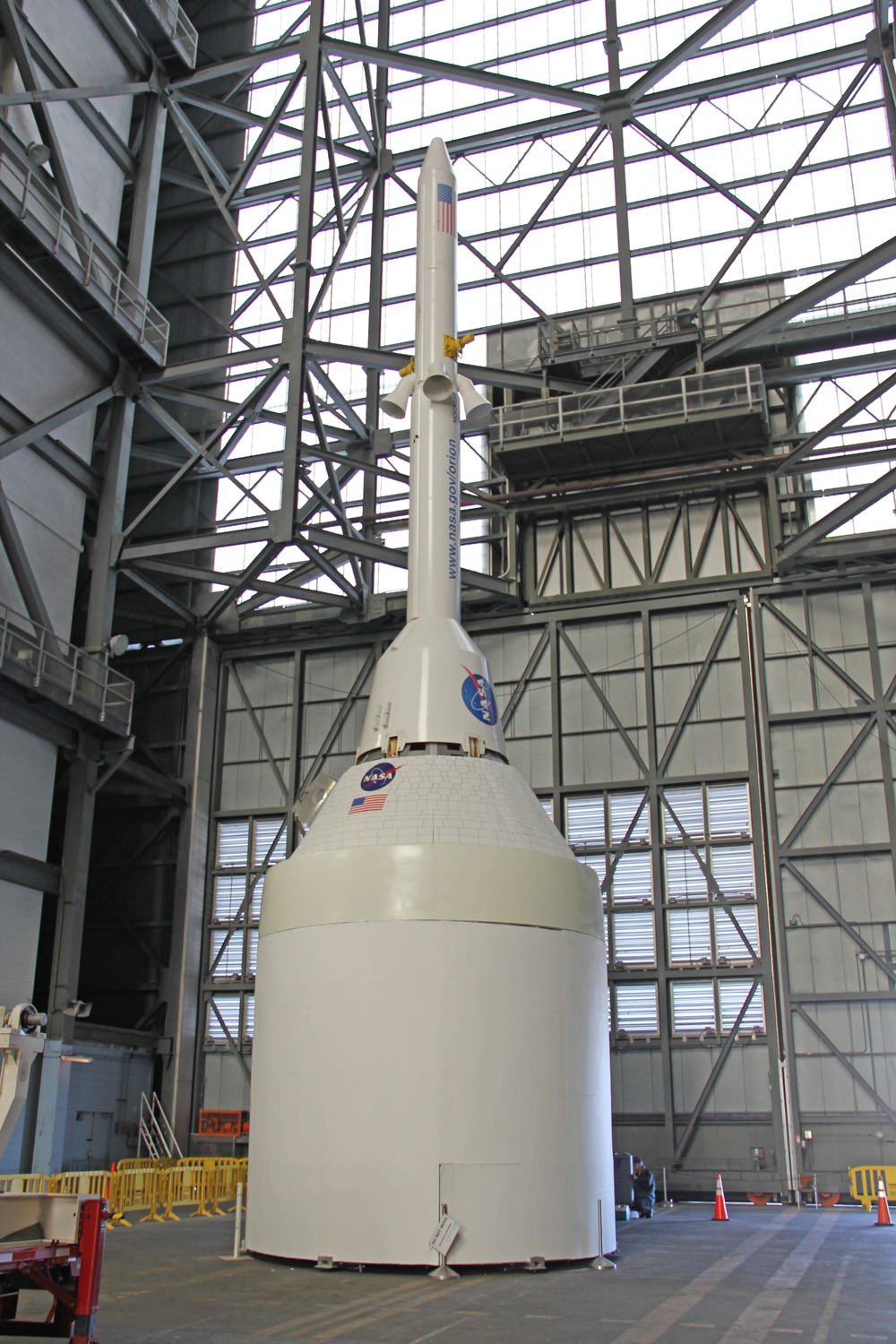
Orion crew capsule, Service Module and 6 ton Launch Abort System (LAS) stack inside the transfer aisle of the Vehicle Assembly Building (VAB) at the Kennedy Space Center (KSC) in Florida. Powerful quartet of LAS abort motors will fire in case of launch emergency to save astronauts lives. Credit: Ken Kremer/kenkremer.com
NASA is testing out the parachutes for the new Orion crew vehicle, and in a first, is broadcasting it live as a Google+ Hangout from the U.S. Army’s Yuma Proving Ground in Arizona. They are also going to make something bad happen, and will be happy if it works! Watch live above (from 10:30 to 11:30 a.m. EDT July 24) or watch the replay later as an Orion test capsule is dropped from a plane at 10,700 meters (35,000 feet) to evaluate its parachutes.
Engineers will simulate a failure of one of the spacecraft’s three main parachutes, releasing it before Orion has landed.
Update: Despite a bad video feed, the test was a success.
“The closer we can get to actual flight conditions, the more confidence we gain in the system,” said Chris Johnson after the test. Johnson is project manager for the Orion capsule parachute assembly system at NASA’s Johnson Space Center in Houston. “What we saw today — other than the failures we put in on purpose — is very similar to what Orion will look like coming back during Exploration Flight Test-1’s Earth entry next year.”
One of three massive main parachutes was cut away early on purpose, and so the spacecraft was left with just two parachutes. However, the capsule still landed safely. Wednesday’s test was the highest-altitude test of a human spacecraft parachute since NASA’s Apollo Program.
During previous tests for Orion’s parachutes, a mock capsule was dropped from a height of 25,000 feet and the parachutes deployed at no higher than 22,000 feet. The extra 10,000 feet of altitude at the beginning of Wednesday’s test made the demonstration the best so far of Orion’s parachute flight and landing.
This test was in preparation for the Exploration Flight Test-1, an uncrewed test of the spacecraft that will send Orion 5,800 km (3,600 miles) away from Earth, scheduled for September 2014. Orion’s parachutes are being tested to ensure they can slow the capsule for a safe landing in the Pacific Ocean as the spacecraft reenters Earth’s atmosphere from deep space missions at speeds of up to 32,000 km/h (20,000 mph.)
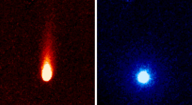
These images from NASA's Spitzer Space Telescope of C/2012 S1 (Comet ISON) were taken on June 13, when ISON was 310 million miles (about 500 million kilometers) from the sun. Image credit: NASA/JPL-Caltech/JHUAPL/UCF
As part of the Comet ISON Observing Campaign, the Spitzer Space Telescope was used to “stare” at the comet for 24 hours on Jun 13, 2013. Images from Spitzer’s “ISON-a-thon” indicate that carbon dioxide and dust are spewing out of the comet at a fairly large rate.
“We estimate ISON is emitting about 2.2 million pounds (1 million kilograms) of what is most likely carbon dioxide gas and about 120 million pounds (54.4 million kilograms) of dust every day,” said Carey Lisse, leader of NASA’s Comet ISON Observation Campaign and a senior research scientist at the Johns Hopkins University Applied Physics Laboratory.
That amount of dust is about the mass of one aircraft carrier every two days or so, tweeted the Sungrazing Comets Twitter feed,, and the amount of carbon dioxide released per day would be enough for about 625 million cans of soda.
The images were taken by the Spitzer’s Infrared Array Camera showing the comet’s tail, which is about 186,400 miles (300,000 kilometers) long.
Comet ISON was about 312 million miles (502 million kilometers) from the Sun, 3.35 times farther than Earth, when the observations were made.
Comet ISON (C/2012 S1) is less than 3 miles (4.8 kilometers) in diameter (about the size of a small mountain) and weighs between 7 billion and 7 trillion pounds (3.2 billion and 3.2 trillion kilograms). However, its true size and density have not yet been accurately determined because of its distance from Earth. Like all comets, ISON is a dirty snowball made up of dust and frozen gases such as water, ammonia, methane and carbon dioxide. These are some of the fundamental building blocks, which scientists believe led to the formation of the planets 4.5 billion years ago.
“This observation gives us a good picture of part of the composition of ISON, and, by extension, of the proto-planetary disk from which the planets were formed,” said Lisse. “Much of the carbon in the comet appears to be locked up in carbon dioxide ice. We will know even more in late July and August, when the comet begins to warm up near the water-ice line outside of the orbit of Mars, and we can detect the most abundant frozen gas, which is water, as it boils away from the comet.”
The comet will pass within 724,000 miles (1.16 million kilometers) of the Sun on Nov. 28.
Astronomers are wondering if the comet will survive its close pass of the Sun, and also if it will live up to expectations of becoming bright enough to be seen in the daytime, as some have predicted.
Only time will tell … and we’ll be here to share the news.
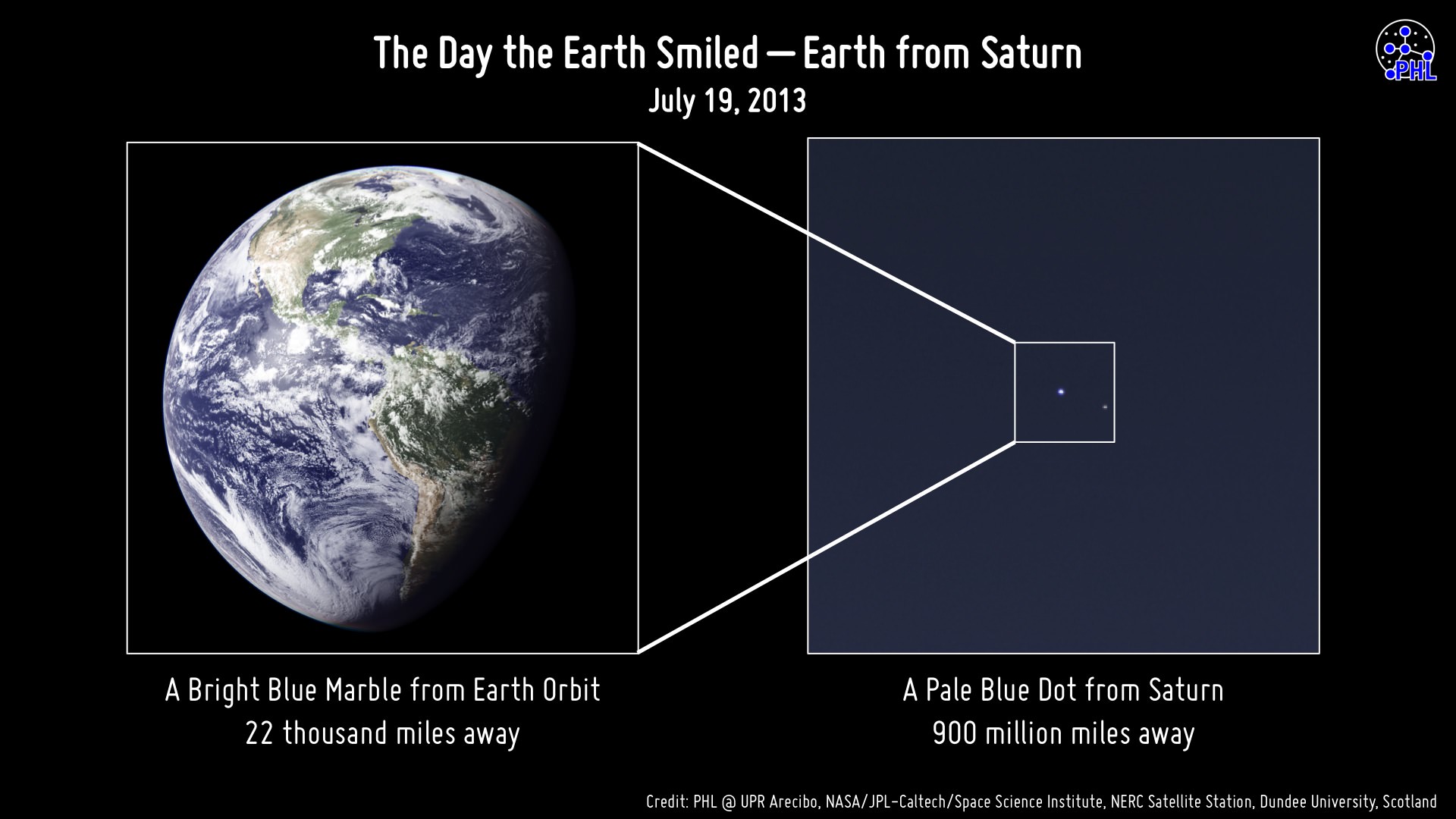
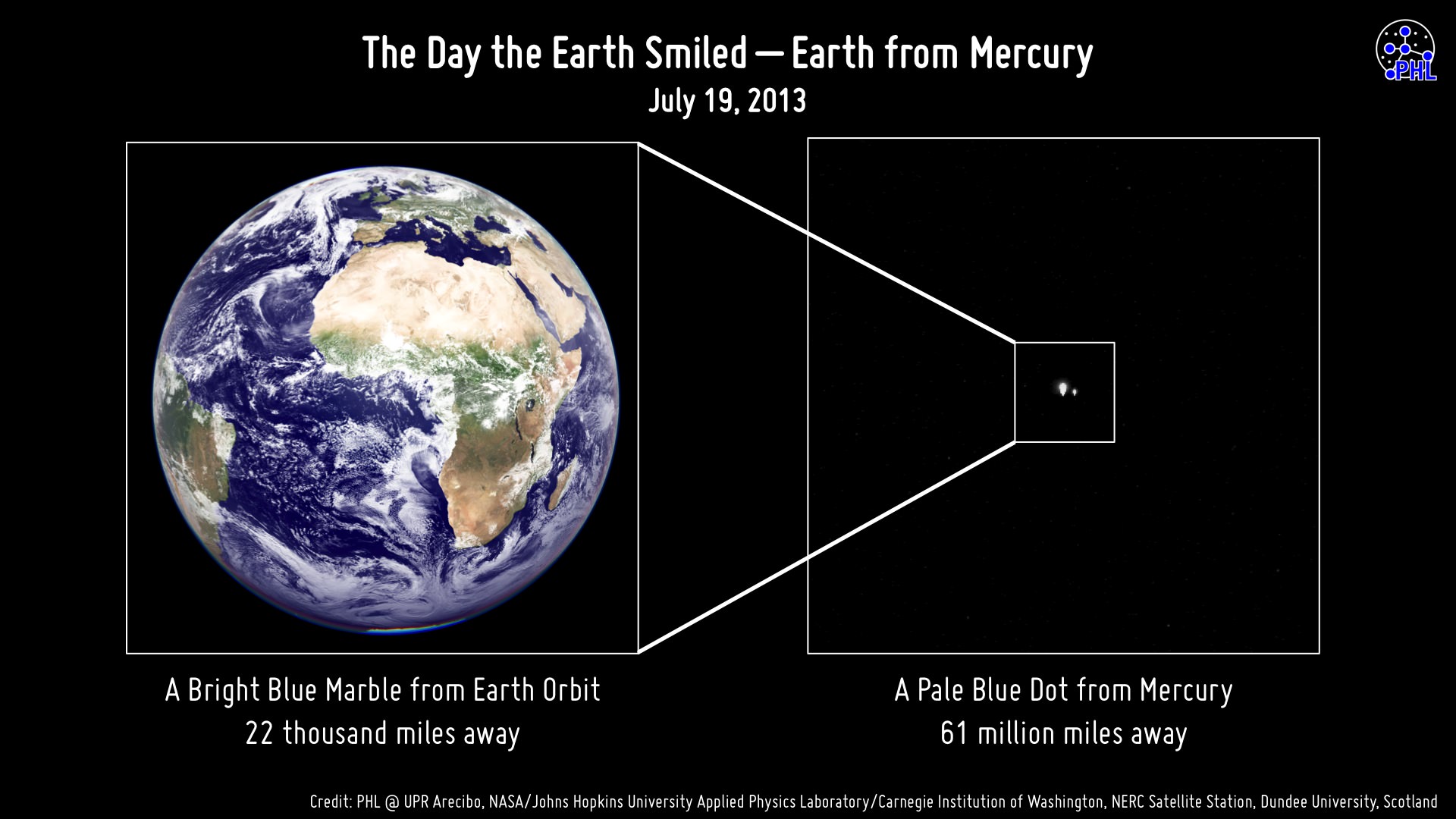
The face of Earth aimed toward Cassini during imaging on July 19, 2013
So along with the rest of the world, you smiled. You waved. You went outside on July 19, wherever you were, and looked upwards and out into the solar system knowing that our robotic representative Cassini would be capturing a few pixels’ worth of photons bouncing off our planet when they eventually reached Saturn, 900 million miles away. But did Cassini actually capture any photons coming from where you were? The image above will tell you.
Assembled by the Planetary Habitability Laboratory at the University of Puerto Rico at Arecibo (where the enormous 305-meter radio telescope is located) this image shows what side of Earth was facing Cassini when its “pale blue dot” images were obtained, at approximately 22:47 UTC (Cassini time.)
Didn’t make it into Cassini’s photo? That’s ok… maybe MESSENGER had already caught you earlier that very same day:
The view of Earth seen by MESSENGER from Mercury on July 19, 2013
Before Cassini took its images — several hours before, in fact — the MESSENGER spacecraft was holding some photo shoots of its own from 61 million miles in the other direction!
The image above shows the side of Earth that was facing Mercury on the morning of July 19, 2013, when MESSENGER was acquiring images in our direction during a hunt for any possible satellites of the innermost planet.
Earth was as bright (-4.8 magnitude) as the maximum brightness of Venus at the moment the image was taken from Mercury.
Of course, in both series of images specific details of our planet can’t be made out — Earth was barely more than a pixel in size (regardless of any bloom caused by apparent brightness.) Clouds, countries, continents, oceans… the entire population of our world, reduced to a single point of light — a “mote of dust suspended in a sunbeam.”
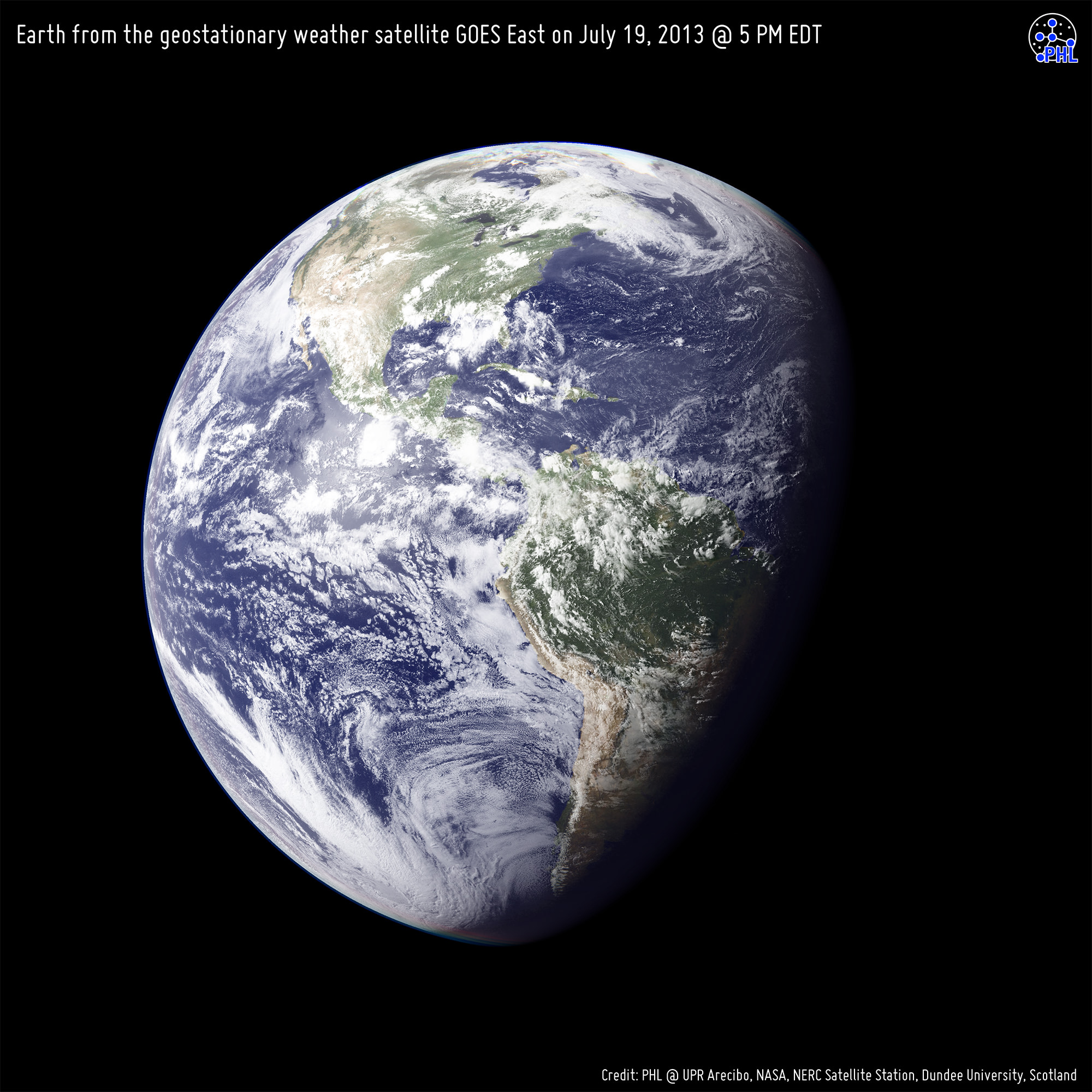
For both portrayals, high-resolution black and white images from the GOES East and Meteosat meteorological satellites were combined with color information from NASA Visible Earth to generate true-color images of our planet as it would have looked to each respective imaging spacecraft… if they had the impossibly-precise optics to resolve Earth from such distances, of course.
But it’s ok that they don’t… we can still use our imaginations.
Earth from the geostationary weather satellite GOES East on July 19, 2013 at 5 PM EST. This is approximately the view that Cassini would have had of Earth during imaging.
Image credits: PHL @ UPR Arecibo, NASA/Johns Hopkins University Applied Physics Laboratory/Carnegie Institution of Washington, NERC Satellite Station, Dundee University, Scotland. Thanks to Prof. Abel Méndez (PHL/UCR) for the heads-up on these.
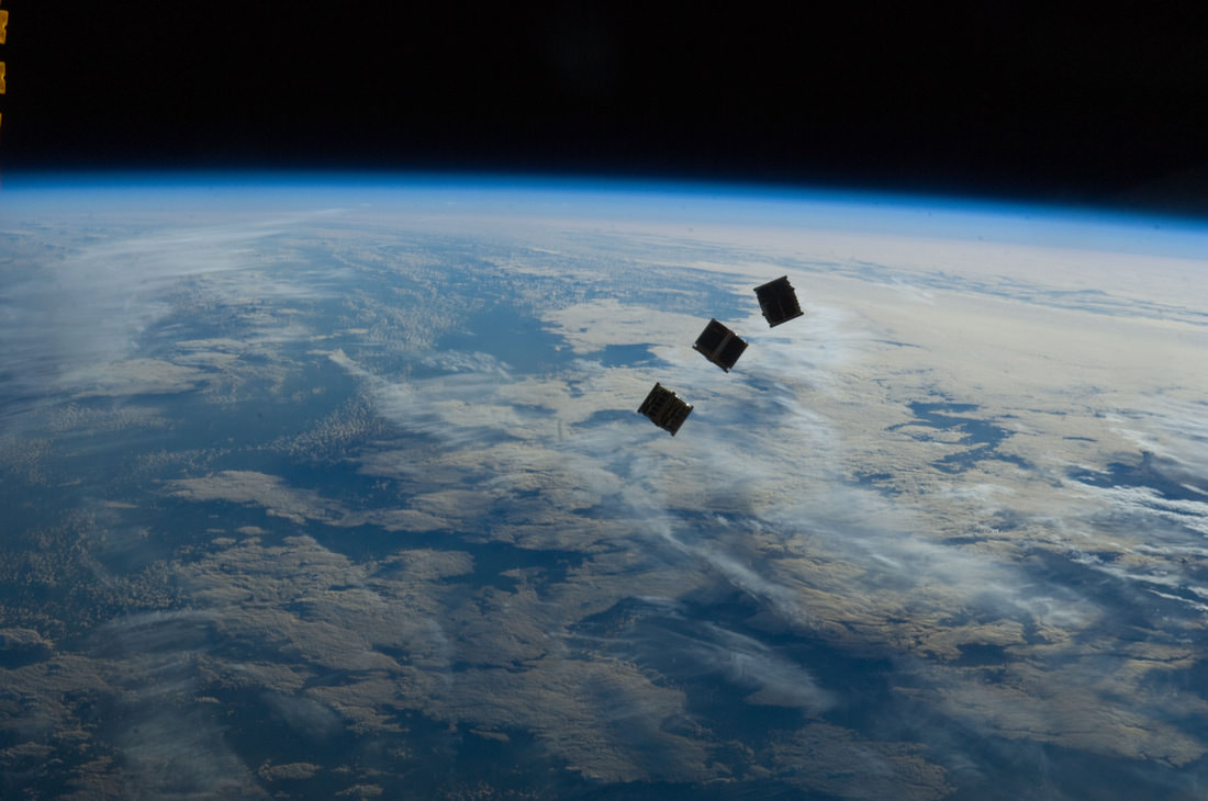
Three small CubeSats are deployed from the International Space Station on October 4, 2012. Credit: NASA
We’ve had several articles recently cubesats — low-cost satellites that seem to be the wave of the future. As technology becomes miniaturized, this allows for inexpensive and quick-to-build satellites. Additionally, they can tag along on launches already scheduled for other things. All this enables students and smaller companies to send equipment and experiments into space.
But the people from DIY Space Exploration say don’t let the small size of a cubesat fool you. The types of missions Cubesats can perform may surprise you and they’re becoming the satellite of choice for anyone looking for a low cost quick response option.
If you visit the DIY Space Exploration website, they have tutorials on how you can put your own cubesat together, and lots of other information. They’ve also put together a great infograhic about what all you can do with a cubesat: