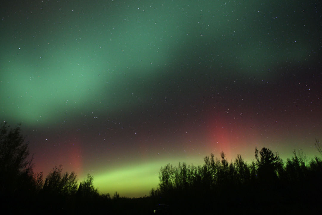
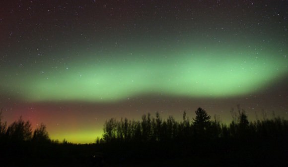
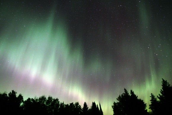
At around 10 p.m. last night, the northern sky was alive with colorful auroral patches and arcs. Details: 15mm lens at f/2.8, ISO 800 and 25 second exposure. Credit: Bob King
I’m writing this at 1:30 a.m. running on what’s powering the sky over northern Minnesota right now – auroral energy. Even at this hour, rays are still sprouting in the southern sky and the entire north is milky blue-white with aurora borealis. Frankly, it’s almost impossible to resist going out again for another look.
Now updated with additional images.
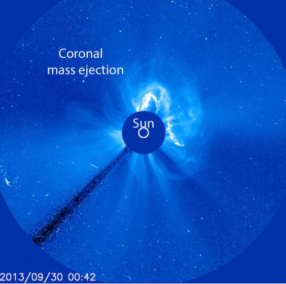
An erupting filament and sharp, southward dip in the interplanetary magnetic field (IMF) was responsible for last night’s northern lights show. This image was taken with the Solar and Heliospheric Observatory’s sun-blocking coronagraph on Sept. 30. Credit: NASA/ESA
The arrival of a powerful solar wind in excess of 375 miles per second (600 km/second) from a coronal mass ejection shocked the Earth’s magnetic sheath last night beginning around 9 p.m. CDT. The sun’s magnetic field, embedded in the wind, pointed sharply southward, allowing eager electrons and protons to worm their way past our magnetic defenses and excite the atoms in the upper atmosphere to glow. Voila! Northern lights.
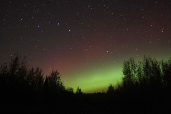
A classic quiet start to Tuesday night’s northern lights – a low green arc below the Big Dipper topped by a very faint red border. Credit: Bob King
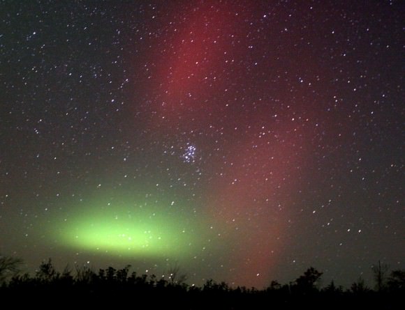
Sure, it started innocently enough. A little glow low in the northern sky. But within half an hour the aurora had intensified into a dense bar of light so and green and bright it cast shadows. This bar or swath grew and grew like some atomic amoeba until it swelled beyond the zenith into the southern sky. Meanwhile, an isolated patch of aurora glowed like an green ember beneath the Pleiades in the northeastern sky. The camera captured its eerie appearance as well as spectacular curtains of red aurora dancing above the dipper-shaped cluster.
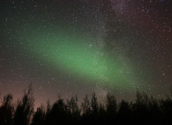
A single patch of aurora glows beneath the Pleiades star cluster at center. Beautiful red rays as seen in the time exposure were only faintly visible with the naked eye. Credit: Bob King
Soft patches, oval glows and multiple arcs lit up the north, east and west, but in the first two hours of the display I never saw a ray or feature with any definition. The camera recorded a few but all was diffuse and pillowy to the eye. Rays finally made their appearance later – after midnight and later – when they massed and surged to the zenith and beyond.
Looks a little scary. A thick wall of green aurora surges upward in the northern sky headed for the zenith. Credit: Bob King
Then came the flickering, flame-like patches and snaky shapes writhing lifelike across the constellation Pegasus during the phase called the coronal aurora. That’s when all the curtains and rays gather around the local magnetic zenith. As they flicker and flame, their shapes transform into eagle wings and snakes wriggling across the stars.
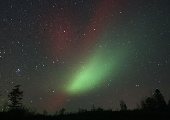
A large comet-like auroral form accented with red rays took up residence in the southeastern sky in Cetus from about 10:15 until 11 p.m. last night. around 10:30 p.m. Credit: Bob King
Funny, the space weather forecast called for quiet conditions last night and for the next two nights. But the eruption of a large filament, a tubelike region of dense hydrogen gas held aloft in the sun’s atmosphere by magnetic fields, sent a bundle of subatomic joy in Earth’s direction a bit earlier than expected. More auroras are possible tonight and tomorrow night as the effect of the shock wave continues. Despite the U.S. government shutdown, the Space Weather Prediction Center remains open.
There are so many ways to appreciate the aurora but my favorite is simply to stand there dumbfounded and try to take it all in. Few phenomena in nature are more deeply moving.
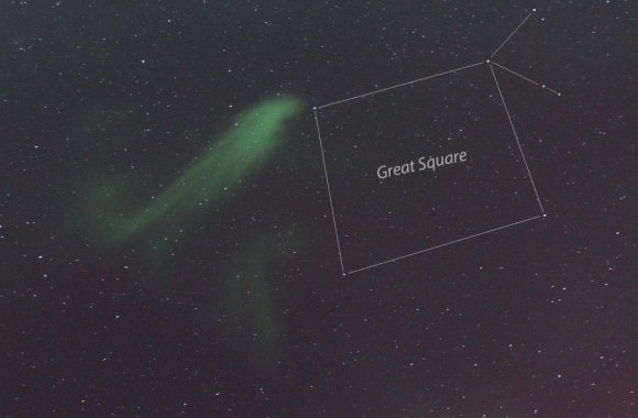
Opposite Cetus in the Aquila Milky Way, a huge ghostly patch resembling breath on a mirror lingered for some 20 minutes before fading away. Credit: Bob KingThis comet-like wisp next to Alpha Andromeda east of the Square of Pegasus appeared to flutter in the wind as it constantly dimmed, brightened and shape-shifted. Click photo to learn more about when to expect the next auroral display. Credit: Bob KingFinally – a mighty show of rays around 3 a.m. this morning. What you don’t see in the photo are the rhythmic pulsations fluttering through the entire display, a phenomenon known as “flaming”. Credit: Bob King
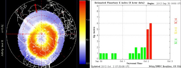
Magnetic and auroral activity indicators shot up to high levels last night and this morning. Left image from the POES satellite shows the extent of the auroral oval shortly after midnight CDT. At right, the Kp index shot up to 6 – a G2 or moderate geomagnetic storm – by the early morning. Click to see the current oval. Credit: NOAA
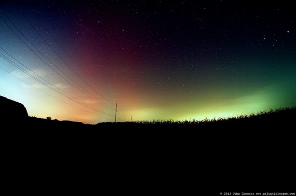
UPDATE: Other astrophotographers in the US also were able to capture some aurora images. John Chumack, whose images we frequently feature here on UT got this shot early on the morning of October 2:
Aurora Borealis, ‘The Northern Lights, as seen near Dayton, Ohio on October 2, 2013. Credit and copyright: John Chumack/Galactic Images.
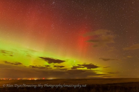
And Alan Dyer in Canada got this amazing “fiery” shot:
A red and green aurora, from southern Alberta, Canada on Oct 1, 2013. Credit and copyright: Alan Dyer/Amazing Sky Photography.
This timelapse from Arthur, Ontario was shot on Oct. 2 as well:
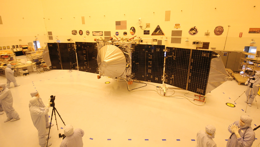
The upcoming Nov. 18 blastoff of NASA’s new MAVEN Mars orbiter is threatened by the today’s US Federal Government shutdown. Launch processing work has now ceased! Spacecraft preps had been in full swing when MAVEN was unveiled to the media, including Universe Today, inside the cleanroom at the Kennedy Space Center on Sept. 27, 2013. Credit: Ken Kremer/kenkremer.com
The upcoming Nov. 18 blastoff of NASA’s new MAVEN Mars orbiter is threatened by today’s US Federal Government shutdown. Launch processing work has now ceased! Spacecraft preps had been in full swing when MAVEN was unveiled to the media, including Universe Today, inside the clean room at the Kennedy Space Center on Sept. 27, 2013. With solar panels unfurled, this is exactly how MAVEN looks when flying through interplanetary space and orbiting Mars.
Credit: Ken Kremer/kenkremer.com[/caption]
KENNEDY SPACE CENTER, FL – The upcoming Nov. 18 blastoff of NASA’s next mission to Mars – the “breathtakingly beautiful” MAVEN orbiter – is threatened by today’s (Oct. 1) shutdown of the US Federal Government. And the team is very “concerned”, although not yet “panicked.”
MAVEN’s on time launch is endangered by the endless political infighting in Washington DC. And the bitter gridlock could cost taxpayers tens of millions of dollars or more on this mission alone!
Why? Because launch preparations at NASA’s Kennedy Space Center (KSC) have ceased today when workers were ordered to stay home, said the missions top scientist in an exclusive to Universe Today.
“MAVEN is shut down right now!” Prof. Bruce Jakosky, MAVEN’s principal Investigator, of the University of Colorado at Boulder, told Universe Today in an exclusive post shutdown update today.
“Which means that civil servants and work at government facilities [including KSC] have been undergoing an orderly shutdown,” Jakosky told me.
The nominal interplanetary launch window for NASA’s $650 Million MAVEN (Mars Atmosphere and Volatile EvolutioN Mission) mission to study the Red Planet’s upper atmosphere only extends about three weeks until Dec. 7.
If MAVEN misses the window of opportunity this year, liftoff atop the Atlas V rocket would have to be postponed until early 2016 because the Earth and Mars only align favorably for launches every 26 months.
Any launch delay could potentially add upwards of tens to hundreds of millions of dollars in unbudgeted costs to maintain the spacecraft and rocket – and that’s money that NASA absolutely does not have in these fiscally austere times.
MAVEN spacecraft preps for Nov. 18 launch to Mars were on schedule when it was unveiled to the media inside the clean room at the Kennedy Space Center on Sept. 27, 2013. The Oct. 1 US Government shutdown has stopped all work. Credit: Ken Kremer/kenkremer.com
MAVEN and much of NASA are not considered “essential” – despite having responsibility for hundreds of ongoing mission operations costing tens of billions of dollars that benefit society here on Earth. So about 97% of NASA employees were furloughed today.
What’s happening with the spacecraft right now?
“The hardware is being safed, meaning that it will be put into a known, stable, and safe state,” Jakosky elaborated.
Team members say there are about nine days of margin built into the processing schedule, which still includes fueling the spacecraft.
“We’ll turn back on when told that we can. We have some margin days built into our schedule,” Jakosky told me.
“We’re just inside of 7 weeks to launch, and every day is precious, so we’re certainly as anxious as possible to get back to work as quickly as possible.
And he said the team will do whatever necessary, including overtime, to launch MAVEN to the Red Planet by Dec. 7.
“The team is committed to getting to the launch pad at this opportunity, and is willing to work double shifts and seven days a week if necessary. That plus the existing margin gives us some flexibility. “
“That’s why I’m concerned but not yet panicked at this point.”
But a lengthy delay would by problematical.
“If we’re shut down for a week or more, the situation gets much more serious,” Jakosky stated.
Until today, all of the spacecraft and launch preparations had been in full swing and on target – since it arrived on Aug. 2 after a cross country flight from the Colorado assembly facility of prime contractor Lockheed Martin.
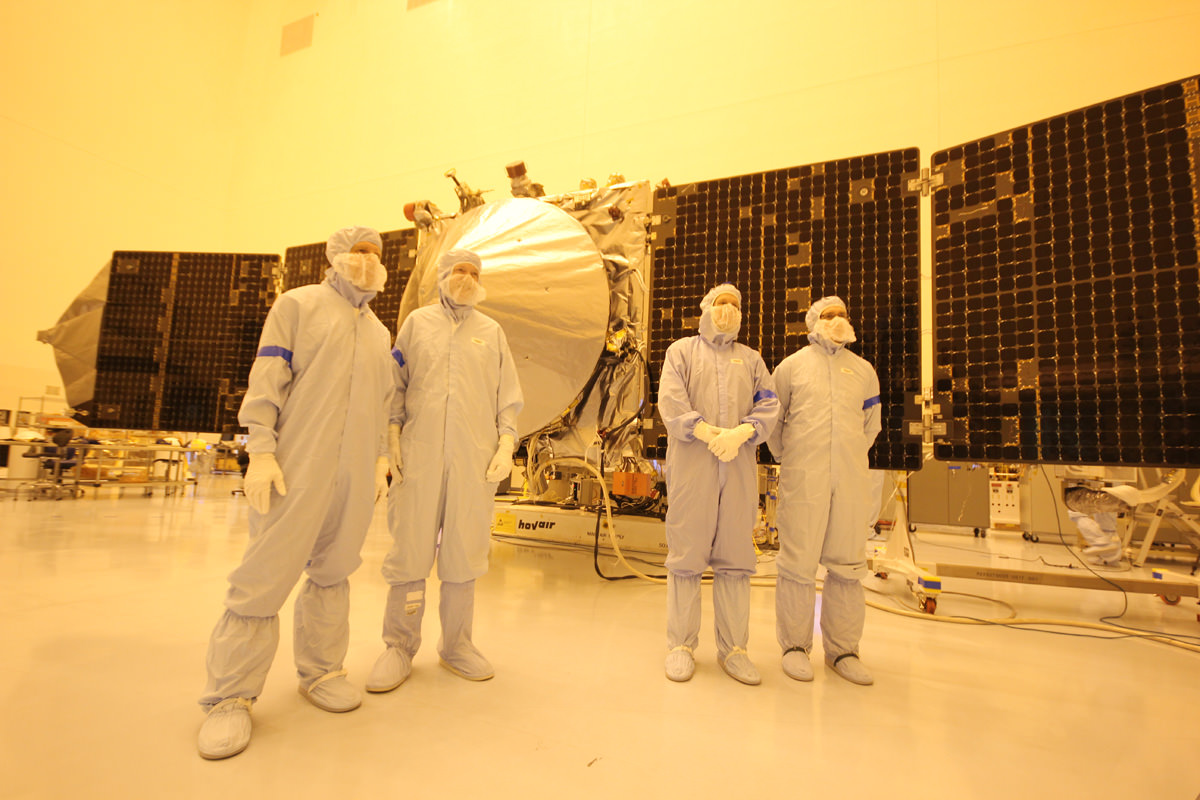
Indeed it was all smiles and thumbs up when I was privileged to personally inspect MAVEN inside the clean room at KSC a few days ago on Friday, Sept 27 during a media photo opportunity day held for fellow journalists.
Until now, “MAVEN was on schedule and under budget” said Jakosky in an interview as we stood a few feet from the nearly fully assembled spacecraft.
See my MAVEN clean room photos herein.
NASA’s MAVEN Mars orbiter, chief scientist Prof. Bruce Jakosky of CU-Boulder and Ken Kremer of Universe Today inside the clean room at the Kennedy Space Center on sept 27, 2013. MAVEN was due to launch to Mars on Nov. 18, 2013 from Florida – before the Oct. 1 government shutdown derailed plans. Credit: Ken Kremer/kenkremer.com
And in an ultra rare viewing opportunity, the solar panels were fully unfurled.
“The solar panels look exactly as they will be when MAVEN is flying in space and around Mars.”
“To be here with MAVEN is breathtaking,” Jakosky told me. “
“Its laid out in a way that was spectacular to see!”
Magnetometer science instrument juts out from MAVEN solar panel during launch processing inside the clean room at the Kennedy Space Center. Credit: Ken Kremer/kenkremer.com
If absolutely necessary it might be possible to extend the launch window a little bit beyond Dec. 7, but its uncertain and would require precise new calculations of fuel margins.
“The nominal 20-day launch period doesn’t take into account the fact that our actual mass is less than the maximum allowable mass,” Jakosky explained.
“The last day we can launch has some uncertainty, because it also requires enough fuel to get into orbit before our mission would begin to be degraded.”
MAVEN team members, including chief scientist Bruce Jakosky (2nd from left) pose with spacecraft inside the clean room at the Kennedy Space Center on Sept. 27, 2013. Credit: Ken Kremer/kenkremer.com
It sure was breathtaking for me and all the media to stand beside America’s next Mission to Mars. And to contemplate it’s never before attempted science purpose.
“MAVENS’s goal is determining the composition of the ancient Martian atmosphere and when it was lost, where did all the water go and how and when was it lost,” said Jakosky.
That’s the key to understanding when and for how long Mars was much more Earth-like compared to today’s desiccated Red Planet.
Following a 10 month interplanetary voyage, MAVEN would fire thrusters and brake into Mars orbit in September 2014, joining NASA’s Red Planet armada comprising Curiosity, Opportunity, Mars Odyssey and Mars Reconnaissance Orbiter.
Lets all hope and pray for a short government shutdown – but the outlook is not promising at this time.
Learn more about MAVEN, Curiosity, Mars rovers, Cygnus, Antares, SpaceX, Orion, LADEE, the Govt shutdown and more at Ken’s upcoming presentations
Oct 3: “Curiosity, MAVEN and the Search for Life on Mars – (3-D)”, STAR Astronomy Club, Brookdale Community College & Monmouth Museum, Lincroft, NJ, 8 PM
Oct 8: NASA’s Historic LADEE Lunar & Antares/Cygnus ISS Rocket Launches from Virginia”; Princeton University, Amateur Astronomers Assoc of Princeton (AAAP), Princeton, NJ, 8 PM
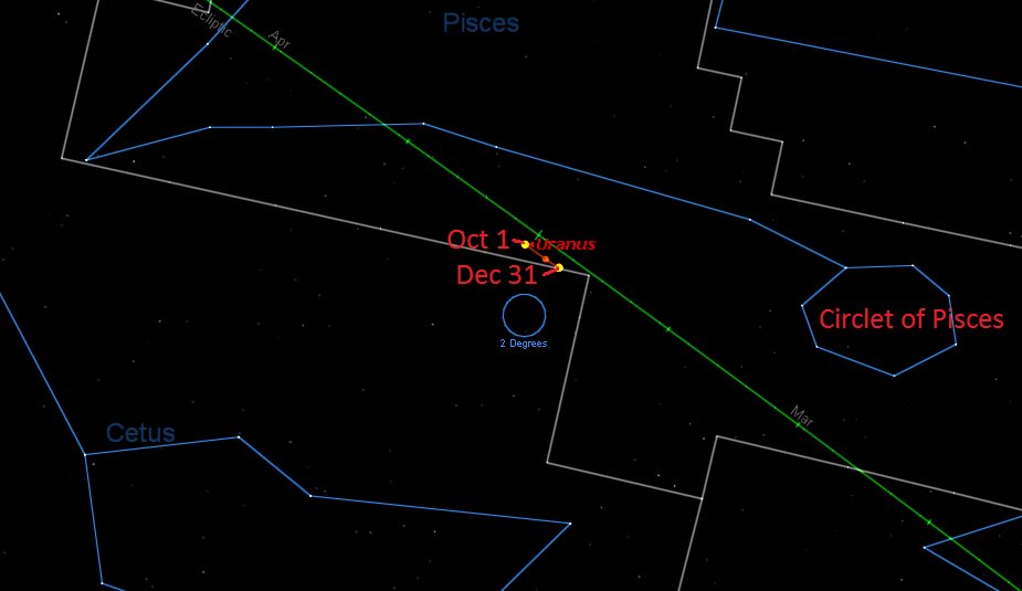
Up for a challenge? Got a big 12” light bucket of a Dobsonian telescope and looking for something new to point it at? This week, as the Moon reaches New phase on October 4th and stays safely out of the late evening sky, why not check out Uranus and its retinue of moons. And yes, we’ve heard just about ALL the Uranus jokes —its pronouncedyer-in-us, thank you very much — but feel free to attempt to pen an original if you must.
Now, back to astronomy. Uranus reaches opposition for 2013 on Thursday, October 3rd at 14:00 Universal Time. Opposition is the point in time that an outer planet rises as the Sun sets. In the case of Uranus, its opposition dates advance forward by about 4-5 days each year.
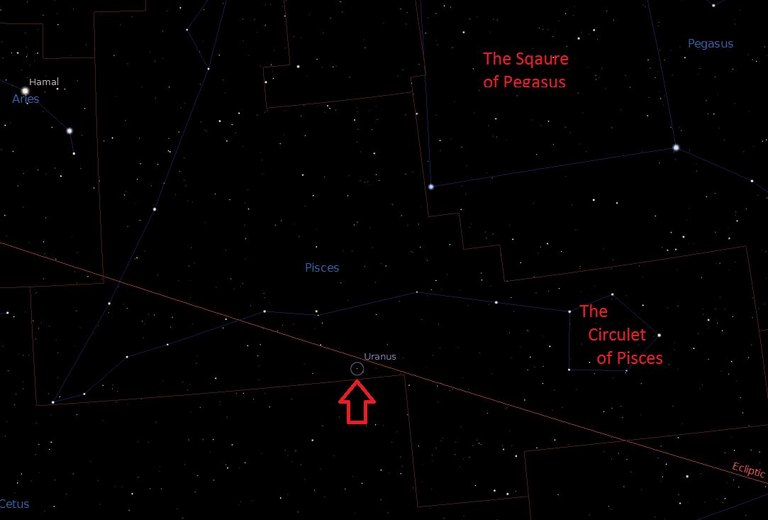
The current location of Uranus in Pisces. Created by the author using Stellarium. (click to enlarge).
This also marks the start of the best time to hunt for the planet among the star fields of the constellation Pisces. Uranus will reach its maximum elevation above the southern horizon for northern hemisphere viewers for early October around local midnight. For observers south of the equator, Uranus will transit to the north. Incidentally, Uranus also currently sits near the equinoctial point occupied by the Sun during the March equinox, making viewing opportunities nearly equal for both hemispheres.
Uranus is 19.04 astronomical units distant during opposition 2013, or about 158 light minutes away. Shining at magnitude +5.8, Uranus presents a tiny blue-green disk just under 4” across at opposition.
Uranus currently lies six degrees SW of the +4.4 magnitude star Delta Piscium, on the border of the constellations Pisces and Cetus. Uranus will actually be crossing once again into the non-zodiacal constellation of Cetus later this year.
Discovered in 1781 by Sir William Herschel, Uranus has only completed 2 full orbits (2.75 to be precise) in its 84.3 year trips about the Sun. We can be thankful that William’s proposal to name the planet Geogium Sidus after his benefactor King George the III didn’t stick!
The path of Uranus into Cetus. Created by the author using Starry Night Education software.
At opposition, Uranus will be located at;
Right Ascension: 0h 40’
Declination: +3° 25’
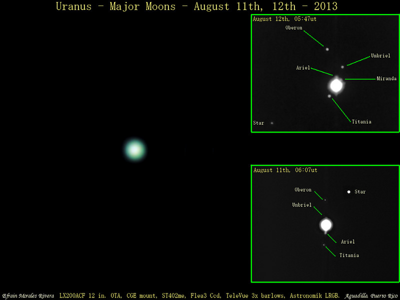
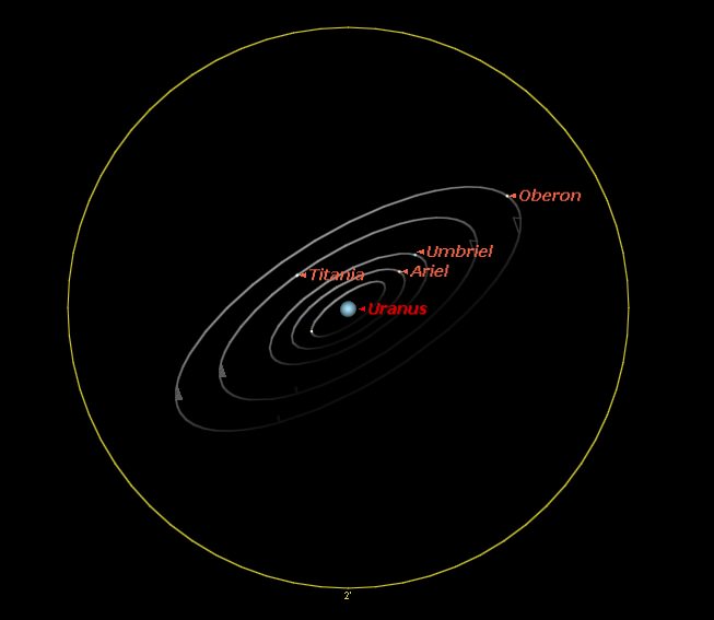
Five of the 27 known moons of Uranus are also within the grasp of a moderate-sized backyard scope as well. The trick is to catch ‘em near greatest elongation, when they appear farthest from the “glare of Uranus” (hey, there’s a freebie for a snicker or two). An eyepiece equipped with an occulting bar, or simply nudging Uranus out of the field of view can also help.
With magnitudes ranging from +13 to +16, the moons of Uranus are similar in brightness to Neptune’s large moon Triton or the tiny world Pluto.
The five brightest moons of Uranus and their respective maximum elongations are:
Chart constructed by author.
And here’s a handy finder chart for the coming month, showing maximum elongations for each:
A corkscrew graph featuring the greatest elongations for the five brightest moons of Uranus through October. (Created by Ed Kotapish using PDS Rings Node).
The first two moons were named Titania and Oberon by William’s son John after characters from William Shakespeare’s A Mid-Summer Night’s Dream. William discovered the first two moons of Uranus on the night of January 11th, 1787 using his 49.5” reflector. His scopes were so advanced for his day, that it wasn’t until over a half a century later that William Lassell discovered Umbriel and Ariel using the Liverpool Observatory’s 24” reflector in 1851.
Gerard Kuiper would later add tiny Miranda to the list, nabbing it with the McDonald Observatory’s 82” Otto Struve Telescope in 1948. We would then have to wait until Voyager 2’s 1986 flyby of Uranus in 1986 to add more. To date, Voyager 2 remains the only spacecraft to visit Uranus and Neptune.
The current convention established by the International Astronomical Union is to name the moons of Uranus after characters from the plays of Shakespeare or Alexander Pope’s Rape of the Lock.
There’s still a wide range of names in said literature to choose from!
It’s interesting to note that the orbits of the moons of Uranus are also currently tipped open about 25 degrees to our line of sight and widening. They were edge on in December 2007, and will be perpendicular to our Earthly view come 2029, after which they’ll head back to edge on in 2049. This is because Uranus and the orbits of its moons are tipped at a 97 degree angle relative to the planet’s orbit. This is why elongations for its moons are often quoted it terms of “north and south” of the planet, rather than the familiar east and west. Shadow transits of the moons can occur with about a year and a half during plane-crossing seasons, but they’re ~42 years apart and tough to spot on the tiny disk of Uranus!
An example of the orientation of Uranus’s moons on October 4th, with Oberon at greatest elongation. Note that Miranda is the tiny unlabeled moon with the interior orbit. (Created by the author using Starry Night Education software).
Uranus also reached aphelion in 2009 at 20.099 AU from the Sun —we’re still at the farther end of the spectrum, as oppositions of Uranus can range from 19.09 to 17.28 AU distant.
Uranus will rise earlier on each successive evening until it reaches quadrature at the end of the year on December 30th. At this point, it’ll be roughly due south at local sunset. Keep in mind, there’s also another ice giant worth hunting for in the adjacent constellation of Aquarius named Neptune.
So ignore those bad puns, and be sure to take out that 10” (scope, that is) and point it at Uranus!
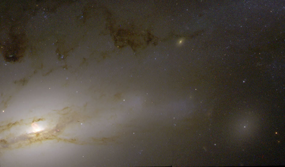
A quasar resides in the hub of the nearby galaxy NGC 4438. Credit: NASA/ESA, Jeffrey Kenney (Yale University), Elizabeth Yale (Yale University)
50 million light-years away a quasar resides in the hub of galaxy NGC 4438, an incredibly bright source of light and radiation that’s the result of a supermassive black hole actively feeding on nearby gas and dust (and pretty much anything else that ventures too closely.) Shining with the energy of 1,000 Milky Ways, this quasar — and others like it — are the brightest objects in the visible Universe… so bright, in fact, that they are used as beacons for interplanetary navigation by various exploration spacecraft.
“I must go down to the seas again, to the lonely sea and the sky,
And all I ask is a tall ship and a star to steer her by.”
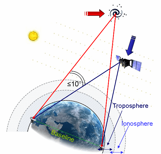
Deep-space missions require precise navigation, especially when approaching bodies such as Mars, Venus, or comets. It’s often necessary to pinpoint a spacecraft traveling 100 million km from Earth to within just 1 km. To achieve this level of accuracy, experts use quasars – the most luminous objects known in the Universe – as beacons in a technique known as Delta-Differential One-Way Ranging, or delta-DOR.
How delta-DOR works (ESA)
Delta-DOR uses two antennas in distant locations on Earth (such as Goldstone in California and Canberra in Australia) to simultaneously track a transmitting spacecraft in order to measure the time difference (delay) between signals arriving at the two stations.
Unfortunately the delay can be affected by several sources of error, such as the radio waves traveling through the troposphere, ionosphere, and solar plasma, as well as clock instabilities at the ground stations.
Delta-DOR corrects these errors by tracking a quasar that is located near the spacecraft for calibration — usually within ten degrees. The chosen quasar’s direction is already known extremely well through astronomical measurements, typically to closer than 50 billionths of a degree (one nanoradian, or 0.208533 milliarcsecond). The delay time of the quasar is subtracted from that of the spacecraft’s, providing the delta-DOR measurement and allowing for amazingly high-precision navigation across long distances.
“Quasar locations define a reference system. They enable engineers to improve the precision of the measurements taken by ground stations and improve the accuracy of the direction to the spacecraft to an order of a millionth of a degree.”
– Frank Budnik, ESA flight dynamics expert
So even though the quasar in NGC 4438 is located 50 million light-years from Earth, it can help engineers position a spacecraft located 100 million kilometers away to an accuracy of several hundred meters. Now that’s a star to steer her by!
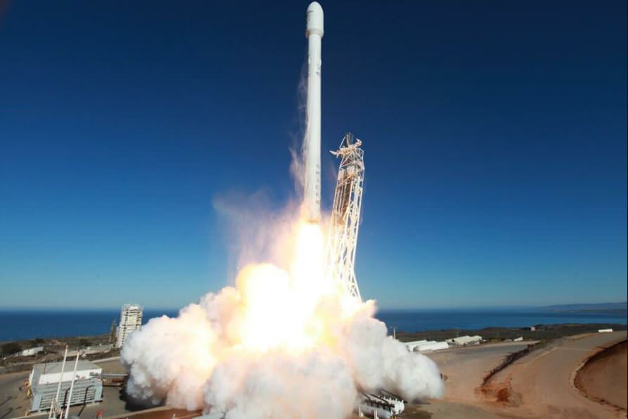
The launch of SpaceX's Falcon 9 v.1.1 rocket from Vandenberg Air Force Base in California on September 29, 2013. Credit: SpaceX.
When the US Space Surveillance Network indicated they were tracking additional objects in orbit following Sunday’s maiden launch of SpaceX’s next generation rocket, speculation began among satellite trackers that the upper stage of the Falcon 9 v1.1. rocket may have exploded. But SpaceX issued a statement today that their data indicates no such explosion occurred, and that insulation may have come off the second stage, creating extra objects.
Meanwhile, SpaceX CEO Elon Musk confirmed via Twitter that reports of a “fuzzy” UFO over South Africa following the launch came from liquid oxygen released by the Falcon 9 rocket’s second stage.
@DebbieViviers@SpaceX Yes, upper stage venting of liquid oxygen created a fast moving fuzzy white sphere in space over SA
In the September 29 launch from Vandenberg Air Force Base in California, SpaceX successfully launched and deployed the Canadian Space Agency’s CASSIOPE weather satellite (Cascade, Smallsat, and Ionospheric Polar Explorer) and six additional small satellites.
SpaceTrack was tracking 20 objects from the launch, but only fourteen should have been in orbit (CASSIOPE, 6 small sats, 4 spacers from the POPACS satellite trio, the second stage and two fairings) leaving ssix objects unaccounted for.
“Regarding the rumors you may have heard about the Falcon 9 second stage, in short, our data confirms there was no rupture of any kind on the second stage,” SpaceX spokeswoman Emily Shanklin wrote in an email on October 1.
SpaceX gave this account of what likely happened after launch:
Following separation of the satellites to their correct orbit, the Falcon 9 second stage underwent a controlled venting of propellants (fuel and pressure were released from the tank) and the stage was successfully safed. During this process, it is possible insulation came off the fuel dome on the second stage and is the source of what some observers incorrectly interpreted as a rupture in the second stage. This material would be in several pieces and be reflective in the Space Track radar. It is also possible the debris came from the student satellite separation mechanisms onboard.
The new, more powerful version of the Falcon 9 is powered by a cluster of nine of the new Merlin 1D engines that are about 50% more powerful compared to the standard Merlin 1C engines and can therefore boost a much heavier cargo load to the ISS and beyond. The Falcon 9 v.1.1 is taller than a standard Falcon 9: about 22 stories high vs. 13.
Musk told reporters at a post-launch news conference that they attempted to reignite the upper stage after payload separation for demonstrating the capability of putting satellites into a geostationary transfer orbit. However, the reignition sequence was aborted after a problem was detected.
Several images and videos were posted online of a UFO seen over South Africa, Madagascar, Botswana, and Malawi. But it was quickly determined to be a cloud of rocket propellant surrounding the spent Falcon 9 upper stage.
SpaceX said they will continue to review their data to help identify the source of the extra debris.
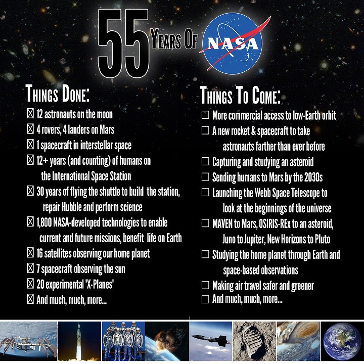
Before having to close the door (temporarily) today, NASA put together this nice graphic of the highlights of their accomplishments of the past 55 years, as well as what the hopes and plans are for the future.
The National Aeronautics and Space Administration began operating on October 1, 1958, managing the US’s burgeoning space exploration program. NASA replaced the National Advisory Committee for Aeronautics (NACA) agency, which began in 1915 to undertake and promote aeronautical research.
Now, NASA is in the midst of expanding commercial access to the International Space Station with the rendezvous of Orbital Science’s Cygnus capsule this week. While the ISS is still operating, and when full operations resume throughout NASA, they’ll continue work on exploring space, monitoring Earth, unlocking mysteries of our solar system and peering back into the beginnings of the Universe.
Our advice to you? If you are a US citizen, write your Congress-people and tell them how important you feel NASA is to the future of the nation and the world. And while you’re at it, tell them to get to work and do the job they were elected to do. Find out who represents you in the US Congress here.
Artist's impression of how huge cosmic structures deflect photons in the cosmic microwave background (CMB). Credit: ESA and the Planck Collaboration
Leftover radiation from the Big Bang — that expansion that kick-started the universe — can be bent by huge cosmic structures, just like other light that we see in the universe. While the finding seems esoteric at first glance, scientists say the discovery could pave the way for finding a similar kind of signal that indicate the presence of gravitational waves in the moments after the universe was born.
That light is called the cosmic microwave background and is the radiation that was visible when the universe became transparent to radiation, 380,000 years after the Big Bang. A tiny bit of the CMB is polarized. There are two types of polarized light in the CMB: E-modes (first detected in 2002) and B-modes (which were just detected using a telescope in Antarctica and ESA’s Herschel space observatory.
“[B-modes] can arise in two ways,” the European Space Agency wrote in a press release.
“The first involves adding a twist to the light as it crosses the Universe and is deflected by galaxies and dark matter – a phenomenon known as gravitational lensing. The second has its roots buried deep in the mechanics of a very rapid phase of enormous expansion of the Universe, which cosmologists believe happened just a tiny fraction of a second after the Big Bang – ‘inflation’.”
More results are on the way from ESA’s Planck telescope in 2014, at which point scientists hope to see this B-mode of the second type. For now, check out the full study in Physical Review Letters. There is also a preprint version available on Arxiv.
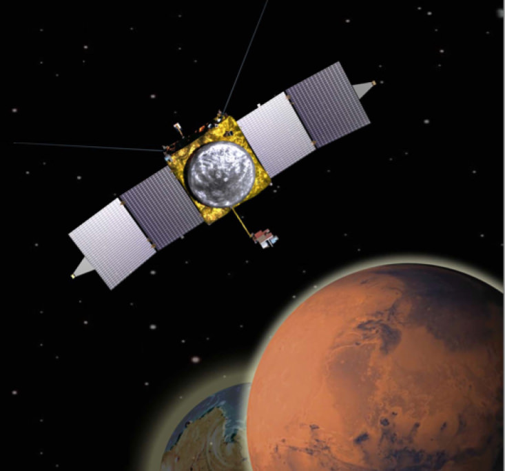
The MAVEN missions ‘Going to Mars’ campaign invites the public to submit names and poems which will be included on a special DVD. The DVD will be adhered to the MAVEN spacecraft and launched to Mars on Nov. 18, 2013. Credit: NASA/GSFC
A forthcoming NASA launch to Mars could be in danger of losing its launch window should a shutdown in the United States federal government that began today (Oct. 1) continue for a while. That’s just one of the ways in which NASA is affected amid a lapse of funding that is affecting all government agencies and an untold number of government contractors.
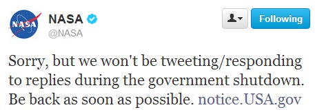
Around 97% of NASA’s 18,000 employees are off the job. Twitter, Facebook, Google Plus and other social media accounts are going dark. NASA’s website is being pulled offline. NASA Television has also ceased broadcasting.
Beyond the agency’s public face, activities ranging from certain commercial crew payouts, to conference attendance, to scientific work will cease. Awards and scholarship approvals will be delayed.
“NASA will shut down almost entirely,” said President Barack Obama in a speech late Monday (Sept. 30).
In addition to the agency’s public relations activities, NASA is planning to launch the Mars Atmosphere and Volatile EvolutioN (MAVEN) spacecraft to Mars in November to examine the Red Planet’s atmosphere. There are all sorts of questions vexing scientists concerning that planet, with one of the most prominent ones being why the atmosphere thinned over the years.
Media reports indicate that if the shutdown is lengthy, MAVEN could miss the launch window and have to try again in 2016.
“A shutdown could delay the pre-launch processing currently under way with a possible impact to the scheduled Nov. 18 launch date,” Dwayne Brown, a NASA senior public affairs officer at NASA, told The Planetary Society in a story published yesterday (Sept. 30). The launch window extends for several weeks beyond that time, however.
The 3% of NASA employees who are deemed essential will work without pay until the situation is resolved. These are some of the things that will continue:
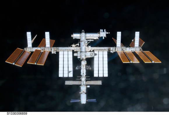
The International Space Station. Credit: NASA
International Space Station monitoring will be maintained, but with the bare minimum of ground crew. (NASA will cease regular updates of the astronauts’ activities during the furlough, although we presume if something urgent happened there would be an update.)
Robotic missions that are already in operation — think the Cassini spacecraft circling Saturn, or the Lunar Atmosphere and Dust Environment Explorer (LADEE) winging its way to the moon — will have small crews making sure that they are functioning properly. No scientific analysis will be conducted, though.
Certain other programs will continue if a shutdown would be detrimental to their performance. Space News reports that the much-delayed James Webb Space Telescope will be among them, as some of its instruments are undergoing cryogenic vacuum testing at the Goddard Space Flight Center.
Update, 1:09 p.m. EDT: Several missions run out of the Jet Propulsion Laboratory and Applied Physics Laboratory are running as usual for at least the next week because these facilities are running under contracted money from NASA and still have funds in the bank. According to the Planetary Society’s Emily Lakdawalla: “At JPL, that includes: Curiosity; Opportunity; Odyssey; Mars Reconnaissance Orbiter; Cassini; Dawn; Juno; Spitzer; the Voyagers; and WISE, among many others. At APL, that includes MESSENGER and New Horizons. It also includes the Deep Space Network.”
Additional Update, 2:09 p.m. EDT: The HiRISE twitter account just replied to inquiries from several space journalists that they will be “open for business” as usual, which is great news since the Mars Reconnaissance Orbiter made an audacious attempt to take images of Comet ISON during the comet’s closest approach to Mars today. We’ll provide any news and updates on images as they become available, but the HiRISE team said getting the images back to Earth and processing them may take a day or two.
HiRISE is still open for business and updates will continue as usual.
Many observers noted that NASA is marking its 55th anniversary today by shutting down its activities. There’s no word yet on when the deadlock in Congress will be resolved. The last two shutdowns in 1995 and 1996 (which began in the middle of the STS-74 shuttle mission to Mir) lasted several weeks.
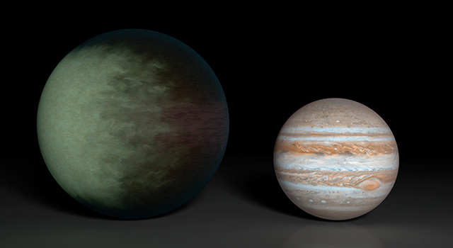
Cloud map of Kepler-7b (left) in comparison to Jupiter (right). Credit: NASA/JPL-Caltech/MIT
Call it cloudy with a low chance of meatballs. The alien world Kepler-7b — a very reflective world in big telescopes — has clouds in its upper atmosphere. And scientists have actually been able to map those out, despite the planet’s great distance from Earth (at least 1,000 light-years away.)
It’s the first time scientists have been able to map out clouds on a world outside of the solar system. If we can see clouds, then we can begin to think about what a planet’s climate will be, making this an important milestone in understanding the conditions on other worlds.
“Kepler-7b reflects much more light than most giant planets we’ve found, which we attribute to clouds in the upper atmosphere,” stated Thomas Barclay, Kepler scientist at NASA’s Ames Research Center. “Unlike those on Earth, the cloud patterns on this planet do not seem to change much over time — it has a remarkably stable climate.”
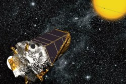
Illustration of the Kepler spacecraft (NASA/Kepler mission/Wendy Stenzel)
Here’s how scientists got it done:
Preliminary observations with the Kepler space telescope –which was designed to hunt planets until a second reaction wheel failed earlier this year — found “moon-like phases” on Kepler-7b. These showed a bright spot on the western hemisphere.
NASA’s Spitzer Space Telescope measured Kepler-7b’s temperature using infrared light, calculating it at between 1,500 and 1,800 degrees Fahrenheit (815 and 982 degrees Celsius.)
Something was clearly going on, as the planet is extremely close to its star; only 0.06 Earth-sun distances away. The temperature was too cool. They figured out that the light was reflected off cloud tops on the planet’s west side.
Another cool fact — Kepler-7b, like Saturn, would float if it was put in a big enough tub of water!
You can read more details in the technical paper online here. The study, which was led by the Massachusetts Institute of Technology, has been accepted to the Astrophysical Journal, but not published yet.
And if you’re interested in looking back, here’s an archive to all the past Carnivals of Space. If you’ve got a space-related blog, you should really join the carnival. Just email an entry to [email protected], and the next host will link to it. It will help get awareness out there about your writing, help you meet others in the space community – and community is what blogging is all about. And if you really want to help out, sign up to be a host. Send an email to the above address.