Remembering the Great Meteor Procession of 1860

Painting of The Meteor of 1860 by Hudson River School artist Frederic Church. (Credit: Frederic Church courtesy of Judith Filenbaum Hernstadt).

“Year of meteors! Brooding year!”

 -Walt Whitman

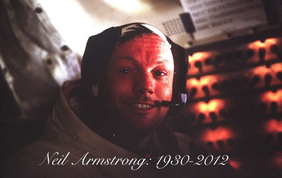
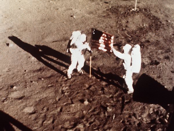
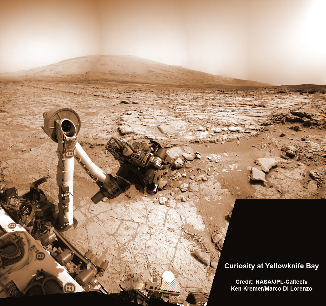
July 20th is a red letter date in space history. Apollo 11, the first crewed landing on the Moon, took place on this day in 1969. Viking 1 also made the first successful landing on Mars, seven years later to the day in 1976.

A remarkable astronomical event also occurred over the northeastern United States 153 years ago today on the night of July 20th, known as the Great Meteor Procession of 1860. And with it came a mystery of poetry, art and astronomy that was only recently solved in 2010.

A meteor procession occurs when an incoming meteor breaks up upon reentry into our atmosphere at an oblique angle. The result can be a spectacular display, leaving a brilliant glowing train in its wake. Unlike early morning meteors that are more frequent and run into the Earth head-on as it plows along in its orbit, evening meteors are rarer and have to approach the Earth from behind. In contrast, these often leave slow and stately trains as they move across the evening sky, struggling to keep up with the Earth.

The Great Meteor Procession of 1860 also became the key to unlock a 19th century puzzle as well. In 2010, researchers from Texas University San Marcos linked the event to the writings of one of the greatest American poets of the day.

Whitman...
Photograph of Walt Whitman taken by Mathew Brady circa 1860 (Library of Congress image in the Public Domain)..

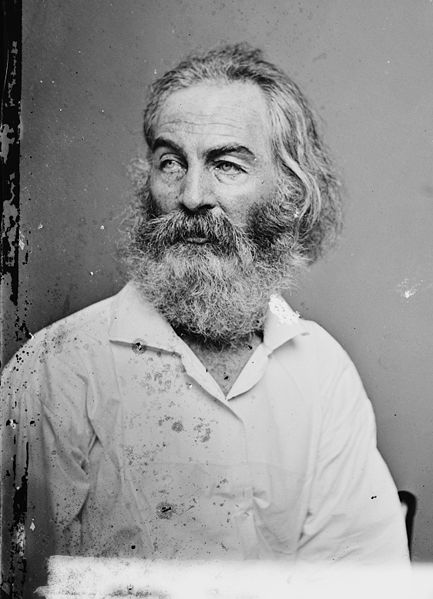
Walt Whitman described a “strange, huge meteor-procession” in a poem entitled “Year of Meteors (1859-60)” published in his landmark work Leaves of Grass.

English professor Marilynn S. Olson and student Ava G. Pope teamed up with Texas state physics professors Russell Doescher & Donald Olsen to publish their findings in the July 2010 issue of Sky & Telescope.

As a seasoned observer, Whitman had touched on the astronomical in his writings before.

The event had previously been attributed over the years to the Great Leonid Storm of 1833, which a young Whitman would’ve witnessed as a teenager working in Brooklyn, New York as a printer’s apprentice.

Researchers noted, however, some problems with this assertion.

The stanza of contention reads;

Nor forget I sing of the wonder, the ship as she swam up my bay,

Well-shaped and stately, the Great Eastern swam up my bay, she was 600 feet long,

Her moving swiftly surrounded by myriads of small craft I forget not to sing;

Nor the comet that came unannounced out of the north flaring in heaven,

Nor the strange huge meteor-procession dazzling and clear shooting over our heads.

(A moment, a moment long, it sail’d its balls of earthly light over our heads,

Then departed, dropt in the night, and was gone.)

In the poem, the sage refers to the arrival of the Prince of Wales in New York City on October 1860. The election of Abraham Lincoln in November of that same year is also referred to earlier in the work.  Whitman almost seems to be making a cosmic connection similar to Shakespeare’s along the lines of “When beggars die, no comets are seen…

Path of the Meteor Procession of 1860 as depicted in the newspapers of the day. (From the collection of Don Olson).

The “comet that came unannounced” is easily identified as the Great Comet of 1860. Also referred to as Comet 1860 III, this comet was discovered on June 18th of that year and reached +1st magnitude that summer as it headed southward. The late 19th century was rife with “great comets,” and northern hemisphere observers could look forward to another great cometary showing on the very next year in 1861.

The Great Comet of 1861 as drawn by G. Williams on June 30th, 1861. (From Descriptive Astronomy by George Chambers, 1877)

There are some problems, however with the tenuous connection between the stanza and the Leonids.

The 1833 Leonids were one of the most phenomenal astronomical events ever witnessed, with estimates of thousands of meteors per second being seen up and down the U.S. Eastern Seaboard the morning of November 13th. Whitman himself described the event as producing;

“…myriads in all directions, some with long shining white trains, some falling over each other like falling water…”

Keep in mind, many startled townsfolk assumed their village was on fire on that terrifying morning in 1833, as Leonid bolides cast moving shadows into pre-dawn bedrooms. Churches filled up, as many thought that Judgment Day was nigh. The 1833 Leonids may have even played a factor in sparking many of the religious fundamentalist movements of the 1830s. We witnessed the 1998 Leonids from Kuwait, and can agree that this meteor shower can be a stunning sight at its peak.

But Whitman’s poem describes a singular event, a “meteor-procession” very different from a meteor shower.

Various sources have tried over the years to link the stanza to a return of the Leonids in 1858. A note from Whitman mentions a “meteor-shower, wondrous and dazzling (on the) 12th-13th, 11th month, year 58 of the States…” but keep in mind, “year 1” by this reckoning is 1776.

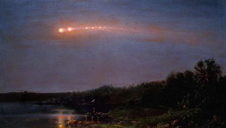
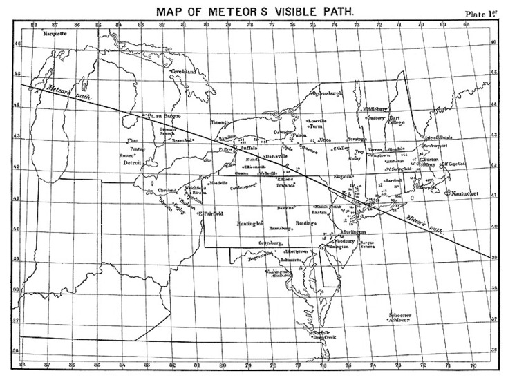
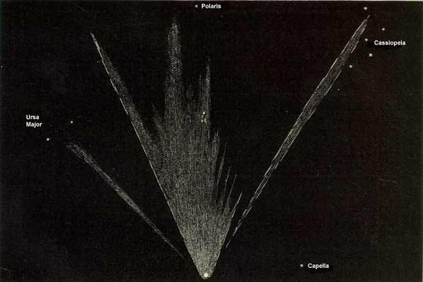
A lucky break came for researchers via the discovery of a painting by Frederic Church entitled “The Meteor of 1860.” This painting and several newspaper articles of the day, including an entry in the Harpers Weekly, collaborate a bright meteor procession seen across the northeastern U.S. from New York and Pennsylvania across to Wisconsin.

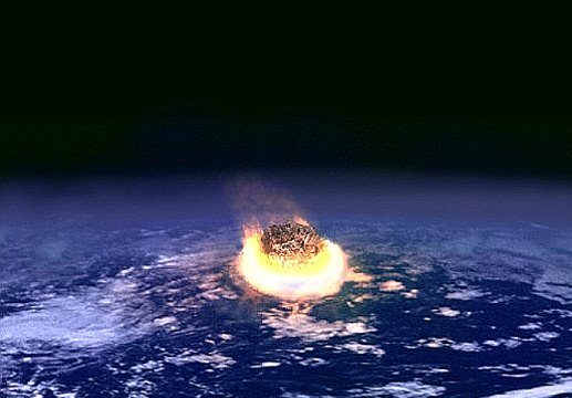
Such a bright meteor entered the atmosphere at a shallow angle, fragmented, and most likely skipped back out into space. Similar meteor processions have been observed over the years over the English Channel on August 18th, 1783 & across the U.S. Eastern Seaboard and Canada on February 9th, 1913.

On August 10th, 1972, a similar bright daylight fireball was recorded over the Grand Tetons in the western United States. Had the Great Meteor Procession of 1860 come in at a slightly sharper angle, it may have triggered a powerful airburst such as witnessed earlier this year over Chelyabinsk, Russia the day after Valentine’s Day.

The 1860 Meteor Procession is a great tale of art, astronomy, and mystery. Kudos to the team of researchers who sleuthed out this astronomical mystery… I wonder how many other unknown stories of historical astronomy are out there, waiting to be told?

Weekly Space Hangout – July 19, 2013

Here’s our Weekly Space Hangout for July 19, 2013. Watch as a team of space and astronomy journalists discuss the big space stories of the week. We do this every Friday at 12:00 pm Pacific Time / 3:00 pm Eastern Time. You can join us live, or watch the archive here or on Google+.

Host: Fraser Cain

Participants: Sondy Springmann, Amy Shira Teitel, Jason Major, David Dickenson, Dr. Matthew Francis

And here are the stories that we covered.

Apollo 11 F-1 Engine Finding Confirmed by Jeff Bezos on Eve of 1st Human Moonwalk

Saturn V Moon Rocket F-1 Engine Thrust Chamber recovered from the floor of the Atlantic Ocean. Credit: Jeff Bezos Expeditions

In a fitting testament to NASA’s momentous Apollo Moon Landing Program, NASA and billionaire Jeff Bezos confirmed today (July 19) the discovery of a powerful F-1 first stage engine component from the Saturn V moon rocket that launched three American astronauts on the historic journey of Apollo 11 to land the first two humans on the Moon on July 20, 1969.

“On the eve of the 44th moonwalk anniversary, the Bezos Expedition confirms an Apollo 11 Saturn V F1 engine find,” NASA officially announced on its websites just moments ago today, July 19.

Apollo 11 commander and NASA astronaut Neil Armstrong, was immortalized forever when he first set foot on the moon 44 years ago tomorrow (July 20, 1969), followed minutes later by the lunar module pilot, NASA astronaut Buzz Aldrin.

The Saturn V rockets first stage was powered by a cluster of five F-1 engines – a technological marvel and the most powerful single-nozzle, liquid-fueled rocket engine ever developed.

“44 years ago tomorrow Neil Armstrong stepped onto the moon, and now we have recovered a critical technological marvel that made it all possible,” says Bezos on his Expedition website today.

Apollo 11 Saturn V F-1 Engine Thrust Chamber recovered from the floor of the Atlantic Ocean- stenciled with Rocketdyne serial number “2044”. Credit: Jeff Bezos Expeditions

Bezos, founder and Chief Executive Officer of the aerospace company Blue Origin and Amazon.com, originally announced the discovery and recovery of significant components of two flown F-1 engines amongst a field of twisted wreckage from the floor of the Atlantic Ocean in March of this year, aboard the Seabed Worker at Port Canaveral, Florida, along with a treasure trove of other major Saturn V components hauled up from a depth of almost 3 miles.

“We brought back thrust chambers, gas generators, injectors, heat exchangers, turbines, fuel manifolds and dozens of other artifacts – all simply gorgeous and a striking testament to the Apollo program,” wrote Bezos in a update this morning, July 19.

But until today, the engines exact identification remained elusive because of decades of severe seabed corrosion and their fiery, destructive end upon plunging and smashing unimpeded onto the ocean’s surface.

Saturn V F-1 Engine Nozzle recovered from the floor of the Atlantic Ocean. Credit: Jeff Bezos Expeditions
Saturn V F-1 Engine nozzle recovered from the floor of the Atlantic Ocean. Credit: Jeff Bezos Expeditions

Conservators from the Kansas Cosmosphere and Space Center in Hutchinson, Kansas worked painstakingly since March to identify the F-1 engine parts.

“Today, I’m thrilled to share some exciting news. One of the conservators who was scanning the objects with a black light and a special lens filter has made a breakthrough discovery – “2044” – stenciled in black paint on the side of one of the massive thrust chambers, says Bezos.

“2044 is the Rocketdyne serial number that correlates to NASA number 6044, which is the serial number for F-1 Engine #5 from Apollo 11. The intrepid conservator kept digging for more evidence, and after removing more corrosion at the base of the same thrust chamber, he found it – “Unit No 2044” – stamped into the metal surface.”

Blacklight ocean view of Saturn V F-1 Engine recovered from the floor of the Atlantic Ocean.   Credit: Jeff Bezos Expeditions
Blacklight view of Apollo 11 Saturn V F-1 Engine recovered from the floor of the Atlantic Ocean with identifying “2044” serial number. Credit: Jeff Bezos Expeditions

Apollo 11 launched to the Moon on July 16, 1969 from Launch Complex 39-A at the Kennedy Space Center in Florida.

Armstrong and Aldrin landed on the Sea of Tranquility inside the Lunar Module. They took a single lunar excursion and spent 2 hours and 11 minutes as the first two men to walk on the moon. They stayed on the moon for a total of 21 hours and 36 minutes before blasting off for the journey back home to Earth.

Armstrong suddenly passed away nearly a year ago on August 25, 2012 at age 82 – read my stories, here and here.

Aldrin is still active and strenuously advocating for starting human expeditions to the Red Planet.

He outlined his exploration concepts in a newly published book titled – “Mission to Mars.”

neil_bg_800

The five F-1 engines used in the 138-foot-tall Saturn V first stage known as the S-IC generated 7.5 million pounds of liftoff thrust, or some 1.5 million pounds each. They stand 19 feet tall by 12 feet wide. Each one weighs over 18,000 pounds and was manufactured by Rocketdyne.

The F-1 had more power than all three space shuttle main engines combined. They burned a mixture of liquid oxygen and kerosene fuel for two-and-one-half-minutes, carrying the Saturn V to an altitude of some 36 miles.

Altogether, six Apollo Moon landing flights boosted by Saturn V’s sent a total of 12 humans on moon walking expeditions to Earth’s nearest neighbor during the 1960s and 1970s.

“This is a big milestone for the project and the whole team couldn’t be more excited to share it with you all,” Bezos wrote.

Bezos’ Blue Origin firm is also working to develop a commercial rocket and ‘space taxi’ to finally resume launching American astronauts back to low Earth orbit from American soil after a multi year gap.

More than four decades have passed since the last humans traversed the lunar surface in December 1972 during NASA’s Apollo 17 moon landing mission.

After all that time, the F-1 may yet live again.

NASA is now working on an upgraded F-1 to power a future variant of the new SLS heavy lift booster under development and intended to launch humans aboard the new Orion crew capsule back to the Moon and to deep space destinations including Asteroids and Mars.

NASA’s robotic exploration of the moon continues this year with the blastoff of the LADEE Lunar observatory on Sept. 6 from NASA’s Wallops Island facility in Virginia.

Ken Kremer

Neil Armstrong and Buzz Aldrin plant the US flag on the Lunar Surface during 1st human moonwalk in history - exactly 44 years ago on July 20, 1969 during Apollo 1l mission. Credit: NASA
Neil Armstrong and Buzz Aldrin plant the US flag on the Lunar Surface during 1st human moonwalk in history – exactly 44 years ago on July 20, 1969 during Apollo 1l mission. Credit: NASA

Military Aurora Research Website Goes Dark As HAARP Facility Enters Contract Negotiations

This photo was taken on January 22, 2012 in Fairbanks North Star Borough County, Alaska, US, using a Nikon D5000. The explodey look is due to perspective from looking right up the magnetic field lines. The aurora in the middle of the explosion is pointing straight down at the camera. Credit: Jason Ahrns

A military program to investigate auroras in the north appears to have been suspended.

The High Frequency Active Auroral Research Program (HAARP)’s website (dead link here) is not available right now, and there’s been some media speculation about the program’s future. So far, though, our attempts to learn more about the situation have turned up little information.

“Currently the site is abandoned. It comes down to money. We don’t have any,” said James Keeney, who reportedly manages the HAARP project at Kirtland Air Force Base, in a report published by the American Radio Relay League earlier this week.

When Universe Today reached out to Keeney, however, he declined comment. We also got in touch with the public affairs officials at Kirtland Air Force Base, who said no one was immediately available for an interview and provided this statement:

A screenshot of Google Earth, with ionosphere overlayed (Google)

“HAARP is currently in contract negotiations and our policy is not to comment on current contract negotiations,” stated Marie M. Vanover, the director of Kirtland public affairs. “HAARP’s website is expected to be reopened and populated with the new and current information within 2-3 weeks.”

The program is jointly managed by the U.S. Air Force Research Laboratory and the U.S. Naval Research Laboratory to investigate activity in the ionosphere, the region of the Earth’s atmosphere where auroras occur. It includes an array of dozens of antennas that, media reports say, energize parts of the ionosphere.

HAARP is also the target of many conspiracy theories, ranging from warnings that it would trigger a change in the Earth’s magnetic poles to accusations that it is actually a weapon prototype. You can read more about the unproven allegations in this 2009 Wired article.

We’ll keep you posted on the facility’s status as we hear more.

Waltz Around Saturn With This Beautiful Animation

Just one of the many images from Cassini used to make up "Around Saturn"

In honor of this today’s Wave at Saturn and The Day the Earth Smiled events, celebrating images to be taken of Earth from Saturn, here’s a wonderful movie showing highlights from Cassini’s exploration of the giant planet, its magnificent rings, and fascinating family of moons.

Assembled by Fabio Di Donato in memory of astrophysicist, author and activist Margherita Hack, who passed away June 29 at the age of 91, this video is an impressive tour of the Saturnian system — and a truly stunning tribute as well.

“She made me love the stars,” Fabio wrote.

This video shows a selection from more than 200,000 pictures taken by the Cassini spacecraft around Saturn’s rings in a period between 2005 and 2013. RAW images were processed to PNG thanks to the Vicar-to-PNG procedure provided by Jessica McKellar.

The music is Jazz Suite No.2: VI Waltz 2 by Shostakovich, performed by the Armonie Symphony Orchestra.

As always, you can see the latest images and news from the Cassini mission here, and find out how your photo is going to be taken from 900 million miles away (and also 60 million miles away from Mercury!) here.

Video: Fabio Di Donato. Original images: NASA/JPL-Caltech/SSI.

P.S.: Want to get a personalized certificate saying you “Waved at Saturn?” Click here.

What Killed the Dinosaurs?

What Killed the Dinosaurs?

Dinosaurs roamed the Earth for 135 million years. Filling every ecological niche, from the oceans, forests and plains; even the skies.

Then, 66 million years ago, something terrible happened. In a geological instant, 75% of the plants and animals on Earth went extinct. And all of the land dinosaurs were wiped off the Earth forever.

What happened? What killed them off?

What could have caused that much damage in such a short amount of time?

The key to this mystery was found in a strange layer of ash sandwiched between layers of rock deposited 66 million years ago. This line, known as the Cretaceous-Paleogene boundary, is found across the world in the geologic record and it marks the moment when everything DIED. What’s interesting about this layer is that it’s rich in iridium, a rare element on Earth, but abundant in asteroids.

And so, geologists found the most likely culprit: an asteroid.

This evidence matched the discovery of an enormous asteroid impact basin in the Yucatán Peninsula in Mexico, centered near the town of Chicxulub. The rock debris in this area could be dated back to approximately 66 million years old, matching the worldwide layer of ash.

We now know that an asteroid at least ten kilometres across slammed off the coast of Mexico 66 million years ago, releasing 2 million times more energy than the most powerful nuclear bomb ever detonated.

The effect of this impact is mindblowing.

Chicxulub Crater
Chicxulub Crater
Millions of tonnes of rock were ejected into space on ballistic trajectories. Reheated by atmospheric re-entry, this debris superheated the air across the entire planet, catching the world’s forests on fire.

Shockwaves radiated outward from the impact site, inducing earthquakes and volcanoes along their path. Mega tsunamis thousands of meters high spread out from the impact site, pounding coastlines around the world.

Dust rained down across the planet. It filled the air, darkening the skies for decades, and preventing photosynthesis. Plants on land and in the oceans were unable to produce energy.

The planet cooled from the choking dust and aerosols, followed by years of acid rain, and then even global warming as the carbon from the blasted life filled the atmosphere.

Artists concept of asteroid impact event
The effects to life were devastating.

It’s no surprise the land dinosaurs didn’t make it through this impact event. In fact, it’s a bigger surprise that our ancient ancestors, hardy early mammals could endure.

And our final sobering thought is that impacts of this scale have happened many times in the past, and will happen again in the future.

It’s not a question of if, it’s a matter of when.

Additional Reading:
Scientists Come to a Conclusion: An Asteroid Killed the Dinosaurs
Giant Impact Near India Might Have Killed the Dinosaurs
Were the Dinosaurs really wiped out by an asteroid? Maybe not

You Can Now PhotoBomb Spacecraft Images of Earth Not Once, But Twice This Weekend

A look at what Cassini's point of view will be at the time of the #WaveAtSaturn event. Image courtesy Mike Smithwick and Distant Suns.

You’ve hopefully heard about the chance to have your picture taken this Friday – along with the rest of humanity – by the Cassini spacecraft, currently about 1 billion km away as it orbits Saturn. But now another spacecraft has joined in on the fun.

Inspired in part by the Cassini team, scientists from the MESSENGER mission at Mercury realized their upcoming orbital parameters has Earth coincidentally in the crosshairs of its cameras as it takes images to search for natural satellites around Mercury on July 19 and 20. So we’ve got not one, but TWO spacecraft to smile at, pose for, and generally be on good behavior as they take pictures of planet Earth. Here’s when you should be smiling and waving:

MESSENGER will be taking images at 11:49, 12:38, and 13:41 UTC (4:49 a.m., 5:38 a.m. and 6:41 a.m. PDT or 7:49 a.m., 8:38 a.m. and 9:41 a.m. EDT, or) on both days, July 19 and 20. Parts of Earth not illuminated in the Cassini images, including all of Europe, the Middle East and Central Asia, will appear illuminated in the MESSENGER images. MESSENGER’s images also will take a few days to process prior to release, the team said.

The image taken from the Saturn system by NASA’s Cassini spacecraft will occur between 21:27 and 21:47 UTC (2:27 and 2:42 PDT, 5:27 and 5:42 p.m. EDT) on Friday, July 19. Cassini will be nearly 900 million miles (nearly 1.5 billion kilometers) away from Earth. NASA is encouraging the public to look and wave in the direction of Saturn at the time of the portrait and share their pictures via the Internet.

The 'Wave at Saturn" event will be the first time Earthlings have had advance notice that their picture will be taken from interplanetary distances. Credit: NASA/JPL-Caltech
The ‘Wave at Saturn” event will be the first time Earthlings have had advance notice that their picture will be taken from interplanetary distances. Credit: NASA/JPL-Caltech

If Saturn isn’t in your field of view at the time, you can join in online to take a look at Saturn with Gianluca Masi and the Virtual Telescope Project from Italy.

Also, at the exact time the Cassini spacecraft is snapping pics of Earth, the Slooh Space Camera will be snapping images of Saturn – live and in true color – with live broadcast team. Their feed starts at 2:30 PM PDT / 5:30 PM EDT / 21:30 UTC with live views of Saturn from the Canary Islands.

We’ll embed the feed here:

There are events associated with this Wave at Saturn event, and we’ll repost the info from our previous article:

For all our astrophotographer friends out there, in cooperation with Astronomers Without Borders, TDTES is sponsoring a Saturn Mosaic project, where you can submit an image you’ve taken of Saturn. Urgency note: this has to be submitted by July 22, 2013.

Astronomers Without Borders is also sponsoring a special Saturn Observing Program, and they are encouraging people and organizations to either organize a special observing event for July 19 (you can register it as an official event here) or to attend an event near you. You can find TDTES events here. This can be a full-blown observing event with telescopes, or just an excuse to get together with friends to go out and look at Saturn in the night sky.

There are also two competitions — one is to submit photos that best represents Earth (the image must be taken on July 19, 2013) and another is to write an original song about this event. The digital versions of the winning entries will be beamed to space at a later date.

Find more information at The Day The Earth Smiled website, and the Astronomers Without Borders website.

NASA also has info about events for the #Wave at Saturn event, including charts on where and when to look for Saturn in the night sky here. NASA says these charts take into account the light travel time from Saturn.

What’s Going To Happen With the NASA Budget?


As NASA’s fiscal 2014 budget proceeds through Congress, it’s still quite the ping-pong ball match to try to figure out where their budget numbers will fall. How do you think the budget will end up? Leave your thoughts in the comments.

Also, be sure to watch the latest markup on the NASA bill occurring today when the House Committee on Science, Space and Technology meets — the webcast is here. It starts at 11:15 a.m. EDT/3:15 p.m. GMT.

Obama administration initial request – $17.7 billion: Unveiled in early April, the $17.7 billion “tough choices” NASA budget was for $50 million less than requested in 2013; the actual FY 2013 budget was $16.6 billion due to cuts and sequestration. While reducing funding opportunities for planetary science, the FY 2014 budget provided funding for a NASA mission to capture an asteroid. The asteroid mission proposal, in later weeks, did not impress at least one subcommittee.

House Appropriations Committee – $16.6 billion. Last week, the committee’s proposal chopped off $1.1 billion from the initial request. The committee passed the Commerce, Justice, and Science appropriations bill with few changes this Wednesday. The $3.6 billion allotted for exploration is $202 million below FY 2013, which critics say will push back NASA’s ability to fund its commercial crew program to bring astronauts into space from American soil. The proposal, however, shields the Multi-Purpose Crew Vehicle and Space Launch System from schedule changes due to budgetary levels. NASA science programs in this budget were at $4.8 billion, $266 million below FY 2013. “This includes funding above the President’s request for planetary science to ensure the continuation of critical research and development programs,” the appropriations committee stated. This document contains a detailed breakdown of its budget for NASA.

Artist's conception of NASA's Space Launch System. Credit: NASA
It appears that NASA’s proposed Space Launch System is getting budgetary support from at least some House members. Credit: NASA

– U.S. Senate Appropriations Subcommittee on Commerce, Justice, Science, and Related Agencies – $18 billion: On Tuesday, the Senate subcommittee suggested an allocation to NASA of $18 billion. A press release says the budget level will give “better balance for all of NASA’s important missions, including $373 million more for science that helps us to better understand Earth and own solar system while peering at new worlds way beyond the stars. The Senate also provides $597 million more to let humans explore beyond low earth orbit while safely sending our astronauts to the space station on U.S. made vehicles.”

NASA’s reaction: David Weaver, NASA’s associate administrator for communications, said the agency is “deeply concerned” about the House funding levels. “While we appreciate the support of the Committee, we are deeply concerned that the bill under consideration would set our funding level significantly below the President’s request,” he wrote in a blog post, adding, “We are especially concerned the bill cuts funding for space technology – the “seed corn” that allows the nation to conduct ever more capable and affordable space missions – and the innovative and cost-effective commercial crew program, which will break our sole dependence on foreign partners to get to the Space Station. The bill will jeopardize the success of the commercial crew program and ensure that we continue to outsource jobs to Russia.”

Reaction of Commercial Spaceflight Federation: Much the same as NASA. “Less funding for the commercial

Dragon in orbit during the CRS-2 mission. Credit: NASA/CSA/Chris Hadfield
NASA fears there will not be enough money to fund commercial providers such as SpaceX  (Dragon cargo spacecraft pictured) who aim to bring astronauts to the space station themselves. Credit: NASA/CSA/Chris Hadfield

crew program simply equates to prolonged dependence on foreign launch providers,” stated federation president Michael Lopez-Alegria, who is a former NASA astronaut. “As a nation, we should be doing our utmost to regain the capability of putting astronauts in orbit on American vehicles as soon as possible.”

What’s next: The House Committee on Science, Space and Technology markup of the NASA bill takes place starting at 11:15 a.m. EDT/3:15 p.m. GMT (again, watch the webcast at this link.) We’ll keep you posted on what they say. The Planetary Society’s Casey Dreier, who said $16.6 billion is the smallest NASA budget in terms of purchasing power since 1986, points out that the House doesn’t have the final say: “The Senate still needs to weigh in, so this House budget is not the last word in the matter, but it’s deeply troubling. You can’t turn NASA on and off like a spigot. Cuts now will echo through the coming decades.”

Incredible Astrophoto: The Milky Way and Mt. Fuji as a ‘Galactic Volcano’

Mt. Fuji in Japan as a 'galactic volcano' with the Milky Way 'spewing' above and climbers with flashlights appearing like lava. Credit and copyright: Yuga Kurita.

It is a Japanese tradition to climb Mt. Fuji at night to be able to watch sunrise from the peak of the volcano in the morning. And so at night, climbers use flashlights to make their way to the summit. This inspired photographer Yuga Kurita to create a truly stunning image that makes the iconic Mt. Fuji appear like a galactic volcano.

“When I arrived at Fujiyoshida in Yamanashi Prefecture, I saw people climbing up Mt. Fuji with flash lights and I thought they looked like lava streams,” Kurita explained on G+. “Then I came up with this composition, since nowadays, the Milky Way appears vertically in the sky so probably I could liken Mt. Fuji to an imaginary galactic volcano, that is, people climbing up with torches are lava streams and the Milky Way is the volcano smoke.”

Kurita said he checked out maps to find out the best potential spots where the image could be taken for full effect, and then spent a whole day driving and hiking around Mt. Fuji to check out the candidate spots. “I eventually found out the right spot for the composition and visited the spot three consecutive nights,” he said. “The result is this photograph. I’m quite happy with the outcome.”

Amazing and truly spectacular!

Thanks to Yuga Kurita for allowing Universe Today to post this image. You can see more of his work at G+ and on Facebook.

Want to get your astrophoto featured on Universe Today? Join our Flickr group or send us your images by email (this means you’re giving us permission to post them). Please explain what’s in the picture, when you took it, the equipment you used, etc.

Curiosity Interview with Project Manager Jim Erickson – New Software Hastens Trek to Mount Sharp

Mount Sharp inside Gale Crater - is the primary destination of NASA’s Curiosity rover mission to Mars. Curiosity landed on the right side of the mountain as shown here, near the dune field colored dark blue. Mount Sharp dominates Gale Crater. It is 3.4 mile (5.5 km) high. Gale Crater is 154 km wide. This image was taken by the High Resolution Stereo Camera (HRSC) of ESA’s Mars Express orbiter. Credit: ESA/DLR/FU Berlin (G. Neukum)

As NASA’s 1 ton Curiosity Mars rover sets out on her epic trek to the ancient sedimentary layers at the foothills of mysterious Mount Sharp, Universe Today conducted an exclusive interview with the Curiosity Project Manager Jim Erickson, of NASA’s Jet Propulsion Laboratory (JPL) to get the latest scoop so to speak on the robots otherworldly adventures.

The science and engineering teams are diligently working right now to hasten the rovers roughly year long journey to the 3.4 mile (5.5 km) high Martian mountain – which is the mission’s chief destination and holds caches of minerals that are key to sparking and sustaining life.

“We have departed Glenelg and the Shaler outcrop and started to Mount Sharp,” Erickson told me.

Overall the six wheeled rover just exceeded the 1 kilometer (0.62 mile) mark in roving across the Red Planet.

Mount Sharp lies about 5 miles (8 kilometers) distant – as the Martian crow flies.

Curiosity Sets Sail for Mount Sharp  This photomosaic shows NASA’s Curiosity departing at last for Mount Sharp- her main science destination. Note the wheel tracks on the Red Planet’s surface. The navcam camera images were taken on July 4, 2013 (Sol 324). Credit: NASA/JPL-Caltech/Ken Kremer (kenkremer.com)/Marco Di Lorenzo
Curiosity Sets Sail for Mount Sharp
This photomosic shows NASA’s Curiosity departing at last for Mount Sharp- her main science destination. Note the wheel tracks on the Red Planet’s surface. The navcam camera images were taken on July 4, 2013 (Sol 324). Credit: NASA/JPL-Caltech/Ken Kremer (kenkremer.com)/Marco Di Lorenzo

Curiosity will have to traverse across potentially treacherous dune fields on the long road ahead to the layered mountain.

“Things are going very well and we have a couple of drives under our belt,” said Erickson.

Curiosity just completed more than half a year’s worth of bountiful science at Glenelg and Yellowknife Bay where she discovered a habitable environment on the Red Planet with the chemical ingredients that could sustain Martian microbes- thereby already accomplishing the primary goal of NASA’s flagship mission to Mars.

Curiosity’s handlers are upgrading the rovers ‘brain’ with new driving software, making her smarter, more productive and capable than ever before, and also far more independent since her breathtaking touchdown inside Gale Crater nearly a year ago on Aug. 6, 2012.

“We continue to drive regularly. The next drive is planned tomorrow and will be executed the following day.”

As of today (Sol 336, July 17), Curiosity has driven six times since leaving Glenelg on July 4 (Sol 324), totaling more than 180 meters.

Curiosity's Traverse Map Through Sol 333 - This map shows the route driven by NASA's Mars rover Curiosity through Sol 333 of the rover's mission on Mars (July 14, 2013).  Numbering of the dots along the line indicate the sol number of each drive. North is up. The scale bar is 200 meters (656 feet). From Sol 331 to Sol 333, Curiosity had driven a straight line distance of about 45.05 feet (13.73 meters).  The base image from the map is from the High Resolution Imaging Science Experiment Camera (HiRISE) in NASA's Mars Reconnaissance Orbiter. Credit: NASA/JPL-Caltech/Univ. of Arizona
Curiosity’s Traverse Map Through Sol 333
This map shows the route driven by NASA’s Mars rover Curiosity through Sol 333 of the rover’s mission on Mars (July 14, 2013). Numbering of the dots along the line indicate the sol number of each drive. North is up. The scale bar is 200 meters (656 feet). From Sol 331 to Sol 333, Curiosity had driven a straight line distance of about 45.05 feet (13.73 meters). The base image from the map is from the High Resolution Imaging Science Experiment Camera (HiRISE) in NASA’s Mars Reconnaissance Orbiter. Credit: NASA/JPL-Caltech/Univ. of Arizona

Scientists specifically targeted Curiosity to Gale Crater and Mount Sharp because it is loaded with deposits of clay minerals that form in neutral water and that could possibly support the origin and evolution of simple Martian life forms, past or present.

Erickson has worked in key positions on many NASA planetary science missions dating back to Viking. These include the Galileo mission to Jupiter, both MER rovers Spirit & Opportunity, as well as a stint with the Mars Reconnaissance Orbiter (MRO).

Here is Part 1 of my wide ranging conversation with Jim Erickson, Curiosity Project Manager of JPL. Part 2 will follow.

I asked Erickson to describe the new driving software called autonomous navigation, or autonav, and how it will help speed Curiosity on her way. Until now, engineers on Earth did most of the planning for her.

Jim Erickson: We have put some new software – called autonav, or autonomous navigation – on the vehicle right after the conjunction period back in March 2013. This will increase our ability to drive.

The reason we put it on-board is that we knew it would be helpful when we started the long drive to Mount Sharp. And we are itching to check that out. Over the next few weeks we will be doing various tests with the autonav.

Ken Kremer: How will autonav help Curiosity?

Jim Erickson: The rover will have the ability to understand how far it’s driving, whether its slipping or not, and to improve safety.

And then the next step will be in effect to allow the rover to drive on its own.

Ken: How often will Curiosity drive?

Jim Erickson: Somewhere like every other day or so. We plan a drive, see how it goes and whether it went well and then we move further to the next drive. We are implementing that as it stands while we do the checkouts of autonav.

We might have to stop driving for part of the autonav checkout to complete the testing.

Basically we are limited mainly by the amount of days that we have successful completion of the previous day’s drive. And whether we have the information come back down [to Earth] so that we can plan the next day’s drive.

In some circumstances Mars time can rotate so that we don’t get the data back in time, so therefore we won’t be driving that day.

Ken: Can you ever drive two days in a row?

Jim Erickson: Yes we can, if the timing is right. If we get the results of the day’s drive (n) in time before we have to plan the next day’s drive (n+1) – almost as if you’re on Mars time. Then that would work fine.

Also, when we get the autonav capability we can plan two days in row. One day of directed driving and the second day can be ‘OK here’s your target from wherever you end up, try and go to this spot’.

This will increase the productivity!

Ken: When will autonav be up and running?

Jim Erickson: Something like two to three weeks. We need to thoroughly look at all the tests and validate them first so that we’re all comfortable with autonav.

Ken: What’s the Martian terrain on the floor of Gale crater like right now and for the next few miles?

Jim Erickson: It’s a mix of sand and different flagstone areas. As we get into it we’ll need to be able to drive comfortably on both. There aren’t too many large rocks that would be a problem right now. There is some shelf area that we’ll be going around.

Right now the area we’re in is actually a good thing to give us practice identifying obstacles and getting around them. This will help us later on when we see obstacles and want to be driving quicker.

Ken: What’s the overall plan now, a focus on driving or stopping and investigating?

Jim Erickson: – It’s not the intent to be stopping. This will be a good couple of weeks driving.

In Part 2 of my conversation with Jim Erickson we’ll discuss more about the rover’s traverse across alien territory that’s simultaneously a science gold mine and a potential death trap, as well as drilling and sampling activities, Comet ISON observations and upcoming science objectives.

Previous experience with rovers on Mars will be enormously helpful in studying how the rover interacts with dune fields. Autonav was first employed on the MER rovers.

The rover drivers and science team gained lots of experience and know how while driving both Spirit & Opportunity through numerous gigantic fields of dunes of highly varying composition and complexity.

Stay tuned for more from Mars.

Ken Kremer

NASA’s Curiosity rover reaches out in ‘handshake’ like gesture with dramatic scenery of Mount Sharp in the background. This mosaic of images was snapped by Curiosity on Sol 262 (May 2, 2013) and shows her flexing the robotic arm. Two drill holes are visible on the surface bedrock below the robotic arm’s turret. Credit: NASA/JPL-Caltech/Ken Kremer-(kenkremer.com)/Marco Di Lorenzo
Curiosity Route Map From 'Glenelg' to Mount Sharp. This map shows where NASA's Mars rover Curiosity landed in August 2012 at "Bradbury Landing"; the area where the rover worked from November 2012 through May 2013 at and near the "John Klein" target rock in the "Glenelg" area; and the mission's next major destination, the entry point to the base of Mount Sharp.  Credit: NASA/JPL-Caltech/Univ. of Arizona
Curiosity Route Map From ‘Glenelg’ to Mount Sharp
This map shows where NASA’s Mars rover Curiosity landed in August 2012 at “Bradbury Landing”; the area where the rover worked from November 2012 through May 2013 at and near the “John Klein” target rock in the “Glenelg” area; and the mission’s next major destination, the entry point to the base of Mount Sharp. Credit: NASA/JPL-Caltech/Univ. of Arizona