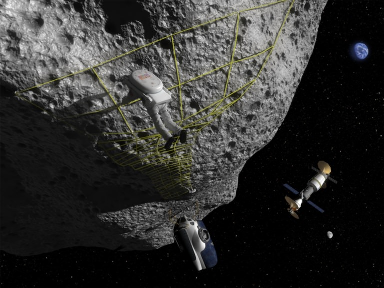
Landing on asteroids will be a risky endeavor, perhaps aggravated by changes in asteroid dust when it's touched. Credit: NASA Near Earth Object Program
NASA is really getting into this crowd-sourcing thing. The space agency asked and the public responded with hundreds of ideas of what missions could be done with asteroids in regards to protecting Earth from these space rocks and finding an asteroid humans can explore. NASA received over 400 responses to their “Asteroid Initiative Request For Information” request, hearing from the space industry, universities, and the general public.
Now, after looking at all the responses, NASA has chosen 96 ideas it regards as most promising, ranging from asteroid observation plans to asteroid redirection, deflection or capture systems, to creating crowd sourcing and citizen science opportunities.
Next, NASA will host an Asteroid Initiative Idea Synthesis Workshop where NASA personnel and the space community will discuss and further these 96 ideas to narrow them down even further to help with its planning activities and future missions.
The 96 ideas were chosen by a team of NASA scientists, engineers, and mission planners who evaluated the proposed ideas. The evaluation team rated the responses for relevance to the RFI objectives, innovativeness of the idea, maturity of the development approach, and potential to improve mission affordability.
This is the first time NASA has used this type of crowd-sourcing and discussion method to look at possible future missions.
NASA said the ideas proposed “provide the agency with fresh insight into how best to identify, capture and relocate a near-Earth asteroid for closer study and respond to asteroid threats.” Ideas included pointers on how to decrease an asteroid’s spin, nudge it away from a path toward Earth, take samples to return to Earth and create activities to heighten public awareness of not only the threat asteroids pose, but the valuable resources and scientific benefits they may offer.
“This rich set of innovative ideas gathered from all over the world provides us with a great deal of information to factor into our plans moving forward,” said Robert Lightfoot, Associate Administrator for NASA. “We’re making great progress on formulating this mission, and we look forward to discussing further the responses we received to the RFI.”
The upcoming public workshop will be held on Sept. 30 – Oct. 2 and onsite participation is limited to just the presenters, but it appears the workshop will be webcast (more info later), as NASA said they will release information on virtual participation options as the workshop nears.
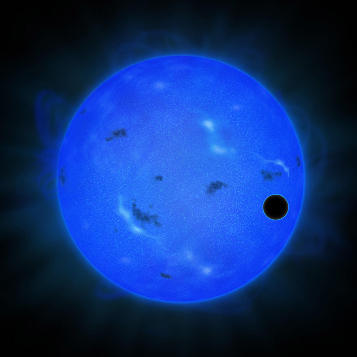
Artist's conception of GJ 1214 b passing across its host star, as viewed in blue light. Credit: NAOJ
Playing with the filters on a telescope can show us amazing things. In a recent case, Japanese astronomers looked at the star Gilese 1214 in blue light and watched its “super-Earth” planet (Gliese 1214 b, or GJ 1214 b) passing across the surface from the viewpoint of Earth. The result — a probable detection of water in the planet’s atmosphere.
Observations with the Subaru Telescope using a blue filter revealed the atmosphere does not preferentially scatter any light. If the Rayleigh scattering had been observed, this would have shown hydrogen in the atmosphere, researchers said. (On Earth, Rayleigh scattering of the atmosphere makes the sky blue.)
“When combined with the findings of previous observations in other colors, this new observational result implies that GJ 1214 b is likely to have a water-rich atmosphere,” stated the National Astronomical Observatory of Japan.
The planet is an ideal candidate for exoplanet observations because it is relatively close to Earth (40 light years away) and is about 2.7 times the size of our planet, allowing for possible comparisons between the worlds.
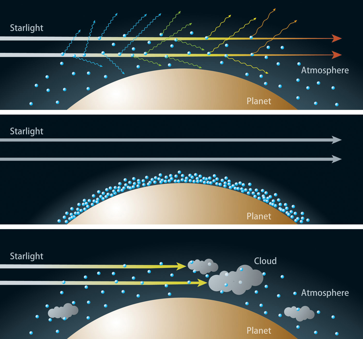
Three images showing the relationship between the atmosphere’s composition and the transmitted colors of light. Top: Hydrogen-dominated atmospheres see much of the blue light scattered, meaning that transits become more visible in blue light than red light. Middle: Atmospheres with less hydrogen scatter blue wavelengths more weakly. Bottom: Cloud-covered planets make it more difficult for light to make its way up through the atmosphere, even if the atmosphere is dominated by hydrogen. Credit: NAOJ
There’s still some debate over whether “super-Earths” are closer in nature to Earth or to Uranus or Neptune (each about four times Earth’s diameter), requiring scientists to scrutinize that class of exoplanets to learn more about their properties.
One area under investigation is where the super-Earths form. It is believed that planets arise out of a protoplanetary disk, or cloud of gas, ice and debris that surrounds a young star at the beginning of its life. Hydrogen is a big part of this disk, as well as water ice beyond the “snow line“, or the region in a planetary system where waning heat makes it possible for ice to form.
“Findings about where super-Earths have formed and how they have migrated to their current orbits point to the prediction that hydrogen or water vapor is a major atmospheric component of a super-Earth,” NAOJ stated. “If scientists can determine the major atmospheric component of a super-Earth, they can then infer the planet’s birthplace and formation history.”
The team acknowledges it’s still possible there is hydrogen in GJ 1214 b’s atmosphere, but add their findings do corroborate with past ones suggesting water.
While taking a look at more than a hundred planetary nebulae in our galaxy’s central bulge, astronomers using the NASA/ESA Hubble Space Telescope and ESO’s New Technology Telescope have found something rather incredible. It would appear that butterfly-shaped planetary nebulae – despite their differences – are somehow mysteriously aligned!
We know that stars similar to our Sun end their lives shedding their outer layers into space. Like a reptile’s intact skin casing, this stellar material forms a huge variety of shapes known as planetary nebulae. One of the more common forms is bipolar – which creates a bowtie or butterfly shape around the progenitor star.
Like snowflakes, no two planetary nebulae are exactly alike. They are created in different places, under different circumstances and have very different characteristics. There is no way that any of these nebulae, nor the responsible stars that formed them, could have interacted with other planetary nebulae. However, according to a new study done by astronomers from the University of Manchester, UK, there seems to be a rather incredible coincidence… A surprising number of these stellar shells are lining up the same way from our galactic point of view.
“This really is a surprising find and, if it holds true, a very important one,” explains Bryan Rees of the University of Manchester, one of the paper’s two authors. “Many of these ghostly butterflies appear to have their long axes aligned along the plane of our galaxy. By using images from both Hubble and the NTT we could get a really good view of these objects, so we could study them in great detail.”
According to the news release, the astronomers observed 130 planetary nebulae in the Milky Way’s central bulge. They identified three different types, and closely examined their characteristics and appearance.
“While two of these populations were completely randomly aligned in the sky, as expected, we found that the third — the bipolar nebulae — showed a surprising preference for a particular alignment,” says the paper’s second author Albert Zijlstra, also of the University of Manchester. “While any alignment at all is a surprise, to have it in the crowded central region of the galaxy is even more unexpected.”
What causes a planetary nebula to take on a particular shape? For some time, astronomers figured their appearance may have been affected by the rotation of the star system in which they form. Many factors could contribute, such as whether or not the spawning star is a binary, or if it has a planetary system. Both of these factors could help mold the eventual outcome of the shed stellar material. However, bipolar planetary nebulae are the most extreme. Astronomers theorize their shapes are the product of jets blowing mass from the binary system perpendicular to the orbit.
“The alignment we’re seeing for these bipolar nebulae indicates something bizarre about star systems within the central bulge,” explains Rees. “For them to line up in the way we see, the star systems that formed these nebulae would have to be rotating perpendicular to the interstellar clouds from which they formed, which is very strange.”
We accept the fact that the properties of the parent stars are the biggest contributor to a planetary nebula’s shape, but this new information gives an enigmatic edge to the final outcome. Not only is each unique, but the Milky Way itself adds even more complexity. The entire central bulge rotates around the galactic center, and this bulge may have considerably more influence than we expected… the influence of its magnetic fields. The researchers suggest this “orderly behavior of the planetary nebulae” may have occurred because a strong magnetic field was present when the bulge formed. Since planetary nebulae nearer to us don’t line up in the same orderly fashion, it would be logical to assume these magnetic fields were much stronger when our galaxy first formed.
“We can learn a lot from studying these objects,” concludes Zijlstra. “If they really behave in this unexpected way, it has consequences for not just the past of individual stars, but for the past of our whole galaxy.”
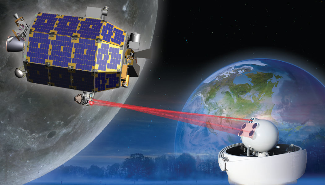
The LADEE satellite in lunar orbit. The revolutionary modular science probe is equipped with a Lunar Laser Communication Demonstration (LLCD) that will attempt to show two-way laser communication beyond Earth is possible, expanding the possibility of transmitting huge amounts of data. This new ability could one day allow for 3-D High Definition video transmissions in deep space to become routine. Credit: NASA
In an exclusive new interview with Universe Today, NASA’s Ames Research Center Director Pete Worden was “very excited” to discuss the historic Moon Shot set to launch NASA’s LADEE lunar orbiter from the Virginia coast and the NASA Wallops Island facility on Friday night, Sept. 6, that boasts “a new modular design” that can revolutionize how we explore our solar system “with robotic orbiters, landers and rovers” – and is aimed at “answering fundamental science questions.”
“LADEE is the first in a new class of interplanetary exploration missions,” NASA Ames Director Worden told Universe Today. NASA Ames leads the LADEE mission. “It will study the pristine moon to study significant questions.”
“And it will demonstrate a new modular approach that will give us science at a lower cost. We are very excited.”
“It will tell us a lot about the moon,” Worden told me.
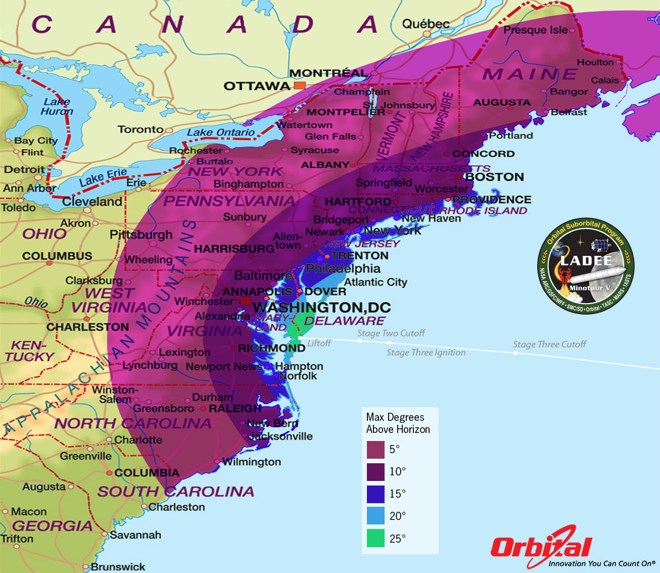
When America returns to the Moon with the LADEE spacecraft blasting off shortly before midnight Sept. 6, it could potentially be watched by many tens of millions of spectators – weather permitting – along the US East Coast stretching from Maine to the Carolina’s and into parts of the Midwest. See launch visibility map below.
LADEE Minotaur V Launch – Maximum Elevation Map
The LADEE nighttime launch will be visible to millions of spectators across a wide area of the Eastern US -weather permitting. This map shows the maximum elevation (degrees above the horizon) that the Minotaur V rocket will reach during the Sep. 6, 2013 launch depending on your location along the US east coast. Credit: Orbital Sciences
And the science timing for LADEE’s lunar mission is just perfect as well since several countries and corporations are gearing up to dispatch a batch of new orbiters and landers to Earth’s nearest neighbor that could change its character forever.
“This is probably our last best chance to study the pristine Moon before there is a lot of human activity there changing things.”
The purpose of LADEE’s trio of science instruments is to collect data that will inform scientists in unprecedented detail about the ultra thin lunar atmosphere, environmental influences on lunar dust and conditions near the surface.
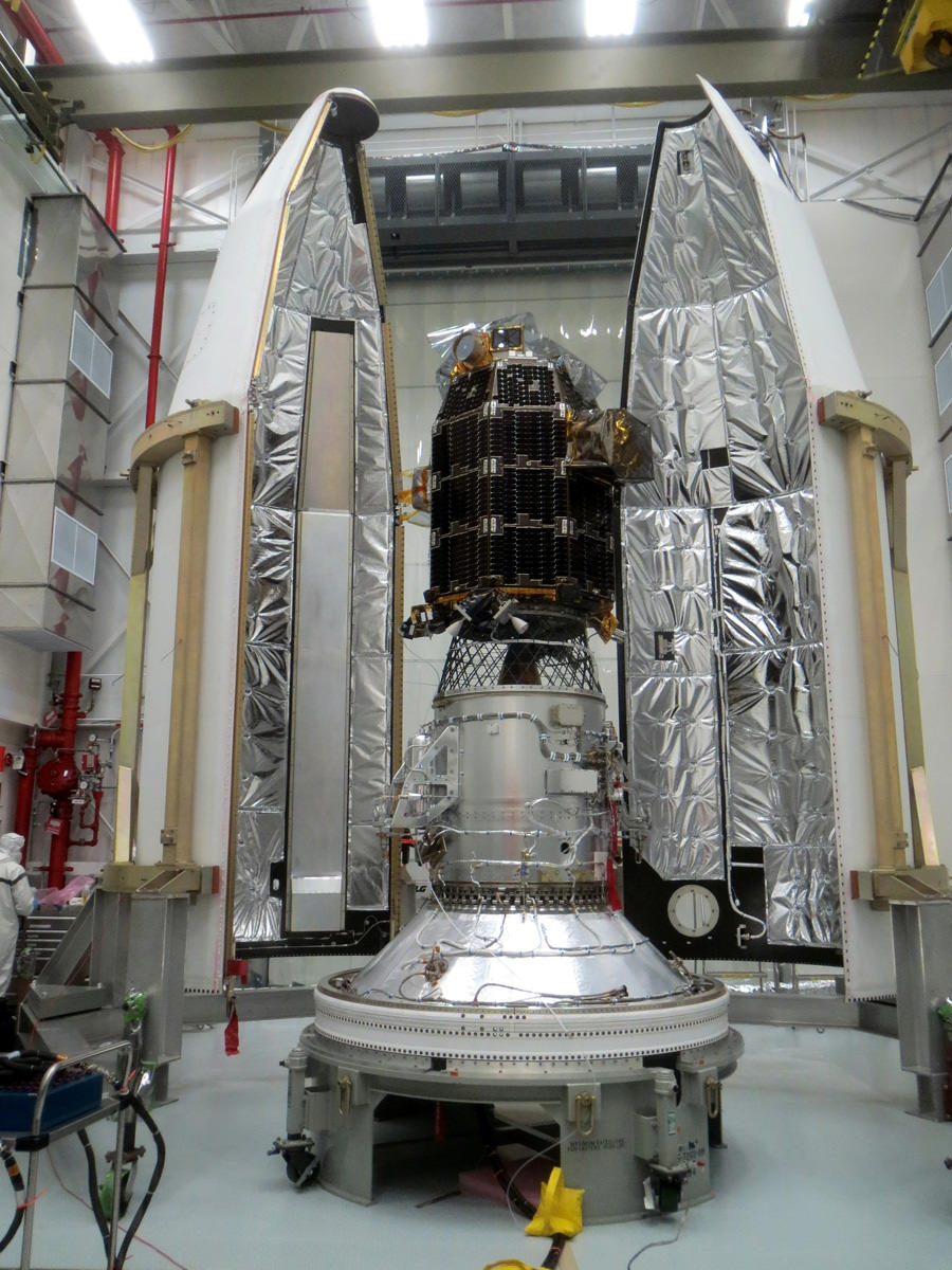
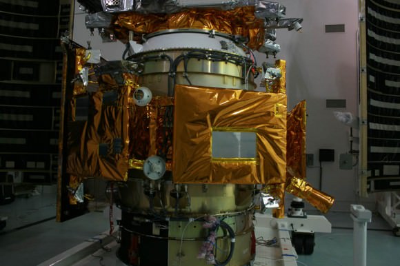
Engineers from NASA’s Ames Research Center have successfully completed launch preparation activities for blastoff of NASA’s Lunar Atmosphere and Dust Environment Explorer (LADEE) observatory on Sept. 6. The revolutionary modular science probe has been encapsulated into the nose-cone of the maiden Minotaur V rocket at NASA’s Wallops Flight Facility. Credit: NASA Ames
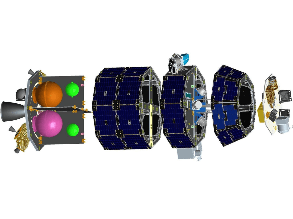
The couch sized probe is built on a ‘modular common spacecraft bus’, or body, that could be implemented on space probes to explore a wide variety of targets in the solar system.
“We think the modular bus is a winner,” Worden explained to Universe Today.
“LADEE could lead to other low cost missions to orbit and even land on the Moon, near Earth asteroids, Mercury and also the moons of Mars.”
“The LADEE bus is a strong contender for future NASA planetary missions, especially landers on bodies with a tenuous atmosphere. And small micro-rovers are possible too. We are really proud of it!”
A computer-generated model of the LADEE spacecraft based on the modular common spacecraft bus. Credit: NASA/Ames
LADEE is NASA’s first ever planetary mission to launch from the Eastern Shore of Virginia at NASA’s Wallops Flight Facility on Wallops Island. The blastoff is expected to draw large crowds. Some local hotels are already sold out.
The Lunar Atmosphere and Dust Environment Explorer (LADEE) Observatory is NASA’s next mission to the Moon.
It thunder’s to space at 11:27 p.m. Friday, Sept. 6, from launch complex 0B at NASA’s Wallops Island facility and the Mid-Atlantic Regional Spaceport (MARS) atop the maiden flight of the new, solid fueled Minotaur V rocket developed by Orbital Sciences Corp.
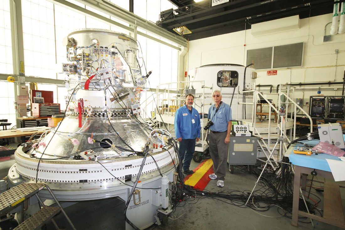
LADEE’s Ticket to the Moon – 5th Stage of new Minotaur V rocket
Close-up view of STAR 37 5th stage solid fuel motor for inaugural Minotaur V rocket launch at NASA Wallops rocket facility will propel LADEE into its lunar transfer orbit. LADEE will be mounted on top and surrounded by the payload fairing attached at bottom ring. Credit: Ken Kremer/kenkremer.com
The goal of the $280 Million mission is to gain a thorough understanding of long-standing unknowns about the tenuous atmosphere, dust and surface interactions that will help scientists understand other planetary bodies as well.
“After Apollo, the amazing thing is that we opened as many questions as we answered,” said Worden. “One of the key issues is – What is the environment on the Moon’s surface from the lunar day to the lunar night?”
“And what are the limitations that would place on our activities there?”
“Although the moon has a tenuous atmosphere it’s actually very active and interacts very strongly with the solar wind. It may produce something that on Earth we would call a ‘dust storm’.”
“We also wish to have the ‘ground truth’ [measurements] of the Moon’s environment before humans change things.”
And change is inexorably coming to the Moon rather soon.
“The Chinese plan to land on the Moon by year’s end,” Worden elaborated.
“What we found during Apollo is that an artificial disturbance very considerably changes the Moon’s atmosphere – or exosphere.”
“So we really want to known the pristine state of the lunar exosphere before its changed by human activity.”
“The data we have from Apollo surface measurements shows that it took many months for the lunar exosphere to go back to its pristine state.”
“Now there are probably a half dozen to a dozen programs planning to land on the Moon in the next decade. So we may never see the Moon’s pristine state again!”
“So these are pretty significant questions that we will have an opportunity to answer with LADEE.”
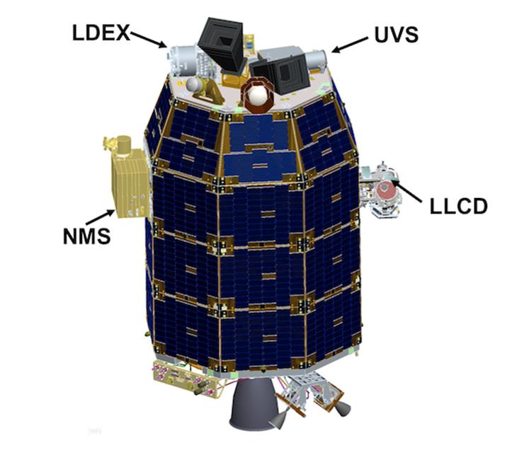
LADEE Science Instrument locations
LADEE is the first spacecraft of any kind that’s been designed, developed, built, integrated and tested at NASA’s Ames Research Center in Moffett Field, Calif.
“This is our first complete mission built out at Ames,” Worden explained.
“It’s also the first of a new paradigm where we are trying to develop a low cost modular bus design.
The approach on LADEE was to make it a mix and match modular bus – rather than a singular modular bus.
“So we have modular slices that use a propulsion stage, lander stage, communications stage, science payload stage, bus housekeeping stage and more,” Worden told me.
“In the past many others tried to build a ‘one size fits all’ modular bus. But it turns out that one size does NOT fit all needs.”
“So we took a page from how you build desktop computers.”
“We put in different modules that you can expand or subtract much more easily without changing the whole fundamental architecture or design.”
“So assuming this works well, I think you will see a lot more missions. And that makes it really exciting as our first mission.”
And the Ames modular bus has definitely sparked entrepreneurial interest.
“The bus is already an approach being used by at least one of the Google Lunar X-Prize competitors! The Moon Express team has looked at it a lot to transition that capability to them,” Worden explained.
How about future NASA missions?
“The LADEE bus is also a key part of several of our Ames proposals for future planetary missions,” Worden replied.
“The original design concept about seven years ago was for a small lunar lander. The lander propulsion would likely be a solid fueled stage.”
“Ultimately, NASA decided to go with the orbiter instead. And that showed the strength of the modular bus design – that it was very easy to change it from a lunar lander to the LADEE mission orbiter studying the lunar exosphere.”
I asked if it could deploy a small rover too?
“Yes- a small, micro rover is possible, perhaps 10 to 20 inches in size. And you could pack a lot of science on the small rover using today’s technology!
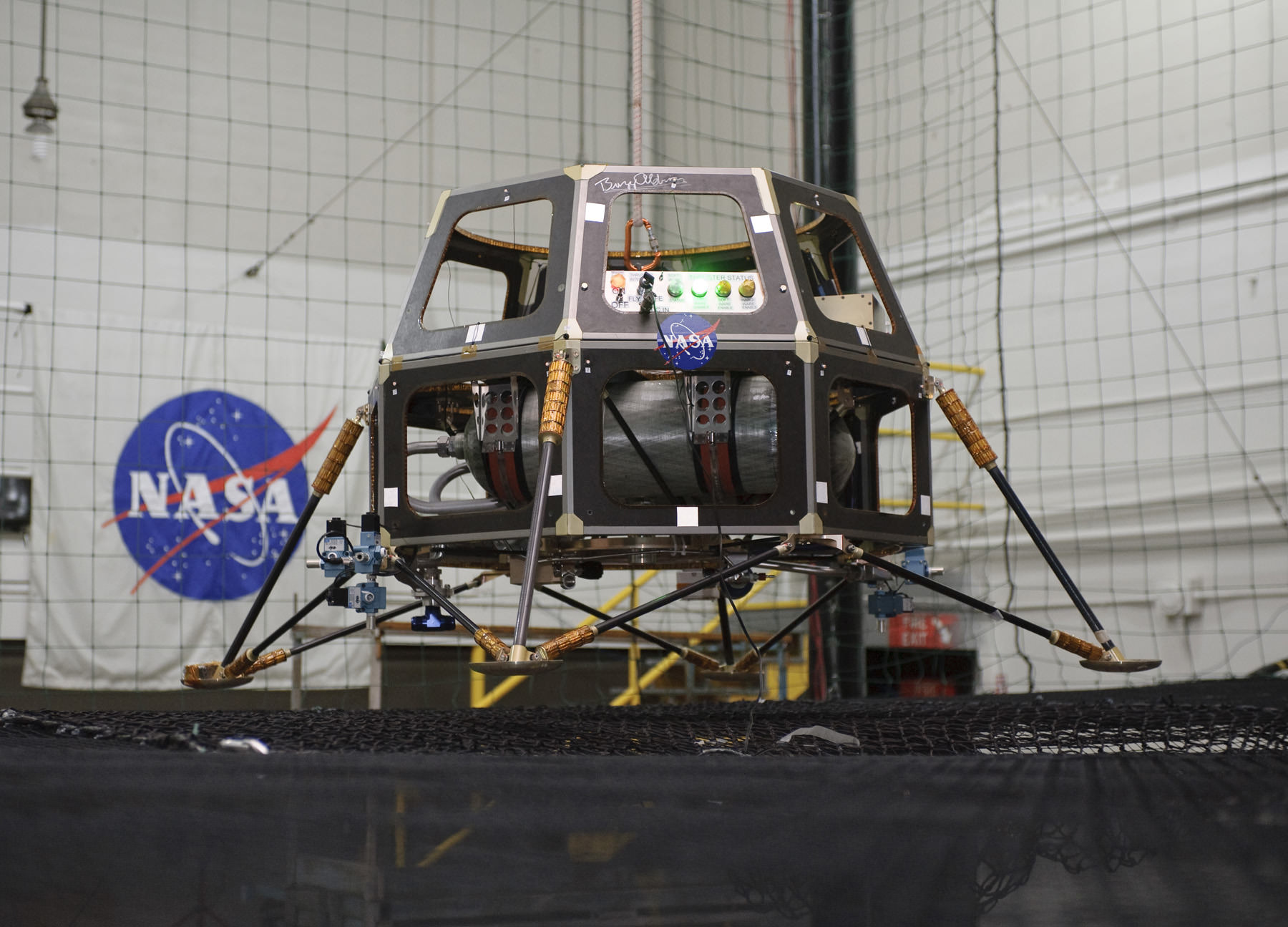
The Modular Common Spacecraft Bus lander configuration in a hover test in 2008. The lander could be used to deploy micro-rovers. Credit: NASA
Thus there are numerous exploration possibilities – all dependent on the Federal budget for NASA in this extremely difficult fiscal environment.
NASA Ames had “built parts and spacecraft components and science instruments before, but not a spacecraft in the entirety and in house,” Worden told Universe Today.
For example, a few years back Ames built the LCROSS lunar impacting spacecraft that smashed into the Moon’s south pole and discovered a treasure trove of water ice.
LCROSS piggybacked as a secondary science mission payload onto NASA’ s Lunar Reconnaisannce Orbiter (LRO) when the duo launched from Cape Canaveral, Florida atop an Atlas V rocket.
NASA Ames has now taken the next step – having designed and built the whole LADEE spacecraft from beginning to end.
“This is our first real baby. It’s very exciting,” beamed Worden.
“LADEE is a pretty phenomenal mission.”
They say “Virginia is for Lovers’
Well coming this Friday, “Virginia is for Space Lovers too!”
Chris Angulo, LADEE Program Engineering manager of Orbital Sciences, and Ken Kremer of Universe Today inspect the 4th and 5th stages of maiden Minotaur V rocket propelling NASA’s LADEE spacecraft to the Moon on Sept. 6 from NASA Wallops in Virginia. Credit: Ken Kremer/kenkremer.com
And remember that NASA has a 2nd historic launch from Wallops slated for Sep. 17 – with blastoff of the Orbital Sciences Antares rocket and Cygnus cargo carrier bound for its 1st flight to the International Space Station (ISS).
Be sure to watch for my continuing LADEE and Antares mission reports from on site at NASA’s Wallops Launch Pads in sunny Virginia – reporting for Universe Today.
…………….
Learn more about LADEE, Cygnus, Antares, MAVEN, Orion, Mars rovers and more at Ken’s upcoming presentations
Sep 5/6/16/17: “LADEE Lunar & Antares/Cygnus ISS Rocket Launches from Virginia”; Rodeway Inn, Chincoteague, VA, 8 PM
Oct 3: “Curiosity, MAVEN and the Search for Life on Mars – (3-D)”, STAR Astronomy Club, Brookdale Community College & Monmouth Museum, Lincroft, NJ, 8 PM
Oct 9: “LADEE Lunar & Antares/Cygnus ISS Rocket Launches from Virginia”; Princeton University, Amateur Astronomers Assoc of Princeton (AAAP), Princeton, NJ, 8 PM
Close Up Side view of NASA Ames built LCROSS lunar impactor. NASA Ames LADEE orbiter is equipped with the UVS science instrument based on LCROSS heritage. Credit: Ken Kremer/kenkremer.com
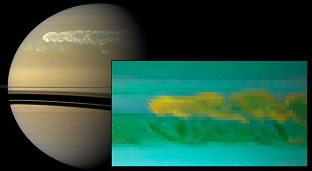
This set of images from NASA's Cassini mission shows the turbulent power of a monster Saturn storm. The visible-light image in the back, obtained on Feb. 25, 2011, by Cassini's imaging camera, shows the turbulent clouds churning across the face of Saturn. The inset infrared image, obtained a day earlier, by Cassini's visual and infrared mapping spectrometer, shows the dredging up of water and ammonia ices from deep in Saturn's atmosphere. This was the first time water ice was detected in Saturn's atmosphere. Credit: NASA/JPL-Caltech/SSI/Univ. of Arizona/Univ. of Wisconsin
Remember the huge storm that erupted on Saturn in late 2010? It was one of the largest storms ever observed on the ringed planet, and it was even visible from Earth in amateur-sized telescopes. The latest research has revealed the tempestuous storm churned up something surprising deep within Saturn’s atmosphere: water ice. This is the first detection of water ice on Saturn, observed by the near-infrared instruments on the Cassini spacecraft.
“The new finding from Cassini shows that Saturn can dredge up material from more than 100 miles [160 kilometers],” said Kevin Baines, a co-author of the paper who works at the University of Wisconsin-Madison and NASA’s Jet Propulsion Laboratory, Pasadena, Calif. “It demonstrates in a very real sense that typically demure-looking Saturn can be just as explosive or even more so than typically stormy Jupiter.”
While Saturn’s moons have lots of water ice, Saturn is almost entirely hydrogen and helium, but it does have trace amounts of other chemicals, including water. When we look at Saturn, we’re actually seeing the upper cloud tops of Saturn’s atmosphere, which are made mostly of frozen crystals of ammonia.
Beneath this upper cloud layer, astronomers think there’s a lower cloud deck made of ammonium hydrosulfide and water. Astronomers thought there was water there, but not very much, and certainly not ice.
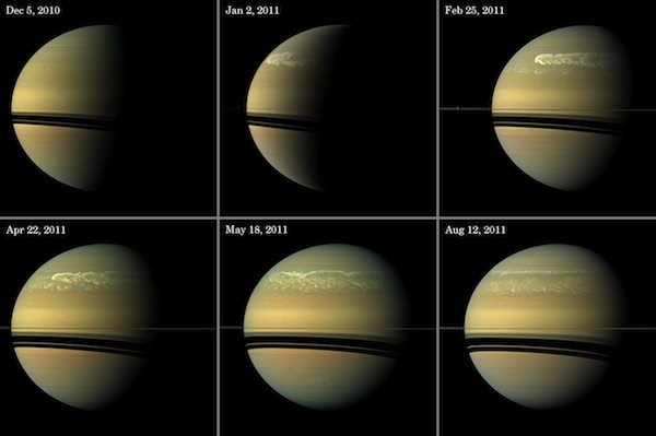
This series of images from NASA’s Cassini spacecraft shows the development of the largest storm seen on the planet since 1990. These true-color and composite near-true-color views chronicle the storm from its start in late 2010 through mid-2011, showing how the distinct head of the storm quickly grew large but eventually became engulfed by the storm’s tail. Credit: NASA/JPL-Caltech/Space Science Institute
But the storm in 2010-2011 appears to have disrupted the various layers, lofting up water vapor from a lower layer that condensed and froze as it rose. The water ice crystals then appeared to become coated with more volatile materials like ammonium hydrosulfide and ammonia as the temperature decreased with their ascent, the authors said.
“The water could only have risen from below, driven upward by powerful convection originating deep in the atmosphere,” said Lawrence Sromovsky, also of the University of Wisconsin, who lead the research team. “The water vapor condenses and freezes as it rises. It then likely becomes coated with more volatile materials like ammonium hydrosulfide and ammonia as the temperature decreases with their ascent.
Big storms appear in the northern hemisphere of Saturn once every 30 years or so, or roughly once per Saturn year. The first hint of the most recent storm first appeared in data from Cassini’s radio and plasma wave subsystem on Dec. 5, 2010. Soon after that, it could be seen in images from amateur astronomers and from Cassini’s imaging science subsystem. The storm quickly grew to superstorm proportions, encircling the planet at about 30 degrees north latitude for an expanse of nearly 300,000 km (190,000 miles).
The researchers studied the dynamics of this storm, and realized that it worked like the much smaller convective storms on Earth, where air and water vapor are pushed high into the atmosphere, resulting in the towering, billowing clouds of a thunderstorm. The towering clouds in Saturn storms of this type, however, were 10 to 20 times taller and covered a much bigger area. They are also far more violent than an Earth storm, with models predicting vertical winds of more than about 300 mph (500 kilometers per hour) for these rare giant storms.
The storm’s ability to churn up water ice from great depths is evidence of the storm’s explosive power, the team said.
Their research will be published in the Sept. 9 edition of the journal Icarus.
Illustration of the Kepler spacecraft. Kepler's mission is over, but all of the exoplanets it found still need to be confirmed in follow-up observations. (NASA/Kepler mission/Wendy Stenzel)
Kepler may not be hanging up its planet-hunting hat just yet. Even though two of its four reaction wheels — which are crucial to long-duration observations of distant stars — are no longer operating, it could still be able to seek out potentially-habitable exoplanets around smaller stars. In fact, in its new 2-wheel mode, Kepler might actually open up a whole new territory of exoplanet exploration looking for Earth-sized worlds orbiting white dwarfs.
An international team of scientists, led by Mukremin Kilic of the University of Oklahoma’s Department of Physics and Astronomy, are suggesting that NASA’s Kepler spacecraft should turn its gaze toward dim white dwarfs, rather than the brighter main-sequence stars it was previously observing.
“A large fraction of white dwarfs (WDs) may host planets in their habitable zones. These planets may provide our best chance to detect bio-markers on a transiting ex- oplanet, thanks to the diminished contrast ratio between the Earth-sized WD and its Earth-sized planets. The James Webb Space Telescope is capable of obtaining the first spectroscopic measurements of such planets, yet there are no known planets around WDs. Here we propose to take advantage of the unique capability of the Kepler space- craft in the 2-Wheels mode to perform a transit survey that is capable of identifying the first planets in the habitable zone of a WD.”
– Kilic et al.
Any bio-markers — such as molecular oxygen, O2 — could later be identified around such Earth-sized exoplanets by the JWST, they propose.
Will Kepler be able to find the first Earth-sized exoplanet — or even an exomoon — orbiting a white dwarf? (Illustration of Kepler 22b. Credit: NASA/Ames/JPL-Caltech)
Because Kepler’s precision has been greatly reduced by the failure of a second reaction wheel earlier this year, it cannot accurately aim at large stars for the long periods of time required to identify the minute dips in brightness caused by the silhouetted specks of passing planets. But since white dwarfs — the dim remains of stars like our Sun — are much smaller, any eclipsing exoplanets would make a much more pronounced effect on their apparent luminosity.
In effect, exoplanets ranging from Earth- to Jupiter-size orbiting white dwarfs as close as .03 AU — well within their habitable zones — would significantly block their light, making Kepler’s diminished aim not so much of an issue.
“Given the eclipse signature of Earth-size and larger planets around WDs, the systematic errors due to the pointing problems is not the limiting factor for WDHZ observations,” the team assures in their paper “Habitable Planets Around White Dwarfs: an Alternate Mission for the Kepler Spacecraft.”
Even smaller orbiting objects could potentially be spotted in this fashion, they add… perhaps even as small as the Moon.
The team is proposing a 200-day-long survey of 10,000 known white dwarfs within the Sloan Digital Sky Survey (SDSS) area, and expects to find up to 100 exoplanet candidates as well as other “eclipsing short period stellar and sub-stellar companions.”
“If the history of exoplanet science has taught us anything, it is that planets are ubiquitous and they exist in the most unusual places, including very close to their host stars and even around pulsars… Currently there are no known planets around WDs, but we have never looked at a sufficient number of WDs at high cadence to find them through transit observations.”
NASA’s Ames Research Center made an open call for proposals regarding Kepler’s future operations on August 2. Today is the due date for submissions, which will undergo a review process until Nov. 1, 2013.
Added 9/4: For another take on this, check out Paul Gilster’s write-up on Centauri Dreams.
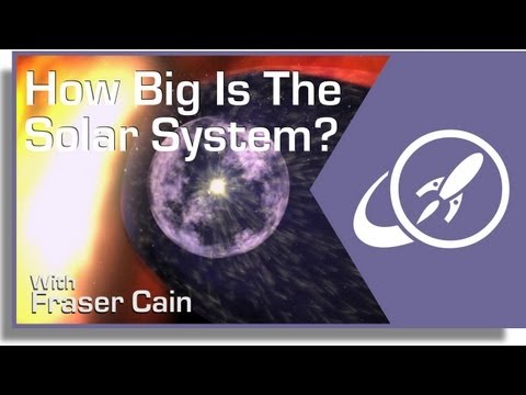
For most of us, stuck here on Earth, we see very little of the rest of the Solar System. Just the bright Sun during the day, the Moon and the planets at night. But in fact, we’re embedded in a huge Solar System that extends across a vast amount of space.
Which begs the question, just how big is the Solar System?
Before we can give a sense of scale, let’s consider the units of measurement.
Distances in space are so vast, regular meters and kilometers don’t cut it. Astronomers use a much larger measurement, called the astronomical unit. This is the average distance from the Earth to the Sun, or approximately 150 million kilometers.
Mercury is only 0.39 astronomical units from the Sun, while Jupiter orbits at a distance of 5.5 astronomical units. And Pluto is way out there at 39.2 astronomical units.
That’s the equivalent of 5.9 billion kilometers.
If you could drive your car at highway speeds, from the Sun all the way out to Pluto, it would take you more than 6,000 years to complete the trip.
But here’s the really amazing part. Our Solar System extends much, much farther than where the planets are.
The furthest dwarf planet, Eris, orbits within just a fraction of the larger Solar System.
The Kuiper Belt, where we find a Pluto, Eris, Makemake and Haumea, extends from 30 astronomical units all the way out to 50 AU, or 7.5 billion kilometers.
And we’re just getting started.
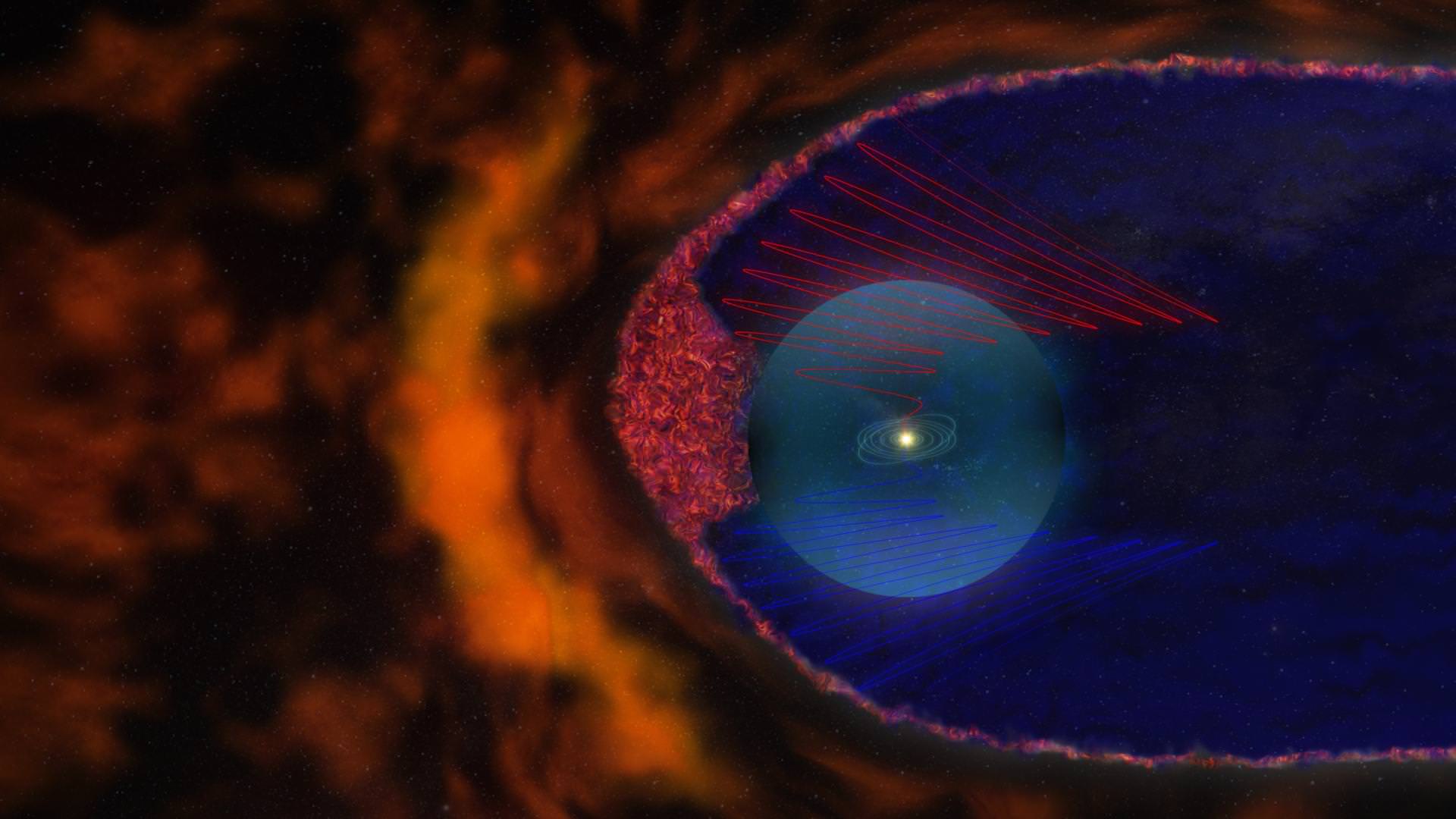
Artist’s interpretation depicting the new view of the heliosphere. The heliosheath is filled with “magnetic bubbles” (shown in the red pattern) that fill out the region ahead of the heliopause. In this new view, the heliopause is not a continuous shield that separates the solar domain from the interstellar medium, but a porous membrane with fingers and indentations. Credit: NASA/Goddard Space Flight Center/CI LabEven further out, at about 80-200 AU is the termination shock. This is the point where the Sun’s solar wind, traveling outward at 400 kilometers per second collides with the interstellar medium – the background material of the galaxy. This material piles up into a comet-like tail that can extend 230 AU from the Sun.
But the true size of the Solar System is defined by the reach of its gravity; how far away an object can still be said to orbit the Sun.
The layout of the solar system, including the Oort Cloud, on a logarithmic scale. Credit: NASAIn the furthest reaches of the Solar System is the Oort Cloud; a theorized cloud of icy objects that could orbit the Sun to a distance of 100,000 astronomical units, or 1.87 light-years away. Although we can’t see the Oort Cloud directly, the long-period comets that drop into the inner Solar System from time to time are thought to originate from this region.
The Sun’s gravity dominates local space out to a distance of about 2 light-years, or almost half the distance from the Sun to the nearest star: Proxima Centauri. Believe it or not, any object within this region would probably be orbiting the Sun, and be thought to be a part of the Solar System.
Back to our car analogy for a second. At those distances, it would take you 19 million years to complete the journey to the edge of the Solar System. Even NASA’s New Horizons spacecraft, the fastest object ever launched from Earth would need 37,000 years to make the trip.
So as you can see, our Solar System is a really really big place.
An ultracold vacuum chamber ran a simulation of the early universe and came up with some interesting findings about how the environment looked shortly after the Big Bang occurred.
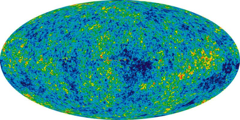
Specifically, the atoms clustered in patterns similar to the cosmic microwave background — believed to be the echo of the intense burst that formed the beginning of the universe. Scientists have mapped the CMB at progressively higher resolution using several telescopes, but this experiment is the first of its kind to show how structure evolved at the beginning of time as we understand it.
The Big Bang theory (not to be confused with the popular television show) is intended to describe the universe’s evolution. While many pundits say it shows how the universe came “from nothing”, the concordance cosmological model that describes the theory says nothing about where the universe came from. Instead, it focuses on applying two big physics models (general relativity and the standard model of particle physics). Read more about the Big Bang here.
CMB is, more simply stated, electromagnetic radiation that fills the Universe. Scientists believe it shows an echo of a time when the Universe was much smaller, hotter and denser, and filled to the brim with hydrogen plasma. The plasma and radiation surrounding it gradually cooled as the Universe grew bigger. (More information on the CMB is here.) At one time, the glow from the plasma was so dense that the Universe was opaque, but transparency increased as stable atoms formed. But the leftovers are still visible in the microwave range.
WMAP data of the Cosmic Microwave Background. Credit: NASA
The new research used ultracold cesium atoms in a vacuum chamber at the University of Chicago. When the team cooled these atoms to a billionth of a degree above absolute zero (which is -459.67 degrees Fahrenheit, or -273.15 degrees Celsius), the structures they saw appeared very similar to the CMB.
By quenching the 10,000 atoms in the experiment to control how strongly the atoms interact with each other, they were able to generate a phenomenon that is, very roughly speaking, similar to how sound waves move in air.
“At this ultracold temperature, atoms get excited collectively,” stated Cheng Chin, a physics researcher at the University of Chicago who participated in the research. This phenomenon was first described by Russian physicist Andrei Sakharov, and is known as Sakharov acoustic oscillations.
So why is the experiment important? It allows us to more closely track what happened after the Big Bang.
Atom density is greater at left (the beginning of the experiment) than 80 milliseconds after the simulated Big Bang. Credit: Chen-Lung Hung
The CMB is simply a frozen moment of time and is not evolving, requiring researchers to delve into the lab to figure out what is happening.
“In our simulation we can actually monitor the entire evolution of the Sakharov oscillations,” said Chen-Lung Hung, who led the research, earned his Ph.D. in 2011 at the University of Chicago, and is now at the California Institute of Technology.
Both Hung and Chin plan to do more work with the ultracold atoms. Future research directions could include things such as how black holes work, or how galaxies were formed.
An aurora seen in Norway on Aurora Borealis from September 2, 2013. Credit and copyright: Frank Olsen.
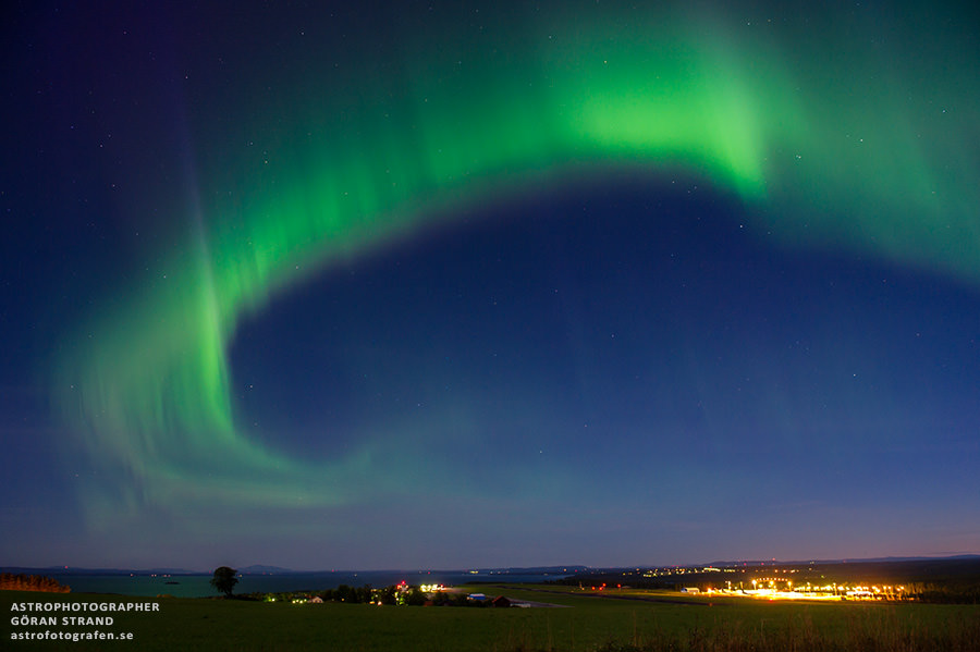
Aurora season must have started in Scandinavia! Frank Olsen just posted this fantastic shot of the Aurora Borealis dancing across the sky and reflecting on the water in Norway, and below, astrophotographer Göran Strand recently captured shots of the aurora from northern Sweden. Enjoy these shimmering beauties and we look forward to seeing more aurora as the summer winds down in the northern hemisphere.
Aurora over northern Sweden on August 23, 2013. Credit and copyright: Göran Strand.
Want to get your astrophoto featured on Universe Today? Join our Flickr group or send us your images by email (this means you’re giving us permission to post them). Please explain what’s in the picture, when you took it, the equipment you used, etc.
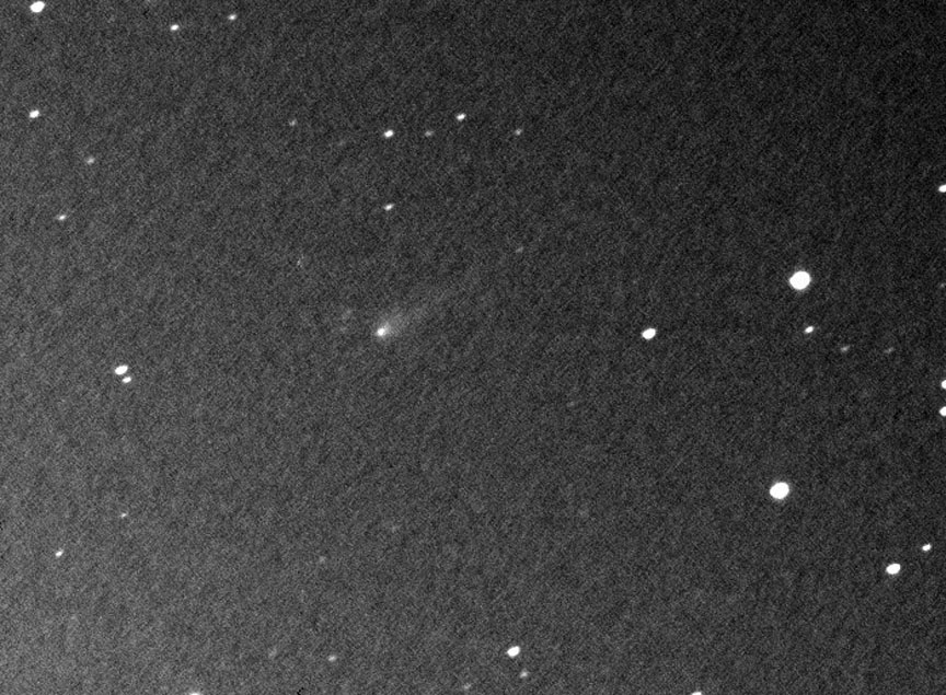
Comet ISON shows a small, compact coma and short, faint tail in this photo made by Krisztian Sarneczky on Aug. 31, 2013. Credit: K. Sárneczky / Konkoly Observatory
OK, you’ve waited patiently for Comet ISON to brighten and reappear in the dawn sky. It has. Now you’re chomping at the bit for a look at it in your telescope. Before you set the alarm and venture into the night, let’s prepare for what to expect. The better you know your target, the easier it will be to find.
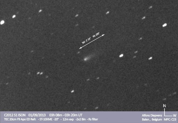
Astrophotographer Alfons Diepvens captured this view of ISON on Sept. 1, 2013 through his telescope. Tail length and direction are indicated. Click image to see more his photos of ISON and other recent comets. Credit: Alfons Diepvens
The latest brightness estimates from the amateur comet community place ISON around magnitude 13, bright enough to be within reach of 10-inch (25 cm) and larger telescopes. Alan Hale of Arizona, co-discover of Comet Hale-Bopp, was one of the first to see it. Through his 16-inch (41 cm) reflecting telescope on September 1, he noted the comet as a small object about 0.6 arc minutes across (1 arc minute = 1/30 the diameter of the full moon), brighter in the center and shining faintly at magnitude 13.1. Picture a small, dim patch of glowing mist and you’ve got the picture. Hale’s observing conditions were excellent though he did have to contend with light from the nearby crescent moon. Starting tomorrow morning, the moon will finally be out of the picture.
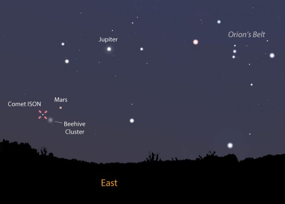
With the moon out of the sky, now is a great time to hunt for Comet ISON. This map shows the sky as you face east tomorrow morning Sept. 3 around 5 a.m. local time just before the start of morning twilight. The comet is near both Mars and the Beehive Cluster. Stellarium
A sharp-eyed observer under the best skies would expect to see a fuzzy object this faint in a telescope as small as 8-inches (20 cm). Most of us will need something a little bigger. A 10-12 incher (25-30 cm) should do the trick until the comet swells into the 11-12 magnitude range. But you’ll need more than a hefty scope. Key to spotting ISON are good charts, a steady atmosphere for sharp images (shaky air blurs faint objects into invisibility) and catching the comet at the right time. I also encourage you to use averted vision, a great technique for spotting faint sky objects. Instead of staring directly at the comet, look off to the side of its position. That way you allow the comet’s feeble photons to flood your eye’s rod cells, those most sensitive to dim light.
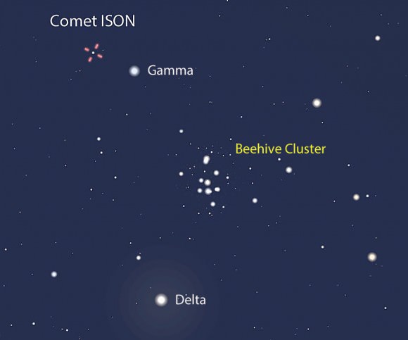
This tighter view shows the comet (on Sept. 3) in relation to the naked eye star Gamma Cancri and the pretty Beehive Cluster in Cancer the Crab. North is up, west to the right. Stellarium
While it now rises around 3-3:30 a.m. local time, you’ll get your best – or only – view once ISON has cleared the light-sucking thick air and haze so common near the horizon. The optimum viewing time occurs shortly before the start of morning twilight when the comet will be about 15 degrees high in the northeastern sky. At mid-northern latitudes,where twilight begins about 1.5 hours before sunrise, that’s around 5 a.m. Did I mention you’d lose a few hours sleep in your pursuit?
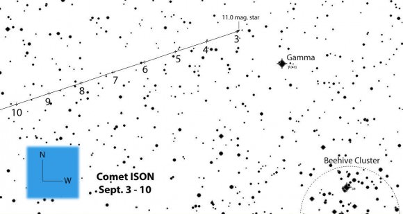
Comet ISON’s position plotted for 5 a.m. Central Daylight Time tomorrow through the 10th. Stars are shown to 12th magnitude. Click for larger version. Created with Chris Marriott’s SkyMap Pro program
Lucky for us comet hunters, ISON’s location is easy to find only a few degrees east of the 1st magnitude planet Mars and about 2 degrees north of the familiar Beehive Cluster or M44. The first map shows the general view to get you oriented. The second takes us in closer to show the comet’s relation to the Beehive Cluster, and the third provides a detailed telescopic view with stars plotted to about 12th magnitude. The comet positions on the detailed map are plotted for 5 a.m. CDT. Since ISON moves relatively slowly, those positions will be accurate for a time zone or two either way. If you live significantly farther east or west of the U.S. Central Time Zone, you can interpolate between the tick marks.
It’s good news for skywatchers from here on out as ISON continues to brighten and rise higher in the east with each passing night. A month from now, it should be visible in scopes as small as 6-inches (15 cm). Good luck in your comet quest!