There is almost nothing that could completely destroy the earth.
Follow your instincts and ignore anyone raising alarms about its imminent demise.
Oh sure, there’s a pile of events that could make life more difficult, and a laundry list of things that could wipe out all of humanity. Including: asteroid strikes, rising temperatures, or global plagues
In order to actually destroy the Earth, you would need significantly more energy, and there just happens to be enough, a short 150 million kilometers away: the Sun.
The Sun has been in the main sequence of its life for the last 4.5 billion years, converting hydrogen into helium. For stars this massive, that phase lasts for about 10 billion years, meaning we’re only halfway through.
When the Sun does finally run out of hydrogen to burn, it’ll begin fusing helium into carbon, expanding outward in the process. It will become a cooler, larger, red giant star, consuming the orbits of Mercury and Venus.
Scientists are still unsure if the red giant phase of the Sun will consume the Earth. If it does, the Earth’s story ends there. It’ll get caught up inside the Sun, and spiral inward to its demise.
Death by red giant in 5.5 billion years.
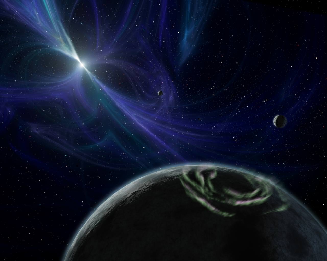
If the Sun doesn’t consume the Earth then we’ll have a long, cold future ahead of us. The Sun will shrink down to a white dwarf and begin cooling down to the background temperature of the Universe. The Earth and the rest of the surviving planets will continue orbiting the dying Sun for potentially trillions of years.
Planet orbiting a dead star. Credit: NASAIf we’re exceedingly lucky, the Sun will get too close to another star, and the gravitational interactions will capture Earth in orbit, giving our planet a second chance for life. If not, the Earth will continue following the dying Sun around and around the Milky Way for an incomprehensible amount of time.
At this point, the main risk to the planet is a collision. Or maybe it’ll spiral inward over vast periods of time to be destroyed by the Sun, or collide with another planet. Or perhaps the entire Solar System will slowly make its way into the supermassive black hole at the center of the Milky Way.
One last possibility. Physicists think that protons – the building blocks of atoms – might eventually decay, becoming smaller particles and pure energy. After an undecillion years – a 1 followed by 36 zeros – half of the Earth will have just melted away into energy.
But if protons don’t decay, the Earth could theoretically last forever.
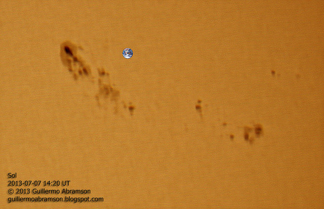
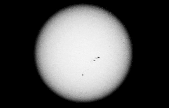
Sunspot regions 1785 and 1787, with Earth shown to scale. Credit: Guillermo Abramson
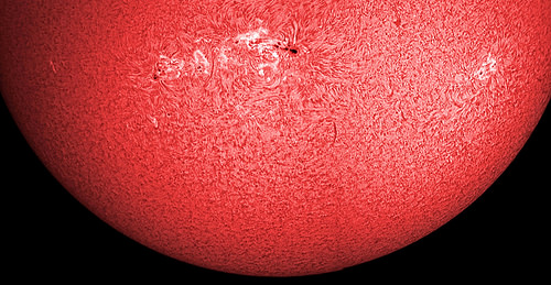
Do you feel like you’re in the firing gallery? These sunspots are practically square-on to Earth right now. Although they haven’t shown much sign of erupting, if they did our planet would be right in the line of fire if a flare or stream of solar particles erupted.
These groups (known as 1785 and 1787) are so big that they are easily visible in amateur telescopes. 1785 alone is more than 11 Earth-diameters across, according to SpaceWeather.com! Just make sure you have the proper solar filters in place before you gaze at these dark smudges.
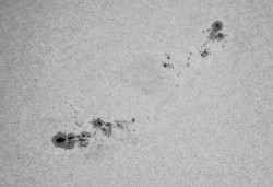
A black-and-white view of the string of sunspots facing Earth right now. Credit: Paul M. Hutchinson
“Sunspots” — so called because they appear as dark smudges on the face of the sun — are areas of intense magnetic activity on the sun (thousands of times stronger than that of Earth’s magnetic field.)
At times, these regions can get so intense that the energy builds up and releases in the form of a flare and/or a coronal mass ejection — a burst of gas and magnetism that hurls solar material away from the sun.
If these flares hit the area of the Earth, a bunch of things can happen. Particles can flow along Earth’s magnetic lines and lead to the creation of aurora, or Northern/Southern lights. (Here’s an aurora that happened in June.) More severe storms can short out satellites or disable power lines.
“Could it be the calm before the storm?” SpaceWeather.com asked on its homepage, before giving forecasts of strong types of flares: “NOAA forecasters estimate a 55% chance of M-flares and a 10% chance of X-flares on July 8.”
We’ll keep our eyes peeled and let you know if something interesting happens. In the meantime, these pictures came from Universe Today readers, and we’d love to see your images, too! Feel free to add your snapshots to our Flickr page.
Update, 2:39 EDT: Among the pictures in our Flickr pool is this new stunner below from Ron Cottrell of Oro Valley, Arizona. “These sunspots are so magnificent that I get striking detail with my small 40mm Hydrogen-alpha telescope,” he wrote us.
A large sunspot group taken in July 2013 with a 40mm Hydrogen-alpha telescope. Credit: Ron Cottrell
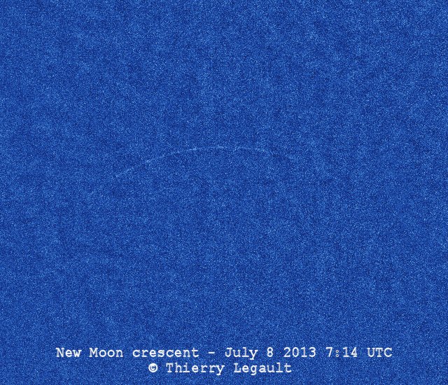
This image shows the tiny lunar crescent at the precise moment of the New Moon, in full daylight at 7h14min UTC on July 8 2013. Credit and copyright: Thierry Legault.
It’s always striking to see a tiny sliver of the New Moon. But you’ve probably never seen a sliver this tiny or a Moon this “new” before. This brand new image by astrophotographer extraordinaire Thierry Legault was taken this morning and is the youngest possible lunar crescent, with the “age” of the Moon at this instant being exactly zero — at the precise moment of the New Moon. The image was taken in full daylight at 07:14 UTC on July 8, 2013.
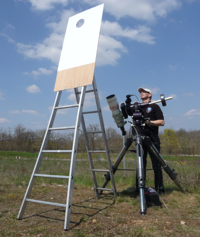
Normally it is just about impossible (and dangerous) to see this, as when the Moon is this “new,” the Moon is between the Earth and the Sun and it is so close to the Sun in our sky that it can’t be seen because of the Sun’s glare. Plus, the New Moon appears as an extremely thin crescent which is barely brighter than the blue sky. But Thierry has designed a special sunshade to prevent sunlight from entering the telescope (see it below).
Thierry says the irregularities and discontinuities seen in the edge of the crescent are caused by the relief at the edge of the lunar disk; i.e. mountains and craters on the Moon. Very cool!
The “New Moon” is defined as the instant when the Moon is at the same ecliptic longitude as the Sun. When we refer to the “age” of the Moon, it is the number of hours (or days) since New Moon.
From Thierry’s shooting site in Elancourt, France (a suburb of Paris), the angular separation between the Moon and the Sun was only 4.4° (nine solar diameters).
“At this very small separation, the crescent is extremely thin (a few arc seconds at maximum) and, above all, it is drowned in the solar glare, the blue sky being about 400 times brighter than the crescent itself in infrared (and probably more than 1000 times in visible light),” Thierry writes on his website. “In order to reduce the glare, the images have been taken in close infrared and a pierced screen, placed just in front of the telescope, prevents the sunlight from entering directly in the telescope.”
Thierry Legault with his special telescope filter for blocking the Sun’s rays. Image courtesy Thierry Legault.
Thierry cautions anyone trying to see this with the naked eye. Basically, don’t try it.
“The very thin crescent of the New Moon cannot be observed visually whatever the instrument (naked eye, binoculars, telescope, etc),” he said. “Moreover, pointing a celestial object that close to the Sun is dangerous for the observer and his equipment if it is not performed under the control of an experienced astronomer and with the proper equipment.”
If you want to keep track of what the Moon will look like each night (or day!), Universe Today has a great app for that, our Phases of the Moon app, available for iOS or Android.
Seeing familiar shapes in clouds is easy especially when you've got a handy reference. Credit: Andrew Kirk
As kids, my friends and I would stare at clouds on lazy summer afternoons and point out faces and animals we saw in their folds and domes. When the light was right, some of them looked as detailed and real as if chiseled by a meteorological Michelangelo. Later, with kids of our own, we often revisit this simple pleasure.
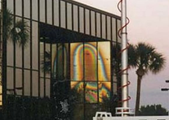
image of the “Virgin Mary” appears in the glass of a Tampa, Florida office building on Christmas Day 1996. Credit: Wikipedia
Patterns can materialize anywhere – old men with scraggly beards in carpeting, blocky visages in road cuts and even Jesus on toast. Here are 50 more fun examples. Our instinctive ability to find patterns in the often random mish-mash of nature is called pareidolia (pair-eye-DOLE-ya).
The late planetary scientist and astronomy popularizer Carl Sagan believed pattern-recognition was part of our evolutionary heritage:
“As soon as the infant can see, it recognizes faces, and we now know that this skill is hardwired in our brains,” wrote Sagan. “Those infants who a million years ago were unable to recognize a face smiled back less, were less likely to win the hearts of their parents, and less likely to prosper.”
Maybe it’s simpler than that. Face-recognition is critical because we ultimately need each other for survival not to mention keeping track of the kids in the grocery store. Pattern recognition also helped us find food back in the days of hunting and gathering. The ability to distinguish a particular plant or animal against the background noise meant the difference between a full belly or starvation.
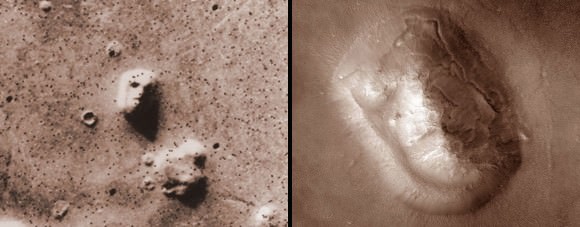
The infamous Mars Face (left) photographed in comparatively low resolution by the Viking orbiter in 1976 and a much higher resolution view made by current Mars Reconnaissance Orbiter. Credit: NASA
Pareidolia also works its magic across the cosmos. To narrow the scope, I’ve selected images taken of Mars, the most fertile planet for imaginary faces around. Who doesn’t remember all the hubbub over the “Face of Mars”? Old Viking spacecraft images from the mid-1970s taken at low resolution in slanted lighting seemed to show a face carved of rock staring back at Earth.
Since pareidolia works best when the stimulus is vague or the object unclear the “face” was perfect. Our brains are more than happy to fill in fictional details. Later photos taken at much lower altitude with higher resolution cameras made the face disappear; in its place we clearly see an eroded mesa. Then there’s the so-called “Bigfoot on Mars,” (an extremely very tiny Bigfoot) and later someone zoomed in on a small rock and said there was a gorilla on Mars. Information equals identity, lack of detail opens the door to anything we might imagine.
Here are 10 examples of imaginary faces and creatures on Mars. The inspiration to write about the topic came from a series of recent “art” images taken with the THEMIS camera on board the Mars Odyssey spacecraft. The probe orbits Mars every 2 hours and carries three science instruments; the camera combines images shot in 5 wavelengths or colors of visual light and 9 in the infrared or heat-emitting part of the spectrum. Others were snapped by the Mars Reconnaissance Orbiter. All are NASA images, and I’ve taken the liberty to colorize several of the black and whites to approximate the appearance of the color images.
Enjoy!
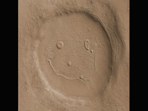
1.My Happy Martian
Martians obviously have a sense of humor. This 2-mile-wide (3 km) unnamed crater was photographed in 2008 by the Mars Reconnaissance Orbiter.
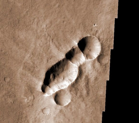
2. That Buzzing Sound
This crater chain with its wispy “wings” of impact debris resembles a wasp. The feature was most likely created when a meteorite arriving it at a very low angle broke into pieces just before impact.
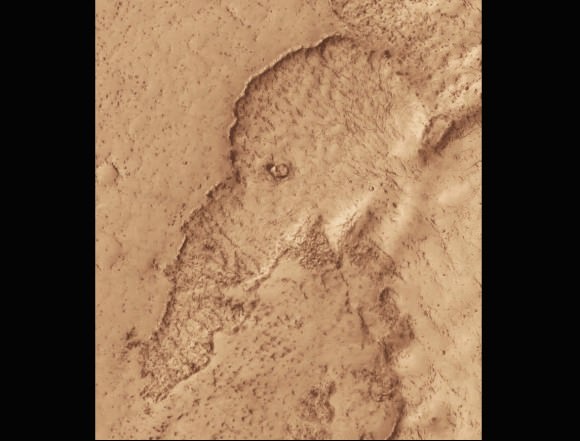
3. The Mammoth Still Lives
Lava flows in Mars’ Elysium Planitia region have left a rather good likeness of a woolly mammoth or elephant. The region is known for some of the planet’s youngest lavas – this one may have formed as recently as the past 100 million years.
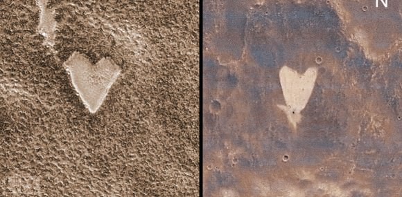
4. Have A Heart (or two)
I love these two little hearts. The one on the left is a mesa top outlined by frost about the size of a football stadium. On the right, a small impact crater near the tip of the heart blew away dark surface material exposing lighter soil beneath. Some of the material appears to have flowed downslope to create the heart.
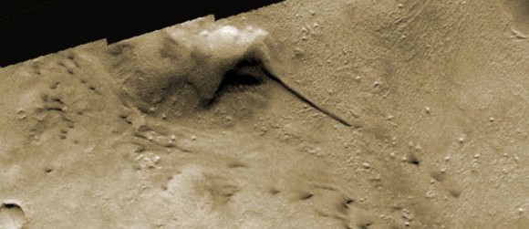
5. Rare Sighting Of A Dust-Covered Hummingbird
The head and long beak of a hummingbird is easy to imagine in this scene. I can’t say for sure how these features formed but wind and erosion no doubt played a part.
6. Hitchcockian Horror
Martian bird of prey or just another wayward pigeon?
7. Get It In Gear
The eroded blankets of ejecta blasted out when these craters formed look like a series of interlocking gears.
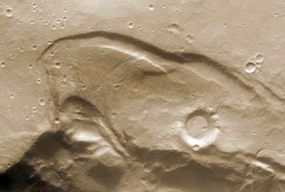
8. Lone Wolf On The Martian Prairie
Dark sand dune deposits look eerily like a howling wolf.
9. Thumbs Up!
These dunes remind me of a Minnesota “Thank you” for jump starting your car on a cold winter morning.
10. To A “T”
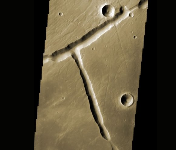
Tectonic stretching of the Martian crust created this unusual right-angle fracture. I wonder how many other letters of the alphabet we might find on the Red Planet?
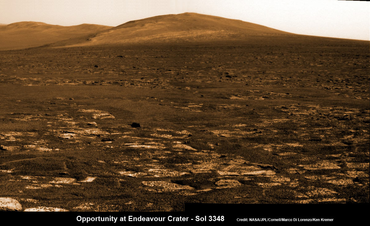
Opportunity rover’s view across Botany Bay to Solander Point - her next destination - as NASA celebrates 10 Years since blastoff for Mars on July 7, 2003. The rover will climb up Solander Point because it which may harbor clay minerals indicative of a past Martian habitable environment. This pancam mosaic was assembled from raw images taken on Sol 3348 (June 24, 2013. Credit: NASA/JPL/Cornell/ASU/Marco Di Lorenzo/Ken Kremer (kenkremer.com)
Opportunity rover’s view across Botany Bay to Solander Point – her next destination – as NASA celebrates 10 Years since blastoff for Mars on July 7, 2003. The rover will climb up Solander Point because it which may harbor clay minerals indicative of a past Martian habitable environment. This pancam mosaic was assembled from raw images taken on Sol 3348 (June 24, 2013.
Credit: NASA/JPL/Cornell/ASU/Marco Di Lorenzo/Ken Kremer (kenkremer.com)[/caption]
Today, NASA’sOpportunity rover marks a magical moment celebrating 10 years since launching to Mars on July 7, 2003 and with her impending Mountain destination filling the camera’s eye view.
The now legendary robot has vastly exceeded everyone’s expectations. Back in 2003 the science team promised us a mere 90 day ‘warranty’ following the suspenseful airbag landing on Jan. 24, 2004 at Meridiani Planum.
Today is Martian Day (or Sol) 3360. That amounts to a life expectancy and exploration ‘bonus’ of more than 37 times beyond the design lifetime.
Launch of NASA’s 2nd Mars Exploration Rover, Opportunity, aboard a Delta II Heavy rocket to Mars on July 7, 2003 at 11:18 p.m. EDT from Pad 17-B at Cape Canaveral Air Force Station, Fla. Credit: NASA
Opportunity’s twin sister Spirit blasted off three weeks earlier in June 2003 and continued functioning until 2010.
“I never thought we’d achieve nine months!” Principal Investigator Prof. Steve Squyres of Cornell University told me recently on the occasion of the rovers 9th anniversary on Mars in January 2013.
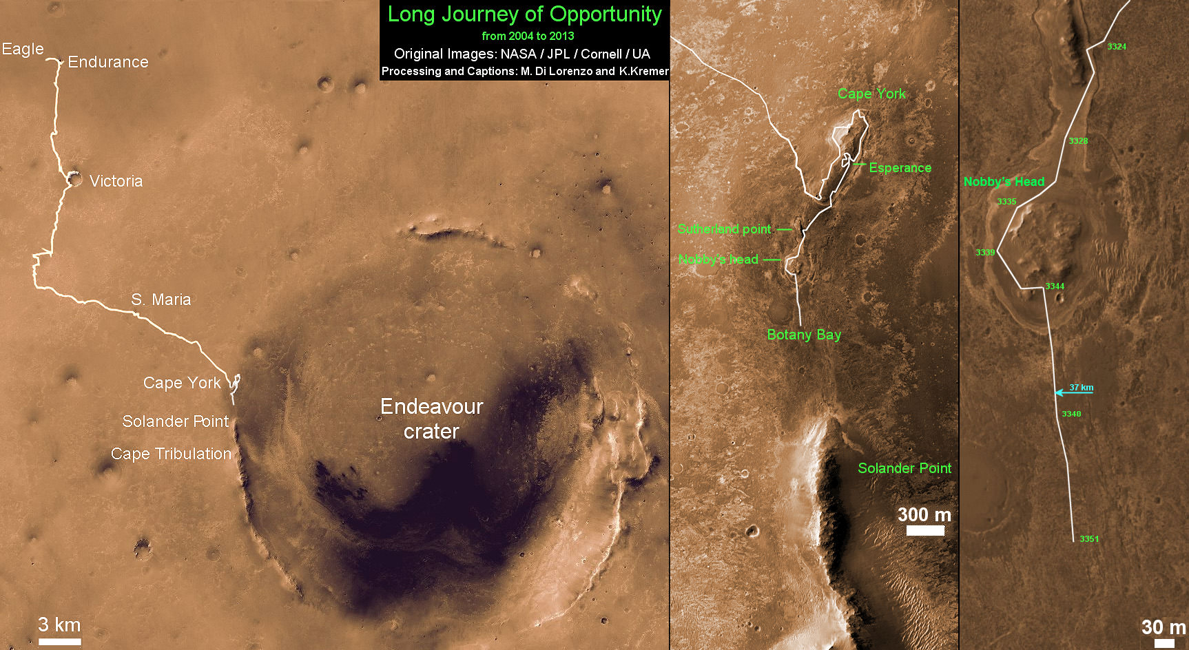
As you read this, the now decade old rover Opportunity is blazing a trail toward’s the oldest geological deposits she has ever explored – at a place called Solander Point, a raised ridge along the eroded rim of huge Endeavour Crater.
Opportunity has surpassed the halfway point in the traverse from the rim segment she has explored the past 22 months at ‘Cape York’ to her next rim segment destination at Solander.
From tip to tip, Cape York and Solander Point lie 1.2-mile (2-kilometer) apart along the western rim of Endeavour Crater. Both are raised portions of 14-mile-wide (22-kilometer-wide) Endeavour.
The rover has less than half a mile (800 meters) to go to finish the Martian dash from one rim segment to the next across an area called ‘Botany Bay’.
This view from July 2, 2013 (Sol 3355) shows the terrain that NASA’s Mars Exploration Rover Opportunity is crossing in a flat area called “Botany Bay” on the way toward “Solander Point,” which is visible on the horizon. Credit: NASA/JPL-Caltech
“We are making very good progress crossing ‘Botany Bay,’ said John Callas of NASA’s Jet Propulsion Laboratory, Pasadena, Calif., who is project manager for the mission now entering its 2nd decade.
The flat terrain of fractured, light-toned bedrock is devoid of treacherous dunes and is easy to drive across, almost like a highway, which simplifies the daily planning by the rovers Earthly handlers.
“The surface that Opportunity is driving across in Botany Bay is polygonally fractured outcrop that is remarkably good for driving,” said Brad Joliff, an Opportunity science team member and long-term planner at Washington University in St. Louis. “The plates of outcrop, like a tiled mosaic pavement, have a thin covering of soil, not enough to form the wind-blown ripples we’ve had to deal with during some other long treks. The outcrop plates are light-toned, and the cracks between them are filled with dark, basaltic soil and our old friends the ‘blueberries.”
The “blueberries” are hematite-rich, erosion-resistant concretions about the size of BB’s that Opportunity discovered when she first opened her eyes at her Eagle crater landing site. During the multi year crater hopping tour that ensued, the rover continued finding patches of blueberries all the way to Endeavour crater.
1st color panorama taken by Opportunity after landing inside Eagle Crater on Jan. 24, 2004. Credit: NASA/JPL/Cornell
Opportunity is expected to arrive at Solander’s foothills sometime in August – before the onset of the next southern hemisphere Martian winter, her 6th altogether.
Opportunity will scale Solander to continue the science quest in search of additional evidence of habitable environments with the chemical ingredients necessary to sustain Martian microbial life.
“Right now the rover team is discussing the best way to approach and drive up Solander,” Ray Arvidson told Universe Today. Arvidson is the mission’s deputy principal scientific investigator from Washington University in St. Louis, Mo.
‘Solander Point’ offers roughly about a 10 times taller stack of geological layering compared to ‘Cape York.’
Solander also offers north facing slopes where Opportunity’s solar wings can more effectively soak up the sun’s rays to generate life giving electrical power.
The robot remains in excellent health.
The total driving distance exceeds 23 miles (37 kilometers). She has snapped over 181,000 images.
Meanwhile on the opposite side of Mars at Gale Crater, Opportunity’s younger sister rover Curiosity also discovered a habitable environment originating from a time when the Red Planet was far warmer and wetter billions of years ago.
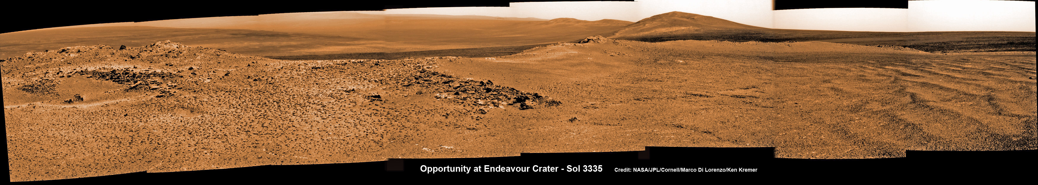
Opportunity captures spectacular panoramic view ahead to her upcoming mountain climbing goal, the raised rim of “Solander Point” at right, located along the western edge of Endeavour Crater. It may harbor clay minerals indicative of a habitable zone. The rise at left is “Nobbys Head” which the rover just passed on its southward drive to Solander Point from Cape York. This pancam photo mosaic was taken on Sol 3335, June 11, 2013 shows vast expanse of the central crater mound and distant Endeavour crater rim. Credit: NASA/JPL/Cornell/ASU/Marco Di Lorenzo/Ken Kremer (kenkremer.com) Traverse Map for NASA’s Opportunity rover from 2004 to 2013
This map shows the entire path the rover has driven during more than 9 years and over 3360 Sols, or Martian days, since landing inside Eagle Crater on Jan 24, 2004 to current location heading south to Solander Point from Cape York ridge at the western rim of Endeavour Crater. Credit: NASA/JPL/Cornell/ASU/Marco Di Lorenzo/Ken Kremer
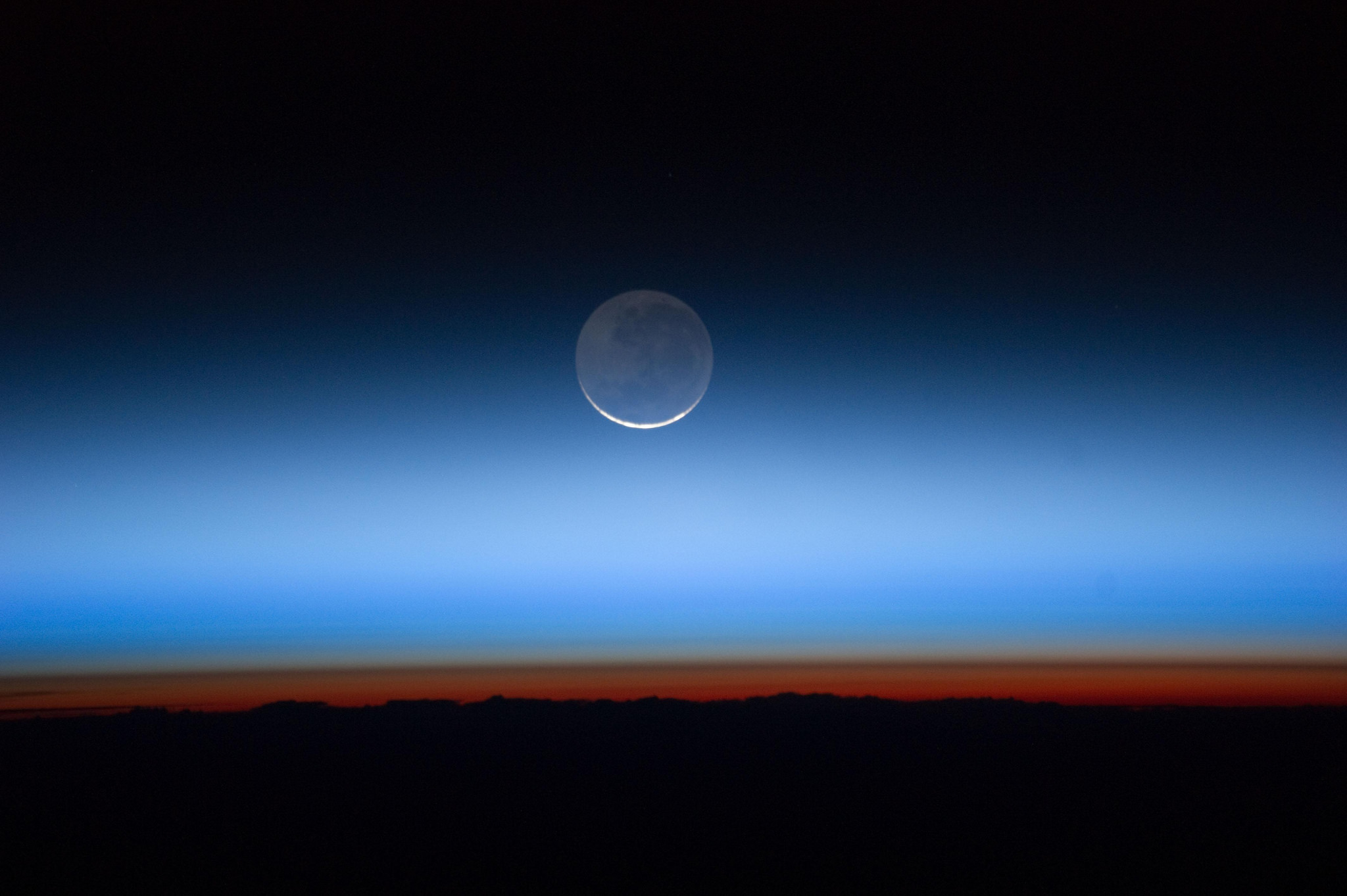
If you’re like me, you don’t change your computer’s desktop background nearly often enough… especially not considering all the fantastic space images that get released on an almost daily basis. But this picture, shared a couple of weeks ago by NASA’s Marshall Space Flight Center on their Flickr stream, really should inspire you to fix that. (I know it did for me!)
Captured by an Expedition 28 crew member aboard the International Space Station, this beautiful image shows a crescent-lit Moon seen through the upper layers of Earth’s atmosphere.
As it circles the globe, the ISS travels an equivalent distance to the Moon and back in about a day, making an excellent platform for viewing the Earth and its atmosphere. This photo shows the limb of Earth near the bottom transitioning into the orange-colored troposphere, the lowest and most dense portion of the Earth’s atmosphere. The troposphere ends abruptly at the tropopause, which appears in the image as the sharp boundary between the orange- and blue- colored atmosphere. Silvery-blue noctilucent clouds extend far above the Earth’s troposphere.
Expedition 28 began on May 23, 2011, with a crew consisting of Andrey Borisenko, Ron Garan, Alexander Samokutyaev, Sergei Volkov, Mike Fossum, and Satoshi Furukawa.
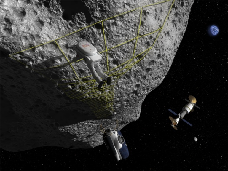
Landing on asteroids will be a risky endeavor, perhaps aggravated by changes in asteroid dust when it's touched. Credit: NASA Near Earth Object Program
Imagine plunking your spacecraft down on an asteroid. The gravity would be small. The surface would be uneven. The space rock might be noticeably spinning, complicating your maneuvering.
Humans have done it with robotic spacecraft before. The first time was in 2001, when NASA made a stunning landing with the NEAR Shoemaker spacecraft on Eros — using a craft that was not even designed to reach the surface. A new study, however, portrays getting close to these space rocks as perhaps even more hazardous than previously thought.
An experiment done aboard a “Vomit-Comet” like airplane, which simulates weightlessness, suggests that dust particles on comets and asteroids may be able to feel changes in their respective positions across far larger distances than on Earth.
“We see examples of force-chains everywhere. When you pick an orange from a pile in a supermarket, some come away easily, but others bring the whole lot crashing down. Those weight-bearing oranges are part of a force-chain in the pile,” stated Naomi Murdoch, a researcher at the Higher Institute of Aeronautics and Space (Institut Supérieur de l’Aéronautique et de l’Espace) in Toulouse, France.
Naomi Murdoch and Thomas-Louis de Lophem in a zero gravity environment aboard a parabolic airplane, alongside the AstEx experiment. Credit: A. Le Floc’h, ESA
“One important aspect of such chains is that they give a granular material a ‘memory’ of forces that they have been exposed to. Reversing the direction of a force can effectively break the chain, making the pile less stable.”
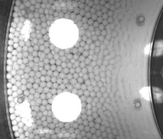
The Asteroid Experiment Parabolic Flight Experiment (AstEx) experiment was designed by Murdoch, Open University’s Ben Rozitis, and several collaborators from The Open University, the Côte d’Azur Observatory and the University of Maryland. It had a cylinder with glass beads inside of it, as well as a rotating drum at the heart.
Stacked photo of the grains in the Asteroid Experiment (AstEx). Credit: AstEx team
In 2009, when they were postgraduate students, Murdoch and Rozitis took their contraption on board an Airbus A300, which flew parabolas to simulate microgravity while the aircraft falls from its greatest height.
During this time, the inner drum spun up for 10 seconds and then the rotational direction was reversed. What happened was tracked by high-speed cameras. Later, the researchers analyzed the movement of the beads with a particle-tracking program.
The researchers found that particles at the edge of the cylinder (the closest analog to low-gravity environments) moved more than those in similar environments on Earth. Those closer to the center, however, were not as greatly affected.
“A lander touching down on the surface on one side of a small, rubble-pile asteroid could perhaps cause an avalanche on the other side, by long-range transmission of forces through chains It would, however, depend on the angle and location of the impact, as well as the history of the surface – what kind of memories the regolith holds,” said Murdoch.
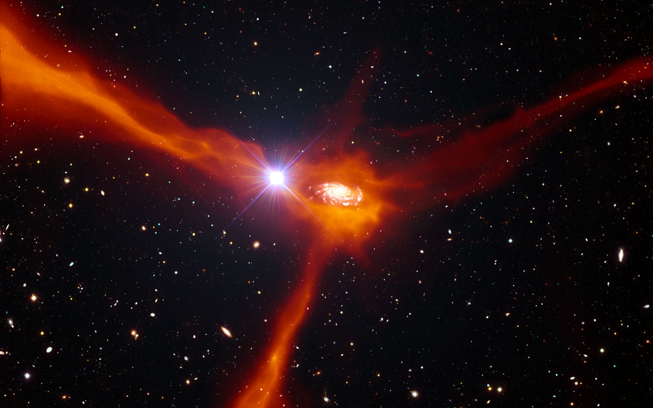
An artist’s impression showing a galaxy in the process of pulling in cool gas from its surroundings. (ESO/L. Calçada/ESA/AOES Medialab)
If you live in the U.S. you may be enjoying a sultry summer day off in honor of Independence Day, or at least have plans to get together with friends and family at some point to partake in some barbecued goodies and a favorite beverage (or three). And as you saunter around the picnic table scooping up platefuls of potato salad, cole slaw, and deviled eggs, you can also draw a correlation between your own steady accumulation of mayonnaise-marinated mass and a distant hungry galaxy located over 11 billion light-years away.
Astronomers have always suspected that galaxies grow by pulling in material from their surroundings, but this process has proved very difficult to observe directly. Now, ESO’s Very Large Telescope has been used to study a very rare alignment between a distant galaxy and an even more distant quasar — the extremely bright center of a galaxy powered by a supermassive black hole. The light from the quasar passes through the material around the foreground galaxy before reaching Earth, making it possible to explore in detail the properties of the in-falling gas and giving the best view so far of a galaxy in the act of feeding.
“This kind of alignment is very rare and it has allowed us to make unique observations,” said Nicolas Bouché of the Research Institute in Astrophysics and Planetology (IRAP) in Toulouse, France, lead author of the new paper. “We were able to use ESO’s Very Large Telescope to peer at both the galaxy itself and its surrounding gas. This meant we could attack an important problem in galaxy formation: how do galaxies grow and feed star formation?”
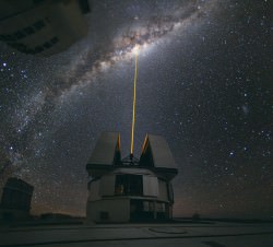
A beam from the Laser Star Guide on one of the VLT’s four Unit Telescopes helps to correct the blurring effect of Earth’s atmosphere before making observations (ESO/Y. Beletsky)
Galaxies quickly deplete their reservoirs of gas as they create new stars and so must somehow be continuously replenished with fresh gas to keep going. Astronomers suspected that the answer to this problem lay in the collection of cool gas from the surroundings by the gravitational pull of the galaxy. In this scenario, a galaxy drags gas inwards which then circles around it, rotating with it before falling in.
Although some evidence of such accretion had been observed in galaxies before, the motion of the gas and its other properties had not been fully explored up to now.
Astronomers have already found evidence of material around galaxies in the early Universe, but this is the first time that they have been able to show clearly that the material is moving inwards rather than outwards, and also to determine the composition of this fresh fuel for future generations of stars. And in this particular instance, without the quasar’s light to act as a probe the surrounding gas would be undetectable.
“In this case we were lucky that the quasar happened to be in just the right place for its light to pass through the infalling gas. The next generation of extremely large telescopes will enable studies with multiple sightlines per galaxy and provide a much more complete view,” concluded co-author Crystal Martin of the University of California Santa Barbara.
This research was presented in a paper entitled “Signatures of Cool Gas Fueling a Star-Forming Galaxy at Redshift 2.3”, to appear in the July 5, 2013 issue of the journal Science.
Look up into the night sky and count the moons. You can see only one moon, “the” Moon. But does the Earth have any other moons? Around the Solar System, multiple moons are the rule. Jupiter has 67 natural satellites, even Mars has two asteroid-like moons.
Could Earth have more than one?
Officially, the answer is no. The Earth has a single moon.
Today.
It’s possible Earth had more than one moon in the past, millions or even billions of years ago. Strange terrain on the far side of the Moon could be explained by a second moon crashing into it, depositing a layer of material tens of kilometers deep.
Moons could come and go over the billions of years of the Earth’s history.
For example, Mars has two Moons, but not for long. Phobos, the larger moon, is spiraling inward and expected to crash into the planet within the next 10 million years. And so, in the future, Mars will only have a single Moon, Deimos.
It’s also possible that the Earth might capture a Moon in the future. Neptune’s largest moon, Triton, orbits in the opposite direction from the rest of the moons around the planet. This suggests that Triton was actually a captured Kuiper Belt Object which strayed too close to the planet.
2006 RH120In fact, we did capture a 5-metre asteroid called 2006 RH120. It orbited the Earth four times during 2006/2007 before getting ejected again.
So we can assume events like this have happened in the past.
Additionally, we might have more moons, but they haven’t been discovered yet because they’re just too small. Researchers have calculated that there could be meter-sized asteroids in orbit around the Earth, remaining in orbit for hundreds of years before gravitational interactions push them out again.
And there are other objects that interact with Earth’s orbit in strange ways. Scientists don’t consider them moons, but they do stick around in our neighbourhood:
Asteroid 3753 Cruithne is in an orbital resonance with the Earth. It has a highly eccentric orbit, but takes exactly one year to orbit the Sun. From our perspective, it follows a slow, horse-shoe shaped path across the sky. Since the discovery of Cruithne in 1986, several other resonant near-Earth objects have been discovered.
2007 TK7There’s 2010 TK7, the Earth’s only known Trojan asteroid. It leads the Earth in the exact same orbit around the Sun, in a gravitationally stable point in space.
So, the answer… Earth only has a single Moon. Today. We might have had more moons in the past, and we might capture more in the future, but for right now… enjoy the one we’ve got.
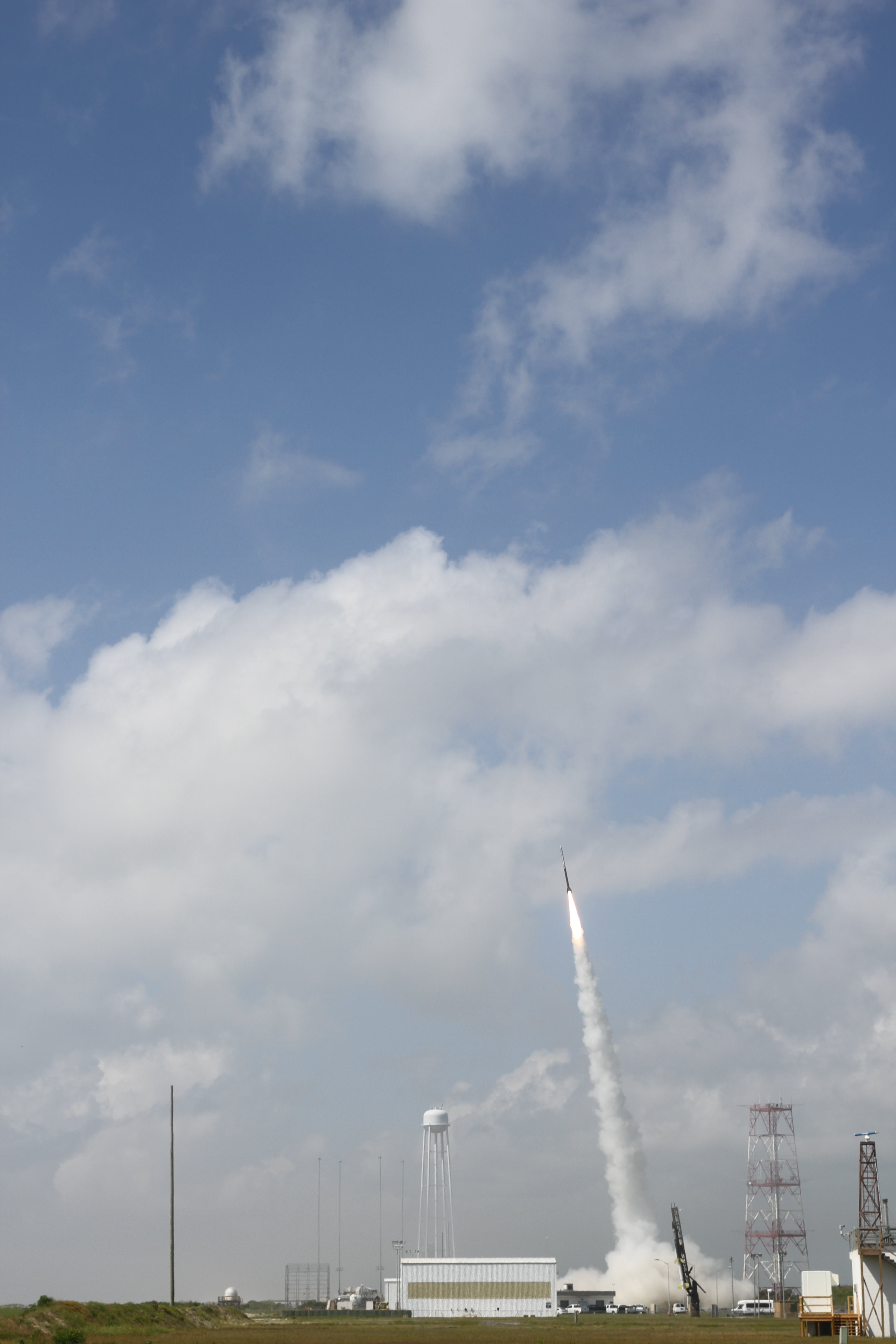
July 4 Morning Fireworks from NASA. A NASA Black Brant V Sounding Rocket launches in support of the Daytime Dynamo Mission on July 4, 2013 from NASA Wallops Flight Facility, VA, Credit NASA/J. Eggers
July 4 Morning Fireworks from NASA!
A NASA Black Brant V Sounding Rocket launches in support of the Daytime Dynamo Mission on July 4, 2013 from NASA Wallops Flight Facility, VA. Credit: NASA/J. Eggers[/caption]
WALLOPS ISLAND, VA – Today, July 4, NASA celebrated America’s Independence Day with a spectacular fireworks display of a dynamic duo of sounding rockets – blasting off barely 15 seconds apart this morning from the agencies NASA Wallops Island facility on the Eastern Shore of Virginia on a science experiment to study the ionosphere.
The goal of the two rocket salvo was an in depth investigation of the electrical currents in Earth’s ionosphere – called the Daytime Dynamo.
The Dynamo electrical current sweeps through the ionosphere, a layer of charged particles that extends from about 30 to 600 miles above Earth.
Disruptions in the ionosphere can scramble radio wave signals for critical communications and navigations transmissions that can impact our every day lives.
The launches suffered multiple delays over the past 2 weeks due to weather, winds, errant boats and unacceptable science conditions in the upper atmosphere.
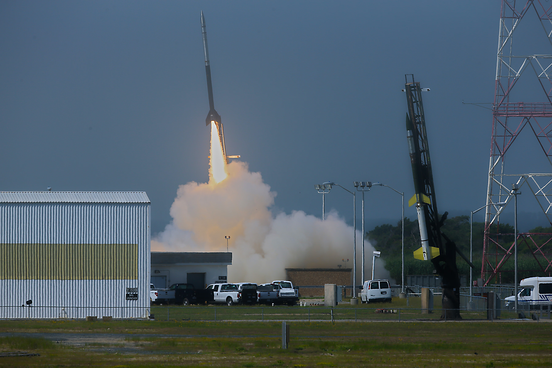
A Black Brant V launches first in support of Daytime Dynamo. Terroer improved Orion (at right) followed 15 seconds later from NASA Wallops on July 4, 2013. Credit: NASA/P. Black
At last, the Fourth of July was the irresistible charm.
The liftoff times were 10:31:25 a.m. for the Black Brant V and 10:31:40 a.m. (EDT) for the Terrier-Improved Orion.
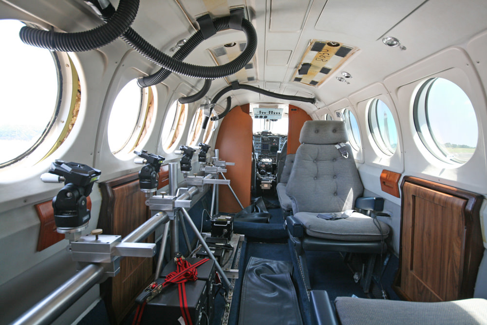
The experiment involved launching two suborbital rockets and also dispatching a NASA King Air airplane to collect a stream of airborne science measurements.
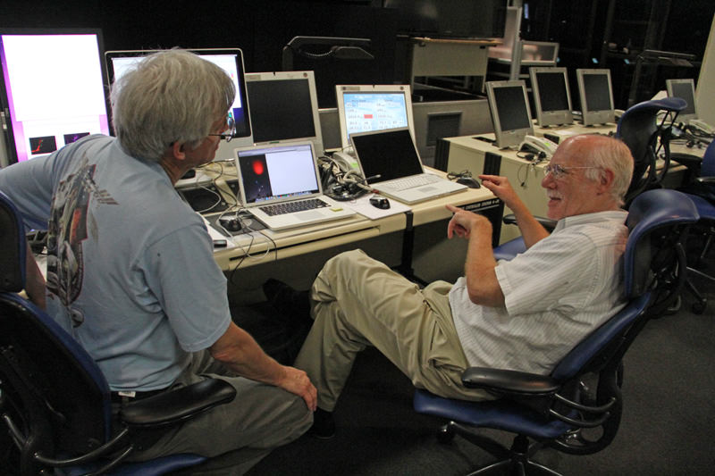
Daytime Dynamo is a joint project between NASA and the Japanese Space Agency, or Japan Aerospace Exploration Agency, or JAXA, said Robert Pfaff to Universe Today in an exclusive interview inside Mission Control at Wallops. Pfaff is the principle investigator for the Dynamo sounding rocket at NASA’s Goddard Space Flight Center in Greenbelt, Md.
“The dynamo changes during the day and varies with the season,” Pfaff told me.
But they only have one chance to launch. So the science team has to pick the best time to meet the science objectives.
“We would launch every month if we could and had the funding, in order to even more fully characterize the Dynamo.”
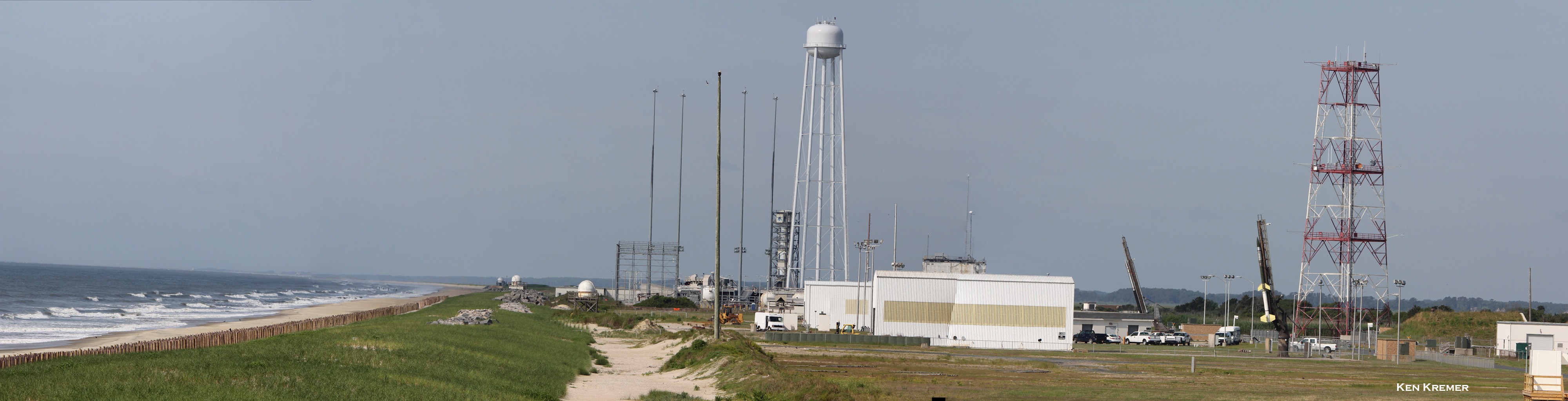
Two rocket salvo comprising a Black Brant V (left) and a Terrier-Improved Orion (right) sit ready to launch as part of the Daytime Dynamo mission in this panoramic view from NASA Wallops Flight Facility at Virginia’s Eastern Shore. Credit: Ken Kremer/kenkremer.com
The 35 foot tall single-stage Black Brant V launched first. It carried a 600 pound payload to collect the baseline data to characterize the neutral and charged ionospheric particles as it blasted skyward.
The 33 foot tall two-stage Terrier-Improved Orion took off just 15 seconds later in the wake of the exhaust of the Black Brant V.
Exhaust trails from Black Brant V and a Terrier-Improved Orion launched in support of Daytime Dynamo mission on July 4, 2013. Credit: NASA/P. Black
The Terrier-Improved Orion successfully deployed a lengthy trail of lithium gas from a pressurized canister that created a chemical tracer to track how the upper atmospheric winds vary with altitude. These winds are believed to be the drivers of the dynamo currents.
Both rockets fly for about five minutes to an altitude of some 100 miles up in the ionosphere. They both splashed down in the ocean after about 15 minutes.
NASA’s King Air aircraft was essential to the mission. I toured the airplane on the Wallops runway for an up-close look inside. It is outfitted with a bank of precisely aimed analytical instruments peering through the aircraft windows to capture the critical science data – see my photos herein.
“The King Air launches about an hour before the scheduled liftoff time,” Pfaff told me.
“It uses special cameras and filters to collect visible and infrared spectroscopic data from the lithium tracer to characterize the daytime dynamo.”
The science instruments are newly developed technology to make the daytime measurements of the lithium tracer and were jointly created by NASA, JAXA and scientists at Clemson University.
“Everything worked as planned,” Pfaff announced from Wallops Mission Control soon after the magnificent Fourth of July fireworks show this morning.
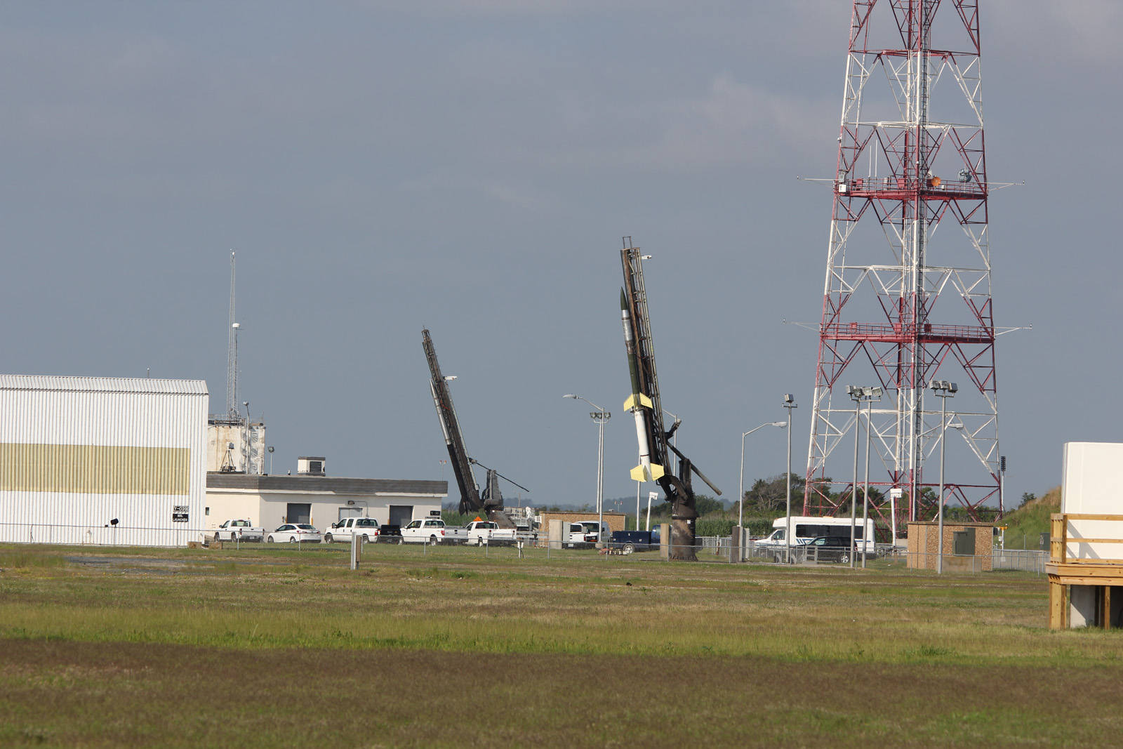
Black Brant V (left) and Terrier-Improved Orion (right) rockets sit on launch pads as part of the Daytime Dynamo mission in this up close view from NASA Wallops Flight Facility at Virginia’s Eastern Shore. Credit: Ken Kremer/kenkremer.comInside cabin view of NASA King Air aircraft outfitted with science instrument mounts to support a bank of cameras to capture visible and infrared spectroscopic measurements in support of Daytime Dynamic launches on July 4, 2013. Credit: Ken Kremer/kenkremer.comRobert Pfaff (right), Science Principle Investigator and Ken Kremer of Universe Today (left) discuss NASA’s Daytime Dynamo mission inside NASA Wallop’s Mission Control. Credit: Ken Kremer/kenkremer.com