Behind the Scenes at Kitt Peak Observatory: What is an Observing Run Really Like?

The view of Kitt Peak National Observatory, as seen from 1 mile below the summit.

Greetings, from the Kitt Peak National Observatory, in Arizona!  I’m here on a weeklong observing run, which is arguably the coolest and hardest part of the job.

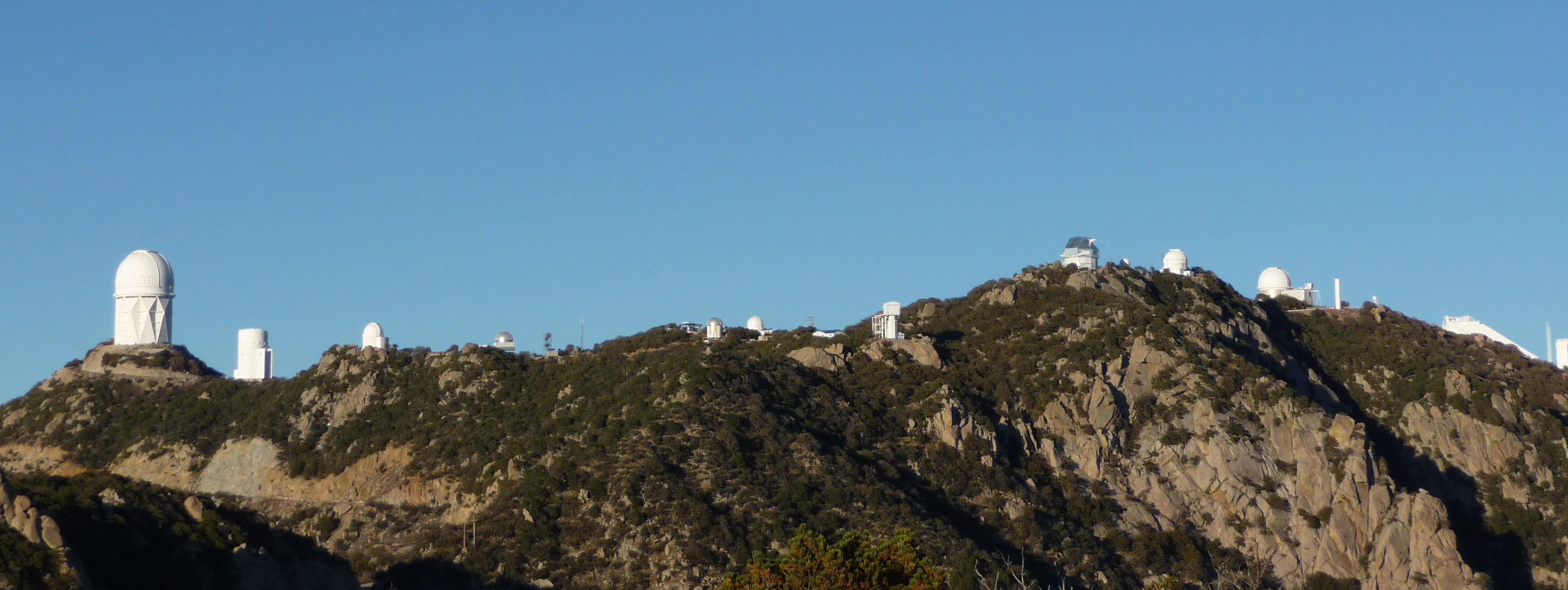
Kitt Peak rests on the Quinlan Mountains, 6,880 feet above sea level and 55 miles southwest of Tucson. When you begin your drive up the mountain, you first see a beautiful panorama of glittering white domes. There are 26 telescopes on the Mountain.

The Mayall 4-meter telescope quickly catches your eye – the colossal giant that towers over the rest.  As you continue your drive, a radio telescope can be seen on the left, followed by various signs stating that cell phone use is strictly prohibited. Observing runs here require radio silence, and a great chance to escape.

At the top of the mountain, two telescopes stand apart from the rest – the McMath-Pierce Solar Telescope and the WIYN observatory.  The solar telescope reflects sunlight through a tunnel that leads underground.  The WIYN observatory has an octagonal shape for a dome.

This is my third trip to Kitt Peak, but my first chance to observe on the Mayall 4-meter telescope. The first thing to know about the 4-meter is that it is a colossal maze. Literally.  There are 16 stories of rooms, now obsolete and out of date, before reaching the base of the telescope itself.

The dome of the 4-meter Mayall telescope (left) as well as the telescope itself (right)
The dome of the 4-meter Mayall telescope (left) as well as the telescope itself (right).

These rooms include old darkrooms, instrument rooms, machine rooms, classrooms, dormitories, game rooms, and other mysteries.  We’ve been joking most of this week that Hollywood should rent out the 4-meter for a fantastic horror film. Just think: The Big Bang Theory meets Psycho.

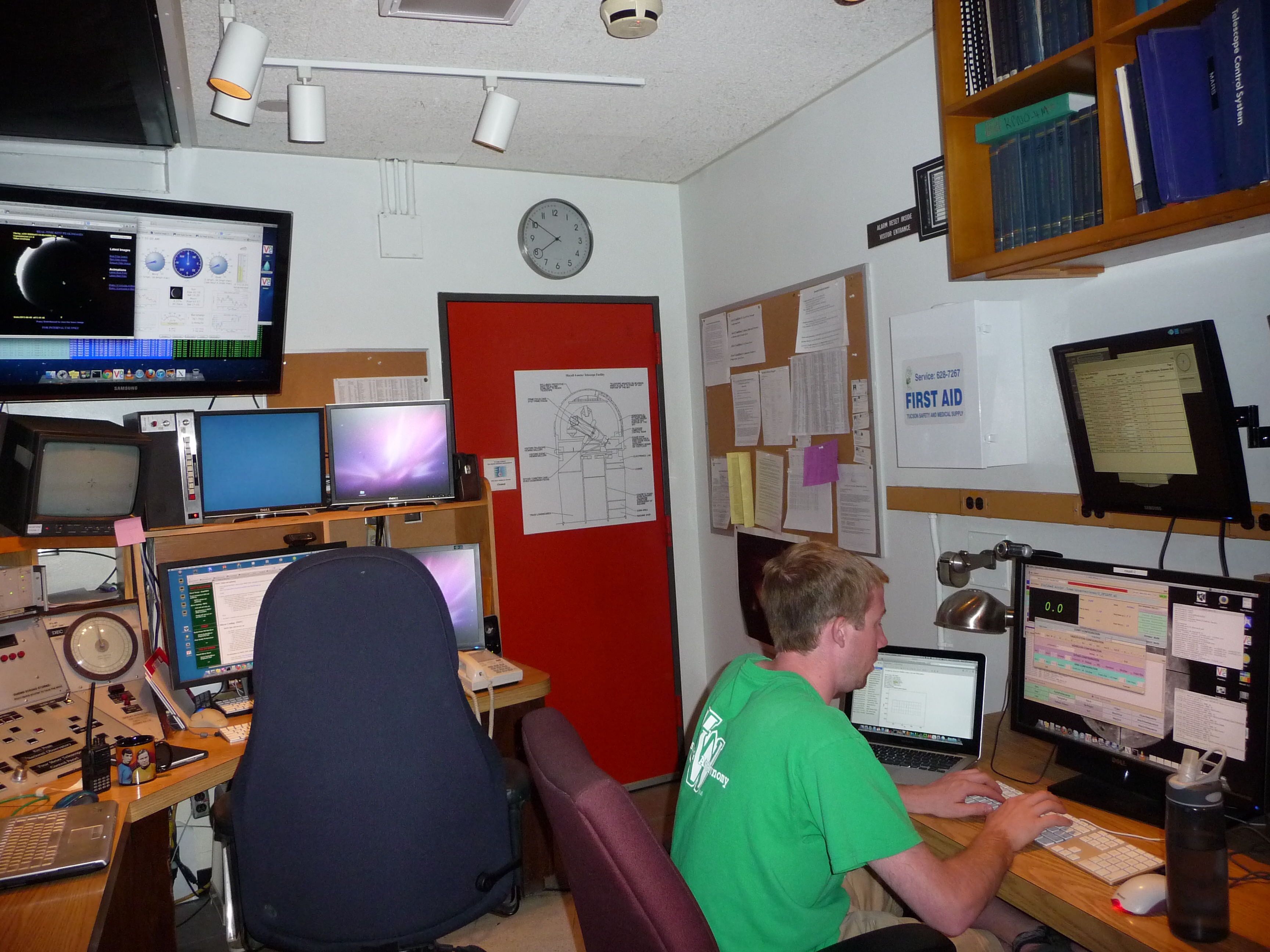
On our first day here, my colleague and I managed to get pretty lost. To reach the telescope you have to take two different gated and locked elevators.  But when we finally made it to the control room, we realized that this room alone is much more of maze than the building.

The control room consists of 4 computers, 16 monitors, 3 personal laptops, 4 tv screens, and an array of controls that operate the telescope. Eventually we became very comfortable floating from monitor to monitor.

The control room for the 4-m Mayall telescope. Dr. Mike DiPompeo is taking images.
The control room for the 4-m Mayall telescope. Dr. Mike DiPompeo is taking images throughout the night.

Here is what a typical day on an observing run looks like.

We typically wake up a little after noon and grumpily head to the dining hall for coffee.  Breakfast (or lunch) runs until about 1 pm.

In the late afternoon, we take a few flat field calibrations – images of a white screen, which is uniformly lit up. Any variations in the final image are due to variations in the detector or distortions in the optical path. At the end of the day, you can divide your science images by your flat field images, in order to achieve much cleaner images.

Shortly thereafter, the dewar is filled with liquid nitrogen.  This keeps the instrument cool (approximately -100 degrees Fahrenheit), as any thermal current can cause added noise.

After a quick dinner we return to the telescope.  At this point sunset is approximately 2 hours away, but it’s already time to open the dome. When you’re standing next to the telescope, an opening dome sounds like a freight train screeching to a stop.  It’s slightly terrifying, but it is by far one of my favorite sounds. It signifies that for the rest of the night you’re in control of this phenomenal instrument, which has the power to discover the secrets of the Universe.

After two hours of various preparations – making sure the telescope is pointing correctly, guiding correctly, etc. – we “get on sky.”  Throughout the night the telescope operator controls the telescope, moving it to the fields we would like to observe, while we are in charge of taking the images by verifying the exposure time, filters to use, etc.

If everything goes smoothly the night is pretty easy.  The telescope operator moves from target to target while we continuously take images. This means that we end up sitting in front of a computer screen, pressing enter every 300 seconds in order to start a new exposure. That’s really all it takes! Of course you should keep checking on your images in order to verify that they look good.

Around midnight it’s time for night lunch, a packed lunch that the dining hall provides.  A little extra protein helps make the long nights more bearable.  And then you push through, making coffee if necessary. The challenging part is staying awake throughout the night. It’s amazing how hard simple calculations can be when dawn is approaching.

At the end of the night you step outside and save for the flickering glint of Tucson’s city lights, the only noticeable light is found by looking up into the night sky.  The stars here are brilliant, and the Milky Way is astonishing. After spending an entire evening stuck in a black box, it’s a wonderful reminder of what it’s all about: the night sky.

I observed with Dr. Mike DiPompeo, who concurred on what I noticed about the observing experience.

“When you first get into astronomy you’re in awe of the beauty of the night sky, compelled and driven by it,” DiPompeo told me. “But it can be easy to forget in the day to day business of being an astronomer – sitting at a computer, writing code, going through the data, reading papers – that your job is to understand that beauty. Observing reconnects you with the night sky.”

My favorite part of an observing run occurs in the morning – on the walk from the telescope to the dorm, when a yellow arch of light first appears above the horizon. Kitt Peak provides fantastic sunrises. And you really have to soak in every last ray of sun, before you crawl into bed in a very dark room.

One of many beautiful sunrises.

Observing runs lie at the root of pure research.  You spend the long nights collecting data, then the months or years analyzing the data, and finally hope that a cool result comes from all the hard work.

This Energy-Boosting Region In The Sun Will Have A New NASA Satellite Watching It

IRIS will take a closer look at the lower parts of the sun's atmosphere, which is producing the spectacular flare shown in this image. Credit: NASA&JAXA/Hinode

How does the sun’s energy flow? Despite the fact that we live relatively close (93 million miles, or eight light-minutes) to this star, and that we have several spacecraft peering at it, we still know little about how energy transfers through the solar atmosphere.

NASA’s next solar mission will launch Wednesday, June 26 (if all goes to plan) to try to learn a little bit more. It’s called the Interface Region Imaging Spectrograph (IRIS), and it will zero in on a spot in the sun’s lower atmosphere known as the “interface region.” The zone only has a thickness of  3,000 to 6,000 miles and is seen as a key transfer point to the sun’s incredibly hot corona (that you can see during total solar eclipses.)

“IRIS will extend our observations of the sun to a region that has historically been difficult to study,” stated Joe Davila, IRIS project scientist at NASA’s Goddard Space Flight Center. “Understanding the interface region better improves our understanding of the whole corona and, in turn, how it affects the solar system.”

Figuring out more about the interface region, NASA stated, will teach us a lot more about the “space weather” that affects Earth.

Some of the energy in the interface region leaks out and powers the solar wind, which is a sort of rain of particles that leave the star. Some of them hit the Earth’s magnetic field and can produce auroras. Most of the sun’s ultraviolet radiation also flows from the interface region.

IRIS’ images will be able to zero in on about 1 percent of the sun in a single go, with resolution of features of as small as 150 miles. The 400-pound satellite will orbit Earth in an orbit perpetually keeping it above the sunrise line, a spot that lets the satellite look at the sun continuously for eight months without the sun being obscured by Earth.

It’ll also form part of a larger network of sun-staring satellites.

Technicians work on NASA’s Interface Region Imaging Spectrograph (IRIS) in a "clean room", a specially designed facility intended to minimize contaminants on spacecraft before launch. Credit: Lockheed Martin
Technicians work on NASA’s Interface Region Imaging Spectrograph (IRIS) in a “clean room”, a specially designed facility intended to minimize contaminants on spacecraft before launch. Credit: Lockheed Martin

NASA highlighted its Solar Dynamics Observatory and a joint mission it has with Japan, called Hinode, which both take images of the sun in high-definition. These other two observatories, however, look at different solar layers (specifically, the surface and the outer atmosphere).

With IRIS joining the fleet and looking at the interface region, it will provide a more complete picture.

“Relating observations from IRIS to other solar observatories will open the door for crucial research into basic, unanswered questions about the corona,” stated Davila.

Source: NASA

‘Super Moon’ Images from Around the World, June 2013

The perigee 'Super Moon' of June 23, 2013 (21:43 PHT) over Marikina City, Philippines compared to the apogee Moon of November, 2012. Credit and copyright: Raven Yu.

The full Moon of June 23, 2013 was the largest Moon of the year. This so-called “Super Moon” was at perigee — or at its closest point in its orbit to Earth, and was 14% bigger and 30% brighter than other full Moons of 2013.

But, if you looked up at the Moon last night and didn’t know about this, you may not have noticed! Some claims circulating on the internet tended to exaggerate how large the Moon would actually appear. However, that doesn’t mean the Moon wasn’t photogenic last night! The Moon is always a great target for photography or just gazing with your own eyes, and these images from Universe Today readers attest to the beauty of our closest companion in the night sky.

This lead image from Raven Yu from the Philippines shows the difference in size between last night’s perigee Moon and the apogee Moon (when it was farthest from Earth during its orbit) last November.

If you want to find out more about the science of the perigee Super Moon, read our detailed article here.

See more beautiful images, below!

Three different views of the Moon over Italy during the night of June 23, 2013 helps debunk the optical illusion of the Moon looking bigger when it's low on the horizon. Credit and copyright: Giuseppe Petricca.
Three different views of the Moon over Italy during the night of June 23, 2013 helps debunk the optical illusion of the Moon looking bigger when it’s low on the horizon. Credit and copyright: Giuseppe Petricca.

Three different pictures of the Moon from June 23, shared by Guiseppe Petricca from Italy, detailing not only the perigee Super Moon, but the ‘Moon Illusion” — of how the Moon looks bigger when it is close to the horizon.

“The middle one is the Moon at culmination in the local sky and the other two are taken as low as possible my local horizon permitted,” Guiseppe said via email. “Doing this, I managed to obtain two results: the first one is observing the different colours that due to the Rayleigh Scattering, ‘paint’ our satellite, when it’s low on its elevation. The second one is that, keeping a fixed magnification (24x – 110mm) one can easily debunk the optical illusion of the ‘bigger moon when it’s low on the horizon’. Since, if you observe carefully, the lower two ‘Moons’ are smaller than the higher one. However, the total personal experience is surely wonderful!! And the ‘horizon illusion’ makes you really think that the Moon is way bigger that the reality.”

The Supermoon rising on June 23rd, 22:40 pm above the forest canopy top in Puerto Rico. This is a 6 panel mosaic. Credit and copyright: Efrain Morales, Jaicoa Observatory.
The Super Moon on June 23, 2013 as seen over Malta. Credit and copyright: Leonard E. Mercer.
The perigee 'Super Moon' of June 23, 2013 as seen over Sesimbra, Portugal and the church Nossa Senhora do Castelo.  Credit and copyright: Miguel Claro.
The perigee ‘Super Moon’ of June 23, 2013 as seen over Sesimbra, Portugal and the church Nossa Senhora do Castelo. Credit and copyright: Miguel Claro.

Miguel Claro captured this beautiful image of the huge full Moon rising above a Moorish castle in Sesimbra, Portugal. “The church Nossa Senhora do Castelo stands on the spot where king Sancho I built a Romanesque chapel in the early 13th century,” Miguel said via email. “This image was captured 2 km away from the subject.” Miguel used a Canon 50D – ISO640; 1/80 sec. + ED80 APO refractor Astro Professional 560mm at f/7 taken on 23/06/2013 at 21h22.

The perigee Super Moon of June 23, 2013 as seen over São Paulo, Brazil. Time: 01:40 UTC, using a  Maksutov Cassegrain Vixen 110 mm - F = 1035 mm - F/9.4 - Plano Focal - Nikon D3100 - 1/80 - ISO 200. Credit and copyright: Ednilson Oliveira.
The perigee Super Moon of June 23, 2013 as seen over São Paulo, Brazil. Time: 01:40 UTC, using a Maksutov Cassegrain Vixen 110 mm – F = 1035 mm – F/9.4 – Plano Focal – Nikon D3100 – 1/80 – ISO 200. Credit and copyright: Ednilson Oliveira.
An early image of the perigee Super Moon -- the Moon setting the morning of June 23, 2013 just after 5 a.m. EDT over Toronto, Canada.  ‘As I understand it perigee occurred between 7:11 - 7:13 a.m. EDT, so this was my ‘launch window’ to 'Shoot the Perigee Moon'. The atmosphere was thick with haze which dimmed the Moon substantially and allowed the surface maria to be photographed.’ Credit and copyright: Rick Ellis.
An early image of the perigee Super Moon — the Moon setting the morning of June 23, 2013 just after 5 a.m. EDT over Toronto, Canada. ‘As I understand it perigee occurred between 7:11 – 7:13 a.m. EDT, so this was my ‘launch window’ to ‘Shoot the Perigee Moon’. The atmosphere was thick with haze which dimmed the Moon substantially and allowed the surface maria to be photographed.’ Credit and copyright: Rick Ellis.
The perigee Super Moon rising over the floodwaters of the Bow River during a record flood that inundated many parts of southern Alberta around rivers, including here on the Siksika First Nations reserve. Credit and copyright: Alan Dyer/Astronomy Calgary/Amazing Sky Photography.
A 3-photo HDR image of the supermoon rising over downtown Tucson, Arizona. During the longer exposure the Moon gave out its own flare due to its intensity. Credit and copyright: Sean Parker/Sean Parker Photography.
The full perigee Moon rising on June 23, 2013. Credit and copyright: Sculptor Lil on Flickr.
Full Moon Rising Over Northwest Georgia on June 22nd, 2013. Credit and copyright: Stephen Rahn.
The perigee Super Moon on June 23, 2013, taken with a Skywatcher ED80 Refractor and a Canon 600D at prime focus. Best 20 of 40 images stacked in Registax 6. False colour removed as the Moon appeared dull red as it was so low in sky. Credit and copyright: James Lennie.
The view of June 23rd 2013 Supermoon from Trinidad and Tobago, West Indies (Caribbean). Credit and copyright: Apple Lilly. (This image is the right size to fit a Facebook cover image, the photographer says).

You can see more great images of this perigee Super Moon — and lots more great astrophotography at our Flickr group page.

Want to get your astrophoto featured on Universe Today? Join our Flickr group or send us your images by email (this means you’re giving us permission to post them). Please explain what’s in the picture, when you took it, the equipment you used, etc.

NASA’s Daytime Dynamo Experiment Deploys Lithium to Study Global Ionospheric Communications Disruptions

On June 24, 2013 a pair of daytime sounding rockets will launch from NASA Wallops Flight Facility (WFF) and deploy a chemical trail like the one deployed here from a sounding rocket at night. The chemical trail will help researchers track wind movement to determine how it affects the movement of charged particles in the atmosphere. All the colors in the sky shown here, the white and blue streaks, and the larger red blob overhead, are from the chemical trails. Credit: NASA

On June 24, 2013 a pair of daytime sounding rockets will launch from NASA Wallops Flight Facility (WFF) and deploy a chemical trail like the one deployed here from a sounding rocket at night. The chemical trail will help researchers track wind movement to determine how it affects the movement of charged particles in the atmosphere. All the colors in the sky shown here, the white and blue streaks, and the larger red blob overhead, are from the chemical trails. Credit: NASA
See Rocket Visibility Maps below[/caption]

NASA WALLOPS, VA – Science and space aficionados are in for rare treat on June 24 when NASA launches a two-rocket salvo from the NASA Wallops Flight Facility, Va. on a mission to study how charged particles in the ionosphere can disrupt communication signals that impact our day to day lives.

It’s a joint project between NASA and the Japanese Space Agency, or Japan Aerospace Exploration Agency, or JAXA.

The suborbital sounding rockets will blast off merely 15 seconds apart from a beach-side launch complex directly on Virginia’s Eastern shore on a science mission named the Daytime Dynamo.

An electric current called the dynamo, illustrated here, sweeps through Earth’s upper atmosphere. A sounding rocket called Dynamo will launch in the summer of 2013 to study the current, which can disrupt Earth’s communication and navigation signals. Credit: USGS
An electric current called the dynamo, illustrated here, sweeps through Earth’s upper atmosphere.A pair of sounding rockets called Dynamo will launch on June 24, to study the current, which can disrupt Earth’s communication and navigation signals. Credit: USGS
Lithium gas will be deployed from one of the rockets to create a chemical trail that can be used to track upper atmospheric winds that drive the dynamo currents.

The goal is to study the global electrical current called the dynamo, which sweeps through the ionosphere, a layer of charged particles that extends from about 30 to 600 miles above Earth.

Why should you care?

Because disruptions in the ionosphere can scramble radio wave signals for communications and navigations transmissions from senders to receivers – and that can impact our every day lives.

The experiment involves launching a duo of suborbital rockets and also dispatching an airplane to collect airborne science measurements.

Mission control and the science team will have their hands full coordinating the near simultaneous liftoffs of two different rockets with two different payloads while watching the weather to make sure its optimal to collect the right kind of data that will answer the research proposal.

A single-stage Black Brant V will launch first. The 35 foot long rocket will carry a 600 pound payload to collect the baseline data to characterize the neutral and charged particles as it swiftly travels through the ionosphere.

Visibility map for Black Brant V rocket launch on June 24 at 9:30 a.m.  Credit: NASA Wallops
Visibility map for Black Brant V rocket launch on June 24 at 9:30 a.m. Credit: NASA Wallops

A two-stage Terrier-Improved Orion blasts off just 15 seconds later. The 33 foot long rocket carries a canister of lithium gas. It will shoot out a long trail of lithium gas that creates a chemical trail that will be tracked to determine how the upper atmospheric wind varies with altitude. These winds are believed to be the drivers of the dynamo currents.

Visibility map for Terrier-Improved Orion rocket launch on June 24 at 9:30 a.m.  Credit: NASA Wallops
Visibility map for Terrier-Improved Orion rocket launch on June 24 at 9:30 a.m. Credit: NASA Wallops

Both rockets will fly for about five minutes to an altitude of some 100 miles up in the ionosphere.

Since its daytime the lithium trails will be very hard to discern with the naked eye. That’s why NASA is also using a uniquely equipped NASA King Air airplane outfitted with cameras with special new filters optimized to detect the lithium gas and how it is moved by the winds that generate the global electrical current.

The new technology to make the daytime measurements was jointly developed by NASA, JAXA and scientists at Clemson University.

RockOn 2013 University student payload blasts off on June 20,2013 atop a NASA Terrier-Improved Orion suborbital rocket from NASA Wallops at Virginia’s eastern shore. Credit: NASA/Chris Perry

Sounding rockets are better suited to conduct these studies of the ionosphere compared to orbiting satellites which fly to high.

“The manner in which neutral and ionized gases interact is a fundamental part of nature,” said Robert Pfaff, the principle investigator for the Dynamo sounding rocket at NASA’s Goddard Space Flight Center in Greenbelt, Md.

“There could very well be a dynamo on other planets. Jupiter, Saturn, Uranus and Neptune are all huge planets with huge atmospheres and huge magnetic fields. They could be setting up dynamo currents galore.”

The launch window opens at 9:30 a.m. and extends until 11:30 a.m. Back up opportunities are available on June 25 and from June 28 to July 8.

The rockets will be visible to residents in the Wallops region – and also beyond to the US East Coast from parts of North Carolina to New Jersey.

The NASA Wallops Visitor Center will open at 8 a.m. on launch day for viewing the launches.

Live coverage of the June 24 launch is available via NASA Wallops UStream beginning at 8:30 a.m. at: http://www.ustream.tv/channel/nasa-tv-wallops

I will be onsite at Wallops for Universe Today.

And don’t forget to “Send Your Name to Mars” aboard NASA’s MAVEN orbiter- details here. Deadline: July 1, 2013. Launch: Nov. 18, 2013

Ken Kremer

…………….
Learn more about Earth, Mars, Curiosity, Opportunity, MAVEN, LADEE, Sounding rockets and NASA missions at Ken’s upcoming presentation

June 23: “Send your Name to Mars on MAVEN” and “CIBER Astro Sat, LADEE Lunar & Antares Rocket Launches from Virginia”; Rodeway Inn, Chincoteague, VA, 8 PM

Show here are the two types of sounding rockets that will launch on June 24, 2013 from NASA Wallops Island, VA., on the Daytime Dynamo mission. Black Brant V rocket is horizontal. Terrier-Improved Orion rocket is vertical. Credit: Ken Kremer
Show here are the two types of sounding rockets that will launch on June 24, 2013 from NASA Wallops Island, VA., on the Daytime Dynamo mission. Black Brant V rocket is horizontal. Terrier-Improved Orion rocket is vertical. Credit: Ken Kremer – kenkremer.com
Night time launch of NASA Black Brant XII suborbital rocket at 11:05 p.m. EDT on June 5, 2013 from the NASA Wallops Flight Facility carrying the CIBER astronomy payload. Credit: Ken Kremer- kenkremer.com

Herbal Earth: Spectacular Vegetation Views of Our Home Planet and the Natural World of Living Green Life

Earth’s Vegetation. World map of vegetation created with Suomi NPP data. Credit: NASA/NOAA

Earth’s Vegetation from Suomi NPP satellite. World map of vegetation data collected by the Suomi NPP satellite (National Polar-orbiting Partnership) in a partnership between NASA and the National Oceanic and Atmospheric Administration (NOAA). Credit: NASA/NOAA
Photo and Video Gallery below[/caption]

Herbal Earth: that’s the title of a spectacular collection of vivid new views of the Earth’s vegetation captured over the past year by the Suomi NPP satellite.

NPP is short for National Polar-orbiting Partnership – an Earth science satellite partnership between NASA and the National Oceanic and Atmospheric Administration (NOAA).

Although it’s rather reminiscent of the manmade ‘World at Night’ – its actually the ‘Natural World of Living Green Life.’

The Suomi NPP satellite data were collected with the Visible-Infrared Imager/Radiometer Suite (VIIRS) instrument from April 2012 to April 2013 and used to generate this gallery of images and animations – released by NASA and NOAA on June 19.

Western Hemisphere -Vegetation on Our Planet. The darkest green areas are the lushest in vegetation, while the pale colors are sparse in vegetation cover either due to snow, drought, rock, or urban areas. Suomi NPP Satellite data from April 2012 to April 2013 was used to generate these images. Credit: NASA/NOAA

Suomi NPP was launched on October 28, 2011 by a Delta II rocket and placed into a sun-synchronous orbit 824 km (512 miles) above the Earth. It orbits Earth about 14 times daily.

The VIIRS instrument measures vegetation changes over time by looking at changes in the visible and near-infrared light reflected by vegetation. The 22-band radiometer sensor can detect subtle differences in greenness.

Nile Delta: July 9-15, 2012.  Amidst the deserts of Egypt, the Nile River provides life-sustaining water to the region. Also visible are the urbanized areas of northern Egypt. Credit: NOAA/NASA
Nile Delta: July 9-15, 2012. Amidst the deserts of Egypt, the Nile River provides life-sustaining water to the region. Also visible are the urbanized areas of northern Egypt. Credit: NASA/NOAA

The data are incorporated into the Normalized Difference Vegetation Index (NDVI) which represents the photosynthetic potential of vegetation.

The NVDI measures and monitors plant growth, vegetation cover and biomass production from the Suomi NPP satellite information.

The Florida Everglades: March 18-24, 2013. The "river of grass" extending south of Lake Okeechobee shows clear signs of its modified state with areas of dense agriculture, urban sprawl and water conservation areas delineated by a series of waterways that crisscross Southern Florida.  Credit: NOAA/NASA
The Florida Everglades: March 18-24, 2013. The “river of grass” extending south of Lake Okeechobee shows clear signs of its modified state with areas of dense agriculture, urban sprawl and water conservation areas delineated by a series of waterways that crisscross Southern Florida. Credit: NASA/NOAA

A quarter of the Earth’s surface is covered by some green vegetation, the remainder is the blue ocean.

Video: Green- Vegetation on Our Planet (Tour of Earth)

And don’t forget to “Send Your Name to Mars” aboard NASA’s MAVEN orbiter- details here. Deadline Very Soon: July 1, 2013. Launch: Nov. 18, 2013

Ken Kremer

…………….
Learn more about Earth, Mars, Curiosity, Opportunity, MAVEN, LADEE and NASA missions at Ken’s upcoming presentation

June 23: “Send your Name to Mars on MAVEN” and “CIBER Astro Sat, LADEE Lunar & Antares Rocket Launches from Virginia”; Rodeway Inn, Chincoteague, VA, 8 PM

Eastern Hemisphere -Vegetation on Our Planet. Credit: NASA/NOAA

Feeling Small in the Universe?

Well, you shouldn’t be. Yes, you’re just one person out of over 7 billion on Earth. Yes, your lifetime — even if you live to be well over 100 — is just a fraction of a flicker of a blink of a tardigrade’s eye (do tardigrades blink?) compared to the 4.6 billion years of the age of the planet. And yes, Earth is only about a third the age of the Universe… which is filled with billions of other galaxies each with stars and planets of their own. Space is just so awfully darn…big.

But, as astrophysicist Neil deGrasse Tyson reminds us in the video above, so are you. So is everyone, in fact. And why? Because we are all a part of it. We’re a part of the Universe… each one of us an inexorably inseparable part of the big picture, a connection between past, present, and future in the most elemental sense possible. As Tyson famously stated once before, “we are in the Universe, the Universe is in us.” And it’s true.

So if you have an admittedly large and heavy ego, put it down for a moment and check out the video. You may come to realize it was weighing you down a bit.

“Those who see the cosmic perspective as a depressing outlook, they really need to reassess how they think about the world.”

– Neil deGrasse Tyson

Video: Big Think

Amazing Shots! Shenzhou-10 Docked to Tiangong-1, Transiting the Sun

Solar transit of the Chinese space station Tiangong-1 with the Shenzhou-10 module docked, taken from Southern France on June 16, 2013 at 12:14:50 UTC; using a white light filter. Credit and copyright: Thierry Legault.

As soon as you see these images, you’ll probably guess who the photographer is … yes, Thierry Legault. He had less than half a second to capture these incredible shots of the Shenzhou-10 module docked to Tiangong-1 Chinese station transiting across the Sun, and it he did it not only once, but twice, on two consecutive days. Can you see the tiny spacecraft among the sunspots? And keep in mind, there are three taikonauts in these images as well, as the Shenzou has been docked to the Chinese space station module since June 11!

The Tiangong-1 space station is just 10.4 meters (34.1 ft) in length, while the Shenzou 10 is 9.25 meters (30.35 ft) long. This top image is a crop of a full-face view of the Sun, (see the full-face view on Thierry’s website) taken with white light filters by Thierry from southern France on June 16, just after noon UTC. The transit duration was just 0.46 seconds, and Thierry calculated the distance of the spacecraft to observer was 365 km away, and the spacecraft was traveling at 7.4km/s (26,500 km/h or 16,500 mph).
He used a Takahashi TOA-150 refractor, Baader Herschel prism and Canon 6D (1/4000s, 100 ISO).

Below is another solar transit of the two Chinese spacecraft, also taken from Southern France, but the next day, June 17, 2013 at 12:34:24 UTC. This one, in Hydrogen-alpha shows the Shenzhou-10/Tiangong-1 complex in multiple shots over the 0.46 second transit.

Hydrogen-alpha solar transit of Shenzhou-10 module docked to Tiangong-1, taken from Southern France on June 17, 2013 at 12:34:24 UT. Credit and copyright: Thierry Legault.

For this image, Thierry used his Takahashi FSQ-106, Coronado SM90 double stack, camera IDS CMOSIS 4Mp sensor at 38 fps.

This isn’t the first time Thierry has trained his cameras on the Tiangong-1 – in May of 2012 he captured the tiny space station alone transiting the Sun, and it was dwarfed by a huge sunspot sported by the Sun at the time.

In a previous interview with Universe Today, Thierry explained how he prepares to take images like these:

For transits I have to calculate the place, and considering the width of the visibility path is usually between 5-10 kilometers, but I have to be close to the center of this path,” Legault explained, “because if I am at the edge, it is just like a solar eclipse where the transit is shorter and shorter. And the edge of visibility line of the transit lasts very short. So the precision of where I have to be is within one kilometer.”

Legault studies maps, and has a radio synchronized watch to know very accurately when the transit event will happen.

“My camera has a continuous shuttering for 4 seconds, so I begin the sequence 2 seconds before the calculated time,” he said. “I don’t look through the camera – I never see the space station when it appears, I am just looking at my watch!”

He uses CalSky to make his calculations and figure out the timing.

Congrats to Thierry and our thanks to him for sharing his amazing images and skills with Universe Today!

Diagram of Shenzhou-10 (right) docked with Tiangong-1 (left). Via Wikimedia Commons.

Space Art Show Comes Out To Play In L.A., With NASA’s ‘Mohawk Guy’ As Special Guest

SPACE! The Gallery Show will feature space-themed art such as this piece by Joe Van Wetering. Credit: SPACE! The Gallery Show

Space fans in Los Angeles — and we know, given Mars Curiosity is controlled at the nearby NASA Jet Propulsion Laboratory, that there are lots of you — here’s a neat-looking art show for you to check out in the next month.

SPACE! The Gallery Show will open at Gallery 1988: West today with special NASA guest Bobak Ferdowsi, a systems engineer at JPL who is best known as “Mohawk Guy” — that person with the great haircut being shown on television screens worldwide during the Curiosity landing.

“You guys, I am thrilled to finally share this with you,” wrote organizer Mike Mitchell on his blog. “It’s the first time I’ve ever curated a show, and it’s a theme that I’m very passionate about. Take a gander at the artist list, get yourself pumped up and come to the show. It’s going to be a stellar time.”

The event runs today through Saturday, July 20, closing on the 44th anniversary of the Apollo 11 landing. More information is available on the event’s Facebook page and the gallery’s website.

Hat-tip to Laughing Squid, whose post alerted us to the show.

New Horizons Spacecraft ‘Stays the Course’ for Pluto System Encounter

The Pluto and Charon Binary Planet System imaged by the Hubble Space Telescope. NASA’s New Horizons spacecraft will pass through in 2015 using the original baseline trajectory . Credit: Hubble Space Telescope

Following an intense 18 month study to determine if NASA’s New Horizons spacecraft faced potentially destructive impact hazards during its planned 2015 flyby of the Pluto binary planet system, the mission team has decided to ‘stay the course’ – and stick with the originally planned trajectory because the danger posed by dust and debris is much less than feared.

The impact assessment study was conducted because the Pluto system was discovered to be much more complex – and thus even more scientifically compelling – after New Horizons was launched in January 2006 from Cape Canaveral in Florida.

Two years ago researchers using the iconic Hubble Space Telescope discovered two new moons orbiting around Pluto, bringing the total to 5 moons!

It was feared that debris hitting the moons could have created dangerous dust clouds that in turn would slam into and damage the spacecraft as it zoomed past Pluto at speeds of some 30,000 miles per hour (more than 48,000 kilometers per hour) in July 2015.

“We found that loss of the New Horizons mission by dust impacting the spacecraft is very unlikely, and we expect to follow the nominal, or baseline, mission timeline that we’ve been refining over the past few years,” says New Horizons Project Scientist Hal Weaver, of the Johns Hopkins University Applied Physics Laboratory, in a statement.

After both the team and an independent review board and NASA thoroughly analyzed the data, it was determined that New Horizons has only a 0.3 percent chance of suffering a mission destroying dust impact event using the baseline trajectory.

Hubble Space Telescope view of Pluto and its known moons.

The 0.3 percent probability of mission loss is far less than some earlier estimates.

This is really good news because the team can focus most of its efforts on developing the flyby encounter science plan when New Horizons swoops to within about 12,500 kilometers (nearly 7,800 miles) of Pluto’s surface.

Pluto forms a “double planet” system with Charon, its largest moon. Charon is half the size of Pluto.

But the team will still expend some effort on developing alternative trajectories – known as SHBOTs, short for Safe Haven by Other Trajectories, just in case new information arises from the ships camera observations that would force a change in plans as New Horizons sails ever closer to Pluto.

“Still, we’ll be ready with two alternative timelines, in the event that the impact risk turns out to be greater than we think,” says Weaver.

Indeed the team, led by Principal Investigator Alan Stern, of the Southwest Research Institute is finalizing the encounter plan this month and plans a rehearsal in July of the most critical nine-day segment of the baseline flyby trajectory.

New Horizons will perform the first reconnaissance of Pluto and Charon in July 2015. The “double planet” is the last planet in our solar system to be visited by a spacecraft from Earth.

And New Horizons doesn’t’ stop at Pluto. The goal is to explore one or more of the icy Kuiper Belt Objects (KBO’s) further out in the Solar System.

The team will use the Pluto flyby to redirect New Horizons to a KBO that is yet to be identified.

And don’t forget to “Send Your Name to Mars” aboard NASA’s MAVEN orbiter- details here. Deadline: July 1, 2013. Launch: Nov. 18, 2013

Ken Kremer

…………….
Learn more about Pluto, Mars, Curiosity, Opportunity, MAVEN, LADEE and NASA missions at Ken’s upcoming lecture presentations

June 23: “Send your Name to Mars on MAVEN” and “CIBER Astro Sat, LADEE Lunar & Antares Rocket Launches from Virginia”; Rodeway Inn, Chincoteague, VA, 8 PM

Where Are All the Aliens? The Fermi Paradox

Where Are All The Aliens?

Consider this. The Universe is enormous.

There are as many as four-hundred billion stars in our galaxy: the Milky Way. And there are more than one-hundred-and-seventy billion galaxies in the observable Universe. Most of those stars have planets, and many of those planets have got to contain useful minerals and fall within their star’s habitable zone where liquid water is present.

The conditions for life are probably everywhere.

But where are all the aliens?

And think about this.

The Universe has been around for 13.8 billion years. Human beings originated 200,000 years ago, so we’ve only been around for 0.01% of the age of the Universe. An intelligent species could arise on any one of those countless worlds, and broadcast their existence to the entire galaxy.

Once a species developed interstellar travel, they could completely colonize our galaxy within a few tens of millions of years; just a heartbeat in the age of the Universe.

So where are they?

As far as we know, Earth is the only place in the Universe where life has arisen, let alone developed an intelligent civilization.

This baffling contradiction is known as the Fermi Paradox, first described in 1950 by the physicist Enrico Fermi.

Scientists have been trying to resolve this mystery for decades, listening for radio signals from other worlds. We’ve only sampled a fraction of the radio spectrum, and so far, we haven’t detected anything that could be a signal from an intelligent species.

How can we explain this?

Maybe we really are the only planet in the entire Universe to develop life. Maybe we’re the first civilization to reach this level of advancement in the entire galaxy. But with so many worlds out there, that really seems unlikely.

Artist impression of an asteroid impact on early Earth (credit: NASA)
Maybe civilizations destroy themselves when they reach a certain point. Nuclear weapons, global warming, killer epidemics, and overpopulation could all end humanity. Asteroids could strike the planet and wipe us out. But would this happen to every single civilization? one-hundred-percent of them? Even if ninety-nine-percent of civilizations destroy themselves, we’d still have a couple that made it through and fully colonized the galaxy.

Maybe they’re just too far away, and our signals can’t reach each other. But then, self-replicating probes could traverse those distances and leave a local artifact in every single star system.

Maybe we can’t understand their signals or recognize their artifacts. Maybe, but if aliens constructed a series of artifacts on Earth, I think we’d notice them. The aliens would have experience creating obvious structures.

Maybe they’re just too alien and we just can’t understand them. Maybe we’re too insignificant, and they don’t think we’re even worth talking to. We don’t need to talk to them to know they exist. If they flew through our Solar System, ignoring us, we’d still know they’re around.

Maybe they’re not talking to us on purpose, and we’re really in some kind of galactic zoo. Or aliens have a Prime Directive, and they’re not allowed to talk to us. Again, all the aliens? Not a single one has gotten through and snuck us some evidence?

Milky Way. Image credit: NASA

There are many other potential solutions to the Fermi Paradox, but I personally find them all insufficient. The Universe is big, and old, and if extraterrestrial life is anything like us, it wants to multiply and spread out.

Perhaps the most unsettling thought is that something happens to 100% of intelligent civilizations that prevents them from exploring and settling the galaxy. Maybe something good, like the discovery of a transportation system to another Universe. Or maybe something bad, like a destructive technology that has destroyed every single civilization before us.

How do you feel about the Fermi Paradox? How do you resolve the contradictions? Whatever the solution, it’s really fun to think about.

We’ve recorded a couple of episodes of Astronomy Cast about the Drake Equation and the Fermi Paradox, and we did a sequel episode called, Solutions to the Fermi Paradox.