Photographer Graham Gaunt recently spent a week on the beautiful island of St. Agnes, Isle of Scilly during an unusual stretch of clear weather. “I spent every night awake dragging my gear out at dusk and returning to sleep at dawn,” Graham wrote on Vimeo. “No matter how much I thought I had planned out each shot the unraveling of the nights events always brought new and different surprises.”
Thanks to Graham for capturing and sharing his wonderful night views and experiences!
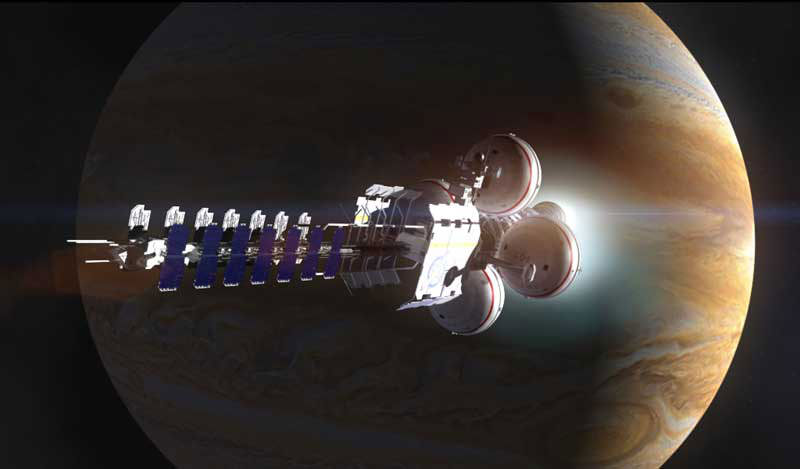
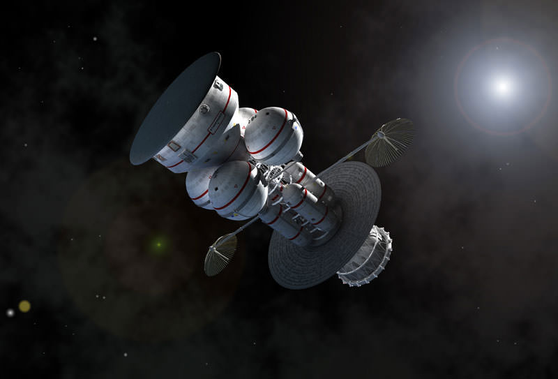
A spacecraft makes a close pass by Jupiter. Credit: Adrian Mann
Picture the scene: It’s the not too distant future and humanity has started to construct colonies and habitats all across our solar system. We’re gearing up to take that next big step into the unknown – actually leaving the cozy protection of the Sun’s heliosphere and venturing into interstellar space. Before this future can happen, however, there’s an important thing which is often overlooked in discussions on this subject.
Navigation.
Just as sailors once used the stars to navigate the sea, space travelers may be able to use the stars to navigate the solar system. Except that this time, the stars we’d use will be dead ones. A specific class of neutron stars known as pulsars, defined by the repeated pulses of radiation they emit. The trick, according to a recent paper, may be to use pulsars as a form of interplanetary – and possibly even interstellar – GPS.
Theories and ideas on spacecraft engines are plentiful. Foundations such as Icarus Interstellar keenly advocate the development of new propulsion systems, with some systems such as the VASIMR thrusters appearing rather promising. Meanwhile, fusion rockets are expected to be able to take passengers on a round trip from Earth to Mars in just 30 days, and researchers elsewhere are working on real life warp drives, not unlike the ones we all know and love from the movies.
Interplanetary GPS
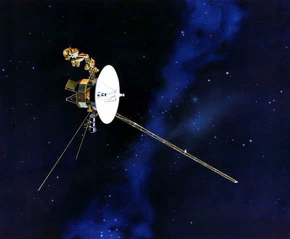
For Voyager 2, out on the edge of our Solar system, conventional navigation methods don’t work too well. Credit: NASA
But navigation is just as important. After all, space is mind-meltingly vast and mostly empty. The prospect of getting lost out in the emptiness is, frankly, terrifying.
To date, this hasn’t really been a problem, particularly seeing as we’ve only sent a small handful of craft past Mars. As a result, we currently use a messy mishmash of techniques to keep track of spacecraft from here on Earth – essentially tracking them with telescopes while relying heavily on their planned trajectory. This is also only as accurate as our instruments here on Earth are, meaning that as a craft gets more distant, our idea of where exactly it is becomes increasingly less accurate.
This is all well and good when we only have a few craft to track, but when space travel becomes more easily attainable and human passengers are involved, routing everything through Earth will start to become more and more difficult. This is particularly the case if we’re planning on leaving the confines of our home star – Voyager 2 is presently over 14 light hours away, meaning that Earth-based transmissions take over half a day to reach it.
Navigating Earth with modern technology is quite simple thanks to the array of GPS satellites we have in orbit around our world. Those satellites are constantly transitting signals which are, in turn, received by the GPS unit you may have on your car dashboard or in your pocket. As with all other electromagnetic transmissions, those signals travel at the speed of light, giving a slight delay between when they were transmitted and when they’re received. By using the signals from 4 or more satellites and timing those delays, a GPS unit can pinpoint your location on the surface of Earth with remarkable accuracy.
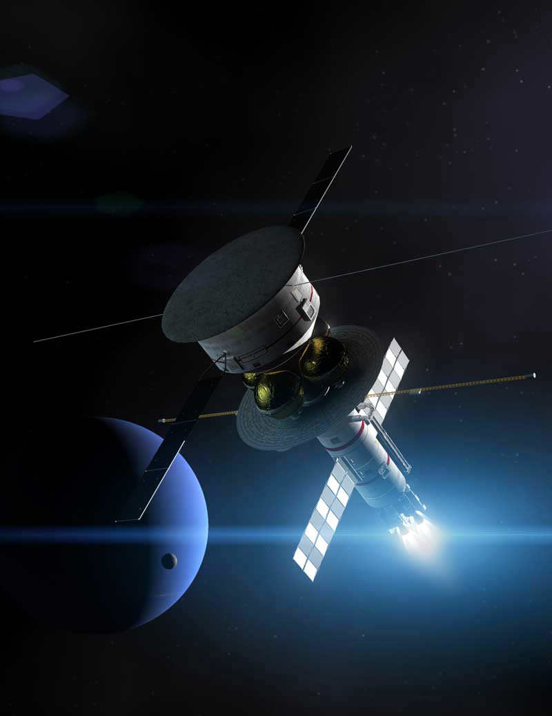
The Icarus Pathfinder starship passing by Neptune. Credit: Adrian Mann
The pulsar navigation system proposed by Werner Becker, Mike Bernhardt, and Axel Jessner at the Max Planck Institute, works in a very similar way, using the pulses emitted by pulsars. By knowing the initial position and velocity of your spacecraft, recording those pulses, and treating the Sun as a fixed reference point, you can calculate your exact location inside the solar system.
Considering the Sun to be fixed this way is technically referred to as an inertial reference frame, and if you compensate for the motion of the Sun through our galaxy, the system still works perfectly well when leaving the Solar system! All you need is to keep track of a minimum of 3 pulsars (ideally 10, for the most accurate results), and you can pinpoint your location with surprising accuracy!
Interestingly enough, the idea of using pulsars as navigation beacons dates all the way back to 1974, notably not long after Carl Sagan had used pulsars to show Earth’s location on the plaques attached to the Pioneer 10 and 11 space probes. If Project Daedalus had ever been constructed, it might have been equipped with a system not unlike the one described here.
Packing for long haul
Becker and his colleagues looked at the different types of pulsar visible in the sky, and picked out a type known as rotation-powered pulsars as the best type to use for a galactic positioning system. In particular, a sub-type of these known as millisecond pulsars are ideal. Being older than most pulsars they have weak magnetic fields, meaning they take a long time to slow down their spin rates – helpful as strongly magnetised pulsars can sometimes change their rotation speed without warning.
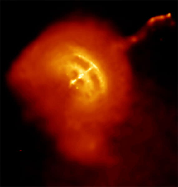
An x-ray image of the Vela pulsar, one of the brightest known millisecond pulsars. Credit: NASA/CXC/PSU/G.Pavlov et al.
With countless pulsars to choose from, the question turns to how you might equip your spacecraft to track them. Pulsars are easiest to spot in either x-rays or radio waves, so there’s a little choice as to which may be better to use. Essentially, it all turns out to be a question of how large your spacecraft is.
Smaller vehicles, more akin to modern spacecraft, would be best off using x-rays to track pulsars. X-ray mirrors, like the ones used in certain orbiting space telescopes are compact and lightweight, meaning that a few could be added for a navigation system without increasing the overall mass of the craft all that much. They may have the minor disadvantage that they may be easily damaged by an x-ray source which is too bright, this wouldn’t be a problem except under some unfortunate circumstances.
On the other hand, if you’re piloting a large space ship between planets or even stars, you would likely be better using radio waves. In radio frequencies, we know a lot more about the way in which pulsars work, as well as being able to measure them with a higher degree of accuracy. The only drawback there is that the radio telescopes you’d need to install on your ship would require an area of at least 150 m². But then, if you happened to be flying a starship, that kind of size probably wouldn’t make much difference.
It’s interesting to bear in mind the way that astronomers frequently use the analogy of pulsars being “like lighthouses” when explaining why they appear to pulse. If we someday find ourselves using them as actual navigation aids, that analogy may take on a whole new meaning!
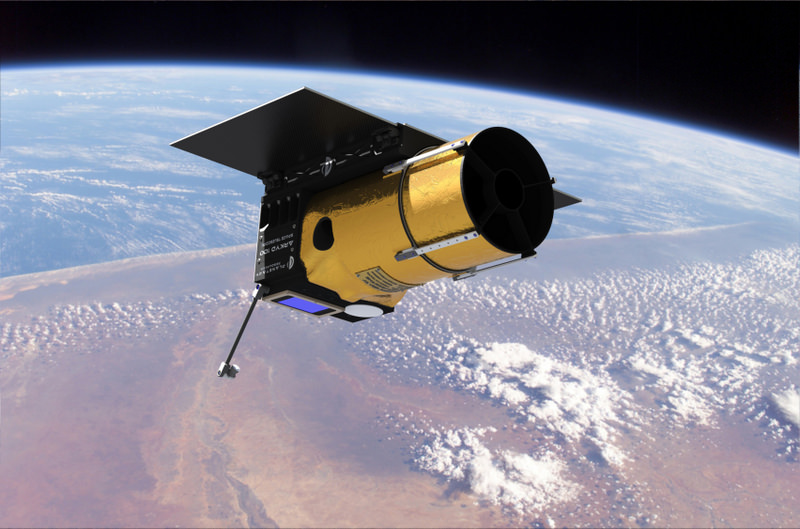
Artist concept of the Arkyd telescope in space. Credit: Planetary Resources Inc.
With more than $1 million in crowdfunded money secured for a public asteroid-hunting space telescope, the ultimate question arises: what about the promised planet chase?
Planetary Resources’ Arkyd-100 telescope reached its $1 million goal yesterday (June 20). But the self-proclaimed asteroid-hunting company has an ambitious aim to add extrasolar planet searching to the list if it can double that goal to $2 million.
The Kickstarter campaign for Arkyd still has 10 days remaining. To keep the funds flowing, the group behind it has released several “stretch” goals if it can reach further milestones:
– $1.3 million: A ground station at an undisclosed “educational partner” that would double the download speed of data from the orbiting observatory.
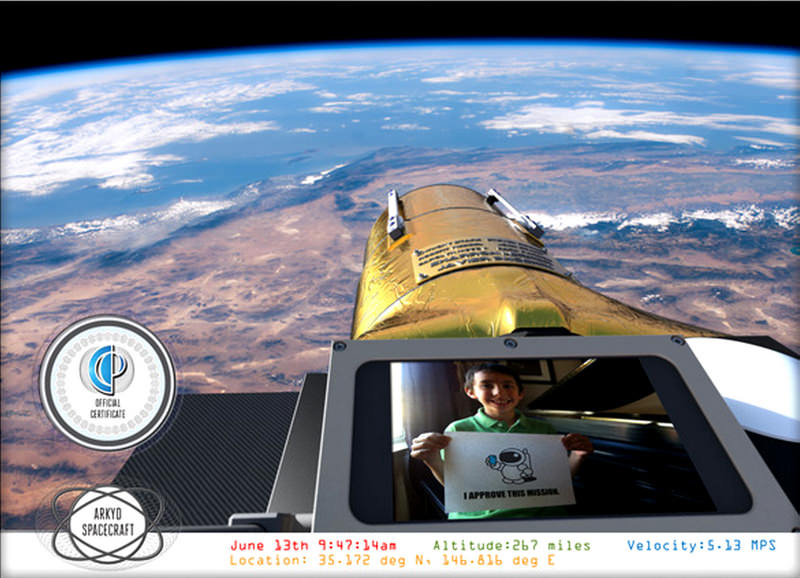
Example of an orbital ‘selfie’ that Planetary Resources’ ARKYD telescope could provide to anyone who donates to their new Kickstarter campaign. Credit: Planetary Resources.
– $1.5 million: This goal, just released yesterday, is aimed at the more than 20,000 people who signed up for “space selfies” incentive where uploaded pictures are photographed on the telescope while it is in orbit. For this goal, “beta selfies” will be taken while the telescope is in the integration phase of the build.
– $1.7 million: The milestone will be announced if Arkyd reaches 15,000 backers. (It has more than 12,000 as of this writing.)
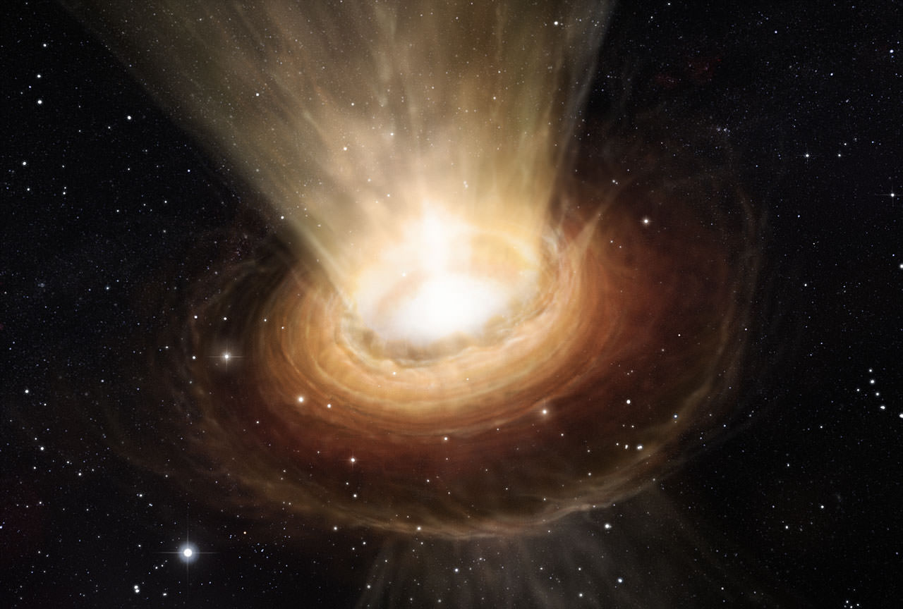
This artist’s impression shows the surroundings of the supermassive black hole at the heart of the active galaxy NGC 3783 in the southern constellation of Centaurus (The Centaur). Credit: ESO/M. Kornmesser
Over the years, researchers have taken myriad observations of black holes and their environs, but now ESO’s Very Large Telescope Interferometer is giving us the most detailed look of the dust around a black hole at the center of an active galaxy ever obtained. Originally expected to be contained within the ring-shaped torus around the black hole, the observation held a surprise as astronomers discovered that a significant amount of the dust was located both above and below the torus. What can this mean? According to the latest findings and contrary to popular theory, it is possible the dust is being evacuated from the region as a cool wind.
For the last two decades, astronomers have discovered that nearly all galaxies harbor a black hole at their hearts. In many cases, these monsters increase in size by accreting matter from the immediate vicinity. This, in turn, is responsible for the creation of active galactic nuclei (AGN), one of the most energetic objects in the Universe. Surrounding the super-luminous giants are rings of cosmic dust which originate from space – drawn in like water swirling down a dark drain. According to theory, the intense infrared radiation exerted by AGN must have originated from these dusty eddies.
Thanks to the powerful eye of the Very Large Telescope Interferometer (VLTI) at ESO’s Paranal Observatory in Chile, astronomers have now seen something new in a nearby active galaxy cataloged as NGC 3783. While they observed the expected hot dust clocking in at some 700 to 1000 degrees Celsius, what they also observed confounded them… Huge amounts of cooler dust both above and below the main torus.
As Sebastian Hönig (University of California Santa Barbara, USA and Christian-Albrechts-Universität zu Kiel, Germany), lead author of the paper presenting the new results, explains, “This is the first time we’ve been able to combine detailed mid-infrared observations of the cool, room-temperature dust around an AGN with similarly detailed observations of the very hot dust. This also represents the largest set of infrared interferometry for an AGN published yet.”
Is this a black hole teething ring? From their observations, the researchers suspect the newly-discovered dust is flowing outward from the central black hole. This means the wind most likely plays a critical part in the tangled relationship of both the black hole and its surroundings. Apparently the black hole pulls immediate material into it, but the incredible amount of radiation this produces also seems to be pushing it away. Scientists are far from clear as to how these two processes work together, but the discovery of this dusty wind could lead to a better understanding of their evolution.
To get the resolution needed to study the core area of NGC 3783, astronomers needed to use the combined power of the Unit Telescopes of ESO’s Very Large Telescope. Through this union, an interferometer is created – one capable of “seeing” with the equivalent of a 130-meter telescope.
Another team member, Gerd Weigelt (Max-Planck-Institut für Radioastronomie, Bonn, Germany), explains, “By combining the world-class sensitivity of the large mirrors of the VLT with interferometry we are able to collect enough light to observe faint objects. This lets us study a region as small as the distance from our Sun to its closest neighbouring star, in a galaxy tens of millions of light-years away. No other optical or infrared system in the world is currently capable of this.”
What do these new observations mean to the world of astronomy? It might very well change the pattern of how we currently understand AGN. With proof that dust is being expelled by intense radiation, new models must be created – models which include this recent information of how dust can be distributed.
Hönig concludes, “I am now really looking forward to MATISSE, which will allow us to combine all four VLT Unit Telescopes at once and observe simultaneously in the near- and mid-infrared — giving us much more detailed data.” MATISSE, a second generation instrument for the VLTI, is currently under construction.
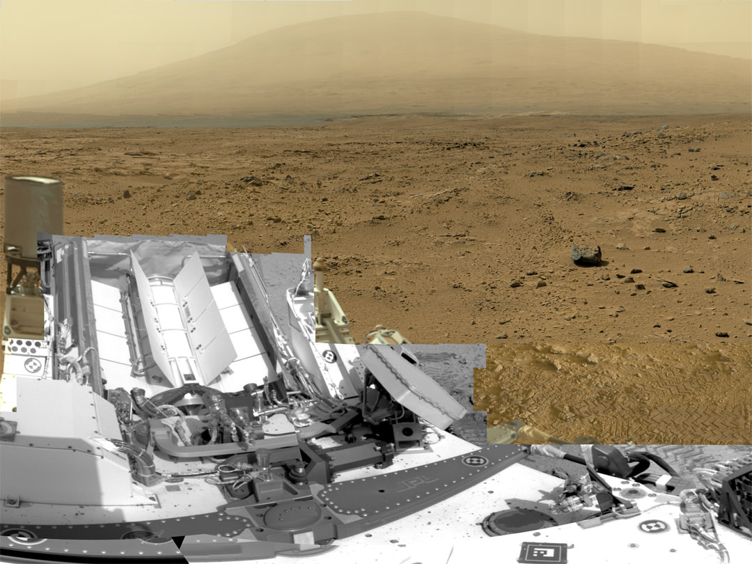
This is a cropped, reduced version of panorama from NASA's Mars rover Curiosity with 1.3 billion pixels in the full-resolution version see full panorama below. It shows Curiosity at the "Rocknest" site where the rover scooped up samples of windblown dust and sand. Curiosity used three cameras to take the component images on several different days between Oct. 5 and Nov. 16, 2012. Viewers can explore this image with pan and zoom controls at http://mars.nasa.gov/bp1/. Credit: NASA/JPL-Caltech/MSSS
This is a cropped, reduced version of panorama from NASA’s Mars rover Curiosity with 1.3 billion pixels in the full-resolution version. See full panorama below. It shows Curiosity at the “Rocknest” site where the rover scooped up samples of windblown dust and sand. Curiosity used three cameras to take the component images on several different days between Oct. 5 and Nov. 16, 2012. Viewers can explore this image with pan and zoom controls at http://mars.nasa.gov/bp1/. Credit: NASA/JPL-Caltech/MSSS Updated with link to interactive Gigapan version
[/caption]
NASA’s newly produced and absolutely spectacular panorama from the Curiosity mega rover offers armchair explorers back on Earth a mammoth 1.3 billion pixels worth of Mars in all its colorful glory.
And everyone can move back and forth around the interactive panorama and zoom in – with special embedded tools- to your hearts delight in exquisite detail at the ‘Rocknest’ site where the rover spent her first extended science stay in late 2012.
This extra special Rocknest panorama is the first NASA- produced view comprising more than a billion pixels from the surface of the Red Planet.
It offers a full 360 degree panoramic view around the rover encompassing breathtaking vistas of Mount Sharp and the eerie rim of Gale Crater, some 20 miles distant.
Mount Sharp rises 3.4 miles (5.5 km) high and is the target destination. The team hopes Curiosity will arrive at the base of Mount Sharp perhaps late this year or early in 2014.
The ‘Rocknest’ scene was assembled from nearly 900 raw images snapped by three different cameras among the 17 total that Curiosity uses as she trundles across the crater floor in search of the ingredients of life.
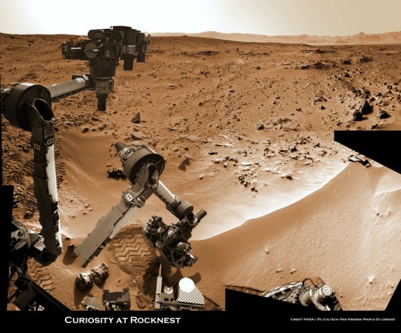
Billion-Pixel View From Curiosity at Rocknest, Raw Color. This full-circle, reduced view combined nearly 900 images taken by NASA’s Curiosity Mars rover, generating a panorama with 1.3 billion pixels in the full-resolution version. The view is centered toward the south, with north at both ends. It shows Curiosity at the “Rocknest” site where the rover scooped up samples of windblown dust and sand. Curiosity used three cameras to take the component images on several different days between Oct. 5 and Nov. 16, 2012. Credit: NASA/JPL-Caltech/MSSS
The panorama was created by Bob Deen of the Multi-Mission Image Processing Laboratory at NASA’s Jet Propulsion Laboratory, Pasadena, Calif, where the mission is managed on a daily basis.
“It gives a sense of place and really shows off the cameras’ capabilities,” said Deen in a statement. “You can see the context and also zoom in to see very fine details.”
Check here for the full, billion pixel interactive cylindrical and panoramic viewers
“Rocknest” was a windblown ripple of sand dunes that Curiosity drove to after departing from the touchdown site at ‘Bradbury Landing’ and thoroughly investigated in October and November 2012.
It was at ‘Rocknest’ where the six wheeled rover famously deployed her robotic arm to scoop into the Martian dirt for the very first time and then delivered those first grains to the duo of analytical chemistry labs inside her belly that lie at the heart of Curiosity’s science mission.
Deen assembled the color product using 850 raw images from the 100 mm telephoto camera of Curiosity’s Mast Camera instrument, supplemented with 21 more from the Mastcam’s wider-angle 34 mm camera.
In order to take in the rover itself, the view also included 25 black-and-white raw images from the Navigation Camera on the Mast.
All the images were taken between Oct. 5 and Nov. 16, 2012 while the rover was stationary at Rocknest.
And check this link to a new NASA JPL Curiosity gallery on the GigaPan website – here
Because the images were captured over many days and at different times of day, the lighting and atmospheric clarity varies – especially in distant views to the crater rim.
Since landing on August 6, 2012, Curiosity has already accomplished her primary goal of finding a habitable zone at Gale Crater with an environment that could once of supported Martian microbial life – at the current worksite at ‘Yellowknife Bay.’
Time lapse context view of Curiosity maneuvering her robotic arm to conduct close- up examination of windblown ‘Rocknest’ ripple site. Curiosity inspects “bootlike” wheel scuff mark with the APXS (Alpha Particle X-Ray Spectrometer) and MAHLI (Mars Hand Lens Imager) instruments positioned on the rotatable turret at the arm’s terminus. Mosaic stitched from Navcam images on Sols 57 & 58 shows the arm in action just prior to 1st sample scooping here. Eroded rim of Gale Crater rim is visible on the horizon. Credit: NASA/JPL-Caltech/Ken Kremer (kenkremer.com)/Marco Di Lorenzo
The 1 ton robot is equipped with 10 state-of-the-art science instruments with research capabilities that far surpass any prior landed mission and is in the middle of the 2-year primary mission to the Red Planet.
Meanwhile, Curiosity’s older sister rover Opportunity has also discovered clay minerals and a habitable zone on the opposite side of the Red Planet – details here.
And don’t forget to “Send Your Name to Mars” aboard NASA’s MAVEN orbiter- details here. Deadline: July 1, 2013
…………….
Learn more about Mars, Curiosity, Opportunity, MAVEN, LADEE and NASA missions at Ken’s upcoming lecture presentations
June 23: “Send your Name to Mars on MAVEN” and “CIBER Astro Sat, LADEE Lunar & Antares Rocket Launches from Virginia”; Rodeway Inn, Chincoteague, VA, 8 PM
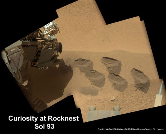
Curiosity scooped 5 times into Martian soil at Rocknest windblown ripple and delivered samples to the SAM chemistry instrument for analysis. This color mosaic was stitched together from hi-res color images taken by the robots 34 mm Mastcam camera on Sols 93 and 74. Credit: NASA / JPL-Caltech /MSSS/Ken Kremer (kenkremer.com)/Marco Di Lorenzo
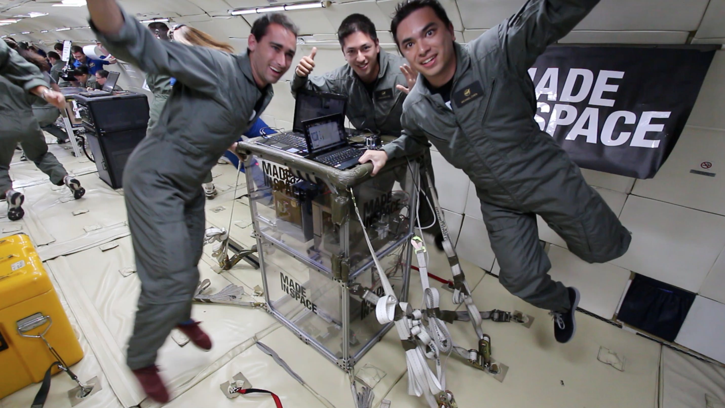
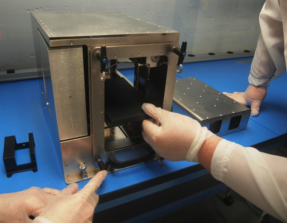
A test of the 3-D printer in a microgravity-like environment simulated on an airplane that flies parabolas. Credit: Made in Space
The joke about home renovation projects is it takes at least three trips to the hardware store to finish the work. In space, of course, spare parts are a lot harder to come by, meaning astronauts might have to wait for a spacecraft shipment, if, say, the toilet breaks. (Yes, this yucky situation has happened before.)
Some spare parts could be manufactured in space as early as next year, though, providing a 3-D printer passes all the preliminary steps. It recently got a big boost in that direction after passing its microgravity tests successfully, but there are still environmental tests to come, said the company that was behind the work.
“The 3-D printer we’re developing for the ISS is all about enabling astronauts today to be less dependent on Earth,” stated Noah Paul-Gin, the lead for the microgravity experiment.
“The version that will arrive on the ISS next year has the capability of building an estimated 30% of the spare parts on the station, as well as various objects such as specialty tools and experiment upgrades.”
A close-up of the 3-D printer prototype made by Made in Space. Credit: Made in Space
The firm tested the printer during four flights that, in part, simulated microgravity. They were on a specially designed airplane that flies parabolas, meaning it climbs and then briefly simulates, roller-coaster style, microgravity during the plunge before climbing again. (Each microgravity test is only about 30 seconds long.)
“The unique challenges posed by off-Earth 3-D printing require technology and hardware specifically adapted for space. In these microgravity tests, Made in Space assessed layer adhesion, resolution and part strength in the microgravity environment,” the company added.
After Made in Space received a contract for the 3D printer a couple of years ago, it flew three prototype versions that collectively were in microgravity 32 times.
If this printer makes it to space and performs well, it will add to the excitement of 3-D printing that has been swirling around the space community lately.
A study led by NASA recently investigated the possibility of using 3-D printing in association with creating robots to work on asteroids. Astronauts on the station could also have a food replicator of sorts on board the station, too, if a grant awarded to Systems & Materials Research Corperation this May pans out.
Three-image panorama of the Milky Way arching of the Badlands of South Dakota. Credit and copyright: Randy Halverson/Dakotalapse
We’ve oohed and ahhed many times over the handiwork of Randy Halverson and his Dakotalapse timelapse videos and imagery of the night sky. He may have outdone himself with his latest timelapse, called “Horizons.” Randy shot the footage from April – October 2012, mostly in South Dakota, but also some at Devils Tower in Wyoming.
“Growing up in South Dakota the landscape itself can be beautiful at times,” Randy says, “but that doesn’t compare to what the sky can do, especially at night.” Not only is the imagery absolutely breathtaking, but the accompanying music is an original called “I Forever” by Bear McCreary (The Walking Dead, Defiance, Battlestar Galactica, etc) his brother Brendan McCreary and his band Young Beautiful in a Hurry.
There’s a four-minute version below, but also available on Vimeo On Demand is a full 30-minute feature . Enjoy!!
The lead image and this one below are recent images from Randy that he has posted on Flickr.
Mirrored Aurora – Aurora mirrors off a small lake in central South Dakota on June 6, 2013. Credit and copyright: Randy Halverson/Dakotalapse.
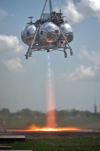
Morpheus during an April 2012 test. Credit: Joe Bibby
The above video should satisfy your daily need for rocket foom. Morpheus — a NASA testbed for vertical landing systems — did two firing tests this week that produced a fair amount of the usual fire and smoke, as you can see above.
You’ll actually see two separate firings in that video. In the first one, the lander strayed out of its safety zone and did a soft abort. The second test, NASA stated, “was a complete success.”
The first lander of the program crashed and burned in a test failure in August 2012, but officials recently praised the program for the progress it has made since then.
“Although a hardware failure led to the loss of the original vehicle last August, the failure and our internal investigation gave us valuable insight into areas that needed improvement,” a Project Morpheus blog post from May stated.
“The vehicle may look largely the same as the previous version, but there are numerous changes that have been incorporated. We have now implemented 70 different upgrades to the vehicle and ground systems to both address potential contributors to the test failure, and also to improve operability and maintainability.”
In the long run, NASA aims to use Morpheus as a “vertical test bed” for environmentally friendly propellants, as well as for automatic advances in landing and hazard detection.
The vehicle is advertised as big enough to land 1,100 pounds of cargo on the moon if it was placed nearby.
We love a good space debris mystery. Hey, who doesn’t, right? Regular readers of Universe Today know that it’s a shooting gallery out there, from meteor fireballs caught on dashboard cams to rogue space junk reentries lighting up our skies.
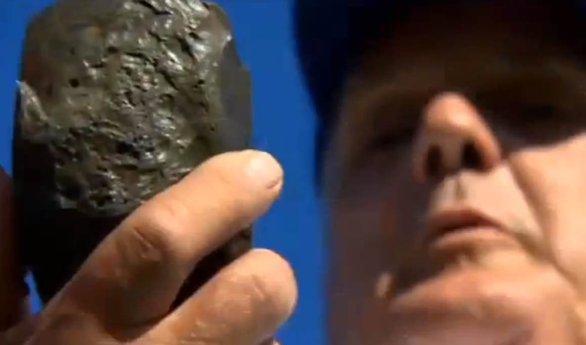
But an unusual story that made its rounds across the internet this past weekend caught our attention. What at first glance was a simple “Man finds space rock” story morphed into an extraordinary claim, which, in the words of the late great Carl Sagan, “demand extraordinary evidence.”
The find was made by Phil Green of Amesbury, Massachusetts. Mr. Green was searching the local riverbed for arrowheads when he came across the unusual find. The black pitted rock immediately struck him as something bizarre. It didn’t register as metallic to his metal detector, but Mr. Green kept it in his backyard for about five years until it was noticed by a friend.
“I didn’t really think much of it, and then a fellow came over, saw it and said that’s a meteor,” Green told local reporters.
From here, the story takes a strange turn. Green told local reporters that the rock was sent off for analysis, only to be returned to him just a few weeks ago. The analysis confirmed that the rock was indeed from space… sort of. It also stated that the vitreous material “shows a composition similar to that used in ballast by the Soviet space program starting in the mid-1980s.”
There are just a few problems with the tale. Mir reentered in 2001, six years before the 2007. A few articles do bother to note this, mentioning that Mir ended its career in the “so-called spacecraft cemetery of the southern Pacific Ocean,” about as far away from Massachusetts as you can get.
A few articles do also mention the possibility of a reentry of a Progress resupply vehicle being a potential source, or perhaps an unrelated Russian space vehicle.
But there seems to be a potential problem of the certification. Several articles state that the piece of debris coming from Mir was “confirmed by NASA.” However, Universe Today contacted NASA Chief Scientist for Orbital Debris Nicholas L. Johnson and NASA Headquarters official Joshua Buck, who both told us that no such NASA validation exists. Mr. Johnson went on to tell Universe Today that, “The NASA Orbital Debris Program Office has not been presented with any claim regarding debris from the Mir space station,” adding “I can tell you that it is not possible for debris from the Mir reentry to have landed in the U.S.”
A name that occasionally turns up in reports online as validating the find (withheld by request) also tells Universe Today that they had nothing to do with the discovery. Mr. Green or the original validation source have thus far been unavailable for comment.
We did uncover two documented reentries that occurred over the general region over the last few decades. One is the reentry of Mir-R 1986-017B (The rocket booster that launched the core module of Mir) seen from a trans-Atlantic airliner on February 24th 1986 about 500 kilometres off of the east coast of Newfoundland. Another possible suspect is the June 26/27th 2004 reentry of a SL-12 auxiliary rocket motor with the NORAD ID 1992-088E, seen to the west from New Jersey to Ontario.
Like the International Space Station, Mir was placed in a 51.6° inclined orbit. This made it accessible from the Baikonur Cosmodrome as well as visits from the U.S. Space Shuttle. Payloads going to and from the station would cover an identical ground track ranging from 51.6° north to south latitude.
The story is also reminiscent of the reentry of debris from Sputnik 4, which struck a small town in Wisconsin in 1962. This was analyzed by mineralogist Ursula Marvin and confirmed to be of Russian origin.
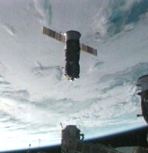
A Progress spacecraft inbound for docking with the International Space Station. (Credit: NASA).
Probably the biggest question in our minds is: what links the object back to an errant Russian spacecraft? What do they use for ballast, anyhow? How did they arrive at the often quoted “85% certainty?” of the object’s origin?
Still, the find does look like something interesting. The pitting and the melted fusion crust are all reminiscent of reentry. We’ll keep researching this story, and for the time being we’ll leave it up to you, the diligent and insightful readers of Universe Today, to make up your own minds on this strange and interesting tale.
Mosaic of Saturn seen in eclipse in September 2006. Earth is the bright dot just inside the F ring at upper left. (CICLOPS/NASA/JPL-Caltech/SSI)
Citizens of Earth, get ready for your Cassini close-up: once again the spacecraft is preparing to capture images of Saturn positioned between it and the Sun, allowing for incredible views of the ring system and its atmosphere — and also a tiny “pale blue dot” in the distance we call home.
Earth seen from Cassini (NASA/JPL/SSI)
The mosaic above was composed of images captured during such an eclipse event in September 2006, and quickly became an astronomical sensation. It’s not often we get an idea of what we look like from so far away, and seeing our entire world represented as a small speck of light nestled between Saturn’s rings is, to me anyway, both impressive and humbling.
Humbling because of how small we look, but impressive because as a species we have found a way to do it.
And next month, on Friday, July 19 between 21:27 and 21:42 UTC (5:27 – 5:42 p.m. EDT) Cassini will do it again.
“Ever since we caught sight of the Earth among the rings of Saturn in September 2006 in a mosaic that has become one of Cassini’s most beloved images, I have wanted to do it all over again, only better,” said Cassini imaging team leader, Carolyn Porco. “And this time, I wanted to turn the entire event into an opportunity for everyone around the globe, at the same time, to savor the uniqueness of our beautiful blue-ocean planet and the preciousness of the life on it.”
Porco was involved in co-initiating and executing the famous “Pale Blue Dot” image of Earth taken by NASA’s Voyager 1 from beyond the orbit of Neptune in 1990.
“It will be a day for all the world to celebrate,” she said.
The intent for the upcoming mosaic is to capture the whole scene, Earth and Saturn’s rings from one end to the other, in Cassini’s red, green and blue filters that can be composited to form a natural color view of what our eyes might see at Saturn. Earth and the Moon will also be imaged with a high resolution camera — something not yet done by Cassini.
We can all consider ourselves pretty lucky, too… this is the first time in history that we humans will know in advance that our picture is going to be taken from nearly a billion miles away.
“While Earth will be only about a pixel in size from Cassini’s vantage point 898 million miles [1.44 billion kilometers] away, the Cassini team is looking forward to giving the world a chance to see what their home looks like from Saturn,” said Linda Spilker, Cassini project scientist at NASA’s Jet Propulsion Laboratory. “With this advance notice, we hope you’ll join us in waving at Saturn from Earth, so we can commemorate this special opportunity.”
So on July 19, remember to look up and wave… Cassini will be watching!
Read more on the CICLOPS news release here and on the NASA/JPL Cassini mission site here.
“That’s here. That’s home. That’s us. On it everyone you love, everyone you know, everyone you ever heard of, every human being who ever was, lived out their lives… There is perhaps no better demonstration of the folly of human conceits than this distant image of our tiny world.”


