Spacesuited Astronauts Climb Aboard Boeing CST-100 Commercial Crew Capsule for Key Tests

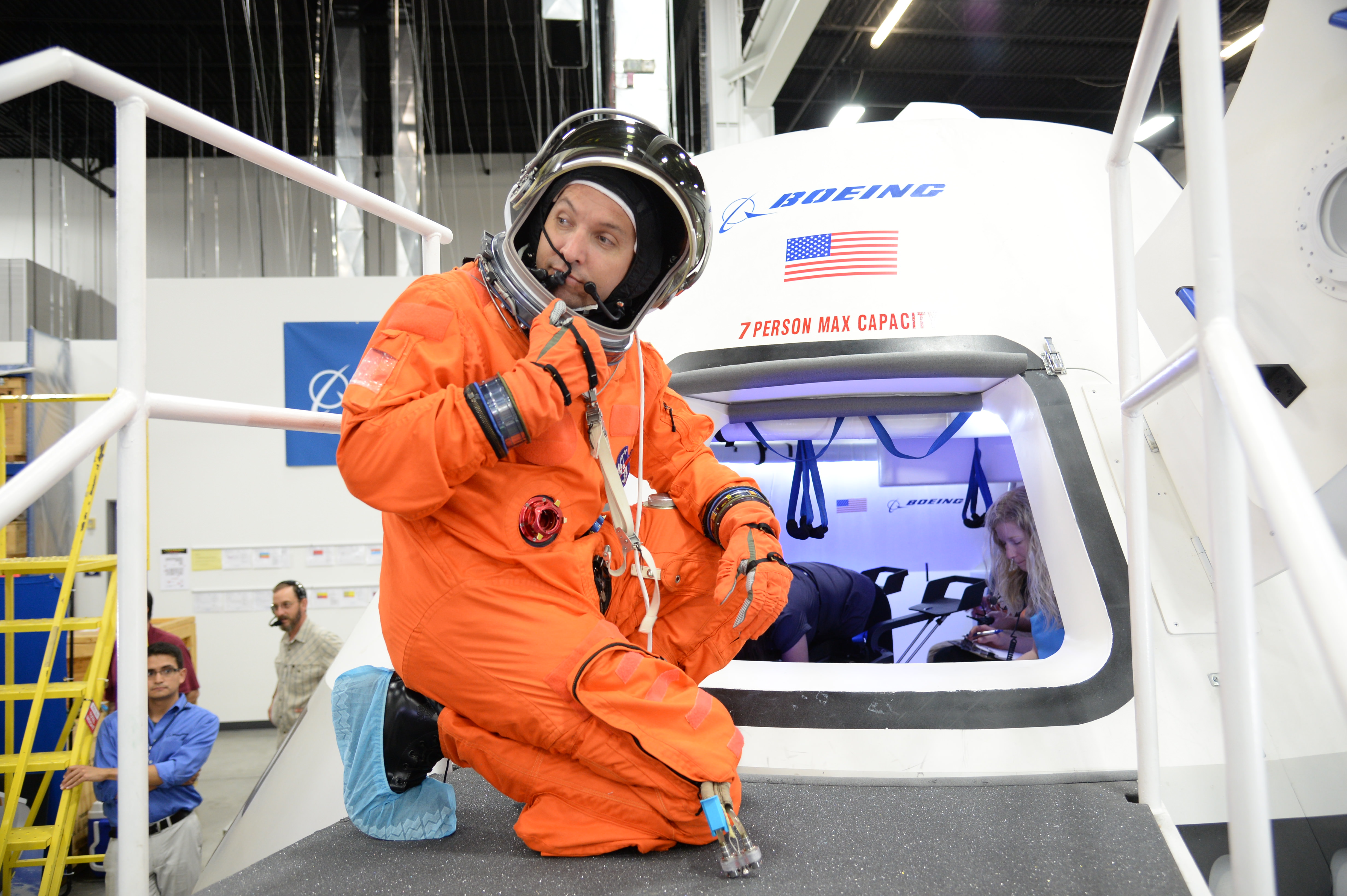
NASA astronaut Randy Bresnik prepares to enter the CST-100 spacecraft, which was built inside The Boeing Company's Houston Product Support Center. Credit: NASA/Robert Markowitz

A pair of NASA astronauts donned their spacesuits for key fit check evaluations inside a test version of the Boeing Company’s CST-100 commercial ‘space taxi’ which was unveiled this week for the world’s first glimpse of the cabin’s interior.

Boeing is among a trio of American aerospace firms, including SpaceX and Sierra Nevada Corp, seeking to restore America’s capability to fly humans to Earth orbit and the space station using seed money from NASA’s Commercial Crew Program (CCP).

Astronauts Serena Aunon and Randy Bresnik conducted a day long series of technical evaluations inside a fully outfitted, full scale mock up of the CST-100, while wearing NASA’s iconic orange launch-and-entry flight suits from the space shuttle era.

During the tests, Boeing technicians monitored the astronauts ergonomic ability to work in the seats and move around during hands on use of the capsules equipment, display consoles and storage compartments.

The purpose of the testing at Boeing’s Houston Product Support Center is to see what works well and what needs modifications before fixing the final capsule design for construction.

“It’s an upgrade,” said astronaut Serena Aunon at the evaluation. “It is an American vehicle, of course it is an upgrade.”
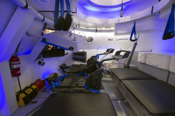
This is an interior view of The Boeing Company's CST-100 spacecraft, which features LED lighting and tablet technology.  Image Credit: NASA/Robert Markowitz
This is an interior view of The Boeing Company’s CST-100 spacecraft, which features LED lighting and tablet technology.
Image Credit: NASA/Robert Markowitz

Former NASA Astronaut Chris Ferguson, the commander of the final shuttle flight (STS-135) by Atlantis, is leading Boeing’s test effort as the director of Boeing’s Crew and Mission Operations.

“These are our customers. They’re the ones who will take our spacecraft into flight, and if we’re not building it the way they want it we’re doing something wrong,” said Ferguson.

“We’ll probably make one more go-around and make sure that everything is just the way they like it.”

The CST-100 is designed to carry a crew of up to 7 astronauts, or a mix of cargo and crew, on missions to low-Earth orbit (LEO) and the International Space Station (ISS) around the middle of this decade.

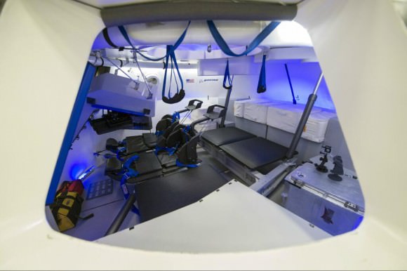
Although it resembles Boeing’s Apollo-era capsules from the outside, the interior employs state of the art modern technology including sky blue LED lighting and tablet technology.

Check out this video showing the astronauts and engineers during the CST-100 testing

Nevertheless Boeing’s design goal is to keep the flight technology as simple as possible.

“What you’re not going to find is 1,100 or 1,600 switches,” said Ferguson. “When these guys go up in this, they’re primary mission is not to fly this spacecraft, they’re primary mission is to go to the space station for six months. So we don’t want to burden them with an inordinate amount of training to fly this vehicle. We want it to be intuitive.”

The CST-100 crew transporter will fly to orbit atop the venerable Atlas V rocket built by United Launch Alliance (ULA) from Launch Complex 41 on Cape Canaveral Air Force Station in Florida.
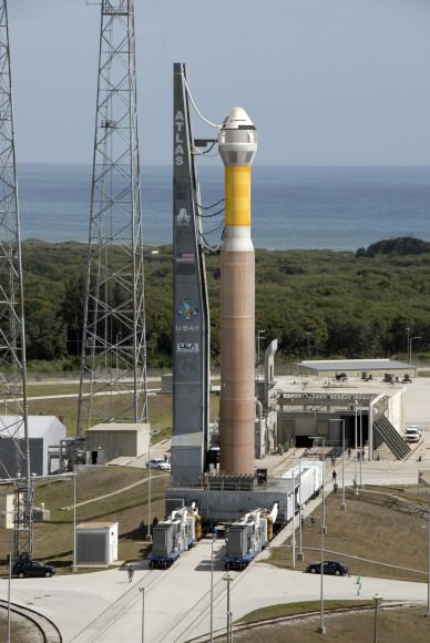
The CST-100 crew capsule awaits liftoff aboard an Atlas V launch vehicle at Cape Canaveral in this artist’s concept. Credit: Boeing

Boeing is aiming for an initial three day manned orbital test flight of the CST-100 during 2016, says John Mulholland, Boeing vice president and program manger for Commercial Programs.

The 1st docking mission to the ISS would follow in 2017 – depending on the very uncertain funding that Congress approves for NASA.

The Atlas V was also chosen to launch one of Boeing’s commercial crew competitors, namely the Dream Chaser mini shuttle built by Sierra Nevada Corp.
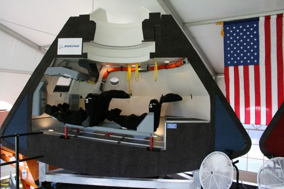
Boeing CST-100 capsule mock-up, interior view. Credit: Ken Kremer – kenkremer.com
Boeing CST-100 capsule early mock-up, interior view. Credit: Ken Kremer – kenkremer.com

NASA’s CCP program is fostering the development of the CST-100 as well as the SpaceX Dragon and Sierra Nevada Dream Chaser to replace America’s capability to launch humans to space that was lost following the retirement of NASA’s space shuttle orbiters two years ago in July 2011.

Since 2011, every American astronaut has been 100% dependent on the Russians and their Soyuz capsule to hitch a ride to the ISS.

“We pay one of our [ISS] partners, the Russians, $71 million a seat to fly,” says Ed Mango, CCP’s program manager. “What we want to do is give that to an American company to fly our crews into space.”

Simultaneously NASA and its industry partners are designing and building the Orion crew capsule and SLS heavy lift booster to send humans to the Moon and deep space destinations including Near Earth Asteroids and Mars.
Ken Kremer

Interior view of Boeing CST-100 commercial crew capsule. Credit: NASA

Timelapse: Super Moon Rising Over the Rocky Mountians

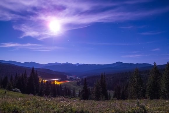
A series of photos combined to show the rise of the July 22, 2013 ‘super’ full moon over the Rocky Mountains, shot near Vail, Colorado, at 10,000ft above sea level in the White River National Forest. Moon images are approximately 200 seconds apart. Credit and copyright: Cory Schmitz

Astrophotographer Cory Schmitz braved a brown bear in order to capture some wonderful images of the full Moon rise on July 22, 2013. This composite shows a series of images of the moonrise, and below is a beautiful timelapse.

This perigee Moon, a.k.a “Super Moon” was the third and final of the big full Moons for 2013. However, as astrophysicist Neil DeGrasse Tyson mentioned on Twitter, it is “Okay to call tonight’s Full Moon “super” but only if you would call a 13-inch pizza “super” compared with a 12-inch pizza.”

You can catch more of Cory with Fraser on the Virtual Star Parties on Sunday nights. Below are a couple of more great scenes from Cory’s full Moon experience:

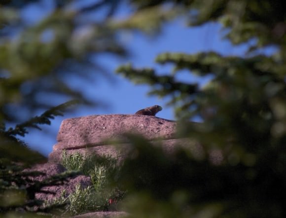
A bear sits right on the spot where Cory Schmitz wanted to set up his photography equipment. Image courtesy Cory Schmitz.
The full-moon illuminated landcape, overlooking Interstate 70, near Vail, Colorado. Credit and copyright: Cory Schmitz.

How Can We Stop An Asteroid?

“It’s like looking for a charcoal briquette in the dark,” says Bill Nye the Science Guy in this new video from AsapSCIENCE… except he’s talking about briquettes hundreds of meters wide whizzing past our planet upwards of 8, 9, 10, even 20 kilometers per second — and much, much denser than charcoal.

Near-Earth asteroids are out there (and on occasion they even come in here) and, as the planet’s only technologically advanced spacefaring species, you could say the onus is on us to prevent a major asteroid impact from occurring, if at all possible — whether to avoid damage in a populated area or the next mass extinction event. But how can we even find all these sooty space rocks and, once we do, what can be done to stop any headed our way?

Watch the video (and then when you’re done, go visit the B612 Foundation’s Sentinel page to learn more about an upcoming mission to bag some of those space briquettes.)

Kepler Team Has Some Success in Reaction Wheel Recovery Attempt

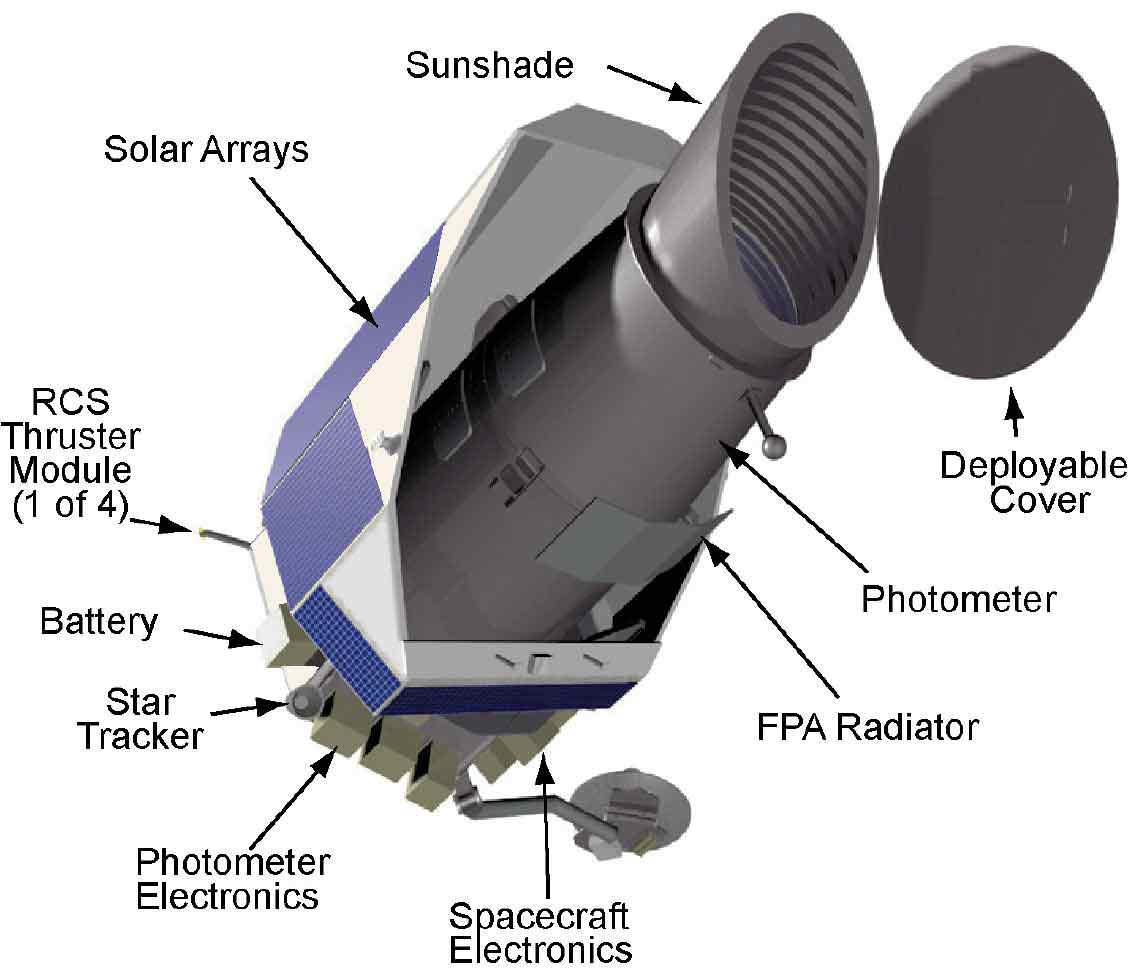
A diagram of the Kepler space telescope. Credit: NASA

In May of this year, the Kepler planet-hunting telescope lost its ability to precisely point toward stars, putting its exoplanet search in jeopardy. Two of the four reaction wheels failed, and Kepler scientists say the spacecraft needs at least three reaction wheels to be able to point precisely enough to continue the mission. In the latest update from Kepler, mission manager Roger Hunter says that the team has made a little headway and had initial success in testing the two failed reaction wheels. But the big test will come later to see how much friction the two wheels generate with continued use.

On Thursday, July 18, 2013 the team initiated recovery tests on the spacecraft’s two failed wheels in order to characterize how the two wheels (Reaction Wheels (RW) 4 and 2) operated and to determine if either could be returned to full use.

RW4 did not spin in the positive (or clockwise) direction but the wheel did spin in the negative (or counterclockwise) direction. Wheel 4 is thought to be the more seriously damaged of the two, Hunter said.

Then, on Monday, July 22 the team tested RW2, and that wheel responded positively to test commands and spun in both directions.

“Over the next two weeks, engineers will review the data from these tests and consider what steps to take next,” Hunter said. “Although both wheels have shown motion, the friction levels will be critical in future considerations. The details of the wheel friction are under analysis.”

Too much friction from the reaction wheels can cause vibration and impact the pointing precision of the telescope.

Kepler has found over 2,700 planetary candidates, with 130 confirmed planets, from the size of Earth’s moon to larger than Jupiter. There are two years of data that has yet to be combed through to detect the faint periodic dimming of distant starlight – the telltale sign of a planet transiting the face of its host star.

Still, the loss of Kepler would be a blow to the search for planets orbiting other stars. Earlier this year, Kepler team members said if the spacecraft could no longer do planet-hunting, there’s a chance it could do something else , such as asteroid hunting or other astronomical observations…just something that doesn’t need as precise ability for pointing.

Source: Kepler Mission Manager Update

Pretty Picture from Space: Thunderstorms Over Southern California

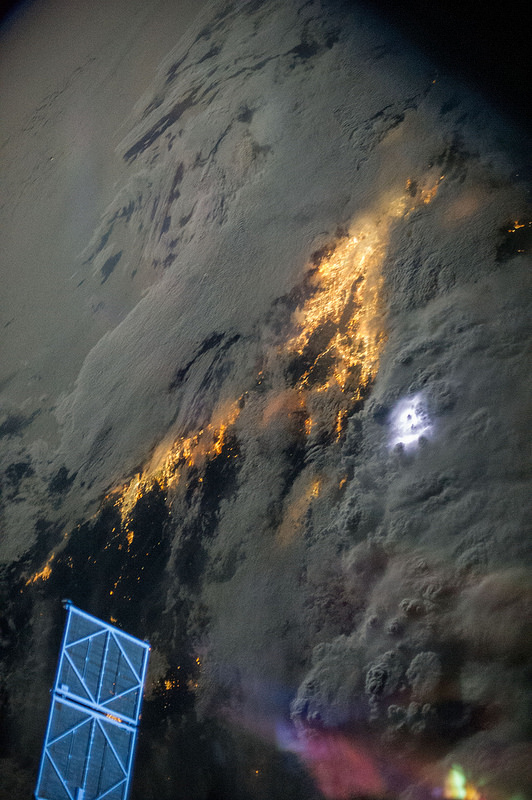
Early morning lightning storms, inland of LA and San Diego, on July 21, 2013, as seen from the International Space Station. Credit: NASA

Astronaut Karen Nyberg shared this image on her Twitter feed, showing the view from the International Space Station on July 21, 2013 with thunderstorms brewing over Los Angeles and San Diego, California. City lights are peering through the clouds, while lightning brightens the dark storm clouds. A solar array from a Russian spacecraft docked to the ISS appears at the bottom of the image.

Incredible view.

Russian Meteorite Bits Will Be Used In Some 2014 Olympic Medals

The two main smoke trails left by the Russian meteorite as it passed over the city of Chelyabinsk. Credit: AP Photo/Chelyabinsk.ru

Going for gold in the Sochi Winter Olympics could earn athletes some out-of-this-world rocks.

Athletes who top the podium on Feb. 15, 2014 will receive special medals with pieces of the Chelyabinsk meteor that broke up over the remote Russian community on that day in 2013, according to media reports.

“We will hand out our medals to all the athletes who will win gold on that day, because both the meteorite strike and the Olympic Games are the global events,” stated Chelyabinsk Region Culture Minister Alexei Betekhtin in a Ria Novosti report.

The reported sports that will receive these medals include:

  • Women’s 1,000 meter and men’s 1,500 meter short track;
  • Men’s skeleton;
  • Women’s cross-country skiing relay;
  • Men’s K-125 ski jump;
  • Men’s 1,500 meter speed skating;
  • Women’s super giant slalom.

The 55-foot (17-meter) meteor’s airburst in February damaged buildings, causing injuries and fright among those in the region. As astronomers have been collecting fragments and calculating the orbit of the fireball, the incident put renewed attention on the need to monitor space rocks that could threaten the Earth.

Check out this Universe Today collection of videos showing what the meteor looked like.

Podcast: Creating a Scienc-y Society

Our modern society depends on science. It impacts the way we eat, work, communicate and play. And yet, most people take our amazing scientific advancement for granted, and some are even hostile to it. What can we do to spread the love of science through education, outreach and media?

Click here to download the episode.

Or subscribe to: astronomycast.com/podcast.xml with your podcatching software.

“Creating a Scienc-y Society” on the Astronomy Cast website, with shownotes and transcript.

And the podcast is also available as a video, as Fraser and Pamela now record Astronomy Cast as part of a Google+ Hangout (usually recorded every Monday at 3 pm Eastern Time):

HiRISE Camera Spots Curiosity Rover (and tracks) on Mars

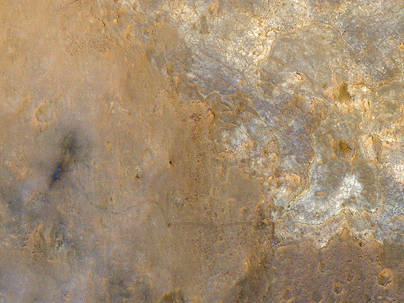
The view from the Mars Reconnaissance Orbiter's HiRISE camera showing the Curiosity Rover at the 'Shaler' outcrop in Gale Crater. Credit: NASA/JPL-Caltech/Univ. of Arizona.

I spy the Curiosity Rover! With the Sun over its shoulders, the High Resolution Imaging Science Experiment (HiRISE) camera on the Mars Reconnaissance Orbiter snapped this image of the Curiosity rover on June 27, 2013, when Curiosity was at an outcrop called “Shaler” in the “Glenelg” area of Gale Crater. The rover appears as a bluish dot near the lower right corner of this enhanced-color image, and also visible are the rover’s tracks.

“The rover tracks stand out clearly in this view,” wrote HiRISE principal investigator Alfred McEwen on the HiRISE website, “extending west to the landing site where two bright, relatively blue spots indicate where MSL’s landing jets cleared off the redder surface dust.”

McEwen explained how MRO was maneuvered to provide unique lighting, where the Sun was almost directly behind the camera, so that the Sun, MRO, and MSL on the surface were all aligned in nearly a straight line.

When HiRISE captured this view, the Mars Reconnaissance Orbiter was rolled for an eastward-looking angle rather than straight downward. The afternoon sun illuminated the scene from the western sky, so the lighting was nearly behind the camera. Specifically, the angle from sun to orbiter to rover was just 5.47 degrees.

McEwen said this geometry hides shadows and better reveals subtle color variations. “With enhanced colors, we can view the region around the landing site and Yellowknife Bay,” he said.

For scale, the two parallel lines of the wheel tracks are about 10 feet (3 meters) apart.

Curiosity has now moved on, and is now heading towards the large mound in Gale Crater (with long drives!) officially named Aeolis Mons (also called Mount Sharp.)

Submissions Needed for Saturn Mosaic Project

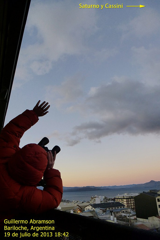
Guillermo Abramson from Argentina takes a picture of himself waving at Saturn on July 19, 2013 during 'The Day the Earth Smiled' event. Credit and copyright: Guillermo Abramson.

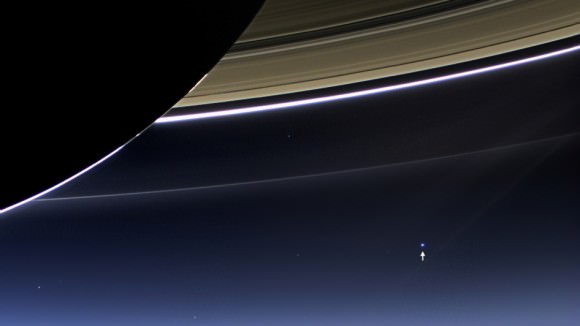
For all our astrophotographer friends out there: If you haven’t heard about the Saturn Mosaic Project, you’ll want to take note of this. In cooperation with Astronomers Without Borders, the special project for the recent Cassini image of planet Earth, called The Day The Earth Smiled (TDTES) is sponsoring a Saturn Mosaic project, where you can submit an image you’ve taken of Saturn. Those received will be compiled into a mosaic that will look like image that Cassini took on July 19, showing Earth just below Saturn’s rings (see below). But when you zoom in you’ll see all the pictures from Earth that the mosaic is made of.

I received a note from AWB President Mike Simmons saying they need more submissions, and the deadline for submitting a photo has been extended to July 29, 2013.

“I know a lot more people will want to be a part of this if they know about it,” Mike said via email. “It’s something to tide everyone over and keep the buzz going while we wait for the final mosaic from Cassini.”

But you don’t have to be a seasoned astrophotographer to take part in the Saturn Mosaic. The image you submit doesn’t have to be one taken with a large telescope – just take a picture of Saturn as a “star” in the sky with an ordinary camera, capturing your surroundings as well. Or it could be an image you took earlier this year.

“There are other kinds of photos that anyone can submit that don’t even requiring imaging the sky,” Simmons added. “We didn’t want to limit this to only those with the ability and weather to image Saturn itself.  Photos of outreach events or people waving at Saturn from JPL’s Wave at Saturn are good, too.  Or just a portrait taken with the Lord of the Rings — a live view projected from a telescope or even a photo.  Like a couple getting married at the time Cassini was taking their photo (and everyone else’s) posed with Saturn.  I took the easy way and took a shot of me and Saturn in my office.”

These can be taken any time, so people can still take a shot and get into the mosaic (the image does need to have been taken in 2013, however.)

“It’s all about sharing and commemorating the excitement of the moment when the photo was taken, and the anticipation of the release of Cassini’s historic photos,” Simmons said.  “Like all Astronomers Without Borders project, it’s open to everyone on Earth.  And beyond.”

For a slide show of some of the great shots people have submitted so far, visit the Saturn Mosaic Project page to see things like Saturn with a T-Rex, outreach in Iran, kids drawings of Saturn in Ghana, and more.

Simmons said The World at Night will create the final mosaic, which is expected to be online and ready to view and zoom in on by August 4 or earlier.

So take your best shot and be a part of the mosaic! Find out more on the Astronomers Without Borders website.

The Day the Earth Smiled: Sneak Preview. In this rare image taken on July 19, 2013, the wide-angle camera on NASA's Cassini spacecraft has captured Saturn's rings and our planet Earth and its moon in the same frame. Image Credit: NASA/JPL-Caltech/Space Science Institute
The Day the Earth Smiled: Sneak Preview. In this rare image taken on July 19, 2013, the wide-angle camera on NASA’s Cassini spacecraft has captured Saturn’s rings and our planet Earth and its moon in the same frame. Image Credit: NASA/JPL-Caltech/Space Science Institute

Curiosity Sets Record Pace for Longest Drive Yet on Mars

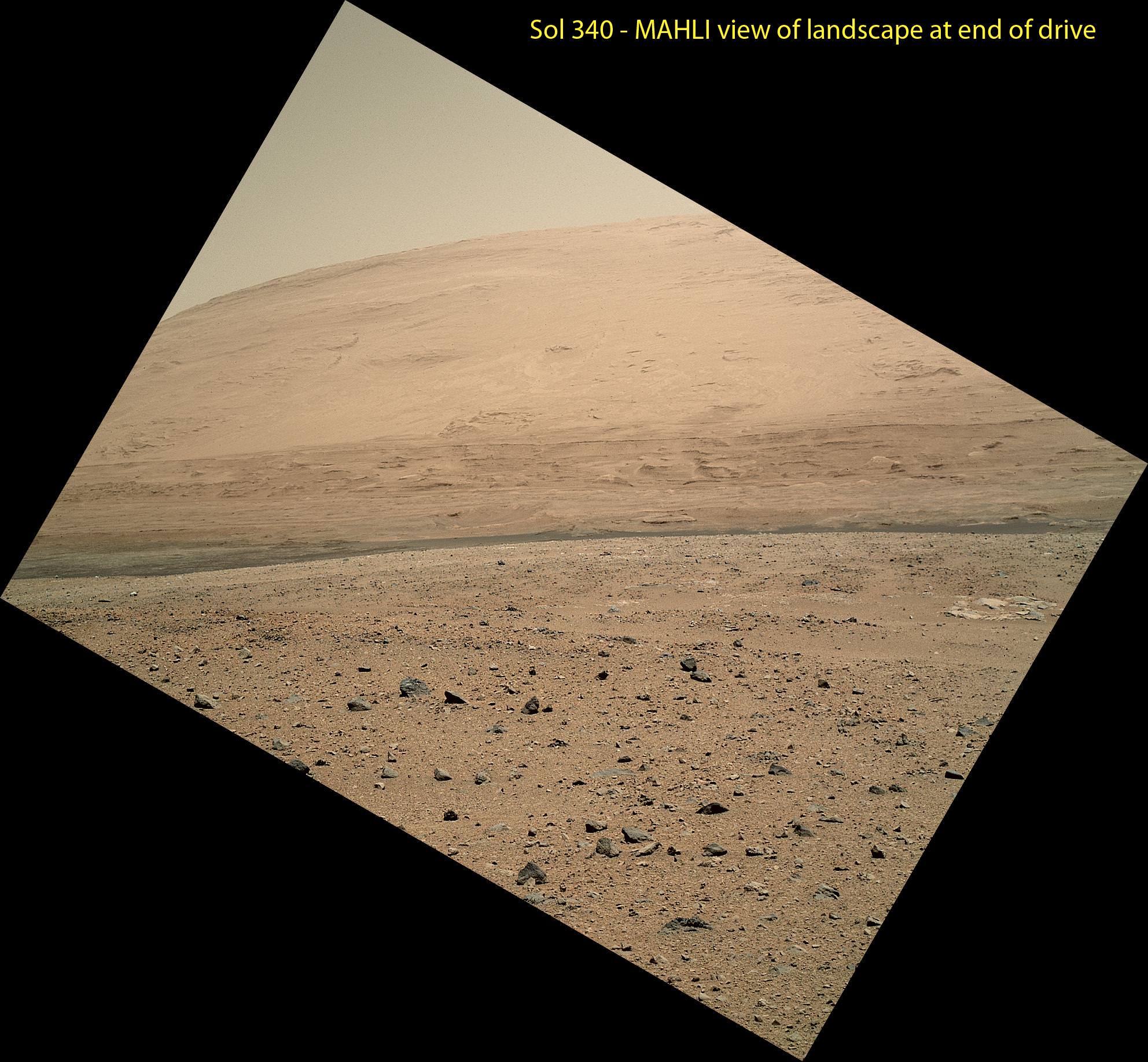
The scene taken on Sol 340 was taken shortly after Curiosity finished her longest yet. The 329.1-foot (100.3-meter) drive was twice as long as any previous sol's drive by Curiosity. The view is toward the south, including a portion of Mount Sharp and a band of dark dunes in front of the mountain. The Mars Hand Lens Imager (MAHLI) camera on NASA's Curiosity rover is carried at an angle when the rover's arm is stowed for driving. Still, the camera is able to record views of the terrain Curiosity is crossing in Gale Crater, and rotating the image 150 degrees provides this right-side-up scene. Credit: NASA/JPL-Caltech/MSSS

This scene was taken on Sol 340 shortly after Curiosity finished her longest drive yet
The 329.1-foot (100.3-meter) drive was twice as long as any previous sol’s drive by Curiosity. The view is toward the south, including a portion of Mount Sharp and a band of dark dunes in front of the mountain. The Mars Hand Lens Imager (MAHLI) camera on NASA’s Curiosity rover is carried at an angle when the rover’s arm is stowed for driving. Still, the camera is able to record views of the terrain Curiosity is crossing in Gale Crater, and rotating the image 150 degrees provides this right-side-up scene. Credit: NASA/JPL-Caltech/MSSS
See updated Traverse Map below[/caption]

NASA’s car-sized Curiosity rover is now blazing across the Red Planet’s surface and moving at a record setting pace towards a towering Martian mountain loaded with mineral caches that could potentially support a habitable environment.

On Sunday, July 21 (or Sol 340), Curiosity drove the length of a football field – 109.7 yards (100.3 meters) – a span that’s twice as far as she had ever driven before since the dramatic touch down on Mars nearly a year ago.

The previous record for a one-day drive was about half a football field – 54 yards (49 meters) – and achieved on Sol 50 (Sept. 26, 2012), roughly seven weeks after the pulse pounding landing inside Gale Crater on Aug. 6, 2012.

The 6 wheeled robot was able to move so far because on the prior drive she wound up atop a rise offering an uncommonly good view of the surrounding landscape and the road ahead across the crater floor towards Mount Sharp – the ultimate driving goal.

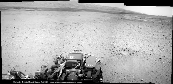
Curiosity On the Road to Mount Sharp and treacherous Sand Dunes - Sol 338 - July 19.  Curiosity captured this panoramic view of the path ahead to the base of Mount Sharp and potentially dangerous sand dunes after her most recent drive on July 19, 2013. She must safely cross over the dark dune field to climb and reach the lower sedimentary layers of Mount Sharp.   Credit: NASA/JPL-Caltech/Ken Kremer-(kenkremer.com)/Marco Di Lorenzo
Curiosity On the Road to Mount Sharp and treacherous Sand Dunes – Sol 338 – July 19
Curiosity captured this panoramic view of the path ahead to the base of Mount Sharp and potentially dangerous sand dunes after a recent drive on July 19, 2013. She must safely cross over the dark dune field to climb and reach the lower sedimentary layers of Mount Sharp.
Credit: NASA/JPL-Caltech/Ken Kremer-(kenkremer.com)/Marco Di Lorenzo

“What enabled us to drive so far on Sol 340 was starting at a high point and also having Mastcam images giving us the size of rocks so we could be sure they were not hazards,” said rover planner Paolo Bellutta of NASA’s Jet Propulsion Laboratory, Pasadena, Calif, in a NASA statement.

“We could see for quite a distance, but there was an area straight ahead that was not clearly visible, so we had to find a path around that area.”

Following another lengthy drive of 68.2 yards (62.4 meters) on Wednesday, July 23 (Sol 342), the mission’s total driving distance so far stands at 0.81 mile (1.23 kilometers).

Mount Sharp lies about 5 miles (8 kilometers) distant – as the Martian crow flies.

On July 4, Curiosity embarked on the epic trek to Mount Sharp after completing more than seven months of science investigations and historic interplanetary drilling and sample analysis at an area known as Glenelg and Yellowknife Bay. There she discovered a habitable environment with the chemical ingredients that could sustain Martian microbes- thereby already accomplishing the primary goal of NASA’s flagship mission to Mars.

A combination of increased experience by the engineers directing the mega rover as well as intermediate software upgrades also play key roles in speeding Curiosity towards 3.4 mile (5.5 km) high Mount Sharp.

A huge leap in roving across Mars is in the works soon using new driving software called autonomous navigation, or autonav, that will hasten the overland journey.

“We have put some new software – called autonav, or autonomous navigation – on the vehicle right after the conjunction period back in March 2013,” said Jim Erickson, Curiosity Project Manager, in exclusive interview with Universe Today. Erickson is from NASA’s Jet Propulsion Laboratory (JPL) in Pasadena, Calif.

“This will increase our ability to drive.”

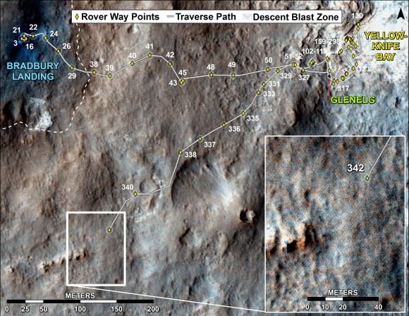
Curiosity's Traverse Map Through Sol 342. This map shows the route driven by NASA's Mars rover Curiosity through the 342 Martian day, or sol, of the rover's mission on Mars (July 21, 2013). Numbering of the dots along the line indicate the sol number of each drive. North is up. The scale bar is 200 meters (656 feet). From Sol 340 to Sol 342, Curiosity had driven a straight line distance of about 191.9 feet (58.49 meters).  The base image from the map is from the High Resolution Imaging Science Experiment Camera (HiRISE) in NASA's Mars Reconnaissance Orbiter.   Image Credit: NASA/JPL-Caltech/Univ. of Arizona
Curiosity’s Traverse Map Through Sol 342
This map shows the route driven by NASA’s Mars rover Curiosity through the 342 Martian day, or sol, of the rover’s mission on Mars (July 21, 2013). Numbering of the dots along the line indicate the sol number of each drive. North is up. The scale bar is 200 meters (656 feet). From Sol 340 to Sol 342, Curiosity had driven a straight line distance of about 191.9 feet (58.49 meters). The base image from the map is from the High Resolution Imaging Science Experiment Camera (HiRISE) in NASA’s Mars Reconnaissance Orbiter.
Image Credit: NASA/JPL-Caltech/Univ. of Arizona

Implementing the new driving software will make Curiosity smarter as well as more capable, productive and independent than ever before.

“With autonav the rover will have the ability to understand how far it’s driving, whether its slipping or not, and it improves safety,” Erickson told me.

The rover’s route is on a southwestward heading towards the ancient sedimentary layers at the foothills of the mountain in the middle of Gale Crater.

In addition to setting new driving records, the 1 ton rover is also driving more frequently and on repeated days too.

When everything synchs up, Curiosity can drive two or more days in row.

“We can drive two days in a row now if the timing is right. If we get the results of the day’s drive (n) in time before we have to plan the next day’s drive (n+1) – almost as if you’re on Mars time. Then that would work fine,” Erickson explained.

“Also, when we get the autonav capability we can plan two days in row. One day of directed driving and the second day can be ‘OK here’s your target from wherever you end up, try and go to this spot’.”

“This will increase the productivity!”

Erickson says the team is testing autonav now and should it be up and running within weeks, or sooner.

Read Part 1 & Part 2 of my interview with Jim Erickson for further details.

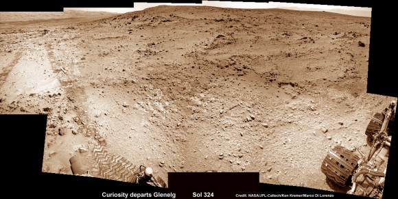
This photomosic shows NASA’s Curiosity departing at last for Mount Sharp- her main science destination. Note the wheel tracks on the Red Planet’s surface. The navcam camera images were taken on July 4, 2013 (Sol 324). Credit: NASA/JPL-Caltech/Ken Kremer (kenkremer.com)/Marco Di Lorenzo

Meanwhile Curiosity’s older sister rover Opportunity is making fast tracks towards her own mountain goal and should arrive at the base of Solander Point rather soon in August.

Solander Point is a segment of the eroded rim of huge Endeavour crater and may also possess key ingredients essential to support an environment favorable for possible Martian microbes.

And it’s worth noting that older sis Opportunity stills holds the 1 day Martian distance driving world record of 219.89 meters – established more than 8 years ago on Sol 410 (March 20, 2005)!!

Stay tuned for more on NASA’s sojourning pair of Martian robots.

Ken Kremer