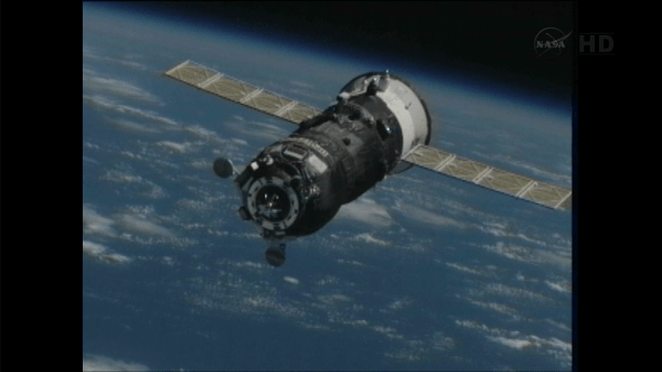
Progress 50 approaching the International Space Station on Feb. 11, 2013. Via NASA TV.
The Progress 50 resupply ship has now arrived at the International Space Station, just hours after it launched from the Baikonur Cosmodrome in Kazakhstan. Launch took place at 9:41 a.m. EST, (14:40 UTC) today (February 11, 2013) and it took only a four-orbit journey to rendezvous with the ISS, docking at 3:34 pm EST (20:35 UTC).
“Progress 50 just docked to our Space Station!” Tweeted astronaut Chris Hadfield (@Cmdr_Hadfield) “I was right at the hatch, it made a quick sliding scraping noise & then a solid thud. Success!”
This is third successful execution of the new, modified launch and docking profile for the Russion Progress ships, and its success is paving the way for its first use on a manned mission – possibly as early as March 2013 for Soyuz TMA-08, Roscosmos said via Facebook. Russian cosmonaut Gennady Padalka has been quoted as saying it is every cosmonaut’s dream to only have a 6-hour flight in the cramped Soyuz.
Watch the launch and docking video below:
Normally, Progress supply ships –and manned Soyuz capsules — are launched on trajectories that require about two days, or 34 orbits, to reach the ISS. The new fast-track trajectory has the rocket launching shortly after the ISS passes overhead — today, the space station was just 1,400 kilometers (870 miles) downrange from the launch site at the time of liftoff. Then additional firings of the Progress engines early in its mission expedites the time required for a Russian vehicle to reach the complex.
That also give the ISS crew the chance to actually see the launch from orbit. Today, NASA-TV commentator Kyle Herring said that ISS commander Kevin Ford reported he was able to see the first stage separation, which occurred about two minutes after launch. Herring said the cameras on the International Space Station were pointed to try and observe the launch. We’ll add any images here, if the cameras were able to capture anything.
Progress 50 is carrying 2.9 tons of supplies and equipment, including 800 kg (1,764 pounds) of space station propellant, 50 kg (110 lbs)of oxygen and air, 420 kg (926lbs) of water and 1,360 kg (3,000 lbs) of spare parts, science gear and other dry cargo. Right now, this Progress is scheduled to remain docked at the ISS until late April. The previous Progress cargo ship undocked from the Pirs module of the International Space Station at 13:15 GMT on Saturday February 9 and re-entered Earth’s atmosphere over the Pacific Ocean, burning up during re-entry.
Earlier this month, NASA’s Space Station Program Manager Mike Suffradini said the space station partners have tentatively agreed to try a the fast-track trajectory with a manned mission “at least once or twice to show we have the capability in case we need to get to ISS quick for any reason.”
He added that the decision to fly like this long-term is still to be determined.
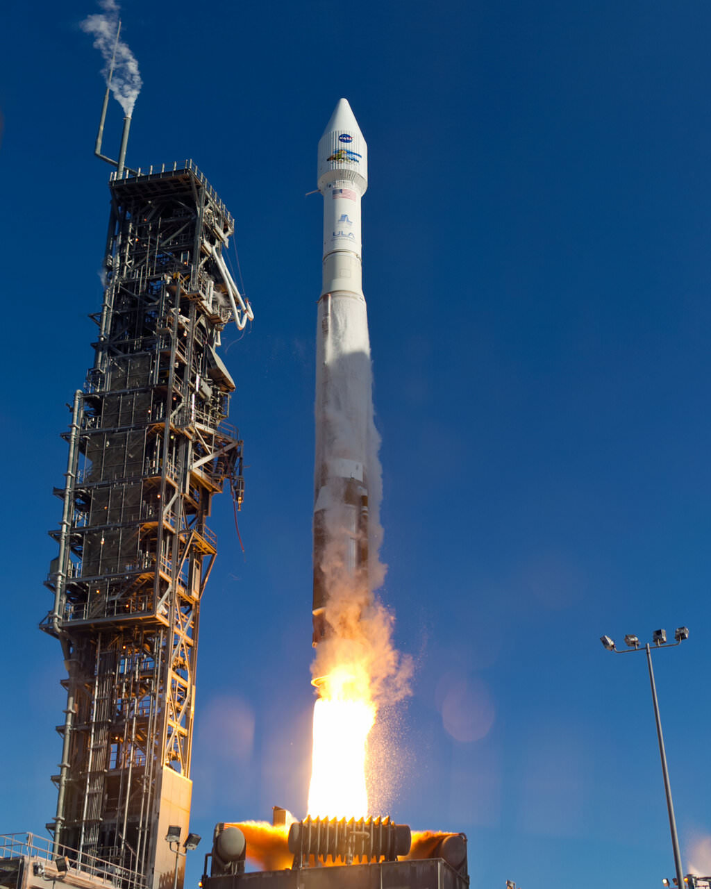
An Atlas-V rocket with the Landsat Data Continuity Mission (LDCM) spacecraft onboard is seen as it launches on Monday, Feb. 11, 2013 at Vandenberg Air Force Base, California. Credit: NASA
NASA launched a successor to the long-time Landsat satellite Earth-observing program today, sending the Landsat Data Continuity Mission satellite to orbit via an Atlas V rocket from Vandenberg Air Force Base at 1:02 EST (10:02 PST, 18:02 UTC). The new LDCM carries two new instruments, the Operational Land Imager and the Thermal Infrared Sensor, which will collect data that are compatible with data from previous Landsat mission, 5 and 7, and improve upon it with advanced instrument designs that are more sensitive to changes to the land surface, NASA said. This is the eighth Landsat satellite, and after extensive on-orbit testing and certified for its mission, it will be renamed Landsat 8.
See the launch video, below:
LDCM will continue the Landsat program’s 40-year data record of monitoring Earth from space, making critical observations to help with energy and water management, forest monitoring, human and environmental health, urban planning, disaster recovery and agriculture.
The new satellite is about the size of a large SUV, weighing 2,780 kg (6,133-pounds). The two instruments will monitor Earth’s surface in visible and multiple infrared wavelengths, resolving large-scale surface features and collecting some 400 images per day. The satellite is equipped with a 3.14-terabyte solid-state recorder to store data between downlink sessions.
“This will be the best Landsat satellite launched to date,” said Jim Irons, LDCM project scientist at Goddard Spaceflight Center, “the best Landsat satellite ever in terms of the quality and quantity of the data collected by the LDCM sensors.”
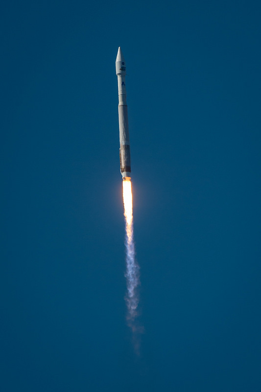
The United Launch Alliance (ULA) Atlas-V rocket with the Landsat Data Continuity Mission (LDCM) spacecraft onboard is seen as it launches on Monday, Feb. 11, 2013 at Vandenberg Air Force Base, California. Credit: NASA
Irons said the Landsat program is a critical and extremely valuable national asset.
“Since the launch of Landsat 1, we have seen — and we have caused — dramatic changes to the global land surface that continue today at rates unprecedented in human history,” he said. “These changes are due to an increasing population, advancing technologies and climate change. LDCM will extend and improve upon the Landsat record of landscape change. The resulting observations and information will be critical to managing increasing demands on land resources and preparing for inevitable changes to the global land surface.”
Recently, Landsat 5 successfully set the new Guinness World Records title for ‘Longest-operating Earth observation satellite.’ It was launched on March 1, 1984, and outlived its three-year design life. It delivered high-quality, global data of Earth’s land surface for 28 years and 10 months, completing over 150,000 orbits and sending back more than 2.5 million images of Earth’s surface. On Dec. 21, 2012 the USGS announced Landsat 5 would be decommissioned in the coming months after the failure of a redundant gyroscope. The satellite carries three gyroscopes for attitude control and needs two to maintain control.
The Landsat Program is managed by the U.S. Geological Survey (USGS).
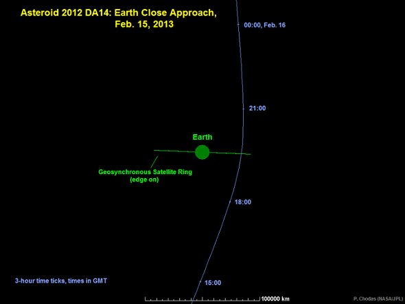
Mark your calendars: this Friday, February 15, 2013, is the close flyby of Near Earth Asteroid 2012 DA14, passing just 27,630 kilometers (17,168 miles) from the surface of the Earth. About 50 meters (164 feet) in size, 2012 DA14 and its close shave marks the the first time there has been passage of an asteroid this close that we’ve known a year beforehand. Yes, it passes within the ring of geosynchronous satellites girdling the Earth. No, there’s no danger, either to said satellites or the Earth, so Bruce Willis can stay home for this one. But right behind those inquiries, the question we most frequently get is… how can I see it?
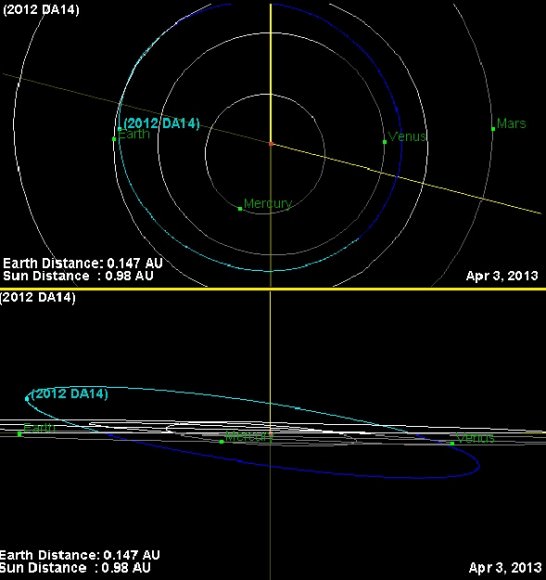
The orbital path of asteroid 2012 DA14 as seen face on (top) & near edge on (bottom). (Credit: JPL Small Body Database Browser).
The great news is that an advanced observer can indeed catch 2012 DA14 on its close pass the night of February 15th… with a little skill and luck. Now for the bad news; the asteroid won’t be visible without binoculars or a telescope, and North America will largely miss out.
2012 DA14 will be really moving across the sky on closest approach, covering 0.8° per minute, or the diameter of a Full Moon every 45 seconds! With its passage closer to the Earth than the ring of geosynchronous satellites, it’s worth treating the passage of the asteroid as a satellite and hunting it down accordingly. Catching and watching such a pass can be an unforgettable experience; not many objects in the sky show such swift motion in real time. In fact, 2012 DA14 will span the celestial sphere from declination -60° to +60° in just 4 hours! Needless to say, its passage through the Earth’s gravity well will alter its orbit considerably; most planetarium software programs do not account for this and thus will introduce a large error for a heliocentric object. Compounding the dilemma is the large amount of parallactic shift of such a nearby object. As viewed from the span of the Earth, 2012 DA14 will have a parallax of ~20° at greatest approach!
The path of asteroid 2012 DA14 through the celestial sphere on February 15th. (Created by Author).
But two sites on the web can help you with the search. One is Heavens-Above, which currently has a link on its main page to custom generate sky charts for specific locations for 2012 DA14 (make sure you’re logged in as a registered user and your observing location is set correctly). Another option is to generate an ephemeris customized for your location from the JPL Solar System Dynamics Horizons Web-Interface.
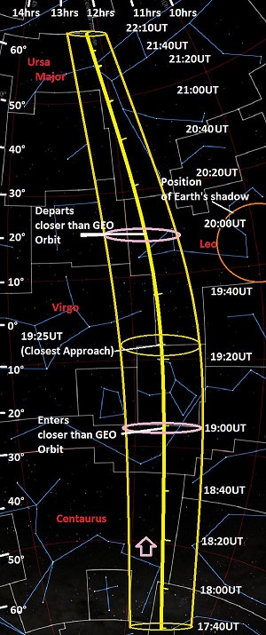
Asteroid 2012 DA14 is approaching the planet Earth from “down under,” and moving almost exactly parallel to the 12 hour line in right ascension. In fact, it’ll cross very near the equinoctial point in Virgo (one of the two points where the celestial equator and the ecliptic cross) shortly after its closest approach on Friday, February 15th at 19:25UT. The asteroid will be at the local zenith (straight overhead) for observers in the pre-dawn hours located in western Indonesia at closest approach. Australia and eastern Asia will have a shot at seeing the asteroid as it whizzes through the sky in the early morning hours of February 16th local. Observers in western Asia, Africa and Europe will see the asteroid lower to the east on the night of the 15th. Note that 2012 DA14 juuuuuust misses Earth’s shadow (see strip chart) at closest approach. The shadow of our fair planet is ~20° across at the distance of the geosynchronous satellites; had it passed about a month later, we would have seen an “asteroid eclipse!” In fact, “eclipse season” for geosynchronous satellites occurs right around the equinoxes and is only a month away.
The “banana strip chart” shows the path of 2012 DA14 from the time it reaches a magnitude brighter than +10 at 17:40UT until it dips back down below it at 22:10UT on the same night. It also shows the width of uncertainty for its position due to the aforementioned 20° of parallax, and the points that it enters and departs the distance sphere of the geosynchronous satellites. Keep in mind, these satellites still orbit roughly hundred times higher than the International Space Station!
A good search strategy to catch 2012 DA14 is to actually to treat it like you’re hunting for a faint satellite. Find the time that it’s crossing a set declination and begin scanning with binoculars in right ascension back and forth until you “ambush” your astronomical prey moving slowly against the starry background. If using a telescope, use the lowest power and widest field of view that the instrument will allow. We’ve used this technique in the past to sweep up Near Earth Asteroids 2005 YU55 and 99942 Apophis and routinely use it to hunt for satellites fainter than naked eye visibility. At closest approach, asteroid 2012 DA14 will shine at around +8th magnitude as it crosses the Bowl of Virgo northward past Denebola in the constellation Leo.
Recent measurements early this month conducted by astronomers at the Las Campanas observatory in Chile refined the orbit of 2012 DA14, placing its February 15th passage just 45 kilometres closer to Earth than previously calculated but still well outside the threat zone. Campaigns are underway to refine measurements of its orbit even further on this pass. We won’t get another close pass of 2012 DA14 until February 16th, 2046 when the asteroid misses us at about twice the distance of the Moon. An impact has been ruled out for this century. Predictions get less certain the further you project them into time, and 2012 DA14 will definitely be a space rock worth keeping tabs on!
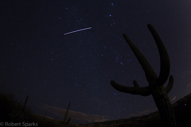
The International Space Station, as seen from Saguaro National Park East in Arizona. Credit: Robert Sparks.
Old meets space-age in this image of the International Space Station passing over an ancient saguaro cactus at the Saguaro National Park East near Tucson, Arizona. Robert Sparks (a.k.a. @halfastro or hale-bopp37 on Flickr) captured this beautiful image on February 6, 2013. While the ISS is just over 12 years old, the saguaro seen here could be upwards of 200 years old. These prickly old soldiers don’t usually start to grow arms until they are between 50 to 100 years of age, and they may live for perhaps 200 years or more.
Rob also captured the expanse of the awesome desert night sky, too.
Want to get your astrophoto featured on Universe Today? Join our Flickr group or send us your images by email (this means you’re giving us permission to post them). Please explain what’s in the picture, when you took it, the equipment you used, etc.
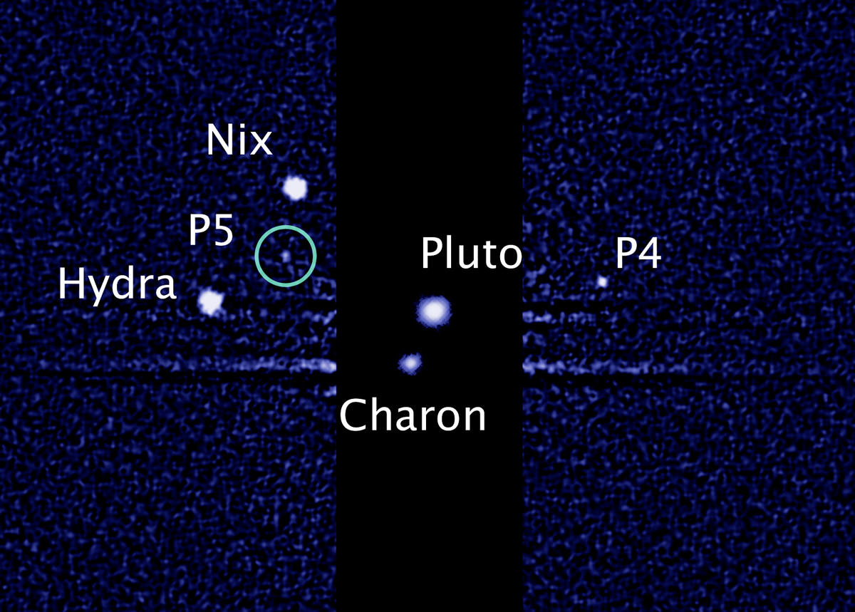
Pluto's known system of moons (NASA/ESA/M. Showalter))
Today marks seven months since the announcement of Pluto’s fifth moon and over a year and a half since the discovery of the one before that. But both moons still have letter-and-number designations, P5 and P4, respectively… not very imaginative, to say the least, and not really fitting into the pantheon of mythologically-named worlds in our Solar System.
Today, you can help change that.
According to the New Horizons research team, after the discovery of P4 in June 2011 it was decided to wait to see if any more moons were discovered in order to choose names that fit together as a pair, while a*lso following accepted IAU naming practices. Now, seven months after the announcement of P5, we think a decision is in order… and so does the P4/P5 Discovery Team at the SETI Institute.
“Hey, I can be democratic about all this!”
Today, SETI Senior Research Scientist Mark Showalter revealed a new poll site, Pluto Rocks, where visitors can place their votes on a selection of names for P4 and P5 — or even write in a suggestion of their own. In line with IAU convention these names are associated with the Greek and Roman mythology surrounding Pluto/Hades and his underworld-dwelling minions.
“In 1930, a little girl named Venetia Burney suggested that Clyde Tombaugh name his newly discovered planet ‘Pluto.’ Tombaugh liked the idea and the name stuck. I like to think that we are doing honor to Tombaugh’s legacy by now opening up the naming of Pluto’s two tiniest known moons to everyone.”
– Mark Showalter, SETI Institute
As of the time of this writing, the ongoing results look like this:
Results of Pluto Rocks voting as of Feb. 11, 2013 at 10 am EST (15:00 UT)
Do you like where the voting is headed? Are you hellishly opposed? Go place your vote now and make your opinion count in the naming of these two distant worlds!
(After all, New Horizons will be visiting Pluto in just under two and a half years, and she really should know how to greet the family.)
Voting ends at noon EST on Monday, February 25th, 2013.
The SETI team welcomes you to submit your vote every day, but only once per day so that voting is fair.
UPDATE: On Feb. 25, the final day of voting, the tally is looking like this:
PlutoRocks results as of Feb. 25, 2013 – Vulcan is in the lead, thanks to publicity from Mr. William Shatner
Thanks in no small part to a bit of publicity on Twitter by Captain Kirk himself, Mr. William Shatner (and support by Leonard Nimoy) “Vulcan” has made the list and warped straight to the lead. Will SETI and the IAU honor such Trek fan support with an official designation? We shall soon find out…
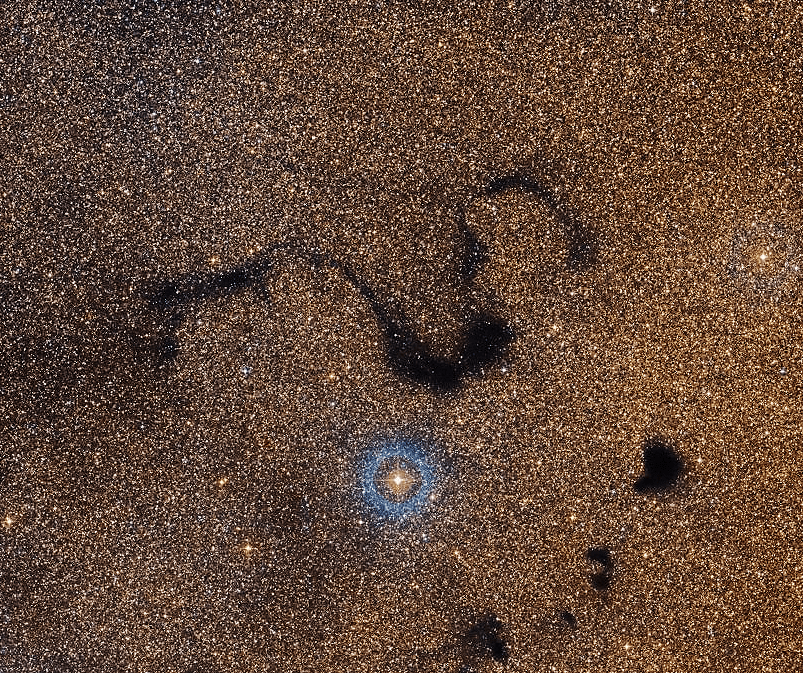
Gong Hey Fat Choy! Today marks the beginning of the Chinese New Year and what better way to celebrate the Year of the Black Snake than with a look at an enormous shadowy cosmic serpent, the Snake Nebula!
Also known as Barnard 72, the Snake Nebula is a meandering lane of dark dust located about 650 light-years away in the constellation Ophiuchus. Several light-years long, its opaque dust blocks our view of stars within the central bulge of the galaxy… but also reveals its presence since that region of the sky is literally filled with stars.
The bright star seen in the image just below the snake’s middle (looks like it may have just had dinner!) is HD 157398, a giant orange star 538 light-years from Earth. Here it shines brightly, but in the sky its visible magnitude is 6.67 — just a bit dimmer than what can be seen with the naked eye under the darkest skies.
Traveling to distant galaxies may have interesting consequences.
Credit: Hubble Release, Messier 106
Nearly four million light years away in the direction of the constellation of Canes Venatici, a visage of creation awaited to be revealed. Now, thanks to the teamwork of the astronomical image processors at the Space Telescope Science Institute in Baltimore, Maryland, and world-renowned astrophotographers Robert Gendler and Jay GaBany, we’re able to see combined Hubble Space Telescope data with ground-based telescope imaging. Let’s look deep into spiral galaxy, Messier 106.
This wasn’t an overnight imaging project. “A few months ago the Hubble Heritage Team contacted me and asked if I’d be interested in making a large format image of M106 from the available data on the Hubble Legacy Archive,” says Gendler. “I agreed and went to work downloading a large number of data sets from the HLA. I realized this would be a massive project. The image would be a mosaic of more than 30 panels and would incorporate both wideband and narrowband data sets.”
With the cooperation of Jay GaBany, they combined their own observations/images of this magnificent structure and compiled it with Hubble data – filling in areas where no data was available. The resulting image is a portrait of such depth and beauty that it’s almost like looking into the eyes of creation itself.
Be swept away…
If you’re drawn to the core of Messier 106, there’s good reason. It isn’t just an ordinary spiral galaxy, it’s one that has a peculiar jet flow which can be detected in radio and in H-alpha wavelengths. “Due to the special geometry of the galaxy, the jets emerge from the nuclear region through the galactic disk,” says Marita Krause (et al). “Also the distribution of molecular gas looks different from that in other spiral galaxies.” It is just this difference that makes NGC 4258 (M106) stand out a bit from the crowd and so worthy of further processing. According to new modeling techniques the “concentration of CO along the ridges is due to interaction of the rotating gas clouds with the jet’s magnetic field by ambipolar diffusion. This magnetic interaction is thought to increase the time the molecular clouds reside near the jet thus leading to the quasi-static CO ridge.”
Knowing those jets are present and the hunger to reveal them through imaging became the driving force for R. Jay GaBany. “Since the early 1960s, M106, also known as NGC 4258, has been known to exhibit an extra pair of arms, located between the spiral arms comprised of stars, dust and gas. But an explanation for their existence remained elusive until earlier in this decade,” says Jay. “My contribution to the image came from my 2010 image of M-106 that revealed the full extent of its amazing jets. My image include 22 hours of white light exposures through clear, red, blue and green filters plus and other 15 hours of imaging through a 6nm narrow band h-alpha filter.”
Messier 106 Courtesy of R. Jay GaBany
“Seen in the light emitted by hydrogen molecules when they become ionized, these arms display an artificial red hue to make them visible in the image I produced. The extra arms are now believed to be caused by high energy jets emanating from an active 40 million solar mass super-massive black hole menacing the galaxy’s center,” explains GaBany. “Because the jets are tilted at a low inclination they pierce the disk and surrounding halo of this galaxy. So, as the jets pass through regions of gas, they create an expanding cocoon of shock waves that heats the surrounding material causing it to release radiation in optical wavelengths. The curvature and fraying seen at their extremities represents previous trajectories of the jet due to past precession. Precession is a change in the orientation of the rotation axis of a spinning object. For example, the wobble of a spinning top.”
Yet, that’s not all. This low luminosity Seyfert II galaxy is also hosting a maser – its warped disk of water molecules discovered in 1994. Through radio observations, M106 became the first of its kind to show the exact location of the core of an AGN (active galactic nucleus). According to a study done by JR Herrnstein (et al): “NGC 4258 is an exceptional laboratory for the study of AGN accretion processes. The nuclear maser reveals details about the kinematics and structure of the accretion disk on subparsec scales and permits the determination of the central mass with great precision.”
And there is still more…
Deep inside lurks that known supermassive black hole – one that’s extremely active and produces bright microwave radiation. But, don’t stop there. Ordinarily a spiral galaxy has two arms, but M106 has double. These ethereal “extras” can be seen as faint ribbons of gas at optical wavelengths, but become solidified when viewed in x-ray and radio. Here the structure is formed in hot gas rather than stars. While this process was once a mystery to astronomers, new information suggests they may arise from the black hole activity, making them a unique artifact. What could cause it? These “extra arms” could be the result of the violent turbulence at the core – where gases are superheated and interact with their denser counterparts causing them to illuminate. At the perimeter of the galactic structure, the gases are more loose and the arching formation could be the product of the movement of jet activity.
“One goal I had early on was to feature the well known ‘anomalous arms’ of M106,” said Gendler. “This feature, peculiar to M106, is thought to arise from superheated gases, energized by accretion of matter into the galaxy’s massive black hole. The anomalous arms emit light in the visual spectrum around 656nm (hydrogen alpha) and I found a fair amount of hydrogen alpha data sets for the arms in the HLA.”
Gendler was responsible for all the image assembly and processing. “Assembling the image required over two months,” he said. “The quality of the data ranged from good to very poor. The central galaxy had sufficient color data but away from the center the Hubble data was incomplete and in some areas did not exist. I then decided to use ground based data from my own image and Jay GaBany’s image of M106 to fill in areas of missing or incomplete Hubble data. I also used ground based data to boost the signal of the outer areas of the galaxy as the Hubble data was sparse and of short exposure for the more remote areas of the galaxy.”
All in all, Messier 106 is a galaxy that deserves attention – attention and a loving touch given by two of the very best amateur astronomers and dedicated astrophotographers to be found.
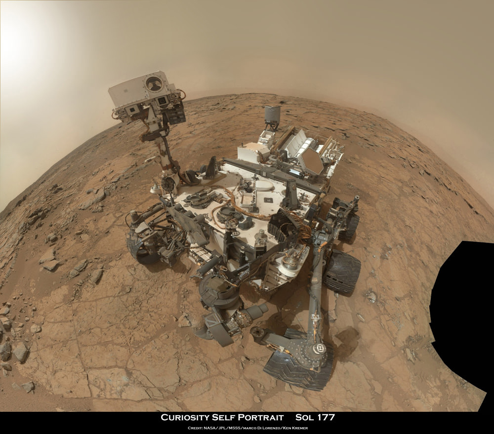
Rover self portrait MAHLI mosaic taken this week has Curiosity sitting on the flat rocks of the “John Klein” drilling target area within the Yellowknife Bay depression. Note gradual rise behind rover. Credit: NASA/JPL-Caltech/MSSS/Marco Di Lorenzo/www.KenKremer.com.
Earth’s most advanced planetary robot ever has successfully bored into the interior of Martian rock and collected fresh samples in a historic first time feat in humankinds exploration of the cosmos.
NASA’sCuriosity drilled a circular hole about 0.63 inch (16 mm) wide and about 2.5 inches (64 mm) deep into a red slab of fine-grained sedimentary rock rife with hydrated mineral veins of calcium sulfate – and produced a slurry of grey tailings surrounding the hole. The team believes this area repeatedly experienced percolation of flowing liquid water eons ago when Mars was warmer and wetter – and potentially more hospitable to the possible evolution of life.
The precision drilling took place on Friday, Feb. 8, 2013 on Sol 182 of the mission and images were just beamed back to Earth today, Saturday, Feb 9. The rover simultaneously celebrates 6 months on the Red Planet since the nail biting touchdown on Aug. 6, 2012 inside Gale Crater.
The entire rover team is overjoyed beyond compare after nearly a decade of painstakingly arduous efforts to design, assemble, launch and land the Curiosity Mars Science Laboratory (MSL) rover that culminated with history’s first ever drilling and sampling into a pristine alien rock on the surface of another planet in our Solar System.
“The most advanced planetary robot ever designed now is a fully operating analytical laboratory on Mars,” said John Grunsfeld, NASA associate administrator for the agency’s Science Mission Directorate.
“This is the biggest milestone accomplishment for the Curiosity team since the sky-crane landing last August, another proud day for America.”
Drilling goes to the heart of the mission. It is absolutely essential for collecting soil and rock samples to determine their chemical composition and searching for traces of organic molecules – the building blocks of life. The purpose is to elucidate whether Mars ever offered a habitable environment suitable for supporting Martian microbes, past pr present.
The high powered drill was the last of Curiosity’s 10 instruments still to be checked out and put into full operation.
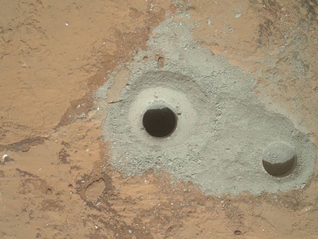
Curiosity’s First Sample Drilling hole is seen in this image at a rock called “John Klein”. The drilling took place on Feb. 8, 2013, or Sol 182 of operations. Several preparatory activities with the drill preceded this operation, including a test that produced the shallower hole on the right two days earlier, but the deeper hole resulted from the first use of the drill for rock sample collection. The image was obtained by Curiosity’s Mars Hand Lens Imager (MAHLI). The sample-collection hole is 0.63 inch (1.6 centimeters) in diameter and 2.5 inches (6.4 centimeters) deep. The “mini drill” test hole near it is the same diameter, with a depth of 0.8 inch (2 centimeters). Credit: NASA/JPL-Caltech/MSSS
The rover plunged the rotary-percussion drill located on the end of her 7 foot (2.1 m) robot arm into a flat outcrop of rocks named “John Klein”; where she is currently toiling away inside a shallow basin named Yellowknife Bay, and that witnessed many episodes of streaming water billions of years ago.
Ground controllers will now command the rover to pulverize and sieve the powdery rocky material through screens that will filter out any particles larger than six-thousandths of an inch (150 microns) across.
Thereafter comes the ultimate test – when the processed Martian powders are delivered by the robot arm to Curiosity’s miniaturized CheMin and SAM analytical labs though a trio of inlet ports located atop the rover deck for thorough analysis and scrutiny.
Curiosity used its Mast Camera (Mastcam) to take the images combined into this mosaic of the drill area, called “John Klein.” The label “Drill” indicates where the rover ultimately performed its first sample drilling. Shown on this mosaic are the four targets that were considered for drilling, all of which were analyzed by Curiosity’s instrument suite. At “Brock Inlier,” data from the Alpha Particle X-ray Spectrometer (APXS) and images from the Mars Hand Lens imager (MAHLI) were collected. The target “Wernecke” was brushed by the Dust Removal Tool (DRT) with complementary APXS, MAHLI, and Chemistry and Camera (ChemCam) analyses. Target “Thundercloud” was the subject of the drill checkout test known as “percuss on rock.” The target Drill was interrogated by APXS, MAHLI and ChemCam. Credit: NASA/JPL-Caltech/MSSS
“We commanded the first full-depth drilling, and we believe we have collected sufficient material from the rock to meet our objectives of hardware cleaning and sample drop-off,” said Avi Okon, drill cognizant engineer at NASA’s Jet Propulsion Laboratory (JPL), Pasadena.
Rock tailings generated from the 5/8 inch (16 mm) wide drill bit traveled up narrow flutes on the bit and then inside the drill’s chambers for transfer to the process handling mechanisms on the arm’s tool turret.
“We’ll take the powder we acquired and swish it around to scrub the internal surfaces of the drill bit assembly,” said JPL’s Scott McCloskey, drill systems engineer. “Then we’ll use the arm to transfer the powder out of the drill into the scoop, which will be our first chance to see the acquired sample.”
A portion of the material will first be used to scour and cleanse the labyrinth of processing chambers of trace contaminants possibly brought from Earth before launch from Cape Canaveral, Florida back in Nov. 2011.
Curiosity accomplished Historic 1st drilling into Martian rock at John Klein outcrop on Feb 8, 2013 (Sol 182), shown in this context mosaic view of the Yellowknife Bay basin taken on Jan. 26 (Sol 169) where the robot is currently working. The robotic arm is pressing down on the surface at John Klein outcrop of veined hydrated minerals – dramatically back dropped with her ultimate destination; Mount Sharp. Credit: NASA/JPL-Caltech/Ken Kremer (kenkremer.com)/Marco Di Lorenzo
The rock Curiosity drilled is called “John Klein” in memory of a Mars Science Laboratory deputy project manager who died in 2011.
Curiosity represents a quantum leap in capability beyond any prior landed mission on the Red Planet. The car sized 1 ton rover sports 10 state-of-the-art science instruments from the US and collaborators in Europe.
The 1 ton robot will continue working for several additional weeks investigating Yellowknife Bay and the Glenelg area – which lies at the junction of three different types of geologic terrain.
Thereafter, the six-wheeled mega rover will set off on a nearly year long trek to her main destination – the sedimentary layers of the lower reaches of the 3 mile (5 km) high mountain named Mount Sharp – some 6 miles (10 km) away.
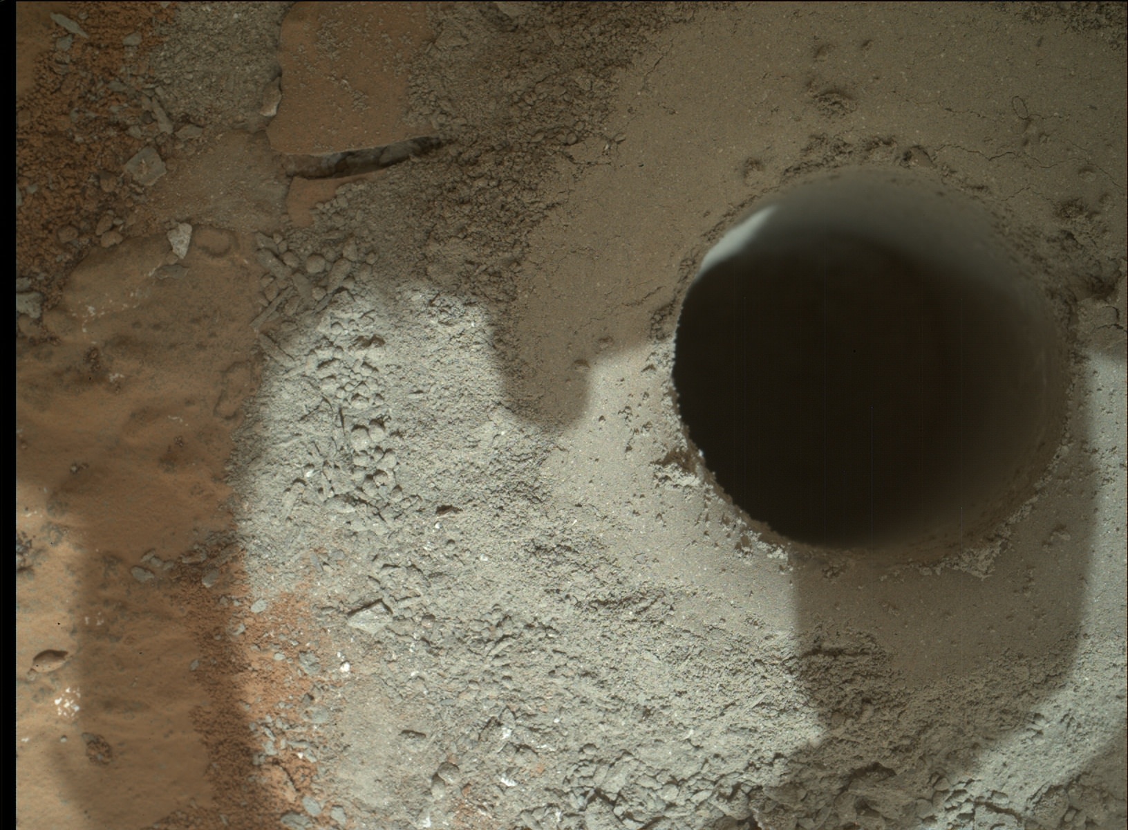
What a hole on Mars ! Alien hole on an Alien Planet. Curiosity precisely bores to a depth of 2.5 inches (64 mm) into water altered rock. Credit: NASA/JPL-Caltech/MSSSSide view of Curiosity’s Drill Bit Tip. The bit is about 0.6 inch (1.6 centimeters) wide. This view from the remote micro-imager of the ChemCam instrument merges three exposures taken by the camera at different focus settings to show more of the hardware in focus than would be seen in a single exposure. Images taken on Sol 172, Jan 29, 2013. Credit: NASA/JPL-Caltech/LANL/CNES/IRAP/LPGNantes/CNRS
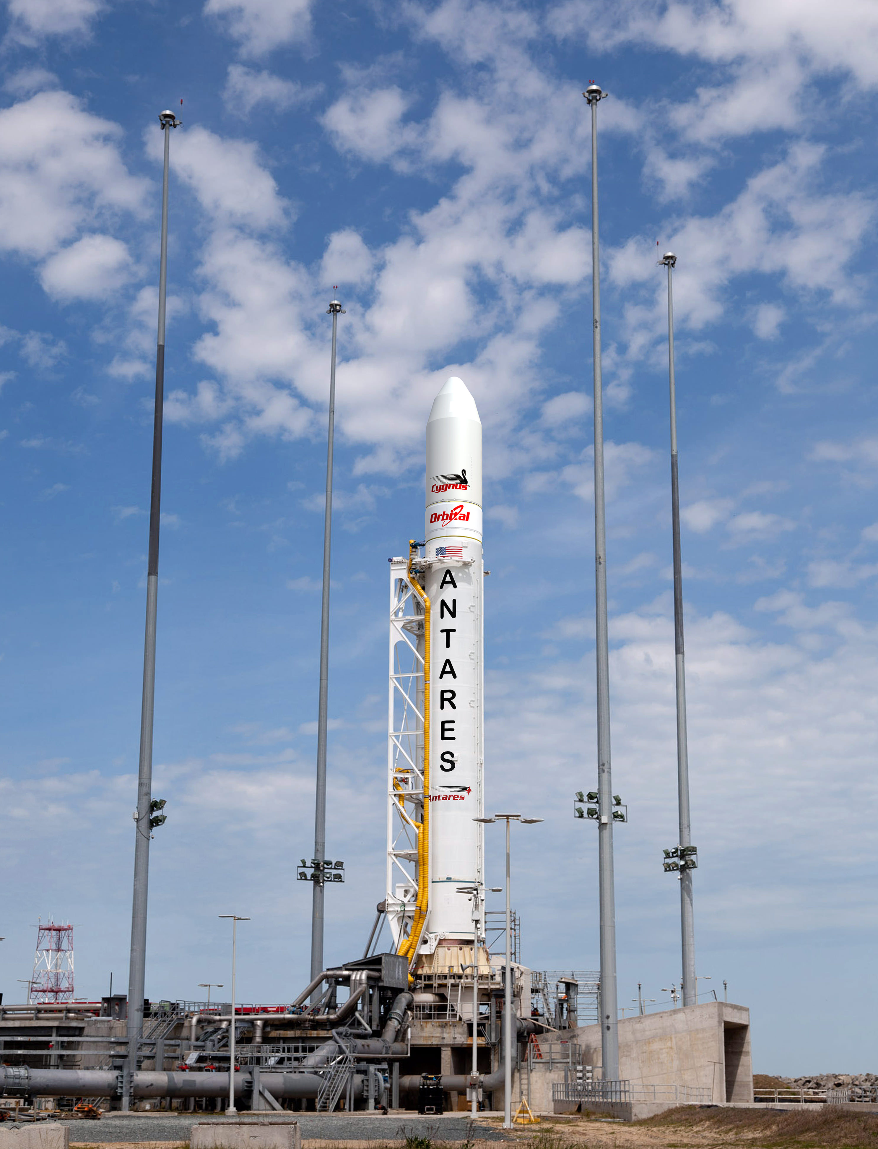
Orbital Antares rocket at Wallops Island Pad. Credit: Orbital Sciences
Orbital Sciences Corporation has at last scheduled a critical engine test for the firm’s new commercially developed Antares medium class rocket for Feb. 12 at the Mid-Atlantic Regional Spaceport’s (MARS) Pad-0A.
NASA’s Wallops Flight Facility will provide launch range support for the Antares rocket test which is a key milestone on the path to a flight that is crucial for eventual resupply of the International Space Station (ISS).
The window for the 29 second long engine test is 6-9 p.m EST. There will be no live broadcast or formal viewing of the test since it is only operational in nature.
For this hot fire test only the first stage of the Antares rocket will be rolled out to the launch pad – the first of its kind constructed in America in several decades.
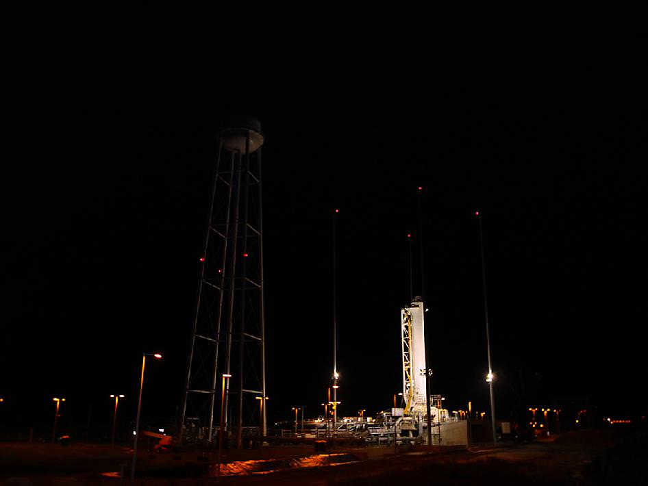
The first stage of the Antares rocket stands on the pad at NASA’s Wallops Flight Facility. Credit: Orbital Sciences
During the test, the Antares’ dual AJ26 first stage rocket engines will generate a combined total thrust of 680,000 lbs. In a unique capability for its duration, the rocket will be held down on the pad and accounts for the huge water tower built nearby.
The goal of the hot fire test is a complete checkout of the rocket’s first stage and all the support systems at Pad-0A being utilized for the first time.
Antares is the launcher for Orbital’s unmanned commercial Cygnus cargo spacecraft that NASA’s hopes will further reestablish American resupply missions to the International Space Station (ISS) lost with the shuttle’s shutdown.
If successful, a full up test flight of the 131 foot tall Antares with a Cygnus mass simulator bolted on top is planned for the maiden launch in roughly 4 to 6 weeks later, perhaps by late March 2013.
Antares/Cygnus will provide a similar service to the Falcon 9/Dragon system developed by SpaceX Corporation – which has already docked twice to the ISS during historic linkups in 2012.
Both the Orbital and SpaceX systems were developed under NASA’s Commercial Orbital Transportation Services (COTS) program to replace the ISS cargo capability previously tasked to NASA Space Shuttle’s.
A docking demonstration mission to the ISS would follow later in 2013 which would be nearly identical in scope to the SpaceX Falcon 9/Dragon demonstration flight successfully accomplished in May 2012.
SpaceX Falcon 9 rocket liftoff on May 22, 2012 from Space Launch Complex-40 at Cape Canaveral Air Force Station, Fla., on the first commercial mission to the International Space Station. Orbital hopes to duplicate the SpaceX feat in 2013. Credit: Ken Kremer
The Antares first stage is powered by a pair of Soviet era NK-33 engines built during the 1960 and 1970’s as part of Russia’s ill-fated N-1 manned moon program. The engines have since been upgraded and requalified by Aerojet Corp. and integrated into the Ukrainian built first stage rocket as AJ-26 engines.
Tens of millions of US East Coast residents in the Mid-Atlantic and Northeast regions have never seen anything as powerful as an Antares rocket launch in their neighborhood.
“Antares is the biggest rocket ever launched from Wallops,” NASA Wallops spokesman Keith Koehler told me.
Chris Hadfield in the Cupola of the ISS. Credit: NASA
Canadian astronaut Chris Hadfield participated in an annual event for Canadian music students from a unique location: a long-distance perch in the Cupola of the International Space Station. Before launching to the ISS in December, Hadfield wrote a song with Ed Robertson of the band Barenaked Ladies, and Friday morning the song premiered as Hadfield, Robertson and a school glee club sang together: Hadfield performed his part on the space station; Robertson did his in Toronto with the Wexford Gleeks. The song was part of Music Monday in Canada, and while today’s premiere was pre-recorded, in May, students across Canada will play the song live with Hadfield in space.
The song is called “I.S.S. (Is Somebody Singing),” it begins with the words:
Eighteen-thousand miles an hour
Fueled by science and solar power
The oceans racing past
At half a thousand tons
Ninety minutes moon to sun
A bullet can’t go half this fast.
Music aficionados can find the sheet music here and here.
Hadfield plays the guitar and sings with a couple of bands on Earth. Before he began his Expedition on the ISS, he told Universe Today he would be doing as much singing as he could in space.
“Music is really important to me, ever since I’ve been a kid. I’ve always played guitar and sang,” he said, “and I’m really hoping to have the chance to sit weightless with the guitar on board and play music, and also record some of the music I’ve written.”
He also is working to finish some songs he started writing on Earth while living on the ISS, which he called “a particularly inspirational environment” and maybe write some news ones.
“We have all the recording equipment we need on board,” he said. “It is basic but it is good enough to be able to record and I’m hoping to record at least one full CD’s worth of original music up there. It’s neat – I’m writing with my brother who is a musician, and he pointed out that a lot of the traditional folk songs came from people who were the first on the frontier — the early explorers, sailors, miners, and the fishermen — the people who are involved in the day-to-day of a specific human experience. To think I might be involved in helping to write some of the first space faring music, music that people might play and sing as they leave Earth for Mars, it is an interesting time in history.”