Curiosity’s Rambling Tracks Visible from Mars Orbit

Tracks from the Curiosity rover were imaged by the HiRISE camera on the Mars Reconnaissance Orbiter on January 2, 2012. Credit: NASA/JPL/University of Arizona.

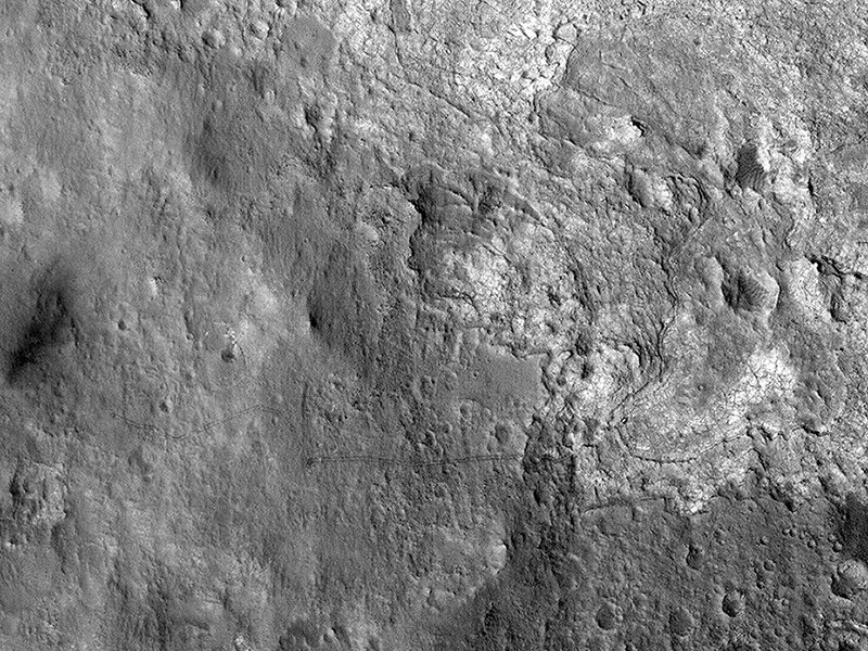
Look closely and see where the Curiosity rover has been roving about inside Gale Crater on Mars, from “Bradbury Landing” to its current location in “Yellowknife Bay.” This shot was taken by the HiRISE camera on board the Mars Reconnaissance Orbiter on January 2, 2013.

“This image shows the entire distance traveled from the landing site (dark smudge at left) to its location as of 2 January 2013 (the rover is bright feature at right),” wrote HiRISE principal investigator Alfred McEwen on the HiRISE website. “The tracks are not seen where the rover has recently driven over the lighter-toned surface, which may be more indurated [hardened] than the darker soil.”

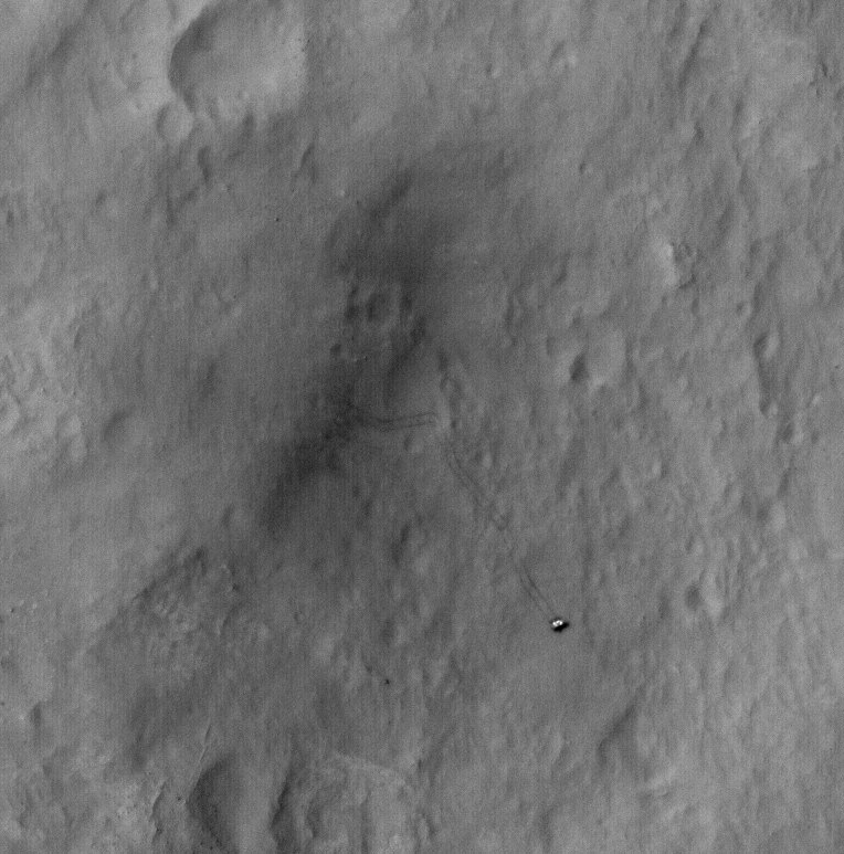
You can compare this image to one taken on September 8, 2012 to see how much the rover has driven in Gale Crater:

Curiosity rover tracks seen from orbit by HiRISE on September 8, 2012. Credit: NASA/JPL/University of Arizona.

And here’s a map of Curiosity’s travels that NASA released yesterday:

This image maps the traverse of NASA's Mars rover Curiosity from "Bradbury Landing" to "Yellowknife Bay," with an inset documenting a change in the ground's thermal properties with arrival at a different type of terrain. Image credit: NASA/JPL-Caltech/Univ. of Arizona/CAB(CSIC-INTA)/FMI.

Mission scientists said at a briefing yesterday (January 15, 2013) that between Sol (Martian day) 120 and Sol 121 of the mission — which equates to Dec. 7 and Dec. 8, 2012 — Curiosity crossed over a terrain boundary into lighter-toned rocks that correspond to high thermal inertia values observed by NASA’s Mars Odyssey orbiter. The green dashed line marks the boundary between the terrain types.

The inset graphs the range in ground temperature recorded each day by the Rover Environmental Monitoring Station (REMS) on Curiosity. Note that the arrival onto the lighter-toned terrain corresponds with an abrupt shift in the range of daily ground temperatures to a consistently smaller spread in values. This independently signals the same transition seen from orbit, and marks the arrival at well-exposed, stratified bedrock.

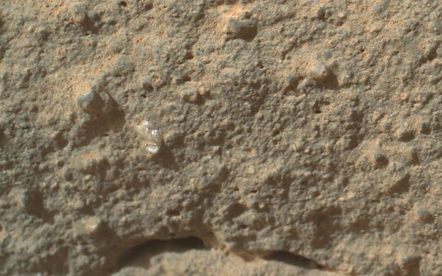
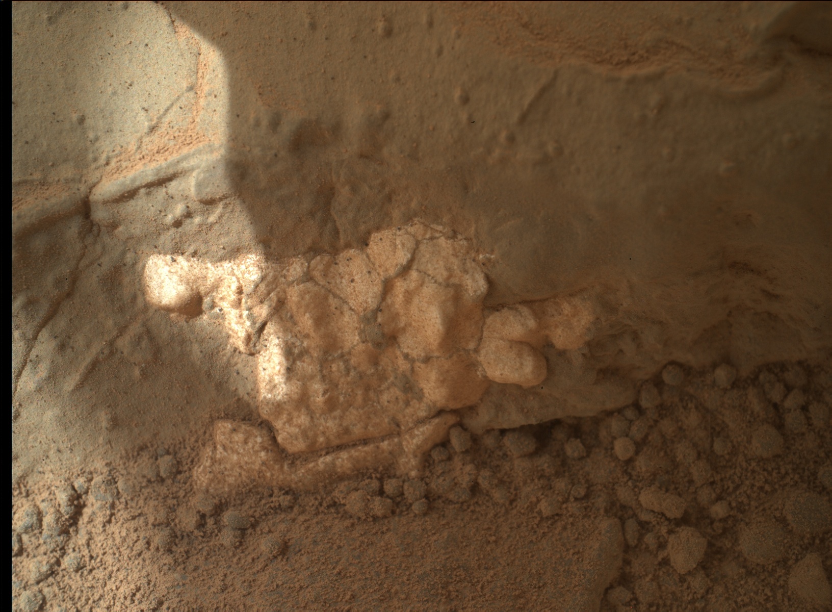
Sol 124 (Dec. 11, 2012) marked the arrival into an area called “Yellowknife Bay,” where sulfate-filled veins and concretions were discovered, along with much finer-grained sediments providing evidence of past water interacting with the surface.

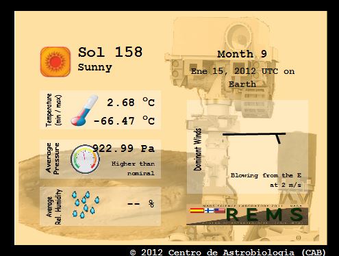
Here’s the Mars weather report provided by REMS for Sol 158 (January 15, 2013):

Daily Weather Report
Image credit: NASA/JPL-Caltech.
Daily Weather Report. Image credit: NASA/JPL-Caltech.

A video showing the new HiRISE image of Curiosity’s tracks:

Space Station Gets a New Telescope

Canadian astronaut Chris Hadfield with the new ISERV (International Space Station SERVIR Environmental Research and Visualization System), a modified Celestron telescope for Earth observation. Credit: NASA/CSA

Astronauts on the International Space Station today are installing a new modified Celestron telescope. This won’t be used to observe the stars, but instead look back to Earth to acquire imagery of specific areas of the world for disaster analysis and environmental studies. Called ISERV (International Space Station SERVIR Environmental Research and Visualization System), it is a new remote-controlled imaging system.

“Essentially, it will be pointed out of one of the windows of the Space Station, and used for Earth imaging,” Andrea Tabor, social media coordinator for Celestron told Universe Today, “especially for natural disasters and to help countries that may not have their own Earth-observing satellites to help assess damage and assist with evacuations.”

ISERV will be installed in the Window Observational Research Facility (WORF) in the station’s Destiny laboratory.

The Celestron CPC 925, is a 9.25″ diffraction limited Schmidt-Cassegrain telescope and off-the-shelf sells for $2,500 including the mount, (just the 9.25 inch optical tube sells for $1,479). It was modified at the Marshall Space Flight Center.

“They used the fork mount that comes with it,” Tabor said, “but they just removed the tripod and replaced it with a specialized mount to anchor and stabilize it on the ISS.”

Because it is pointed out of a window and because the ISS is moving so fast, it would be difficult to align it with the sky and do any celestial imaging, Tabor said.

ISERV is the first of what is hoped to be a series of space station Earth-observing instruments, each to feature progressively more capable sensors to help scientists gain operational experience and expertise, as well as help design better systems in the future. Scientists envision that future sensors could be mounted on the exterior of the station for a clearer, wider view of Earth.

It arrived on the ISS in July of 2012 on board the Japanese HTV-3.

“It’s been up there sitting in a box, so today was unboxing and assembly day,” Tabor said. She added that they hope to post some of the first images from the telescope on their Twitter and Facebook pages.

The telescope will normally be operated by remote-controlled from Earth and so the astronauts won’t likely be working with it directly except for assessing its operation or troubleshooting any problems.

“Images captured from ISERV on the ISS could provide valuable information back here on Earth,” said Dan Irwin, SERVIR program director at Marshall. “We hope it will provide new data and information from space related to natural disasters, environmental crises and the increased effects of climate variability on human populations.”

Image via @Cmdr_Hadfield on Twitter

Dark Nebula Hides Star Birth

A new image from ESO shows a dark cloud where new stars are forming along with a cluster of brilliant stars that have already emerged from their dusty stellar nursery. Credit: ESO/F. Comeron.

Dark nebulas, or dark clouds in space are intriguing because they appear to be “holes” in the sky where there aren’t any stars. But they really are just blocking our view. Also called absorption nebulas, these dark, smokey clouds of gas and dust block light from the regions of space behind it. This new image from ESO shows a dark cloud called Lupus 3 along with a cluster of brilliant stars.

While the dark cloud and the bright cluster of stars appear to be very different, they are in fact closely linked. The cloud contains huge amounts of cool cosmic dust and is a nursery where new stars are being born. We likely wouldn’t be able to see the absorption nebula unless it was silhouetted against the much brighter region of space produced by the star cluster, since absorption nebulas do not create their own light.

As light from space reaches an absorption nebula it is absorbed by it and does not pass through. It is likely that the Sun formed in a similar star formation region more than four billion years ago. The stars seen here are probably less than one million years old.

Lupus 3 lies about 600 light-years from Earth in the constellation of Scorpius. The dark section shown here is about five light-years across.

The new picture was taken with the MPG/ESO 2.2-metre telescope at the La Silla Observatory in Chile and is the best image ever taken in visible light of this little-known object.

Source: ESO

New South Pole Marker Honors Planets, Pluto, and Armstrong

The new geographic South Pole marker that stands at 90º S latitude. (Credit: Jeffrey Donenfeld)

Because the Amundsen-Scott South Pole Station sits atop a layer of moving ice almost 2 miles thick, the location of the marker for the Earth’s geographic South Pole needs to be relocated regularly. Tradition has this done on New Year’s Day, and so this past January 1 saw the unveiling of the newest South Pole marker: a beautiful brass-and-copper design created by Station machinist Derek Aboltins.

pole-marker-top-closeup-1The top of the marker has seven small discs that represent the planets in the positions they would be in on Jan. 1, 2013, as well as two larger discs representing the setting Sun and Moon. Next to the Moon disc are the engraved words “Accomplishment & Modesty,” a nod to the first man on the Moon.

“This was a reference to honor Neil Armstrong, as he passed away when I was making this section with the moon,” Aboltins said.

And for folks who might think the planet count on the new marker is one too few, a surprise has been tucked away on the reverse side.

“For those of you who still think Pluto should be a planet, you’ll find it included underneath, just to keep everyone happy,” Aboltins said. “Bring back Pluto, I say!”

And so, on the underside of the marker along with the signatures of South Pole Station researchers and workers, is one more disc — just for the distant “demoted” dwarf planet.

pole-marker-underside

Underside of the South Pole marker (Credit: Jeffrey Donenfeld)

“For those of you who still think Pluto should be a planet, you’ll find it included underneath, just to keep everyone happy!”

– Derek Aboltins, designer and machinist

(See high resolution versions of these images here.)

The marker was placed during a ceremony on the ice on Jan. 1, during which time the previous flag marker was removed and put into its new position.

8375171352_5f2b446640_b

(Photo credit: Jeffrey Donenfeld)

According to The Antarctic Sun:

“Almost all hands were present for the ceremony, including station manager Bill Coughran, winter site manager Weeks Heist, and National Science Foundation representative Vladimir Papitashvili. The weather was sunny and a warm at just below minus 14 degrees Fahrenheit.”

(Even though it’s mid-summer in Antarctica, “warm” is clearly a relative term!)

Read more about this and other Antarctic news on The Antarctic Sun site, and see more photos from Antarctica by Jeffrey Donenfeld here.

_____________________

Named for explorers Roald Amundsen and Robert F. Scott, who attained the South Pole in 1911 and 1912, the Amundsen-Scott South Pole Station stands at an elevation of 2,835 meters (9,306 feet) on Antarctica’s ice sheet, which is about 2,700 meters (9,000 feet) thick at that location. The station drifts with the ice sheet at about 10 meters (33 feet) each year. Research is conducted at the station in the fields of astronomy, astrophysics, glaciology, geophysics and seismology, ocean and climate systems, biology, and medicine.

About That ‘Flower’ on Mars….

A bright and interestingly shaped tiny pebble shows up among the soil on a rock, called "Gillespie Lake," which was imaged by Curiosity's Mars Hand Lens Imager on Dec. 19, 2012, the 132nd sol, or Martian day of Curiosity's mission on Mars. Credit: NASA / JPL-Caltech / MSSS.

The Curiosity rover is having a “field day” exploring the rocks in a shallow depression that scientists call ‘Yellowknife Bay,’ which is chock-full of light toned rocks. One small rock or feature – the size of a pebble or large grain of sand, actually – has caught the attention of many as it looks like a little flower. Keep in mind that this pebble is about 2 millimeters in size (a US dime coin is 1.35mm thick) so that’s really teeny tiny. But through the power of zooming in to the high resolution images of the Mars Hand Lens Imager, or MAHLI, there have been people who are convinced this is some sort of flora on Mars, or perhaps a fossil.

Initially, it was suggested that this could perhaps be a piece of plastic from the rover, similar to what was found earlier, but the MSL scientists quickly determined this was actually part of the rock.

Today, deputy principal investigator of MAHLI, Aileen Yingst of the Planetary Science Institute, told reporters that the big rock of which the flower is a part, named ‘Gillespie Lake,’ is a relatively dust free, coarse grained sandstone, with several larger grains in the matrix, “which are interesting because of their color, luster and shape,” she said, and this unusually shaped grain is lighter in color – almost opaque — which indicates it could be made of something different than the rest of the rock.

What is it?

“It could be a lot of things, but without some chemical information to back me up, I’d really hesitate to say what it is,” said Yingst. “I’m not trying to be cagey, I’m just trying to be clear that a light grain could be a lot of different things.”

But what really matters is what the team is finding out about this region, as those rounded grains provide a clue to the history of this area.

“They’ve been knocked around, they’ve been busted up,” said Yingst. “They’ve been rounded by some process.

This suggests that flowing water helped form this rock.

Yingst also stressed that this feature is not biological, “But it does indicate that you have a relatively diverse set of grains just in this one sample,” she said.

So, water in the past but no flowers on Mars.

The rover has also found water-deposited mineral veins that fill fissures in the rocks, such as in the image below.

The team will continue to study this area, and have chosen a rock on which to use the rover’s drill for the first time.

Light-toned veins in the rocks in Yellowknife Bay. Credit: NASA/JPL/Malin Space Science Systems.

See more images from today’s briefing here.

A Hi-Res Mosaic of Mercury’s Crescent

A view of Mercury from MESSENGER’s October 2008 flyby (NASA / JHUAPL / Gordan Ugarkovic)

Every now and then a new gem of a color-composite appears in the Flickr photostream of Gordan Ugarkovic, and this one is the latest to materialize.

This is a view of Mercury as seen by NASA’s MESSENGER spacecraft during a flyby in October 2008. The image is a composite of twenty separate frames acquired with MESSENGER’s narrow-angle camera from distances ranging from 18,900 to 17,700 kilometers and colorized with color data from the spacecraft’s wide-angle camera. (North is to the right.)

Click the image for a closer look, and for an even bigger planet-sized version click here. Beautiful!

The images that made up this mosaic were taken two and a half years before MESSENGER entered orbit around Mercury on March 19, 2011 UT, becoming the first spacecraft ever to do so and making Mercury the final “classical” planet to be orbited by a manmade spacecraft.

Since that time MESSENGER has completed well over 1,000 orbits and taken more than 100,000 images of the first planet in the Solar System, which filled in most of our gaps in Mercury’s map and showed us many never-before-seen features of the planet’s Sun-scoured surface. And just this past year MESSENGER’s extended mission helped confirm what could be called its most important discovery of all: water ice on Mercury’s north pole.

2012_Year_Highlights-1This was even selected by Scientific American as one of the Top 5 Space Stories of 2012.

With all that’s been achieved by MESSENGER in 2011 and 2012, 2013 is looking to be an interesting year!

“We learned a great deal about Mercury over the past year,” said MESSENGER Principal Investigator Sean Solomon of Columbia University’s Lamont-Doherty Earth Observatory. “The team published three dozen scientific and technical papers and delivered more than 150 presentations at national and international meetings. New measurements continue to stream back from our spacecraft, and we can look forward with excitement to many additional discoveries in 2013.”

Follow the MESSENGER mission news here and see more of Gordan’s space images here.

Inset image: 12 Mercurial discoveries by MESSENGER in 2012. Click to review.

Absolutely Stunning 3-D View of a Cosmic Cloud

Melotte 15 via the Hubble Space Telescope.

To call Finnish astrophotographer J-P Metsävainio a magician is definitely not an exaggeration! Take a look at his latest handiwork, this amazing 3-D animation of Melotte 15 in the Heart Nebula, IC 1805.

Metsävainio has previously produced outstanding images in 3-D the usual way, with stereo pairs and anaglyphs, but his new experimental 3-D work is incredible!

He explained to Universe Today how he created this and other 3-D animations:

Melotte 15. Credit: J-P Metsävainio.

“My 3-D experiments are a mixture of science and an artistic impression,” he said via email. “I collect distance and other information before I do my 3-D conversion. Usually there are known stars, coursing the ionization, so I can place them at right relative distance. If I know a distance to the nebula, I can fine tune distances of the stars so, that right amount of stars are front and behind of the object.”

He uses a “rule of thumb” method for stars: brighter is closer, but if a real distance is known, he uses that. Many 3-D shapes can be figured out just by looking carefully the structures in nebula, such as dark nebulae must be at front of the emission nebulae in order to show up.

“The general structure of many star forming regions is very same,” Metsävainio explained. “In this image, there is a group of newly born young stars, as an open cluster inside of the nebula. The stellar wind from the stars is then blowing the gas away around the cluster and forming a kind of cavitation – or a hole — around it. The pillar-like formations in the nebula must point to a source of stellar wind, for the same reason.”

For just the observing alone, this image is forty-five 1,200 second exposures (that equals 15 hours!)

He compared his processing workflow to sculpting, and said the result is always an approximate reality.

“How accurate the final model is, depends how much I have known and guessed right,” he said. “The motivation to make those 3-D-studies is just to show, that objects in the images are not like paintings on the canvas but really three dimensional objects floating in the three dimensional space.”

Another reason he creates these time-intensive 3-D animations is because they are fun to do, in addition to the old adage of why we do anything: “Because I can,” he said.

“This generally adds a new dimension to my hobby as an astronomical imager — (Pun intended),” he said.

Here is a link to more of Metsävainio’s 3-D imagery and here is his portfolio website: http://astroanarchy.zenfolio.com/.

Use Red/Cyan 3-D glasses to see this great animation of the Moon.

Thanks to J-P Metsävainio for allowing us to share his images!

Crescent Moon Photos from Around the World

Venus and the Moon on 1-10-13 from Tucson, Arizona. Credit: Robert Sparks

For the past week or so, we’ve had either a waxing or waning crescent Moon (save for the New Moon on January 11) and astrophotographers have been out in full force capturing the beauty of this sliver of light, and sometimes, like the image above by Rob Sparks (hale_bopp37 on Flickr) even a little Earthshine. Enjoy these stunning photos from our readers around the world!

Luna, January 14, 2013. Credit: Raymond Gilchrist
Luna, January 14, 2013. Credit and copyright: Raymond Gilchrist
The 2% waxing crescent Moon at sunset, January 12, 2013. Credit and copyright, Tavi Greiner.
Waxing crescent Moon on January 14, 2013. Credit and copyright: Sculptor Lil on Flickr.
Waxing crescent Moon on January 14, 2013 from London, England. Credit and copyright: Sculptor Lil on Flickr.
The crescent Moon taken at sunrise on  January 9, 2013 from Carmyllie, Scotland. Credit and copyright: Mike Walton.
The crescent Moon taken at sunrise on January 9, 2013 from Carmyllie, Scotland. Credit and copyright: Mike Walton.
Earthshine on January 15, 2013 from Kuala Lumpur. Credit and copyright: Shahrin Ahmad.
The crescent Moon -- the 'easy way' -- a hand-held camera, no tripod, just Lumix DMC-FZ48 at max. optical zoom. Credit and copyright: Daniel Fischer.
The crescent Moon -- the 'easy way' -- a hand-held camera, no tripod, just a Lumix DMC-FZ48 at maximum optical zoom. Credit and copyright: Daniel Fischer.

Astrophotographer (and blogger) Daniel Fischer notes that his image, above, was taken freehand with a simple camera, “a ‘work’ of a few seconds,” he said. “Might encourage others to give it a try with their own cameras.”

Want to get your astrophoto featured on Universe Today? Join our Flickr group or send us your images by email (this means you’re giving us permission to post them). Please explain what’s in the picture, when you took it, the equipment you used, etc.

Blast it Wedge, We’re Not Getting a Death Star

The Death Star in Star Wars. Credit: Lucasfilm.

Well, it’s official. The Obama Administration has said no to a petition asking the US government to build a Death Star. On the “We the People” petition site, if a petition gets 25,000 people to sign, the Obama administration has promised to reply. There have been some really crazy petitions put forth – one person wanted to be named emperor, another wanted a statue built – but there have been some creative and meaningful petitions as well. Then there’s the petition to “Secure resources and funding, and begin construction of a Death Star by 2016.” Creative… yes. Meaningful? Probably not, but it certainly got a lot of attention.

And Paul Shawcross, the Chief of the Science and Space Branch at the White House Office of Management and Budget, who replied to this petition, did right by Star Wars and sci-fi fans, and in an imaginative and inspiring way.

Titled “This isn’t the Petition Response You’re Looking For,” Shawcross’s response said the real reasons we won’t get a Death Star is because:
1. The construction of the Death Star has been estimated to cost more than $850,000,000,000,000,000. We’re working hard to reduce the deficit, not expand it.
2. The Administration does not support blowing up planets.
3. Why would we spend countless taxpayer dollars on a Death Star with a fundamental flaw that can be exploited by a one-man starship?

He outlined how we already have a space station, a laser-wielding robot on Mars, and are discovering hundreds of new planets orbiting other stars.

“We are living in the future! Enjoy it,” Shawcross wrote. “Or better yet, help build it by pursuing a career in a science, technology, engineering or math-related field…. If you do pursue a career in a science, technology, engineering or math-related field, the Force will be with us! Remember, the Death Star’s power to destroy a planet, or even a whole star system, is insignificant next to the power of the Force.”

There’s still time to sign the petition for looking into building a working version of the Starship Enterprise; right not that petition has just over 6,000 signatures.

Late addition:

Via StarWars.com comes the news that evil Empire has posted a response to the White House’s decision not to build a Death Star:

IMPERIAL CENTER, CORUSCANT – The overwhelming military superiority of the Galactic Empire has been confirmed once again by the recent announcement by the President of the United States that his nation would not attempt to build a Death Star, despite the bellicose demands of the people of his tiny, aggressive planet. “It is doubtless that such a technological terror in the hands of so primitive a world would be used to upset the peace and sanctity of the citizens of the Galactic Empire,” said Governor Wilhuff Tarkin of the Outer Rim Territories. “Such destructive power can only be wielded to protect and defend by so enlightened a leader as Emperor Palpatine.”
Representatives on behalf of the nation-state leader from the unimaginatively named planet refused to acknowledge the obvious cowardice of their choice, preferring instead to attribute the decision to fiscal responsibility. “The costs of construction they cited were ridiculously overestimated, though I suppose we must keep in mind that this miniscule planet does not have our massive means of production,” added Admiral Conan Motti of the Imperial Starfleet.

Emissaries of the Emperor also caution any seditious elements within the Galactic Senate not to believe Earth’s exaggerated claims of there being a weakness in the Death Star design. “Any attacks made upon such a station – should one ever be built – would be a useless gesture,” added Motti.

This article was updated on January 15, 2013.

Amazing Map Is Made Up Of Everyone in the U.S. and Canada


Zoomable map of the US and Canada pinpoints everyone with a dot. (Credit: Brandon Martin-Anderson/Census Dotmap)

Now this is something different: an interactive and zoomable map of the United States and Canada, made not from political boundaries or geographic landforms but rather of tiny dots — 341,817, 095 of them, to be exact — each one representing an individual person counted in the 2010 (US) and 2011 (Canada) censuses. There’s no other feature on this map except those dots, each randomly placed within the regional blocks used by the census, yet we still end up with a very recognizable structure.

So if you were listed in either of these censuses, you helped to make this map!

The Census Dotmap is a project by Brandon Martin-Anderson, who wanted an image of human settlement patterns that didn’t use political boundaries. He wrote a script that organized all the census data into points that got drawn into the block-level counts… well, you can see more about how he made it here.

(Just how accurate are population counts? According to the US Census Bureau, the 2010 count was “exemplary”… although renters and certain minority groups are traditionally undercounted.)

Screen Shot 2013-01-14 at 5.13.18 PM


Dotmap of the Vancouver, BC area

The bottom line is that this is really interesting to explore… if you live in a somewhat remote area, and you see a dot there, most likely that’s you! (It’s a little harder to determine who’s who in the more populated areas… the dots don’t pinpoint specific street addresses.)

And yes, Alaska and Hawaii are on there too… they just didn’t fit in the screenshot above. In fact all of northern Canada is there too, the dots are just very few and widely spaced out. But it’s not blank.

Check it out… you can even buy a print of the entire map, or a particular region or city. Now that’s leaving your mark on the world!

Credit: Brandon Martin-Anderson. Tip of the hat to Inkwell Communications.