A Hi-Res Mosaic of Mercury’s Crescent

A view of Mercury from MESSENGER’s October 2008 flyby (NASA / JHUAPL / Gordan Ugarkovic)

Every now and then a new gem of a color-composite appears in the Flickr photostream of Gordan Ugarkovic, and this one is the latest to materialize.

This is a view of Mercury as seen by NASA’s MESSENGER spacecraft during a flyby in October 2008. The image is a composite of twenty separate frames acquired with MESSENGER’s narrow-angle camera from distances ranging from 18,900 to 17,700 kilometers and colorized with color data from the spacecraft’s wide-angle camera. (North is to the right.)

Click the image for a closer look, and for an even bigger planet-sized version click here. Beautiful!

The images that made up this mosaic were taken two and a half years before MESSENGER entered orbit around Mercury on March 19, 2011 UT, becoming the first spacecraft ever to do so and making Mercury the final “classical” planet to be orbited by a manmade spacecraft.

Since that time MESSENGER has completed well over 1,000 orbits and taken more than 100,000 images of the first planet in the Solar System, which filled in most of our gaps in Mercury’s map and showed us many never-before-seen features of the planet’s Sun-scoured surface. And just this past year MESSENGER’s extended mission helped confirm what could be called its most important discovery of all: water ice on Mercury’s north pole.

2012_Year_Highlights-1This was even selected by Scientific American as one of the Top 5 Space Stories of 2012.

With all that’s been achieved by MESSENGER in 2011 and 2012, 2013 is looking to be an interesting year!

“We learned a great deal about Mercury over the past year,” said MESSENGER Principal Investigator Sean Solomon of Columbia University’s Lamont-Doherty Earth Observatory. “The team published three dozen scientific and technical papers and delivered more than 150 presentations at national and international meetings. New measurements continue to stream back from our spacecraft, and we can look forward with excitement to many additional discoveries in 2013.”

Follow the MESSENGER mission news here and see more of Gordan’s space images here.

Inset image: 12 Mercurial discoveries by MESSENGER in 2012. Click to review.

Absolutely Stunning 3-D View of a Cosmic Cloud

Melotte 15 via the Hubble Space Telescope.

To call Finnish astrophotographer J-P Metsävainio a magician is definitely not an exaggeration! Take a look at his latest handiwork, this amazing 3-D animation of Melotte 15 in the Heart Nebula, IC 1805.

Metsävainio has previously produced outstanding images in 3-D the usual way, with stereo pairs and anaglyphs, but his new experimental 3-D work is incredible!

He explained to Universe Today how he created this and other 3-D animations:

Melotte 15. Credit: J-P Metsävainio.

“My 3-D experiments are a mixture of science and an artistic impression,” he said via email. “I collect distance and other information before I do my 3-D conversion. Usually there are known stars, coursing the ionization, so I can place them at right relative distance. If I know a distance to the nebula, I can fine tune distances of the stars so, that right amount of stars are front and behind of the object.”

He uses a “rule of thumb” method for stars: brighter is closer, but if a real distance is known, he uses that. Many 3-D shapes can be figured out just by looking carefully the structures in nebula, such as dark nebulae must be at front of the emission nebulae in order to show up.

“The general structure of many star forming regions is very same,” Metsävainio explained. “In this image, there is a group of newly born young stars, as an open cluster inside of the nebula. The stellar wind from the stars is then blowing the gas away around the cluster and forming a kind of cavitation – or a hole — around it. The pillar-like formations in the nebula must point to a source of stellar wind, for the same reason.”

For just the observing alone, this image is forty-five 1,200 second exposures (that equals 15 hours!)

He compared his processing workflow to sculpting, and said the result is always an approximate reality.

“How accurate the final model is, depends how much I have known and guessed right,” he said. “The motivation to make those 3-D-studies is just to show, that objects in the images are not like paintings on the canvas but really three dimensional objects floating in the three dimensional space.”

Another reason he creates these time-intensive 3-D animations is because they are fun to do, in addition to the old adage of why we do anything: “Because I can,” he said.

“This generally adds a new dimension to my hobby as an astronomical imager — (Pun intended),” he said.

Here is a link to more of Metsävainio’s 3-D imagery and here is his portfolio website: http://astroanarchy.zenfolio.com/.

Use Red/Cyan 3-D glasses to see this great animation of the Moon.

Thanks to J-P Metsävainio for allowing us to share his images!

Crescent Moon Photos from Around the World

Venus and the Moon on 1-10-13 from Tucson, Arizona. Credit: Robert Sparks

For the past week or so, we’ve had either a waxing or waning crescent Moon (save for the New Moon on January 11) and astrophotographers have been out in full force capturing the beauty of this sliver of light, and sometimes, like the image above by Rob Sparks (hale_bopp37 on Flickr) even a little Earthshine. Enjoy these stunning photos from our readers around the world!

Luna, January 14, 2013. Credit: Raymond Gilchrist
Luna, January 14, 2013. Credit and copyright: Raymond Gilchrist
The 2% waxing crescent Moon at sunset, January 12, 2013. Credit and copyright, Tavi Greiner.
Waxing crescent Moon on January 14, 2013. Credit and copyright: Sculptor Lil on Flickr.
Waxing crescent Moon on January 14, 2013 from London, England. Credit and copyright: Sculptor Lil on Flickr.
The crescent Moon taken at sunrise on  January 9, 2013 from Carmyllie, Scotland. Credit and copyright: Mike Walton.
The crescent Moon taken at sunrise on January 9, 2013 from Carmyllie, Scotland. Credit and copyright: Mike Walton.
Earthshine on January 15, 2013 from Kuala Lumpur. Credit and copyright: Shahrin Ahmad.
The crescent Moon -- the 'easy way' -- a hand-held camera, no tripod, just Lumix DMC-FZ48 at max. optical zoom. Credit and copyright: Daniel Fischer.
The crescent Moon -- the 'easy way' -- a hand-held camera, no tripod, just a Lumix DMC-FZ48 at maximum optical zoom. Credit and copyright: Daniel Fischer.

Astrophotographer (and blogger) Daniel Fischer notes that his image, above, was taken freehand with a simple camera, “a ‘work’ of a few seconds,” he said. “Might encourage others to give it a try with their own cameras.”

Want to get your astrophoto featured on Universe Today? Join our Flickr group or send us your images by email (this means you’re giving us permission to post them). Please explain what’s in the picture, when you took it, the equipment you used, etc.

Blast it Wedge, We’re Not Getting a Death Star

The Death Star in Star Wars. Credit: Lucasfilm.

Well, it’s official. The Obama Administration has said no to a petition asking the US government to build a Death Star. On the “We the People” petition site, if a petition gets 25,000 people to sign, the Obama administration has promised to reply. There have been some really crazy petitions put forth – one person wanted to be named emperor, another wanted a statue built – but there have been some creative and meaningful petitions as well. Then there’s the petition to “Secure resources and funding, and begin construction of a Death Star by 2016.” Creative… yes. Meaningful? Probably not, but it certainly got a lot of attention.

And Paul Shawcross, the Chief of the Science and Space Branch at the White House Office of Management and Budget, who replied to this petition, did right by Star Wars and sci-fi fans, and in an imaginative and inspiring way.

Titled “This isn’t the Petition Response You’re Looking For,” Shawcross’s response said the real reasons we won’t get a Death Star is because:
1. The construction of the Death Star has been estimated to cost more than $850,000,000,000,000,000. We’re working hard to reduce the deficit, not expand it.
2. The Administration does not support blowing up planets.
3. Why would we spend countless taxpayer dollars on a Death Star with a fundamental flaw that can be exploited by a one-man starship?

He outlined how we already have a space station, a laser-wielding robot on Mars, and are discovering hundreds of new planets orbiting other stars.

“We are living in the future! Enjoy it,” Shawcross wrote. “Or better yet, help build it by pursuing a career in a science, technology, engineering or math-related field…. If you do pursue a career in a science, technology, engineering or math-related field, the Force will be with us! Remember, the Death Star’s power to destroy a planet, or even a whole star system, is insignificant next to the power of the Force.”

There’s still time to sign the petition for looking into building a working version of the Starship Enterprise; right not that petition has just over 6,000 signatures.

Late addition:

Via StarWars.com comes the news that evil Empire has posted a response to the White House’s decision not to build a Death Star:

IMPERIAL CENTER, CORUSCANT – The overwhelming military superiority of the Galactic Empire has been confirmed once again by the recent announcement by the President of the United States that his nation would not attempt to build a Death Star, despite the bellicose demands of the people of his tiny, aggressive planet. “It is doubtless that such a technological terror in the hands of so primitive a world would be used to upset the peace and sanctity of the citizens of the Galactic Empire,” said Governor Wilhuff Tarkin of the Outer Rim Territories. “Such destructive power can only be wielded to protect and defend by so enlightened a leader as Emperor Palpatine.”
Representatives on behalf of the nation-state leader from the unimaginatively named planet refused to acknowledge the obvious cowardice of their choice, preferring instead to attribute the decision to fiscal responsibility. “The costs of construction they cited were ridiculously overestimated, though I suppose we must keep in mind that this miniscule planet does not have our massive means of production,” added Admiral Conan Motti of the Imperial Starfleet.

Emissaries of the Emperor also caution any seditious elements within the Galactic Senate not to believe Earth’s exaggerated claims of there being a weakness in the Death Star design. “Any attacks made upon such a station – should one ever be built – would be a useless gesture,” added Motti.

This article was updated on January 15, 2013.

Amazing Map Is Made Up Of Everyone in the U.S. and Canada


Zoomable map of the US and Canada pinpoints everyone with a dot. (Credit: Brandon Martin-Anderson/Census Dotmap)

Now this is something different: an interactive and zoomable map of the United States and Canada, made not from political boundaries or geographic landforms but rather of tiny dots — 341,817, 095 of them, to be exact — each one representing an individual person counted in the 2010 (US) and 2011 (Canada) censuses. There’s no other feature on this map except those dots, each randomly placed within the regional blocks used by the census, yet we still end up with a very recognizable structure.

So if you were listed in either of these censuses, you helped to make this map!

The Census Dotmap is a project by Brandon Martin-Anderson, who wanted an image of human settlement patterns that didn’t use political boundaries. He wrote a script that organized all the census data into points that got drawn into the block-level counts… well, you can see more about how he made it here.

(Just how accurate are population counts? According to the US Census Bureau, the 2010 count was “exemplary”… although renters and certain minority groups are traditionally undercounted.)

Screen Shot 2013-01-14 at 5.13.18 PM


Dotmap of the Vancouver, BC area

The bottom line is that this is really interesting to explore… if you live in a somewhat remote area, and you see a dot there, most likely that’s you! (It’s a little harder to determine who’s who in the more populated areas… the dots don’t pinpoint specific street addresses.)

And yes, Alaska and Hawaii are on there too… they just didn’t fit in the screenshot above. In fact all of northern Canada is there too, the dots are just very few and widely spaced out. But it’s not blank.

Check it out… you can even buy a print of the entire map, or a particular region or city. Now that’s leaving your mark on the world!

Credit: Brandon Martin-Anderson. Tip of the hat to Inkwell Communications.

Saturn’s Mini-Moons Align for Family Portrait

Saturn, its rings and three moons are visible in this image from Cassini. Credit: NASA/ESA

It’s a good thing NASA labeled the moons in this image of Saturn, because they are pretty hard to see. But they are there, keeping each other company in this Cassini spacecraft image of Saturn’s night side. And as the Cassini team says, it seems fitting that they should do so since in Greek mythology, their namesakes were brothers.

In Greek mythology these three were all sons of Iapetus (another of Saturn’s moons), and supposedly Prometheus and Epimetheus were tasked with creating humans. Prometheus was a pretty good sort, and gave gifts to humans like fire; Epimetheus gave humans evil – not so good. And famously, Atlas ended up having the weight of the world on his shoulders.

But in science, Prometheus the moon is about 86 kilometers across (53 miles) and is located just inside the F ring in this image, while Epimetheus is about 113 kilometers across (70 miles) and is farther from the rings, due right of Prometheus in this image. Atlas is the tiny guy (30 kilometers across (19 miles) and can be just barely seen between the A and F rings almost right below Epimetheus,

This view looks toward the unilluminated side of the rings from about 30 degrees below the ringplane. The image was taken in visible light with the Cassini spacecraft wide-angle camera on Sept. 19, 2012.

The view was obtained at a distance of approximately 2.2 million kilometers (1.4 million miles) from Saturn and at a Sun-Saturn-spacecraft, or phase, angle of 96 degrees. Image scale is 128 kilometers (80 miles) per pixel. Epimetheus has been brightened by a factor of 1.5 and Atlas’ brightness has been enhanced by a factor of 3 relative to the rings and Prometheus to improve visibility.

You can see an unlabeled version here.

What Happened During the Huygens Mission?

Artist depiction of Huygens landing on Titan. Credit: ESA

It was eight years ago on January 14, 2005 that the Huygens spacecraft descended through Titan’s murky atmosphere and touched down – if a bit precariously – by bouncing, sliding and wobbling across the surface of Saturn’s largest moon Titan. This was the first time a probe had touched down on an alien world in the outer Solar System.

But that surface wasn’t quite what we expected.

While earlier studies of data from Huygens determined the surface of Titan to be quite soft, scientists now think the surface consisted of a hard outer crust but is soft underneath, so that if an object put more pressure on the surface, it sank in significantly.

“It is like snow that has been frozen on top,” said Erich Karkoschka, a co-author of a paper published in October 2012. “If you walk carefully, you can walk as on a solid surface, but if you step on the snow a little too hard, you break in very deeply.”

The scientists think that Huygens landed in something similar to a flood plain on Earth, but that it was dry at the time. The analysis reveals that, on first contact with Titan’s surface, Huygens dug a hole 12 cm deep, before bouncing out onto a flat surface.

The probe, tilted by about 10 degrees in the direction of motion, then slid 30–40 cm across the surface.

A new animation. top of the event has been created using real data recorded by Huygen’s instruments, allowing us to witness this historical moment as if we had been there.

ESA explains:

The animation takes into account Titan’s atmospheric conditions, including the Sun and wind direction, the behaviour of the parachute (with some artistic interpretation only on the movement of the ropes after touchdown), and the dynamics of the landing itself.

Even the stones immediately facing Huygens were rendered to match the photograph of the landing site returned from the probe, which is revealed at the end of the animation.

Split into four sequences, the animation first shows a wide-angle view of the descent and landing followed by two close-ups of the touchdown from different angles, and finally a simulated view from Huygens itself – the true Huygens experience.

Also, a ‘fluffy’ dust-like material – most likely organic aerosols that are known to drizzle out of the Titan atmosphere – was thrown up and suspended for around four seconds around the probe following the impact. The dust was easily lifted, suggesting it was most likely dry and that there had not been any ‘rain’ of liquid ethane or methane for some time prior to the landing.

Huygens was released from the Cassini spacecraft on Christmas Day 2004, and arrived at Titan three weeks later. The probe began transmitting data to Cassini four minutes into its descent and continued to transmit data after landing at least as long as Cassini was above Titan’s horizon, for about 90 minutes, and radio telescopes on Earth continued to receive Huygen’s signal well past the expected lifetime of the craft.

Cassini was supposed to receive Huygen’s signal over two channels, but because of an operational commanding error, only one channel was used. This means that only 350 pictures were received instead of 700 that were expected. All Doppler radio measurements between Cassini and Huygens were lost as well; however, Doppler radio measurements of Huygens from Earth were made, though not as accurate as the expected measurements that Cassini would have made. But when added to accelerometer sensors on Huygens and VLBI tracking of the position of the Huygens probe from Earth, reasonably accurate wind speed and direction measurements could still be derived.

You can see images from the Huygens mission here.

Huygens is currently the most distant landing of any craft launched from Earth. Cassini has been in orbit around Saturn since July 2004, and will continue operations until 2017.

Sources: ESA, Wiki

A Moon With Two Suns: Making Art from Science

A view of Kepler 47c and binary stars. ©Digital Drew. All rights reserved.

What would it look like on a hypothetical icy moon orbiting the exoplanet Kepler 47c? Perhaps something like this.

This is an illustration by an artist who goes by the name Digital Drew on Flickr. Drew creates landscapes of imagined alien worlds orbiting stars (and sometimes planets) that actually exist in the Universe. With 3D software, a little science and a lot of imagination, Drew shows us what skies might look like on other planets.

Kepler 47c (KOI-3154.02) is a Neptune-sized exoplanet orbiting a binary star pair 4,600 light-years away. It is part of the first circumbinary system ever discovered — one of at least two planets orbiting a pair of stars. In the image here, Kepler 47c is seen at upper left.

681737main_K47system_diagram_4x3_946-710What makes this exoplanet so exciting is that it is within the habitable zone around the stellar pair. So even though the planet itself may be a gas giant and thus not particularly suitable for life, any moons it has in orbit just might be.

While its slightly smaller planetary companion Kepler 47b orbits much too closely to the twin suns for water to exist as a liquid, 47c’s orbit is much farther out, completing one revolution every 303 days. Mainly illuminated by a star like our Sun but about 15% dimmer, this is a region where you could very well find a large rocky moon with conditions similar to Earth’s.

Fly a spacecraft over its higher elevations and you just might see a scene like this, a double sunset over a glacier-filled valley with a crescent gas giant dominating the sky. (Makes one wonder what the balmier regions might look like!)

“Unlike our sun, many stars are part of multiple-star systems where two or more stars orbit one another. The question always has been — do they have planets and planetary systems? This Kepler discovery proves that they do. In our search for habitable planets, we have found more opportunities for life to exist.”

– William Borucki, Kepler mission principal investigator (Sept. 2012)

And as more giant planets are discovered within their system’s habitable zones, the more there’s a chance that habitable moons could exist — or perhaps even be more common than habitable planets! Just recently the citizen science project Planet Hunters announced the potential exoplanet PH2 b, a Jupiter-sized world that orbits within a habitable zone. In our Solar System Jupiter has lots of moons; PH2 b could very well have a large number of moons of its own, any number of them with liquid water on their surfaces and temperatures “just right” for life.

Read more: Exciting Potential for Habitable Exomoons

While it will likely be quite some time before we see any direct observations of an actual exomoon, and possibly never from one, we must rely on the work of artists like Digital Drew to illustrate the many possibilities that exist.

See more of Drew’s work on his Flickr page here, and read more about the discovery of the Kepler 47 system here.

Inset image: Diagram of the Kepler 47 system compared to the inner Solar System. Credit: NASA/JPL-Caltech/T. Pyle.

Bush Fires Damage Australian Observatory

The Siding Springs Observatory after bush fires rage. Photo by NSW Rural Fire Service.

The Siding Springs Observatory complex has suffered damage from wild fires burning across New South Wales, Australia. An initial assessment, according to the Australian National University, indicates that while no telescopes appear to have received major damage, five buildings have been severely affected or damaged, including the Lodge used to accommodate visiting researchers and a number of cottages and sheds. Additionally, it appears the Visitor Center has been severely damaged.

Apparently, firefighters from the New South Wales Rural Fire Service worked through the night to save the telescopes. “This is a large and dangerous bush fire,” the RFS said. Crews were battling difficult conditions, with temperatures in the area above 40 degrees Celsius (104 Fahrenheit) and hot north-westerly gusts of about 60 kilometers per hour, according to news reports.

Bush fires destroyed the Lodge where visiting astronomers stayed while working at the Siding Springs Observatory. Photo via the New South Wales Rural Fire Service.

The observatory is located in the Warrumbungle National Park to the West of Coonabarabran, about 500 kilometres (310 miles) north-west of Sydney. Siding Spring is the largest optical observatory in Australia and a major infrared observatory that is home to 10 operating telescopes run by international researchers.

Astronomer Amanda Bauer, who works for the Australian Astronomical Observatory, provided updates and images on her blog over several hours, maintaining watch on all-sky webcams that overlook the observatory complex. See her complete coverage from January 13, and an update as morning dawned on January 14 in Australia.

All observatory staff were evacuated before the fire and were safe, according to astronomer Robert McNaught, who posted an update on a comet and asteroids researchers user group site. Unfortunately, several homes in the area were destroyed.

Ten years ago this week the Mt. Stromlo Observatory in Australia was almost completely destroyed by bush fires.

Anglo-Australian Observatory, Siding Springs, with the approaching fires. Via Amanda Bauer.

Temperatures inside some of the telescopes were dangerously high, according to remote readings, and some damage may have occurred to the delicate instruments. Until the staff can return to the complex and check on the telescopes, the extent of the damage won’t be known.

“I fear a lot of damage has been done though, even if not the wholesale destruction we faced in 2003 at MSO,” said astronomer Brian Schmidt, who heads the SkyMapper telescope at the site, via Twitter. “Tomorrow will tell, and then will come the long, slow process of recovery.”

Additional sources: Australian National University, 9 News.

Rover Team Chooses 1st Rock Drilling Target for Curiosity

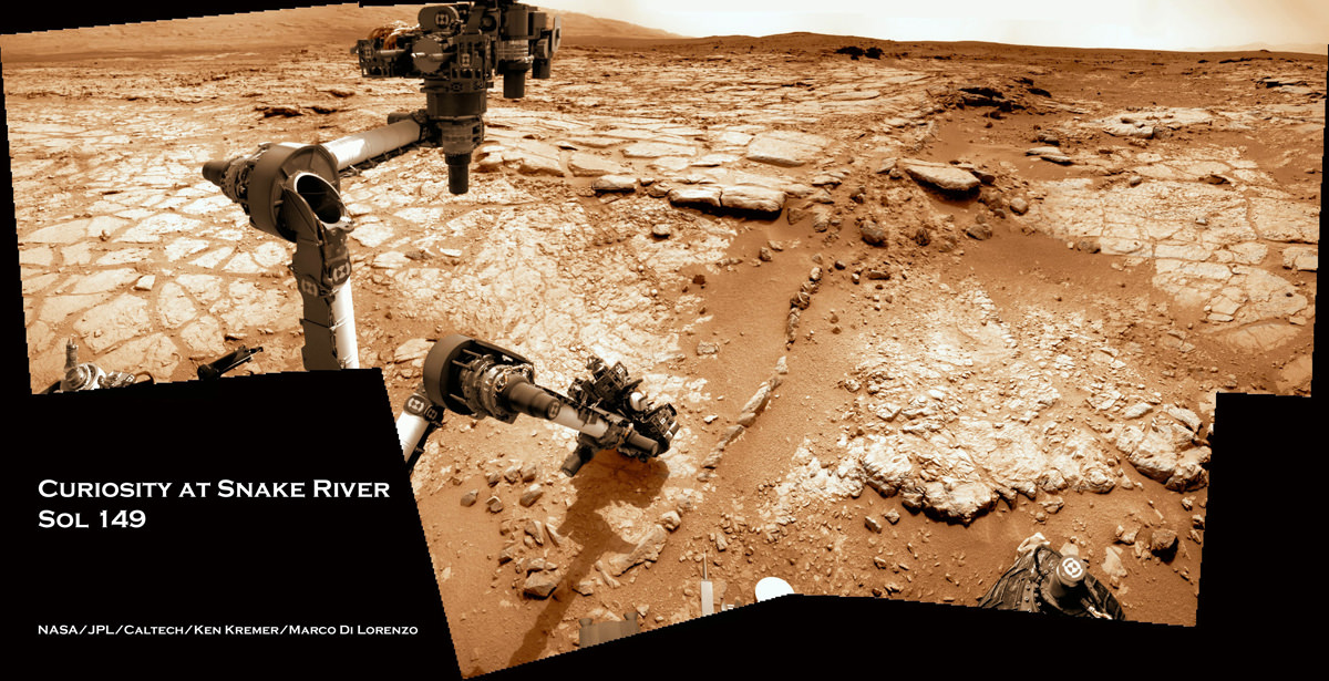
Image caption: Time lapse mosaic shows Curiosity rover’s arm movement from raised position to surface deployment on Sol 149 (Jan. 5) for contact science near the lower point of the slithery chain of narrow protruding rocks known as ‘Snake River’ – located inside the basin called “Yellowknife Bay’. The rover team will soon conduct historic first rock drilling in these surroindings. Curiosity has now driven to the larger, broken rock just above, right of the sinuous ‘Snake River’ rock formation. Photomosaic was stitched from Navcam raw images and is colorized with patches of sky added to fill in image gaps. Credit: NASA/JPL-Caltech/Ken Kremer/Marco Di Lorenzo

A team of Mars scientists and engineers have chosen the 1st rock drilling target for NASA’s Curiosity rover after carefully considering a range of options over the past several weeks at the robots current location inside a shallow depression known as ‘Yellowknife Bay’, which is replete with light toned rocks.

An official NASA announcement with further information is forthcoming on Tuesday this week, according to a source for this report.

Curiosity is now conducting a detailed science evaluation of the vicinity around a slithery chain of rocks called ‘Snake River’, jutting up from the sandy, rock strewn Martian floor – see our illustrative photo mosaics above & below and earlier story here.

Drilling goes to the heart of the mission and will mark a historic feat in planetary exploration – as the first time that an indigenous sample has been cored from the interior of a rock on another planet and subsequently analyzed by chemical spectrometers to determine its elemental composition and determine if organic molecules are present.

The first report of the drill target selection came just a day ago from Craig Covault at NASA Watch/Spaceref in an article, here – featuring our ‘Snake River’ time lapse mosaic (by Ken Kremer and Marco Di Lorenzo). The mosaic shows the arm in action deploying its science instruments and rotating to capture pictures with the MAHLI microscopic imager and contact science with the APXS mineral spectrometer.

The exact drilling spot has not been divulged but is likely near ‘Snake River’ and visible in our mosaics from Sol 149 and earlier Sols inside the ‘Yellowknife Bay’ basin – which exhibits cross bedding and is reminiscent of a dried up shoreline. Curiosity has now driven to the larger, broken rock just above, right of the sinuous ‘Snake River’ rock formation for up-close contact science investigations.

Curiosity 1st brushoff sol 150_1a_Ken Kremer

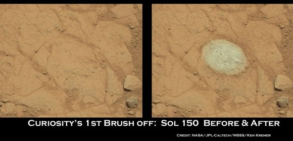
Image Caption: Before and after comparison of images of 1st ever rock brush off by Curiosity’s Dust Removal Tool (DRT) on Sol 150 (Jan 6, 2013), nearby to Snake River. Images taken by the high resolution Mastcam 100 camera, contrast enhanced. The brushed patch of rock target called “Ekwir_1” ‘is about 1.85 inches by 2.44 inches (47 millimeters by 62 millimeters). Credit: NASA/JPL-Caltech/MSSS/Ken Kremer

The Mars Science Lab (MSL) team is coordinating with top JPL & NASA management to get approval for the drilling location chosen or select another rock.

The high powered hammering drill is located on the tool turret at the end of the car-sized robots 7 foot (2.1 meter) long mechanical arm.

The percussive drill is the last component of Curiosity’s ten state-of-the-art science instruments that remains to be checked out and put into action.

Rock samples collected from the first test bore holes will be pulverized and the powdery mix will initially be used to rinse the interior chambers of the drill mechanisms and cleanse out residual earthly contaminants – and then dumped. The same procedure was carried out at the windblown ‘Rocknest’ ripple with the initial scoops of soil to cleanse the CHIMRA sample processing systems.

So it’s likely to take several weeks and possible a month or more until sieved samples are finally delivered to the CheMin and SAM analytical chemistry labs on the rover deck for analysis of their inorganic and organic chemical composition.

Curiosity touches Yellowknife Bay Sol 132_4c_Ken Kremer

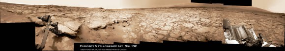
Image caption: Photo mosaic shows NASA’s Curiosity Mars rover reaching out to investigate rocks at a spot inside Yellowknife Bay on Sol 132, Dec 19, 2012. In search of first drilling target the rover drove to a spot at the right edge of this mosaic called Snake River rock. Curiosity’s navigation camera captured the scene surrounding the rover with the arm deployed and the APXS and MAHLI science instruments on tool turret collecting imaging and X-ray spectroscopic data. Base of Mount Sharp visible at right. The mosaic is colorized with patches of sky added to fill in gaps. Click to enlarge. Credit: NASA/JPL-Caltech/Ken Kremer/Marco Di Lorenzo

As a prelude on Sol 150 (Jan 6.), the rover successfully brushed off one of the flat rocks around Snake River for the first time by using the motorized, wire-bristle brush on the Dust Removal Tool (DRT), built by Honeybee Robotics of NYC.

The brushing was completed on a rock target called ‘Ekwir_1’ – see our mosaic showing a before and after comparison of rock surface images snapped by the Mastcam-100 high resolution color camera.

Brushing is a key step prior to rock drilling and allows the team to much more easily gain insight into the rocks composition with the science instruments compared to the obscured view of a dust blanketed rock. Spirit & Opportunity also have Honeybee Robotics built brushes that have still endured throughout their years’ long miraculous lifetimes.

The team then commanded the rover to bump a bit closer to “slightly younger rocks in front of the rover,” says MSL team member Ken Herkenhoff.

“The contact science activities in the current location went well, including the first brushing of the surface. In order to characterize the geology and chemistry of the rocks at the edge of Yellowknife Bay, we intend to repeat the set of brushing, APXS, MAHLI, ChemCam and Mastcam activities at the new location starting on Sol 152.”

“We are studying chemical and textural differences in the rocks near Snake River,” says Herkenhoff.

On Sol 152 (Jan. 8), Curiosity drove 2.5 meters closer to the area surrounding ‘Snake River’ and began snapping high resolution color imagery.

“It’s one piece of the puzzle,” says John Grotzinger, the mission’s chief scientist of the California Institute of Technology. “It has a crosscutting relationship to the surrounding rock and appears to have formed after the deposition of the layer that it transects.”

Grotzinger and the team are excited because Curiosity is a sort of time machine providing a glimpse into the Red Planets ancient history when the environment was warmer and wetter billions of years ago and much more conducive to the origin of life.

Ken Kremer

PIA16145

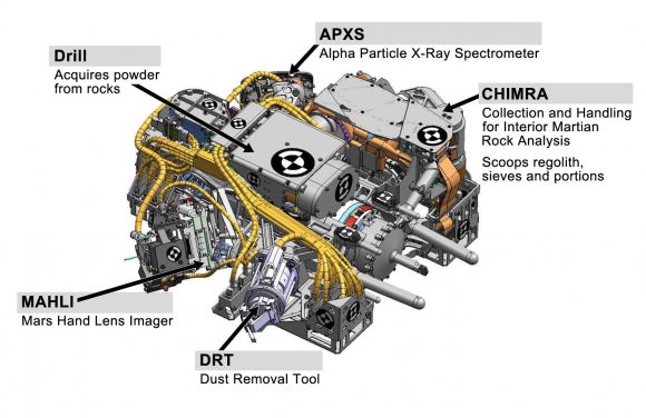
Image caption: Diagram shows all instruments on Tool turret on robotic arm. Credit: NASA