Watery Science ‘Jackpot’ Discovered by Curiosity

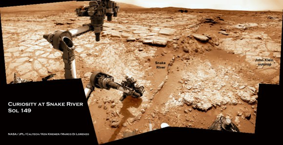
Curiosity found widespread evidence for flowing water in the highly diverse, rocky scenery shown in this photo mosaic from the edge of Yellowknife Bay on Sol 157 (Jan 14, 2013). The rover will soon conduct 1st Martian rock drilling operation at flat, light toned rocks at the outcrop called “John Klein”, at center. ‘John Klein’ drill site and ‘Sheep Bed’ outcrop ledges to right of rover arm are filled with numerous mineral veins and spherical concretions which strongly suggest precipitation of minerals from liquid water. ‘Snake River’ rock formation is the linear chain of rocks protruding up from the Martian sand near rover wheel. Credit: NASA/JPL-Caltech/Ken Kremer/Marco Di Lorenzo

The Curiosity rover hit the science “jackpot” and has discovered widespread further evidence of multiple episodes of liquid water flowing over ancient Mars billions of years ago when the planet was warmer and wetter, scientists announced. The watery evidence comes in the form of water bearing mineral veins, cross-bedded layering, nodules and spherical sedimentary concretions.

Any day now NASA’s mega robot will be instructed to drill directly into veined rocks where water once flowed, the team announced at a media briefing this week.

Delighted researchers said Curiosity surprisingly found lots of evidence for light-toned chains of linear mineral veins inside fractured rocks littering the highly diverse Martian terrain – using her array of ten state-of-the-art science instruments. Veins form when liquid water circulates through fractures and deposit minerals, gradually filling the insides of the fractured rocks over time.

Sometime in the next two weeks or so, NASA’s car sized rover will carry out history’s first ever drilling inside a Martian rock that was “percolated” by liquid water – an essential prerequisite for life as we know. A powdered sample will then be delivered to the robots duo of analytical chemistry labs (CheMin & SAM) to determine its elemental composition and ascertain whether organic molecules are present.

The drill target area is named “John Klein” outcrop, in tribute to a team member who was the deputy project manager for Curiosity at JPL for several years and who passed away in 2011.

“We identified a potential drill target and are preparing to do drill activities in the next two weeks. We are ready to go,” said Richard Cook, the project manager of NASA’s Jet Propulsion Laboratory (JPL) in Pasadena, Calif.

“Drilling [into a rock] is the most significant engineering activity since landing. It is the most difficult aspect of the surface mission, interacting with an unknown surface terrain, and has never been done on Mars. We will go slowly. It will take some time to deliver samples to CheMin and SAM and will be a great set of scientific measurements.”

pia16705annotated-br2

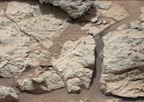
Image caption: Mineral veins of calcium sulfate discovered by Curiosity at ‘Sheepbed’ Outcrop. These veins form when water circulates through fractures, depositing minerals along the sides of the fracture, to form a vein. These vein fills are characteristic of the stratigraphically lowest unit in the “Yellowknife Bay” area where Curiosity is currently exploring and were imaged on Sol 126 (Dec. 13, 2012) by the telephoto Mastcam camera. Image has been white-balanced. Credit: NASA/JPL-Caltech/MSSS

“The scientists have been let into the candy store,” said Cook referring to the unexpected wealth of science targets surrounding the rover at this moment.

“There is a high diversity of rocks types here to characterize,” added Mike Malin, Mastcam principal investigator of Malin Space Science Systems (MSSS). “We see layering, veins and concretions. The area is still undergoing some changes.”

Curiosity is just a few meters away from ‘John Klein’ and will drive to the site shortly from her location inside ‘Yellowknife Bay’ beside the ‘Snake River’ rock formation. To see where Curiosity is in context with ‘John Klein’ and “Snake River’, see our annotated context mosaic (by Ken Kremer & Marco Di Lorenzo) as the rover collects data at a rock ledge.

The white colored veins were discovered over the past few weeks- using the high resolution mast- mounted imaging cameras and ChemCam laser firing spectrometer -at exactly the vicinity where Curiosity is currently investigating ; around a shallow basin called Yellowknife Bay and roughly a half mile away from the landing site inside Gale Crater.

“This lowest unit that we are at in Yellowknife Bay, the very farthest thing we drove to, turns out to be kind of the ‘jackpot’ unit here,” said John Grotzinger, the mission’s chief scientist of the California Institute of Technology. “It is literally shot through with these fractures and vein fills.”

pia16567-43[1]

Image caption: ‘John Klein’ Site Selected for Curiosity’s Drill Debut. This view shows the patch of veined, flat-lying rock selected as the first drilling site. The rover’s right Mast Camera equipped with a telephoto lens, was about 16 feet (5 meters) away from the site when it recorded this mosaic on sol 153 (Jan. 10, 2013). The area is shot full of fractures and veins, with the intervening rock also containing concretions, which are small spherical concentrations of minerals. Enlargement A shows a high concentration of ridge-like veins protruding above the surface. Some of the veins have two walls and an eroded interior. Enlargement B shows that in some portions of this feature, there is a horizontal discontinuity a few centimeters or inches beneath the surface. The discontinuity may be a bed, a fracture, or potentially a horizontal vein. Enlargement C shows a hole developed in the sand that overlies a fracture, implying infiltration of sand down into the fracture system. Image has been white-balanced. Credit: NASA/JPL-Caltech/MSSS

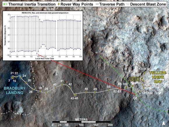
Shortly after landing the team took a calculated gamble and decided to take a several months long detour away from the main destination of the towering, sedimentary mountain named Mount Sharp, and instead drive to an area dubbed ‘Glenelg’ and home to ‘Yellowknife Bay’, because it sits at the junction of a trio of different geologic terrains. Glenelg exhibits high thermal inertia and helps put the entire region in better scientific context. The gamble has clearly payed off.

“We chose to go there because we saw something anomalous, but wouldn’t have predicted any of this from orbit,” said Grotzinger.

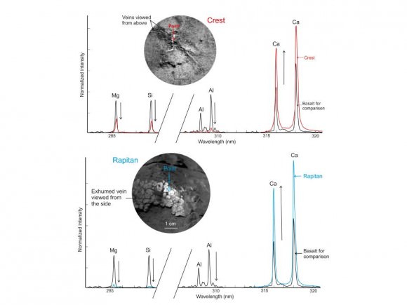
The Chemistry and Camera (ChemCam) instrument found elevated levels of calcium, sulfur and hydrogen. Hydrogen is indicative of water.

The mineral veins are probably comprised of calcium sulfate – which exists in several hydrated (water bearing) forms.

“The ChemCam spectra point to a composition very high in calcium. These veins are likely composed of hydrated calcium sulfate, such as bassinite or gypsum, depending on the hydration state,” said ChemCam team member Nicolas Mangold of the Laboratoire de Planétologie et Géodynamique de Nantes in France. “On Earth, forming veins like these requires water circulating in fractures and occur at low to moderate temperatures.”

The newly found veins appear quite similar to analogous veins discovered in late 2011 by NASA’s Opportunity rover – Curiosity’s older sister – inside Endeavour crater and nearly on the opposite side of Mars. See our Opportunity vein mosaic featured at APOD on Dec. 11, 2011 to learn more about veined rocks.

“What these vein fills tell us is water moved and percolated through these rocks, through these fracture networks and then minerals precipitated to form the white material which ChemCam has concluded is very likely a calcium sulfate, probably hydrated in origin,” Grotzinger explained.

“So this is the first time in this mission that we have seen something that is not just an aqueous environment, but one that also results in precipitation of minerals, which is very attractive to us.”

Yellowknife Bay and the ‘John Klein’ drilling area outcrop are chock full of mineral veins and sedimentary concretions.

“When you put all this together it says that basically these rocks were saturated with water. There may be several phases to this history of water, but that’s still to be worked out.”

“This has been really exciting and we can’t wait to start drilling,” Grotzinger emphasized.

Curiosity can drill about 2 inches (5 cm) into rocks. Ultimately a powdered sample about half an aspirin tablet in size will be delivered to SAM and CheMin after a few weeks. All rover systems and instruments are healthy, said Cook.

Grotzinger said that Curiosity will be instructed to drive over the veins to try and break them up and expose fresh surfaces for analysis. Then she will drill directly into a vein and hopefully catch some of the surrounding material as well.

“This will reveal the mineralogy of the vein filling material and how many hydrated mineral phases are present. The main goal is this will give us an assessment of the habitability of this environment.”

As the rover has driven down the shallow depression to deeper stratigraphic layers, the units are older in time.

After the first drill sample is fully analyzed, Grotzinger told me that the team will reevaluate whether to drill into a second rock.

The team doesn’t yet know whether the flowing water from which the veins precipitated was a more neutral pH or more acidic. “It’s too early to tell. We need to drill into the rock to tell and determine the mineralogy,” Grotzinger told me. Neutral water is more hospitable to life.

How long the episodes of water flowed is not yet known and it’s a complex history. But the water was at least hip to ankle deep at times and able to transport and round the gravel.

“There are a broad variety of sedimentary rocks here, transported from elsewhere. Mars was geologically active in this location, which is totally cool !,” said Aileen Yingst, MAHLI deputy principal investigator. ”There are a number of different transport mechanisms in play.”

719254main_pia16708-43_946-710

Image caption: Curiosity’s Traverse into Different Terrain. This image maps the traverse of NASA’s Mars rover Curiosity from “Bradbury Landing” to “Yellowknife Bay,” with an inset documenting a change in the ground’s thermal properties with arrival at a different type of terrain. credit: NASA/JPL-Caltech/Univ. of Arizona/CAB(CSIC-INTA)/FMI

Drilling goes to the heart of the mission and will mark a historic feat in planetary exploration – as the first time that an indigenous sample has been cored from the interior of a rock on another planet and subsequently analyzed by chemical spectrometers to determine its elemental composition and determine if organic molecules are present .

The high powered hammering drill is located on the tool turret at the end of the car-sized robots 7 foot (2.1 meter) long mechanical arm . It is the last of Curiosity’s ten instruments that remains to be checked out and put into action.

Curiosity landed on the Red Planet five months ago inside Gale Crater to investigate whether Mars ever offered an environment favorable for microbial life, past or present and is now nearly a quarter of the way through her two year prime mission.

Curiosity might reach the base of Mount Sharp by the end of 2013, which is about 6 miles (10 km) away as the Martian crow flies.

Ken Kremer

718888main_pia16615-43_946-710

Image Caption: Calcium-Rich Veins in Martian Rocks. This graphic shows close-ups of light-toned veins in rocks in the “Yellowknife Bay” area of Mars together with analyses of their composition. The top part of the image shows a close-up of the rock named “Crest,” taken by the remote micro-imager (RMI) on Curiosity’s Chemistry and Camera (ChemCam) instrument above the analysis of the elements detected by using ChemCam’s laser to zap the target. The spectral profile of Crest’s light-colored vein is shown in red, while that of a basaltic calibration target of known composition is shown in black. The bottom part of the image shows ChemCam’s close-up of the rock named “Rapitan” with the analysis of its elemental composition. The spectral profile of Rapitan’s light-colored vein is shown in blue, while that of a basaltic calibration target of known composition is shown in black. These results suggest the veins are unlike typical basaltic material. They are depleted in silica and composed of a calcium-bearing mineral. Credit: NASA/JPL-Caltech/LANL/CNES/IRAP/LPGNantes/CNRS

Curiosity at Snake River Sol 149_5Aa_drill target_Ken Kremer

Image caption: Curiosity will carry out 1st rock drilling at ‘John Klein’ outcrop visible in this time lapse mosaic showing movements of Curiosity rover’s arm on Sol 149 (Jan. 5, 2013) at Yellowknife Bay basin where the rover has found widespread evidence for flowing water. Curiosity discovered hydrated mineral veins and concretions around the rock ledge ahead . She next drove there for contact science near the slithery chain of narrow protruding rocks known as ‘Snake River. Photomosaic stitched from Navcam raw images and colorized. Credit: NASA/JPL-Caltech/Ken Kremer/Marco Di Lorenzo

MSL Update: Curiosity Finds Calcium-Rich Deposits

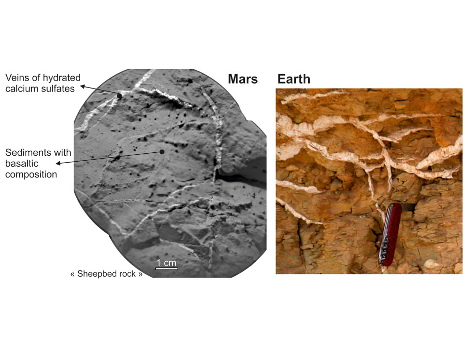
Veins in Rocks on Mars and Earth. Ccredit: NASA/JPL-Caltech/LANL/CNES/IRAP/LPGNantes/CNRS/LGLyon/Planet-Terre

Justin Maki, the Engineering Camera Team Lead for the Mars Science Laboratory provides the latest Curiosity Rover Report from JPL and talks about how the rover has found calcium deposits on Mars similar to those seen on Earth when water circulates in cracks and rock fractures.

The set of images below shows the similarity of sulfate-rich veins seen on Curiosity rover to sulfate-rich veins seen on Earth. The view on the left is a mosaic of two shots from the remote micro-imager on Curiosity’s Chemistry and Camera (ChemCam) instrument on Dec. 14, 2012, or the 126th sol, or Martian day, of operations. They show a view of “Sheepbed” rock in the “Yellowknife Bay” area of Mars. The sulfate-rich veins are the light-colored veins about 1 to 5 millimeters (0.04 to 0.2 inches) wide.

The image on the right is from the Egyptian desert on Earth. A pocket knife is shown for scale. (image courtesy of Pierre Thomas).

Astronomy Photographer of the Year Competition Now Open for 2013

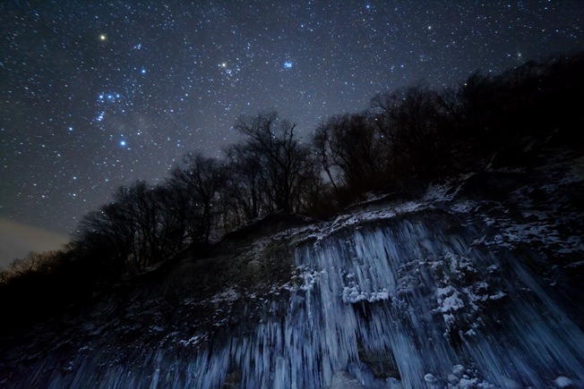
Winning photograph in the Earth and Space category in the 2012 Astronomy Photographer of the Year Competition, 'Star Icefall' by Masahiro Miyasaka (Japan).

It’s back! The 2013 Astronomy Photographer of the Year competition is now open and accepting submissions. This is the fifth year of the competition, which is is run by the Royal Observatory Greenwich in association with Sky at Night Magazine. Every year it produces some of the most beautiful and spectacular visions of the cosmos, whether they are striking pictures of vast galaxies millions of light years away, or dramatic images of the night sky taken much closer to home.

“Every year brings something new to see in the sky and the arrival in March of the predicted Comet C/2011 PANSTARRS will hopefully inspire some memorable pictures in this year’s competition,” said Dr. Marek Kukula, Public Astronomer at the ROG and judge in the competition. “It will be great to see even more entries from talented young photographers and newcomers to astrophotography who prove year after year that all you need to do is pick up a camera.”

Entries to the competition must be submitted by June 13, 2013. There are some great prizes, too. The overall winner will receive £1,500. Category winners will receive £500. There are also prizes for runners-up (£250) and highly commended (£125) entries. The Special Prize winners will receive £350, with an £125 prize for the People and Space Special Prize runner-up. All of the winning entries will receive a one year subscription to Sky at Night Magazine.

Astronomy Photographer of the Year 2013 has four main categories:

Earth and Space – Photographs that include landscape, people and other earth-related things alongside an astronomical subject ranging from the stars, the Moon or near-Earth phenomena such as the aurora.

Our Solar System – Imagery which captures the Sun and its family of planets, moons, asteroids and comets.

Deep Space – Pictures that capture anything beyond the Solar System, including stars, nebulae and galaxies.

Young Astronomy Photographer of the Year – Pictures taken by budding astronomers under the age of 16 years old.

There are also three special prizes: People and Space recognizes the best photo featuring people in the shot; Best Newcomer is awarded to the best photo by an amateur astrophotographer who has taken up the hobby in the last year and who has not entered an image into the competition before; and Robotic Scope, is awarded for the best photo taken using one of the increasing number of computer-controlled telescopes at prime observing sites around the world which can be accessed over the internet by members of the public.

The winning images will be showcased in the annual free exhibition at the Royal Observatory Greenwich from September 19, 2013 to February 23, 2014.

Find more info and enter online by visiting www.rmg.co.uk/astrophoto . Each entrant may submit up to five images to the competition.

To view the entries submitted so far, visit www.flickr.com/groups/astrophoto

So get out there with your camera! And good luck!

Gorgeous Images: Ancient River on Mars?

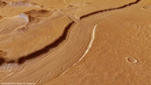
Perspective view of Reull Vallis. ESA’s Mars Express imaged the striking upper part of the Reull Vallis region of Mars with its high-resolution stereo camera last year. Reull Vallis, the river-like structure in these images, is believed to have formed when running water flowed in the distant martian past, cutting a steep-sided channel through the Promethei Terra Highlands before running on towards the floor of the vast Hellas basin. Credit and Copyright: ESA/DLR/FU Berlin (G. Neukum)

The Mars Express has long been taking pictures of what appears to be an ancient riverbed on Mars. In fact, Reull Vallis was one of the first objects on the Red Planet that Mars Express ever imaged back in 2004 when the spacecraft arrived in orbit. The latest images show the sinuous river-like feature that stretches for nearly 1,500 km across the Martian landscape. This winding depression is 6-10 km wide, and its depth varies from 100-600 meters. In comparison, the Amazon River on Earth is about 6,500 km long and 11 km wide in places.

So, is this really an ancient river?

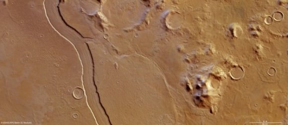
High-Resolution Stereo Camera image of Reul Vallis taken on May 14, 2012 by ESA’s Mars Express. Credit:  ESA/DLR/FU Berlin (G. Neukum)
High-Resolution Stereo Camera image of Reul Vallis taken on May 14, 2012 by ESA’s Mars Express. Credit: ESA/DLR/FU Berlin (G. Neukum)

Planetary scientists seem to be fairly unanimous that, from orbit, this appears to be a riverbed. There is a system of tributaries and side channels that all appear to flow into the huge Hellas Basin.

There are various theories as to how it may have formed, however. Some scientists say that this feature may have been created quickly in a sudden deluge or runoff event, as the entire system look like stream beds cut by sudden runoff in desert regions on the Earth.

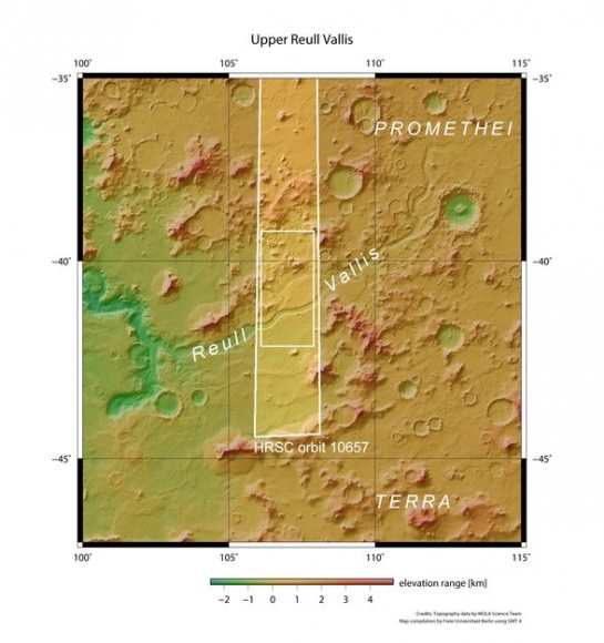
Reull Vallis in context. Credit: NASA MGS MOLA Science Team.

Others suggest this system consists of parts that were formed during several phases rather than being a single continuous channel, and likely had independent formation phases and different sources of water. For example, numerous crescent-shaped features could be older craters distorted by water flow.

There is also evidence of deposits of volatiles in the walls of the channel that could be ice.

In the wider context image above, the tributary intersecting the main channel appears to be part of a forking of the main valley into two distinct branches further upstream before merging back into a single main valley.

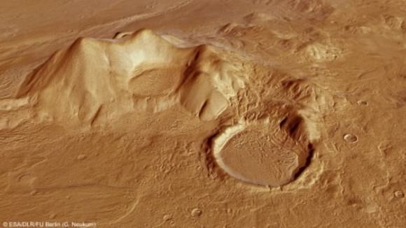
The right (northern) part of the main image is dominated by the Promethei Terra Highlands with their high and soft-rounded mountains shown in these images, rising around 2500 m above the surrounding flat plains.

The perspective view below shows one of these mountains with nearby sediment-filled impact craters:

This computer-generated perspective view shows part of the Promethei Terra highlands adjacent to Reull Vallis. Credit: ESA/DLR/FU Berlin (G. Neukum) >
This computer-generated perspective view shows part of the Promethei Terra highlands adjacent to Reull Vallis. Credit: ESA/DLR/FU Berlin (G. Neukum)

What about lava flow? Could this be a giant lava flow or tube that has collapsed? Astronomers say that lava and glacial erosion would have produced very different channels.

And so it appears Reull Vallis provides evidence of past water on Mars. And if so, it means that the planet’s climate has changed dramatically since these features were formed between 3.5 billion and 1.8 billion years ago.

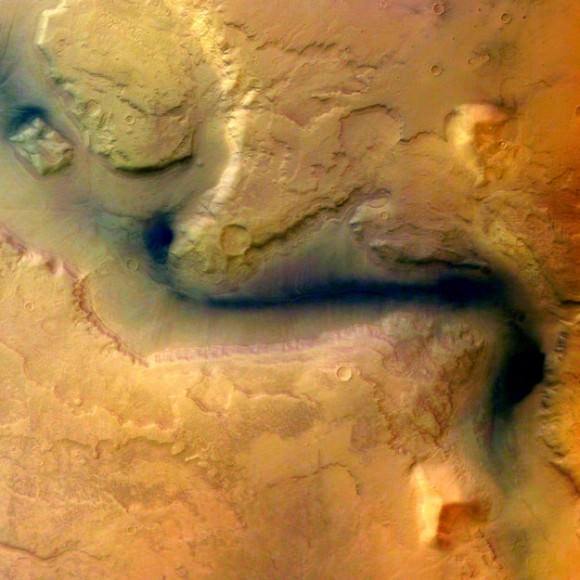
One of the first images taken by Mars Express in 2004 of Reull Vallis. Credit: Credit: ESA/DLR/FU Berlin (G. Neukum)

Sources: ESA Science paper from 1997 by Scott Mest and David Crown, University of Pittsburgh, Paper by Kostama, et al, 2007, ESA 2004.

The Secrets of Moondogs

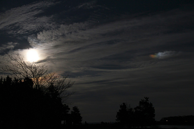
A Moondog, captured over Hampton Bays, New York in December 2011. Credit: Jeff Schultz

[/caption]

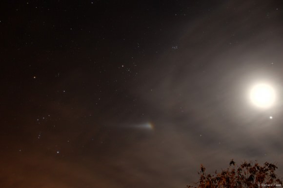
You’ve probably heard of — and likely have even seen — a Sundog, the atmospheric phenomenon that creates rainbow-colored blobs or arcs of light on either side of the Sun. But did you know the Moon can have ‘dogs’ too? Also known as mock moons, false moons, or the scientific name of paraselenae, Moondogs aren’t seen as often as Sundogs. However, the conditions needed to create either of the ‘dogs’ are about the same. This great image of a Moondog, above, by Jeff Schultz is a perfect example of the kind of night you might see this gorgeous phenomenon.

What are the secrets to how Moondogs are produced?

A bright Moondog on January 20, 2012 seen in Wiltshire, England. Credit and copyright: Richard Fleet. Used by permission.
A bright Moondog on January 20, 2012 seen in Wiltshire, England. Credit: Richard Fleet

Moondogs are seen most often in the winter when ice crystals may be present in the atmosphere. But they can appear anytime of the year when hexagon-shaped ice crystals might be high in the sky, or also when thin cirrus or cirrostratus clouds are just right. What happens is that the ice crystals or clouds refract the moonlight, creating blobs or arcs of light to the left and right of the Moon, or sometimes just on one side.

Also, the Moon usually needs to be full or nearly full, along with being low in the sky for the effect to be produced. The angular separation of the light blobs from the Moon is usually 22 degrees.

Sometimes, a full halo of light around the Moon will also appear in conjunction with the Moondogs; other times smaller arcs of light will be part of the effect, but often Moondogs appear without any other effects.

Moondogs can appear colorful like a Sundog or ‘shine’ with a light similar to the Moon.

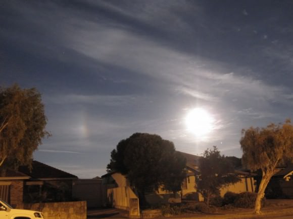
A Moondog seen in Adelaide, Australia on November 28, 2012. Credit: Ian Musgrave.
A Moondog seen over Adelaide, Australia on November 28, 2012. Credit: Ian Musgrave.

Moondogs are seen in both hemispheres, as this image from Ian Musgrave in Australia attests, but it seems that the effect is seen most often the farther north you are in the northern hemisphere and the farther south you are in the southern hemisphere.

You never know exactly when you might be lucky enough to see a Moondog, so we recommend looking at the Moon every night! Also, don’t forget to wink at the Moon, too.

For more detailed information and images of Moondogs, Sundogs and other optical effects, Richard Fleet (the photographer who captured the second image in this article) has a great website: “Glows, Bows and Haloes.”

Our Phases of the Moon App is Now a Lunar Atlas

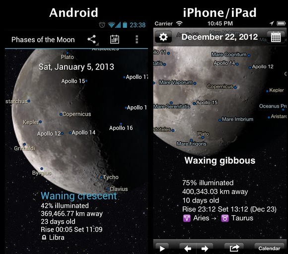
We’ve done a major update to our Phases of the Moon app for iPhone/iPad and Android, finally fulfilling the most requested feature: a Lunar Atlas.

You can now pinch-zoom the Moon and two-finger pan it around. As you zoom the Moon beyond a certain size, labels for lunar features will appear, like major craters, Apollo landing sites and lunar seas (mare). As you zoom in more, smaller features become visible. Now that we’ve figured out how to actually implement this functionality, we’ll keep improving it, to make Phases of the Moon a really handy tool for stargazing, especially when you’re using a telescope.

There are lots of other features we’ve recently added including: total lunar eclipses, Live Wallpaper and Widgets (for Android), social sharing, and more.

You can download the iPhone/iPad version here.

Or you can access the Android version here.

Either app costs only $.99 and helps support the costs of Universe Today.

P.S. If you’ve already got either app, please take a second and give us a review on iTunes or Google Play. Every little bit helps.

NASA’s Lunar Orbiter Gets an Art Lesson with Lasers

In the ultimate example of science imitating art, engineers working with NASA’s Lunar Reconnaissance Orbiter recently beamed an image of the Mona Lisa to the LRO and back via laser beam in order to measure the rate of transmission between the spacecraft and Earth. This allowed them to then calibrate their software to correct for any discrepancies between the image sent and the one received, resulting in a picture-perfect result.

Leonardo would definitely have approved.

From NASA’s Goddard Space Flight Center:

As part of the first demonstration of laser communication with a satellite at the moon, scientists with NASA’s Lunar Reconnaissance Orbiter (LRO) beamed an image of the Mona Lisa to the spacecraft from Earth.

The iconic image traveled nearly 240,000 miles in digital form from the Next Generation Satellite Laser Ranging (NGSLR) Station at NASA’s Goddard Space Flight Center in Greenbelt, MD, to the Lunar Orbiter Laser Altimeter (LOLA) instrument on the spacecraft. By transmitting the image piggyback on laser pulses that are routinely sent to track LOLA’s position, the team achieved simultaneous laser communication and tracking.

“This test, and the data obtained from it, sets the stage for future high data-rate laser communications demonstrations that will be an essential feature of NASA’s next Moon mission: the Lunar Atmosphere and Dust Environment Explorer.

Video: NASA/GSFC

Region in LMC Ablaze with Light and Color

Nearly 200 000 light-years from Earth, the Large Magellanic Cloud, a satellite galaxy of the Milky Way, floats in space, in a long and slow dance around our galaxy. As the Milky Way’s gravity gently tugs on its neighbour’s gas clouds, they collapse to form new stars. In turn, these light up the gas clouds in a kaleidoscope of colours, visible in this image from the NASA/ESA Hubble Space Telescope.

Hubble view of star formation region N11 from the NASA/ESA Hubble Space Telescope. Image credit: NASA/ESA Hubble. Zoom by John Williams/TerraZoom using Zoomify.

New computer wallpaper alert. Light from the Large Magellanic Cloud takes nearly 200,000 years to travel to Earth. And it’s worth the wait.

Behold LHA 120-N 11, or just simply N11, in this image from the NASA/ESA Hubble Space Telescope.

Continue reading “Region in LMC Ablaze with Light and Color”

Stunning Timelapse of Earth and Sky — Volume 3

I’ve been waiting for this! We’ve featured previous timelapse videos by Dustin Farrell, and here is part three of his “Landscapes” video series showing stunning views of Earth and sky. This is really gorgeous. Watching in HD with a big screen is recommended.

On Vimeo, Dustin writes that this is the final volume in this series, at least for a while. “I hope you have enjoyed my work on this series over the last three years,” he wrote. “It has been an amazing ride full of amazing experiences. I plan to continue shooting landscapes timelapses but putting together videos of this magnitude will be difficult to continue on a regular basis.”

Sounds like maybe he’s moving on to bigger and better things, and he’s also got a new website where his new work will be showcased.
Continue reading “Stunning Timelapse of Earth and Sky — Volume 3”