NASA Looks Towards Next Mission to the Moon

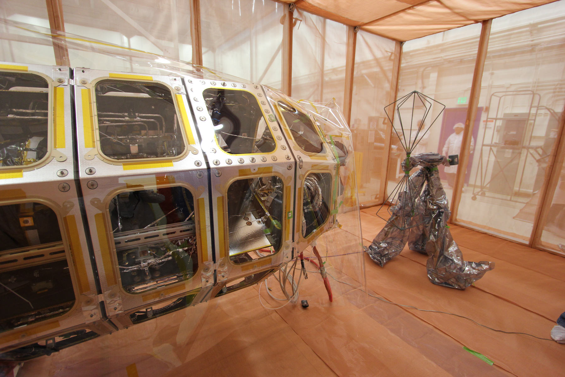
NASA’s Lunar Atmosphere and Dust Environment Explorer (LADEE) Observatory sits beside a radio frequency antenna inside an enclosure that blocks external static to detect electromagnetic emissions. Image credit: NASA Ames

With the GRAIL mission ending today, NASA is preparing for its next lunar orbiter mission, which could help pave the way for a potential future human mission to the Moon. While the Moon seems to be an ‘on-again-off-again’ potential human destination, as the GRAIL mission points out, studies of our closest neighbor in space continues to reveal surprises.

But if we are ever going to establish any sort of long-term presence on the Moon, scientists and engineers will have to understand more about the environmental conditions that they’re dealing with. Lunar dust is an environmental factor that requires much more exploration and study, as it may pose one of the biggest problems for humans on the Moon. Lunar dust is as fine as talcum powder and abrasive enough to cause long term problems to the lenses and seals central to the operation of mechanical equipment — not to mention hazards to human health — during any lengthy stay on the Moon.

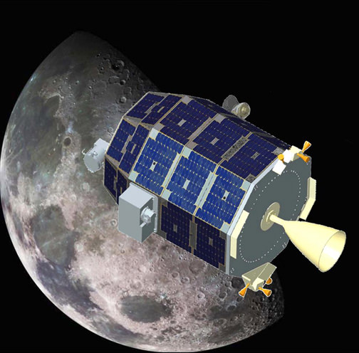
Artist concept of the LADEE spacecraft in orbit at the Moon. Credit: NASA

To study this unique lunar environmental phenomenon, NASA is in the process of testing the Lunar Atmosphere and Dust Environment Explorer (LADEE) in preparations for its upcoming launch. Recently, LADEE integrated the last of its three main science instruments. The three instruments to be launched with the craft are the Ultraviolet and Visible Light Spectrometer, which will analyze the light signatures of the materials it detects on the Moon, the Neutral Mass Spectrometer, set to detect differences in what little atmosphere there is on the Moon over multiple orbits, and the Lunar Dust Experiment, which will collect and analyze any dust particles that are floating around the sparse atmosphere that LADEE will be flying in.

In addition to it’s science experiments, LADEE will be technically unique in a few ways. First, it is pioneering NASA’s Modular Common Bus architecture, which will hopefully increase the compatibility between future lunar spacecraft’s communications and power systems and thereby decrease their cost.

LADEE will also carry a “technology demonstration payload,” which will allow it to communicate with Earth using lasers rather than radio waves. This will dramatically increase the speed of information transfer between the spacecraft and its controllers, resulting in almost broadband-internet levels of data exchange. If this technology proves successful it is likely to be used on future lunar exploration missions as well.

LADEE is currently undergoing a battery of environmental tests. Acoustic, vibration, shock and thermal-vacuum test still await the spacecraft after it recently passed the electromagnetic interference test. Assuming it manages to keep its clean bill of health, the spacecraft could be launched on it’s 160 day mission as early as August 2013. With its help, humanity will have a better understanding of how to combat one of the most unfriendly aspects of the lunar environment.

More information on LADEE from NASA

Curiosity Inspects ‘Shaler’ Outcrop on Descent to Yellowknife Bay Drill Target – 2D/3D

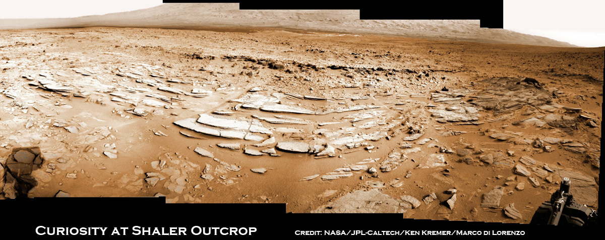
Image caption: Sol 120 colorized panorama of big and stunning ‘Shaler’ layered rock outcrop snapped by Curiosity’s right eye Navigation Camera (Navcam) on Dec. 7, 2012. ‘Shaler’ exhibits a pattern geologists refer to as ‘crossbedding’, at angles to one another. Some of the larger individual plates are about a foot or more wide. The cropped view spans from north at left to south at right. Future destination Mount Sharp is visible in the background. See the full 2-D panorama below and compare with the stereo effect available from NASA’s 3-D panorama, below. Credit: NASA/JPL-Caltech/Ken Kremer/Marco Di Lorenzo

NASA’s Curiosity rover is on the final steps of her descent into a geologist’s paradise at an area called ‘Yellowknife Bay’.

Along the way just days ago on Sol 120 (Dec 7, 2012) she stopped to inspect a huge outcrop of layered rocks dubbed ‘Shaler’ and snapped dozens of high resolution photos with the Navcam and Mastcam cameras.

To catch a human’s eye view of the breathtaking terrain of what some might hearken to an ‘unexpected journey’, check out our Sol 120 photo mosaic in 2-D (above) and then compare that with NASA’s 3-D photo mosaic (below). You will need to whip out you red-cyan anaglyph glasses to take in the full measure of Curiosity’s glorious surroundings and the foreboding shadow – can you guess what that is?

The ‘Shaler’ outcrop features a plethora of striking layers, angled to each other in a pattern geologists refer to as ‘crossbedding’.

The team also used Curiosity’s Chemistry and Camera (ChemCam) instrument on the rover’s mast to help assess the content of ‘Shaler.’

With the Christmas holidays fast approaching, the rover science team is searching for a suitable location at Yellowknife Bay to select as the first potential target to drill into with Curiosity’s advanced percussion drill.

Thereafter she will deliver powdered rock samples to the CheMin and SAM duo of miniaturized analytical chemistry labs on the rovers deck to elucidate the inorganic mineral composition as well as seek to determine if any organic molecules are present.

Image caption: Complete Sol 120 colorized panorama of big ‘Shaler’ layered rock outcrop snapped by Curiosity’s right eye Navigation Camera (Navcam) on Dec. 7, 2012. ‘Shaler’ exhibits a pattern geologists refer to as ‘crossbedding’, at angles to one another. The view spans from north-northwest at the left to south-southwest at the right. Study this full 2-D panorama and compare with the stereo effect available from NASA’s 3-D panorama, below. Credit: NASA/JPL-Caltech/Ken Kremer/Marco Di Lorenzo

Image caption: Sol 120 Stereo panorama of ‘Shaler’ rock outcrop snapped by the right and left eye Navigation Camera (Navcam) on Dec. 7, 2012. The view spans from north-northwest at the left to south-southwest at the right, and is presented in a cylindrical-perspective projection. Credit: NASA/JPL-Caltech

Yellowknife Bay lies within the place dubbed ‘Glenelg’, the rovers first major science destination. Glenelg uniquely sits at the junction of three different types of intersecting geologic features that will help unravel the mysteries of Curiosity’s Gale Crater touchdown zone beside a humongous mountain known as Mount Sharp – the main target of the mission.

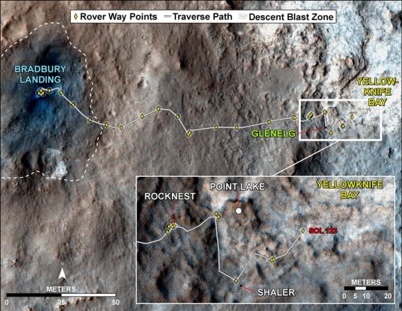
After safely surviving the harrowing touchdown at ‘Bradbury Landing’ on Aug. 6, the SUV-sized Curiosity rover has been on a roll to reach the inviting interior terrain of ‘Glenelg’ before Christmas.

The six wheeled robot has thus far traversed more than 0.37 mile (598 meters) and is now driving on top of the most challenging and scientifically rewarding terrain of the entire four month journey.

“The rover is traversing across terrain different from where it has driven earlier, and responding differently,” said Rick Welch, mission manager at NASA’s Jet Propulsion Laboratory, Pasadena, Calif. “We’re making progress, though we’re still in the learning phase with this rover, going a little slower on this terrain than we might wish we could.”

Curiosity will spend at least several weeks thoroughly investigating Yellowknife Bay before reversing course and setting out on the year-long 6 mile (10 km) trek to the lower reaches of Mount Sharp. Along the way, the science team may possibly choose to re-investigate the Shaler and Hottah outcrops with the rover’s suite of 10 state-of-the-art science instruments.

Ken Kremer

Image caption: Curiosity Traverse Map, Sol 123 (Dec. 10, 2012). This map traces where NASA’s Mars rover Curiosity drove between landing at a site named ‘Bradbury Landing,’ and the position reached during the mission’s 123rd Martian day, or sol, (Dec. 10, 2012) at ‘Yellowknife Bay’ inside the place called ‘Glenelg’. Credit: NASA/JPL-Caltech/Univ. of Arizona

Incredible Sky Show: Geminid Meteor Shower Images from Around the World

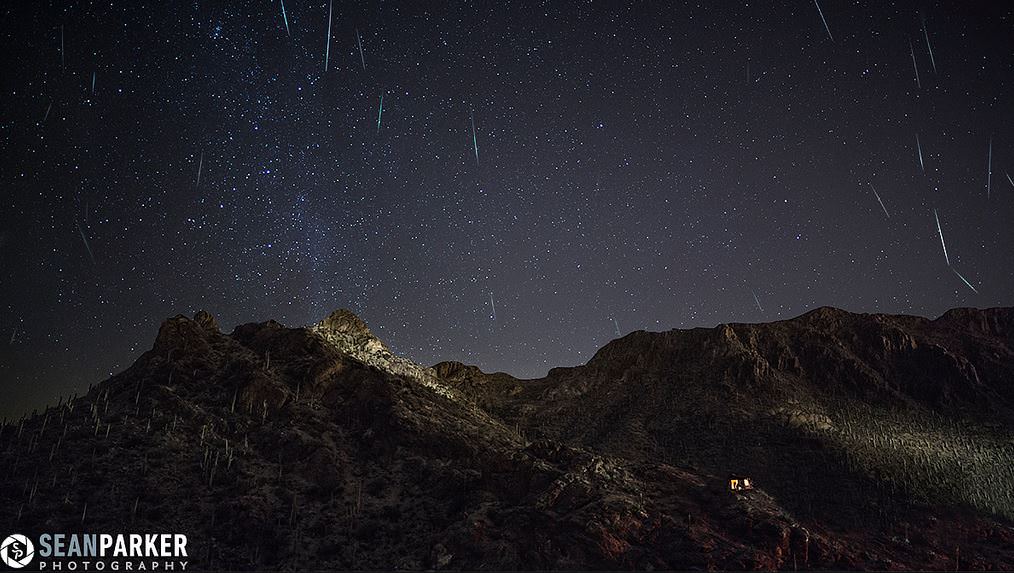
Geminids at Gates Pass. Composite image from 30 frames of video. Credit: Sean Parker

The 2012 Geminid Meteor Shower has lived up to expectations, and here are some images and videos provided by people around the world.

“What an incredible show we had here!” said Sean Parker in Tucson, Arizona, USA. “I was able to see about 50 per hour.”

The images were shot at Gates Pass in Tucson, Arizona on the morning of 12-13-12. You can see M31 (Andromeda Galaxy 2.5 million light years away) at the left next to the Milky way.

More below, and you can click on most of these images to see larger versions in Flickr or Twitter.

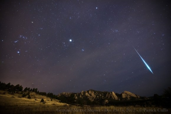
Geminid Fireball. A large Geminid burns up in the atmosphere above the iconic Flatirons of Boulder, CO. Credit: Patrick Cullis

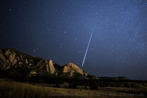
And another by Patrick:

Geminid Meteor Shower above the Flatirons, Boulder, CO. Credit: Patrick Cullis

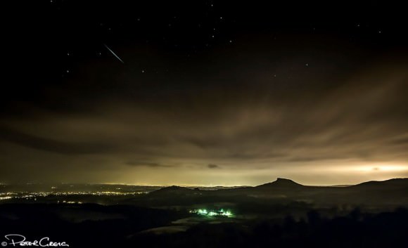
Raining Down on Roseberry Topping (Geminid Meteor Shower 2012).Credit: Peter Greig.

Peter says: “This is the only meteor I caught whilst on a Geminid meteor hunting trip …at Captain Cooks Monument, Great Ayton, North Yorkshire, UK.”

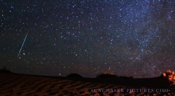
Geminid Meteor Over Death Valley. Credit: Gavin Heffernan/SunChaser Pictures

Meteors in Malta. Credit: Leonard Ellul-Mercer

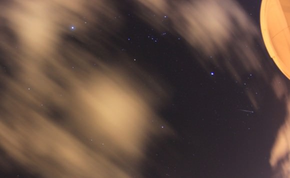
Leonard shares: “Last night the sky was totally overcast in Malta and this was very depressing as I was looking forward to this meteor shower. At around midnight I decided to retire, However, before doing so I went on the roof and noted some very small breaks in the cloud, but in a matter of 10 minutes I noted 6 bright meteors in these small gaps. So I presumed that there was a good meteor shower going on beyond those clouds. After about 30 mins. the cloud break increased and the show started off. It was a great meteor shower with bright meteors appearing every one or two minutes.”

Here’s a compilation of various views from a news station in Modesto, California. Some shots are obviously from a fish-eye camera:

Want to get your astrophoto featured on Universe Today? Join our Flickr group or send us your images by email (this means you’re giving us permission to post them). Please explain what’s in the picture, when you took it, the equipment you used, etc.

Asteroid Toutatis Tumbles in New Video from NASA

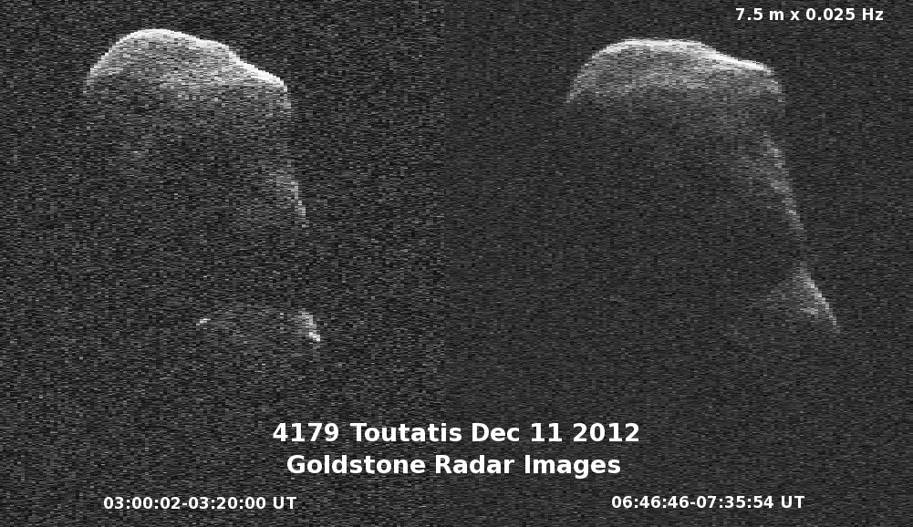
NASA has compiled the radar images taken of Asteroid Toutatis during its flyby of Earth this week to create a short movie, which shows the asteroid slowly tumbling. The 64-frame movie was generated from data gathered on December 12 and 13, 2012 by NASA’s 70-meter Goldstone Deep Space Network antenna in Goldstone, California.

NASA provides more information about the video and (4179) Toutatis:

On Dec. 12, the day of its closest approach to Earth, Toutatis was about 18 lunar distances, 4.3 million miles (6.9 million kilometers) from Earth. On Dec. 13, the asteroid was about 4.4 million miles (7 million kilometers), or about 18.2 lunar distances.

The radar data images of asteroid Toutatis indicate that it is an elongated, irregularly shaped object with ridges and perhaps craters. Along with shape detail, scientists are also seeing some interesting bright glints that could be surface boulders. Toutatis has a very slow, tumbling rotational state. The asteroid rotates about its long axis every 5.4 days and precesses (changes the orientation of its rotational axis) like a wobbling, badly thrown football, every 7.4 days.

The orbit of Toutatis is well understood. The next time Toutatis will approach at least this close to Earth is in November of 2069, when the asteroid will safely fly by at about 7.7 lunar distances, or 1.8 million miles (3 million kilometers). An analysis indicates there is zero possibility of an Earth impact over the entire interval over which its motion can be accurately computed, which is about the next four centuries.

This radar data imagery will help scientists improve their understanding of the asteroid’s spin state, which will also help them understand its interior.

The resolution in the image frames is 12 feet (3.75 meters) per pixel.

Source: NASA

Apollo’s Final Footsteps, 40 years later

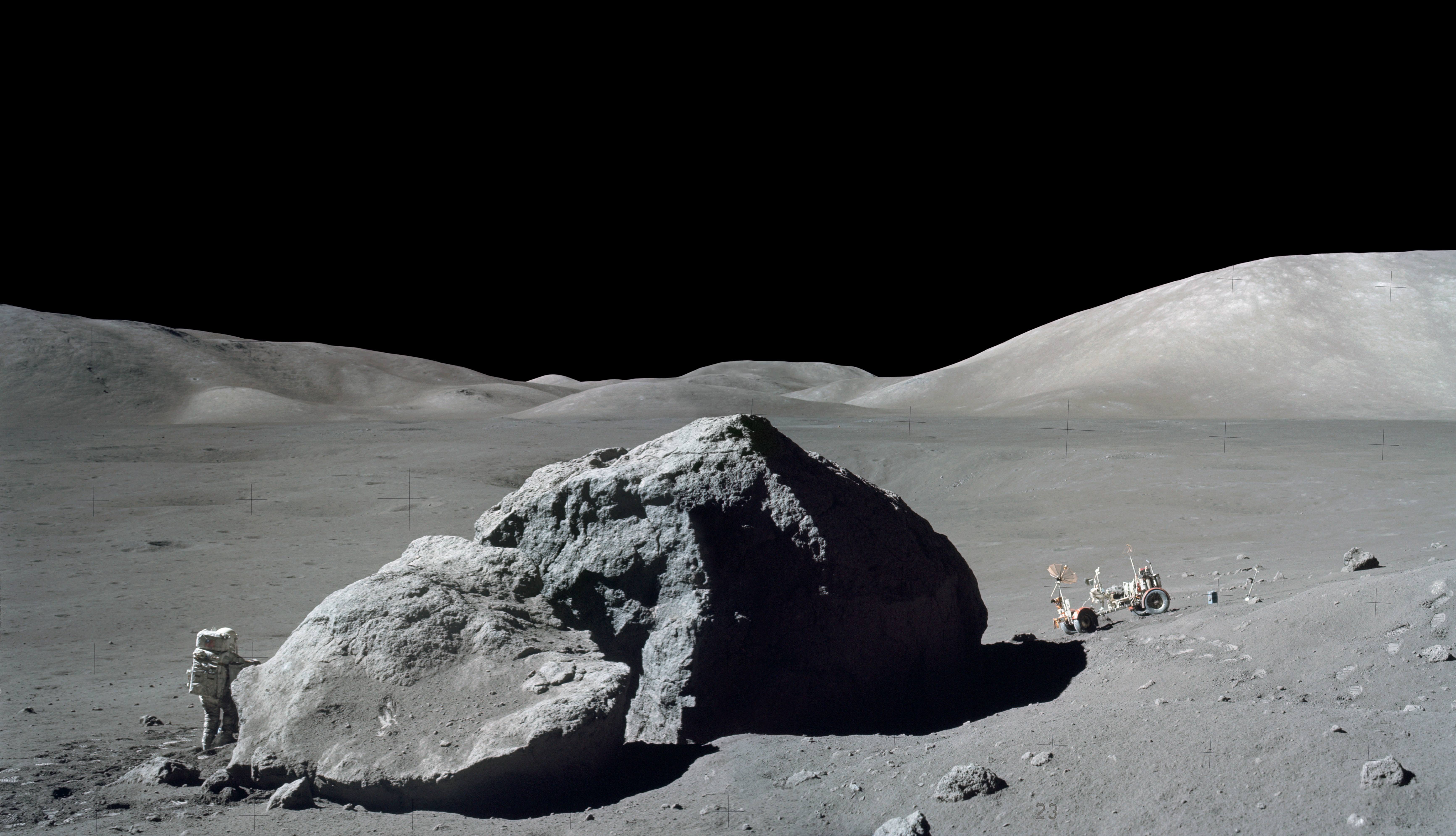
Image Credit: NASA/Eugene Cernan

Will there come a time when we on Earth can look up at the Moon and know that people are living there permanently?

40 years ago today, humans left the Moon for the last time during our visits during the Apollo program. Author Andrew Chaikin has been creating a series of videos on why space exploration is important, and to mark the 40th anniversary of the last human footsteps on the moon, he looks back at Apollo 17’s explorations and explains why he believes the Moon is the solar system’s “jewel in the crown,” beckoning us to return.


“The Moon is an ideal place for future astronauts to tackle the enormous challenges of living on other worlds,” Chaikin says, “a kind of outward-bound school for learning to live off-planet that is just three days away from home.”

You can see all of Chaikin’s videos here, and here’s an interview we did with Chaikin last year, “Was the Apollo Program an Anomaly?

Additionally, read a great article the Amy Shira Teitel wrote for us last year about the Apollo 17 mission’s last Moonwalk.

[/caption]

Endgame: GRAIL Spacecraft to Slam into Lunar Crater Rim on December 17

The GRAIL mission will come to a dramatic end on Monday as the two spacecraft will be commanded to crash into the rim of an unnamed crater near the Moon’s north pole. This is all according to plan, as the two spacecraft are running out of fuel after being in lunar orbit since New Year’s Day 2012.

“We successfully completed our primary science mission,” said Principal Investigator Maria Zuber, “ and, frankly, in my wildest dreams I don’t think this mission could have gone any better than it has. But when you orbit a planetary body that has lumpy gravity field, you use a lot of fuel.”

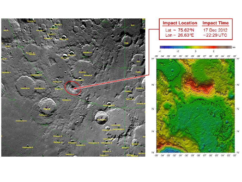
On Dec. 17 at about 5:28 EST, the spacecraft dubbed Ebb will undergo a controlled impact into a 2 km high “mountain, a rim of a crater that has been buried in ejecta near north pole of the Moon (coordinates are 75.62°N, 26.63°W). About 30 seconds later Flow will impact, about 40 km apart.

Both spacecraft will hit the surface at 3,760 mph (1.7 kilometers per second). No imagery of the impact is expected because the region will be in shadow at the time.

These maps of Earth’s moon highlight the region where the twin spacecraft of NASA’s Gravity Recovery and Interior Laboratory (GRAIL) mission will impact on Dec. Image credit: NASA/GSFC

Additionally, Gruber said that while they hope the Lunar Reconnaissance Orbiter will be able to observe the impact region (at the very least image the region both before and after impact), they don’t expect to there to be a “flash” visible from Earth, and do not believe there will be a significant chance of doing science by kicking up volatiles like LCROSS did, mostly because of the GRAIL spacecraft small size (each about the size of a washing machine) and because of the low angle of impact. The spacecraft have been at a low orbit averaging about 11 km above the surface this week, to be able to map at a high resolution before the fuel ran out.

They chose a mountain-side “since we’re coming in at angle of 1.5 degrees, it would only have left “skid marks” on level surface,” Zuber said. “There was interest in the team in impacting a structure, or a wall, so we could learn about mechanical properties of a crater rim. We’ll be looking at the rim of the crater and understanding how much is intact rock and how much is broken up. It will be very low probability but high scientific payoff if it works, if any volatiles they would be liberated from the impacts.”

The twist on this observation, Zuber said, is this crater is in sunlight most of the time, so if any volatiles come out, it would be surprising.

GRAIL project manager David Lehman said that Friday morning (December 14) the spacecraft will each be executing a maneuver will targeting the impact site, that will also position them to avoid what are called “historic heritage sites,” where the US and Russians have put soft landers on the Moon.

Then they’ll turn off the science instruments, followed by a series of engineering demonstrations to help with future missions over the weekend. About 54 minutes before impact, they’ll burn the remaining fuel to complete the last maneuver.

Lehman said there is a bit of challenge in hitting the crater rim. “We need to clear a ridge and then keep from going through a gap in the rim, because otherwise it would keep going and hit the far side of the Moon.”

Lehman added he was sad to see the mission end. “I’m kind of hoping tonight that a gas station will pull up to our spacecraft and refuel it.”

During their prime mission, from March through May, Ebb and Flow collected data while orbiting at an average altitude of 34 miles (55 kilometers). Their altitude was lowered to 14 miles (23 kilometers) for their extended mission, which began Aug. 30 and sometimes placed them within a few miles of the moon’s tallest surface features.

The duo’s successful prime and extended science missions generated the highest-resolution gravity field map of any celestial body. The map will provide a better understanding of how Earth and other rocky planets in the solar system formed and evolved.

“It is going to be difficult to say goodbye,” said Zuber. “Our little robotic twins have been exemplary members of the GRAIL family, and planetary science has advanced in a major way because of their contributions.”

Podcast: Explosions in Space

We’ve all seen the classic science fiction space explosions, full of flames and loud sounds. Beautiful on the screen but, totally lacking in any kind of… science. What’s wrong with science fiction? What would chemical and nuclear explosions really look like? What would we hear? And what are some natural explosions that nature detonates in space?

Click here to download the episode.

Or subscribe to: astronomycast.com/podcast.xml with your podcatching software.

“Explosions in Space” on the Astronomy Cast website, with shownotes and transcript.

And the podcast is also available as a video, as Fraser and Pamela now record Astronomy Cast as part of a Google+ Hangout:

Geminid Meteor Shower Peaks Tonight

Winter Milky Way Geminids on December 12, 2012. Credit: John Chumack

The Geminid Meteor Shower is underway, with the peak on December 13th and 14th! SpaceWeather.com is reporting that international observers are counting as many as 50 meteors per hour as Earth plunges into a stream of debris from rock comet 3200 Phaethon. Astrophotographer John Chumack in Ohio, USA took the image of a bright fireball last night (Dec. 12/13) and said he was seeing one or two meteors every minute or so, describing the sky show as “definitely one of the best Geminid showers I’ve seen in over 20 years!”

John also compiled a video, below.

So if you’ve got clear skies, get out there and look up! The best time to look will be after dark on Thursday, December 13 and before dawn on Friday, December 14. The Geminids are notably one of the most reliable meteor showers, and this year the timing is great as the new Moon won’t intefer with the shower. Astronomers from McDonald Observatory at the University of Texas predicts skywatchers can expect to see dozens of meteors per hour.


Additionally, NASA says that for the first time, Earth might also pass through the tail of another object, comet Wirtanen, which could possibly provide even more meteors in the sky. No one is really sure what kind of meteor action this comet will produce, but Bill Cooke of NASA’s Meteoroid Environment off says even if the new shower is a dud, the Geminids should be great.

For the Geminids, meteors will appear to originate from the constellation Gemini, although they should be visible all over the sky. If Wirtanen does contribute to the shower, they may appear to come from the constellation Pisces.

If you’ve got cloudy skies or its too cold outside, there are a few alternatives:

NASA TV is going to have a live broadcast from 11:00 pm-3:00 am EST.

You can follow along via Twitter and MeteorWatch. All you need to do is check for the #meteorwatch hashtag, and people will be posting descriptions and images.

You can also “listen” to the meteor shower: The Air Force Space Surveillance Radar is scanning the skies above Texas. When a meteor or satellite passes over the facility–ping!–there is an echo. Check out SpaceWeatherRadio for the broadcast.

Combining Light to Reveal Monster Black Holes

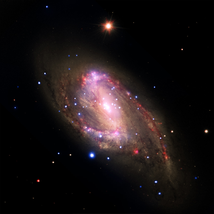
NGC 3627 glows in the combined light of Hubble, Chandra, Spitzer and the Very Large Telescope in this image. Astronomers conducted a survey of 62 galaxies, including NGC 3627 to study monster black holes at their centers.

It’s not just pretty, it’s science. Like a starry watercolor, astronomers combining light from Earth and space-based observatories found 37 new supermassive black hole candidates lurking in nearby galaxies.

Included in that survey is NGC 3627 pictured above. Astronomers combined X-ray data from NASA’s Chandra X-ray Observatory, infrared data from the Spitzer Space Telescope, and optical data from the Hubble Space Telescope and the Very Large Telescope. The other images give the galaxy context but it’s the ghostly blue images from Chandra that show super bright in the X-ray images; X-ray light powered by material falling into a monster black hole.

Gas and dust slowly spins around the black hole creating a flattened disk, or accretion disk. As material falls inward, it heats up and releases large amounts of energy that shine brightly in the ultraviolet region of the spectrum.

NGC 3627, located about 30 million light-years from Earth, was just one of a survey of 62 nearby galaxies using archived data from Chandra and data from the Spitzer Infrared Nearby Galaxy Survey. Of those, 37 galaxies contained bright X-ray sources, indicating active black holes at their cores. Scientists believe that seven of those sources are new supermassive black hole candidates.

The paper describing the survey results was published in the April 10, 2011 issue of The Astrophysical Journal.

Combining ultraviolet and infrared observations confirm previous Chandra results that found that there may be many more galaxies powered by monster black holes than believed previously through optical surveys. Scientists say in the paper that low-levels of black hole activity previously may have been hidden by dust or washed out by the bright light of the galaxy.

Image caption: Bright X-ray sources glow a ghostly blue in this image in NGC 3627 from NASA’s Chandra X-ray Observatory. A study confirms previous Chandra results that indicate that more galaxies powered by monster black holes populate the cosmos.

Source: Chandra X-ray Observatory website

One Spacecraft Captures Another in Lunar Orbit

moon.thumbnail.gif

This is awesome! It is the first footage of one orbiting robotic spacecraft taken by another orbiting robotic spacecraft at Earth’s moon. “Flow,” one of two satellites making up NASA’s Gravity Recovery and Interior Laboratory (GRAIL) mission, captured this video of NASA’s Lunar Reconnaissance Orbiter (LRO) as it flew by at a distance of about 20 kilometers (12 miles) on May 3, 2012. LRO is the single bright pixel that moves from top left to bottom right. The Moon’s south polar region is in the background, much of which is in darkness.

This footage was taken by Flow’s “MoonKam” camera, which is an educational camera run by the GRAIL team and Sally Ride Science.