Peekaboo Sun: SDO’s Eclipse Season

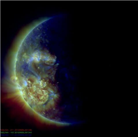
Now you see it, now you don’t! Around the solstices, the Solar Dynamics Observatory ends up having an “eclipse season,” where the Sun, Earth, and the SDO line up, and some of the images and video sent down from the spacecraft appear as though the Sun disappears for a while or just part of the Sun is visible. This is a normal part of life with a geosynchronous observatory, the SDO team says.

They explain it this way:

“Twice a year, SDO enters an eclipse season where the spacecraft slips behind Earth for up to 72 minutes a day. Unlike the crisp shadow one sees on the sun during a lunar eclipse, Earth’s shadow has a variegated edge due to its atmosphere, which blocks the sun light to different degrees depending on its density. Also, light from brighter spots on the sun may make it through, which is why some solar features extend low into Earth’s shadow.”

There’s no way to avoid the loss of images, but the continuous contact with the ground station SDO’s orbit allows was judged to outweigh the loss of some images.

This eclipse season started September 6, and it ends tomorrow, on September 29, 2012, so see it while you can!

A River Ran Through It: Why Do They Think There Was Once Water on Mars?

Why is everyone so excited about these dusty Mars rocks?

This week’s big news was the announcement of evidence for flowing water on Mars, based on images of what appear to be smooth river rock-type pebbles found by Curiosity. Of course that’s a big statement to make, and for good reason — identifying water, whether present or past, is one step closer to determining whether Mars was ever a suitable place for life to develop. Yet here we are, not even two months into the mission and Curiosity is already sending us solid clues that Mars was once a much wetter place than it is now.

JPL released a video today providing a brief-but-informative overview of what Curiosity has discovered in Gale Crater and why it’s gotten everyone so excited.

Check it out so you’ll have something to talk about over the weekend:

MSL Long Term Planner Sanjeev Gupta reviews Curiosity’s latest discovery

Video: JPLNews. Images: NASA/JPL-Caltech

Weekly Space Hangout – Sept. 27, 2012

This was an action-packed episode of the Weekly Space Hangout. Lots of stories, very little time.

Participants: Mike Wall, Alan Boyle, Ian O’Neill, Nancy Atkinson, Jason Major

Host: Fraser Cain

Want to watch us record the show live? Point your browser at next week’s event page to put the recording right into your calendar.

Astrophoto: The Crescent Nebula & Wolf Rayet Star by John Chumack

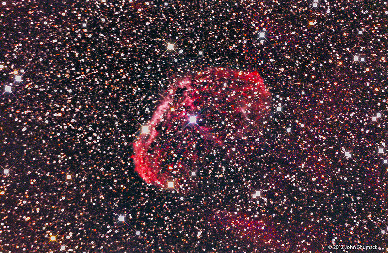
NGC6888 The Crescent Nebula & Wolf Rayet Star (WR136). Credit: John Chumack.

Here’s an impressive shot of NGC 6888, also known as the Crescent Nebula, which is a cosmic bubble about 25 light-years across. It is part of the massive Gamma Cygni Nebula region, and in the center is a powerful, bright and massive Wolf-Rayet star. “The very energetic Wolf-Rayet star is shedding its outer envelope in a strong stellar wind, ejecting the equivalent of the Sun’s mass every 10,000 years,” explains prolific and talented astrophotographer John Chumack. “This cosmic bubble is located in this very rich star studded field, which is about 3,000 light years away.”

To capture this image, John used a QHY8 cooled Color CCD Camera and his homemade 16″ Newtonian Scope, with a 90 minute exposure, taken on August 24, 2012 at his observatory in Yellow Springs, Ohio. See more of his work at his website, Galactic Images.

Want to get your astrophoto featured on Universe Today? Join our Flickr group or send us your images by email (this means you’re giving us permission to post them). Please explain what’s in the picture, when you took it, the equipment you used, etc.

Parallax Effect Charted in the 2012 Transit of Venus

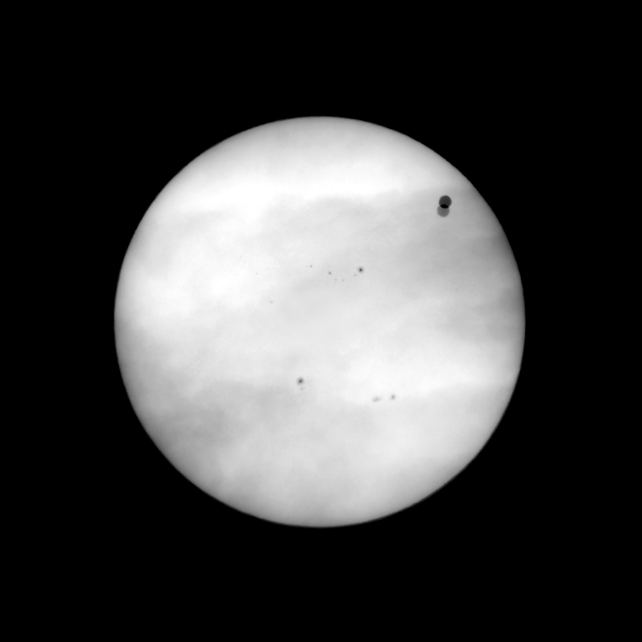
Combined images taken simultaneously (06 June 2012, 03:46:18 UTC) from Svalbard and Canberra, showing the Venus parallax effect from 2 different locations on Earth, separated by 11600km. Credit: Pérez Ayúcar/Breitfellner

Back in the 18th century, astronomers were trying to determine the distance from the Earth to the Sun. They used the parallax method during the Transits of Venus the 1760s to help answer that question, and their results provided a cosmic measuring stick that has allowed astronomers to measure distances in the Universe.

How did that method work? New images and movies of the transit of Venus on June 6, 2012 which compare event from two different locations on Earth clearly show the parallax effects that have made Venus transits so important historically.


The movies compress 6 hours of observations and 5,000 individual images taken by optical and solar telescopes into a 40 second video. Data gaps due to cloudy conditions produce jumps in the otherwise smooth Venus motion across the Sun disk. The observations were taken from Svalbard in Norway and Canberra in Australia, which are separated by 11,600 km (7,200 miles).

When the images from the two locations are compared, the parallax effect is obvious.

By knowing the distance between two observers on Earth and comparing the differences in their observations, astronomers were able to work out the distance from the Earth to Venus. And because of Johannes Kepler’s calculations, 18th century astronomers already knew Venus’ orbit is about 70 percent that of Earth’s. So by knowing the distance between the Earth and Venus, they were also able to figure out the value for the Astronomical Unit.

The images used in the movies were obtained by members of the European Space Astronomy Centre, which is located outside Madrid. Two of the observers, Miguel Pérez Ayúcar and Michel Breitfellner are on the science operations planning team for the Venus Express satellite, which has been orbiting Venus since 2006.

“During the hours of the transit we were delighted by the slow, delicate, gracious passage of Venus in front of the Sun,” Ayúcar said. “A perfect black circle, containing a world in it, moving in front of its looming parent star. How thankful we were to witness it. Now with these movies, we can share a sense of that experience.”

Breitfellner said, “In the 18th century people realized that transits of Venus could be used to measure the distance from the Earth to the Sun. Teams of astronomers were sent all across the world to measure this effect. The 2012 transit has its own historical importance – it is the first that has occurred when a spacecraft is in orbit at Venus. Science teams are now working to compare observations of the Venus transit from Earth with simultaneous observations from Venus Express.”

Colin Wilson, Operations Scientist for Venus Express, said, “Planetary transits are not just of historical interest, they have acquired a new importance in the study of newly discovered planets around other stars. Because we cannot image exoplanets directly, it is only by studying their transits that we can discover whether they harbour liquid water or other potential ‘biomarker’ molecules like methane or ozone. The Venus transit is an example much closer to home, offering us a chance to test our understanding of how to interpret transit data. This certainly added extra interest as we watched the Venus transit in June – particularly knowing it was our last chance that we’d have to wait until 2117 to see the next one!”

Transit of Venus 2012 from Svalbard and Canberra from Lightcurve Films on Vimeo.

Source: EPSC

Vesta’s Deep Grooves Could Be “Stretch Marks” From Impact

Dawn image of Vesta showing its nearly circumferential equatorial grooves (NASA/JPL-Caltech/UCLA/MPS/DLR/IDA)

Even though NASA’s Dawn spacecraft has departed Vesta the trove of data it’s gathered about this fascinating little world continues to fuel new discoveries. Most recently, some researchers are suggesting that Vesta’s curious grooves — long, deep troughs that wrap around its equator, noticed immediately after Dawn came within close proximity — are actually features called graben, the results of surface expansion along fault lines.

In Vesta’s case, the faults likely may have come from whatever major collision created the enormous central peak that rises almost three times the height of Mt. Everest from its south pole… and the expansion could be the result of differentiation of its interior — a separation of core, mantle and crust that’s much more planet-like than anything asteroidish.


On smaller asteroids and moons, stress fractures tend to have a “V” shape, cutting inwards to a sharp point. But the troughs on Vesta are more rounded, with a “U” shape that results from surface material slumping downwards as the surface pulls apart. Found on larger worlds like Earth, the Moon, Mars, Mercury — and now possibly Vesta as well — graben are shaped by motions below the crust and not just the splitting of the surface.

The biggest of Vesta’s troughs, Divalia Fossa, is 465 kilometers (289 miles) long, 22 km (13.6 mi) wide and 5 km (3 mi) deep… longer and three times deeper than the Grand Canyon.

Animation of Vesta rotating made from Dawn images and assembled by The Planetary Society’s Emily Lakdawalla

If the researchers are correct and these are indeed graben, rather than just fractures or grooves carved into the surface by another process, Vesta probably had a lot more going on inside it than does your typical asteroid.

“By saying it’s differentiated, we’re basically saying Vesta was a little planet trying to happen,” said Debra Buczkowski of the Johns Hopkins University Applied Physics Laboratory (JHUAPL), lead author of a new paper titled “Large-scale troughs on Vesta: A signature of planetary tectonics” scheduled to be published by the AGU on Sept. 29.

Read more: Is Vesta a Planet Among Asteroids?

Unlike its big sister Ceres, the largest world among the asteroids and Dawn’s next destination, Vesta isn’t officially classified as a dwarf planet because its shape isn’t spherical enough — a flagrant violation of IAU Planetary Code Regulation No. 2. Rather it’s more flattened, like a walnut. This of course is also likely the result of the impact Vesta sustained at its south pole (which also may be responsible for its rapid 5.35-hour rotation rate, helping to bulge out the equatorial region and possibly even provide an alternate source for the trough “stretch marks”) and so begs the question, was Vesta once a dwarf planet? And if so, does severe reconstruction by an impact event “reclassify” it as something else? What, then? Ex-dwarf planet? A planet-formerly-known-as-dwarf?An undwarf?

I’m sure the IAU is already anticipating the contretemps.

“We have been calling Vesta the smallest terrestrial planet. The latest imagery provides much justification for our expectations. They show that a variety of processes were once at work on the surface of Vesta and provide extensive evidence for Vesta’s planetary aspirations.”

– Chris Russell, Dawn mission principal investigator at UCLA

Read more on the American Geophysical Union’s press release here, and follow the latest from NASA’s Dawn mission here.

Curiosity Finds Evidence of An Ancient Streambed on Mars

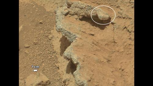
NASA’s Curiosity rover found evidence for an ancient, flowing stream on Mars at a few sites, including the rock outcrop pictured here, which the science team has named “Hottah” after Hottah Lake in Canada’s Northwest Territories. Credit: NASA/JPL/Caltech

The Curiosity rover has come across a place in Gale Crater where ankle-to-hip-deep water once vigorously flowed: an ancient streambed containing evidence of gravel that has been worn by water. At a press briefing today, members of the Mars Science Laboratory team said the rover has found “surprising” outcrops and gravel near the rover landing site that indicate water once flowed in this region, and likely flowed for a long time.

“Too many things that point away from a single burst event,” said Curiosity science co-investigator William Dietrich of the University of California, Berkeley. “I’m comfortable to argue that it is beyond the 1,000 year timescales, even though this is very early on in our findings.”
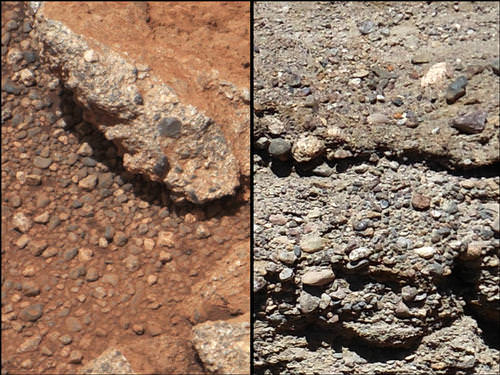
This set of images compares the Link outcrop of rocks on Mars (left) with similar rocks seen on Earth (right). Credit: NASA/JPL/Caltech

From the size of gravel found by the rover, the science team can interpret the water was moving about 1 meter (3 feet) per second, with a depth somewhere between ankle and hip deep.

“Plenty of papers have been written about channels on Mars with many different hypotheses about the flows in them,” said Dietrich. “This is the first time we’re actually seeing water-transported gravel on Mars. This is a transition from speculation about the size of streambed material to direct observation of it.”

What Curiosity found on Mars was described as conglomerate rock made up of water-transported gravels, meaning the gravel is now cemented into a layers of rock, and the sizes and shapes of stones offer clues to the speed and distance of a long-ago stream’s flow.

“The shapes tell you they were transported and the sizes tell you they couldn’t be transported by wind. They were transported by water flow,” said Curiosity science co-investigator Rebecca Williams of the Planetary Science Institute.

The discovery comes from examining two outcrops, called “Hottah” and “Link,” with the telephoto capability of Curiosity’s mast camera during the first 40 days after landing. Those observations followed up on earlier hints from another outcrop, named Goulburn, which was exposed by thruster exhaust as Curiosity touched down.

“Hottah looks like someone jack-hammered up a slab of city sidewalk, but it’s really a tilted block of an ancient streambed,” said Mars Science Laboratory Project Scientist John Grotzinger of the California Institute of Technology.
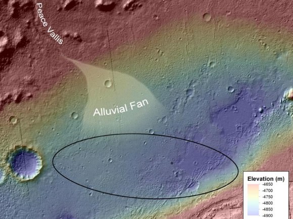
An alluvial fan, or fan-shaped deposit where debris spreads out downslope are usually formed by water, and new observations from Curiosity of rounded pebbles embedded with rocky outcrops provide concrete evidence that water did flow in this region on Mars. Elevation data were obtained from stereo processing of images from the High Resolution Imaging Science Experiment (HiRISE) camera on NASA’s Mars Reconnaissance Orbiter. Image credit: NASA/JPL-Caltech/UofA

Even though the team classified the finding as “surprising,” they later said they actually weren’t too surprised at what they found so early in the mission – just 51 sols, or Martian days, in.

“We are getting better about integrating the orbital data,” said Grotzinger. “We see an alluvial fan and debris flow from orbit, and then see these water-transported pebbles from the ground. This is not rocket science, but shows exactly the reason we chose this landing site, and you build on those foundations you think you are mostly likely to establish. Now we’ll look at more rocks and get more context to recreate the environment in greater detail along with understanding the chemistry of the time to see if this is a place that could be habitable.”

Asked if it was hard to come to consensus on this long-term, quickly flowing water statement, given the large number of scientists involved with the mission, Grotziner said, “Given the evidence we have from orbit that has been analyzed, when we arrive with a robot we can test the hypothesis pretty quickly. If the geological signal for this process is large enough, it is easy to achieve a consensus pretty quickly.”

The finding site lies between the north rim of Gale Crater and the base of Aeolis Mons, or Mount Sharp, a mountain inside the crater. To the north of the crater, a channel named Peace Vallis feeds into the alluvial fan. The abundance of channels in the fan between the rim and conglomerate suggests flows continued or repeated over a long time, not just once or for a few years, the science team said.

But interestingly, the rover has already moved on from this spot, and yesterday took the longest drive yet, of between 52-53 meters, heading towards the Glenelg region where they want to do their first scooping and tests soil samples in Curiosity’s two instruments, SAM (Sample Analysis at Mars) and ChemMin (Chemistry & Mineralogy X-Ray Diffraction/X-Ray Fluorescence Instrument). These two experiments will study powdered rock and soil samples scooped up by the robotic arm.

The Glenelg area marks the intersection of three kinds of terrain: bedrock for drilling, several small craters that may represent an older or harder surface, and also terrain similar to where Curiosity landed, so the science team can do comparisons.

“A long-flowing stream can be a habitable environment,” said Grotzinger. “But it is not our top choice as there might be other places that have preserved organic carbon better than this, and we need to assess the potential for preservation of organics. We’re still going to Mount Sharp, but this is insurance that we have already found our first potentially habitable environment.”

The slope of Aeolis Mons contains clay and sulfate minerals, which have been detected from orbit. This can be good preservers of carbon-based organic chemicals that are potential ingredients for life.

As for what’s next for Curiosity, Grotzinger said they have a couple of targets in the next 2-4 sols, and then they will park for a long period of time, about 2-3 weeks to prepare for reaching Glenelg. “This is such a complex set of processes that have never been done on Mars before, so we are going to be conservative and go slowly to make sure everything is working as it should. Then we’ll go to Glenelg and choose first candidate for drilling.”
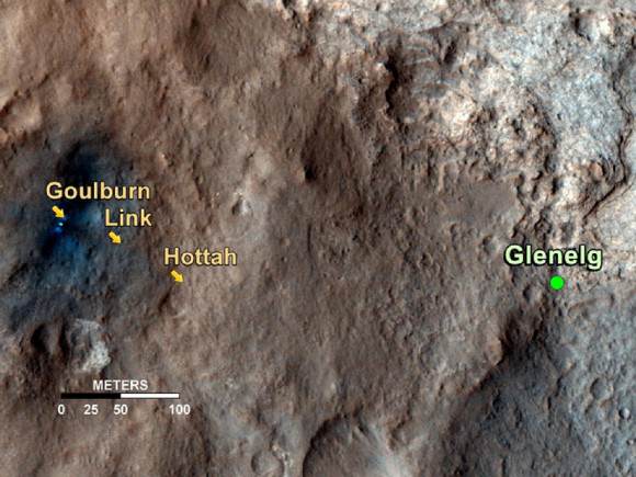
This map shows the path on Mars of NASA’s Curiosity rover toward Glenelg. Credit: NASA/JPL/Caltech/University of Arizona

Sources: Press briefing, NASA press release

Amateur Astronomer Creates Detailed Map of Ganymede

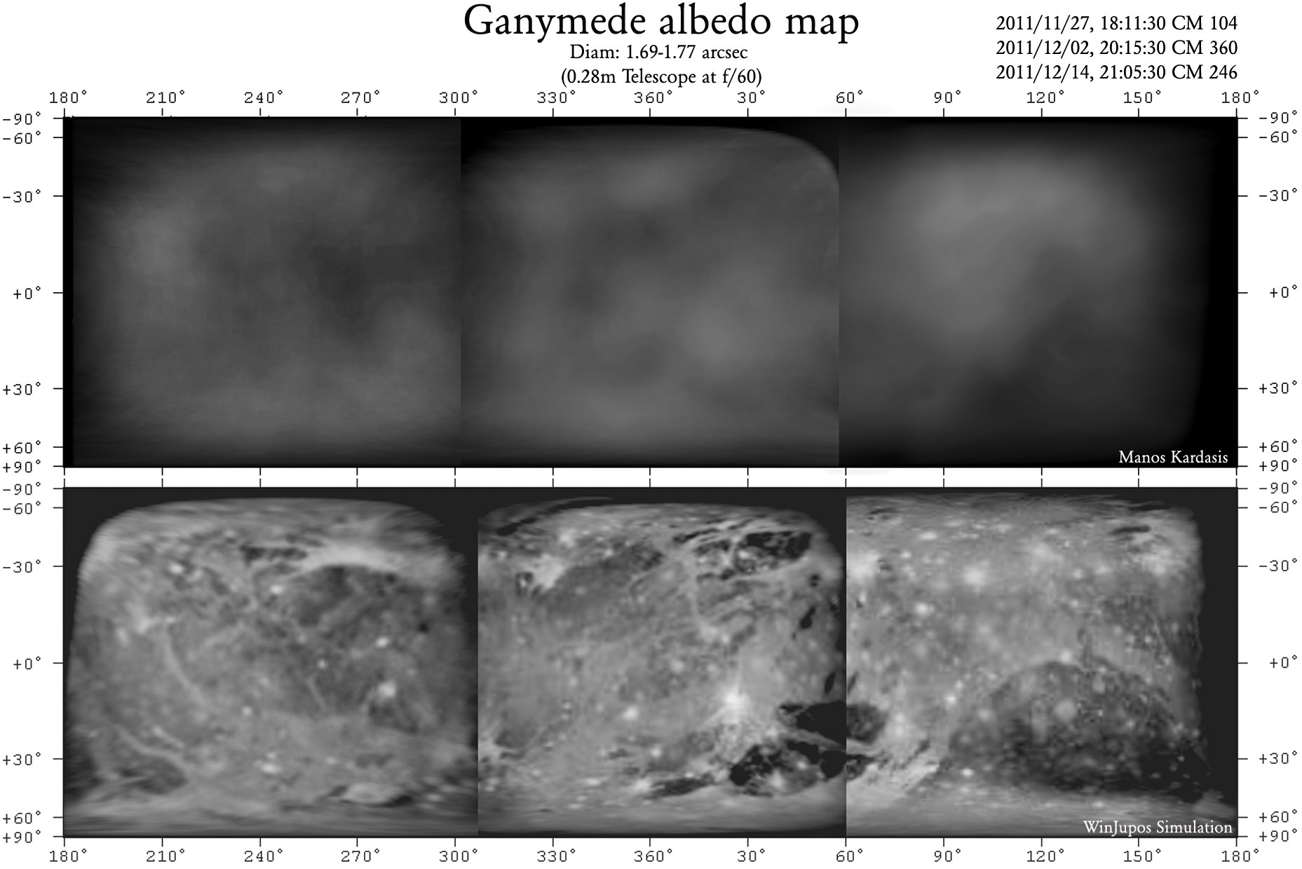
The original observations (top) and interpretations (bottom) of the first ever amateur albedo map of Ganymede. Credit: Manos Kardasis.

As our frequent “Astrophoto” posts from amateur astronomers and photographers attest – as well as the rise of citizen science — , the latest technology allows amatuers to make significant contributions to the field of astronomy. Case in point: Emmanuel I. Kardasis of the Hellenic Amateur Astronomy Association has produced the first amateur albedo map of Jupiter’s moon Ganymede. He used an off-the-shelf telescope, camera and computer equipment, but put his experienced observing skills to the test.

“Ganymede has a tiny disk as seen from Earth so was a good test for my techniques,” said Kardasis. “If the same methods were applied to other worlds, perhaps the volcanic moon Io, we could capture surface fluctuations. Professional observatories may create better images but they cannot monitor our rapidly and ever-changing Universe.”

Albedo maps of Ganymede (left) and how they relate to known surface features (right). Credit: Manos Kardasis.

Like many amateurs, Kardasis attached a camera to his telescope and recorded a video of Ganymede. Selecting only the sharpest frames of the video allowed him to obtain a series of images when the atmospheric conditions – known as ‘seeing’ – were most favorable. These best images were then stacked and aligned, before being enhanced through photo-editing software.

An albedo map details higher areas of reflectivity on an object’s surface recording where material is brighter or darker. Kardasis’ albedo map closely aligns with professional images of Ganymede’s surface, indicating features such as Phrygia Sulcus (furrows and ridges 3,700 km across) and the Nicholson region (a low-lying darker area).

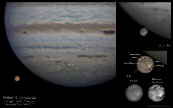
Amateur photographs of Jupiter and Ganymede, accompanied with a professionally-obtained labeled map (bottom right). Credit: Manos Kardasis.

“Creating useful images of planets requires a telescope with a diameter of at least eight inches, said Kardasis. “For tiny discs, such as the moons of Jupiter, bigger is definitely better. My Ganymede images were made using an 11-inch telescope. You also need a good motor drive on your tripod, a sensitive camera, some freely-available software, and lots of patience!”

Kardasis presented his images at the European Planetary Science Congress this week in Madrid, Spain. He suggests that future amateur programs could monitor both surface and atmospheric changes on worlds as varied as Uranus, Neptune and Titan, complementing more detailed but far less regular observations made by professionals. Kardasis says, “I hope my work will inspire anyone interested in astronomy to use whatever equipment they have to make useful observations.”

Source: EPSC

Planets in our Solar System May Have Formed in Fits and Starts

Solar shockwaves would have produced proto-planetary rings at different times, meaning the planets did not form simultaneously (artist concept). Credit: ESO.

Did all the planets in our Solar System form at about the same time? Conventional thinking says the components of our Solar System all formed at the same time, and formed rather quickly. But new research indicates that a series of shockwaves emitted from our very young Sun may have caused the planets to form at different times over millions of years.

“The planets formed in intervals – not altogether, as was previously thought,” said Dr. Tagir Abdylmyanov, Associate Professor from Kazan State Power Engineering University in Russia.

Abdylmyanov’s research, which models the movements of particles in fluids and gasses and in the gas cloud from which our Sun accreted, indicates that the first series of shockwaves during short but very rapid changes in solar activity would have created the proto-planetary rings for Uranus, Neptune, and dwarf planet Pluto first. Jupiter, Saturn, and the asteroid belt would have come next during a series of less powerful shockwaves. Mercury, Venus, Earth, and Mars would have formed last, when the Sun was far calmer. This means that our own planet is one of the youngest in the Solar System.

“It is difficult to say exactly how much time would have separated these groups,” Abdylmyanov said, “but the proto-planetary rings for Uranus, Neptune and Pluto would have likely formed very close to the Sun’s birth. 3 million years later and we would see the debris ring destined to form Saturn. Half a million years after this we would see something similar but for Jupiter. The asteroid belt would have begun to form about a million years after that, and another half a million years on we would see the very early stages of Mercury, Venus, Earth and Mars.”

The shockwaves emitted from the new-born Sun would have rippled out material at different times, creating a series of debris rings around the Sun from which the planets formed.

Abdylmayanov hopes that this research will help us understand the development of planets around distant stars. “Studying the brightness of stars that are in the process of forming could give indications as to the intensity of stellar shockwaves. In this way we may be able to predict the location of planets around far-flung stars millions of years before they have formed.”

His work was part of the European Planetary Science Congress taking place this week in Madrid, Spain.

Paddleboat Mission to Titan Proposed

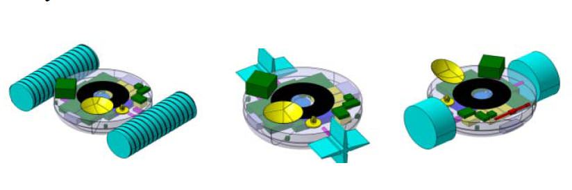
Three concepts for the TALISE boat mission to Titan: screw propelled (left), paddle wheels (center) and inflatable wheels (right). Credit: Urdampilleta, et al.

Is sending a boat to Titan an outlandish idea? Maybe, said a group of European scientists and engineers, but they’re working on a plan. The Titan Lake In-situ Sampling Propelled Explorer (TALISE) proposes a sending an instrument-laden boat-probe to Saturn’s largest moon that could be propelled by paddles, inflatable wheels or screws. The probe would land in the middle of Ligeia Mare – Titan’s biggest lake, near the moon’s north pole — then set sail for the coast, taking scientific measurements along the way.

“The main innovation in TALISE is the propulsion system,” says Igone Urdampilleta from SENER, an engineering company in Spain and a member of the TALISE team. “This allows the probe to move, under control, from the landing site in the lake, to the closest shore. The displacement capability would achieve the obtaining of liquid and solid samples from several scientific interesting locations on Titan’s surface such as the landing place, along the route towards the shore and finally at the shoreline.”

In a presentation at the European Planetary Science Congress on September 27, 2012, the TALISE team says that since Titan has a thick atmosphere, a diameter between that of Earth and the planet Mercury, and a network of seas, lakes and rivers, it is in many respects more like a planet than a moon.

And it’s time to go there and do a little in-situ science. The principle objective of the mission would be to characterize Titan’s environment and the chemical composition of the lakes and terrain.

While the Cassini-Huygens mission landed the Huygens probe on Titan in 2005, it transmitted data for only about 90 minutes after touchdown. The TALISE mission would last six months to a year.

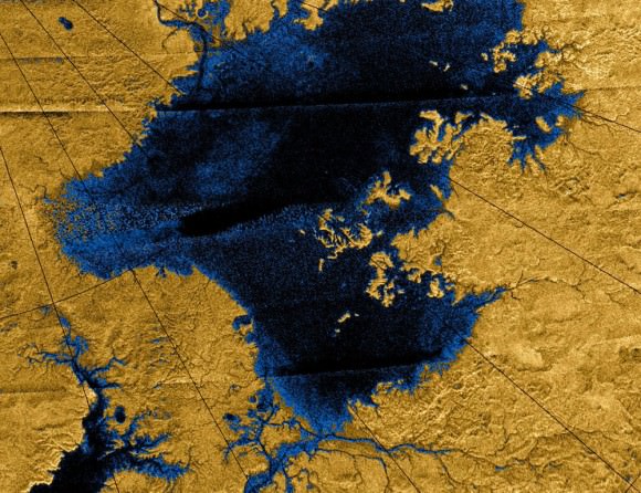
Images from the Cassini mission show river networks draining into the lakes in Titan’s north polar region. Credit: NASA/JPL/USGS

The Cassini orbiter has confirmed that lakes, seas and rivers of liquid hydrocarbons cover much of the Titan’s northern hemisphere, and these hydrocarbons may rain down on the surface, forming the frigid liquid bodies. With surface temperature at -178 degrees Celsius (-289 degrees Fahrenheit), Titan’s environment is too cold for life as we may know it, but its environment, rich in the building blocks of life, is of great interest to astrobiologists, the team said.

“The chemical composition of the lakes of Titan is still not well determined,” the TALISE team wrote in their abstract. “The detection of other compounds and the investigation of influence of both, photochemistry and the atmosphere on the chemical composition of liquids of Titan lakes remain challenging in the absence of in situ measurements. Therefore, it is next step to understand the Titan lakes environment, its relationship with the climate behavior, the surrounding solid substrate and analyze the organic inventory including the possibility of prebiotic compounds.”

The actual configuration of the boat is still under consideration, and they are considering various in-situ propulsion methods through the liquid hydrocarbon seas. In addition to paddle wheels, screw propulsion and inflatable wheels, they are also looking at tank wheels, air propeller, liquid propeller and a hovercraft design.

The TALISE concept is being developed as a partnership between SENER and the Centro de Astrobiología in Madrid, Spain, and the mission is still in the very early stages of feasibility studies and preliminary mission architecture design, but they are hoping to be ready for a future space science mission call for proposals.

Sources: EPSC, TALISE team abstract