Chasing The Little Prince in New York City

“One sees clearly only with the heart. Anything essential is invisible to the eyes.” – Antoine de Saint-Exupéry


I didn’t expect to find a story about a stranded aviator and a cosmos-travelling boy in the United Nations bookstore in New York City.

Yet there The Little Prince was, prominently displayed on a table near the door – an easy find in a bookstore dominated by tales of war, genocide and oppression of minorities.

Is there a special reason why Antoine de Saint-Exupéry’s message – of hope, of learning to judge yourself before others, and of keeping a childlike wonder about the world – is embedded in such a place, I wondered?

Purchased book in hand, I turned to the Internet for answers. Turns out the famed author and aviator lived in New York City for a time after escaping from occupied France in 1940. While there, he worked on three books, among them The Little Prince.

As a long-time fan of the book, I decided to go on a self-guided walking tour of his haunts. I only had about a day of tour time available and focused on two places: a restaurant and one of his homes.


La Vie Parisienne (3 East 52nd St.)

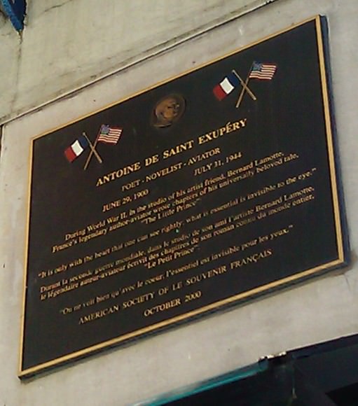
On the exterior of the second floor of a Midtown building rests a plaque commemorating Saint-Exupéry. In French and English, the plaque says several chapters of The Little Prince were written in a studio at 3 East 52nd St.

The studio actually was being used by Bernard Lamotte, a Parisian painter. It is said that his circle of artistic friends included luminaries such as actor-sketch writer Charlie Chaplin, actor-singer Marlene Dietrich, and of course, Saint-Exupéry.

Accounts say Saint-Exupéry was a writer who took to the skies to support his talents at the pen. Additionally, he drew on his experiences as an aviator in many of his writings, such as Southern Mail, Wind, Sand and Stars and Flight to Arras.

On the ground floor of the building was La Vie Parisienne (The Parisian Life), a French restaurant. Today, patrons can take in fine French dining at the same location courtesy of the restaurant La Grenouille (The Frog). The plaque is reportedly below where Lamotte’s table sat.


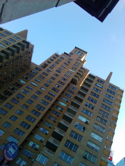
Saint-Exupéry’s residence (240 Central Park South)

Saint-Exupéry actually lived in three locations in the New York City area, but this one was the most accessible to me given time constraints.

Less than 20 minutes’ walk from La Vie Parisienne, Saint-Exupéry would have found the location an easy stroll from where he gathered with his friends. Just across the road from the six-decade-old building is Columbus Circle and Central Park itself, providing a respite from New York City’s busy streets if Saint-Exupéry desired it.

When Saint-Exupéry moved into the building in 1941, it was only a year old and considered to be very modern. Today, the two-tower building still looks very fresh courtesy of a renovation to its exterior a decade ago that among other things, restored the yellow-orange bricks to their former glory.

The Souvenir Français society (which honours members of the French military) initially wanted to place the plaque at this location. The owner denied them because he feared it would bring in tourists.


Saint-Exupéry yearned to defend his country and left for North Africa in 1943. He disappeared forever over the Mediterranean in 1944.

Still, New York City remembers him. As late as last year, a staged production of The Little Prince played at the New Victory Theatre, with the prince himself portrayed by a puppet.


All photos in those post taken by Elizabeth Howell. Historical information in this article, unless otherwise indicated, came from a 2001 article in The New York Times written by Christopher Gray.

Read Universe Today’s recent article on the B612 Foundation — named after the asteroid in “The Little Prince” — and plans to fund a private asteroid mapping mission.

Schweickart: Private Asteroid Mission is for the Benefit of Humanity

The B612 Foundation announced in June of this year that it plans to launch the first privately funded deep space mission, a space telescope that will map the inner solar system’s asteroid population and chart their orbits over the next hundred years. The goal is to find every potentially Earth-impacting object out there.

“This is a very practical — and necessary — project,” Rusty Schweickart, Chairman Emeritus of B612, and Apollo 9 astronaut told Universe Today. “It can be done, it is exciting and we are trying to get the world to recognize that this is a great investment in the future of humanity.”

Caption: Sentinel’s field of view. Credit: B612 Foundation.

The spacecraft is called Sentinel, and it will be equipped with a 20.5-inch cryo-cooled infrared telescope that will scan for space objects such as asteroids and comets. It will be placed in orbit around the Sun, ranging up to 170 million miles from Earth, for its mission of discovery and mapping.

B612 Foundation is nonprofit group of scientists and explorers who advocate exploration of asteroids and monitoring of their trajectories to protect the Earth from potentially catastrophic impacts. Other notable members of the Foundation include space shuttle and International Space Station astronaut Ed Lu (B612’s CEO), project architect Scott Hubbard, a Stanford professor who once served as the head of NASA’s Mars’ missions, and mission director Harold Reitsema, former director of space science missions at Ball Aerospace.

The foundation is named after the asteroid in Antoine de Saint-Exupery’s story “The Little Prince” which brought the young prince to various destinations, and originally the B612 Foundation focused on determining the best ways for deflecting a potential incoming asteroid. But it has since shifted its focus to the current project which involves only identifying dangerous near-Earth objects.

Read a new article, “Chasing the Little Prince in New York City”

“We have been working this issue for a number of years,” Schweickart said via phone, “and finding these asteroids is the next step that everyone agrees needs to be done.”

Schweickart said for years, the expectations were that NASA would be doing a project like this.

“But you know the situation in Washington,” he said. “With NASA’s budgeting outlook and the priorities NASA currently has, it doesn’t appear like this is something NASA could get to for a long time. We decided that, given what is going on with privatizations and with launch costs coming down, this was something on the scale that could be privately these days. And in recognizing the delay of not doing it ourselves, we decided to give it a go.”

While NASA’s Near-Earth Object program is scanning the skies and has found nearly 10,000 objects, or about 90 percent of the estimated objects larger than a half-mile across, according to B612, there are a half million more asteroids larger than the one that devastated the Tunguska region in northern Russia in 1908. Of those, only one percent has been mapped.

Schweickart said the launch of Sentinel would be a seminal step.

“It is the big step to locate almost all the objects of a size that can really do damage on the surface,” he said. “In five and a half years, we can meet very rapidly the goal of 90% of 140-meter-wide objects. But going down to the smaller ones that can still do damage, like the size of Tunguska, we should have about 50% of those that five and a half years. If we end up with an extended mission, which we’d definitely like to do, we should get to 60-70% completion of objects down to 40 meters.”

That would put over 500,000 objects in the Near Earth Object database, and Scheickart said, “the nice thing about asteroids is that once you’ve found them and once you have a good solid orbit on them you can predict a hundred years ahead of time whether there is a likelihood of an impact with the Earth.”

The Sentinel spacecraft is being built by Ball Aerospace and has been described as a mash-up of the Spitzer and Kepler space telescopes, both also designed by Ball. It’s wide-field, 24-million-pixel view should be able to map asteroids down to 40 meters.

B612 is targeting launch for 2017-2018, and their launch vehicle of choice is the SpaceX Falcon9.

Schweickart said Ball Aerospace has been working on the concept and design of this type of telescope for several years. “And we’ve been working with them on a daily basis for over a year now, so we are pretty confident that they can build this and we can launch and operate it,” he said, “but the new part of the challenge is raising the money.”

Currently B612 has specialists working on their funding, “and that is sufficient for now,” Schwieckart said. “As we move forward the costs will dramatically increase, no question. When you start bending metal and building spacecraft, and buying launch services you are talking a few hundred million dollars. But with anything like this, you raise that in stages.”

Since the announcement of the Sentinel mission comes closely on the heels of the Planetary Resources’ announcement of their own plans to privately travel to asteroids to mine them for minerals, Universe Today asked Schweickart to compare the Sentinel to Planetary Resource’s plans.

“Their plan is completely different,” Schweickart said. “We don’t have any relationship with them, but we’ve certainly talked with them. They are interested in developing resources from asteroids, and doing specific site surveillance of particular asteroids that they might want to use for resource development. But they have to know where to go. And our job is to find asteroids and map this territory – which is basically a region like a ‘donut’ around the Earth, so Planetary Resources will be consulting our maps, as many other people will, as well.”

And Schweickart added, “Our project has nothing to do with profit or investment for payback. This is for the survival and the benefit of humanity – everyone on Earth.”

But Schweickart called this territory of asteroids “the new frontier,” and protecting Earth is not the only reason for mapping asteroids. “It is not just planetary defense, it is also resources in the future, and places for human exploration, and it is science as well. We are going to end up with a map that can be used by many people.”

How difficult will it be for the Sentinel mission to be successful?

“You are talking to a technologist,” Schweickart said with a chuckle. “To me the technology is pretty straightforward, and we’ve got that pretty much in hand. But it is a different kind of project than what has been done before, so that is where the challenge lies. But I think this will be a very exciting process.”

For more information on the B612 Foundation and the Sentinel project and how you can donate, see the B612 Foundation website, or watch the video below.

Easiest Guide Ever to Watching the Perseid Meteor Shower

Caption: A bright fireball meteor on August 1, 2012. Credit: John Chumack.

This will probably be the most simple and easiest guide to viewing the Perseids and other meteor showers you may possibly ever read. The reason why it is so simple is when you are outside you want to concentrate on looking for meteors and not worrying about technical details, which are unnecessary for the casual observer.

First, a LITTLE about the Perseids: The Perseid meteor shower is an annual event occurring every August. They are tiny particles of dust and debris from the tail of a comet (109P/Swift-Tuttle) which planet Earth encounters every year in its orbit around the Sun. When these particles collide with the Earth’s atmosphere, they burn up causing bright flashes and streaks in the night sky. These are known as shooting stars or meteors.

Credit: NASA

To see Perseids (shooting stars/meteors) we only need to do a few simple things.

  1. Plan when you want to look for meteors: Check timings and set aside a good hour or more for observing (away from bright lights if possible). Meteors seldom appear immediately so give yourself a good hour or more to see as many as possible. Late evening and after midnight is a good time for meteor hunting. One of the best time to look, however, is during the dark hours immediately before dawn. There are some good guides with timings, etc. on www.meteorwatch.org, NASA, or Universe Today’s weekly SkyWatcher’s Forecast
  2. Get comfortable: Dress warmly as even in August it can get chilly at night. Find yourself a good garden chair, deck chair, trampoline or place on the ground you can lay a sleeping bag or blanket, as the idea is for you to keep your gaze on the sky for as long as possible. Lying down on the ground or sitting on a reclining garden chair will make this much easier for you. Take with you food and drink to make the evening even more enjoyable.
  3. Where to look: A lot of guides will tell you to look in certain directions at certain times and be far too technical, this is totally unnecessary. All you need to do is look up and fill your gaze with sky for as long as possible (blink and you miss it). Meteors/shooting stars from meteor showers tend to appear randomly all over the sky, they will however originate from a point called the radiant which gives the meteor shower its name the Perseids radiant/point of origin is in the constellation of Perseus, hence the name. You don’t need to look in any particular direction, just look up.
  4. How to look: You do not need a telescope, binoculars or any other viewing aid; you only need your eyes.
  5. What to expect: Don’t expect to see the heavens raining down with fire. Expect to see one or more bright flashes/ streaks of light (meteors/shooting stars) every few minutes. The Perseids can deliver fifty to a hundred meteors per hour at their peak, which is just after the night of the 11th and 12th August through to the 13th and 14th August, be patient and you will see some. Occasionally you may be lucky to see an incredibly bright meteor known as a fireball, these are a real treat. Also, as an added bonus this year, Jupiter, Venus, and the crescent Moon are gathering together in the night sky just as the Perseid meteor shower reaches its peak.

Enjoy yourself and keep looking up, the more you look up the more you will see. When you look away that’s when you miss the best meteor of the evening.

For further information and to join in with the worldwide #meteorwatch on twitter follow @virtualastro and visit meteorwatch.org

Good luck!

New Stunning ISS Time-lapse: Earth Illuminated

“If you could see the Earth illuminated when you were in a place as dark as night, it would look to you more spendid than the Moon.”

— Galileo Galilei.

400 years ago, Galileo could only imagine what the view of Earth would be like from space. Today, we have people on board the International Space Station who see that view every day. This new beautiful time-lapse shows aurora, lightning, our Milky Way Galaxy, city lights and other sights as seen from orbit.

Below is a great still image from this video, an amazing look through the ISS’s Cupola as Earth whizzes by:

Image caption: A view out the Cupola of the ISS. Credit: NASA

For more time-lapse videos and imagery, visit NASA’s Gateway to Astronaut Photography of Earth website.

Curiosity’s First 360-Degree Color Panorama

Doesn’t Gale Crater look lovely this time of year? This is the first 360-degree panorama of color images taken by Curiosity’s color Mast Camera. The individual images used in this first panorama may only have been thumbnail-sized, but the effect is no less stunning.

(Click the image to panoramify.)

 The images were acquired on August 9 EDT. Although taken during late afternoon at Gale crater, the individual images still had to be brightened as Mars only receives half the amount of sunlight that Earth does.

Full-size 1200×1200 pixel images will be available at a later date.

The two grey patches in the foreground at left and right are the result of Curiosty’s sky crane rockets blasting the Martian surface. Scientists will be investigating these areas as they expose material that was previously hidden beneath Mars’ red dust.

The base of Gale Crater’s 3.4-mile (5.5 km) high central peak, named Mt. Sharp in honor of planetary science pioneer Robert P. Sharp, can be seen in the distance at center. (Check out an oblique view of a portion of Mt. Sharp acquired by HiRISE camera here.)

You can play with an interactive 360-degree panorama at the NASATech website, put together by John O’Connor, and if you look closely, visible is the full JPL logo on the middle right wheel — in Morse Code!

As always, you can find more news from the MSL mission here.

Image: NASA/JPL-Caltech

Morpheus Lander Crashes and Burns

NASA’s “lean and green” Morpheus lander crashed and burned during a free flight test at Kennedy Space Center today, August 9, at approximately 12:46 pm EDT.

Watch a video of the failed test after the jump:


Designed in-house at Johnson Space Center, the Morpheus lander is engineered to use a liquid oxygen and methane fuel — relatively cheap materials that can be stored easily and would be available resources on other worlds besides Earth.

Morpheus’ first successful tethered flight had just occurred a few days earlier, on August 3.

It IS still rocket science, after all…

Images: NASA TV

Curiosity and the Mojave Desert of Mars – Panorama from Gale Crater

Image Caption: Curiosity and the Mojave Desert of Mars at Gale Crater North Rim, False Color Mosaic. This false color panoramic mosaic shows Curiosity in the foreground looking to the eroded rim of Gale Crater in the background. Visible at left is a portion of the RTG nuclear power source, low gain antenna pointing up, then the deployed High Gain antenna and other components of the rover deck. This mosaic was assembled from the three new full resolution Navcam images returned by Curiosity overnight and snapped on Sol 2 on Aug. 8. Image stitching by Ken Kremer and Marco Di Lorenzo. Topsoil at right foreground has been excavated by the descent landing thrusters to expose what the team believes is bedrock. See black and white version below. Credit: NASA/JPL-Caltech/Ken Kremer/Marco Di Lorenzo

Curiosity lead scientist John Grotzinger calls this place “The Mojave Desert” of Mars– that’s the sweet spot where NASA’s huge new Curiosity rover landed only 3 Sols, or days ago, and looks so “Earth-like”.

See above and below our new 3 frame panoramic mosaic showing Curiosity with a dramatic “Mojave Desert” backdrop – in false color and black and white – assembled from new pictures received overnight at JPL.

With her camera mast erected, Curiosity is beginning to beam back a flood of spectacular images and giving us the first detailed view of her new surroundings from her touchdown point inside Gale Crater on Mars beside a 3.4 mile (5.5 km) high layered mountain nicknamed Mount Sharp.

Overnight, Curiosity sent back many more full frame pictures from her Navcam navigation camera, including exquisite high resolution views of herself with the eroded rim of Gale Crater over her shoulder.

At Wednesday’s briefing, Grotzinger has ecstatic with the initial set of high resolution images showing Gale crater in the distance, saying;

“The thing that really struck the science team about this image, you would really be forgiven for thinking that NASA was trying to pull a fast one on you and we actually put a rover out in the Mojave Desert and took a picture.

“That’s the part of the rim that’s lowest in elevation, facing the northern lowlands of Mars.”

“The thing that’s amazing about this is to a certain extent the first impression you get is how earth-like this seems, looking at that landscape.”

The terrain is strewn with small pebbles that the team hypothesizes may stem from a nearby alluvial fan through which liquid water flowed long ago and is exactly why they chose Gale Crater as Curiosity’s landing site.

“The sedimentary materials, all those materials are derived from erosion of those mountains there, that’s the source region for this material,” Grotzinger said. “It’s really kind of fantastic.”

The first 360 color panorama from the Mastcam cameras are expected soon.

Ken Kremer

Image Caption: Curiosity and the Mojave Desert of Mars at Gale Crater North Rim. This false color panoramic mosaic shows Curiosity in the foreground looking to the eroded rim of Gale Crater in the background. Visible at left is a portion of the RTG nuclear power source, low gain antenna pointing up, then the deployed High Gain antenna and other components of the rover deck. This mosaic was assembled from the three new full resolution Navcam images returned by Curiosity overnight. Processing by Ken Kremer and Marco Di Lorenzo. Topsoil at right foreground has been excavated by the descent landing thrusters to expose what the team believes is bedrock. Credit: NASA/JPL-Caltech/Ken Kremer/Marco Di Lorenzo

Image Caption: Looking to Martian bedrock and Gale Crater North Rim, False Color- This two frame mosaic was assembled from the first two full resolution Navcam images returned by Curiosity on Sol 2 (Aug 8) and enhanced and colorized to bring out further details. Image sticthing and processing by Ken Kremer and Marco Di Lorenzo. Topsoil in the foreground has been excavated by the Sky crane descent landing thrusters to expose what the team believes is bedrock. Credit: NASA/JPL-Caltech/Ken Kremer/Marco Di Lorenzo – www.kenkremer.com

Incredible View of an Active Region on the Sun

Wow! What a view of Active Region 1542 on the Sun! César Cantú from the Chilidog Observatory in Monterrey, Mexico says this is “another way” of looking at the active region.

“It is an inverted image,” César said via email, which means it is essentially a negative which is then processed. “The process was done with software: Registax, PhotoshopCS5 and PixInsight,” he said.

César took this image on August 8, 2012. Note the incredible detail of the Sun’s swirling surface, the black bottomless pit of a sunspot, a tornadic-like prominence on the right and other wisps of solar material just above the surface.

He used a Meade 10 inch SC, with Coronado 90 mm and BF30 filters, along with a DMK31 camera. “The focal length is 2500 mm and correlated with the camera, approximately 210 X,” César said.

See the original at his website.

Want to get your astrophoto featured on Universe Today? Join our Flickr group or send us your images by email (this means you’re giving us permission to post them). Please explain what’s in the picture, when you took it, the equipment you used, etc.

Image caption: Active Region 1542 on August 8, 2012. Credit: César Cantú. Used by permission.

Curiosity raises Mast and snaps 1st Self Portrait and 1st 360 Panorama

Image Caption: Rover’s Self Portrait -This Picasso-like self portrait of NASA’s Curiosity rover was taken by its Navigation cameras, located on the now-upright mast. The camera snapped pictures 360-degrees around the rover, while pointing down at the rover deck, up and straight ahead. Those images are shown here in a polar projection. Most of the tiles are thumbnails, or small copies of the full-resolution images that have not been sent back to Earth yet. Two of the tiles are full-resolution. Credit: NASA/JPL-Caltech.
See below the 1st 360 degree panorama from Curiosity and an enhanced Sol 2 mosaic of the full resolution view of the north rim of Gale Crater by this author

The rover Curiosity continues her marathon run of milestone achievements – snapping her 1st self portrait and 1st 360 degree panorama since touchdown inside Gale Crater barely over 2 sols, or Martian days ago.

To take all these new images, Curiosity used a new camera, the just-activated higher resolution navigation cameras (Navcam) positioned on the mast. Several of the new images provide the best taste yet of the stupendous vistas coming soon. See our enhanced Sol 2 mosaic below.

The 3.6 foot-tall (1.1 meter) camera mast on the rover deck was just raised and activated earlier today, Wednesday, Aug. 8.

The mast deployment is absolutely crucial to Curiosity’s science mission. It is also loaded with the high resolution MastCam cameras and the ChemCam instrument with the laser rock zapper.

Most of the images Navcam images beamed back today were lower-resolution thumbnails. But 2 high-resolution Navcams from the panorama and the self portrait were also downlinked and provide the clearest view yet of the breathtaking terrain surrounding Curiosity in every direction.

“The full frame navcams show the north rim of Gale Crater,” said Justin Maki, MSL navcam lead, at a briefing today at JPL. “The Navcam’s are identical to the MER Navcam’s.”

The hi res images also show how the descent thruster excavated the topsoil like Phoenix.

Image Caption: Curiosity Looks Away from the Sun – This is the first 360-degree panoramic view from NASA’s Curiosity rover, taken with the Navigation cameras. Most of the tiles are thumbnails, or small copies of the full-resolution images that have not been sent back to Earth yet. Two of the tiles near the center are full-resolution. Mount Sharp is to the right, and the north Gale Crater rim can be seen at center. The rover’s body is in the foreground, with the shadow of its head, or mast, poking up to the right. These images were acquired at 3:30 pm on Mars, or the night of Aug. 7 PDT (early morning Aug. 8 EDT). Thumbnails are 64 by 64 pixels in size; and full-resolution images are 1024 by 1024 pixels. Credit: NASA/JPL-Caltech

Image Caption: Looking to Martian bedrock and Gale Carter North Rim, Enhanced Mosaic- This mosaic was assembled from the first two full resolution Navcam images returned by Curiosity on Sol 2 (Aug 8) and enhanced to bring out further details. Processing by Ken Kremer and Marco Di Lorenzo. Topsoil in the foreground has been excavated by the descent landing thrusters to expose what the team believes is bedrock. Credit: NASA/JPL-Caltech/Ken Kremer/Marco di Lorenzo

“These Navcam images indicate that our powered descent stage did more than give us a great ride, it gave our science team an amazing freebie,” said John Grotzinger, project scientist for the mission from the California Institute of Technology in Pasadena. “The thrust from the rockets actually dug a one-and-a-half-foot-long [0.5-meter] trench in the surface. It appears we can see Martian bedrock on the bottom. Its depth below the surface is valuable data we can use going forward.”

Gale Crater is unlike anything we’ve seen before on Mars.

It also distinctly reminded Grotzinger of Earth and looked to him like the rover set down in the Mojave desert. “The thing that’s amazing about this is to a certain extent the first impression you get is how earth-like this seems, looking at that landscape.”

Curiosity carries 10 science instruments with a total mass 15 times as large as the science payloads on NASA’s Mars rovers Spirit and Opportunity. Some of the tools, such as a laser-firing instrument for checking rocks’ elemental composition from a distance, are the first of their kind on Mars. Curiosity will use a drill and scoop, which are located at the end of its robotic arm, to gather soil and powdered samples of rock interiors, then sieve and parcel out these samples into the rover’s analytical laboratory instruments.

So far everything is going very well with Curiosity’s mechanical and instrument checkout. And there is even more power than expected from the RTG nuclear power source.

“We have more power than we expected and that’s going to be fantastic for being able to keep the rover awake longer,” said Mission manager Jennifer Trosper of JPL.

Ken Kremer

Looking to Martian bedrock and Gale Carter North Rim, Enhanced Mosaic with False Color- This mosaic was assembled from the first two full resolution Navcam images returned by Curiosity on Sol 2 (Aug 8) and enhanced and colorized to bring out further details. Processing by Ken Kremer and Marco Di Lorenzo. Topsoil in the foreground has been excavated by the descent landing thrusters to expose what the team believes is bedrock. Credit: NASA/JPL-Caltech/Ken Kremer/Marco di Lorenzo

Take a Flight Through Our Universe, Thanks to New 3-D Map of the Sky

The Sloan Digital Sky Survey III (SDSS-III) has released the largest three-dimensional map of massive galaxies and distant black holes ever created, and it pinpoints the locations and distances of over a million galaxies. It covers a total volume equivalent to that of a cube four billion light-years on a side.

A video released with the map takes viewers on an animated flight through the Universe as seen by SDSS. There are close to 400,000 galaxies in the animation, which places zoomed-in images of nearby galaxies at the positions of more distant galaxies mapped by SDSS.

“We want to map the largest volume of the universe yet, and to use that map to understand how the expansion of the universe is accelerating,” said Daniel Eisenstein (Harvard-Smithsonian Center for Astrophysics), the director of SDSS-III.

The map is the centerpiece of Data Release 9 (DR9), which publicly releases the data from the first two years of a six-year survey project. The release includes images of 200 million galaxies and spectra of 1.35 million galaxies. (Spectra take more time to collect than photographs, but provide the crucial third dimension by letting astronomers measure galaxy distances.)

“Our goal is to create a catalog that will be used long after we are done,” said Michael Blanton of New York University, who led the team that prepared Data Release 9.

The release includes new data from the ongoing SDSS-III Baryon Oscillation Spectroscopic Survey (BOSS), which will measure the positions of massive galaxies up to six billion light-years away, as well as quasars – giant black holes actively feeding on stars and gas – up to 12 billion light-years from Earth.

BOSS is targeting these big, bright galaxies because they live in the same places as other galaxies and they’re easy to spot. Mapping these big galaxies thus provides an effective way to make a map of the rest of the galaxies in the universe.

With such a map, scientists can retrace the history of the universe over the last six billion years. With that history, they can get better estimates for how much of the universe is made up of “dark matter” – matter that we can’t directly see because it doesn’t emit or absorb light – and “dark energy,” the even more mysterious force that drives the accelerating expansion of the universe.

“Dark matter and dark energy are two of the greatest mysteries of our time,” said David Schlegel of Lawrence Berkeley National Laboratory, the principal investigator of BOSS. “We hope that our new map of the universe can help someone solve the mystery.”

This release is being issued jointly with the SDSS-III Collaboration.

All the data are available now on the Data Release 9 website at http://www.sdss3.org/dr9. The new data are being made available to astronomers, as well as students, teachers, and the public. The SkyServer website includes lesson plans for teachers that use DR9 data to teach astronomy and other topics in science, technology, and math. DR9 data will also feature in a new release of the Galaxy Zoo citizen science project, which allows online volunteers to contribute to cutting-edge astronomy research.

Image caption: This is a still image from the fly-through video of the SDSS-III galaxies mapped in Data Release 9. Credit: Miguel A. Aragón (Johns Hopkins University), Mark SubbaRao (Adler Planetarium), Alex Szalay (Johns Hopkins University), Yushu Yao (Lawrence Berkeley National Laboratory, NERSC), and the SDSS-III Collaboration

Source: CfA