Greenland Glacier Calves Another Huge Ice Island

Petermann glacier, a 70 km (43 mile) long tongue of ice that flows into the Arctic Ocean in northwest Greenland, recently calved an “ice island” approximately 130 square kilometers (50 sq. miles) — about twice the area of Manhattan. The image above, acquired by NASA’s Terra satellite, shows the ice island as it drifts toward the ocean five days after breaking off the main glacier.

Petermann glacier has been known for birthing massive ice islands; previously in August 2010 an even larger island broke away from the glacier, measuring 251 square kilometers (97 sq. miles). That slab of ice eventually drifted into the northern Atlantic and was even visible from the Space Station a year later!

Read: Manhattan-Sized Ice Island Seen From Space

Although some of Greenland’s glaciers have been observed to be quickening their seaward pace as a result of global warming, this particular calving event — which occurred along a crack that appeared in 2001 satellite imagery — isn’t thought to be a direct result of climate but rather of ocean currents and isn’t expected to have any significant effect on the rate of Greenland’s ice loss as a whole. Still, satellite observation of such events provides valuable data for researchers monitoring the processes that are involved with rapidly accelerating Arctic ice loss.

And if you want an idea of what a slab of ice this large looks like up close, here’s a video taken by researchers on approach to a smaller chunk of the 2011 island:

NASA Earth Observatory image by Jesse Allen, using data from NASA/GSFC/METI/ERSDAC/JAROS, and U.S./Japan ASTER Science Team. (NASA/Terra)

Carnival of Space #259

This week’s Carnival of Space is hosted by Gadi Eidelheit at his Transit of Venus blog.

Click here to read Carnival of Space #259

And if you’re interested in looking back, here’s an archive to all the past Carnivals of Space. If you’ve got a space-related blog, you should really join the carnival. Just email an entry to [email protected], and the next host will link to it. It will help get awareness out there about your writing, help you meet others in the space community – and community is what blogging is all about. And if you really want to help out, sign up to be a host. Send an email to the above address.

Sally Ride, First American Woman in Space, Passes Away

Dr. Sally Ride, the first American woman to fly in space, died today, July 23, 2012. She was 61 years old.


Dr. Ride flew in space twice, first in 1983 aboard the Space Shuttle Challenger, then again aboard Challenger in 1984. She was the President and CEO of Sally Ride Science, a science education company that creates programs and products for students and teachers in elementary and middle school with a focus on encouraging girls. Dr. Ride was also a Professor of Physics (Emerita) at the University of California, San Diego. She received her B.S in Physics, B.A in English, and M.S. and PhD in Physics from Stanford University.

Sally died peacefully July 23 after a courageous 17-month battle with pancreatic cancer. She lived her life to the fullest, with boundless energy, curiosity, intelligence, passion, commitment, and love. Her integrity was absolute; her spirit was immeasurable; her approach to life was fearless.

“Sally Ride broke barriers with grace and professionalism – and literally changed the face of America’s space program. The nation has lost one of its finest leaders, teachers and explorers. Our thoughts and prayers are with Sally’s family and the many she inspired. She will be missed, but her star will always shine brightly.”

– Charles Bolden, NASA Administrator

For more information visit http://www.sallyridescience.com/.

“I didn’t really think about it that much at the time . . . but I came to appreciate what an honor it was to be selected to be the first to get a chance to go into space.” 

– Dr. Sally Ride, former NASA astronaut

(NASA/JPL video from July 2008)

Photo and video: NASA

Flashback: 1978 NASA Film Shows Viking Discoveries

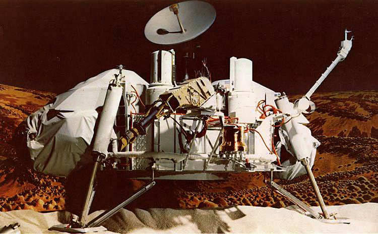
In what’s a sort of foreshadowing of the upcoming August 5 MSL landing, which is being called “seven minutes of terror”, here’s a flashback film from 1978 called “19 Minutes to Earth” which looks at the discoveries made by the Viking orbiter and lander, which made its historic arrival on Mars 36 years ago, on July 20, 1976.

In true late ’70s style the video is full of funky music and (what was then) state-of-the-art video graphics. Awesome.


Even more than the music, though, what’s interesting about the 1978 film is how the subject of microbial life is discussed. Both Viking 1 and 2 were designed to search for evidence of biological activity on Mars, which they did by digging into the Martian soil and looking for signs of resulting respiration.

Although the results were initially deemed inconclusive, further research into the Viking data has prompted some scientists to claim that the landers did, in fact, find evidence of life on Mars.

It’s still a much-debated topic, one that scientists hope to help settle with the upcoming research performed by Curiosity and the Mars Science Laboratory mission.

Funky music and all, the Viking programs paved the way for all future missions to Mars. Lessons learned from Viking technology have blazed the trail for Mars research, from Pathfinder’s Sojourner rover to Spirit and Opportunity, the Mars Reconnaissance Orbiter and ESA’s Mars Express. Very soon Curiosity will continue on with the legacy of robotic exploration of the Red Planet, and someday I’m sure our children and grandchildren will look back at the “funky videos” of our time.

Let’s hope that by then they’ve made their own great strides in space exploration and have found answers to the questions that inspire us today.

Video: NASA. Image: artist’s concept of the Viking lander (NASA).

Hypersonic Inflatable Heat Shield Tested Successfully

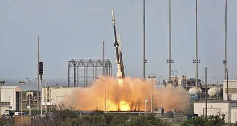
Caption: IRVE-3 was launched by a sounding rocket at 7:01 a.m. Mon., July 23, from NASA’s Wallops Flight Facility. Credit: NASA.

A prototype for a large inflatable heat shield that could one day be used for landing large payloads on Mars was tested successfully on July 23, 2012, surviving a hypersonic speeds through Earth’s atmosphere. The Inflatable Reentry Vehicle Experiment (IRVE-3) traveled at speeds up to 12,231 km/h (7,600 mph) after launching on a sounding rocket from NASA’s Wallops Flight Facility on Wallops Island, Virginia.

“We had a really great flight today,” said James Reuther, deputy director of NASA’s Space Technology Program, after the test flight. “Initial indications are we got good data. Everything performed as well, or better, than expected.

Watch the video from the flight below.

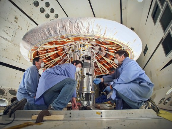
IRVE-3 is a cone of uninflated high-tech rings covered by a thermal blanket of layers of heat resistant materials. NASA said the purpose of the IRVE-3 test was to show that a space capsule can use an inflatable outer shell to slow and protect itself as it enters an atmosphere at hypersonic speed during planetary entry and descent, or as it returns to Earth with cargo from the International Space Station. A larger version has been proposed for landing larger payloads on Mars, such as future human missions.

About 6 minutes into today’s flight, as planned, the 680-pound inflatable aeroshell, or heat shield, and its payload separated from the launch vehicle’s 55 cm (22-inch)-diameter nose cone about 450 km (280 miles) over the Atlantic Ocean.

An inflation system pumped nitrogen into the IRVE-3 aeroshell until it expanded to a mushroom shape almost 3 meters (10 feet) in diameter. Then the aeroshell plummeted at hypersonic speeds through Earth’s atmosphere. Engineers in the Wallops control room watched as four onboard cameras confirmed the inflatable shield held its shape despite the force and high heat of reentry. Onboard instruments provided temperature and pressure data. Researchers will study that information to help develop future inflatable heat shield designs.


Caption: Technicians prepare the Inflatable Reentry Vehicle Experiment (IRVE-3). Credit: NASA

A Navy crew will attempt to retrieve the aeroshell.

“It’s great to see the initial results indicate we had a successful test of the hypersonic inflatable aerodynamic decelerator,” said James Reuther, deputy director of NASA’s Space Technology Program. “This demonstration flight goes a long way toward showing the value of these technologies to serve as atmospheric entry heat shields for future space missions.”

IRVE-3 is part of the Hypersonic Inflatable Aerodynamic Decelerator (HIAD) Project within the Game Changing Development Program, part of NASA’s Space Technology Program.

Source: NASA

The Top 5 “Earth as Art” Images, Thanks to Landsat

NASA’s first Earth-observing Landsat satellite launched from Vandenberg Air Force Base on July 23, 1972, and to celebrate the 40th anniversary of the program they asked the public to vote on their favorite images of the planet from the Landsat Earth as Art gallery. After over 14,000 votes, these were chosen as the top 5 favorites. Happy 40th anniversary, Landsat!

Landsat images from space are not merely pictures. They contain many layers of data collected at different points along the visible and invisible light spectrum. A single Landsat scene taken from 400 miles above Earth can accurately detail the condition of hundreds of thousands of acres of grassland, agricultural crops or forests.

“Landsat has given us a critical perspective on our planet over the long term and will continue to help us understand the big picture of Earth and its changes from space,” said NASA Administrator Charles Bolden. “With this view we are better prepared to take action on the ground and be better stewards of our home.”

In cooperation with the U.S. Geological Survey (USGS), a science agency of the Interior Department, NASA launched six of the seven Landsat satellites. The resulting archive of Earth observations forms a comprehensive record of human and natural land changes.

“The first 40 years of the Landsat program have delivered the most consistent and reliable record of Earth’s changing landscape.”

– Michael Freilich, director of NASA’s Earth Science Division

“Over four decades, data from the Landsat series of satellites have become a vital reference worldwide for advancing our understanding of the science of the land,” said Interior Department Secretary Ken Salazar. “The 40-year Landsat archive forms an indelible and objective register of America’s natural heritage and thus it has become part of this department’s legacy to the American people.”

The next satellite in the series, the Landsat Data Continuity Mission (LDCM) is scheduled to launch on February 11, 2013.

(Source: NASA/GSFC)

Find out more about the ongoing Landsat mission here, and see recent visualizations from Landsat on the USGS site here.

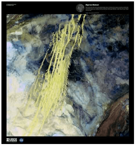
Video: NASA/GSFC. Inset image: Industrial growth in Binhai New Area, China.  Sub-feature: Erg Iguidi, an area of ever-shifting sand dunes extending from Algeria into Mauritania in northwestern Africa, one of the chosen top 5 Earth as Art images. NASA/GSFC/USGS.

HI-C Returns Most Detailed Images Ever of the Sun’s Corona

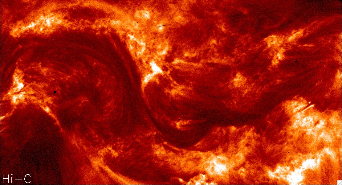
NASA’s High Resolution Coronal Imager (Hi-C) mission, launched Wednesday, July 11 from White Sands Missile Range in New Mexico, successfully returned (as promised!) the highest-resolution images of the Sun’s corona ever acquired. These images of the dynamic million-degree region of the Sun’s atmosphere will provide scientists with more information on the complex activity found near the Sun’s surface and how it affects space weather throughout the Solar System.

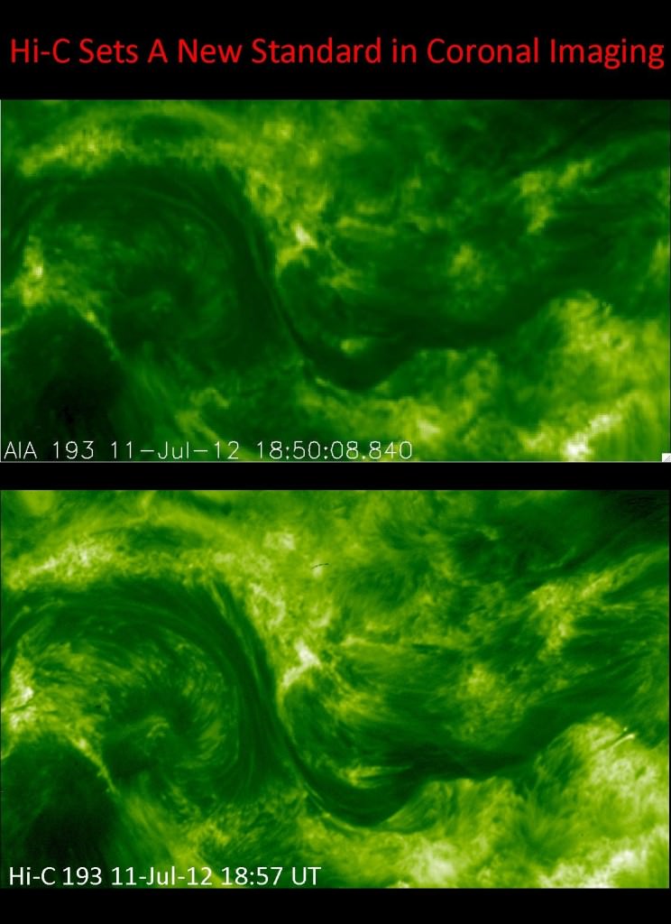
Launched aboard a 58-foot-tall (17 meter) Black Brant sounding rocket, Hi-C was equipped with exceptionally well-made mirrors — some of the finest ever made, according to the mission report. These mirrors allowed Hi-C to image a section of the Sun’s corona in extreme ultraviolet light with a resolution of 0.1 arcsec/pixel, distinguishing features as small as 135 miles (217 km) across. That’s five times the resolution of SDO images, or any previous space telescope for that matter.

That’s like the difference between watching a program on a tube television and an HD flatscreen monitor.

The image below shows the same region as seen by SDO’s AIA array and Hi-C’s innovative mirror-and-“light-maze” system:

Read: NASA to Launch the Finest Mirrors Ever Made

“These revolutionary images of the sun demonstrate the key aspects of NASA’s sounding rocket program, namely the training of the next generation of principal investigators, the development of new space technologies, and scientific advancements,” said Barbara Giles, director for NASA’s Heliophysics Division at NASA Headquarters in Washington.

During its 620-second suborbital flight, Hi-C took 165 images of a section of the Sun’s corona 135,000 miles (271,000 km) across, capturing wavelengths of light at 193 Angstroms emitted by the Sun’s super-hot 1.5 million kelvin corona. The images were focused on a large sunspot region, whose position was accurately predicted 27 days prior to launch.

“We have an exceptional instrument and launched at the right time,” said Jonathan Cirtain, senior heliophysicist at NASA’s Marshall Space Flight Center in Huntsville. “Because of the intense solar activity we’re seeing right now, we were able to clearly focus on a sizeable, active sunspot and achieve our imaging goals.”

Even though Hi-C’s flight only lasted ten minutes, of which 330 seconds were used for acquiring images, the amount of data gathered will be used by researchers for months.

“Even though this mission was only a few minutes long, it marks a big breakthrough in coronal studies,” said Leon Golub, lead investigator from the Harvard-Smithsonian Center for Astrophysics. “The Hi-C flight might be the most productive five minutes I’ve ever spent.”

Watch a 10-second video of the region shown above, seen from both Hi-C and SDO:

Read more about the Hi-C mission results here.

Image credits: NASA

An Orbital Adagio: Nighttime Views from the ISS

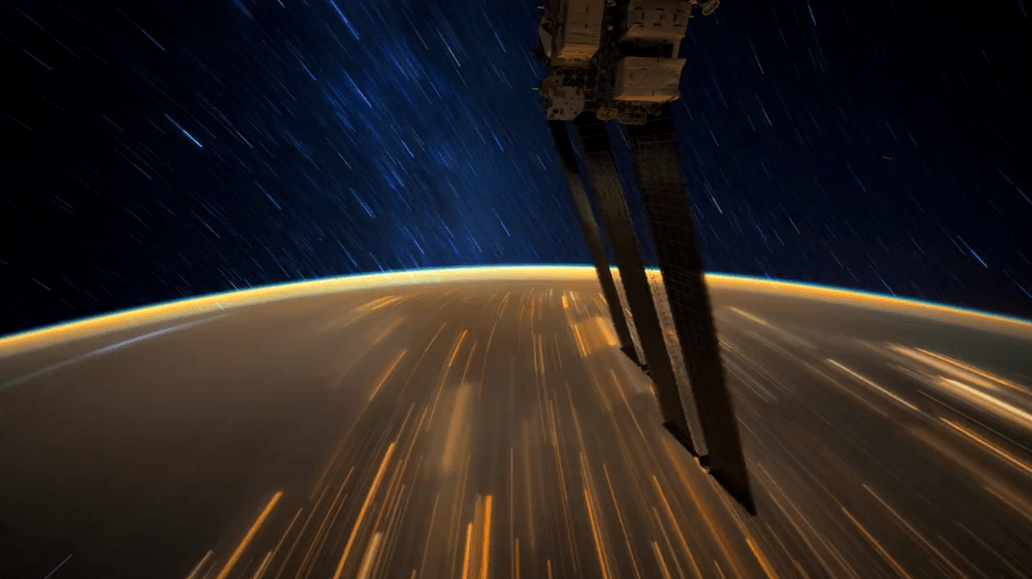
People keep making these videos from ISS photography, and we keep loving them. Here’s the latest, assembled by photographer Knate Myers to a track by John Murphy (from the movie soundtrack for Sunshine) it’s a beautiful tour of nighttime passes of the Space Station over our planet. Stars, city lights, airglow, aurorae… it’s nothing you haven’t seen before, but everything worth seeing again. Watch it.

Video: Knate Myers. All images courtesy of the Image Science & Analysis Laboratory, NASA Johnson Space Center. Via the Gateway to Astronaut Photography of Earth.

Weekly SkyWatcher’s Forecast: July 23-29, 2012

IC 4665 - Credit: Palomar Observatory, courtesy of Caltech

Greetings, fellow SkyWatchers! Are you ready for a week filled with alternative astronomical observing studies? If so, you’ll enjoy looking at some unusual stars and star clusters. If you want to keep things cool, then come along as we mine for lunar ice. Feeling a bit more lazy? Then kick back and enjoy the Delta Aquarid meteor shower or just step out after sunset and enjoy a splendid conjunction! It’s all here… Just head outside!

Monday, July 23 – Tonight we’ll launch our imaginations as we view the area around Mare Crisium and have a look at this month’s lunar challenge – Macrobius. You’ll find it just northwest of the Crisium shore. Spanning 64 kilometers in diameter, this Class I impact crater drops to a depth of nearly 3600 meters – about the same as many of our earthly mines. Its central peak rises up 1100 meters, and may be visible as a small speck inside the crater’s interior. Be sure to mark your lunar challenges and look for other features you may have missed before!

Now, relax and let’s talk until the Moon sets…

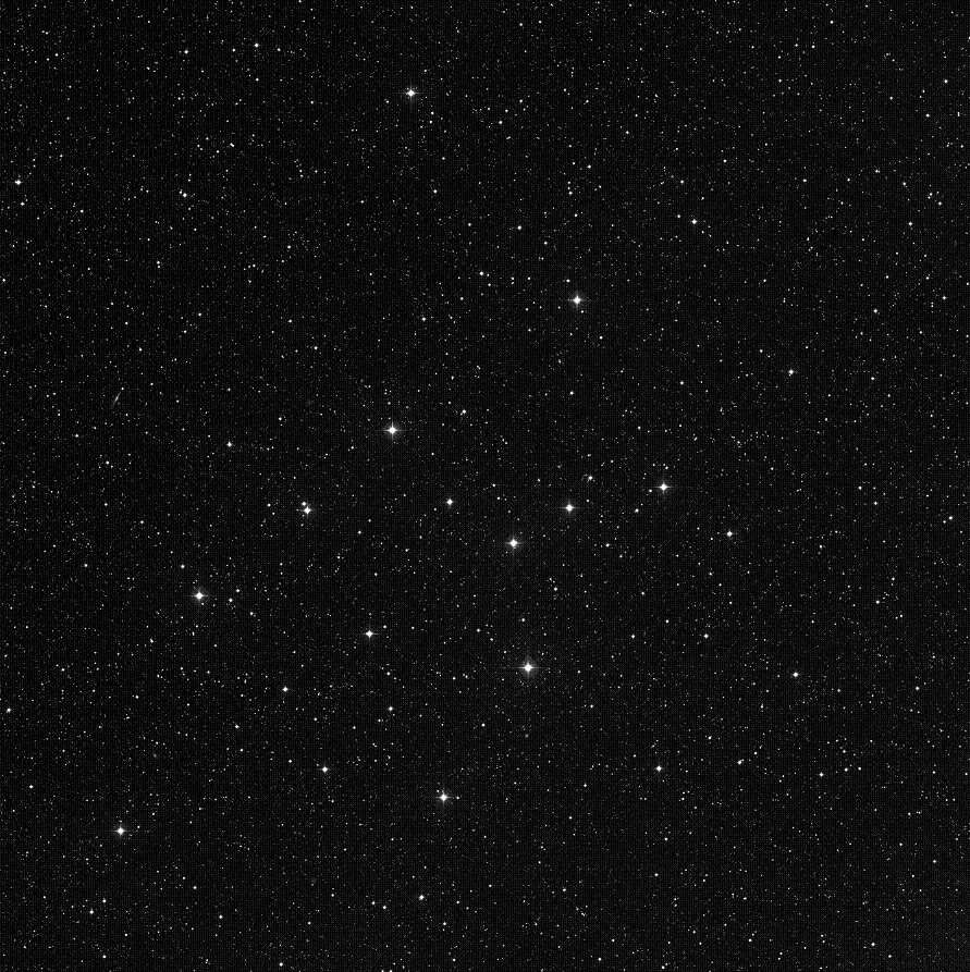
As we know most stars begin life in stellar nurseries and end life either alone or in very small groups as doubles or multiple stars. Tonight we can have a look at a group of young stars beginning their stellar evolution and end with an old solitary elder preparing to move on to an even “higher realm.” Open cluster IC 4665 (Right Ascension: 17 : 46.3 – Declination: +05 : 43) is easily detected with just about any optical aid about a finger-width north-northeast of Beta Ophiuchi. Discovered by Philippe Loys de Cheseaux in the mid-1700s, this 1400 light-year distant cluster consists of about 30 mixed magnitude stars all less than 40 million years of age. Despite its early discovery, the cluster did not achieve broad enough recognition for Dreyer to include it in the late 19th century New General Catalog and it was later added as a supplement to the NGC in the Index Catalog of 1908. Be sure to use low power to so see all of this large group.

About three finger-widths north-northeast of IC 4665 is a study that did make Dreyer’s catalogue – NGC 6572 (Right Ascension: 18 : 12.1 – Declination: +06 : 51). This 9th magnitude planetary is very small – but intense. Like the “Cat’s Eye” in Draco, and NGC 6210 in Hercules, this planetary can take a lot of magnification. Those with large scopes should look for a small, round, blue inner core encased is a faint shell. A challenge to find? You bet. Worth the work? Sometimes working for something makes it all the more fun!

Tuesday, July 24 – As our observing evening begins, be sure to look for one of the finest conjunctions of the year! Hovering around the waxing crescent Moon like bees drawn to a hive, you’ll find Mars to the upper right and Spica to the upper left (northwest and northeast respectively). To Spica’s upper right, you’ll find Saturn joining the show, too! This is a very “photogenic” opportunity…

With plenty of Moon to explore tonight, why don’t we try locating an area where many lunar exploration missions made their mark? Binoculars will easily reveal the fully disclosed areas of Mare Serenitatis and Mare Tranquillitatis, and it is where these two vast lava plains converge that we will set our sights. Telescopically, you will see a bright “peninsula” westward of where the two conjoin which extends toward the east. Just off that look for bright and small crater Pliny. It is near this rather inconspicuous feature that the remains Ranger 6 lie forever preserved where it crashed on February 2, 1964.

Unfortunately, technical errors occurred and it was never able to transmit lunar pictures. Not so Ranger 8! On a very successful mission to the same relative area, this time we received 7137 “postcards from the Moon” in the last 23 minutes before hard landing. On the “softer” side, Surveyor 5 also touched down near this area safely after two days of malfunctions on September 10, 1967. Incredibly enough, the tiny Surveyor 5 endured temperatures of up to 283 degrees F, but was able to spectrographically analyze the area’s soil… And by the way, it also managed to televise an incredible 18,006 frames of “home movies” from its distant lunar locale.

Wednesday, July 25 – Today in 1971, Apollo 15 was launched on its way towards the Moon, and we’ll continue our celebration of space exploration and walk on the Moon where the first man set foot. For SkyWatchers, the dark round area you see on the northeastern limb is Mare Crisium and the dark area below that is Mare Fecunditatis. Now look mid-way on the terminator for the dark area that is Mare Tranquillitatis. At its southwest edge, history was made.

In binoculars, trace along the terminator where the Caucasus Mountains stand – and then south for the Apennines and the Haemus Mountains. As you continue towards the center of the Moon, you will see where the shore of Mare Serenitatis curves east, and also the bright ring of Pliny. Continue south along the terminator until you spot the small, bright ring of Dionysius along the edge of Mare Tranquillitatis. Just to the southwest, you may be able to see the soft rings of Sabine and Ritter. It is near here where the base section of the Apollo 11 landing module – Eagle – lies forever enshrined in “magnificent desolation.”

For telescope users, the time is now to power up! See if you can spot small craters Armstrong, Aldrin and Collins just east. Even if you cannot, the Apollo 11 landing area is about the same distance as Sabine and Ritter are wide to the east-southeast. Even if you don’t have the opportunity to see it tonight, take the time during the next couple of days to point it out to your children, grandchildren, or even just a friend… The Moon is a spectacular world and we’ve been there!
Tonight let’s have a look with our eyes first at Delta Ophiuchi. Known as Yed Prior (“The Hand”), look for its optical double Epsilon to the southeast: Yed Posterior. Now have a look in binoculars or a telescope at absolute minimum power for another undiscovered gem…

Delta Ophiuchi is 170 light-years from us, while Epsilon is 108 – but look at the magnificent field they share. Stars of every spectral type are in an area of sky which could easily be covered by a small coin held at arm’s length. Enjoy this fantastic field – from the hot, blue youngsters to the old red giants!

Thursday, July 26 – Long before the Sun sets, look for the Moon to appear in the still-blue sky. As it darkens, watch for shadows on the surface. Have you ever wondered if there was any place on the lunar surface that hasn’t seen the sunlight? Then let’s go searching for one tonight…

Our first order of business will be to identify crater Albategnius. Directly in the center of the Moon is a dark floored area known as Sinus Medii. South of it will be two conspicuously large craters – Hipparchus to the north and ancient Albategnius to the south. Trace along the terminator toward the south until you have almost reached its point (cusp) and you will see a black oval. This normal looking crater with the brilliant west wall is equally ancient crater Curtius. Because of its high southern latitude, we shall never see the interior of this crater – and neither has the Sun! It is believed that the inner walls are quite steep and that Curtius’ interior has never been illuminated since its formation billions of years ago. Because it has remained dark, we can speculate that there may be “lunar ice” pocketed inside its many cracks and rilles that date back to the Moon’s formation!

Because our Moon has no atmosphere, the entire surface is exposed to the vacuum of space. When sunlit, the surface reaches up to 385 K, so any exposed “ice” would vaporize and be lost because the Moon’s gravity cannot hold it. The only way for “ice” to exist would be in a permanently shadowed area. Near Curtius is the Moon’s south pole, and the Clementine spacecraft’s imaging showed around 15,000 square kilometers in which such conditions could exist. So where did this “ice” come from? The lunar surface never ceases to be pelted by meteorites – most of which contain water ice. As we know, many craters were formed by just such impacts. Once hidden from the sunlight, this “ice” could remain for millions of years!

Friday, July 27 – Tonight let’s skip the Moon and take a look at an astounding system called 36 Ophiuchi, located about a thumb’s width southeast of Theta. Situated in space less than 20 light-years from Earth, even small telescopes can split this pair of 5th magnitude K type giants very similar to our own Sun, and larger telescopes can also pick up the C component as well. 36 Ophiuchi B is also known as system 544…because it has what could very likely be a planet in a habitable zone!

Now we’ll have a look at a beautifully contrasting pair of stars – Zeta 1 and 2 Scorpii. You’ll find them a little less than a handspan south-southeast of Antares and at the western corner of the J of the constellation’s shape.

Although the two Zetas aren’t a true physical pair, they are nonetheless interesting. The easternmost, orange sub-giant Zeta 2 appears far brighter for a reason… It’s much closer at only 155 light-years away. But, focus your attention on western Zeta 1. It’s a blue supergiant that’s around 5700 light-years away and shines with the light of 100,000 suns and exceeds even Rigel in sheer power! The colorful pair is easily visible as two separate stars to the unaided eye, but a real delight in binoculars or a low power telescope field. Check them out tonight!

Saturday, July 28 – Tonight let’s continue our studies of the lunar poles by returning to previous study crater Plato. North of Plato you will see a long horizontal area with a gray floor – Mare Frigoris. North of it you will note a double crater. This elongated diamond-shape is Goldschmidt and the crater which cuts across its western border is Anaxagoras. The lunar north pole isn’t far from Goldschmidt, and since Anaxagoras is just about one degree outside of the Moon’s theoretical “arctic circle” the lunar sun will never go high enough to clear the southernmost rim.

On March 5, 1998, NASA announced that Lunar Prospector’s neutron spectrometer data showed that water ice had been discovered at both lunar poles. The first results showed the ice was mixed in with lunar regolith (soil, rocks and dust), but long term data confirmed near pure pockets hidden beneath about 40 cm of surface material – with the results being strongest in the northern polar region. It is estimated there may be as much as 6 trillion kg (6.6 billion tons) of this valuable resource! If this still doesn’t get your motor running, then realize that without it, we could never establish a manned lunar base because of the tremendous expense involved in transporting our most basic human need – water.

The presence of lunar water could also mean a source of oxygen, another vital material we need to survive! And for returning home or voyaging further, these same deposits could provide hydrogen which could be used as rocket fuel. So as you view Anaxagoras tonight, realize that you may be viewing one of mankind’s future “homes” on a distant world!

Now grab a comfortable seat because the Delta Aquarid meteor shower reaches its peak tonight. It is not considered a prolific shower, and the average fall rate is about 25 per hour – but who wouldn’t want to take a chance on observing a meteor about every 4 to 5 minutes? These travelers are considered to be quite slow, with speeds around 24 kilometers per second and are known to leave yellow trails. One of the most endearing qualities of this annual shower is its broad stream of around 20 days before and 20 days after peak. This will allow it to continue for at least another week and overlap the beginning stages of the famous Perseids.

The Delta Aquarid stream is a complicated one, and a mystery not quite yet solved. It is possible that gravity split the stream from a single comet into two parts, and each may very well be a separate stream. One thing we know for certain is they will seem to emanate from the area around Capricornus and Aquarius, so you will have best luck facing southeast and getting away from city lights. Although the Moon will interfere, just relax and enjoy a warm summer night. It’s time to catch a “falling star!”

Sunday, July 29 – Tonight let’s take an entirely different view of the Moon as we do a little “mountain climbing!” The most outstanding feature on the Moon will be the emerging Copernicus, but since we’ve delved into the deepest areas of the lunar surface, why not climb to some of its peaks?

Using Copernicus as our guide, to the north and northwest of this ancient crater lie the Carpathian Mountains, ringing the southern edge of Mare Imbrium. As you can see, they begin well east of the terminator, but look into the shadow! Extending some 40 kilometers beyond the line of daylight, you will continue to see bright peaks – some of which reach 2072 meters high! When the area is fully revealed tomorrow, you will see the Carpathian Mountains eventually disappear into the lava flow that once formed them. Continuing onward to Plato, which sits on the northern shore of Imbrium, we will look for the singular peak of Pico. It is between Plato and Mons Pico that you will find the scattered peaks of the Teneriffe Mountains. It is possible that these are the remnants of much taller summits of a once stronger range, but only around 1890 meters still survives above the surface.

Time to power up! Lather, rinse and repeat until you know these by heart… To the west of the Teneriffes, and very near the terminator, you will see a narrow series of hills cutting through the region west-southwest of Plato. This is known as the Straight Range – Montes Recti – and some of its peaks reach up to 2072 meters. Although this doesn’t sound particularly impressive, that’s over twice as tall as the Vosges Mountains in central Europe and on the average very comparable to the Appalachian Mountains in the eastern United States. Not bad!

Now head about a palm’s width east of our previous study star – Zeta Scorpii – for lovely Theta. Named Sargas, this 1.8 magnitude star resides around 650 light-years distant in a very impressive field of stars for binoculars or a small telescope. While all of these are only optical companions, the field itself is worth a look – and worth remembering for the future.

About three fingerwidths north is true double Lambda Scorpii, also known as Shaula (The Sting). As the brightest known star in its class, 1.6 magnitude Lambda is a spectroscopic binary which is also a variable of the Beta Canis Majoris type, changing ever so slightly in little more than 5 hours. Although we can’t see the companion star, nearby is yet another that will make learning this starhop “marker” worth your time.

Until next week? Ask for the Moon, but keep on reaching for the stars!

Brazilian Band Soars to New Heights with a NASA-Inspired Video


Popular Brazilian rock band Fresno recently released a new video for their new song, “Infinito”, and it really rises above the rest — literally!

It’s a story of four guys who take their childhood dream of launching a package up into space and, after years apart, come back together to make it a reality. Along the way we get to see some great views from a camera that the band members actually sent up to the edge of space via weather balloon — an accomplishment that came with its fair share of challenges.

Fresno lead member Lucas Silveira shared some behind-the-scenes info with Universe Today. “We wasted two cameras. One of them landed on a military base — exactly in the middle of a mine field — and the other simply disappeared… completely lost due to the lack of cellular signal on the landing spot.”

And even on a successful third try there were some technical difficulties.

“In our third attempt we used a different balloon, with more capacity, and it managed to fly for over 3.5 hours… but our camera only survived for around 2.5 hours. So we had to send a smaller balloon just to capture the ‘popping up’ moment, and added it to the ‘main balloon ride’ on post production.”

Still, the results — a dizzying view of Earth from 35 km up — are well worth it, and the story is an inspiring one… inspired, in fact, by NASA.

“I wrote this song after watching a video by NASA in which they zoom out from the Himalayas to the edge of the universe, showing the areas that still yet to be mapped. We are so infinitely small in the middle of all this greatness, and suddenly our problems get as tiny in our heads as our lucky existence here. It’s about searching for better days, creating a better future through proactivity and not letting others letting you down.”

When you soar that high it’s hard to feel let down.

Video courtesy of Fresno. Technical and launch assistance provided by ACRUX Aerospace Technologies. Band photo by Gustavo Vara.