The Antikythera Time Machine

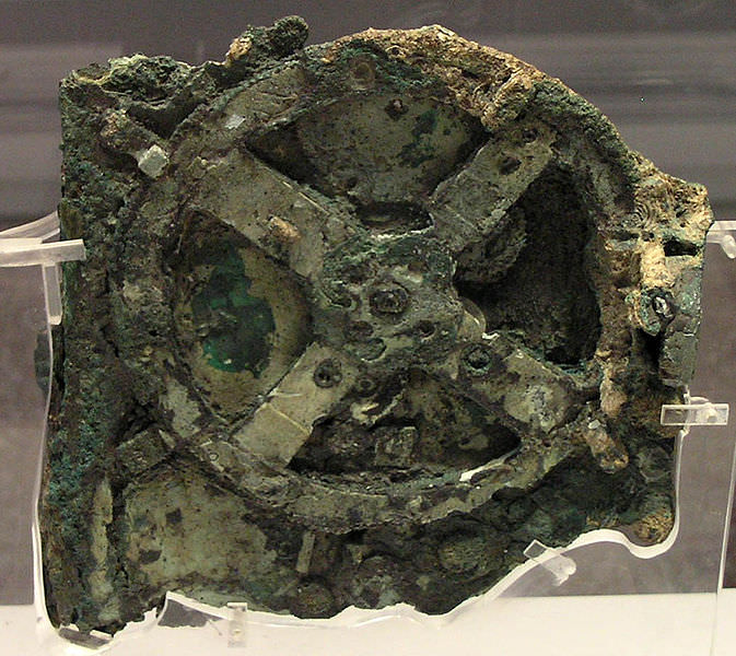
Antikythera by Marsyas via Wikimedia Commons

[/caption]

Leonardo da Vinci may have left behind sketches of helicopters, tanks and submarines but it is rare that we find actual artifacts that seem so way ahead of their time. Almost like a science fiction tale of archaeologists finding a wristwatch buried deep in an Egyptian pyramid or motorcar under the foundations of Stonehenge, we do have an example of a scientific computer that was built between 150 and 100 BC. It was so advanced, nothing as complex would be developed again until the 14th century.

The Antikythera mechanism was lost to the world for centuries. The device was salvaged in 1900 from a ship that sank en route to Rome, in the 1st century BC, between Crete and the island of Antikythera in the Mediterranean. When one of the fragments was discovered to contain a bronze gear wheel, the idea that this was some kind of astronomical clock was dismissed as too fantastic an anachronism. It was not until 1951 that the investigation was picked up by a British science historian Derek J. de Solla Price. So far 82 fragments have been recovered of what is now considered the oldest known astronomical computer.

The device is made of bronze and contains 30 gears though it may have had as many as 72 originally. Each gear was meticulously hand cut with between 15 and 223 triangular teeth, which were the key to discovering the mechanism’s various functions. It was based on theories of astronomy and mathematics developed by Greek astronomers who may have drawn from earlier Babylonian astronomical theories and its construction could be attributed to the astronomer Hipparchus or, more likely, Archimedes the famous Greek mathematician, physicist, engineer, inventor and astronomer. Why it was built, or for whom is unknown.
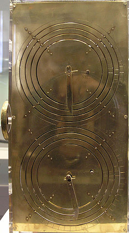
Replica Antikythera Based on the research of Professor Derek de Solla Price, in collaboration with the National Scientific Research Center Demokritos and physicist CH Karakalos. image by Marsyas via Wikimedia Commons

The main front dial showed the 365 day Egyptian year and the Greek signs of the Zodiac and could be adjusted to compensate for the extra quarter day in the solar year. The dial probably bore three hands that marked the date and positions of the Sun and Moon, while a separate mechanism showed the Moon’s phases and it likely also displayed the 5 classically known planets, Mercury, Mars, Venus, Jupiter and Saturn.

On the back an upper dial showed 19 year Metonic cycle of Moon phases, the 76 year Callippic cycle (four Metonic cycles) and calculated the 4 year Olympic cycle (four games took place in two and four year cycles) The lower dial showed the 18 year 11 days Saros eclipse cycle and the 54 year 33 day Exeligmos or triple saros cycle. It was driven by a hand crank now sadly lost. It is small, compact and portable with full instructions engraved upon it in Greek, about 95% of which have now been deciphered.

The fragile pieces that remain have been examined and modeled using high-resolution X-ray tomography and gamma rays and various reconstructions and replicas have been built. It has even had a working model constructed out of Lego. I can’t helping thinking that Archimedes would have rather liked Lego, if only we could go back in time and give him a set…

Find out more at the  Antikythera Mechanism Research Project

Book Review: The Final Journey of the Saturn V

Book review by David L. Hamilton

The Final Journey of the Saturn V, by Andrew R. Thomas and Paul N. Thomarios is a good book to add to this summer’s reading list. The nontechnical person should not be deterred by the title since the majority of the book covers the history of the rocket and the space race while the final chapter covers some of the details about the restoration process of the deteriorated Saturn V that weathered outside of Kennedy Space Center Florida for over a decade.

The authors do a great job explaining that during the Cold War the Soviet Union started to surpass the United States in in terms of rocketry and space exploration. For example, the Soviets launched the first satellite into Earth orbit, sent a probe to the Moon, launched the first rocket carrying a man that orbited the Earth, launched the first rocket carrying a woman that orbited the Earth and launched a rocket carrying the first man that walked in space.
All these first by the Soviets had a profound effect on Americans who finally realized that if the United States was going to have an influence in space exploration, they needed to get busy. And busy they got.

After a challenge from President Kennedy to put a man on the Moon and safely return him before the end of the 1960’s and a cash infusion from the United States government, NASA expanded operations that employed over 400,000 individuals who worked for NASA and its many subcontractors. The Saturn V rockets that would take over a dozen men to the moon and launch Skylab into orbit is the end result of the money, manpower and determination that drove the United States of America to take the lead in the space race after the slow start and second place status it held for several years.

Sadly, after making it to the moon several times the public grew tired of NASA and the Moon missions so funding for NASA dried up. Jobs were lost and equipment was neglected and misplaced. Locating and restoring the equipment and preserving it for future generations is covered in the last chapter.

Authors Thomas and Thomarios do a great job of keeping the book nontechnical so that the causal reader who has no science background can easily understand and enjoy it while keeping it interesting enough for the more experienced reader who specializes in the history of space flight.

A real plus for this book is an impressive foreword written by Captain Gene Cernan, Commander of Apollo 17 and the last man to have walked on the Moon. In addition to the foreword, there are many unique photographs ranging from those that made the Moon landings possible to the equipment involved and those in charge of restoring the Saturn V for our future generations.

See more information about the book at the University of Akron Press webpage.

Reviewer David Hamilton and his wife live in Conway, Arkansas. They are amateur astronomers that love spending nights stargazing. David is an Educational Technologist and a multidisciplinary researcher currently attending the University of Arkansas at Little as a graduate student. David is an alumni of the University of Oklahoma and Rose State College.

Shuttle Enterprise Lands on the Deck of Intrepid in Manhattan

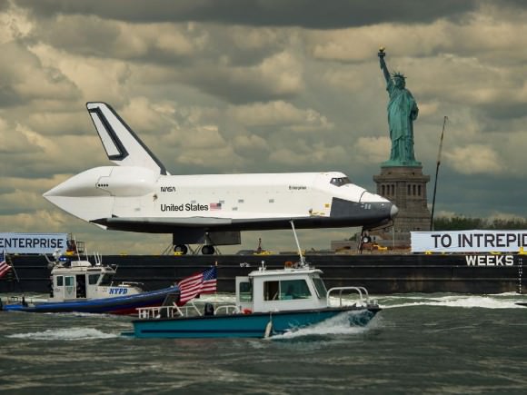
NASA’s Space Shuttle Enterprise lowered by crane onto the deck of the Intrepid on June 6, 2012. After transiting the NYC Skyline on a barge on June 3 and June 6, Enterprise arrive at her permanent new home and was hoisted onto the flight deck of the Intrepid Sea, Air and Space Museum. Credit: Ken Kremer

[/caption]
NASA’s Space Shuttle Enterprise magnificently completed her final mission by making a historic landing on the deck of a retired aircraft carrier berthed in Manhattan- the Intrepid – as the first and only space shuttle to ever do so on a once-in-history spectacle befitting the Big Apple.

But instead of a piloted landing by air, Enterprise arrived afloat, atop a seagoing barge and was then hoisted and gently lowered for touch down on top of the Intrepid’s flight deck by a humongous seagoing crane accompanying the shuttle on a second barge at 4 p.m. EDT on Wednesday, June 6.

The Intrepid Sea, Air and Space Museum is the permanent new home of the Enterprise, NASA’s prototype shuttle – built in 1976 – that was used for a series of critical atmospheric approach and landing tests in the late 1970’s and that paved the way for building all the five shuttle orbiters that followed and the first launch by the Columbia in April 1981.

Enterprise transits the NYC skyline and the Empire State Building and arrives by barge at the Intrepid on June 6, 2012. Enterprise was then hoisted onto the flight deck of the Intrepid Sea, Air and Space Museum. Credit: Ken Kremer

Enterprise embarked on a long and winding road to reach the Intrepid which I witnessed at points along the way. First she flew piggyback on top of NASA’s specially modified 747 Jumbo Jet from Dulles International Airport for a triumphant fly over tour of the New York Metropolitan region on April 27 before touching down at John F. Kennedy (JFK) International Airport.

Enterprise had been on public display at the Smithsonian’s National Air & Space Museum Annex in Virginia since 2003.

Then the shuttle took a two day cruise on June 3 and June 6, towed by a tugboat; departing from JFK on June 3 and voyaging through New York Harbor to the Statue of Liberty before making an intermediate stop at a port in Bayonne, New Jersey to switch to another larger barge. Along the way the orbiter suffered some minor damage to the right wing tip when wind gusts caused her to scrape against a railroad bridge.

After a 24 hour postponement due to poor weather, a repaired shuttle Enterprise at last put out to sea again on Wednesday morning, June 6, at about 9:45 a.m. for the very last time on the final leg of her thrilling final voyage.

A giant Weeks Marine crane hoist Enterprise off the barge and onto the flight deck of the Intrepid Sea, Air and Space Museum on June 6, 2012. Credit: Ken Kremer

Enterprise took one last beauty ride past the Statue of Liberty, Ground Zero and the Freedom Tower before sailing North up the Hudson River and past the Empire State Building on Manhattan’s West Side; enjoyed by throngs of onlookers and space enthusiasts lining the shores of New York and New Jersey.

She arrived at the Intrepid, located at Pier 86 at 46th Street and 12th Avenue, at about 1 p.m. accompanied by a flotillia of police and water spraying fire boats, ferries , sailboats and pleasure craft.

The giant lifting crane was maneuvered into position in between the Intrepid and Enterprise.

Over the next three hours, technicians carefully attached a yellow steel harness sling to the 150,000 pound orbiter at four points, two in the front and two in the rear. This was the same sling used to lift Enterprise onto and off the back of the 747 jet.

The 240 foot crane used to hoist Enterprise is the same one used to lift the US Airways jet piloted by hero captain Chesley “Sully” Sullenberger out of the Hudson after an emergency water landing near the same exact spot in January 2009 – where all the passengers and crew on board miraculously survived.

Sailing by Statue of Liberty on June 6, 2012. The space shuttle Enterprise, atop a barge, passes the Statue of Liberty in New York on its way to the Intrepid Sea, Air and Space Museum where it will be permanently displayed. Photo Credit: NASA/Bill Ingalls

The dramatic pluck of the 75 ton Enterprise off the Weeks Marine barge started around 3:45 p.m. as the winds were gently gusting. Enterprise was raised some 75 feet and rotated nearly 180 degrees so her nose faced directly towards the Hudson River and the beautiful city and cliffs of Weehauken, in Hudson County, New Jersey, where I was watching and photographing from. Enterprise came to rest with wheels down around 4:02 p.m., pretty much exactly on time.

Finally the yellow sling was detached around 6 p.m. and Enterprise was dramatically exposed on the deck of the Intrepid in a beautiful sight for all to see.

But that gorgeous deck view didn’t last long because the museum quickly covered Enterprise with an inflatable pavilion to protect the delicate and precious orbiter from the weather and flying debris – and gawkers looking for free.

To see the Enterprise in all her glory now, you’ll have to pay $22 for admission to the museum and an extra $6 for the shuttle – or check my deck top photo below.

Dramatic rare view of exposed Enterprise at rest on the flight deck of the Intrepid - hoisting sling removed after June 6 landing. Soon thereafter the shuttle was covered with a temporary inflatable pavilion for protection - and no open view. Nose faces exactly to Weehauken, New Jersey. Credit: Ken Kremer

The museum is hastily constructing a temporary, climate controlled “Space Shuttle Pavilion” to house Enterprise. She will be open for public display starting on July 19.

Enterprise is named after the fictional starship in the world renowned and beloved TV science fiction series – “Star Trek”.

Ken Kremer

Dang, These Features on Mars are Groovy!

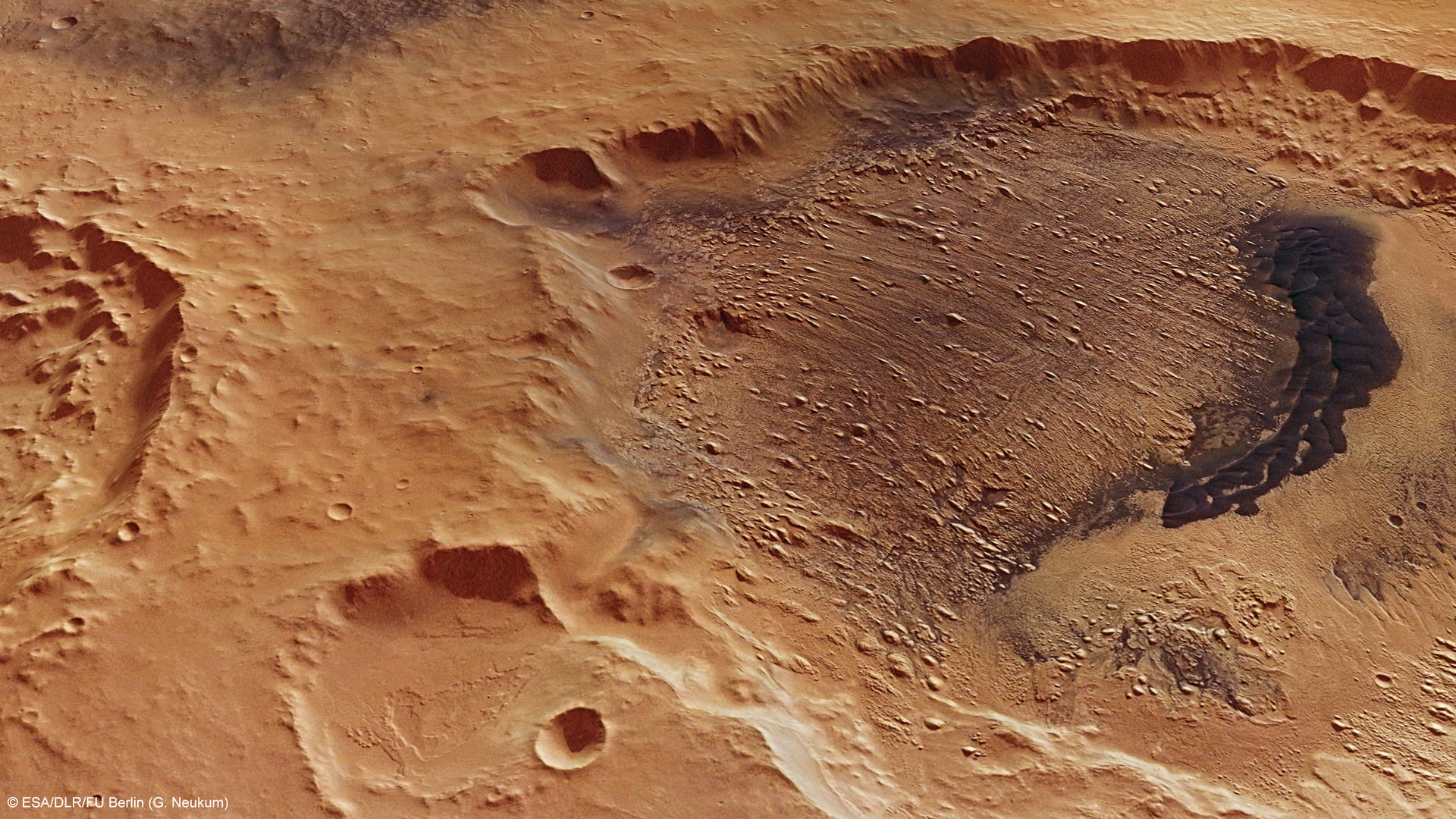
This computer-generated view of the yardangs in Danielson Crater on Mars was created using data obtained from the High- Resolution Stereo Camera (HRSC) on ESA’s Mars Express. Credit: ESA/DLR/FU Berlin (G. Neukum)

[/caption]

The term ‘yardangs’ almost sounds like a fictional word from a Barsoomian tale of creatures living on Mars. However, this is a real word, a geologists’ term for narrow, wind-eroded ridges. These are common land features in the desert regions of Earth, eolian features created by wind and dust. With Mars’ dusty soil and frequent winds, these landforms are common on the Red Planet, too. The abrasive dust is blown by wind, impacting on the bedrock, slowly removing parts of the surface, like a sand-blaster. If the winds blow in the same direction for a long enough period, ‘wind-lanes’ are made. These features are called yardangs.

These latest images from the Mars Express mission show yardangs on the floor of Danielson crater, and scientists think this crater may provide evidence that the planet underwent significant periodic fluctuations in its climate due to changes in its rotation axis.

On June 19, 2011, Mars Express took a look at the region pictured here — Arabia Terra region of Mars — imaging Danielson and the smaller Kalocsa crater with its high-resolution stereo camera.

In the case of Danielson crater, scientists think the sediments were cemented in by water, possibly from an ancient deep groundwater reservoir, before being eroded by the wind.

Danielson and Kalocsa craters as seen by Mars Express. Credit: ESA/DLR/FU Berlin (G. Neukum)

The orientation of the yardangs leads scientists to theorize that strong north–northeasterly winds (from the lower right in the image) both deposited the original sediments and then caused their subsequent erosion in a later drier period of Martian history.

A 30 km-long field of darker dunes can be seen bisecting the yardangs and is thought to have formed at a later epoch.

Some scientists believe that this indicates periodic fluctuations in the climate of Mars, triggered by regular changes in the planet’s axis of rotation. The different layers would have been laid down during different epochs.

But Kalocsa crater shows a completely different topography, with no layered sediments. This is thought to be due to the higher altitude of its floor, with the crater not tapping in to the suspected underlying ancient water reservoir.

However, another hypothesis is that this crater is younger than its neighbor, created when water was not present anymore.

Dang.

Source: ESA

Weekly Space Hangout – June 7, 2012

In this week’s episode of the Weekly Space Hangout, Universe Today’s Fraser Cain is joined by Alan Boyle from MSNBC and Amy Shira Teitel from Vintage Space.

They discussed:

  • The 2012 Transit of Venus
  • The space shuttle Enterprise’s final journey to a museum.
  • NASA’s new plans for commercializing space
  • A quick review of the new movie Prometheus

We record the Weekly Space Hangout live every Thursday at 10 am Pacific/ 1 pm Eastern. Watch us record the show live on Google+ every week. The show is also broadcast live over on Cosmoquest.

Mars Rover Drivers Inspired by Ray Bradbury

Two of the drivers of the Mars Exploration Rovers, Ashley Stroupe and Scott Maxwell, were fortunate to host a very special visitor to the Jet Propulsion Laboratory a couple of years ago. Science fiction author Ray Bradbury came, and even though he was wheel-chair-bound, he received the grand tour, and the two rover drivers showed him huge panoramic images taken by the rovers and even let Bradbury drive a 3-D computer model of the rovers. Stroupe tells the story of Bradbury’s visit in the video above, and Maxwell told his version of the story in a blog post back in 2009, which was re-published on the Planetary Blog. Of Bradbury seeing the panoramas, Maxwell wrote, “These just happen to be perfect for Bradbury: color panoramic images of Mars, taken from a human’s perspective, but mounted close to a wheelchair-bound man’s height. It must have seemed to him that he was, for the first time, really there. On the edge of a crater. On top of a mountain. On the plains, looking at the crashed remnants of the spaceship we rode there. On Mars.”
Continue reading “Mars Rover Drivers Inspired by Ray Bradbury”

Unexpected Find: ‘Rainforest’ of Phytoplankton Growth in the Arctic Ocean

Don Perovich, part of the ICESCAPE mission used a spectroradiometer to measure the amount of sunlight reflected from the surface of ice and melt ponds in the Chukchi Sea. Credit: NASA/Kathryn Hansen

[/caption]

Imagine finding a rainforest in the middle of a desert. That is how NASA scientists are equating a new biological discovery in Arctic Ocean. Microscopic plants called phytoplankton are actively growing under the thinning Arctic ice. In fact, the scientists say the phytoplankton growth in the Arctic may now be richer than any other ocean region on Earth. The finding reveals a new consequence of the Arctic’s warming climate, and gives researchers an important clue to understanding the impacts of a changing climate and environment on the Arctic Ocean and its ecology.

“If someone had asked me before the expedition whether we would see under-ice blooms, I would have told them it was impossible,” said Kevin Arrigo of Stanford University, leader of the ICESCAPE mission and lead author of the new study. “This discovery was a complete surprise.”

ICESCAPE, stand for Impacts of Climate on EcoSystems and Chemistry of the Arctic Pacific Environment and in 2010 and 2011, scientists explored Arctic waters in the Beaufort and Chukchi seas along Alaska’s western and northern coasts onboard a U.S. Coast Guard icebreaker. The researchers drilled down through three-foot thick sea ice to study impacts of environmental variability and change in the Arctic on the ocean biology, ecology and biogeochemistry.

The researchers found the phytoplankton were extremely active, doubling in number more than once a day. Conversely, blooms in open waters grow at a much slower rate, doubling in two to three days. These growth rates are among the highest ever measured for polar waters.

Phytoplankton were thought to grow in the Arctic Ocean only after sea ice had retreated for the summer.

In July of 2011 the researchers observed blooms beneath the ice that extended from the sea-ice edge to 72 miles into the ice pack. Ocean current data revealed that these blooms developed under the ice and had not drifted there from open water, where phytoplankton concentrations can be high.

Previously, it was thought that sea ice blocked most sunlight needed for phytoplankton growth. Scientists now think that the thinning Arctic ice is allowing sunlight to reach the waters under the sea ice, spurring plant blooms where they had never been observed. The findings were published today in the journal Science.

Phytoplankton is the base of the marine food chain and they consume large amounts of carbon dioxide. Scientists will have to reassess the amount of carbon dioxide entering the Arctic Ocean through biological activity if the under-ice blooms turn out to be common.

“At this point we don’t know whether these rich phytoplankton blooms have been happening in the Arctic for a long time and we just haven’t observed them before,” Arrigo said. “These blooms could become more widespread in the future, however, if the Arctic sea ice cover continues to thin.”

The discovery of these previously unknown under-ice blooms also has implications for the broader Arctic ecosystem, including migratory species such as whales and birds. Phytoplankton are eaten by small ocean animals, which are eaten by larger fish and ocean animals. A change in the timeline of the blooms can cause disruptions for larger animals that feed either on phytoplankton or on the creatures that eat these microorganisms.

“It could make it harder and harder for migratory species to time their life cycles to be in the Arctic when the bloom is at its peak,” Arrigo said. “If their food supply is coming earlier, they might be missing the boat.”

The scientists said the discovery also may have major implications for the global carbon cycle and the ocean’s energy balance, and they may need to revise their understanding of the ecology of the Arctic and the region’s role in the Earth system.

You can see more images from the ICESCAPE expedition on NASA Goddard’s Flickr page.

The team’s paper: K.R. Arrigo et al. Massive phytoplankton blooms under Arctic sea ice. Science. doi:10.1126/science.1215065.

Source: NASA

Spitzer Captures Ancient Fireworks of First Objects in the Universe

These two panels show the same slice of sky in the constellation Boötes, dubbed the "Extended Groth Strip." The area covered is about 1 by 0.12 degrees. Image credit: NASA/JPL-Caltech/GSFC

[/caption]

The Spitzer Space Telescope has looked back in time to see what scientists called the “faint, lumpy glow” given off by the very first objects in the Universe, and these ancient objects obviously provided some early cosmic fireworks. While they are too faint and distant to figure out what the individual objects are – they may be massive stars or voracious black holes – Spitzer has captured what appears to be the collective pattern of their infrared light, revealing these first objects were numerous and furiously burned cosmic fuel.

“These objects would have been tremendously bright,” said Alexander “Sasha” Kashlinsky from the Goddard Space Flight Center, lead author of a new paper appearing in The Astrophysical Journal. “We can’t yet directly rule out mysterious sources for this light that could be coming from our nearby universe, but it is now becoming increasingly likely that we are catching a glimpse of an ancient epoch. Spitzer is laying down a roadmap for NASA’s upcoming James Webb Telescope, which will tell us exactly what and where these first objects were.”

This isn’t the first time astronomers have used Spitzer to search for the very first stars and black holes, and back in 2005 they saw hints of this remote pattern of light, known as the cosmic infrared background, and again with more precision in 2007. Now, Spitzer is in the extended phase of its mission, during which it performs more in-depth studies on specific patches of the sky. Kashlinsky and his colleagues used Spitzer to look at two patches of sky for more than 400 hours each.

The team then carefully subtracted all the known stars and galaxies in the images. Rather than being left with a black, empty patch of sky, they found faint patterns of light with several telltale characteristics of the cosmic infrared background. The lumps in the pattern observed are consistent with the way the very distant objects are thought to be clustered together.

Kashlinsky likens the observations to looking for Fourth of July fireworks in New York City from Los Angeles. First, you would have to remove all the foreground lights between the two cities, as well as the blazing lights of New York City itself. You ultimately would be left with a fuzzy map of how the fireworks are distributed, but they would still be too distant to make out individually.

“We can gather clues from the light of the Universe’s first fireworks,” said Kashlinsky. “This is teaching us that the sources, or the “sparks,” are intensely burning their nuclear fuel.”

The Universe formed roughly 13.7 billion years ago in a fiery, explosive Big Bang. With time, it cooled and, by around 500 million years later, the first stars, galaxies and black holes began to take shape. Astronomers say some of that “first light” might have traveled billions of years to reach the Spitzer Space Telescope. The light would have originated at visible or even ultraviolet wavelengths and then, because of the expansion of the universe, stretched out to the longer, infrared wavelengths observed by Spitzer.

The new study improves on previous observations by measuring this cosmic infrared background out to scales equivalent to two full moons — significantly larger than what was detected before. Imagine trying to find a pattern in the noise in an old-fashioned television set by looking at just a small piece of the screen. It would be hard to know for certain if a suspected pattern was real. By observing a larger section of the screen, you would be able to resolve both small- and large-scale patterns, further confirming your initial suspicion.

Likewise, astronomers using Spitzer have increased the amount of sky examined to obtain more definitive evidence of the cosmic infrared background. The researchers plan to explore more patches of sky in the future to gather more clues hidden in the light of this ancient era.

“This is one of the reasons we are building the James Webb Space Telescope,” said Glenn Wahlgren, Spitzer program scientist at NASA Headquarters in Washington. “Spitzer is giving us tantalizing clues, but James Webb will tell us what really lies at the era where stars first ignited.”

Read the team’s paper.
Source: NASA

Thierry Legault: One Transit is Not Enough

The transit of the Hubble Space Telescope across the Sun was taken from Queensland, Australia, simultaneously with the 2012 transit of Venus. Credit: Thierry Legault.

[/caption]

Astrophotographer Thierry Legault had told us he was traveling to Australia for the Transit of Venus, so we knew he had something special planned. But that still didn’t prepare us for the awesomeness of what he has just achieved. During the Transit of Venus, Legault also captured the Hubble Space Telescope moving across the face of the Sun. Not once, but 9 times, during the HST’s transit time of .97 seconds. “Thanks to the continuous shooting mode of the Nikon D4 DSLR running at 10 fps,” Legault said on his website, which shows his new images. Of course, due to the differences in distance from Earth of Hubble vs. Venus, Venus took a lazy 6-plus hours to make its transit. A few giant sunspots also join in the view.

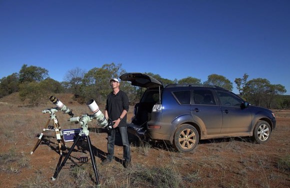
Below see a close-up of the two transits and a look at Legault’s set-up in the Outback of Queensland.

A close-up of Venus and Hubble (tiny black dots just above Venus) transiting the Sun. Credit: Thierry Legault. Used by permission.
Legault's equipment setup for viewing the Venus Transit in Queensland, Australia. Credit: Thierry Legault. Used by permission.

Legault noted that just one of the telescope/camera setups was his. So, he had just one chance of capturing the double transit. And he nailed it.

Here’s the map from CalSky of where the HST transit would be visible, just a thin band across the top of Queensland:

Map from CalSky of the Hubble Transit. Via Thierry Legault.

Legault said he has some more images on the way, including the ring of the atmosphere of Venus around the first contact, images of the transit in H-alpha, and the full ring of Venus 24 hours after the transit, so keep checking his website for more fantastic images.

Congratulations to Thierry Legault for a truly amazing and special capture of the Transit of Venus, something that won’t happen again in our lifetimes. And thanks to Thierry for sharing his images with Universe Today.

Vesta’s Amazing Technicolor Surface

A brand new 3-D video map from the Dawn mission provides a unique view of the varied surface of the giant asteroid Vesta. The animation drapes high-resolution false color images over a 3-D model of the Vesta terrain constructed from Dawn’s observations. This visualization enables a detailed view of the variation in the material properties of Vesta in the context of its topography.
Continue reading “Vesta’s Amazing Technicolor Surface”