
I was traveling the day this video was released, so missed posting it earlier. If you haven’t seen it yet, this animation of ocean surface currents is just mesmerizing. It shows ocean currents from June 2005 to December 2007, created with data from NASA satellites. In the video you can see how bigger currents like the Gulf Stream in the Atlantic Ocean and the Kuroshio in the Pacific carry warm waters across thousands of kilometers at speeds greater than six kilometers per hour 4 mph), as well as seeing how thousands of other ocean create slow-moving, circular pools called eddies. The entire visualization is reminiscent of Vincent Van Gogh’s “Starry Night” painting.
Continue reading “Earth’s Van Gogh Oceans”
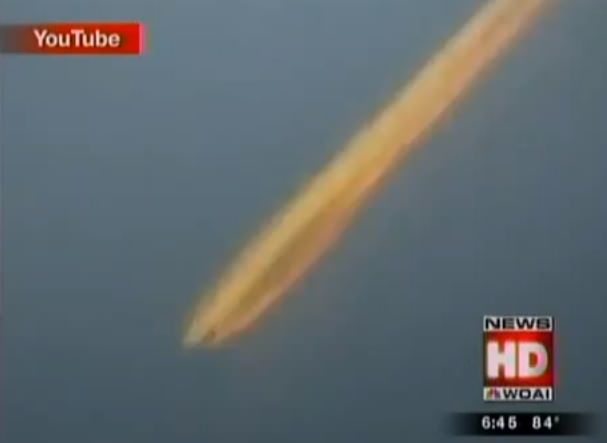
Is This a Video of a Huge Fireball Over Texas?
[/caption]
On April 2, 2012, at around 11:50 am CDT, dozens of people in and around San Antonio, Texas witnessed a bright object streaking across the daytime sky. Most likely a fireball — a particularly large, bright meteor — the object was visible across a very large area. It even made the local WOAI4 NBC news, which sent reporters out to interview eye-witnesses, contacted a NASA meteor expert, and ultimately featured a video of the amazingly bright fireball as it blazed through the sky. Very dramatic.
Except… the video isn’t of a fireball at all.
For the record, there was a meteor spotted over San Antonio on April 2… it was reported on the Lunar Meteorite Hunters site as well as in local papers. The eyewitnesses in the WOAI video were indeed describing what they saw, as well as they could. But the “footage” that was revealed later in the video wasn’t of a meteor; rather, it was something much more terrestrial.
It appears to be an airplane contrail, illuminated by sunlight.
Unfortunately this didn’t stop the segment from airing on TV, or from being picked up by syndicated news over a week later to appear on several online news sites.
At first glance the video does appear to show something fiery descending from the sky, leaving a long, bright trail in its wake. But that’s exactly how contrails can look when lit up by low-angle sunlight. It’s not necessarily a common sight to most people, but it’s common enough that those who have seen it would recognize that the video was, for lack of a better term, inaccurate. And inaccuracies can all-too-easily spread into a fire of misinformation — especially when concerning “things from the sky”.

Experienced pilot Mick West describes the phenomenon on his blog ContrailScience.com:
“This is a remarkably common news story: It’s just after sunset, someone looks towards the west and they see the short contrail of a jet plane illuminated by the sun. It looks red, like fire. They zoom in with their video camera. They don’t know what it is, thinking it’s a fireball, a meteor, or some kind of UFO, so they alert the local media. The local media published it, and occasionally the story grows.”
(Read Mick’s post “Short Sunlit Contrails Look Like UFOs”)
Even though the April 2 fireball wasn’t seen at sunset or sunrise, the video footage wasn’t from the actual event. This means not only is it not of a meteor it’s not even from the right time of day. One has to wonder where in fact it was actually shot from, and by whom.
I don’t know if the contrail footage was sent in to the news channel intentionally, or if it was just an error due to lack of research. Regardless, it’s a good example of why facts and sources need to be checked!
Luckily there are those who know a contrail from a meteor, and thanks to the miracle of modern social networking such information discrepancies can be rectified in short order.
Hat-tip to Daniel Fischer at Cosmos4U.
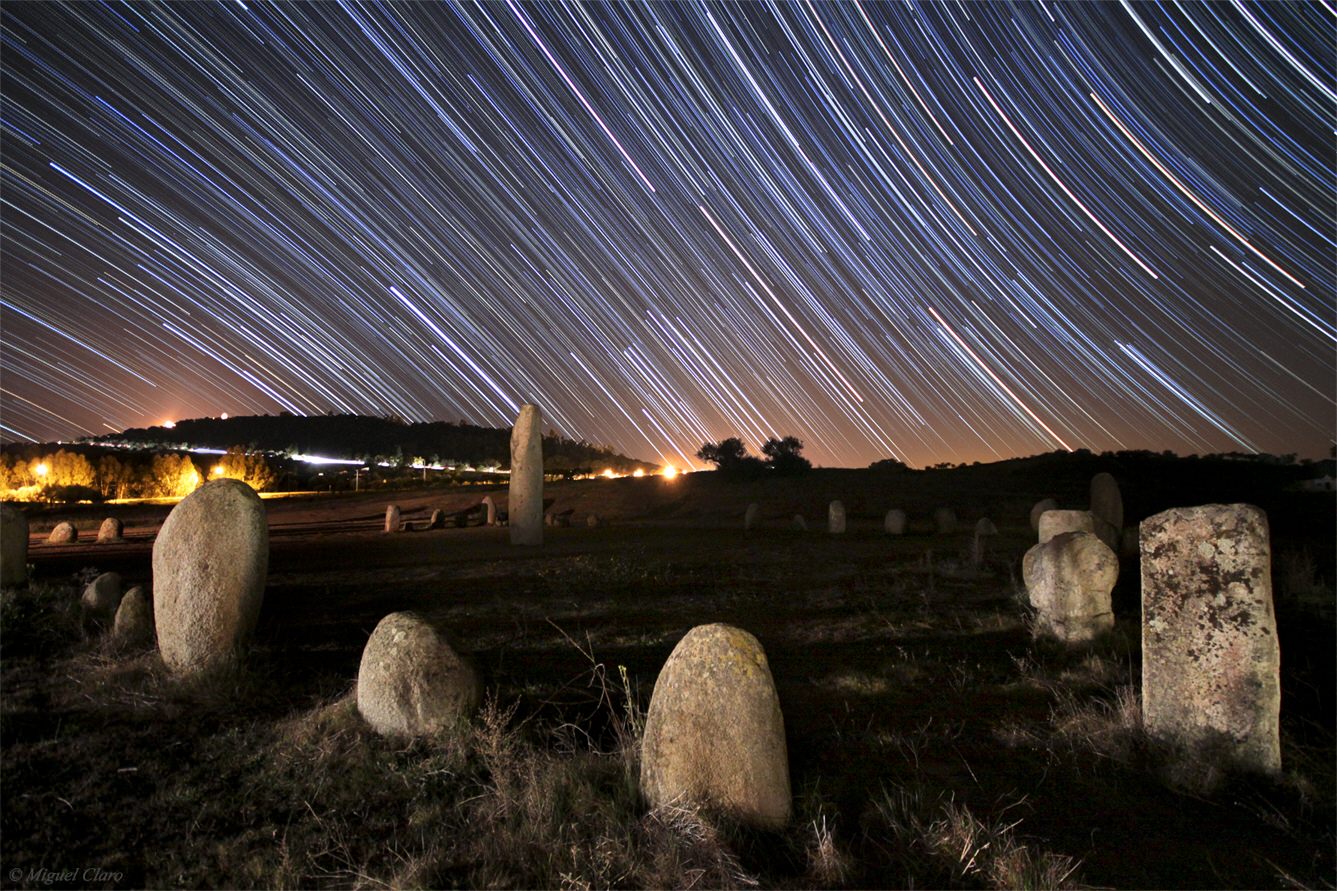
Alqueva: Some of the Darkest, Clearest Skies on Earth
[/caption]
It’s a place with dark skies, clear nights and ancient astronomical megaliths. What more could you want in an astro-destination? The Great Lake Alqueva Dark Sky Reserve in Portugal is the first site in the world to receive the “Starlight Tourism Destination” certification and has good atmospheric conditions for stargazing for more than 250 nights of the year, as well as having special lodging just for astro-tourists. The services for guests include late night meals and meals to go for stargazers, available telescopes and binoculars, and classes on astronomy and observing.
Astrophotographer Miguel Claro was tasked with having just two nights to take images of one part of this Dark Sky Reserve to help promote the region, and he has sent Universe Today his stunning images. “They are representative of the Monsaraz region, one of the locations covered by the Dark Sky Reserve area and that had the best dark sky measures in the process of Starlight validation,” Claro told UT. “Even being so dark, and without the presence of the Moon to light up the landscape – at this time of the year without the major presence Milky Way – I had to use very high ISO´s, so there were some differences between heaven and Earth elements, avoiding overly dark images. But the sky was so dark, that we could find M33 with unaided eye.”
Enjoy several of Claro’s images below, as well as finding out more about this dark sky destination.


The Alqueva Dark Sky Reserve is coordinated by Genuineland in partnership with the Tourism Lands of the Great Lake Alqueva, the Alentejo Coordination and Regional Development Commission and EDIA, SA and with the collaboration of APAA – Portuguese Association of Amateurs Astronomers- through Dr. Guilherme de Almeida and Eng. Vitor Quinta, as well with external participation of Dr. Raul Lima, for the sky measurements that were made during the certification process.
For more information about the Lake Alqueva Dark Sky Reserve see this website. Enjoy more of Miguel Claro’s images at his website.
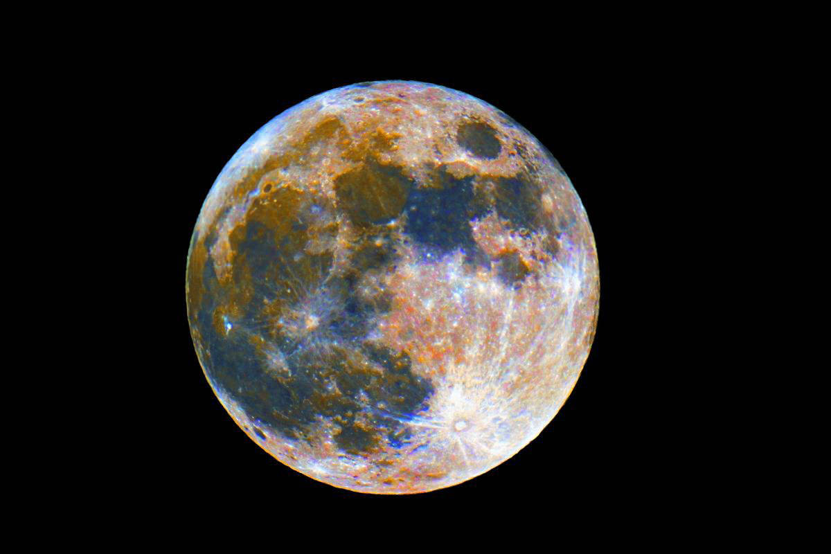
Astrophotos: A Colorful Moon
[/caption]
Recognize this? Yes, it is our own Moon, but using Photoshop, the photographer, César Cantú from the Chilidog Observatory in Monterrey, Mexico extracted the Moon’s colors and exaggerated them just a bit. “Although exaggerated, the color components are the real highlights,” César said, “with blue indicating a significant amount of titanium, and the orange areas with little iron or titanium. These colorful images are more easy to perform That thanks to digital cameras that detect colors — where with analog cameras, it is still impossible.”
César took the image on April 6, 2012. See his website for more details.
Want to get your astrophoto featured on Universe Today? Join our Flickr group, post in our Forum or send us your images by email (this means you’re giving us permission to post them). Please explain what’s in the picture, when you took it, the equipment you used, etc.
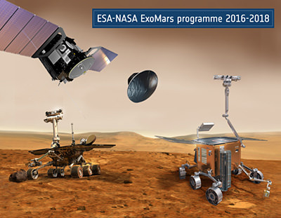
Will Russia Rescue ExoMars?
[/caption]
After NASA was forced to back out the joint ExoMars mission with the European Space Agency due to budget constraints, ESA went looking for help with the planned multi-vehicle Mars mission. Now, reportedly the Head of Roscosmos Vladimir Popovkin met with Director General of the ESA, Jean-Jacques Dordain last week, and the two signed a memorandum of understanding to work together to make ExoMars a reality.
“The sides consider this project feasible and promising,” Popovkin’s spokeswoman Anna Vedishcheva was quoted in Ria Novosti. “The sides are to sign the deal by year-end.”
Russia’s participation in the project was also approved by the space council of the Russian Academy of Sciences.
The ExoMars program was slated to send an orbiter to Mars in 2016 and a rover in 2018, but after NASA pulled out of its part of the bargain — of providing several science instruments and an Atlas launch vehicle – ESA knew they could not do the entire mission on their own. Last fall, when it was becoming apparent that NASA’s ability to participate was in jeopardy, Dordain extended an invitation to Russia, and in turn Roscosmos officials hinted they might be interested in joining, offering to provide the use of their Proton rockets for the launches. The two space agencies then had preliminary talks at the Ariane 5 launch at Kourou, French Guiana in March, 2012.
Russian space agency chief Vladimir Popovkin said that Russia’s financing of ExoMars could be partially covered by insurance payments of 1.2 billion rubles (about $40.7 million) for the lost Phobos-Grunt sample return mission that would have gone to the Martian moon Phobos.

The details of the new ExoMars partnership are yet to be worked out, but the ESA/NASA partnership would have sent the Trace Gas Orbiter to the Red Planet in 2016 to search for atmospheric methane — a potential signature for microbial life – as well as an advanced astrobiology rover to drill into the surface in 2018, with the hopes of determining if life ever evolved on Mars.
Unsurprisingly, the potential deal with Russia comes as a huge relief to European space scientists who have spent years working on ExoMars. Journalist Paul Sutherland quoted UK scientist John Zarnecki of the Open University, as saying, “It looks like the cavalry has come riding over the horizon to save us, but this time they are dressed in Russian uniforms. There will be a lot scientists in universities and research institutes throughout Europe who will be very relieved to hear this news. Otherwise it seemed that several years work preparing instruments for this mission was going to go down the drain.”
Sources: Sen.com, Ria Novosti
Drop Test for Orion Crew Capsule’s New Parachutes
NASA successfully conducted a drop test of the Orion crew vehicle’s entry, descent and landing parachutes in preparation for the vehicle’s first orbital flight test, currently scheduled for 2014. Orion is the crew vehicle that NASA is building to bring astronauts to new destinations in space. It will be launched on the new rocket being built, the Space Launch System. Unlike the space shuttle, Orion will have emergency abort capability, and won’t be landing on a runway. Instead, the vehicle will splash down in the ocean, like the US capsules in the 1960’s and 70’s. NASA is working to make sure the crews will have a safe re-entry and landing, and the parachute tests help to ensure that.
Continue reading “Drop Test for Orion Crew Capsule’s New Parachutes”
Carnival of Space #244
[/caption]
This week’s Carnival of Space is hosted by Brian Wang at Next Big Future.
Click here to read Carnival of Space #244.
And if you’re interested in looking back, here’s an archive to all the past Carnivals of Space. If you’ve got a space-related blog, you should really join the carnival. Just email an entry to [email protected], and the next host will link to it. It will help get awareness out there about your writing, help you meet others in the space community – and community is what blogging is all about. And if you really want to help out, sign up to be a host. Send an email to the above address.
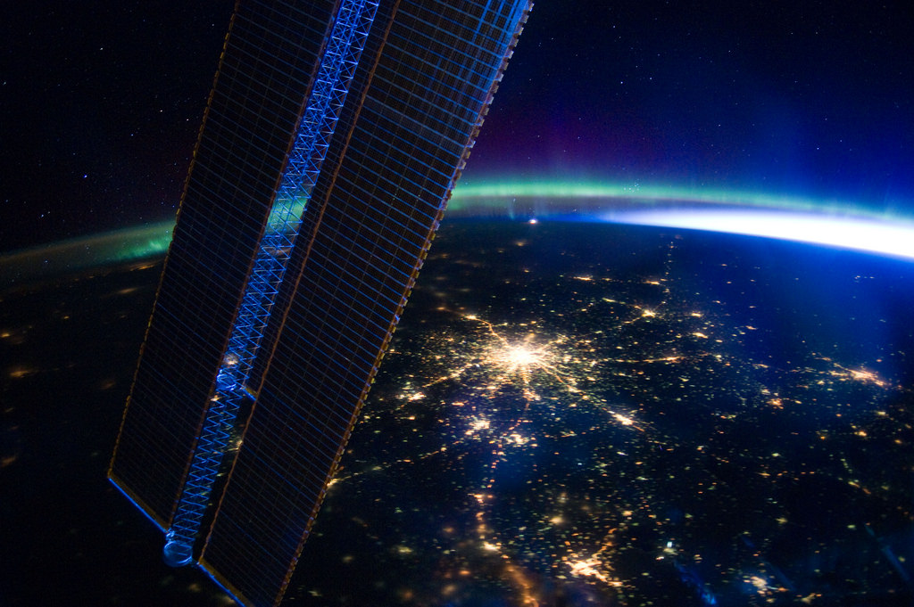
Moscow At Night
[/caption]
Tracing a bright star upon the Earth, the lights of Russia’s capital city blaze beyond the solar panels of the International Space Station in this photo, captured by the Expedition 30 crew on the night of March 28, 2012.
As an electric-blue dawn flares around Earth’s northeastern limb, the green and purple fire of the Aurora Borealis shimmers and stretches away to the northwest above a pale yellow line of airglow.
Traveling at 17,500 miles an hour (28,163 km/hr), the ISS was approximately 240 miles (386 km) above the Russian city of Volgograd (formerly Stalingrad) when this photo was taken.
Image: NASA
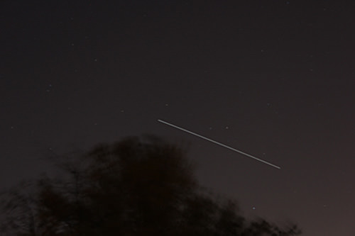
Great ISS Sightings – All Nights this Week of April 9
-
[/caption]
Calling all Skywatching and Space Fans ! This is a great week for observing the International Space Station (ISS), swiftly crossing the evening nighttime sky.
All this week from Monday thru Saturday, folks all across vast portions of the United States and Canada will be treated to fabulous viewings of the International Space Station. And at very convenient viewing times in the early evening, after dinner and in prime time.
From Maine to Vancouver, from Ohio to Texas, from Florida to New Mexico – many of you will be in for a rather pleasurable ISS treat.
Of course the exact viewing times, days, elevations, durations and directions varies greatly depending on your exact location – and clear skies. And the viewing parameters change daily.
Check out this NASA website for Human Spaceflight Sighting Opportunities. It’s simple. Just plug in your country, state and select a local town. Also check out – Heavens Above.
This evening, Monday April 9, I shot a few 20 to 30 second exposures as the ISS was speeding past at about a 30 degree elevation. But the best viewings at far higher elevations are yet to come the remainder of this week.
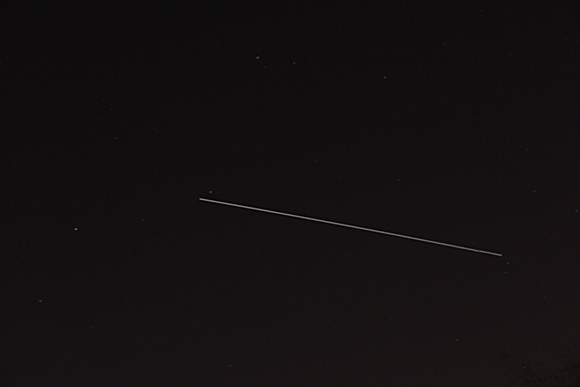
The International Space Station is the brightest manmade object in the night sky and even brighter than Venus depending on orbital mechanics. Only our Sun is brighter. Since Venus is an evening observing target this week, maybe you’ll even be lucky to see the ISS seem to pass close by that hellishly hot planet.
Have you ever looked at the ISS hurtling overhead ?
Take some shots and send them to Ken to post here at Universe Today.
And remember, 6 Humans from the US, Russia and the Netherlands are currently residing aboard the ISS, conducting science research and sending back gorgeous shots of all of us back here on Earth.
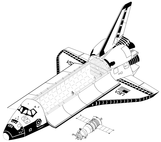
Shuttle vs. Soyuz
[/caption]
Here’s an interesting illustration showing the size comparison of a Space Shuttle to a Soyuz vehicle, shared on Twitter by NASA astronaut Rick Mastracchio (@AstroRM). Amazing to think that three flight-suited astronauts are able to fit inside a Soyuz and have life support for up to a month! (Although I’m sure most hope they won’t have to stay that long.)
Compare the 7-person capacity, 65.8 cubic meter crew cabin of an orbiter to the 3-person, 10 cubic meter space inside a Soyuz and one can imagine how cozy it must get during trips to and from the Station.
Rick is currently in training for a Soyuz flight to the ISS in November of next year as a member of the Expedition 38 crew, at which time he’ll get plenty of first-hand experience with the precise interior measurements of a Soyuz.
Thanks to Rick for sharing this! You can find out more about the Soyuz vehicles here, and check out the full source publication MIR Hardware Heritage (1995) by David S. F. Portree for Johnson Space Center.