Dawn swoops to lowest orbit around Vesta – Unveiling Spectacular Alien World

Dawn Orbiting Vesta. This artist's concept shows NASA's Dawn spacecraft orbiting the giant asteroid Vesta. The depiction of Vesta is based on images obtained by Dawn's framing cameras. Dawn is an international collaboration of the US, Germany and Italy. Credit: NASA/JPL-Caltech

[/caption]

NASA’s Dawn Asteroid Orbiter successfully spiraled down today to the closest orbit the probe will ever achieve around the giant asteroid Vesta, and has now begun critical science observations that will ultimately yield the mission’s highest resolution measurements of this spectacular body.

“What can be more exciting than to explore an alien world that until recently was virtually unknown!” Dr. Marc Rayman gushed in an exclusive interview with Universe Today. Rayman is Dawn’s Chief Engineer from NASA’s Jet Propulsion Lab (JPL) in Pasadena, Calif., and a protégé of Star Trek’s Mr. Scott.

Before Dawn, Vesta was little more than a fuzzy blob in the world’s most powerful telescopes. Vesta is the second most massive object in the main Asteroid Belt between Mars and Jupiter.

Dawn is now circling about Vesta at the lowest planned mapping orbit, dubbed LAMO for Low Altitude Mapping Orbit. The spacecraft is orbiting at an average altitude of barely 130 miles (210 kilometers) above the heavily bombarded and mysterious world that stems from the earliest eons of our solar system some 4.5 Billion years ago. Each orbit takes about 4.3 hours.

“It is both gratifying and exciting that Dawn has been performing so well,” Rayman told me.

Dawn Orbiting Over Vesta - A Hi Res Taste of What's Ahead!
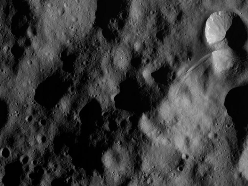
This image of the giant asteroid Vesta was obtained by Dawn in the evening Nov. 27 PST (early morning Nov. 28, UTC), as it was spiraling down from its high altitude mapping orbit to low altitude mapping orbit. Low altitude mapping orbit is the closest orbit Dawn will be making, at an average of 130 miles (210 kilometers) above the giant asteroid's surface. The framing camera obtained this image of an area in the northern mid-latitudes of Vesta from an altitude of about 140 miles (230 kilometers). Credit: NASA/JPL-Caltech/UCLA/MPS/DLR/IDA

Dawn arrived in orbit at Vesta in July 2011 after a nearly 4 year interplanetary cruise since blasting off atop a Delta II rocket from Cape Canaveral, Florida in September 2007. The probe then spent the first few weeks at an initial science survey altitude of about 1,700 miles (2,700 kilometers).

Gradually the spaceship spiraled down closer to Vesta using her ion propulsion thrusters.

See Vesta science orbit diagram, below, provided courtesy of Dr. Marc Rayman.

Along the way, the international science and engineering team commanded Dawn to make an intermediate stop this past Fall 2011 at the High Altitude Mapping orbit altitude (420 miles, or 680 kilometers).

“It is so cool now to have reached this low orbit [LAMO]. We already have a spectacular collection of images and other fascinating data on Vesta, and now we are going to gain even more,” Rayman told me.

“We have a great deal of work ahead to acquire our planned data here, and I’m looking forward to every bit!

Dawn will spend a minimum of 10 weeks acquiring data at the LAMO mapping orbit using all three onboard science instruments, provided by the US, Germany and Italy.

While the framing cameras (FC) from Germany and the Visible and Infrared Mapping spectrometer (VIR) from Italy will continue to gather mountains of data at their best resolution yet, the primary science focus of the LAMO orbit will be to collect data from the gamma ray and neutron detector (GRaND) and the gravity experiment.

GRaND will measure the elemental abundances on the surface of Vesta by studying the energy and neutron by-products that emanate from it as a result of the continuous bombardment of cosmic rays. The best data are obtained at the lowest altitude.

Dawn spacecraft - Science orbits at Vesta
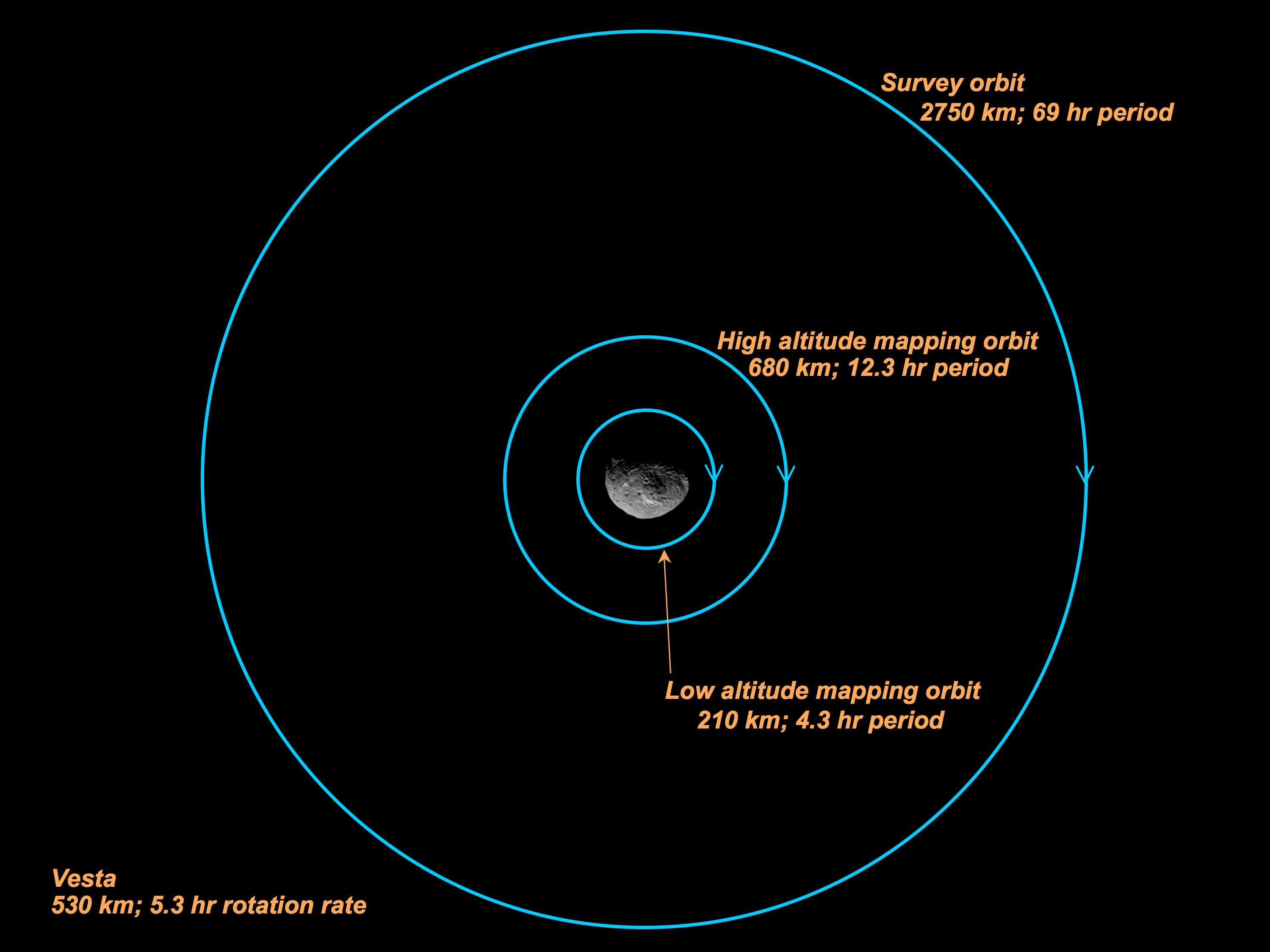
Credit: NASA/JPL-Caltech/Marc Rayman

By examining all the data in context, scientists hope to obtain a better understanding of the formation and evolution of the early solar system.

Vesta is a proto-planet, largely unchanged since its formation, and whose evolution into a larger planet was stopped cold by the massive gravitational influence of the planet Jupiter.

Dawn’s visit to Vesta has been eye-opening so far, showing us troughs and peaks that telescopes only hinted at,” said Christopher Russell, Dawn’s principal investigator, based at UCLA. “It whets the appetite for a day when human explorers can see the wonders of asteroids for themselves.”

After investigating Vesta for about a year, the engineers will ignite Dawn’s ion propulsion thrusters and blast away to Ceres, the largest asteroid which may harbor water ice and is another potential outpost for extraterrestrial life

Dawn will be the first spaceship to orbit two worlds and is also the first mission to study the asteroid belt in detail.

Asteroid Vesta from Dawn - Exquisite Clarity from a formerly Fuzzy Blob
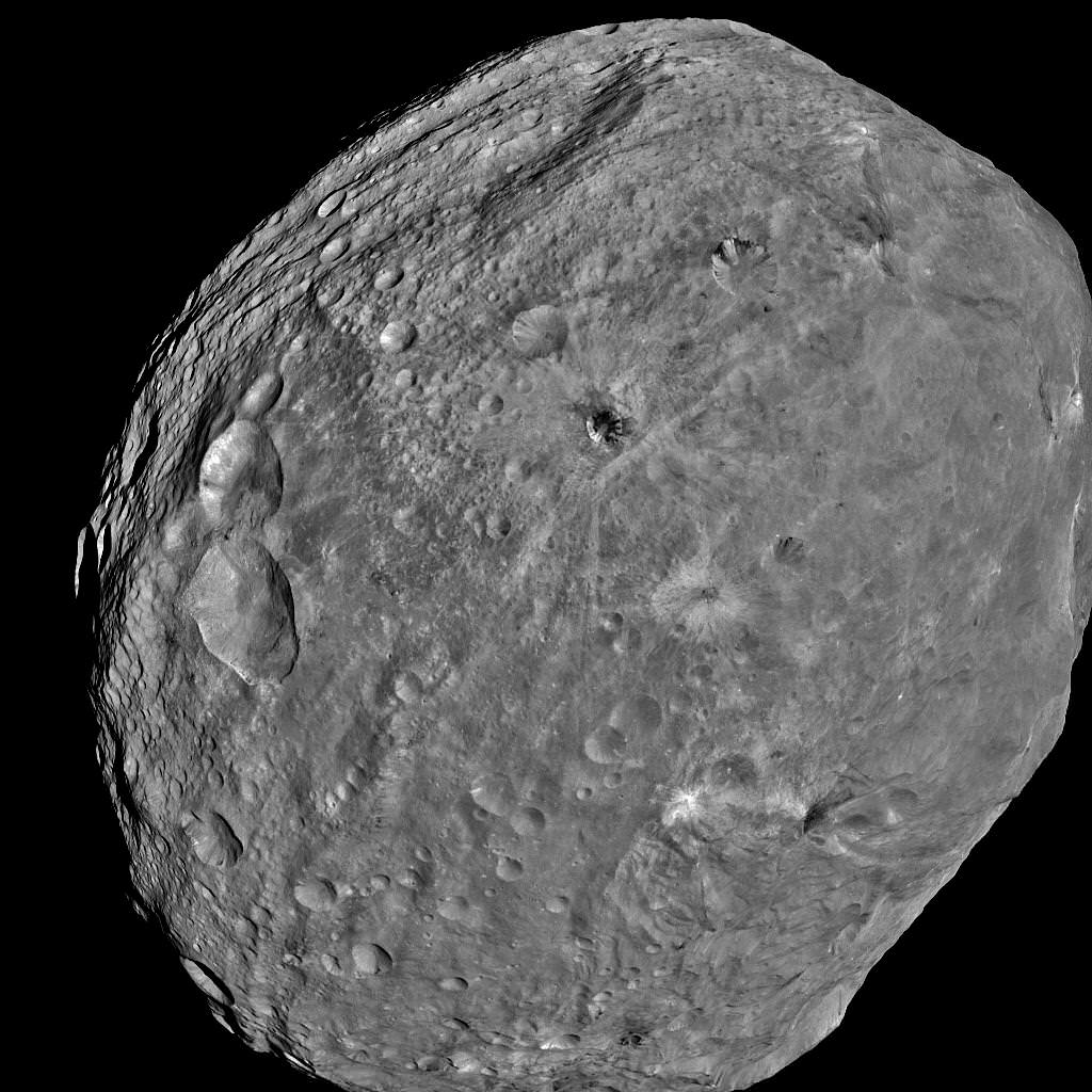
NASA's Dawn spacecraft obtained this image of the giant asteroid Vesta with its framing camera on July 24, 2011. It was taken from a distance of about 3,200 miles (5,200 kilometers). Before Dawn, Vesta was just a fuzzy blob in the most powerful telescopes. Dawn entered orbit around Vesta on July 15, and will spend a year orbiting the body before firing up the ion propulsion system to break orbit and speed to Ceres, the largest Asteroid. Credit: NASA/JPL-Caltech/UCLA/MPS/DLR/IDA
South Polar Region of Vesta - Enhanced View
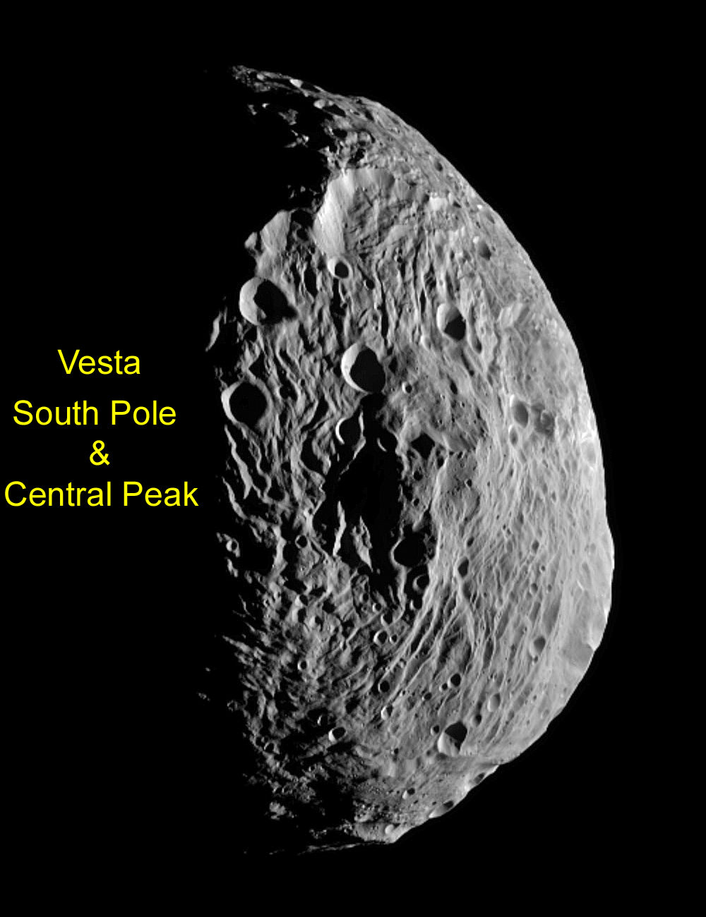
An ancient cosmic collision blasted away much of the south pole of Vesta, leaving behind an enoumous mountain about 3 times the height of Mt. Everest. NASA's Dawn spacecraft obtained this image centered on the south pole of Vesta with its framing camera on July 18, 2011 as it passed the terminator. The image has been enhanced to bring out more surface details. It was taken from a distance of about 6,500 miles (10,500 kilometers) away from the protoplanet Vesta. The smallest detail visible is about 1.2 miles (2.0 km). Credit: NASA/JPL-Caltech/UCLA/MPS/DLR/IDA. Enhanced and annotated by Ken Kremer

Read continuing features about Dawn by Ken Kremer starting here:

Rainbow of Colors Reveal Asteroid Vesta as More Like a Planet
Vrooming over Vivid Vestan Vistas in Vibrant 3 D – Video
NASA Planetary Science Trio Honored as ‘Best of What’s New’ in 2011- Curiosity/Dawn/MESSENGER
Dawn Discovers Surprise 2nd Giant South Pole Impact Basin at Strikingly Dichotomous Vesta
Amazing New View of the Mt. Everest of Vesta
Dramatic 3 D Imagery Showcases Vesta’s Pockmarked, Mountainous and Groovy Terrain
Rheasilvia – Super Mysterious South Pole Basin at Vesta
Space Spectacular — Rotation Movies of Vesta
3 D Alien Snowman Graces Vesta
NASA Unveils Thrilling First Full Frame Images of Vesta from Dawn
Dawn Spirals Down Closer to Vesta’s South Pole Impact Basin

A Day in the Sun: Will It Make a Difference for Russia’s Phobos-Grunt?

Phobos-Grunt
An artists concept of the Phobos-Grunt Mission. Credit: Roscosmos

[/caption]

Editor’s note: Dr. David Warmflash, principal science lead for the US team from the LIFE experiment on board the Phobos-Grunt spacecraft, provides an update on the mission for Universe Today.

It has been trapped in low Earth orbit for more than a month. So low is the orbit that it moves too fast to be contacted – unless controllers on the ground just happen to beam a signal at some unlikely angle. So short does its battery power last that it must be in sunlight while also in position to receive signals. Then, it must still have power to send telemetry back to the ground.

Even with these obstacles, Russia’s Phobos- Grunt probe did manage to communicate with the European Space Agency’s (ESA) antenna in Perth, Australia twice a couple of weeks ago, indicating that some of its systems were functioning. But subsequent attempts at communication have failed, despite the addition of ESA’s Canary Islands antenna at Maspalomas to the worldwide effort to reestablish control over the spacecraft.

Tracking of Grunt’s orbit has shown that its high point (apogee) and low point (perigee) continue to decrease, measuring about 289 kilometers and 203 kilometers in altitude, respectively, the last time I checked. Stories out of Russia in recent days describe how electrical cables found to be malfunctioning weeks before the launch were cut and connections re-soldered in a hurry to have the craft ready. Add to this the fact that the major sources on developments with the Grunt mission since its November 9 launch – Ria Novosti, the Russian Space Web, and ESA operations – all expect the craft to reenter Earth’s atmosphere in early January.

Taking all of this into account, it seems unlikely that Phobos-Grunt will ever respond to a signal again and say, “privyet’, much less turn on its engines and warp out of orbit. But there is an opportunity coming, a period when the odds that are stacked against the spacecraft may improve just a little.

Beginning Tuesday, December 13 at 17:00 universal time (UT) to Wednesday December 14, 23:00, Phobos-Grunt will be in sunlight throughout its entire orbit. It is not completely clear whether or not ESA will attempt to contact the probe during this period from Perth, or Maspalomas. Although attempts from Maspalomas were made throughout last week, the same attempts were scheduled to end on Friday, December 9. On the other hand, in a letter informing scientists participating in the mission that failure was the outcome, Phobos-Grunt science director, Lev Zelenyi, wrote: “Lavochkin Association specialists will continue their attempts to establish connection with the spacecraft and send commands until the very end of its existence.” Thus, despite the fact that the Russian Grunt team now is focused on the issue of reentry, we should not be surprised if they ask ESA to make one more attempt on Tuesday.

Will the greater than usual amount of sunlight allow the spacecraft’s communication system to work better than it usually does when it travels over tracking stations? Maybe yes, and maybe no. We should not get our hopes up that the craft will actually do anything but fall to Earth, and we’ve already discussed the possibility of the craft’s return capsule coming back in one piece.

But let us allow Phobos-Grunt its day in the Sun.

Michael Mann on Climate: “There’s Still Time to Make the Right Choices”

Climate scientist Michael Mann from Penn State recently spoke at a TED event, and what he says in this video is nearly the same as in the article I wrote a year ago after hearing Mann speak — but now you can hear it from Mann himself.

The real shame here is that he needs to keep telling these same stories despite the overwhelming scientific evidence for anthropogenic climate change.

A Blood-Red Moon

December 10 lunar eclipse by Joseph Brimacombe

[/caption]

Photographer Joseph Brimacombe created this stunning image of a ruddy Moon made during the total lunar eclipse of December 10, 2011. Images taken during the penumbral and total phases of the eclipse were combined to create a full-face image of the Moon in color. Beautiful!

The red tint of the Moon during an eclipse is caused by sunlight passing through Earth’s atmosphere, in effect projecting the colors of all the world’s sunsets onto the Moon’s near face. The vibrancy and particular hue seen depends on the clarity of the Earth’s atmosphere at the time of the eclipse.

Joseph’s location in Cairns, Australia allowed for great viewing of the eclipse in totality, whereas many areas of North and South America and Europe missed the full eclipse event.

See more images by Joseph on Flickr.

Image © Joseph Brimacombe. All rights reserved. Used with permission.

The Habitable Exoplanets Catalog is Now Online!

Credit: The Habitable Exoplanets Catalog, Planetary Habitability Laboratory @ UPR Arecibo (phl.upl.edu)

[/caption]

Anyone who has an interest in exoplanets probably knows about the various online catalogs that have become available in recent years, such as The Extrasolar Planets Encyclopaedia for example, providing up-to-date information and statistics on the rapidly growing number of worlds being discovered orbiting other stars. So far, these have been listings of all known exoplanets, both candidates and confirmed. But now there is a new catalog published by the Planetary Habitability Laboratory (a project of the University of Puerto Rico at Arecibo), which focuses exclusively on those planets which have been determined to be potentially habitable. The Habitable Exoplanets Catalog is a database which will serve as a key resource for scientists and educators as well as the general public.

As of right now, there are two confirmed planets and fourteen candidates listed, but those numbers are expected to grow over the coming months and years as more candidates are found and more of those candidates are confirmed. There is even a listing of habitable moons, whose existence have been inferred from the data, although none have been observed yet (finding exoplanets is challenging enough, but exomoons even more so!).

According to Abel Méndez, Director of the PHL and principal investigator, “One important outcome of these rankings is the ability to compare exoplanets from best to worst candidates for life.” He adds: “New observations with ground and orbital observatories will discover thousands of exoplanets in the coming years. We expect that the analyses contained in our catalog will help to identify, organize, and compare the life potential of these discoveries.”

The big question of course is whether any habitable planets are actually inhabited, two different things. To help answer that, it will be necessary to further analyze the atmospheres and surfaces of those planets, looking for any indication of possible biosignatures such as oxygen or methane. Kepler can’t do that directly, but subsequent telescopes such as the Terrestrial Planet Finder (TPF) will be able to, and provide a more accurate assessment of their physical composition, climate, etc.

Not long ago it wasn’t known if there even were any planets orbiting other stars; now we’re finding them by the thousands and soon we’ll be able to distinguish their unique physical characteristics and have a better idea of how many habitable worlds are out there – exciting times.

Geminid Meteor Shower Reminder and There’s An App For That!

2011 Geminids in the Winter Triangle. Image Courtesy of John Chumack

[/caption]

Have you been watching the Geminid Meteor Shower? With just hours to go before the peak, activity has been high – despite this year’s Moon! If you’d like to know more on the history of this meteor shower, then check out this great article by Adrian West. If you plan on watching and would like to do something cool and unusual, then step inside…

As you can see from this below video sent to us by John Chumack, even the bright moonlight isn’t interfering too badly with this year’s awesome Geminid meteor shower display. While it will make the fainter ones more difficult to observe, the “fireball” attitude of this meteor shower just won’t quit!

As a reminder, be sure to be out tonight and through tomorrow morning for the peak of the show. You’ll want to try when the skies are the darkest, begin before moonrise – but don’t forget the display is usually the greatest around 2:00 a.m. local time when the sky window is pointed in the optimum direction. Just look along the ecliptic plane and follow the constellation of Gemini as it cruises roughly east to west across the sky as the night goes on! If you get clouded out? Try again the next night… and the next. The stream for the Geminids is very broad and lasts for some time.

Now… if you really want to have some fun and have an iPhone, here’s a real treat…

Thanks to NASA, there’s a new application which will help you to track, count and record information about this meteor shower and any meteor shower in the world – including sporadic ones! The “Meteor Counter” app will allow you to record your observations with an easy-to-use “piano key” interface. As you strike the keys, the app records information for each meteor, including the brightness and time. Once your observing session ends, your information and data is automatically uploaded to NASA researchers for analysis.

Created by Dr. Bill Cooke, head of NASA’s Meteoroid Environment Office at NASA’s Marshall Space Flight Center and the one-and-only Dr. Tony Phillips of SpaceWeather.com, this new iPhone application is going to change the way you observe and help science, too. “We developed the iPhone app to be fun, and informative, but also to encourage going outside to observe the sky,” said Cooke. “Our hope is the app will be useful for amateur and professional astronomers — we want to include their observations in NASA’s discoveries — and have them share in the excitement of building a knowledge base about meteor showers.”

The app is more than just a set of keys, though… It has an optional recorded audio track and users can even add their own comments as they observe. This will all be sent to NASA along with the numbers – vital information which will help researchers identify meteors associated with specific radiants and one-time events. The “Meteor Counter” was designed with everyone in mind – from the beginner to the expert – and even those who have never seen a meteor before. “The beauty is that it gradually transforms novices into experts,“ says Cooke. “As an observer gains experience , we weigh their data accordingly in our analyses.”

The Meteor Counter app is also much more. It provides a newsfeed and event calendar that’s kept up-to-the-moment by professional NASA and meteor scientists, and it will help keep you informed of upcoming meteor showers and the most current sightings. The app is currently available for iPhone, iPad and iPod Touch. Download the free app at : http://itunes.apple.com/us/app/meteor-counter/id466896415. A version for other mobile devices will be available in the near future. Complete instructions for using the Meteor Counter app is available at: http://meteorcounter.com/ and more information about NASA’s Meteoroid Environment Office can be found at: http://www.nasa.gov/offices/meo/home/index.html.

Wishing you clear skies!

Original Story Source: NASA Marshall Space Flight Center News Release. Geminid photography courtesy of John Chumack.

Martian Sundial – A New “Curiosity”

The Sundial aboard NASA’s Curiosity rover. Credit: MER Sundial Team

[/caption]

There’s been a lot of artifacts sent to the surface of Mars – and now there’s about to be another one left for future generations to discover. Artist Jon Lomberg has collaborated with a team of space scientists to design a sundial which sports edges with designs and images. These embellishments have been authored by Jim Bell and the MER sundial team with the graphics designed by Lomberg.

The upcoming scientific mission to Mars – the Mars Science Laboratory – rover is called Curiosity. Much like its forerunners, NASA’s Mars Exploration Rovers Spirit and Opportunity, the planned sundial will also act as a camera calibration target for the Mastcam camera. Developed by Malin Space Science Systems, inc. of San Diego, CA, the Mastcam camera will be the rover’s principal instrument for photographing the Martian surface. It was developed under the supervision of Principal Investigator Michael Malin and the calibration target will become an outstanding educational opportunity for students. How? The image of the sundial can be transmitted back to Earth, where watchers can engage themselves with how such simple tools can be used to pinpoint times, dates, seasons and even latitudes on Mars. This celebration of space exploration is further cemented by the artistry contained on the “face” of the sundial – the word for Mars written in sixteen languages, including ancient Sumerian, Mayan, Inuktitut, and Hawaiian.

The original idea for this creative educational experience came from Bill Nye The Science Guy, who is currently the Executive Director of The Planetary Society. The message comes from Planetary Society President, Professor James Bell, who is also the MER imaging scientist and leader of the team which included Lomberg to design the sundial and its message. However, don’t think the message was designed for aliens! This time the artwork was intended for future generations of “Martians” – human beings who may one day explore or inhabit Mars. It might be within our lifetimes and it might be centuries from now, but perhaps some day an explorer will encounter what we’ve left behind. This is truly the target audience the message is being left for – but we can only hope they understand English, the primary language of the nation from where the probe originated. The illustrations are simple and elegant – an attempt to show mankind’s involvement with Mars. It combines classic illustrations of the god Ares, an astronomer’s interpretation of Mars, the Viking lander and assorted Mars spacecraft. Like the symbolic step on the Moon, the footprints on the Martian soil are meant to evoke the sands of time and our human need to explore.

The message on the edges of the Sundial. Credit: Jim Bell and Jon Lomberg

Both Spirit and Opportunity took similar sundials along for the ride – ones that included Bell and Lomberg on the design team. While the idea was much the same, they were crafted with a different date, motto and message that combined Lomberg’s drawings and children’s art. The same team, including Diane Bollen, Lou Friedman, Sheri Klug, Tyler Nordgren, Bill Nye, Steve Squyres, Larry Stark, Woody Sullivan, and Aileen Yingst, also provided input on Curiosity’s new message. Jim Bell is a planetary scientist from Arizona State University in Tempe AZ, the Payload Element Lead for the Pancam instruments on Spirit and Opportunity, and President of The Planetary Society in Pasadena, CA and artist Jon Lomberg was Design Director for NASA’s Voyager Golden Record and a long-time collaborator of Carl Sagan. He won an Emmy Award for his work as Chief Artist of the TV series COSMOS.

There are still a lot of credits to go along, though. Lomberg is on his fifth Mars’ message artifact and earlier work includes Russia’s failed Mars 96 mission. As of now, three of Lomberg’s visions have made it to the Red Planet and soon the fifth will be on its way!

Original Story Source: Citizen of the Galaxy.

A Refreshing Idea! Vote for Enabling City Kids to See Starry Skies

Now here’s a refreshing idea: create a “dark sky oasis” in suburban locations where city-dwellers can gather to see the stars and learn about the night sky. The International Dark-Sky Association has proposed a project to bring access to the starry night to urban areas through the creation of Suburban Outreach Sites. To make this project a reality, the IDA needs your help, and all it takes is a click of your mouse. Every year the Pepsi Refresh project gives away tens of thousands of dollars in grants to improve communities. The IDA is competing for one of these grants and needs your vote!

A Suburban Outreach Site could be built right in your community. These will be safe, public places where people can gather to enjoy the night sky. Scott Kardel, the Public Affairs Director for the IDA told Universe Today that Suburban Outreach Sites will be easily accessible from US cities.

“They will offer a good place to stargaze (relative to the area) and will hold free events to bring celestial wonders to the young and old,” Kardel said. “Suburban Outreach Sites will educate the next generation of astronomers to keep looking up, and inspire them to use better lighting to save energy, conserve natural resources, and help wildlife.”

These sites will be created through a partnership between IDA and local astronomy clubs.

If funded the Pepsi Refresh grant will help IDA designate Suburban Outreach Sites around the USA.

“IDA will coordinate action with our Chapters and astronomy clubs to select a safe place with a beautiful nighttime atmosphere,” Kardel said. “IDA will create ‘fresh’ programming ideas and event coordination, and even offer free materials on how to dim city lights and bring back the stars.”

Projects are chosen by popular vote and people can vote every day in the month of December to help IDA bring the night sky.

You can support the IDA by voting here: http://www.refresheverything.com/citystarparks

New Submillimetre Camera Sheds Light on the Dark Regions of the Universe

A composite image of the Whirlpool Galaxy (also known as M51). The green image is from the Hubble Space Telescope and shows the optical wavelength. The submillimetre light detected by SCUBA-2 is shown in red (850 microns) and blue (450 microns). The Whirlpool Galaxy lies at an estimated distance of 31 million light years from Earth in the constellation Canes Venatici Credit: JAC / UBC / Nasa

[/caption]

The stars and faint galaxies you see when you look up at the night sky are all emitting light within the visible light spectrum — the portion of the electromagnetic spectrum we can see with our unaided eyes or through optical telescopes. But our galaxy, and many others, contain huge amounts of cold dust that absorbs visible light. This accounts for the dark regions.

A new camera recently unveiled at the James Clerk Maxwell Telescope (JCMT) in Hawaii promises to figuratively shed light on this dark part of the universe. The SCUBA-2 submillimetre camera (SCUBA in this case is an acronym for Submillimetre Common-User Bolometer Array) can detect light at lower energy levels, allowing astronomers to gather data on these dark areas and ultimately learn more about our universe and its formation. 

Light is measurable; its intensity or brightness is measured by photons while colour is measured by the energy of the photons. Red photons have the least energy and violet photons have the most energy. This can also be thought of in terms of wavelengths. Light at longer wavelengths have less energy and light at shorter wavelengths have more energy. This continues beyond the visible light spectrum. As electromagnetic waves get shorter, we get ultraviolet light, x-rays, and gamma rays. As wavelengths get longer, we get infrared light, submillimetre light, and finally radio waves.

Panoramic view of the entire near-infrared sky reveals the distribution of galaxies beyond the Milky Way. Image credit: Thomas Jarrett, IPAC/Caltech.

On the longer end of the electromagnetic spectrum, infrared and radio telescopes have been around for decades helping astronomers understand more about the universe. But this is only part of the picture. The cold dust that absorbs the visible light to create the dark regions seen through optical telescopes is actually absorbing the light’s energy and reemitting it at longer wavelengths in the submillimetre region.

The first submillimetre camera, SCUBA, was designed and constructed at the Royal Observatory in Edinburgh in collaboration with the University of London. In 1997, it was up and running at the JCMT. Observations of submillimetre wavelengths are typically harder to gather — it takes a long time to image a small portion of the sky in this region. Nevertheless, submillimetre observations have already revealed a previously unknown population of distant, dusty galaxies as well as images of cold debris discs around nearby stars. This latter finding could be an indication of the presence of planetary systems.

A team of astronomers has recently developed the camera SCUBA-2 that can probe the submillimetre region with increased speed and much greater detail. But it’s a touchy instrument. Director of the JCMT Professor Gary Davis explains that for SCUBA-2 to detect extremely low energy radiation in the submillimetre region, “the instrument itself needs to be [extremely cold]. The detectors… have to be cooled to only 0.1 degree above absolute zero [–273.05°C], making the interior of SCUBA-2 colder than anything in the Universe that we know of!”

The infant Universe as imaged in the radio wavelength spectrum. Image Credit: NASA/WMAP Science Team.

The camera is a huge step in observational astronomy. Director of the United Kingdom Astronomy Teaching Centre Professor Ian Robson likened the technological leap between early sub-millimetre cameras and SCUBA-2 to the difference between wind-on film cameras and modern digital technology. “It is thanks to the ingenuity and abilities of our scientists and engineers that this immense leap in progress has been achieved,” he said.

Dr Antonio Chrysostomou, Associate Director of the JCMT, explains that SCUBA-2’s first task will be to carry out a series of surveys throughout the sky, mapping sites of star formation within our Galaxy, as well as planet formation around nearby stars. It will also survey our galactic neighbours and look into deep space to sample the youngest galaxies in the Universe. This latter task will be critical in helping astronomers understand how galaxies have evolved since the Big Bang.

The SCUBA-2 camera is housed on the 15 metre (about 50 foot) diameter JCMT situated close to the summit of Mauna Kea, Hawaii, at an altitude of 4092 metres (about 13,425 feet). It is typically used to study our Solar System, interstellar dust and gas, and distant galaxies.

Source: Revolutionary New Camera Reveals Dark Side of the Universe


The James Clerk Maxwell Telescope. Image credit: www.jach.hawaii.edu


Opportunity Discovers Most Powerful Evidence Yet for Martian Liquid Water

Opportunity discovers Water related mineral vein at Endeavour Crater - November 2011. Opportunity rover discovered Gypsum at the Homestake mineral vein, while exploring around the base of Cape York ridge at the rim of Endeavour Crater. The vein is composed of calcium sulfate and indicates the ancient flow of liquid water at this spot on Mars. Opportunity drove North (ahead) from here in search of a sunny winter haven. Credit: NASA/JPL/Cornell/Kenneth Kremer/Marco Di Lorenzo

[/caption]

NASA’s long lived Opportunity rover has discovered the most scientifically compelling evidence yet for the flow of liquid water on ancient Mars. The startling revelation comes in the form of a bright vein of the mineral gypsum located at the foothills of an enormous crater named Endeavour, where the intrepid robot is currently traversing. See our mosaic above, illustrating the exact spot.

Update: ‘Homestake’ Opportunity Mosaic above has just been published on Astronomy Picture of the Day (APOD) – 12 Dec 2011 (by Ken Kremer and Marco Di Lorenzo)

Researchers trumpeted the significant water finding this week (Dec. 7) at the annual winter meeting of the American Geophysical Union (AGU) in San Francisco.

“This gypsum vein is the single most powerful piece of evidence for liquid water at Mars that has been discovered by the Opportunity rover,” announced Steve Squyres of Cornell University, Ithaca, N.Y., Principal Investigator for Opportunity, at an AGU press conference.

The light-toned vein is apparently composed of the mineral gypsum and was deposited as a result of precipitation from percolating pools of liquid water which flowed on the surface and subsurface of ancient Mars, billions of years ago. Liquid water is an essential prerequisite for life as we know it.

“This tells a slam-dunk story that water flowed through underground fractures in the rock,” said Squyres. “This stuff is a fairly pure chemical deposit that formed in place right where we see it. That can’t be said for other gypsum seen on Mars or for other water-related minerals Opportunity has found. It’s not uncommon on Earth, but on Mars, it’s the kind of thing that makes geologists jump out of their chairs.”

'Homestake' Vein in Color and Close-up
This color view of a mineral vein called "Homestake" was taken by the panoramic camera (Pancam) on NASA's Mars Exploration Rover Opportunity. The vein is about the width of a thumb and about 18 inches (45 centimeters) long. Opportunity examined it in November 2011 and found it to be rich in calcium and sulfur, possibly the calcium-sulfate mineral gypsum.

The light-toned vein is informally named “Homestake”, and was examined up close by Opportunity’s cameras and science instruments for several weeks this past month in November 2011, as the rover was driving northwards along the western edge of a ridge dubbed ‘Cape York’ – which is a low lying segment of the eroded rim of Endeavour Crater.

Veins are a geologic indication of the past flow of liquid water

Opportunity just arrived at the rim of the 14 mile (22 kilometere) wide Endeavour Crater in mid-August 2011 following an epic three year trek across treacherous dune fields from her prior investigative target at the ½ mile wide Victoria Crater.

“It’s like a whole new mission since we arrived at Cape York,” said Squyres.

‘Homestake’ is a very bright linear feature.

“The ‘Homestake’ vein is about 1 centimeter wide and 40 to 50 centimeters long,” Squyres elaborated. “It’s about the width of a human thumb.”

Opportunity's Approach to 'Homestake'
This view from the front hazard-avoidance camera on NASA's Mars Exploration Rover Opportunity shows the rover's arm's shadow falling near a bright mineral vein informally named Homestake. The vein is about the width of a thumb and about 18 inches (45 centimeters) long. Opportunity examined it in November 2011 and found it to be rich in calcium and sulfur, possibly the calcium-sulfate mineral gypsum. Opportunity took this image on Sol 2763 on Mars (Nov. 7, 2011). Credit: NASA/JPL-Caltech

Homestake protrudes slightly above the surrounding ground and bedrock and appears to be part of a system of mineral veins running inside an apron (or Bench) that in turn encircles the entire ridge dubbed Cape York.

In another first, no other veins like these have been seen by Opportunity throughout her entire 20 miles (33 kilometers) and nearly eight year long Martian journey across the cratered, pockmarked plains of Meridiani Planum, said Squyres.

The veins have also not been seen in the higher ground around the rim at Endeavour crater.

“We want to understand why these veins are in the apron but not out on the plains,” said the mission’s deputy principal investigator, Ray Arvidson, of Washington University in St. Louis. “The answer may be that rising groundwater coming from the ancient crust moved through material adjacent to Cape York and deposited gypsum, because this material would be relatively insoluble compared with either magnesium or iron sulfates.”

Opportunity was tasked to engage her Microscopic Imager and Alpha Particle X-ray Spectrometer (APXS) mounted on the terminus of the rover’s arm as well as multiple filters of the mast mounted Panoramic Camera to examine ‘Homestake’.

“The APXS spectrometer shows ’Homestake’ is chock full of Calcium and Sulfur,” Squyres gushed.

Microscopic Close-up View of 'Homestake' Vein
This close-up view of a mineral vein called Homestake comes from the microscopic imager on Opportunity. The vein is about the width of a thumb and about 18 inches (45 centimeters) long. Opportunity examined it in November 2011 and found it to be rich in calcium and sulfur, possibly the calcium-sulfate mineral gypsum. Homestake is near the edge of the "Cape York" segment of the western rim of Endeavour Crater. This view blends three exposures taken by the microscopic imager during the 2,765th and 2,766th Martian days, or sols, of Opportunity's career on Mars (Nov. 3 and 4, 2011). Credit: NASA/JPL-Caltech/Cornell/USGS

The measurements of composition with the APXS show that the ratio points to it being relatively pure calcium sulfate, Squyres explained. “One type of calcium sulfate is gypsum.”

Calcium sulfate can have varying amounts of water bound into the minerals crystal structure.

The rover science team believes that this form of gypsum discovered by Opportunity is the dihydrate; CaSO4•2H2O. On Earth, gypsum is used for making drywall and plaster of Paris.

The gypsum was formed in the exact spot where Opportunity found it – unlike the sulfate minerals previously discovered which were moved around by the wind and other environmental and geologic forces.

“There was a fracture in the rock, water flowed through it, gypsum was precipitated from the water. End of story,” Squyres noted. “There’s no ambiguity about this, and this is what makes it so cool.”

At Homestake we are seeing the evidence of the ground waters that flowed through the ancient Noachian rocks and the precipitation of the gypsum, which is the least soluble of the sulfates, and the other magnesium and iron sulfates which Opportunity has been driving on for the last 8 years.

Opportunity Traverse Map 2004 to 2011
Traverse map showing the 8 Year Journey of Opportunity from Eagle Crater landing site Sol 1 (Jan. 24, 2004) to Sol 2775 (November 2011). Map shows rover location around Homestake water related mineral on Sol 2763 (November 2011) at Cape York ridge at Endeavour Crater rim. Endeavour Crater is 14 miles or 22 kilometers in diameter. Opportunity has driven more than 21 miles (34 km).
Credit: NASA/JPL/Cornell/Marco Di Lorenzo/Kenneth Kremer

“Here, both the chemistry, mineralogy, and the morphology just scream water,” Squyres exclaimed. “This is more solid than anything else that we’ve seen in the whole mission.”

It’s inconceivable that the vein is something else beside gypsum, said Squyres.

As Opportunity drove from the plains of Meridiani onto the rim of Endeavour Crater and Cape York, it crossed a geologic boundary and arrived at a much different and older region of ancient Mars.

The evidence for flowing liquid water at Endeavour crater is even more powerful than the silica deposits found by Spirit around the Home Plate volcanic feature at Gusev Crater a few years ago.

“We will look for more of these veins in the [Martian] springtime,” said Squyres.

If a bigger, fatter vein can be found, then Opportunity will be directed to grind into it with her still well functioning Rock Abrasion Tool, or RAT.

Homestake was crunched with the wheels – driving back and forth over the vein – to break it up and expose the interior. Opportunity did a triple crunch over Homestake, said Arvidson.

Homestake was found near the northern tip of Cape York, while Opportunity was scouting out a “Winter Haven” location to spend the approaching Martian winter.

Arvidson emphasized that the team wants Opportunity to be positioned on a northerly tilted slope to catch the maximum amount of the sun’s rays to keep the rover powered up for continuing science activities throughout the fast approaching Martian winter.

“Martian winter in the southern hemisphere starts on March 29, 2012. But, Solar power levels already begin dropping dramatically months before Martian winter starts,” said Alfonso Herrera to Universe Today, Herrera is a Mars rover mission manager at NASA’s Jet Propulsion Laboratory in Pasadena, Calif.

“Opportunity is in excellent health,” said Bruce Banerdt, the Project Scientist for the Mars rover mission at JPL.

“This has been a very exciting time. We’ll head back south in the springtime and have a whole bunch of things to do with a very capable robot,” Squyres concluded.

'Botany Bay' and 'Cape York' with Vertical Exaggeration
This graphic combines a perspective view of the "Botany Bay" and "Cape York" areas of the rim of Endeavour Crater on Mars, and an inset with mapping-spectrometer data. Major features are labeled. In the perspective view, the landscape's vertical dimension is exaggerated five-fold compared with horizontal dimensions. NASA's Mars Exploration Rover Opportunity examined targets in the Cape York area during the second half of 2011. The perspective view was generated by producing an elevation map from a stereo pair of images from the High Resolution Imaging Science Experiment (HiRISE) camera on NASA's Mars Reconnaissance Orbiter, then draping one of the HiRISE images over the elevation model. The inset presents data from the Compact Reconnaissance Imaging Spectrometer for Mars (CRISM) instrument on the Mars Reconnaissance Orbiter. In this CRISM observation, taken on March 29, 2011 Thermal inertia estimates from observations by the Thermal Emission Imaging System on NASA's Mars Odyssey orbiter indicate that Botany Bay is a region with extensive outcrop exposures. Credit: NASA/JPL-Caltech/UA/JHUAPL

Meanwhile, NASA’s next leap in exploring potential Martian habitats for life – the car sized Curiosity Mars Science Lab rover – is speeding towards the Red Planet.

Read Ken’s continuing features about Opportunity starting here:

NASA Robot seeks Goldmine of Science and Sun at Martian Hill along vast Crater
Opportunity spotted Exploring vast Endeavour Crater from Mars Orbit
Twin Towers 9/11 Tribute by Opportunity Mars Rover
NASA Robot arrives at ‘New’ Landing Site holding Clues to Ancient Water Flow on Mars
Opportunity Arrives at Huge Martian Crater with Superb Science and Scenic Outlook
Opportunity Snaps Gorgeous Vistas nearing the Foothills of Giant Endeavour Crater