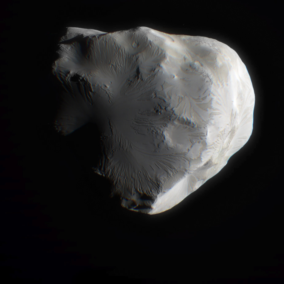
Color composite of Helene from June 18, 2011 flyby. NASA / JPL / SSI / J. Major
[/caption]
On June 18, 2011, the Cassini spacecraft performed a flyby of Saturn’s moon Helene. Passing at a distance of 6,968 km (4,330 miles) it was Cassini’s second-closest flyby of the icy little moon.
The image above is a color composite made from raw images taken with Cassini’s red, green and blue visible light filters. There’s a bit of a blur because the moon shifted position in the frames slightly between images, but I think it captures some of the subtle color variations of lighting and surface composition very nicely!
3D anaglyph of Helene assembled by Patrick Rutherford.
At right is a 3D anaglyph view of Helene made by Patrick Rutherford from Cassini’s original raw images … if you have a pair of red/blue glasses, check it out!
Cassini passed from Helene’s night side to its sunlit side. This flyby will enable scientists to create a map of Helene so they can better understand the moon’s history and gully-like features seen on previous flybys.
(When Cassini acquired the images, it was oriented such that Helene’s north pole was facing downwards. I rotated the image above to reflect north as up.)
Helene orbits Saturn at the considerable distance of 234,505 miles (377,400 km). Irregularly-shaped, it measures 22 x 19 x 18.6 miles (36 x 32 x 30 km).
Helene is a “Trojan” moon of the much larger Dione – so called because it orbits Saturn within the path of Dione, 60º ahead of it. (Its little sister Trojan, 3-mile-wide Polydeuces, trails Dione at the rear 60º mark.) The Homeric term comes from the behavioral resemblance to the Trojan asteroids which orbit the Sun within Jupiter’s path…again, 60º in front and behind. These orbital positions are known as Lagrangian points (L4 and L5, respectively.)
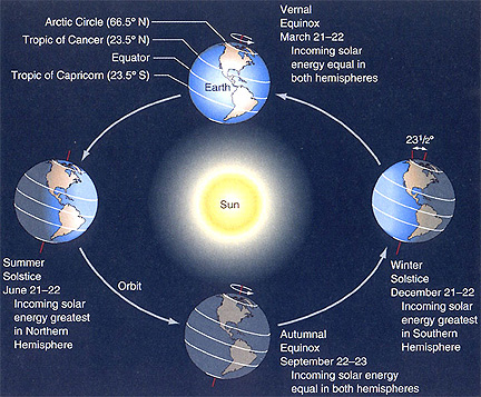
June 21st, 2011 is Summer Solstice – the longest day of the year.
This is the time when the Sun is at its highest or most northerly point in the sky in the Northern Hemisphere and when we receive the most hours of daylight. If you live in the Southern Hemisphere it is the reverse, so you will be having “Winter Solstice.”
Also known as “Midsummer” the Summer Solstice gets its name from the Latin for sol (sun) and sistere (to stand still). The Sun reaches its most Northerly point and momentarily stands still before starting its journey South in the sky again until it reaches its most Southerly point “Winter Solstice”, before repeating the cycle. This is basically how we get our seasons.
It’s not actually the Sun that moves North or South over the seasons although it may appear so. It’s the Earths axial tilt that causes the Sun to change position in the sky as the Earth orbits the Sun throughout the year.
The angle of the Sun and the Earth's seasons. Image credit: NASA
Summer Solstice/ Midsummer is steeped in ancient folklore especially in Northern Europe with the most famous place directly related to it being Stonehenge, where the sun has been worshiped for thousands of years.
Stonehenge Credit: bistrochic.net
The Sun reaches its most Northerly point in the sky at 17:16 UTC momentarily and from that point forward starts to make its way South. This means the days will get shorter and shorter until Winter Solstice in December.
What you’re looking at isn’t a vintage telescope, but a modern day long focus refractor. Custom-built to exacting standards, this new twist on an old breed doesn’t make you one of the crowd… it makes you stand out in one.
Drive your car down the highway and how long does it take to spot a model that’s the same as yours? Get that new look in clothes and sure enough you’ll catch someone wearing the same shirt. When it comes to telescopes, walk through any star party and you’re sure to find a piece of equipment identical to what you own. Why not turn having a telescope into an ultra personal experience by choosing a one that’s totally unique? A Skylight Telescopes Custom Refractor can do that for you.
Hand-crafted and inspired directly by telescopes designed in the 19th Century, Skylight Custom Refractors show attention to detail and craftsmanship that are simply unsurpassed. They are the brainchild of Richard Day. “Being surrounded by interesting refractors made me a little jaded towards modern telescopes and the fairly obvious similarities found from brand to brand. I was particularly captivated by the beautiful refractors made by T. Cooke and Sons… not very well known in the USA, but revered in the UK and Europe.” says Day. “While stepping back and appreciating a particularly nice 3″/f15 example, I had a ‘why doesn’t anyone make anything like this anymore?’ moment, and so I decided that I would.”
From conception to finished product took Richard two years, but the end result quickly captivated the UK publication, Astronomy Now. “This telescope delivers a serious optical punch. Star testing under calm conditions at 187x showed nearly identical diffraction rings inside and outside focus. In focus, stars displayed a hard Airy disc with a pair of textbook perfect diffraction rings round them. I’m happy to report a cautious 1/8 wave for this optic. I could not detect coma, field curvature, astigmatism or distortion.” says Neil English. “The last quarter moon was mind-boggling. I had to charge the telescope with stupendously high powers (about 100x per inch) before any image breakdown manifested itself. At these excessive powers, image quality was still very good, with only mere traces of yellow and blue tinges visible around crater rims at areas of high contrast.”
With all of this comes a price – and Skylight Refractors don’t come cheap. But, there is a reason. Each one of these unique telescopes is custom built and quality optics are expensive. Only through mass production can a telescope company lower their prices and Richard isn’t a company… he’s an artisan. “Victorian design is now virtually lost in favour of mass produced, CNC machined white tubes, which I simply do not find terribly interesting.” says Day. “The Victorian design element is an exercise in elegance for me…many people have told me that my scopes are the most beautiful that they’ve ever seen, and this pleases me greatly.”
Originally a Vancouver native, Richard takes his telescope making seriously. Every telescope he designs is individually star tested from his London home, then signed and numbered before they are released. With the exception of the focuser and optics, it’s all handcrafted and when each limited number of a model is gone? It’s gone forever. Because of their exclusive nature, Skylight Refractors were never meant to be offered “wholesale” – but now a few of them are available around the world. Where can they be found? In Europe, it’s Skylight Telescopes. In Canada, it’s Vancouver Telescope Centre or Khan Scope Centre. In the United States, it’s from my home-zone, OPT.
When Skylight Refractors appeared at the 2011 NEAF gathering in Rockland, New York, it was all one could do to not want to take one home… permanently. Quite simply put, they are that beautiful and well-constructed. Lunar and planetary observing, double stars… You’re no longer just observing by rote, but practicing a time-honored craft. Just imagine yourself owning a telescope that matches the caliber of those used by the Cambridge Observatory, Coats Observatory, Carter Observatory or Yorkshire Philosophical Society. So enduring was this design that many are still in use today. Be assured that owning a classic telescope is like owning your own personal piece of history – one that will be around long after fancy has faded. I cannot thank Richard enough for allowing me to take a personal look at – and interest in – what he has to offer.
Why sail along the stars when you can sail with them?
Addendum: This review was intended to re-kindle the romantic and personal experience which observers feel for their equipment. Make no mistake – this is a high quality refractor which employs state-of-the-art components such as high quality Japanese glass objectives in a handmade collimateable countercell and a premium Baader Steeltrack focuser. Its design allows for high magnfication – above and beyond the call of duty, and the color correction is outstanding. This is not a “model” telescope, but a telescope modeled after a time-honored design. Its performance level – like all telescopes – relies on the eyepiece introduced. Use lesser quality and you’ll get diminuished performance. Use a premium occular and you’ll get the view you paid for! And its cost, by the way, is not only comparable to similar custom made refractors (such as Stellarvue), but even less in some instances.
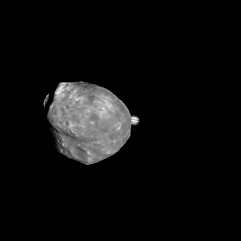
Conjunction of Jupiter and Phobos from Mars Express (rotated so north is up.)
Here’s a cool animation showing Mars’ little moon Phobos passing in front of distant Jupiter from the viewpoint of ESA’s Mars Express orbiter:
The conjunction event occurred on June 1.
[/caption]
Only 21 km (13 miles) across at the widest, the irregularly-shaped Phobos may have been created by a large impact on Mars in its distant past, a chunk of the planet’s crust thrown into orbit. Mars Express most recently performed a close flyby of Phobos back on January 9, passing it at a distance of only 100 km (62 miles).
What’s really amazing to think about is the distances between these two worlds – about 529 million km! But those kinds of distances are no hindrance to vision out in space, especially when the farther object is a giant planet like Jupiter.
The images were taken with Mars Express’ High Resolution Stereo Camera (HRSC), which was kept centered on Jupiter during the conjunction. A total of 104 images were taken over a span of 68 seconds to create the animation.
“By knowing the exact moment when Jupiter passed behind Phobos, the observation will help to verify and even improve our knowledge of the orbital position of the martian moon.”
– ESA
Read the news release on the ESA Space Science site here.
All images shown here were processed at the Department of Planetary Sciences and Remote Sensing at the Institute of Geological Sciences of the Freie Universität Berlin. Credit: ESA/DLR/FU Berlin (G. Neukum)
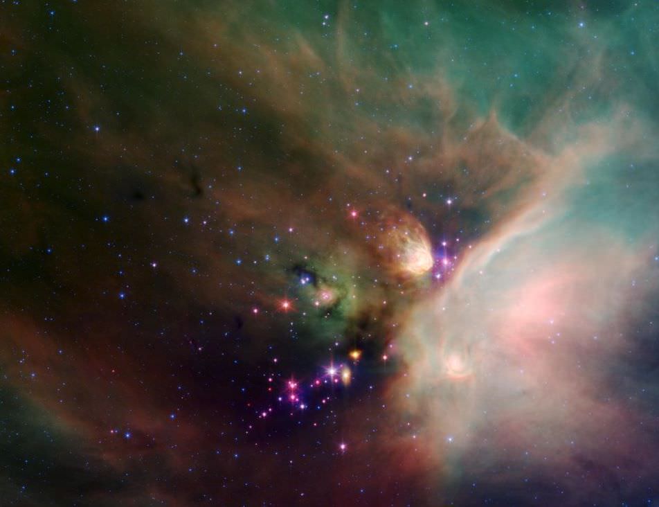
The Rho Ophiuchi cloud complex - within which cloud L1688 is the most active star-forming location. Credit NASA.
[/caption]
Molecular clouds are called so because they have sufficient density to support the formation of molecules, most commonly H2 molecules. Their density also makes them ideal sites for new star formation – and if star formation is prevalent in a molecular cloud, we tend to give it the less formal title of stellar nursery.
Traditionally, star formation has been difficult to study as it takes place within thick clouds of dust. However, observation of far-infrared and sub-millimetre radiation coming out of molecular clouds allows data to be collected about prestellar objects, even if they can’t be directly visualized. Such data are drawn from spectroscopic analysis – where spectral lines of carbon monoxide are particularly useful in determining the temperature, density and dynamics of prestellar objects.
Far-infrared and sub-millimetre radiation can be absorbed by water vapor in Earth’s atmosphere, making astronomy at these wavelengths difficult to achieve from sea level – but relatively easy from low humidity, high altitude locations such as Mauna Kea Observatory in Hawaii.
Simpson et al undertook a sub-millimeter study of the molecular cloud L1688 in Ophiuchus, particularly looking for protostellar cores with blue asymmetric double (BAD) peaks – which signal that a core is undergoing the first stages of gravitational collapse to form a protostar. A BAD peak is identified through Doppler-based estimates of gas velocity gradients across an object. All this clever stuff is done via the James Clerk Maxwell Telescope in Mauna Kea, using ACSIS and HARP – the Auto-Correlation Spectral Imaging System and the Heterodyne Array Receiver Programme.
A sample of protostellar cores from cloud L1688 in Ophiuchus. Cores with signature blue asymmetric double (BAD) peaks, indicating gas infall due to gravitational collapse, are all on the right side of the Jeans Instability line. This plot enables the likely evolutionary path of protostellar cores to be estimated. Credit: Simpson et al.
The physics of star formation are not completely understood. But, presumably due to a combination of electrostatic forces and turbulence within a molecular cloud, molecules begin to aggregate into clumps which perhaps merge with adjacent clumps until there is a collection of material substantial enough to generate self-gravity.
From this point, a hydrostatic equilibrium is established between gravity and the gas pressure of the prestellar object – although as more matter is accreted, self-gravity increases. Objects can be sustained within the Bonnor-Ebert mass range – where more massive objects in this range are smaller and denser (High Pressure in the diagram). But as mass continues to climb, the Jeans Instability Limit is reached where gas pressure can no longer withstand gravitational collapse and matter ‘infalls’ to create a dense, hot protostellar core.
When the core’s temperature reaches 2000 Kelvin, H2 and other molecules dissociate to form a hot plasma. The core is not yet hot enough to drive fusion but it does radiate its heat – establishing a new hydrostatic equilibrium between outward thermal radiation and inward gravitational pull. At this point the object is now officially a protostar.
Being now a substantial center of mass, the protostar is likely to draw a circumstellar accretion disk around it. As it accretes more material and the core’s density increases further, deuterium fusion commences first – followed by hydrogen fusion, at which point a main sequence star is born.
Space Shuttle Atlantis and cargo canister at Launch Pad 39A for Final Shuttle Flight. This view shows the delivery of the cargo canister – white rectangular box - with the payloads for the last shuttle mission; STS-135. The canister has been hoisted up the Rotating Service Structure, at right, for installation into the orbiters payload bay. Credit: Ken Kremer
[/caption]
KENNEDY SPACE CENTER – The cargo canister for NASA’s final space shuttle mission was delivered to the sea-side launch pad at the Kennedy Space Center (KSC) in Florida and hoisted up the pads massive launch pad gantry early Friday (June 17).
NASA is targeting a July 8 blastoff of the STS-135 mission with Space Shuttle Atlantis and the last cargo a shuttle will ever haul to space. The 60 foot long cargo canister is the size of a shuttle payload bay.
The STS-135 mission is the very final flight of the three decade long Space Shuttle Era and is slated for liftoff at 11:26 a.m. EDT from Launch Pad 39A. The flight is scheduled to last 12 days and will be NASA’s 36th and last shuttle mission bound for the International Space Station (ISS).
Atlantis will deliver the Italian- built “Raffaello” logistics module to the orbiting outpost.
Raffaello is loaded full with about 5 tons of critical space parts, crew supplies and experiments to sustain space station operations once the shuttles are retired at the conclusion of the STS-135 mission, according to Joe Delai, NASA’s Payload Processing Manager for the STS-135 mission.
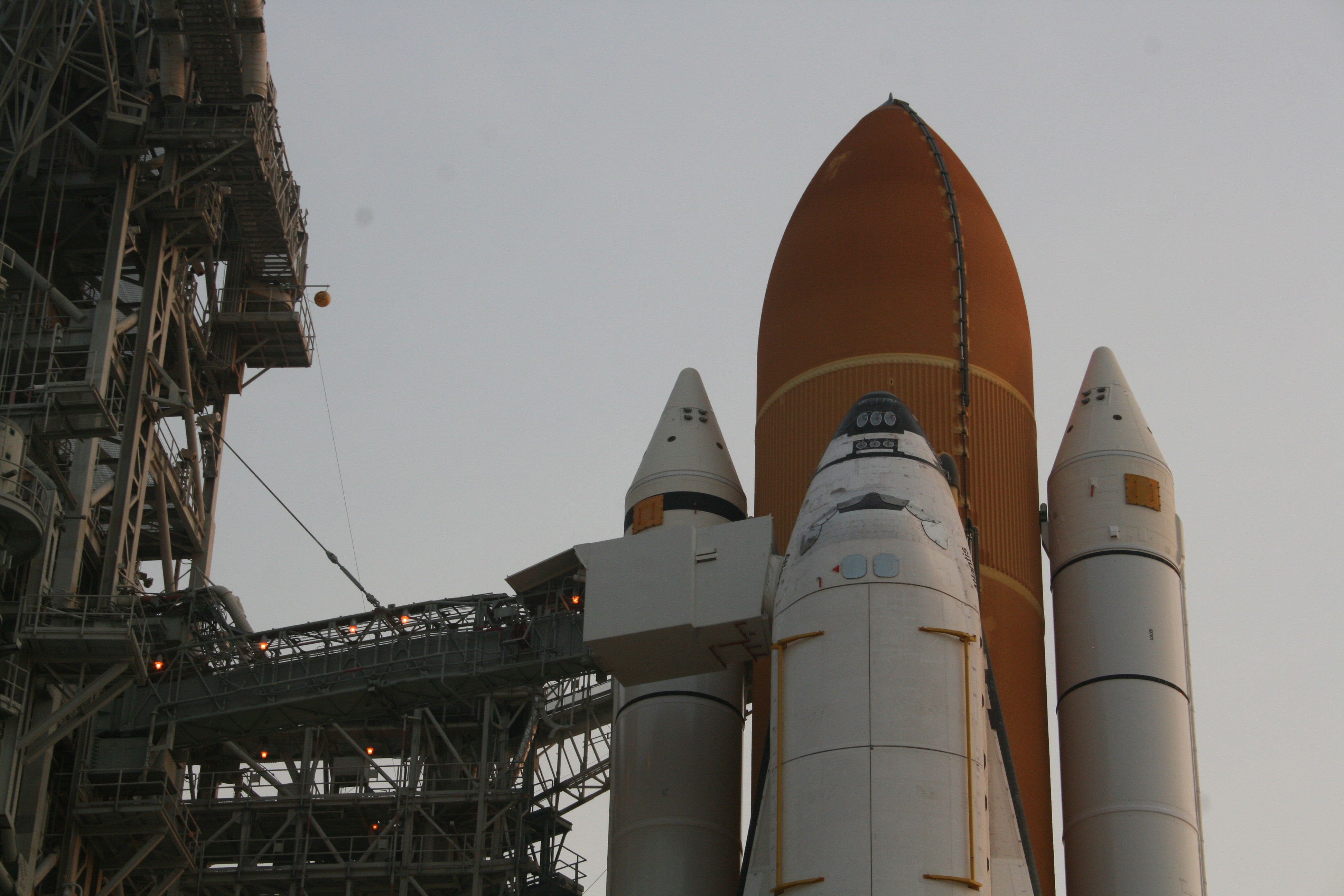
Close up of top of shuttle Atlantis stack at Launch Pad 39 A
Astronauts will walk through the White Room at left to enter Atlantis crew cabin. Credit: Ken Kremer
NASA technicians at the launch pad have closed the cocoon-like Rotating Service Structure (RSS) back around the orbiter to gain access to the vehicles payload bay. Atlantis’ payload bay doors will be opened Saturday night and the cargo will be installed into the shuttle’s cargo bay on Monday (June 20).
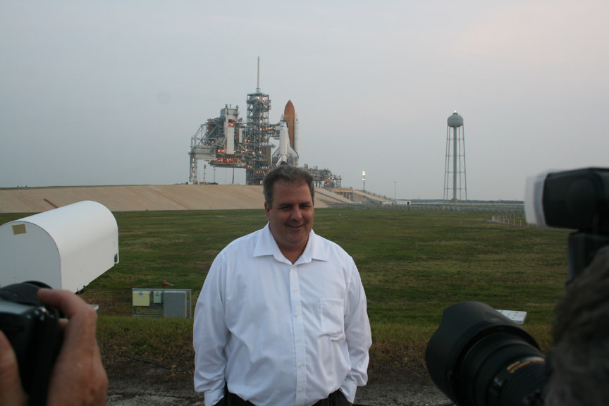
The secondary payload is dubbed the Robotic Refueling Mission (RRM) – a sort of “gas station in space” said Delai, who spoke to me at Pad 39A.
Joe Delai, NASA STS-135 Payload Processing manager, answers media queries at Launch Pad 39A. Credit: Ken Kremer
Pad workers were also busy on Saturday (June 18) with work to begin the collection of high resolution X-ray scans of Atlantis External Tank at certain support ribs on the shuttle facing side, according to Allard Beutel, a NASA KSC shuttle spokesman.
“The technicians will scan the tops and bottoms of 50 support beams, called stringers, to confirm that there are no issues following the tanking test conducted by NASA this week at the launch pad”, Beutel said.
The reinforcing stringers were installed after minute cracks were discovered during the propellant loading of 535,000 gallons of super cold liquid oxygen and hydrogen into the fuel tank during the initial launch attempt of the STS-133 mission in November 2010. “No problems are expected and this work is just being done as a precautionary measure.”
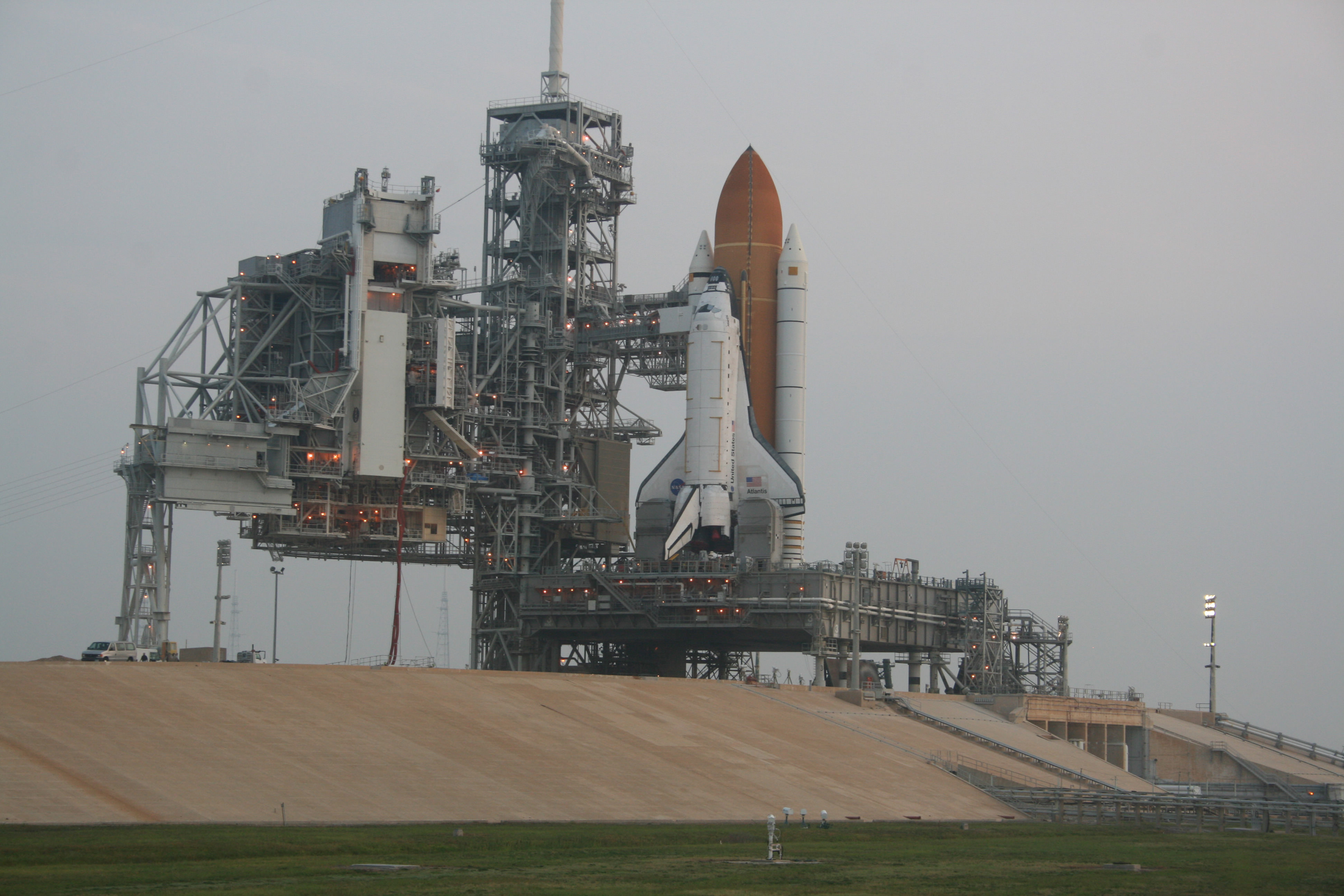
Space Shuttle Atlantis sits atop Launch Complex 39 A at Sunrise at the Kennedy Space Center
The last ever shuttle flight will blast off on July 8. Credit: Ken Kremer
During the tanking test, a potential fuel leak was discovered in a hydrogen fuel valve in Space Shuttle Main Engine No. 3, the right most engine.
“Technicians will spend the next week swapping out the engine valve with a new one and conduct tests to verify the fix solved the problem,” Buetel told me. “NASA expects the work can be completed with no delay to the July 8 launch.”
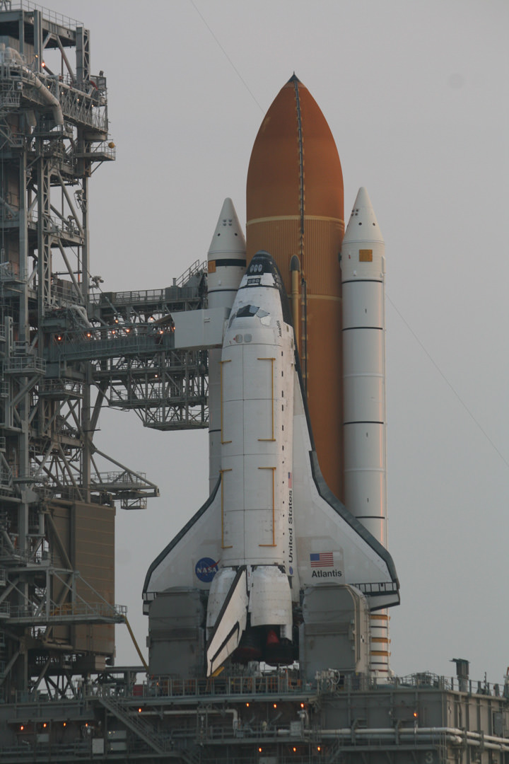
Space Shuttle Atlantis is set to blastoff on July 8 on NASA’s Final Shuttle Mission; STS-135. Credit: Ken Kremer
The engine leak would have been a show stopper and scrubbed the launch if this had been the real countdown on July 8, said Beutel – to the huge disappointment of the 500,000 to 750,000 folks expected to pack the Florida Space Coast.
The hydrogen valve replacement and X-Ray scans are being completed in parallel out at the pad.
The STS-135 crew of four veteran shuttle astronauts is led by Shuttle Commander Christopher Ferguson. Also aboard are Pilot Doug Hurley and Mission Specialists Sandy Magnus and Rex Walheim.
The crew will fly to into the Kennedy Space Center from Houston aboard their T-38 jets on Monday for several days of pre-launch training.
I will be covering the STS-135 launch for Universe Today on site at the KSC Press site, location of the world famous countdown clock. Ken Kremer and Space Shuttle Atlantis on top of Launch Pad 39A. Credit: Ken Kremer
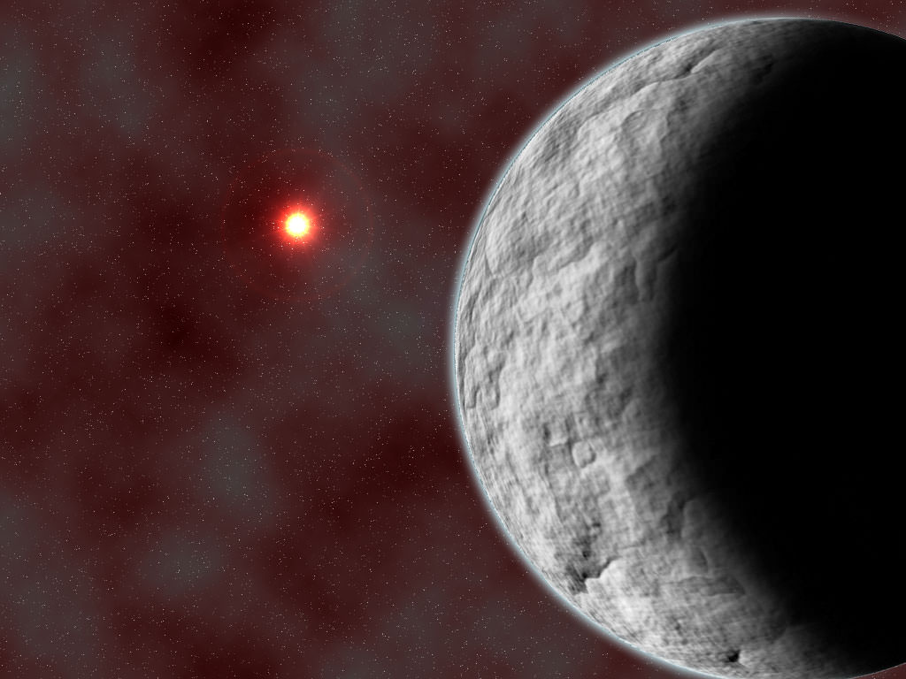
Artist's impression of the view from a hypothetical moon around a exoplanet orbiting a triple star system. Credit: NASA
[/caption]
With the arrival of the Cassini–Huygens mission in 2004 to Saturn’s satellite Titan, we terrestrials became acutely aware that similar moons could be orbiting similarly large planets in other solar systems besides our own. These extrasolar moons, or exomoons, might be a little bit difficult to distinguish with our current equipment, but our technological grasp has greatly improved in recent years. Now current studies suggest that not only can these naturally occurring satellites exist – but they also might be habitable.
As we know, there isn’t exactly a lack of planetary candidates hospitable to life. At least 40 so far discovered are within Earth-like tolerances and it’s only a matter of time before transit timings (TTV and TDV) and wobble variations will allow us to detect their moons. If the potential is there for the giant planet – then why not its companion?
“The satellites of extrasolar planets (exomoons) have been recently proposed as astrobiological targets. Since giant planets in the habitable zone are thought to have migrated there,” says Simon Porter of Lowell Observatory and William Grundy of Arizona State University. “It is possible that they may have captured a former terrestrial planet or planetesimal.”
Although we’re aware of life-possible exoplanet existence, we’re not yet sure of how they got to their current position. Simulations show they may have formed on the edge of where ice can exist, but this might also make them a bit inhospitable. Disk migration would bring them closer to the parent star – but also make them intolerably hot. Yet, there’s a theory which says during the shuffle that some planetesimals could have been “swapped” in the process.
“We therefore attempt to model the dynamical evolution of a terrestrial planet captured into orbit around a giant planet in the habitable zone of a star.” says Porter and Grundy. “We find that approximately half of loose elliptical orbits result in stable circular orbits over timescales of less than a few million years. We also find that those orbits are mostly low-inclination, but have no prograde/retrograde preference.”
Right now the most probable candidates for “living” exomoons would be around planets very similar to Neptune and orbiting a star similar to our Sun. Once these Earth-massed satellites have stabilized into a long-lived orbit, they should be within the range of findability using the transit timing variation much stronger than the duration variation – even if their orbit is tight to the parent planet.
“In addition, we calculate the transit timing and duration variations for the resulting systems, and find that potentially habitable Earth-mass exomoons should be detectable.” reports the team. “Even with these closer orbits, some exomoons are still within the range of detectability. The combination of TTV and TDV may offer a stronger detection signal than photometry for these orbits, though both could detect some of the orbits produced.”
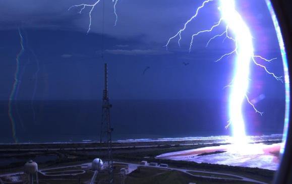
Lightning strikes near Kennedy Space Center Pad B. Credit: NASA
[/caption]
That was close! A fixed camera at launchpad B at Kennedy Space Center (which is being torn down/modified) captured an amazing lightning strike earlier this week.
In planet hunting today, there seems to be one burning question that nearly every new article published touches on: Where did these planets come from?
As astronomers discovered the first extrasolar planets, it quickly became obvious that the formation theories that we’d built on our own solar system were only part of the story. They didn’t predict the vast number of hot Jupiters astronomers found nearly everywhere. Astronomers went back to the drawing board to put more details into the theory, breaking formation down into quick, single collapses and more gradual accretion of gas disks, and worrying about the effects of migration. It’s likely all these effects take place to some extent, but ferreting out just how much is now the big challenge for astronomers. Hampering their efforts is the biased sample from the gravitational-wobble technique which preferentially discovered high mass, tightly orbiting planets. The addition of Kepler to planet hunter’s arsenal has removed some of this bias, readily finding planets to far lower masses, but still prefers planets in short orbits where they are more likely to transit. However, the addition of another technique, gravitational microlensing, promises to find planets down to 10 Earth masses, much further out from their parent stars. Using this technique, a team of astronomers has just announced the detection of a rocky planet just in this range.
According to the Extrasolar Planet Encyclopaedia, astronomers have discovered 13 planets using gravitational microlensing. The newly announced one, MOA-2009-BLG-266Lb, is estimated to be just over 10 times the mass of Earth and orbits at a distance of 3.2 AUs around a parent star with roughly half the mass of the Sun. The new finding is important because it is one of the first planets in this mass range that lies beyond the “snow line”, the distance during formation of a planetary system beyond which ice can form from water, ammonia, and methane. This presence of icy grains is expected to assist in the formation of planets since it creates additional, solid material to form the planetary core. Just beyond the snow line, astronomers would expect that planets would form the most quickly since, as you move further, beyond this line, the density drops. Models have predicted that planets forming here should quickly reach a mass of 10 Earth masses by accumulating most of the solid material in the vicinity. The forming planet then, can slowly accrete gaseous envelopes. If it accumulates this material quickly enough, the gaseous atmosphere may become too massive and collapse, beginning a rapid gas accretion phase forming a gas giant.
The timing of these three phases, as well as their distance dependency, makes testable predictions that can be contrasted with the observations as astronomers discover more planets in this vicinity. In particular, it has suggested that we should see few gas giants around low mass stars because the gas disk is expected to dissipate before the atmosphere collapse leading to the rapid accretion phase. This expectation has been generally supported by the findings of the 500+ confirmed extrasolar planets, as well as the 1,200+ candidates from Kepler, lending credence to this core collapse + slow accretion model. Additionally, Kepler has also reported a large population of relatively low mass planets, interior to the snow line. This too supports the hypothesis since the greater difficulty in forming cores without the presence of ice would hamper the formation of large planets. However, other predictions, such as not expecting massive planets in tight orbits, is still largely contradictory to the hypothesis and greater testing with additional discoveries will be needed.
Assisting with this, several new observing programs will be coming on line in the near future. The Optical Gravitational Lensing Experiment IV (OGLE-IV) has just entered operation and a new program at Wise Observatory in Tel Aviv will begin operation following up on microlensing events next year. Also expected in the near future is the Korean Microlensing Network (KMT-Net) which will operate telescopes in South Africa, Chile, and Australia using 1.6 meter telescopes covering 4 square degrees of the galactic bulge.
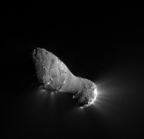
Jets can be seen streaming out of the nucleus, or main body, of comet Hartley 2 in this image from NASA's EPOXI mission. The nucleus is approximately 2 kilometers (1.2 miles) long and .4 kilometers (.25 miles) across at the narrow "neck." Credit: NASA/JPL-Caltech/UMD
[/caption]
No, EPOXI isn’t the name of a new super glue, but an abbreviation for the continuation of Deep Impact. While the original mission to study Comet 9P/Tempel was a huge success, the spacecraft continues to explore objects of opportunity. Its name is derived from Extrasolar Planet Observations and Characterization (EPOCh) and the Deep Impact Extended Investigation (DIXI)… and it’s now fulfilling another goal as it swings by Comet Hartley 2. It approached, encountered and departed, sending back 117,000 images and spectral findings – along with some surprising observations.
“From all the imaging we took during approach, we knew the comet was a little skittish even before flyby,” said EPOXI Project Manager Tim Larson of NASA’s Jet Propulsion Laboratory in Pasadena, Calif. “It was moving around the sky like a knuckleball and gave my navigators fits, and these new results show this little comet is downright hyperactive.”
What EPOXI found was a “hyperactive comet” – one that didn’t react in anticipated ways. From a distance of 431 miles (694 kilometers), the spacecraft watched as water and carbon-dioxide jets erupted from the flying space rock’s surface. While this in itself isn’t unusual, the fact that it didn’t happen uniformly caused scientists to sit up and take notice. Jets occurred at both ends of the comet with the strongest activity centered on the small end. Water vapor ejected from the central portion showed a notable lack of carbon-dioxide and ice, leading investigators to speculate the material was re-deposited from the ends of Hartley 2.
“Hartley 2 is a hyperactive little comet, spewing out more water than most other comets its size,” said Mike A’Hearn, principal investigator of EPOXI from the University of Maryland, College Park. “When warmed by the sun, dry ice — frozen carbon dioxide — deep in the comet’s body turns to gas jetting off the comet and dragging water ice with it.”
A large, diffuse cloud of CN gas surrounds the nucleus of Hartley 2 in this image from NASA's EPOXI mission. The gas forms a cloud of more than 200,000 kilometers (about 124,000 miles) in radius, compared to the comet's size of about 2 kilometers (1.24 miles). Credit: NASA/JPL-Caltech/UMDIs Hartley 2 unique? No. Scientists are aware of at least a dozen comets that behave similarly, but this is the first we’ve been able to examine closely via a spacecraft. These odd comets are extremely active for their size and may be driven by carbon dioxide or carbon monoxide. “These could represent a separate class of hyperactive comets,” said A’Hearn. “Or they could be a continuum in comet activity extending from Hartley 2-like comets all the way to the much less active, “normal” comets that we are more used to seeing.”
What makes this new class of comets so unusual? Just three ingredients: deposits around the inactive center which may have originated at the ends, a tumbling state of rotation and a large end containing ubiquitous inclusions which can span`approximately 165 feet (50 meters) high and 260 feet (80 meters) wide. EPOXI also picked up another surprise at Hartley 2’s smaller end – shiny cubicals reaching 16 stories tall and two to three times more reflective than other average surface materials. But that’s not all. For nine days in September, the energetic comet expelled 10 million times more CN gas in its coma – a dramatic and unexpected change called the “CN anomaly”. It was analyzed by McFadden and Dennis Bodewits, a former postdoctoral fellow at NASA Goddard who is now at the University of Maryland, and their colleagues. This comet exhaust normally includes a similar amount of dust, but not in this case.
“We aren’t sure why this dramatic change happened,” says McFadden. “We know that Hartley 2 gives off considerably more CN gas than comet Tempel 1, which was studied earlier by a probe released by the Deep Impact spacecraft. But we don’t know why Hartley 2 has more CN, and we don’t know why the amount coming off the comet changed so drastically for a short period of time. We’ve never seen anything like this before.”