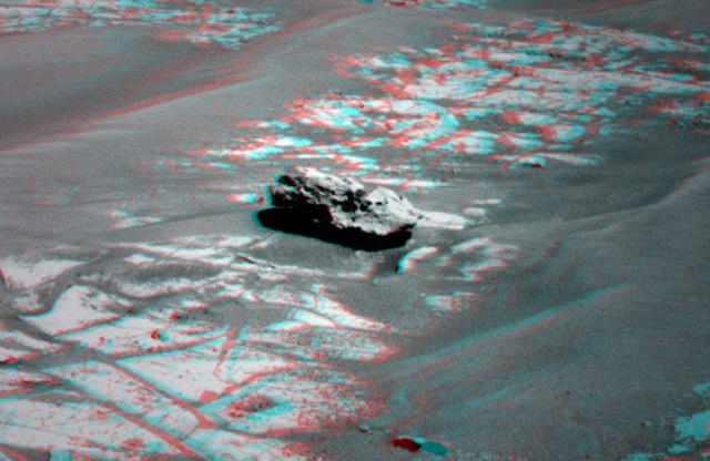
'Oileán Ruaidh' - the new rock found by the Opportunity rover. It could be another meteorite. Credit: NASA/JPL-Caltech/Cornell University. 3-D by Stuart Atkinson
[/caption]
The Opportunity rover has done it again — found another strange-looking rock sitting on Meridiani Planum, and it looks like another meteorite. “The dark color, rounded texture and the way it is perched on the surface all make it look like an iron meteorite,” said Matt Golombek from the MER science team. Unofficially named “Oileán Ruaidh” (pronounced ay-lan ruah), which is the Gaelic name (translated: Red Island) for an island off the coast of northwestern Ireland. The rock is about the size of a toaster: 45 centimeters (18 inches) wide from the angle at which it was first seen. Stu Atkinson has posted some enhanced images of the rock on his website, Road to Endeavour, which I have nabbed and posted here. Thanks Stu! The 3-D version above looks awesome with the red/green glasses. And look for more detailed images of the rock on his site soon, as Opportunity comes in for a closer look. UPDATE: As promised, Stu has provided an enhanced close-up of this rock, below.
Close up of a rock on Mars, possibly another meteorite. Credit: NASA/JPL/Cornell, enhanced by Stu Atkinson
Here’s an extreme close-up of Oileán Ruaidh, and it certainly has that “iron meteorite” look about it. It almost looks like the head of a craggy old snapping turtle!
Opportunity's panoramic camera's view of a dark rock that may be an iron meteorite. Image Credit: NASA/JPL-Caltech/Cornell University, enhanced by Stuart Atkinson
The answer to ‘what is water made of’ is as easy as you want it to be. Do you want to just do some superficial research or do you want to look a little deeper? Superficially, pure, distilled water is composed of 2 hydrogen atoms and 1 oxygen atom. If the sample of water is not ‘pure’, the composition of the sample can be different.
Salt water obviously contains salt, but it can contain many other trace elements. Fresh water from different sources will contain different elements and minerals. These come from the rocks the water washes over and the pollutants from farms and industry. The water that you drink will contain several additives used for purification plus the fluoride that is added for our health. Rain water will have any number of pollutants that have accumulated in the atmosphere.
At high temperatures and pressures, like those in the interior of giant planets, scientists think that water exists as ionic water in which the molecules break down into a soup of hydrogen and oxygen ions, and at even higher pressures as superionic water in which the oxygen crystallizes but the hydrogen ions float around freely within the oxygen lattice.
There are many interesting facts about water. Water is a tasteless, odorless liquid. The natural color of water and ice is slightly blue, although water appears colorless in small quantities. Ice also appears colorless, and water vapor is essentially invisible as a gas. Since the water molecule is not linear and the oxygen atom has a higher electronegativity than hydrogen atoms, water carries a slight negative charge. As a result, water has a electrical dipole moment. Water can form a large number of intermolecular hydrogen bonds(four). These factors lead to to water’s high surface tension and capillary forces. Water is often referred to as the universal solvent. All major cellular components are dissolved in water. Water is at its maximum density at 3.98°C. Oddly, it becomes less dense when it is cooled down to its solid form, ice. It expands to occupy 9% greater volume in this solid state, which accounts for the fact of ice floating on liquid water.
Water covers the majority of our planet and can be found in one form or another throughout the known universe. No matter where you are on Earth, water affects you in some way each day.
We have written many articles about water for Universe Today. Here’s an article about the density of water, and here’s an article about the water on Earth.
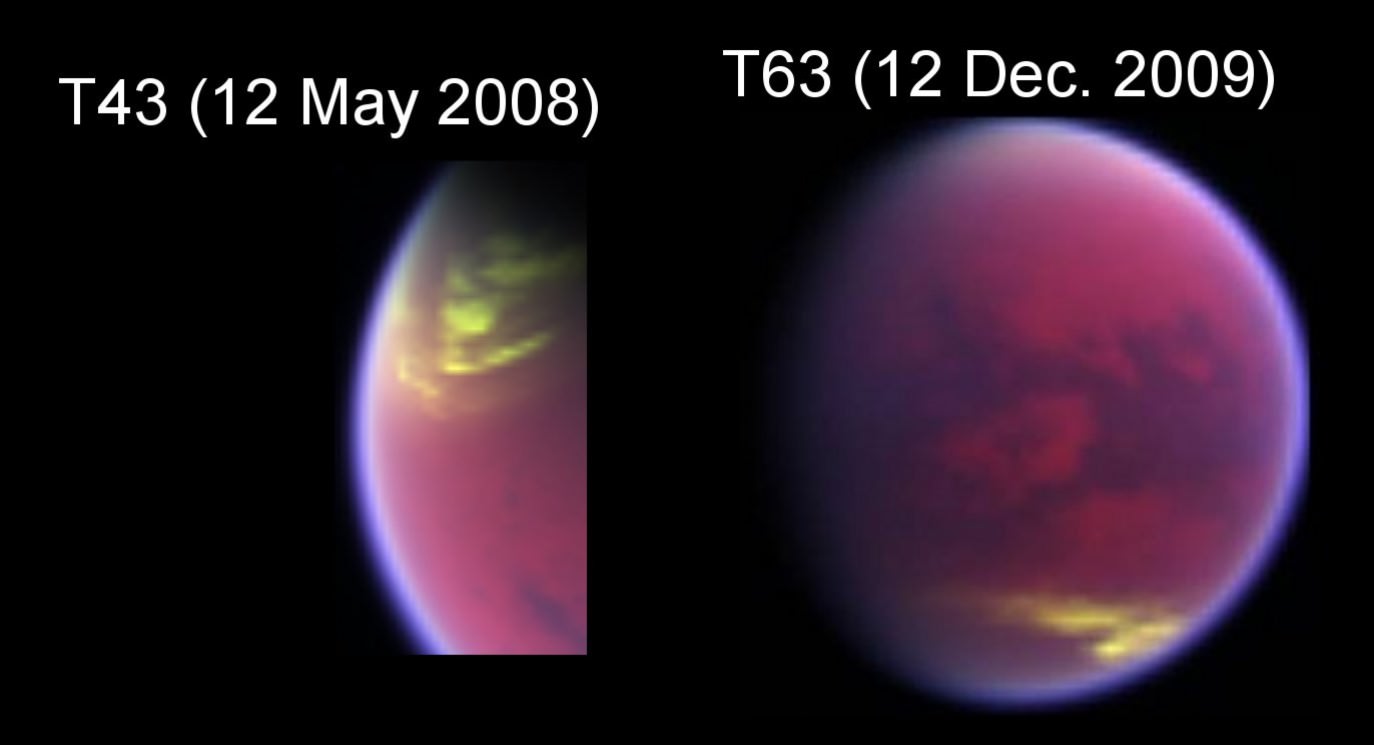
Left: T43 flyby of Titan - 12 May 2008 – VIMS images a large cloud that caps the north pole of Titan (yellowish tones). Right: T63 flyby of Titan - 12 December 2009 – VIMS still observes a huge cloud system at 40°S (yellowish tones) and the north pole of Titan free of clouds, a few months after the equinox. Credit: NASA/JPL/University of Arizona/University of Nantes/ University of Paris Diderot
[/caption]
The beauty of an extended space mission is that scientists can make long term observations and find out things we’ve never known before. The Cassini spacecraft’s Visual and Infrared Mapping Spectrometer (VIMS) instrument has been monitoring clouds on Titan continuously since the spacecraft went into orbit around Saturn in 2004, and a team led by Sébastien Rodriguez (AIM laboratory – Université Paris Diderot) has used more than 2,000 VIMS images to create the first long-term study of Titan’s weather. Are they ready to make a weather forecast? They say Titan’s northern hemisphere is set for mainly fine spring weather, with polar skies clearing since the equinox in August last year.
Together with Saturn in its 30-years orbit around the Sun, Titan has seasons that last for 7 terrestrial years. The team has observed significant atmospheric changes between July 2004 (early summer in the southern hemisphere) and April 2010, the very start of northern spring. The images showed that cloud activity has recently decreased near both of Titan’s poles. These regions had been heavily overcast during the late southern summer until 2008, a few months before the equinox.
“Over the past six years, we’ve found that clouds appear clustered in three distinct latitude regions of Titan: large clouds at the north pole, patchy cloud at the south pole and a narrow belt around 40 degrees south. However, we are now seeing evidence of a seasonal circulation turnover on Titan – the clouds at the south pole completely disappeared just before the equinox and the clouds in the north are thinning out. This agrees with predictions from models and we are expecting to see cloud activity reverse from one hemisphere to another in the coming decade as southern winter approaches,” said Dr Rodriguez.
Fractional cloud coverage in Titan’s atmosphere integrated between July 2004 and April 2010. Black areas are cloud free and yellow are fully covered. Credit: NASA/JPL/University of Arizona/University of Nantes/ University of Paris Diderot
The team has used results from the Global Climate Models (GCMs) developed by Pascal Rannou (Institut Pierre Simon Laplace) to interpret the evolution of the observed cloud patterns over time. Northern polar clouds of ethane form in the Titan’s troposphere during the winter at altitudes of 30-50 km by a constant influx of ethane and aerosols from the stratosphere. In the other hemisphere, mid- and high-latitudes clouds are produced by the upwelling from the surface of air enriched in methane. Observations of the location and activity of Titan’s clouds over long periods are vital in developing a global understanding of Titan’s climate and meteorological cycle.
In Feburary 2010, the Cassini mission was extended to a few months past Saturn’s northern summer solstice in May 2017. This means that Rodriguez and his team will be able to observe the seasonal changes right the way through from mid-winter to mid-summer in the northern hemisphere.
“We have learned a lot about Titan’s climate since Cassini arrived in at Saturn but there is still a great deal to learn. With the new mission extension, we will have the opportunity to answer some of the key questions about the meteorology of this fascinating moon,” said Rodriguez.
Rodriguez presented the results at the European Planetary Science Congress 2010 in Rome.
One of the surprises coming from the discoveries of the class of exoplanets known as “Hot Jupiters” is that they are puffed up beyond what would be expected from their temperature alone. The interpretation of these inflated radii is that extra energy must be being deposited in the regions of the atmosphere with large amounts of circulation. This extra energy would be deposited as heat, causing the atmosphere to expand. But from where was this extra energy coming? New research is suggesting that ionized winds passing through magnetic fields may create this process. Continue reading “Electric Resistance May Make Hot Jupiters Puffy”
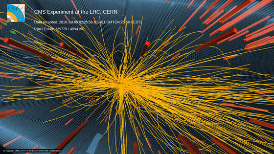
Image of a 7 TeV proton-proton collision in CMS producing more than 100 charged particles. Credit: CERN
[/caption]
Scientists at the Large Hadron Collider reported today they apparently have discovered a previously unobserved phenomenon in proton-proton collisions. One of the detectors shows that the colliding particles appear to be intimately linked in a way not seen before in proton collisions. The correlations were observed between particles produced in 7 TeV collisions. “The new feature has appeared in our analysis around the middle of July,” physicist Guido Tonelli told fellow CERN scientists at a seminar to present the findings from the collider’s CMS (Compact Muon Solenoid) detector.
The scientists said the effect is subtle and they have performed several detailed crosschecks and studies to ensure that it is real. It bears some similarity to effects seen in the collisions of nuclei at the RHIC facility located at the US Brookhaven National Laboratory, which have been interpreted as being possibly due to the creation of hot dense matter formed in the collisions.
CMS studies the collisions by measuring angular correlations between the particles as they fly away from the point of impact.
The scientists stressed that there are several potential explanations to be considered and the they presented their news to the physics community at CERN today in hopes of “fostering a broader discussion on the subject.”
“Now we need more data to analyze fully what’s going on, and to take our first steps into the vast landscape of new physics we hope the LHC will open up,” said Tonelli.
Proton running at the Large Hadron Collider is scheduled to continue until the end of October, during which time CMS will accumulate much more data to analyze. After that, and for the remainder of 2010, the LHC will collide lead nuclei.
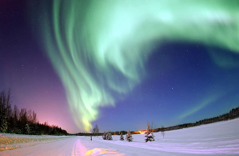
If you’ve even seen the Aurora Borealis live, you know how awe-inspiring it can be. But if you live too far south, or aren’t a night owl, there’s now a way for to you see the aurora, via the web, every night. Last night was the world premier of AuroraMAX – an online observatory which began streaming Canada’s northern lights live over the Internet. “Armchair skywatchers everywhere can now discover the wonder of the northern lights live on their home computer screen,” says Canadian Space Agency President Steve MacLean. “We hope that watching the dance of the northern lights will make you curious about the science of the sky and the relationship we have with our own star, the Sun.”
In addition to nightly broadcasts of the aurora, AuroraMAX will help demystify the science behind the phenomenon, offer tips for seeing and photographing auroras, and highlight Canadian research on the Sun-Earth relationship. The website will also include an image gallery with still photos and movies from previous nights.
Auroras occur as charged particles from the Sun collide with gases in Earth’s upper atmosphere. The launch of AuroraMAX coincides with the beginning of aurora season in northern Canada, which generally begins in late August or early September and ends in May. Aurora enthusiasts will be able to follow AuroraMAX through solar maximum, the most active period of the Sun’s 11-year cycle, which should produce more frequent and intense auroras on Earth. Solar maximum is currently expected in 2013.
AuroraMAX is a collaborative public engagement initiative between the CSA, the University of Calgary, the City of Yellowknife and Astronomy North.
Many astronomers feel that the Moon would be an excellent location for telescopes, — both on the surface and in lunar orbit – and these telescope could help answer some of the most important questions in astronomy and astrophysics today. One proposal calls for a lunar orbiting low frequency antenna that could measure the signatures of the first collapsing structures in the early universe. Dr. Jack Burns from the University of Colorado, Boulder, discussed the idea for the Lunar Cosmology Dipole Explorer (LCODE) at the NASA Lunar Science Institute’s Lunar Forum this summer.
What makes the Moon so inviting is that the lunar far side is uniquely radio quiet in the inner part of the solar system, as the far side is always facing away from the Earth, and the Moon itself blocks out any interfering man-made signals from radio, TV and satellites.
In this radio quiet zone, astronomers could study the very early universe, back to less than half a billion years after the Big Bang, probing what is called the Dark Ages, before the first stars and galaxies formed.
LCODE would be a satellite orbiting the Moon carrying a single dipole antenna, kind of like your car antenna, Burns said, but it has two ends. “It flies around the Moon and we take data only when we are above the far side, the shielded zone where we are free of radio interference,” said Burns, “and that allows us, because it is so quiet there, to take measurements of these very faint emissions from this very early era in our universe’s history.”
Example of dipole antenna.
The orbiting dipole would allow scientists to look for these signals over the entire sky. If that is successful, the next stage would be to put an array of dipole antennas on the surface, perhaps even about ten thousand antennas, and use it as a radio interferometer that would “allow us to actually get some resolution to do some imaging,” Burns said, “and explore the composition of these structures in the early universe that eventually go on to form stars and galaxies.”
Other proposals for doing radio astronomy from the Moon would be to study the sun at low frequencies, below 10 megahertz. The sun emits very strong low frequency radio waves, and these are related to Coronal Mass Ejections, which produce very high energy particles which can interfere with satellites and could potentially be very harmful to future astronauts traveling in interplanetary space. “We hope to be able to image and to understand how these particles are accelerated,” Burns said.
The other interesting regions of the Moon from which to do astronomy would be the poles in permanently shadowed craters, which are very cold — only about 40 degrees above absolute zero – which would make an excellent site for infrared telescopes which need to be cooled down to very low temperatures.
Marius Hills region on the Moon, from LRO's Wide Angle Camera.
[/caption]
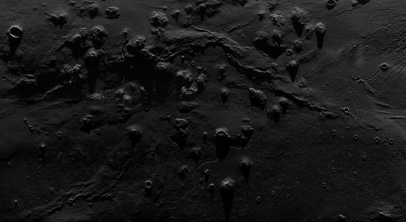
Here’s a look at the Moon in a way we’ve never quite seen it before: a close up, but wide angle view. The Lunar Reconnaissance Orbiter camera actually consists of three cameras: there are two narrow-angle cameras which make high-resolution, black-and-white images of the surface, with resolutions down to 1 meter (about 3.3 feet). A third, a wide-angle camera (WAC), takes color and ultraviolet images over the complete lunar surface at 100-meter (almost 330-foot) resolution. However, the raw wide-angle images are somewhat distorted by the camera, but Maurice Collins, a Moon enthusiast from New Zealand, found that putting several images together in a mosaic removes a lot of the distortions and produces a much clearer image. The results are nothing short of stunning; here are a few example of Maurice’s handiwork, including this jaw-dropping image of the Marius Hills region of the Moon. Click on any of these images for a larger version on Maurice’s website, Moon Science
Copernicus Crater on the Moon, captured by LROC's wide angle camera. Image processing by Maurice Collins
Maurice told me that he has been studying the Moon for about ten years now, and he does telescopic imaging of the Moon from his backyard Palmerston North, New Zealand as well as study the various spacecraft data. “I found out how to process the WAC images from Rick Evans (his website is here ) for the Octave processing method, and I also use a tool developed by Jim Mosher for another quicker technique,” Maurice said. Several of Maurice’s images have been featured on the Lunar Photo of the Day website.
Aristarchus Crater, as seen by LROC's wide angle camera. Image processing by Maurice Collins
Other areas of lunar imaging work he has done is using the Lunar Terminator Visualization Tool (LTVT) to study the lunar topography from the Lunar Orbiter Laser Altimeter (LOLA) digital elevation model laser altimeter data.
“Using a previous DEM from the Kaguya spacecraft I discovered a new large (630km long) mountain ridge radial to the Imbrium basin which I have nicknamed “Shannen Ridge” after my 9 year old daughter,” he said. See the image of Shannen Ridge here.
Maurice said he is usually out every clear night imaging or observing the Moon with his telescope. Thanks to Maurice for his wonderful work, and for allowing us at Universe Today to post some of the images. Check out his complete cache of WAC mosaics at his website.
CO2 is more than just the stuff that comes out of smokestacks, tailpipes, cigarettes and campfires. It is also a crucial element here on planet Earth, essential to life and its processes. It is used by plants to make sugars during photosynthesis. It is emitted by all animals, as well as some plants, fungi and microorganisms, during respiration. It is used by any organism that relies either directly or indirectly on plants for food; hence, it is a major component of the Carbon Cycle. It is also a major greenhouse gas, hence why it is so closely associated with Climate Change.
Joseph Black, a Scottish chemist and physician, was the first to identify carbon dioxide in the 1750s. He did so by heating calcium carbonate (limestone) with heat and acids, the result of which was the release of a gas that was denser than normal air and did not support flame or animal life. He also observed that it could be injected into calcium hydroxide (a liquid solution of lime) to produce Calcium Carbonate. Then, in 1772, another chemist named Joseph Priestley came up with of combining CO2 and water, thus inventing soda water. He was also intrinsic in coming up with the concept of the Carbon Cycle.
Since that time, our understanding of CO2 and its importance as both a greenhouse gas and an integral part of the Carbon Cycle has grown exponentially. For example, we’ve come to understand that atmospheric concentrations of CO2 fluctuate slightly with the change of the seasons, driven primarily by seasonal plant growth in the Northern Hemisphere. Concentrations of carbon dioxide fall during the northern spring and summer as plants consume the gas, and rise during the northern autumn and winter as plants go dormant, die and decay.
Traditionally, atmospheric CO2 levels were dependent on the respirations of animals, plants and microorganisms (as well as natural phenomena like volcanoes, geothermal processes, and forest fires). However, human activity has since come to be the major mitigating factor. The use of fossil fuels has been the major producer of CO2 since the Industrial Revolution. By relying increasingly on fossil fuels for transportation, heating, and manufacturing, we are threatening to offset the natural balance of CO2 in the atmosphere, water and soil, which in turn is having observable and escalating consequences for our environment. As is the process of deforestation which deprives the Earth of one it’s most important CO2 consumers and another important link in the Carbon Cycle.
As of April 2010, CO2 in the Earth’s atmosphere is at a concentration of 391 parts per million (ppm) by volume. For an illustrated breakdown of CO2 emissions per capita per country, click here.
We have written many articles about Carbon Dioxide for Universe Today. Here’s an article about the Carbon Cycle Diagram, and here’s an article about Greenhouse Effect.
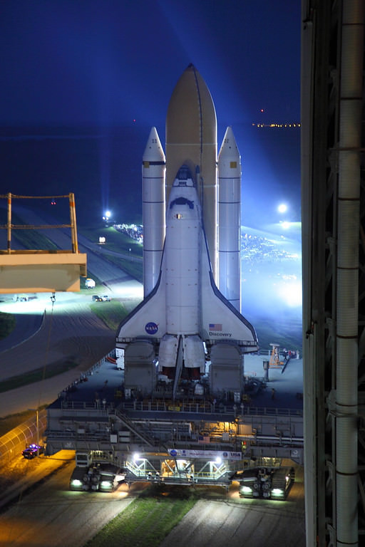
Discovery on the way to the launchpad. Credit: Alan Walters (awaltersphoto.com) for Universe Today.
[/caption]
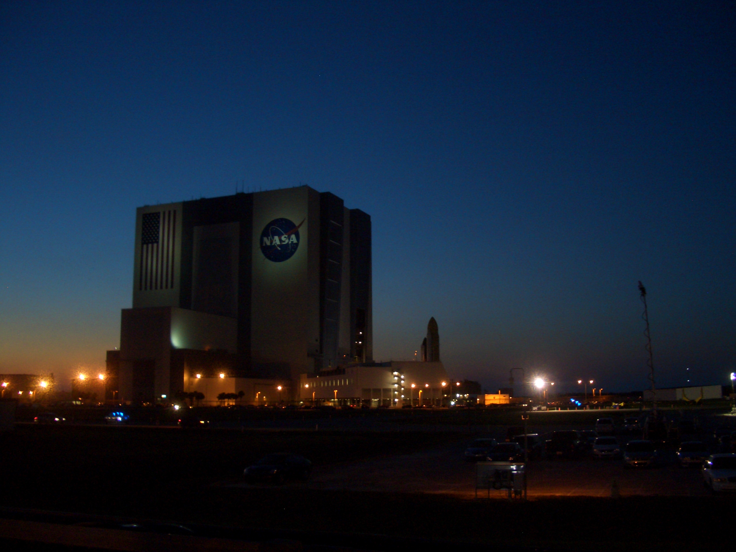
CAPE CANAVERAL – The space shuttle Discovery, its nosed pointed toward the sky, its belly attached to the massive, orange External Tank (ET) and twin Solid Rocket Boosters (SRB) slowly but surely emerged from the cavernous Vehicle Assembly Building at 7:24 p.m. EDT on Sept. 20. This marks the final time Discovery is scheduled to make the 3.4 – mile trip to Launch Complex 39A (LC39A) in preparation for her last planned mission – STS-133.
Discovery emerges from the Vehicle Assembly Building. Credit: Alan Walters (awaltersphoto.com) for Universe Today.
Bathed in spotlights Discovery’s last rollout was a bittersweet moment for workers that have cared for the orbiter. Discovery was rolled out four hours earlier than normal so that workers could take pictures. Rollout is conducted in the evening hours to prevent potential damage from possible lightning strikes. The crawler-transporter moves at a blistering mile-an-hour, but despite this slow speed, the vehicle and its precious cargo create an amazing spectacle.
Discovery emerges from the Vehicle Assembly Building on its way to LC39A. Photo Credit: Jason Rhian
Discovery is currently scheduled to lift off from LC39A on Nov. 1 at 4:40 p.m. EDT. Afterward Discovery will be maintained in flight ready condition in case the orbiter is needed to fly a possible rescue mission. After the end of the shuttle era, Discovery will go to the Smithsonian Air and Space Museum located in Washington D.C.
There are two crawler-transporters that NASA has used to transport spacecraft from the VAB to LC39A. They were originally used to transport the mighty Saturn family of rockets during the Apollo era. The crawler-transporters were designed by Bucyrus International and built by Marion Power Shovel. The vehicles cost $14 million a piece and are the largest self-powered track vehicles in the world.
Gleaming in white, Discovery reflects the glory of the shuttle program onto the waters of the Turn Basin. Photo Credit: Jason Rhian
STS-133 marks the 35th flight to the orbiting outpost and the 39th flight for Discovery and the 133rd flight in the space shuttle program. The crew members for this mission are Commander Steven Lindsey, Pilot Eric Boe and Mission Specialists Alvin Drew, Michael Barratt, Tim Kopra and Nicole Stott. Discovery will deliver and install the Leonardo Permanent Multipurpose Module (PMM), the Express Logistics Carrier 4 as well as deliver critical spare components to the ISS. Also onboard is the first humanoid robot to fly in space, Robonaut-2. For those that have cared for the orbiter however, this is just another day at the office.
Discovery. Credit: Alan Walters (awaltersphoto.com) for Universe Today
“For me seeing Discovery head to the pad brings to mind all the hard work done by the team that has brought us to this point, ” Discovery’s Flow Director, Stephanie Stilson said. “While every rollout is a major milestone for us, this happens to be the last but we are trying to look at it as just another rollout to the pad.”
This night journey is scheduled to be the last for Discovery, the oldest orbiter in NASA's shuttle fleet. Credit: Alan Walters (awaltersphoto.com) for Universe Today.Discovery in the VAB, prior to rollout. Credit: Alan Walters (awaltersphoto.com) for Universe Today.Great view of Discovery in the VAB. Credit: Alan Walters (awaltersphoto.com)
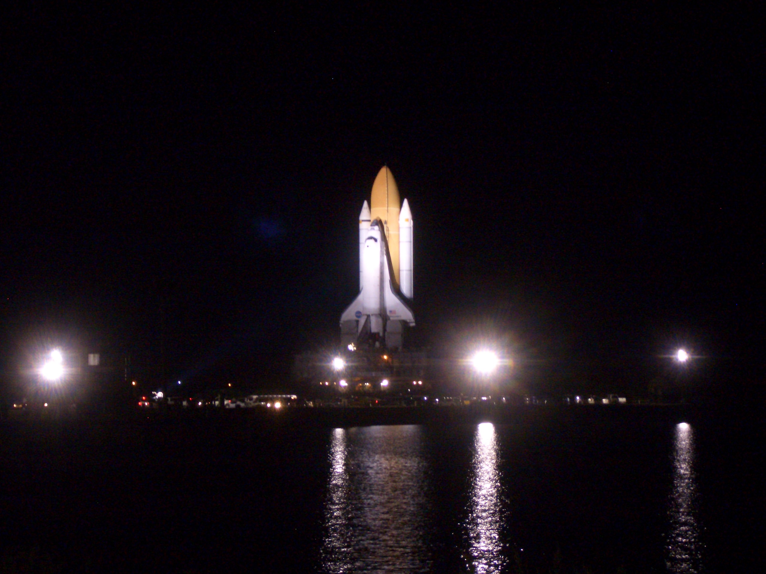
UPDATE: And here are some shots of Discovery at the launchpad:
Discovery arrives at the launchpad. Credit: Alan Walters (awaltersphoto.com) for Universe Toda


 for Universe Today.")
 for Universe Today")
 for Universe Today.")
 for Universe Today.")
")
 for Universe Today")